Image credit: NASA
NASA's Terra satellite is keeping a watchful camera pointed towards a glacier in the mountains of Peru. A large crack has appeared in the sheet of ice, and it could crumble into Lake Palcacocha, sending a wall of water and rubble into a nearby town of 60,000 people. This has been a controversial announcement, however, with several US and Peruvian geologists feel that the danger is exaggerated.
An Earth-monitoring instrument aboard NASA's Terra satellite is keeping a close eye on a potential glacial disaster-in-the-making in Peru's spectacular, snow-capped Cordillera Blanca (White Mountains), the highest range of the Peruvian Andes.
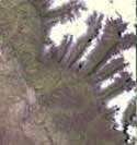
Data from NASA's Advanced Spaceborne Thermal Emission and Reflection Radiometer (Aster) is assisting Peruvian government officials and geologists in monitoring a glacier that feeds Lake Palcacocha, located high above the city of Huaraz, 270 kilometers (168 miles) north of Lima. An ominous crack has developed in the glacier. Should the large glacier chunk break off and fall into the lake, the ensuing flood could hurtle down the Cojup Valley into the Rio Santa Valley below, reaching Huaraz and its population of 60,000 in less than 15 minutes.
"Remote sensing instruments like Aster can serve a vital role in mountain hazard management and disaster mapping by providing rapid access to data, even in regions not easily accessible by humans," explained Dr. Michael Abrams, associate Aster team leader at NASA's Jet Propulsion Laboratory, Pasadena, Calif.
"Aster's unique vantage point from space gives scientists another tool with which to see early signs of potential glacial flood-burst events and to monitor changes in glacial behavior over time. In Huaraz, Peruvian authorities and scientists will incorporate Aster data along with data from ground-based monitoring techniques to better assess current conditions and take steps necessary to reduce risks to human lives and property," Abrams said.
Comparison images of the area and more information are available at: http://photojournal.jpl.nasa.gov/catalog/PIA03899. Huaraz can be seen in the images' left-center, with Lake Palcacocha in the images' upper right corners at the head of a valley, below the snow and glacier cap. The left image was acquired on November 5, 2001; the right on April 8, 2003.
Glacial flood-bursts, known by Peruvians as "aluviones," occur periodically when water is released abruptly from a previously ice-dammed lake alongside, within, or above a glacier. The release can be caused by various triggering events. These flood-bursts typically arrive with little or no warning, carrying liquid mud, large rock boulders and blocks of ice.
The Rio Santa Valley is no stranger to such disasters. Since 1702, floods caused by glaciological conditions have repeatedly caused death and destruction in the region. One particularly devastating event in 1941 destroyed approximately one-third of Huaraz, killing an estimated 5,000 to 7,000 people. Since then, the Peruvian government has emphasized control of the water level in Lake Palcacocha and other lakes in the region that pose similar threats. The efforts appear to have worked; since 1972, no destructive floods resulting from the breakout of glacial lakes have occurred. Nevertheless, officials are still monitoring the current situation closely.
Aster's broad spectral coverage and high spectral resolution is ideally suited for monitoring dynamic conditions and changes in Earth's landscape over time, including glacial advances and retreats. Its 14 spectral bands measure from the visible to the thermal infrared wavelength region, and it can "see" at a resolution of 15 to 90 meters (about 50 to 300 feet).
Aster provides scientists in numerous disciplines with critical information used for surface mapping and monitoring of dynamic conditions and changes over time. Example applications include monitoring glacial advances and retreats and potentially active volcanoes; identifying crop stress; determining cloud morphology and physical properties; evaluating wetlands; monitoring thermal pollution and coral reef degradation; mapping surface temperatures of soils and geology; and measuring surface heat balance. It can also image the same area as frequently as every other day in response to urgent priorities.
Aster is one of five Earth-observing instruments launched December 18, 1999, on NASA's Terra satellite. Japan's Ministry of Economy, Trade and Industry built the instrument. A joint U.S./Japan science team is responsible for validation and calibration of the instrument and the data products.
The Terra satellite is part of NASA's Earth Science Enterprise, a program dedicated to understanding the Earth as an integrated system and applying Earth system science to improve prediction of climate, weather and natural hazards using the unique vantage point of space.
The California Institute of Technology in Pasadena manages JPL for NASA.
NASA/JPL News Release