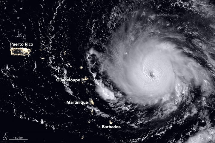
Record-setting Hurricane Irma barreled over the Caribbean islands of St. Martin, St. Barthelemy and Anguilla early Wednesday, destroying buildings with its sustained winds of 185 mph (297 kph), with rains and storm surges causing major flooding. The US National Hurricane Center listed the Category 5 Irma as the strongest Atlantic hurricane ever recorded north of the Caribbean and east of the Gulf of Mexico. The storm continues to roar on a path toward the U.S. and British Virgin Islands, Puerto Rico and possibly Florida, or along the southeast coast of the US.
This animation of NOAA's GOES East satellite imagery from Sept. 3 at 8:15 a.m. EDT (1215 UTC) to Sept. 6 ending at 8:15 a.m. EDT (1215 UTC) shows Category 5 Hurricane Irma as it moved west and track over St. Martin by 8 a.m. EDT on Sept. 6:
Different models have Irma traveling on slightly different paths and officials from all the areas that might possibly be hit are telling people to prepare and follow evacuation orders. National Hurricane Center scientist
Eric Blake said via twitter
that some models had the storm going one way, and some another. But he cautioned everyone in a potential path should take precautions. "Model trends can be quite misleading- could just change right back. It is all probabilistic at this point. It could still miss [one particular area]. But chances of an extreme event is rising."
Never seen a #hurricane this strong last so long in the Atlantic basin. #Irma is more like an unwelcome western Pacific supertyphoon ?? pic.twitter.com/55tFsbYWz1 — Eric Blake ? (@EricBlake12)
Saint-Martin and Anguilla appear to have taken a direct hit by cat 5 Hurricane #Irma. #GOES16 pic.twitter.com/1CN1JL0GEC
— NASA SPoRT (@NASA_SPoRT) September 6, 2017
The fleet of Earth-observing satellites are providing incredible views of this monster storm, and even astronauts on board the International Space Station are capturing views:
The International Space Station's external cameras captured a dramatic view of Hurricane Irma as it moved across the Atlantic Ocean Sept. 5. pic.twitter.com/mc61pt2G8O — Intl. Space Station (@Space_Station)
#GOES16 captured this geocolor image of Hurricane #Irma approaching Anguilla at about 7:00 am (EDT). Latest info @ https://t.co/cSGOfrM0lGpic.twitter.com/R24P0Q1EPm — NOAA Satellites (@NOAASatellites)
GOES-16 view of #HurricaneIrma at 30-second intervals covering 5-hour period ending at 352 AM CDT (9/6), including its passage over Barbuda. pic.twitter.com/WL6l6klPKw — NWS Twin Cities (@NWSTwinCities)
The eye of a category 5 hurricane. #Irma#GOES16pic.twitter.com/eATVZspJZx — NASA SPoRT (@NASA_SPoRT)
While satellite views provide the most comprehensive view of Irma's potential track, there's also a more 'hands-on' approach to getting data on hurricanes. NOAA hurricane hunter Nick Underwood posted this video while his plane flew into Hurricane Irma yesterday. The plane's specialized instruments can take readings on the storm that forecasters can't get anywhere else:
My day at the office. #HurricaneIrma@NOAA_HurrHunterpic.twitter.com/wpH83NIc6m — Nick Underwood (@TheAstroNick)
But Irma isn't the only storm to keep an eye on. Tropical storms Katia and Jose are also on the horizon:
An overview of the active tropics: 24-hour animation of TS #Katia (left), Hurricane #Irma (center), and TS #Jose (right). #GOES16pic.twitter.com/DiuhZP4f6y — NASA SPoRT (@NASA_SPoRT)
In the meantime, a launch is scheduled from Cape Canaveral on Thursday, September 7. SpaceX is hoping to launch the US Air Force's X-37B reusable spaceplane, but current forecasts put only a 50% chance of weather suitable enough on Thursday, and only 40% on Friday. We'll keep you posted.
For the latest satellite views, the Twitter accounts above are posting regular updates.
[caption id="attachment_137072" align="aligncenter" width="446"]
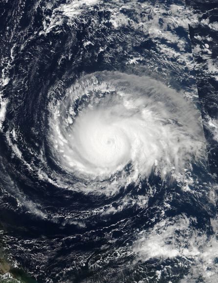
On Sept. 4 at 17:24 UTC, NASA-NOAA's Suomi NPP satellite captured this view of Hurricane Irma as a Category 4 hurricane approaching the Leeward Islands.
Credits: NOAA/NASA Goddard MODIS Rapid Response Team.[/caption]