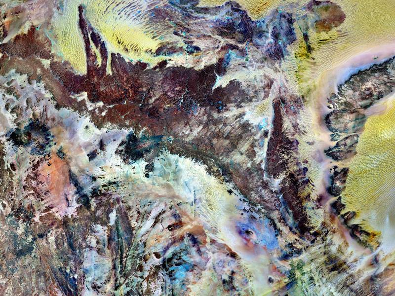
It’s time once again for another Where In The Universe Challenge. Name where in the Universe this image was taken and give yourself extra points if you can name the telescope or spacecraft responsible for the image. Post your guesses in the comments section, and check back on later at this same post to find the answer. To make this challenge fun for everyone, please don’t include links or extensive explanations with your answer. Good luck!
UPDATE: Answer now posted below!
This is planet Earth, specifically the Tassili n’Ajjer National Park, a part of the Sahara Desert, taken by the Landsat 7 satellite. Landsat 7 used a combination of infrared, near-infrared and visible light to better distinguish between the various rock types found in the region. Sand appears in shades of yellow and tan, while granite rocks appear brick red, and blue areas are likely salts. This area has a bone-dry climate with scant rainfall, but is not just a sea of sand like the rest of the Sahara Desert. Instead, the rocky plateau rises above the surrounding sand. Rich in geologic and human history, Tassili n’Ajjer is a United Nations Educational, Scientific and Cultural Organization (UNESCO) World Heritage Site, and covers 27,800 square miles (72,000 square kilometers) in southeastern Algeria.
This image is part of a special collection of images put out by NASA for Earth Day. See the entire collection at this link.


some mineral under a microscope?
It is the Tassili n’Ajjer National Park (also known as the Plateau of the Rivers), which is a mountain range in the Sahara Desert. The image is by the Landsat satellite.
😎
P.S. Landsat 7, that is.
It is a long lost Picasso. Or maby retreeting permafrost on Mars, I think I see Dunes on the right and top of the photo. Nancy, I finally get first shot at one, and I have no clue.
Kandinsky.
A person after my heart!
Ditto with Tassili n’Ajjer National Park.
Umm, Earth,… that’s all I got.
Looks like Jupiter’s moon Io.
Hmm, on the other hand, {sorry Potatoswatter, no links please -ed.}
No link, as per the editor, but a search for Flickr for Tassili n’Ajjer turns up some great photos.
Late ;( Tassili n’Ajjer National Park by Landsat.
Almost certain. An early painting by Wassily Kandinsky!
This just happens to be an ASTER and USGS thermal image of Death Valley. I’m guessing it is a 2007 image.
No prize for me. It’s actually the Tassili n’Ajjer National Park in the Sahara Desert. It was taken in 2000 by Landsat 7 using the infrared, near infrared, and visible light spectrums. I did a post on this not long ago titled “Picasso Disses Christies”.
Having been near there on the ground, it is hard to reconcile with this photo, but it is definitely Tassili n’Ajjer National Park, in Algeria.
I didn’t see the original post, but I promise I did not cheat! I guessed Earth, somewhere in N. Africa. I’ve never heard of Tassili n’Ajjer National Park, so I’m calling it correct. The dunes and river valley were the give-away. Not too many places with both adjoining.