Here's a look at Typhoon Choi-Wan. This is a big storm covering a huge area, and luckily it is now weakening as it continues to move northeast over the Pacific Ocean. This image was taken on Sept. 18, 2009, by the Moderate Resolution Imaging Spectroradiometer (MODIS) on NASA’s Aqua Satellite. Although the storm maintains its tightly wound symmetric shape, the striking clear eye is gone, unlike the image below, which was taken on Sept. 15. Now a category 3 storm, Choi-wan now has winds of about 200 kilometers per hour (125 miles per hour or 110 knots), whereas on the 15th, sustained winds were clocked at between 250 kilometers per hour (155 miles per hour or 135 knots) and 240 km/hr (150 mph or 130 knots), according to the Joint Typhoon Warning Center. The storm continues to skirt along the coast of Japan, causing huge waves, but is not expected to make landfall.
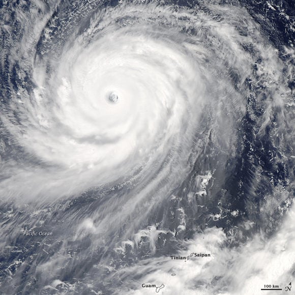
Choi-wan was a Category 4 super typhoon in this image, and the eye is clearly visible. NASA satellite imagery showed that the tops of the thunderstorms are so high they reached the tropopause, the level of atmosphere between the troposphere and stratosphere. Those high thunderstorms mean very heavy rainfall for the area underneath. The cloud tops extended to the 200 millibar level in the atmosphere where temperatures are as cold or colder than -63 Fahrenheit.
Other infrared imagery also showed the large temperature contrast between the icy cloud tops in the storm against the warm waters in the Western Pacific Ocean that continue to power the storm.
