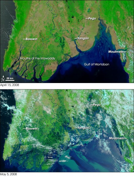
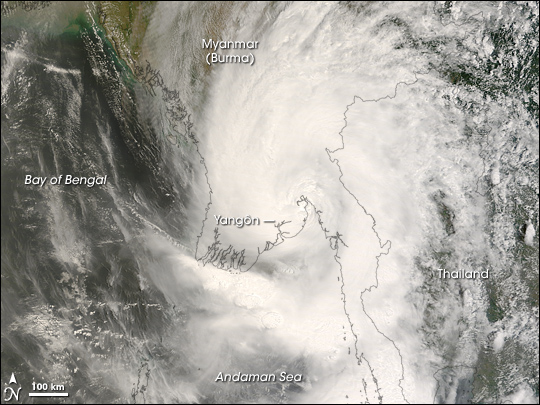
The cyclone that ravaged the southeast Asian country of Myanmar over the weekend was an incredibly deadly and destructive storm. News reports say at least 10,000 people were killed, and thousands more were missing as of May 5. Cyclone Nargis made landfall with sustained winds of 130 mph and gusts of 150-160 mph, which is the equivalent of a strong Category 3 or minimal Category 4 hurricane. This was the first cyclone of the 2008 season. Above is an image from NASA’s Terra satellite, and specifically the Moderate Resolution Imaging Spectroradiometer (MODIS.) You can see this storm was a whopper, however, by the time MODIS acquired this image on May 3 at 10:55 am local time the cyclone had lost much of its original strength and was at tropical storm strength. Even more astounding are the images available from MODIS of the landscape of Myanmar both before and after the cyclone hit.

The top image was taken on April 15, 2008, well before the storm and shows a calm landscape where rivers and lakes are visible, as well as the green of vegetation. In the lower image, taken on May 5, the entire coastal plain is flooded. News reports say the agricultural areas have been especially hard hit. But cities as well were affected. For example, Rangôn, with a population over 4 million is almost completely surrounded by floods. Several other large cities with populations of 100,000–500,000 are also in the area affected by the cyclone.
The MODIS Rapid Response Team has been processing the images as soon as they are available from the spacecraft in order to provide information about the storm and the region.
The blue dot on the globe below marks the Andaman Sea and the area affected by Cyclone Nargis.
Original News Source: NASA’s Earth Observatory


Truly a humanitarian tragedy of epic proportions. The preliminary death toll is already more than 6 times that of Hurricane Katrina, with that figure apparently set to sky rocket…
The poor souls of Myanmar just never seem to stop getting screwed over.
Couldn’t some one tell them about it in advance? That is the tragedy, watch and feel sorry – with all the weather sats up there, advanced warnings could have been issued to the Myanmar people and the government.
But probably no one did it! Where were CNN, BBC, etc etc.
They probably couldn’t afford their cable bill to get “The Weather Channel”.
I havent read up extensively but I believe some form of more global monitoring of these types of storms has been in the works? Either way, very hard to fathom the devastation and loss of life.
The Myanmar government did warn them. Except they said the winds were only going to be 30 MPH.
The Myanmar government did warn them. But their warning was very weak message.
Total 18 images after nagris in Yangon Myanmar.
http://picasaweb.google.com/nilarwynn/MyanmarCycloneNagris