Astronaut Luca Parmitano’s Chilling First-Hand Account of His Mishap in Space

ESA astronaut Luca Parmitano on EVA

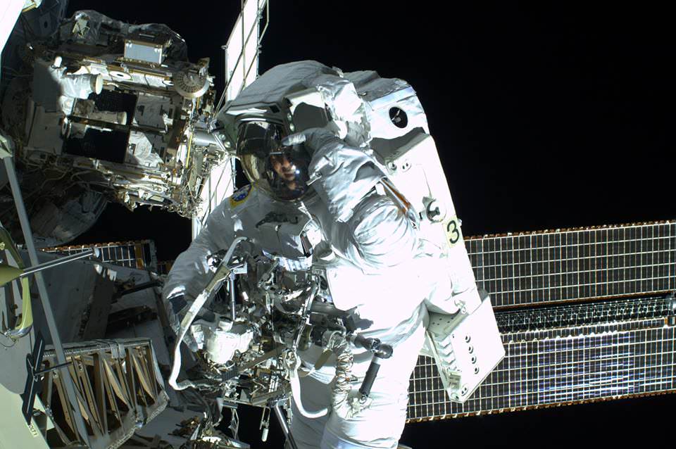
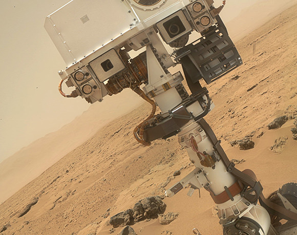
On July 16, Expedition 36 astronauts Chris Cassidy and Luca Parmitano had to cut a planned 7-hour spacewalk short after only an hour and a half due to a malfunction in Parmitano’s space suit, leaking water into his helmet and eventually cutting off his vision, hearing, and communications. Fortunately the Italian test pilot was able to safely return inside the ISS, but for several minutes he was faced with a pretty frightening situation: stuck outside Space Station with his head in a fishbowl that was rapidly filling with water.

On August 20, he shared his personal account of the event on his ESA blog.

“The only idea I can think of is to open the safety valve by my left ear: if I create controlled depressurisation, I should manage to let out some of the water, at least until it freezes through sublimation, which would stop the flow. But making a ‘hole’ in my spacesuit really would be a last resort…”

Parmitano’s description of his suit mishap begins as I’m sure all spacewalks do: with a sense of energy and enthusiasm for a job about to be performed in a challenging yet exotic and undeniably privileged location.

“My eyes are closed as I listen to Chris counting down the atmospheric pressure inside the airlock – it’s close to zero now. But I’m not tired – quite the reverse! I feel fully charged, as if electricity and not blood were running through my veins. I just want to make sure I experience and remember everything. I’m mentally preparing myself to open the door because I will be the first to exit the Station this time round. Maybe it’s just as well that it’s night time: at least there won’t be anything to distract me.”

But even though the EVA initially progressed as planned — ahead of schedule, in fact — it soon became obvious to Parmitano that something was amiss with his suit.

“The unexpected sensation of water at the back of my neck surprises me – and I’m in a place where I’d rather not be surprised. I move my head from side to side, confirming my first impression, and with superhuman effort I force myself to inform Houston of what I can feel, knowing that it could signal the end of this EVA.”

Luca Parmitano on EVA on July 16, 2013. (ESA)

It didn’t take long before an uncomfortable situation escalated into something potentially very dangerous.

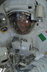
“As I move back along my route towards the airlock, I become more and more certain that the water is increasing. I feel it covering the sponge on my earphones and I wonder whether I’ll lose audio contact. The water has also almost completely covered the front of my visor, sticking to it and obscuring my vision. I realise that to get over one of the antennae on my route I will have to move my body into a vertical position, also in order for my safety cable to rewind normally. At that moment, as I turn ‘upside-down’, two things happen: the Sun sets, and my ability to see – already compromised by the water – completely vanishes, making my eyes useless; but worse than that, the water covers my nose – a really awful sensation that I make worse by my vain attempts to move the water by shaking my head. By now, the upper part of the helmet is full of water and I can’t even be sure that the next time I breathe I will fill my lungs with air and not liquid. To make matters worse, I realise that I can’t even understand which direction I should head in to get back to the airlock. I can’t see more than a few centimetres in front of me, not even enough to make out the handles we use to move around the Station.”

After contemplating opening a hole in his helmet to let out some of the water — a “last resort,” indeed — Parmitano managed to get back inside the airlock with help from Cassidy. But he still had to deal with the process of repressurization, which itself takes a few minutes.

Read more: Space Water Leak Prompts NASA Mishap Investigation

“I try to move as little as possible to avoid moving the water inside my helmet. I keep giving information on my health, saying that I’m ok and that repressurization can continue. Now that we are repressurizing, I know that if the water does overwhelm me I can always open the helmet. I’ll probably lose consciousness, but in any case that would be better than drowning inside the helmet.”

Now, a month after the mishap, Parmitano reflects on the nature of the event and of space travel in general.

“Space is a harsh, inhospitable frontier and we are explorers, not colonisers. The skills of our engineers and the technology surrounding us make things appear simple when they are not, and perhaps we forget this sometimes.”

“Better not to forget,” he advises.

Read Luca’s full blog post on the ESA site here.

ESA astronaut Luca Parmitano is the first of ESA’s new generation of astronauts to fly into space. Luca will serve as flight engineer on the Station for Expeditions 36 and 37. He qualified as a European astronaut and was proposed by Italy’s ASI space agency for this mission.

The Latest from Mars: Dried up Riverbed May Have Flowed into an Ancient Ocean

An artist's rendition of what water on Mars may have looked like. Source Credit: NASA

When it comes to Mars, the hot topic of study is water – a prerequisite for life.

While liquid water is currently not stable on the surface of Mars, there is extensive evidence that it may have been in the past. Astronomers have discovered dried up riverbeds, lake deltas, and evidence of widespread glaciers – to name but a few examples.

However, evidence for a massive standing body of water, such as an ocean, is hard to come by. Early climate models struggle to create circumstances under which liquid water would be stable at all. Nonetheless, an ocean spanning the northern lowlands (approximately one third of the planet) has been long hypothesized.

Scientists at Caltech may have just now confirmed this long-held hope in finding recent evidence for a vast Martian ocean.

The region under investigation is known as Aeolis Dorsa – a plain located at the border between the northern lowlands and the southern highlands. This plain contains many ridges, which are interpreted as ancient river channels.

“These ‘inverted’ channels are now elevated because the coarse sand and gravel carried by the channels is more resistant to erosion than the surrounding mud and silt making up the floodplain material,” Dr. Roman DiBiase, lead author on the study, told Universe Today.

Satellite images of Aeolis Dorsa were collected using the HiRISE camera aboard the Mars Reconnaissance Orbiter.  The resolution was so precise scientists could distinguish features as small as 25 centimeters – an impressive feat even when compared to images of the Earth.

For certain locations “repeat pictures taken with a slight offset enable the creation of stereo-images from which we can determine the relative elevations of features on the planet’s surface,” explains DiBiase. This impressive technique led to high-resolution topographic models, allowing the team to analyze the geometry and patterns of these inverted channels in unprecedented detail.

Not only do the channels spread out toward the end, they also slope steeply downward, forming a delta – a sedimentary deposit that forms where rivers flow into lakes or oceans.

While deltas have been identified on Mars before, all lie within distinct topographic boundaries, such as an impact crater. This is the most compelling evidence for a delta leading into an unconfined region – an ocean.

Final proof of a Martian ocean will advance our knowledge of the intricate interplay between water, climate, and life. “The history of water on Mars has implications not only for the evolution of Martian climate, but also for learning about the early evolution of Earth and Earth’s climate,” explains DiBiase.

As always, further research is needed. Perhaps in the nearby future the Mars Reconnaissance Orbiter and Curiosity will compliment each other quite well – the orbiter taking images from above while Curiosity plays in the dirt, gathering samples in the riverbed.

The study was published in the Journal of Geophysical Research and may be found here.

LRO Makes a Map of the Moon’s Water

The blue areas show locations on the Moon's south pole where water ice is likely to exist (NASA/GSFC)

The Moon might seem like a poor place to hunt for water, but in fact there’s a decent amount of the stuff dispersed throughout the lunar soil — and even more of it existing as ice deposits in the dark recesses of polar craters. While the LCROSS mission crashed a rocket stage into one of these craters in October 2009 and confirmed evidence of water in the resulting plume of debris, there haven’t been any definitive maps made of water deposits across a large area on the Moon — until now.

Over the course of several years, NASA’s Lunar Reconnaissance Orbiter scanned the Moon’s south pole using its Lunar Exploration Neutron Detector (LEND) to measure how much hydrogen is trapped within the lunar soil. Areas exhibiting suppressed neutron activity — shown above in blue — indicate where hydrogen atoms are concentrated most, strongly suggesting the presence of water molecules… aka H2O.

The incredibly-sensitive LEND instrument measures the flux of neutrons from the Moon, which are produced by the continuous cosmic ray bombardment of the lunar surface. Even a fraction of hydrogen as small as 100 ppm can make a measurable change in neutron distribution from the surface of worlds with negligible atmospheres, and the hydrogen content can be related to the presence of water.

No other neutron instrument with LEND’s imaging capability has ever been flown in space.

Watch the video below for more details as to how LRO and LEND obtained these results:

“While previous lunar missions have observed indications of hydrogen at the Moon’s south pole, the LEND measurements for the first time pinpoint where hydrogen, and thus water, is likely to exist.”

What’s so important about finding water on the Moon? Well besides helping answer the question of where water on Earth and within the inner Solar System originated, it could also be used by future lunar exploration missions to produce fuel for rockets, drinking water, and breathable air. Read more here.

Video credit: NASA Goddard Space Flight Center

Curiosity Once Again in Safe Mode – If Only Briefly

Not even two and a half weeks after a memory glitch that sent NASA’s Curiosity rover into a safe mode on Feb. 27, the robotic Mars explorer once again went into standby status as the result of a software discrepancy — although mission engineers diagnosed the new problem quickly and anticipate having the rover out of safe mode in a couple of days.

“This is a very straightforward matter to deal with,” said Richard Cook, project manager for Curiosity at Jet Propulsion Laboratory in Pasadena. “We can just delete that file, which we don’t need anymore, and we know how to keep this from occurring in the future.”

Via a JPL press release, issued March 18:

“Curiosity initiated this automated fault-protection action, entering ‘safe mode’ at about 8 p.m. PDT (11 p.m. EDT) on March 16, while operating on the B-side computer, one of its two main computers that are redundant to each other. It did not switch to the A-side computer, which was restored last week and is available as a back-up if needed. The rover is stable, healthy and in communication with engineers.

“The safe-mode entry was triggered when a command file failed a size-check by the rover’s protective software. Engineers diagnosed a software bug that appended an unrelated file to the file being checked, causing the size mismatch.”

 The rover is stable, healthy and in communication with engineers.

– NASA’s Jet Propulsion Laboratory

Once Curiosity is back online its investigation into the watery history of Gale crater will resume, but another hiatus — this one planned — will commence on April 4, when Mars will begin passing behind the Sun from Earth’s perspective. Mission engineers will refrain from sending commands to the rover during a four-week period to avoid data corruption from solar interference.

Keep up with the latest news from the MSL mission here.

Then again, there’s a certain personality on Twitter who claims a slightly different reason for these recent setbacks…

Sarcastic Rover


A Hi-Res Mosaic of Mercury’s Crescent

A view of Mercury from MESSENGER’s October 2008 flyby (NASA / JHUAPL / Gordan Ugarkovic)

Every now and then a new gem of a color-composite appears in the Flickr photostream of Gordan Ugarkovic, and this one is the latest to materialize.

This is a view of Mercury as seen by NASA’s MESSENGER spacecraft during a flyby in October 2008. The image is a composite of twenty separate frames acquired with MESSENGER’s narrow-angle camera from distances ranging from 18,900 to 17,700 kilometers and colorized with color data from the spacecraft’s wide-angle camera. (North is to the right.)

Click the image for a closer look, and for an even bigger planet-sized version click here. Beautiful!

The images that made up this mosaic were taken two and a half years before MESSENGER entered orbit around Mercury on March 19, 2011 UT, becoming the first spacecraft ever to do so and making Mercury the final “classical” planet to be orbited by a manmade spacecraft.

Since that time MESSENGER has completed well over 1,000 orbits and taken more than 100,000 images of the first planet in the Solar System, which filled in most of our gaps in Mercury’s map and showed us many never-before-seen features of the planet’s Sun-scoured surface. And just this past year MESSENGER’s extended mission helped confirm what could be called its most important discovery of all: water ice on Mercury’s north pole.

2012_Year_Highlights-1This was even selected by Scientific American as one of the Top 5 Space Stories of 2012.

With all that’s been achieved by MESSENGER in 2011 and 2012, 2013 is looking to be an interesting year!

“We learned a great deal about Mercury over the past year,” said MESSENGER Principal Investigator Sean Solomon of Columbia University’s Lamont-Doherty Earth Observatory. “The team published three dozen scientific and technical papers and delivered more than 150 presentations at national and international meetings. New measurements continue to stream back from our spacecraft, and we can look forward with excitement to many additional discoveries in 2013.”

Follow the MESSENGER mission news here and see more of Gordan’s space images here.

Inset image: 12 Mercurial discoveries by MESSENGER in 2012. Click to review.

The Moon’s Water Comes From the Sun

An image of debris, ejected from Cabeus crater and into the sunlight, about 20 seconds after the LCROSS impact. The inset shows a close-up with the direction of the sun and the Earth. Image courtesy of Science/AAAS

An image of water-filled debris ejected from Cabeus crater about 20 seconds after the 2009 LCROSS impact. Courtesy of Science/AAAS.

Comets? Asteroids? The Earth? The origins of water now known to exist within the Moon’s soil — thanks to recent observations by various lunar satellites and the impact of the LCROSS mission’s Centaur rocket in 2009 — has been an ongoing puzzle for scientists. Now, new research supports that the source of at least some of the Moon’s water is the Sun, with the answer blowing in the solar wind.


Spectroscopy research conducted on Apollo samples by a team from the University of Tennessee, University of Michigan and Caltech has revealed “significant amounts” of hydroxyl within microscopic glass particles found inside lunar soil, the results of micrometeorite impacts.

According to the research team, the hydroxyl “water” within the lunar glass was likely created by interactions with protons and hydrogen ions from the solar wind.

“We found that the ‘water’ component, the hydroxyl, in the lunar regolith is mostly from solar wind implantation of protons, which locally combined with oxygen to form hydroxyls that moved into the interior of glasses by impact melting,” said Youxue Zhang, Professor of Geological Sciences at the University of Michigan.

Hydroxyl is the pairing of a single oxygen atom to a single hydrogen atom (OH). Each molecule of water contains two hydroxyl groups.

Although such glass particles are widespread on the surface of the Moon — the researchers studied samples returned from Apollo 11, Apollo 16 and Apollo 17 missions — the water in hydroxyl form is not something that could be easily used by future lunar explorers. Still, the findings suggest that solar wind-derived hydroxyl may also exist on the surface of other airless worlds, like Mercury, Vesta or Eros… especially within permanently-shadowed craters and depressions.

“These planetary bodies have very different environments, but all have the potential to produce water,” said Yang Liu, University of Tennessee scientist and lead author of the team’s paper.

The discovery of hydroxyl within lunar glasses presents an “unanticipated, abundant reservoir” of water on the Moon, and possibly throughout the entire Solar System.

The study was published online Sunday in the journal Nature Geoscience.

Source: University of Michigan news release.

Inset image: a grain of lunar agglutinate glass from samples returned by Apollo astronauts (Yang Liu)

A River Ran Through It: Why Do They Think There Was Once Water on Mars?

Why is everyone so excited about these dusty Mars rocks?

This week’s big news was the announcement of evidence for flowing water on Mars, based on images of what appear to be smooth river rock-type pebbles found by Curiosity. Of course that’s a big statement to make, and for good reason — identifying water, whether present or past, is one step closer to determining whether Mars was ever a suitable place for life to develop. Yet here we are, not even two months into the mission and Curiosity is already sending us solid clues that Mars was once a much wetter place than it is now.

JPL released a video today providing a brief-but-informative overview of what Curiosity has discovered in Gale Crater and why it’s gotten everyone so excited.

Check it out so you’ll have something to talk about over the weekend:

MSL Long Term Planner Sanjeev Gupta reviews Curiosity’s latest discovery

Video: JPLNews. Images: NASA/JPL-Caltech

Clay Deposits Don’t Prove Existence of Ancient Martian Lakes

HiRISE image of branching features in the floor of Antoniadi Crater thought to contain clay material. (NASA/JPL/University of Arizona)

In the hunt for evidence of a warmer, wetter past on Mars, clay deposits have been viewed as good indications that stable liquid water existed on its surface for some time — perhaps even long enough to allow life to develop. But new research conducted here on Earth shows that some clays don’t necessarily need lakes of liquid water to form. Instead they can be the result of volcanic activity, which is not nearly so hospitable to life.

A research team led by Alain Meunier of the Université de Poitiers in France studied lavas containing iron and magnesium — similar to ancient clays identified on the surface of Mars — in the French Polynesian atoll of Moruroa. The team’s findings show that the same types of clay outcrops can be caused by the solidifying of water-rich magma in a volcanic environment, and don’t require Earthlike aquatic conditions at all.

The results also correlate to the deuterium-to-hydrogen (D/H) ratio within clays found in Martian meteorites.

Read: Life from Mars Could Have Polluted Earth

“To crystallize, clays need water but not necessarily liquid water,” said Alain Meunier to the Agençe France-Presse (AFP). “Consequently, they cannot be used to prove that the planet was habitable or not during its early history.”

Additionally, the clay deposits found on Mars can be several hundred meters thick, which seems to be more indicative of upwelling magma than interactions with water.

“[This] new hypothesis proposes that the minerals instead formed during brief periods of magmatic degassing, diminishing the prospects for signs of life in these settings,” wrote Brian Hynek from the Department of Geological Sciences at the University of Colorado, in response to the paper by Meunier et al. which was published in the September 9 edition of the journal Nature Geoscience.

This does not necessarily mean that all Martian clays weren’t formed in the presence of water, however. Gale Crater — where NASA’s Curiosity rover is now exploring — could very well have been the site of a Martian lake, billions of years in the past. Clays found there could have been created by water.

Read: Take a Trip to Explore Gale Crater

According to Bethany Ehlmann of the California Institute of Technology, co-author of the study, “there are particular characteristics of texture” to clays formed under different conditions, and “Gale is a different flavor of Mars.”

Perhaps Curiosity will yet discover if Gale’s original flavor was more cool and wet than hot and spicy.

Read more on New Scientist and Cosmos Magazine.

Inset image: Moruroa Atoll (NASA) 

Is Triton Hiding an Underground Ocean?

Voyager 2 mosaic of Neptune’s largest moon, Triton (NASA)

At 1,680 miles (2,700 km) across, the frigid and wrinkled Triton is Neptune’s largest moon and the seventh largest in the Solar System. It orbits the planet backwards – that is, in the opposite direction that Neptune rotates – and is the only large moon to do so, leading astronomers to believe that Triton is actually a captured Kuiper Belt Object that fell into orbit around Neptune at some point in our solar system’s nearly 4.7-billion-year history.

Briefly visited by Voyager 2 in late August 1989, Triton was found to have a curiously mottled and rather reflective surface nearly half-covered with a bumpy “cantaloupe terrain” and a crust made up of mostly water ice, wrapped around a dense core of metallic rock. But researchers from the University of Maryland are suggesting that between the ice and rock may lie a hidden ocean of water, kept liquid despite estimated temperatures of  -97°C (-143°F), making Triton yet another moon that could have a subsurface sea.

How could such a chilly world maintain an ocean of liquid water for any length of time? For one thing, the presence of ammonia inside Triton would help to significantly lower the freezing point of water, making for a very cold — not to mention nasty-tasting — subsurface ocean that refrains from freezing solid.

In addition to this, Triton may have a source of internal heat — if not several. When Triton was first captured by Neptune’s gravity its orbit would have initially been highly elliptical, subjecting the new moon to intense tidal flexing that would have generated quite a bit of heat due to friction (not unlike what happens on Jupiter’s volcanic moon Io.) Although over time Triton’s orbit has become very nearly circular around Neptune due to the energy loss caused by such tidal forces, the heat could have been enough to melt a considerable amount of water ice trapped beneath Triton’s crust.

Related: Titan’s Tides Suggest a Subsurface Sea

Another possible source of heat is the decay of radioactive isotopes, an ongoing process which can heat a planet internally for billions of years. Although not alone enough to defrost an entire ocean, combine this radiogenic heating with tidal heating and Triton could very well have enough warmth to harbor a thin, ammonia-rich ocean beneath an insulating “blanket” of frozen crust for a very long time — although eventually it too will cool and freeze solid like the rest of the moon. Whether this has already happened or still has yet to happen remains to be seen, as several unknowns are still part of the equation.

“I think it is extremely likely that a subsurface ammonia-rich ocean exists in Triton,” said Saswata Hier-Majumder at the University of Maryland’s Department of Geology, whose team’s paper was recently published in the August edition of the journal Icarus. “[Yet] there are a number of uncertainties in our knowledge of Triton’s interior and past which makes it difficult to predict with absolute certainty.”

Still, any promise of liquid water existing elsewhere in large amounts should make us take notice, as it’s within such environments that scientists believe lie our best chances of locating any extraterrestrial life. Even in the farthest reaches of the Solar System, from the planets to their moons, into the Kuiper Belt and even beyond, if there’s heat, liquid water and the right elements — all of which seem to be popping up in the most surprising of places — the stage can be set for life to take hold.

Read more about this here on Astrobiology.net.

Inset image: Voyager 2 portrait of Neptune and Triton taken on August 28, 1989. (NASA)

Why Doesn’t Earth Have More Water?

Water, water everywhere… Coleridge’s shipbound ancient mariners were plagued by a lack of water while surrounded by a sea of the stuff, and while 70% of Earth’s surface is indeed covered by water (of which 96% is salt water, hence not a drop to drink) there’s really not all that much — not when compared to the entire mass of the planet. Less than 1% of Earth is water, which seems odd to scientists because, based on conventional models of how the Solar System formed, there should have been a lot more water available in Earth’s neck of the woods when it was coming together. So the question has been floating around: why is Earth so dry?

According to a new study from the Space Telescope Science Institute in Baltimore, MD, the answer may lie in the snow.

The snow line, to be exact. The region within a planetary system beyond which temperatures are cold enough for water ice to exist, the snow line in our solar system is currently located in the middle of the main asteroid belt, between the orbits of Mars and Jupiter. Based on conventional models of how the Solar System developed, this boundary used to be closer in to the Sun, 4.5 billion years ago. But if that were indeed the case, then Earth should have accumulated much more ice (and therefore water) as it was forming, becoming a true “water world” with a water mass up to 40 percent… instead of a mere one.

As we can see today, that wasn’t the case.

Planets such as Uranus and Neptune that formed beyond the snow line are composed of tens of percents of water. But Earth doesn’t have much water, and that has always been a puzzle.”

– Rebecca Martin, Space Telescope Science Institute 

A study led astrophysicists Rebecca Martin and Mario Livio of the Space Telescope Science Institute took another look at how the snow line in our solar system must have evolved, and found that, in their models, Earth was never inside the line. Instead it stayed within a warmer, drier region inside of the snow line, and away from the ice.

“Unlike the standard accretion-disk model, the snow line in our analysis never migrates inside Earth’s orbit,” Livio said. “Instead, it remains farther from the Sun than the orbit of Earth, which explains why our Earth is a dry planet. In fact, our model predicts that the other innermost planets, Mercury, Venus, and Mars, are also relatively dry. ”

Read: Rethinking the Source of Earth’s Water

The standard model states that in the early days of a protoplanetary disk’s formation ionized material within it gradually falls toward the star, drawing the icy, turbulent snow line region inward. But this model depends upon the energy of an extremely hot star fully ionizing the disk — energy that a young star, like our Sun was, just didn’t have.

“We said, wait a second, disks around young stars are not fully ionized,” Livio said. “They’re not standard disks because there just isn’t enough heat and radiation to ionize the disk.”


“Astrophysicists have known for quite a while that disks around young stellar objects are NOT standard accretion disks (namely, ones that are ionized and turbulent throughout),” added Dr. Livio in an email to Universe Today. “Disk models with dead zones have been constructed by many people  for many years. For some reason, however, calculations of the evolution of the snow line largely continued to use the standard disk models.”

Without fully ionized disk, the material is not drawn inward. Instead it orbits the star, condensing gas and dust into a “dead zone”  that blocks outlying material from coming any closer. Gravity compresses the dead zone material, which heats up and dries out any ices that exist immediately outside of it. Based on the team’s research it was in this dry region that Earth formed.

The rest, as they say, is water under the bridge.

The team’s results have been accepted for publication in the journal Monthly Notices of the Royal Astronomical Society.

Read the release on the Hubble news site here, and see the full paper here.

Lead image: Earth as seen by MESSENGER spacecraft before it left for Mercury in 2004. NASA/Johns Hopkins University Applied Physics Laboratory/Carnegie Institution of Washington. Disk model image: NASA, ESA, and A. Feild (STScI). Earth water volume image:  Howard Perlman, USGS; globe illustration by Jack Cook, Woods Hole Oceanographic Institution (©); Adam Nieman.