Gullies on a Martian sand dune in this trio of images from NASA's Mars Reconnaissance Orbiter deceptively resemble features on Earth that are carved by streams of water. However, these gullies likely owe their existence to entirely different geological processes apparently related to the winter buildup of carbon-dioxide frost. Image Credit: NASA/JPL-Caltech/University of Arizona
[/caption]
Intriguing images of brand new, fresh gullies on Mars has most of us thinking of one thing: water. But at least for one type of Mars gully, carbon dioxide frost is the impetus behind fresh flows showing up on images from orbiting spacecraft.
“Gullies that look like this on Earth are caused by flowing water, but Mars is a different planet with its own mysteries,” said Serina Diniega, author of a new paper published in the journal Geology. “The timing we see points to carbon dioxide, and if the mechanism is linked to carbon-dioxide frost at these dune gullies, the same could be true for other gullies on Mars.”
Scientists have seen evidence of fresh gullies on Mars, beginning 2000 with images from the Mars Global Surveyor. Different mechanisms were proposed including water and carbon dioxide, as well as other forces.
On the HiRISE website, searching for “gullies” provides a bounty of images. Some fresh gullies are on sand dunes, commonly starting at a crest. Others are on rockier slopes, such as the inner walls of craters, sometimes starting partway down the slope.
Active Dune Gullies in Kaiser Crater (ESP_018186_1330) Active Dune Gullies in Kaiser Crater. Credit: NASA/JPL/University of Arizona
While a graduate student at the University of Arizona, Tucson, Diniega tracked changes in gullies on faces of sand dunes in seven locations on southern Mars. In looking at before-and-after images, in all cases, the gullies appeared after the known winter build-up of carbon-dioxide frost on the dunes. Before-and-after images that looked at periods in spring, summer and autumn showed no new activity.
Because new flows in these gullies apparently occured in winter, rather than at a time when any frozen water might be most likely to melt, Diniega and co-authors at the University of Arizona and Johns Hopkins University Applied Physics Laboratory believe they found evidence that carbon dioxide, rather than water, were responsible for the flows. Some carbon dioxide from the Martian atmosphere freezes on the ground during winter and sublimates back to gaseous form as spring approaches.
A series of images from HiRISE taken from 2008 to 2010 showing changes in a gully. Credit: NASA/JPL/University of Arizona
“One possibility is that a pile of carbon-dioxide frost accumulating on a dune gets thick enough to avalanche down and drag other material with it,” Diniega said. Other suggested mechanisms are that gas from sublimating frost could lubricate a flow of dry sand or erupt in puffs energetic enough to trigger slides.
The team focused their study on dune gullies that are shaped like rockier slope gullies, with an alcove at the top, a channel or multiple channels in the middle, and an apron at the bottom. The 18 dune gullies in which the researchers observed new activity range in size from about 50 meters or yards long to more than 3 kilometers (2 miles) long.
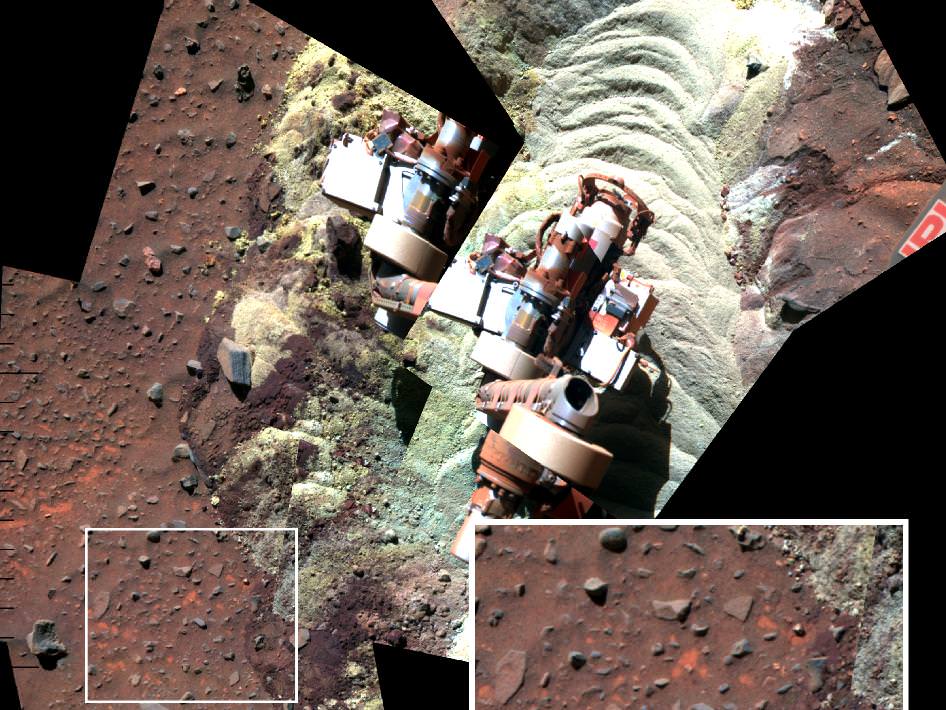
A mosaic of images shows the soil in front of the Mars Exploration Rover Spirit. Bright-toned soil was freshly exposed by the rover's left-front wheel. The inset show a magnified view of the nearby rectangles within the mosaic, showing the differences between undisturbed and disturbed soil. Credit: NASA/JPL-Caltech/Cornell University
[/caption]
She may be down, but she’s not out – out of the discovery department, anyway. Data from the Spirit Mars rover – currently in hibernation – shows evidence that water, perhaps as snow melt, trickled into the subsurface fairly recently and may be doing so on a continuing basis.
The area where Spirit became stuck in sandy soil in April of 2009 was churned up by her spinning wheels as engineers at the Jet Propulsion Laboratory attempted to drive her out of a veritable sand trap. This wheel-churning brought subsurface soil layers — which include the water soluble mineral ferric sulfate — up to the surface. Under a thin covering of windblown sand and dust, relatively insoluble minerals such as hematite, silica and gypsum are concentrated near the surface and more-soluble ferric sulfates have higher concentrations below that layer. This pattern suggests water has moved downward through the soil, dissolving and carrying the ferric sulfates.
The deputy principal investigator for the Spirit and Opportunity rover, Ray Arvidson and his team say that thin films of water may have entered the ground from frost or snow. (The Phoenix lander saw evidence of current snowfall.) The seepage could have happened during cyclical climate changes in periods when Mars tilted farther on its axis.
“The lack of exposures at the surface indicates the preferential dissolution of ferric sulfates must be a relatively recent and ongoing process since wind has been systematically stripping soil and altering landscapes in the region Spirit has been examining,” said Arvidson.
This isn’t the first time that Spirit’s wheels have churned up interesting stuff. Back in 2008, researchers said Spirit’s bum front wheel uncovered signs minerals that are found in hot springs, similar to what is at Yellowstone National Park on Earth, and similar hot springs may have once bubbled or steamed on Mars.
But there’s been no word from the rover since March 22, 2010, after she went into cold-induced hibernation. Because Spirit was stuck, the rover drivers could not get her in the best position to receive maximum sunlight.
“With insufficient solar energy during the winter, Spirit goes into a deep-sleep hibernation mode where all rover systems are turned off, including the radio and survival heaters,” said John Callas, project manager for Spirit and Opportunity. “All available solar array energy goes into charging the batteries and keeping the mission clock running.”
While she was stuck and still awake, researchers took advantage and examined in great detail soil layers the wheels had exposed, and also neighboring surfaces, making comparisons between the two. While trying to drive back out of her predicament, Spirit made 13 inches of progress in its last 10 backward drives before energy levels fell too low. Those drives exposed a new area of soil for possible examination if Spirit does awaken and if its robotic arm is still usable.
However, it is thought that the aging Spirit rover experienced the coldest temperatures ever, and it may not survive. Everyone is still holding out hope that the rover may yet make contact through one of the orbiting spacecraft and the Deep Space Network.
If Spirit does get back to work, the top priority is a multi-month study that can be done without driving the rover. The study would measure the rotation of Mars through the Doppler signature of the stationary rover’s radio signal with enough precision to gain new information about the planet’s core.
Meanwhile, over on the other side of Mars, the rover Opportunity has been making steady progress toward a large crater, Endeavour, which is now approximately 8 kilometers (5 miles) away.
Artist's impression of water under the Martian surface. If underground aquifers really do exist, the implications for human exploration and eventual colonization of the red planet would be far-reaching. (Illustration: ESA)
[/caption]
Images from the spacecraft orbiting Mars seem to indicate the Red Planet may once have had oceans and lakes, and researchers are still trying to figure out how these bodies of water could have developed. A new explanation is that underground aquifers fed water to the surface, forming the floors of ancient continental-scale basins on Mars. The groundwater emerged through extensive and widespread fractures, leading to the formation of river systems, large-scale regional erosion, sedimentary deposition and water ponding in widespread and long-lasting bodies of water in Mars northern plains.
J. Alexis Palmero Rodriguez, research scientist at the Planetary Science Institute PSI, has been studying the Martian northern lowlands region, finding extensive sedimentary deposits that resemble the abyssal plains of Earth’s ocean floors. It is also like the floors of other basins on Mars where oceans are thought to have developed.
The origin of these deposits and the formation of Martian lakes and seas has been a controversial subject over the years. One theory is that there was a sudden release of large volumes of water and sediment from zones of apparent crustal collapse known as “chaotic terrains.” However, these zones of collapse are on the whole rare on Mars, while the plains deposits are widespread and common within large basin settings, Rodriguez said.
From evidence in the planet’s northern plains (south of Gemini Scopuli in Planum Boreum), Rodriguez’ new model does not require sudden massive groundwater discharges. Instead, it advocates for groundwater discharges being widespread, long-lived and common in the northern plains of Mars.
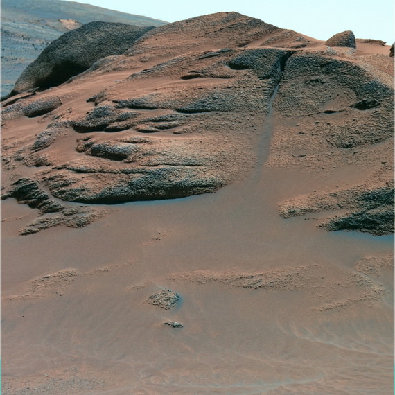
Large gully on Mars, seen by the Mars Reconnaissance Orbiter's HiRISE camera. Credit: NASA/JPL/University of Arizona
“With the loss over time of water from the subsurface aquifer, areas of the northern plains ultimately collapsed, creating the rough hilly surfaces we see today. Some plateaus may have avoided this fate and preserved sedimentary plains containing an immense record of hydrologic activity,” Rodriguez said. “The geologic record in the collapsed hilly regions would have been jumbled and largely lost.
“This model implies that groundwater discharges within basin settings on Mars may have been frequent and led to formation of mud pools, lakes and oceans. In addition, our model indicates this could have happened at any point in the planet’s history,” he said. “There could have been many oceans on Mars over time.”
If life existed in Martian underground systems, life forms could have been brought up to the surface via the discharges of these deep-seated fluids. Organisms and their fossils may therefore be preserved within some of these sedimentary strata, Rodriguez said.
This image shows a river that sprang from a past glacier from an unnamed crater in Mars’ middle latitudes. Credit: NASA/JPL/MSSS
[/caption]
No sooner do we post one article about water on Mars when it’s time for another. Planetary scientists have uncovered telltale signs of water on Mars — frozen and liquid — in the earliest period of the Red Planet’s history. They found evidence of running water that sprang from glaciers throughout the Martian middle latitudes as recently as the Amazonian epoch, several hundred million years ago. These glaciofluvial valleys were, in essence, tributaries of water created when enough sunlight reached the glaciers to melt a thin layer on the surface. This led to “limited surface melting” that formed channels that ran for several kilometers and could be more than 150 feet wide.
The finding is “more than ‘Yes, we found water,’” said Caleb Fassett from Brown University, who along with Brown research analyst James Dickson, professor James Head III, and geologists from Boston University and Portland State University published a paper in Icarus. “What we see now is there’s this complex history of different environments where water is being formed.”
The team analyzed 15,000 images snapped by the Context Camera (CTX) aboard the Mars Reconnaissance Orbiter to compile the first survey of glaciofluvial valleys on Mars. The survey was sparked by a glaciofluvial valley that Dickson, Fassett, and Head spotted within the Lyot crater, located in the planet’s middle latitudes. The team, in a paper last year in Geophysical Research Letters, dated that meltwater-inspired feature to the Amazonian.
In his survey, Fassett found dozens of other Amazonian-era ice deposits that spawned supraglacial and proglacial valleys, most of them located on the interior and exterior of craters in Mars’ midlatitude belt. “The youthfulness (of the features) is surprising,” he said. “We think of [post-Noachian] Mars as really, really cold and really, really dry, so the fact that these exist, in those kinds of conditions, is changing how we view the history of water on the planet.”
What makes the finding even more intriguing is that the Brown planetary scientists can study what they believe are similar conditions on Earth. Teams from Brown and Boston University have visited the Antarctic Dry Valleys for years, where the surfaces of glaciers melt during the austral summer, sparking enough meltwater to carve a channel. The team will return to the Dry Valleys later this year to continue the study of this microclimate.
“It’s sort of crazy,” said Dickson, a member of the Brown team who stayed in the Dry Valleys for three months last year. “You’re freezing cold and there’s glacial ice everywhere, and it gets just warm enough that you get a river.”
Fassett plans to search for more glaciofluvial valleys as more images come from the CTX, which has mapped roughly 40 percent of the planet.
Locations of nine exposures of hydrated silicate in northern plain craters, shown on a Mars Orbiter Laser Altimeter shaded relief map. Black squares indicate sites investigated with CRISM that did not yield detections. Image courtesy of Science/AAAS.
By looking at the mineralogy deep inside craters on Mars’ northern plains and comparing it to the makeup of regions in the southern hemisphere, scientists have found that widespread liquid water likely altered the majority of Red Planet’s crust about 4 billion years ago. However, the new findings do not support other recent studies that suggest a giant ocean covered Mars’ northern highlands.
Using the Mars Express OMEGA instrument and the Mars Reconnaissance Orbiter’s CRISM instrument, John Carter from Bibring at Université Paris in Orsay, France along with a group of scientists from France and the US, investigated large craters and found minerals which could have only formed in the presence of water. “We’ve detected hydrated minerals in about 10 of these craters,” Carter told Universe Today, “and we conclude that the ancient crust was altered in a similar way both in the south and in the north, in a very early environment which was much warmer and wetter than today’s.”
Carter added that in terms of Mars’ water history, this means liquid water existed near and on the surface of early Mars on a planetary scale, and is not restricted to select areas of the southern highlands.
Mars has dichotomy between north and south, (read our earlier article “The Two Faces of Mars Explained) so while the south is ancient, heavily cratered and high up, the north is smooth, with low-lying plains. It also is much younger and less cratered than the south. This is due to a volcanic mantling processes which filled up part of the lowlands and thus erased any former structures.
HRSC observation of Kunowsky crater, centered at 350.3°E, 56.8°N. (B) CTX close-up (image B01_009932_2370). CRISM mineral maps from observations FRT0000BAD4 and FRT0000C63C are overlaid in red (smectites or chlorite-prehnite) and green (olivine). The white dashed lines indicate the boundaries of the two adjacent observations. (C) HiRISE close-up (image PSP006860_2370) overlain by CRISM mineral maps. No HiRISE data are available over the chlorite-prehnite unit. Image courtesy of Science/AAAS
Carter and his team began their work based on studies of hundreds of sites in the southern hemisphere of Mars which were found to have hydrated minerals which formed on or near the surface some 4 billion ago in a wet and warm environment. While today Mars does not and cannot sustain liquid water on its surface, the scientists knew that a rather weak hydrological system had existed in the southern hemisphere, based on previous geological and morphological evidence.
If minerals in Mars’ northern hemisphere had formed in the presence of water, those minerals would have been buried by the widespread and intense lava flow which happened about 3 billion years ago, resurfacing that region of the planet. But looking into impact craters provides a window into Mars’ past by penetrating down through the lava flow, as well as showering chunks of the underlying crust across the nearby surface.
Carter said the data from OMEGA and CRISM show the mineral assemblages within and around these craters in the north as are very similar to what is seen in the southern ancient highlands, which includes phyllosilicates or other hydrated silicates.
“Our work broadens our view of liquid water on ancient Mars,” Carter said in an email, “spreading it to most of the planet, and may also provide a constraint on the timing of the northern hemisphere alteration with respect to its formation.”
Another conclusion, Carter said, is that these detections may be a constraint on when Mars could have possibly been conducive to the formation of life. “The main scenario which explains the dichotomy is that of an oblique impact between Mars and a fair sized celestial body, thus obliterating and re-melting a great deal of the northern hemisphere of Mars. Such an impact would surely have destroyed any pre-existing hydrated minerals at the depths at which we’re seeing them or we think they come from. Thus the water stability era likely took place after this giant impact, and did not last long (several hundred million years at most). Thus our work may provide a lower limit on this era.”
CTX–HRSC mosaic of Stokes crater, centered at 171.35°E, 55.56°N. (B) CTX closeup (image P20_008686_2356). CRISM mineral maps from observation FRT0000ADA4 are overlain in color. The white dashed lines indicate the boundaries of the CRISM observation. (C) HiRISE close-up (image PSP_009332_2360) of the Al-phyllosilicate “montmorillonite”-bearing unit. The sources of the material are the bright outcrops near the scarp summit (right), whereas the light-toned unit (left) is material transported downslope. (D) HiRISE close-up (image PSP_009332_2360) showing outcrops of olivine, Fe/Mg-, and Al-phyllosilicates in close spatial association. Image courtesy of Science/AAAS
Concerning the giant ocean scenario for the northern highlands, on which a paper was published just last week, Carter said his team’s findings show evidence against those circumstances. “Previous work by a number of teams have actually shown the unlikelihood of a giant northern ocean on Mars younger than 3 billion years as hypothesized by several researchers,” he said. “There is no morphological nor mineralogical evidence for such an ocean. In our 10 or so craters of the northern plains of Mars where we found hydrated minerals, we also found mafic minerals such as olivine. This olivine is almost ubiquitous in northern plain craters, and the vast majority of it is unaltered. Olivine is very readily altered by liquid water hence a giant ocean which would have submerged all these craters should have altered all the olivine, and this is seldom the case.”
Carter said that studying craters from orbit provides a bit of a challenge. “It is hard, for example, to distinguish rocks from orbit which may have been excavated by the impact or actually formed after the impact when the heat released and the existing water and/or ice interacted with the rock to form new minerals, creating hydrothermal environments. In our paper we put forward several reasons why an excavation scenario is favored to a post-impact hydrothermal scenario.”
But craters on Mars provide a better study of the past than craters on Earth, since craters may exist on Mars for billions of year without much degradation, while on Earth water, tectonics and plant growth all conspire to conceal and change craters. Carter said the excavated material on Mars will not be altered by the current ultra-dry, cool environment on the Red Planet.
This research new appears in the June 25, 2010 issue of Science.
Sources: AAAS/Science, email exchange with John Carter
n illustration of what Mars might have looked like some 3.5 billion years ago when an ocean likely covered one-third of the planet’s surface, according to a new University of Colorado at Boulder study. (Illustration by University of Colorado)
[/caption]
Like rising waters from a flood, the evidence for past water on Mars — and large amounts of it – keep mounting. The latest study, which combined the analysis of water-related features including scores of delta deposits and thousands of river valleys with a look at the possibility of a global hydrosphere on early Mars, found that a vast ocean likely covered one-third of the surface of Mars some 3.5 billion years ago.
“Collectively, these results support the existing theories regarding the extent and formation time of an ancient ocean on Mars,” said Gaetano Di Achille and Brian Hynek from the Univesity of Colorado at Boulder, in their article in Nature Geoscience, “and imply the surface conditions during the time probably allowed the occurrence of a global and active hydrosphere integrating valley networks, deltas and a vast ocean as major components of an Earth-like hydrologic cycle.”
The idea of an ocean on Mars has been repeatedly proposed and challenged over the past two decades, and just last week, another study proposed lakes in the Hellas Basin region on Mars. This new study provides further support for the idea of a sustained sea on the Red Planet during the Noachian era more than 3 billion years ago.
More than half of the 52 river delta deposits identified by the CU researchers — each of which was fed by numerous river valleys — likely marked the boundaries of the proposed ocean, since all were at about the same elevation. Twenty-nine of the 52 deltas were connected either to the ancient Mars ocean or to the groundwater table of the ocean and to several large, adjacent lakes, Di Achille said.
The study is the first to integrate multiple data sets of deltas, valley networks and topography from a cadre of NASA and European Space Agency orbiting missions of Mars dating back to 2001, said Hynek. The study implies that ancient Mars probably had an Earth-like global hydrological cycle, including precipitation, runoff, cloud formation, and ice and groundwater accumulation.
Di Achille and Hynek used a geographic information system, or GIS, to map the Martian terrain and conclude the ocean likely would have covered about 36 percent of the planet and contained about 30 million cubic miles, or 124 million cubic kilometers, of water. The amount of water in the ancient ocean would have formed the equivalent of a 1,800-foot, or 550-meter-deep layer of water spread out over the entire planet.
The volume of the ancient Mars ocean would have been about 10 times less than the current volume of Earth’s oceans, Hynek said. Mars is slightly more than half the size of Earth.
The average elevation of the deltas on the edges of the proposed ocean was remarkably consistent around the whole planet, said Di Achille. In addition, the large, ancient lakes upslope from the ancient Mars ocean likely formed inside impact craters and would have been filled by the transport of groundwater between the lakes and the ancient sea, according to the researchers.
A second study headed by Hynek and involving CU-Boulder researcher Michael Beach of LASP and CU-Boulder doctoral student Monica Hoke being published in the Journal of Geophysical Research–Planets — which is a publication of the American Geophysical Union — detected roughly 40,000 river valleys on Mars. That is about four times the number of river valleys that have previously been identified by scientists, said Hynek.
The river valleys were the source of the sediment that was carried downstream and dumped into the deltas adjacent to the proposed ocean, said Hynek. “The abundance of these river valleys required a significant amount of precipitation,” he said. “This effectively puts a nail in the coffin regarding the presence of past rainfall on Mars.” Hynek said an ocean was likely required for the sustained precipitation.
“One of the main questions we would like to answer is where all of the water on Mars went,” said Di Achille. He said future Mars missions — including NASA’s $485 million Mars Atmosphere and Volatile Evolution mission, or MAVEN, which is being led by CU-Boulder and is slated to launch in 2013 — should help to answer such questions and provide new insights into the history of Martian water.
The river deltas on Mars are of high interest to planetary scientists because deltas on Earth rapidly bury organic carbon and other biomarkers of life and are a prime target for future exploration. Most astrobiologists believe any present indications of life on Mars will be discovered in the form of subterranean microorganisms.
“On Earth, deltas and lakes are excellent collectors and preservers of signs of past life,” said Di Achille. “If life ever arose on Mars, deltas may be the key to unlocking Mars’ biological past.”
Hynek said long-lived oceans may have provided an environment for microbial life to take hold on Mars.
Seen close up, the Comanche outcrop shows both a granular texture and multiple layers. Scientists think it is volcanic debris draped over preexisting terrain. After it was deposited, the rock was soaked in hydrothermal water rich in carbonate minerals. False-color Pancam image. Credit: NASA/JPL/Cornell University
[/caption]
Even though the Mars Rover Spirit is asleep, a new look at old data from one of her instruments confirms the presence of large amounts of carbonate-rich rocks, which means that regions of the planet may have once harbored water. The Miniature Thermal Emission Spectrometer, or Mini-TES, instrument on the rover looked at an outcrop of rocks called “Comanche” back in 2005, but the instrument was partially “blinded” by dust. Only when scientists developed a special calibration to remove the spectral effects of the dust on the instrument was the spectral data revealed to show evidence for carbonate-rich outcrops in a range of low hills inside Gusev crater on Mars.
Spirit has gone into hibernation because of low power levels during the extremely cold winter months on Mars. She is stuck in some loose sand in the Home Plate region, and the rover teams were unable to get her solar panels in a good position to soak up the sun’s energy.
”]
See more images of Comanche, below, courtesy of Stu Atkinson.
Carbonates are clues to neutral pH conditions, and the mineral forms readily in the presence of water and a carbon dioxide atmosphere. If conditions were right for carbonate-bearing rocks to form, water would have been present, and could have created an environment favorable to life. Yet until now, geologic clues for the presence of carbonates on the surface of Mars have been scarce.
“Mini-TES got dusted months before Spirit reached Comanche, and we didn’t have a good way to correct for the dust effects at the time,” said Steve Ruff, research scientist at Arizona State University’s Mars Space Flight Facility. Ruff is one of a team of scientists on the paper, whose lead author is Richard V. Morris of NASA’s Johnson Space Center in Houston. “We knew there was something weird about the outcrop’s spectrum as seen by Mini-TES, but couldn’t say what caused it.”
Ruff said that even though Spirit’s Mössbauer spectrometer indicated that carbonate was possible, the team needed more evidence to be convinced. When the calibration method to remove the spectral effects of the dust made that data available, and combined with chemical data from a third spectrometer, “the Mini-TES spectra put the discovery over the edge,” Ruff said.
Scientists have been searching for Martian carbonate rocks for decades because such minerals are crucial to understanding the early climate history of Mars and the related question of whether the planet might once have held life. Part of the Pancam “Seminole Panorama” taken near the Seminole outcrop on the southeast slope of Husband Hill. Home Plate and the Comanche outcrops are visible in this image. Image courtesy of NASA/JPL/Cornell. http://pancam.astro.cornell.edu Image captions
Small amounts of carbonate minerals have been detected on Mars before, but Ruff said this new data is different. “We’re seeing a couple of large outcrops of rock poking through the soil of the Columbia Hills,” he said. “The rocks are about 25 percent carbonate by weight, by far the highest abundance we’ve seen on Mars.”
The mineral is rich in magnesium and iron and possibly formed a long time ago by precipitation from the hot, residual waters from leftover magma that flowed through buried carbonate deposits.
NASA’s other Mars rover, Opportunity, has discovered ample evidence for alteration of rocks by water in Meridiani Planum, on the other side of Mars from Spirit’s Gusev Crater. But the water at Meridiani was strongly acidic. While life can evolve to survive in acidic conditions — such as in some of Yellowstone National Park’s geysers and hot springs — few scientists think it can start under those conditions.
Moreover, acidic water quickly destroys carbonate minerals, as for example vinegar dissolves hard water deposits. Thus finding outcrops of carbonate rock shows that the hydrothermal water at Comanche was liquid, chemically neutral, and abundant.
While there’s no evidence for life, Ruff says, the conditions would have been more favorable for it.
Ruff added that more old data from Spirit could hold new clues to Mars’ past. “The Comanche data have been available to scientists and the public for about four years now. The new finding shows that this data set still harbors potentially major discoveries.”
More images of Comanche, rendered by Stu Atkinson:
Panorama of the Comanche outcrop. Credit: NASA/JPL, rendered by Stuart Atkinson.Another color view of Comanche. Credit: NASA/JPL, colorization by Stuart Atkinson.D view of Comanche. Credit: NASA/JPL, 3-D by Stuart Atkinson
Details from the Ascraeus channel (red), meandering across the surface of Mars. The insets in the black boxes show close-ups of some of the structures that lava can form: (left) branched channels, (middle) a snaking channel and (right) rootless vents; the rootless vents are also marked by yellow spots on the main image. Credit: Jacob Bleacher
[/caption]
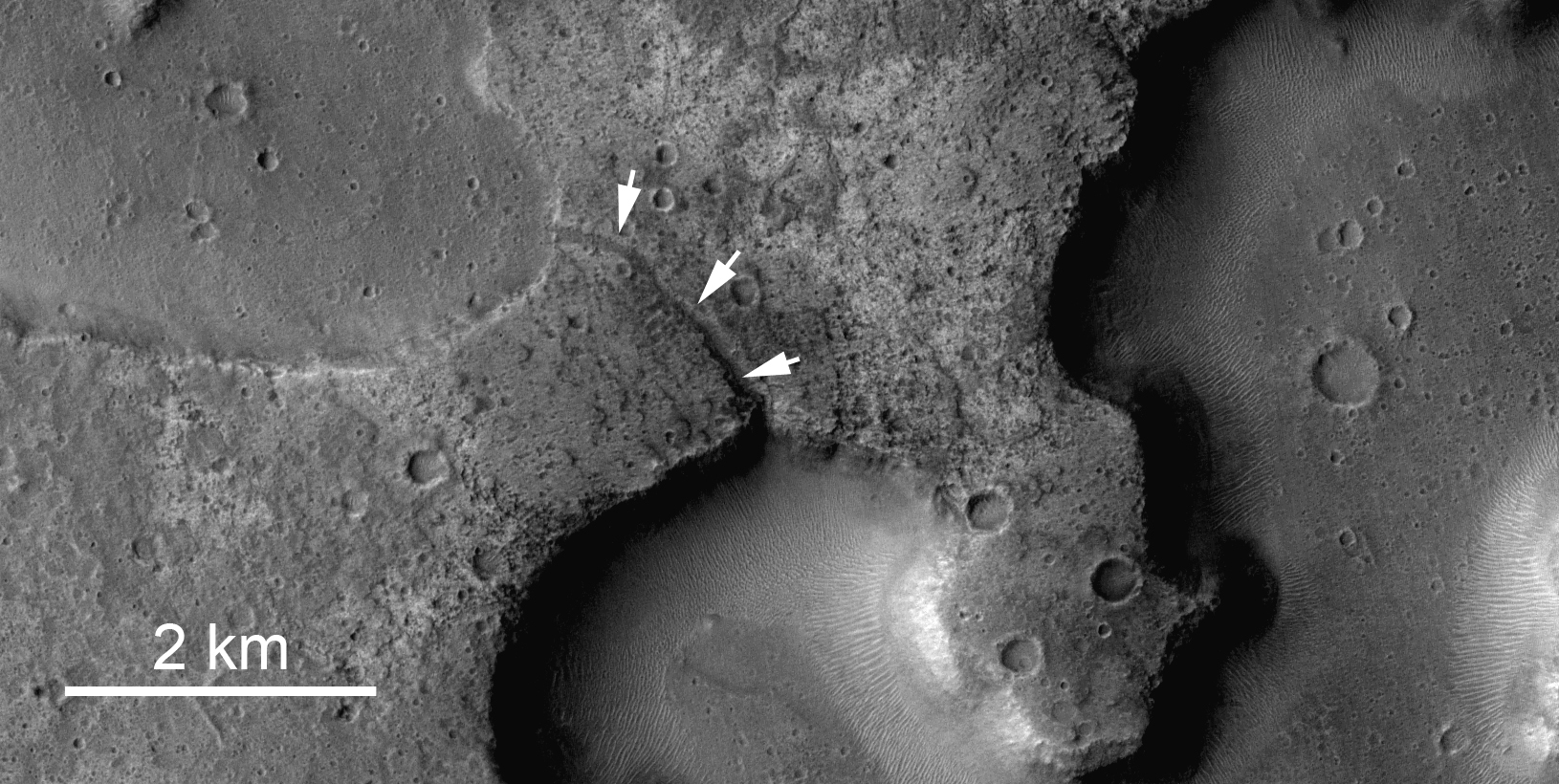
Images of Mars taken from orbit show a massive system of riverbeds and canyons etched by water. Or maybe not. A new study of one channel shows that it was formed by lava flow and not water, and the results make “a strong case that fluid lava can produce channels that look very much like water-generated features,” said Jim Zimbelman from the Smithsonian Institution in Washington, one of the researchers. “So, we should not jump to a water-related conclusion when we see such channels on other planets.”
Whether channels on Mars were formed by water or by lava has been debated for years and the outcome is thought to influence the likelihood of finding life there. Images from various Mars orbiters reveal details resembling the erosion of soil by water: terracing of channel walls, formation of small islands in a channel, hanging channels that dead-end and braided channels that branch off and then reconnect to the main branch. “These are thought to be clear evidence of fluvial [water-based] erosion on Mars,” said Jacob Bleacher from Goddard Spaceflight Center, who presented the results at the Lunar and Planetary Science Conference last week.
Lava flow usually creates big, open channels, such as the ones commonly seen in Hawaii. But detailed looks at both channels on Mars and in Hawaii shed a whole new light on the formation of channels and other features on Mars.
The research team carried out a careful study of a single channel on the southwest flank of Mars’ Ascraeus Mons volcano, one of the three clustered volcanoes collectively called the Tharsis Montes. To piece together images covering more than 270 kilometers (~168 miles) of this channel, the team relied on high-resolution pictures from three cameras—the Thermal Emission Imaging System (THEMIS), the Context Imager (CTX) and the High/Super Resolution Stereo Color (HRSC) imager—as well as earlier data from the Mars Orbiter Laser Altimeter (MOLA). These data gave a much more detailed view of the surface than previously available.
Because the fluid that formed this and other Ascraeus Mons channels is long-gone, its identity has been hard to deduce, but the visual clues at the source of the channel seem to point to water. These clues include small islands, secondary channels that branch off and rejoin the main one and eroded bars on the insides of the curves of the channels. The Tharsis region of Mars, including the three volcanoes of Tharsis Montes (Arsia, Pavonis and Ascraeus Mons), as well as Olympic Mons in the upper left corner. Credit: NASA/Jet Propulsion Lab
But at the channel’s other end, an area not clearly seen before, the team found a ridge that appears to have lava flows coming out of it. In some areas, “the channel is actually roofed over, as if it were a lava tube, and lined up along this, we see several rootless vents,” or openings where lava is forced out of the tube and creates small structures, he explains. These types of features don’t form in water-carved channels, he notes. Bleacher argues that having one end of the channel formed by water and the other end by lava is an “exotic” combination. More likely, he thinks, the entire channel was formed by lava.
To find out what kinds of features lava can produce, Bleacher, Zimbelman and W. Brent Garry examined the 51-kilometer (~32 mile) lava flow from the 1859 eruption of Mauna Loa on the Big Island of Hawaii. Their main focus was an island nearly a kilometer long in the middle of the channel; Bleacher says this is much larger than islands typically identified within lava flows. To survey the island, the team used differential GPS, which provides location information to within about 3 to 5 centimeters (1.1 to 1.9 inches), rather than the roughly 3 to 5 meters (9.8 to 16.4 feet) that a car’s GPS can offer.
“We found terraced walls on the insides of these channels, channels that go out and just disappear, channels that cut back into the main one, and vertical walls 9 meters (~29 feet) high,” Bleacher says. “So, right here, in something that we know was formed only by flowing lava, we found most of the features that were considered to be diagnostic of water-carved channels on Mars.”
Further evidence that such features could be created by lava flows came from the examination of a detailed image of channels from the Mare Imbrium, a dark patch on the moon that is actually a large crater filled with ancient lava rock. In this image, too, the researchers found channels with terraced walls and branching secondary channels.
The conclusion that lava probably made the channel on Mars “not only has implications for the geological evolution of the Ascraeus Mons but also the whole Tharsis Bulge [volcanic region],” says Andy de Wet, a co-author at Franklin & Marshall College, Lancaster, Penn. “It may also have some implications for the supposed widespread involvement of water in the geological evolution of Mars.”
A radar on NASA's Mars Reconnaissance Orbiter has detected widespread deposits of glacial ice in the mid-latitudes of Mars.NASA/JPL-Caltech/ASI/University of Rome/Southwest Research Institute
[/caption]
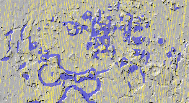
Sure, it’s big news the Moon has water ice on the north pole, but Mars is loaded! A new extensive radar mapping of the middle-latitude region of northern Mars shows that thick masses of buried ice are quite common beneath the surface. The Mars Reconnaissance Orbiter’s Shallow Radar instrument has detected subsurface ice deposits that extend for hundreds of kilometers in the rugged region called Deuteronilus Mensae, about halfway from the equator to the Martian north pole. “We have mapped the whole area with a high density of coverage,” said Jeffrey Plaut from JPL. “These are not isolated features. In this area, the radar is detecting thick subsurface ice in many locations.”
The Shallow Radar instrument has been charting the locations of these hidden glaciers and ice-filled valleys, finding that the most common locations are around the bases of mesas and scarps, and confined within valleys or craters. After obtaining more than 250 observations of the study area, which is about the size of California, the science team is beginning to understand how these deposits may have been left as remnants when regional ice sheets retreated.
“The hypothesis is the whole area was covered with an ice sheet during a different climate period, and when the climate dried out,” Plaut said, “these deposits remained only where they had been covered by a layer of debris protecting the ice from the atmosphere.”
These buried masses of ice are a significant fraction of the known non-polar ice on Mars. The ice could contain a record of environmental conditions at the time of its deposition and flow, making the ice masses an intriguing possible target for a future mission with digging capability.
MRO will continue mapping the area to provide more insight into the buried ice.
Image of a channel between putative lakes from the Context Camera (CTX) onboard NASA’s Mars Reconnaissance Orbiter (MRO).
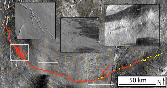
Modern Mars is frigid and dry, but new evidence suggests that in some locations on the equator there may have been lakes as recently as 3 billion years ago.
Researchers from Imperial College London and University College London studied images from the context camera (CTX) on NASA’s Mars Reconnaissance Orbiter (MRO) of several flat-floored depressions in Ares Vallis, near the martian equator.
Previously these depressions were thought to be due to the collapse of the surface as ground ice sublimated directly to gas, but CTX images reveal small channels connecting the depressions, suggesting that water flowed between them. Similar features can be found in “thermokarst” landscapes in Alaska and elsewhere, where permafrost is melting to create lakes and streams.
To determine the age of the features, the scientists counted more than 35,000 craters in the area. Assuming that the current surface was continuously exposed to impacts from space since it was emplaced, the density of craters points to an age of roughly three billion years.
Previously, it was thought that Mars dried up between 4 and 3.8 billion years ago, but if the cratering age from this study is correct, these new results suggest at least brief periods later in martian history when lakes could exist.
The lead author, Dr Nicholas Warner, from the Department of Earth Science and Engineering at Imperial College London, said: “Most of the research on Mars has focused on its early history and the recent past. Scientists had largely overlooked the Hesperian Epoch as it was thought that Mars was then a frozen wasteland. Excitingly, our study now shows that this middle period in Mars’ history was much more dynamic than we previously thought.”
It is not clear how long-lived the lakes were, but Warner and colleagues suggest that they may have served as oases for life in an otherwise inhospitable world. They also suggest that these lakes would be an interesting landing site for future robotic missions.
What’s the next step? The researchers plan to study other equatorial areas, including the mouth of Ares Vallis and Chryse Planitia to see how widespread the putative lakes were.

 Active Dune Gullies in Kaiser Crater. Credit: NASA/JPL/University of Arizona")


 CTX close-up (image B01_009932_2370). CRISM mineral maps from observations FRT0000BAD4 and FRT0000C63C are overlaid in red (smectites or chlorite-prehnite) and green (olivine). The white dashed lines indicate the boundaries of the two adjacent observations. (C) HiRISE close-up (image PSP006860_2370) overlain by CRISM mineral maps. No HiRISE data are available over the chlorite-prehnite unit. Image courtesy of Science/AAAS")
 CTX closeup (image P20_008686_2356). CRISM mineral maps from observation FRT0000ADA4 are overlain in color. The white dashed lines indicate the boundaries of the CRISM observation. (C) HiRISE close-up (image PSP_009332_2360) of the Al-phyllosilicate “montmorillonite”-bearing unit. The sources of the material are the bright outcrops near the scarp summit (right), whereas the light-toned unit (left) is material transported downslope. (D) HiRISE close-up (image PSP_009332_2360) showing outcrops of olivine, Fe/Mg-, and Al-phyllosilicates in close spatial association. Image courtesy of Science/AAAS")

 and at the location of the Seminole outcrop. Spirit is currently located on the left side of Home Plate. Image width is ~1000 m. Image courtesy of NASA/UA/HiRISE using PSP_001513_1655_red image. After Arvidson et al. [2008]")