Opportunity Phones Home Dusty Self-Portraits and Ground Breaking Science

Mosaic: NASA/JPL/Cornell/ASU/Marco Di Lorenzo/Kenneth Kremer

[/caption]

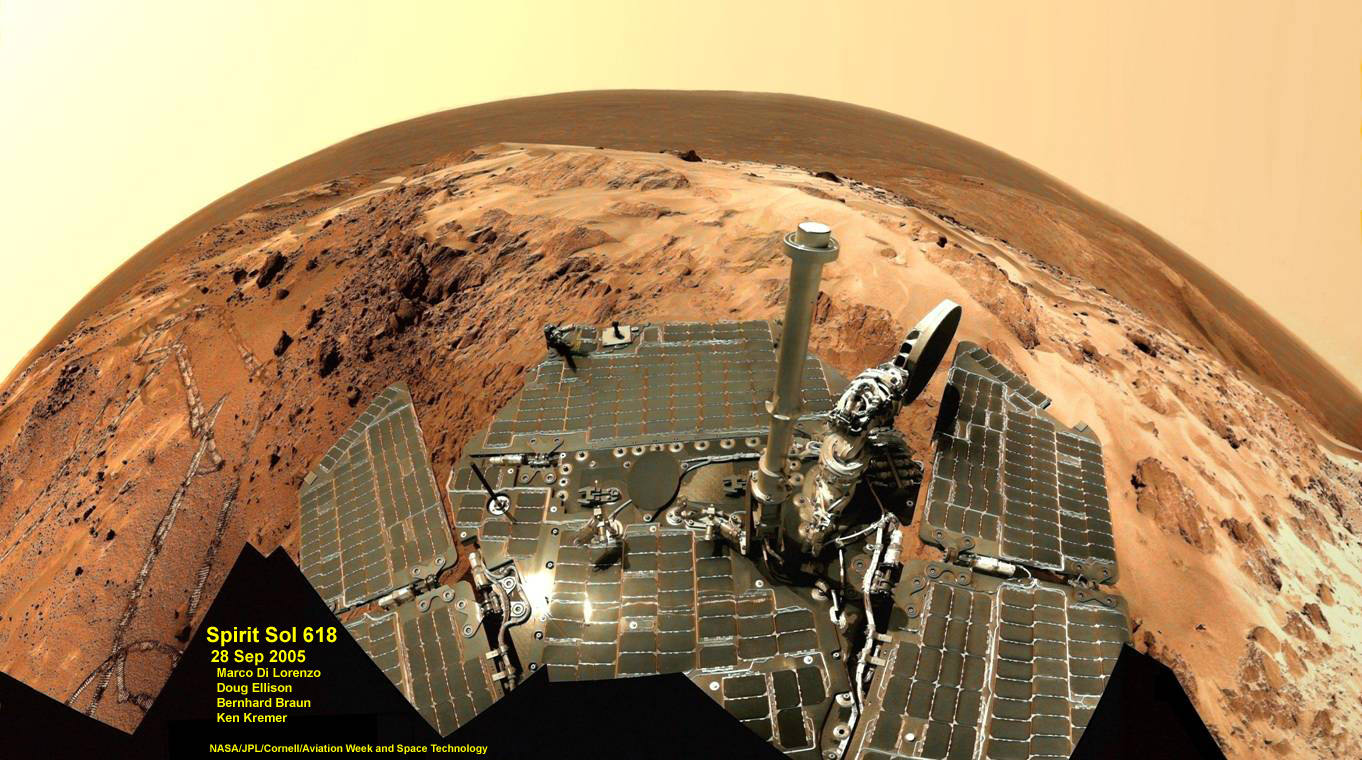
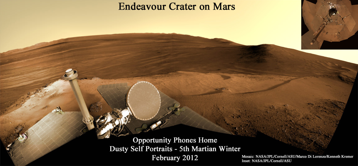
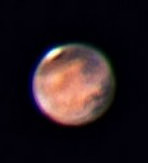
Opportunity, the Princess of Martian Robots, phoned home dusty new self portraits – above and below – of her beautiful bod basking in the utterly frigid sunshine during her 5th winter on the Red Planet whilst overlooking a humongous crater offering bountiful science.

NASA’s endearing robot is simultaneously carrying out an ambitious array of ground breaking science experiments this winter – providing insight into the mysterious nature of the Martian core – while sitting stationary until the energy augmenting rays of the springtime Sun shower down on Mars from the heavens above.

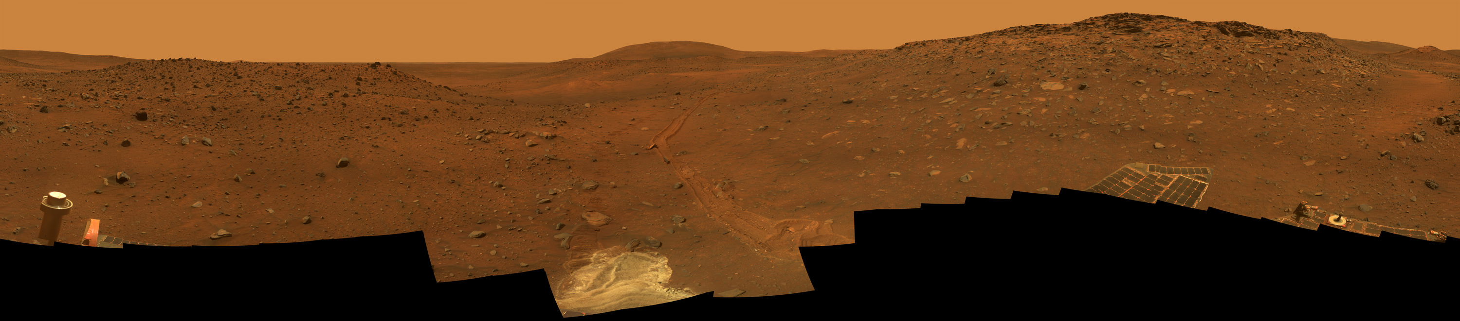
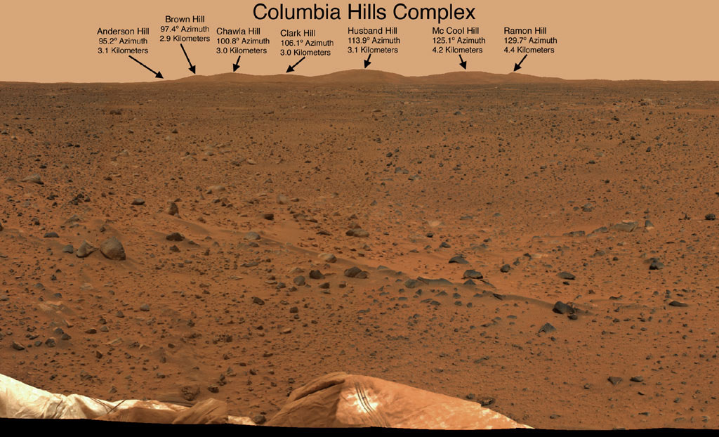
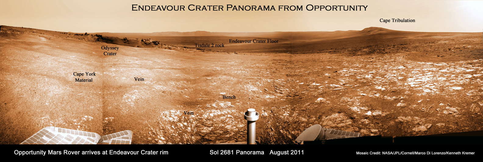
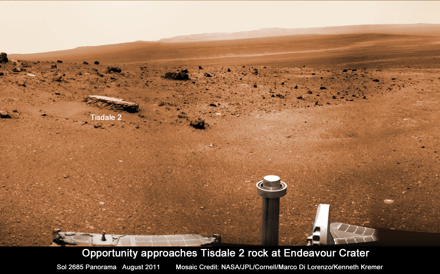
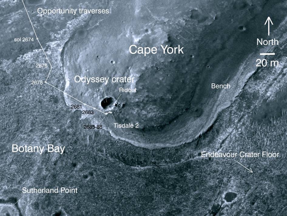
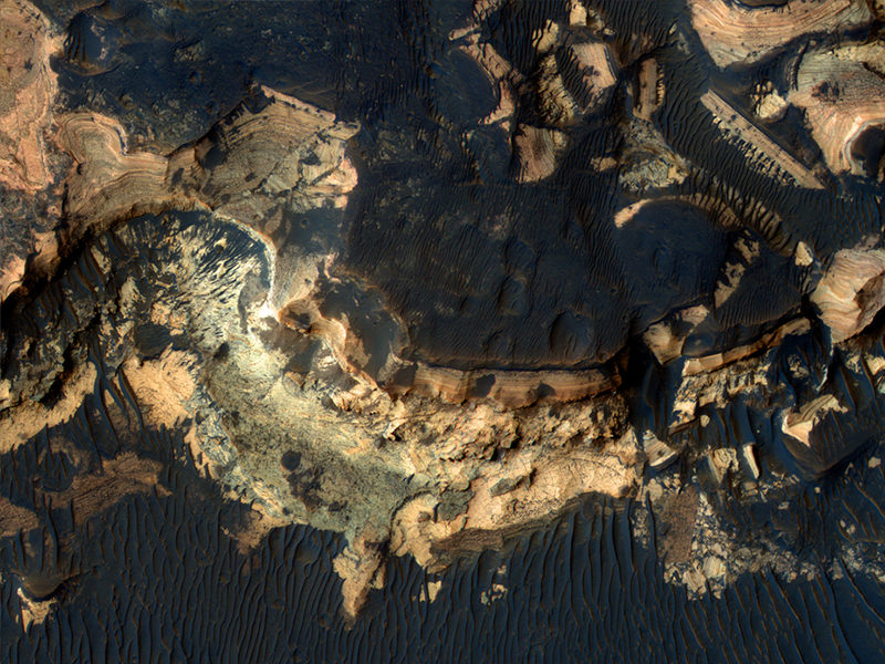
Opportunity’s current winter worksite is located at the rim of the vast crater named Endeavour, some 14 miles (22 kilometers) in diameter. The robot will remain parked for the winter on a slope at the north end of the crater rim segment called Cape York with an approximate 15-degree northerly tilt towards the life-giving sun to maximize solar energy production. The park-site is at an outcrop dubbed “Greeley Haven”, named in honor of Ronald Greeley, a beloved and recently deceased science team member.

The power killing dust buildup is readily apparent on the solar arrays and High Gain Antenna pictured in the new panoramic self-portraits of Opportunity’s wing-like deck. The red Martian dust also functions as a rather effective camouflage agent, sometimes blending the rover to near invisibility with the surface.

Dusty Mars Rover's Self-Portrait- Dec 2011
NASA's Mars Exploration Rover Opportunity shows dust accumulation on the rover's solar panels as the mission approached its fifth Martian winter at the rim of Endeavour Crater. Opportunity is located on the north-facing slope of a site called "Greeley Haven." This is a mosaic of images taken by Opportunity's panoramic camera (Pancam) during the 2,811th to 2,814th Martian days, or sols, of the rover's mission (Dec. 21 to Dec. 24, 2011). Credit: NASA/JPL-Caltech/Cornell/Arizona State Univ.

Indeed because Opportunity is covered with a thicker film of dust compared to her prior four Martian winters, the rover team was forced to employ the same “tilting” strategy they successfully used to keep her twin sister Spirit alive during her trio of Antarctic-like winters. This is the first winter that Opportunity did not have sufficient power to continue roving across the surface.

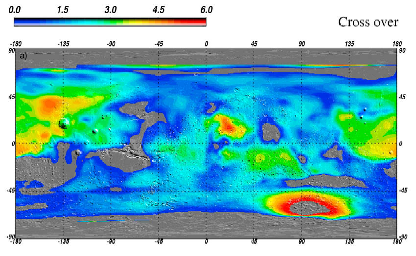
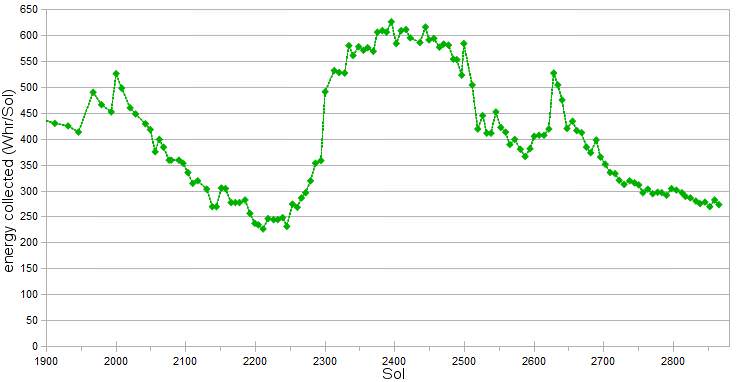
Since Opportunity is located just south of the Martian equator, the daylight hours for solar power generation are growing shorter until the southern Mars winter solstice occurs on March 30, 2012. As of mid- February 2012, the latest measure of solar array energy production was 274 watt-hours, compared to about 900 watt-hours at the start of the mission. See Solar Power energy graph below.

Power generation from the solar arrays has fluctuated up and down throughout Opportunity’s lifetime depending on when the completely unpredictable and fortuitous Martian wind storms chance by and miraculously clean the arrays of the rusty red dust.

Opportunity Rover Self-Portrait From 2007
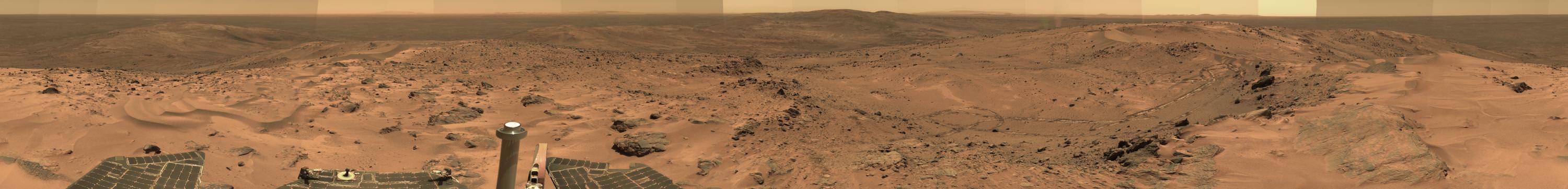
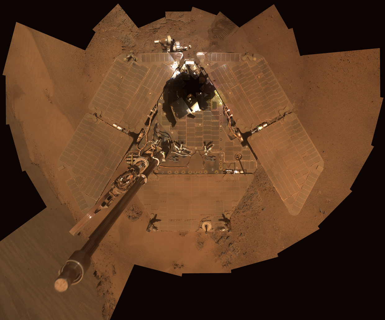
Opportunity used its panoramic camera (Pancam) during the mission's sols 1282 and 1284 (Sept. 2 and Sept. 4, 2007) to take the images combined into this mosaic view of the rover. The downward-looking view omits the mast on which the camera is mounted.The deck panorama is presented in approximate true color, the camera team's best estimate of what the scene would look like if humans were there and able to see it with their own eyes.Credit: NASA/JPL-Caltech/Cornell

The rover science team is ingeniously using the lack of movement to their advantage and Opportunity is still vigorously hard at work doing breakthrough research each and every day.

From her stationary position, Opportunity is conducting her first ever radio science Doppler tracking measurements to support geo-dynamic investigations and to elucidate the unknown structure of the Martian interior and core. The team was eager for the long awaited chance to carry out the radio tracking experiment with the High Gain Antenna (HGA) and determine if Mars core is liquid or solid. Months of data collection are required while the rover stays stationary.

“This winter science campaign will feature two way radio tracking with Earth to determine the Martian spin axis dynamics – thus the interior structure, a long-neglected aspect of Mars,” Ray Arvidson told Universe Today. Arvidson, of Washington University in St. Louis, is the deputy rover Principal Investigator.

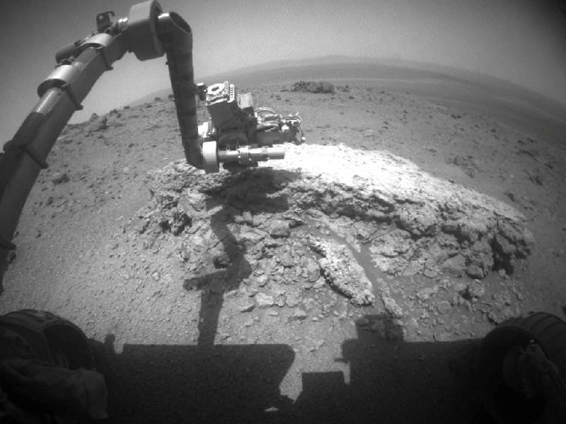
Opportunity has nearly finished snapping the 13 filter, 360 degree stereo Greeley” panorama. The rover deployed the robotic arm onto the surface of the “Amboy” outcrop to collect multi-sol integrations with the Mössbauer Spectrometer and the largest ever mosaic campaign using the Microscopic Imager.

“We’ll do good science while we’re at Greeley Haven. But as soon as we catch a wind gust or the seasons change, we’ll be on our way again,” Steve Squyres told Universe Today. Squyres, of Cornell University is the rover Science Principal Investigator

“The Martian southern winter solstice occurs at the end of March. A few months after that date we will drive her off the outcrop and further explore Cape York,” Arvidson told me

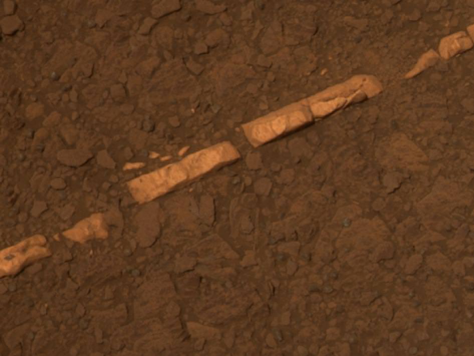
The team will drive Opportunity in search of further evidence of the gypsum mineral veins like “Homestake” – indicative of ancient water flow – previously discovered at Cape York. Thereafter they’ll rove further south to investigate deposits of phyllosilicates, the clay minerals which stem from an earlier epoch when liquid water flowed on Mars eons ago and perhaps may have been more favorable to sustaining life.

Graph shows Opportunity’s Solar power energy generation over the past 1000 Sols, or Martian Days, from Sol 1900 up to February 2012. Credit: NASA/JPL/Marco Di Lorenzo

Mars from Earth on Feb 18, 2012 is nearly at opposition (occurs March 3) in this image taken using a Celestron 11 inch telescope in Leesburg, Florida. Astrophotographer Credit: Ernie Rossi

Opportunity is now well into her 9th year exploring hitherto unknown terrain on Mars, far exceeding anyone’s expectation. She landed inside a tiny crater on Jan. 24. 2004 for what was expected to be a mission of merely 90 Martian days, or Sols.

Today is Martian Sol 2873, that’s 32 times beyond the rover designers “warranty” for NASA’s Opportunity rover.

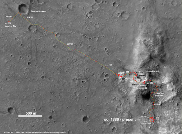
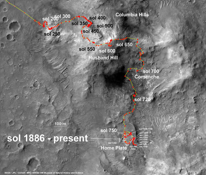
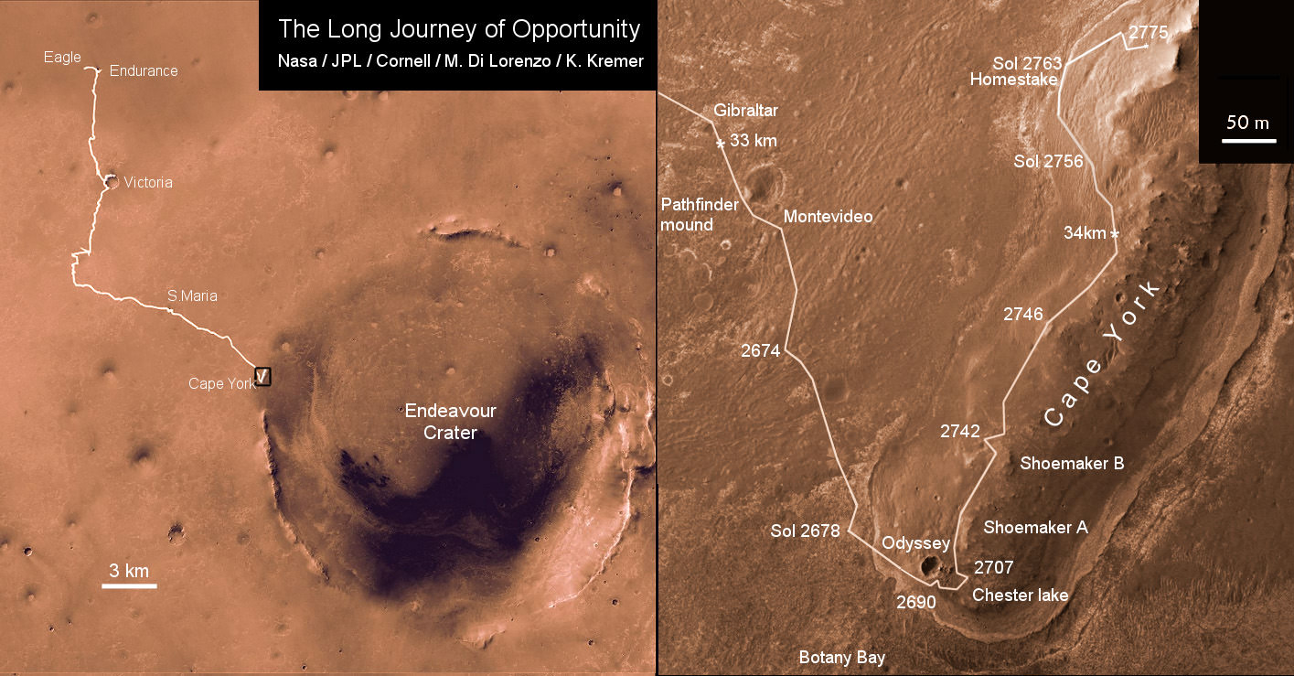
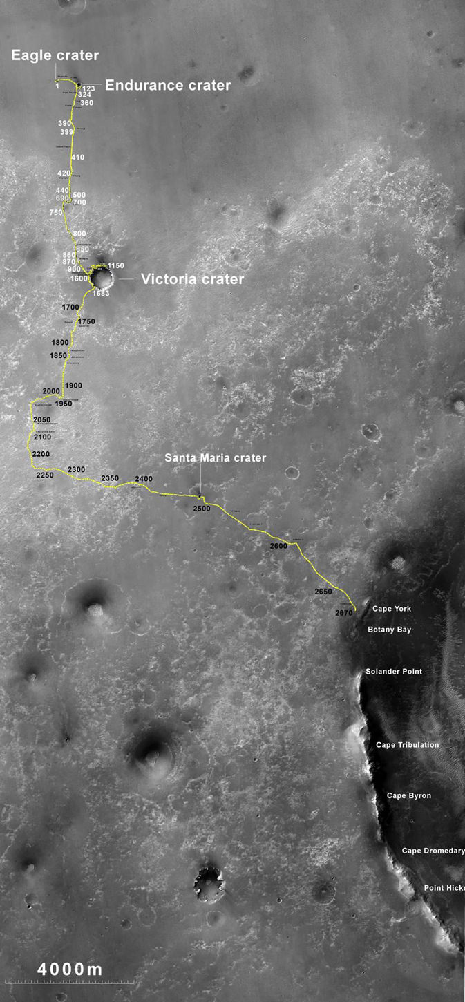
Altogether, Opportunity has journeyed more than 21 miles (34 kilometers) across the Red Planet’s surface, marking the first overland expedition on another Planet. See our route map below.

Opportunity Rover Traverse Map at Meridiani Planum on Mars - 2004 to 2012
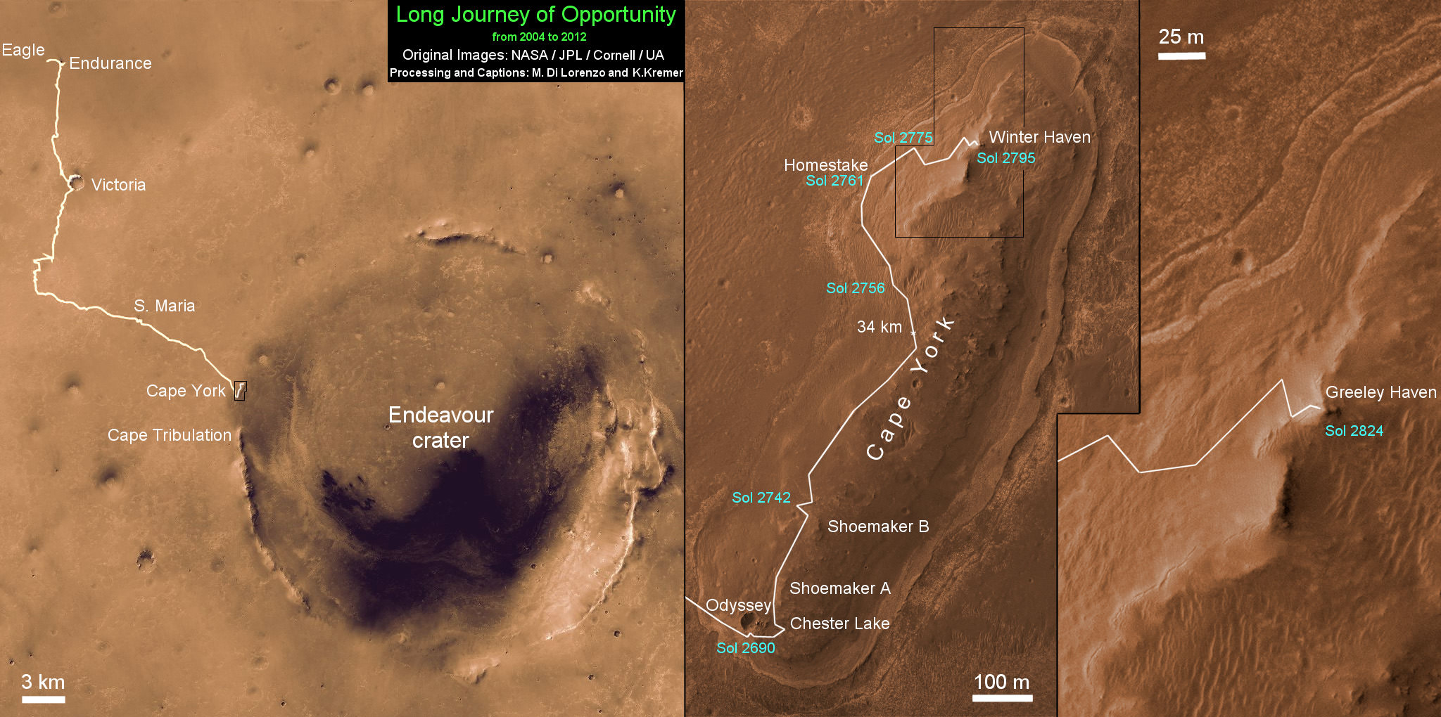
Traverse map shows the 8 Year Journey of Opportunity from Eagle Crater landing site on Sol 1- Jan. 24, 2004 - to 5th Winter Haven worksite at Greeley Haven at Endeavour Crater rim in January 2012. Opportunity embarked on a crater tour and discovered bountiful evidence for the flow of liquid water on Mars billions of years ago. Endeavour Crater is 14 miles 22 kilometers) in diameter. Opportunity has driven more than 21 miles (34 km). Credit: NASA/JPL/Cornell/UA/Marco Di Lorenzo/Kenneth Kremer

Meanwhile, NASA’s Curiosity Mars Science Laboratory rover is rocketing through space and on course for a pinpoint touchdown inside the layered terrain of Gale Crater on August 6, 2012. Curiosity is now America’s last planned Mars rover following the cancellation of the joint NASA/ESA ExoMars rover mission in the Obama Administrations newly announced Fiscal 2013 NASA budget.

Large Amounts of Water Ice Found Underground on Mars

Global map of Water ice on Mars
New estimates of water ice on Mars suggest there may be large reservoirs of underground ice at non-polar latitudes. The map here shows "water-equivalent hydrogen". Oranges and reds on the map (values greater than 4.5 weight % water-equivalent hydrogen at the surface) point out areas where the amount of deeply buried water ice is greater than what can fit in the pore spaces of the surface rocks. Image credit: Feldman et al., 2011

[/caption]

Many models predict that water ice shouldn’t be stable on Mars today, anywhere beyond the poles, no matter how deep you bury it. And yet, a recently published study shows that large regions outside the polar areas may, in fact, contain a relative abundance of water. This is exciting, not only because water has implications for the possibility of life on Mars, but also because it can provide a valuable resource to future explorers, both as a fuel and for life support. And if this water is near the equator, that makes it much easier to get to.

Over the past 7 years, lots of spacecraft observations have given us evidence for the presence of water on Mars, either at the surface or not far below. Radar data have shown that large amounts of water ice are stored at the poles (Lots of Pure Water Ice at Mars North Pole). And pictures of gullies have hinted at reserves of water beneath the surface (NASA Says Liquid Water Made Martian Gullies). Now, a team of scientists, led by Dr. William Feldman of the Planetary Science Institute in Tucson, Arizona, have taken a new look at some of that data.

Dr. Feldman and his team used data from the Mars Odyssey Neutron Spectrometer (MONS) to estimate the amount of water ice that is present outside of the polar regions of Mars, where water ice is not expected to be found. The MONS is an instrument that counts Martian neutrons from orbit. These “neutron counts” are sensitive to the presence of hydrogen and how deep it is below the surface. Using models that take the characteristics of the Martian surface and the relationship of hydrogen to water into account, the MONS data can be used to predict the amount and depth of water and water ice in the surface. Doing just that, Dr. Feldman’s team produced a nearly global map of potential underground ice deposits.

Global map of Water ice on Mars
New estimates of water ice on Mars suggest there may be large reservoirs of underground ice at non-polar latitudes. The map here shows "water-equivalent hydrogen". Oranges and reds on the map (values greater than 4.5 weight % water-equivalent hydrogen at the surface) point out areas where the amount of deeply buried water ice is greater than what can fit in the pore spaces of the surface rocks.
Image credit: Feldman et al., 2011.

This map shows the “weight percent of water-equivalent hydrogen”, or how much of the rock’s weight comes from hydrogen that is bound up in water molecules. Since hydrogen atoms are much lighter than the other atoms that make up a rock, a small weight percent of hydrogen equals a much larger volume of water ice. In fact, Dr. Feldman’s team estimate that values of 4.5 weight % hydrogen or greater (oranges and reds on the map), mean the volume of water ice at depth is larger than what can fit into pore spaces (the spaces between the grains that make up a rock). This means that you no longer have ice in a rock; now you have rocks in ice!

Four regions containing such bulk ice stand out in the map: Promethei Terra in the lower right of the map, Arabia Terra in the upper centre, Arcadia Planitia in the upper left, and Elysium Planetia spanning from the centre right, across the Martian “date line” (180 degrees longitude), to the centre left of the map. The ice deposits here are “buried less than about 1 m below the surface,” writes Dr. Feldman. He does admit that their findings may also indicate the presence of large quantities of minerals that contain water molecules in their chemical make-up. However, their results are supported by other evidence. In the Elysium Planetia region, evidence of glacial features has been seen in high resolution stereo data from ESA’s Mars Express orbiter ( Mars Express Reveals Possible Martian Glaciers). And in the Arcadia Planitia region, buried water ice has been identified in CRISM data, where an almost pure ice layer was excavated from less than 1 meter below the surface by four recent impact events.

Ice ejecta around Martian crater
Almost pure water ice is seen in the ejecta surrounding this impact crater (8 meters in diameter), which formed in 2008. The only reason we can see ice at the surface here is because this crater is so young. As time passes, the ice will all sublimate away.
Image Credit: High Resolution Imaging Science Experiment camera, NASA/JPL-Caltech/University of Arizona.

So, if ice is unstable at today’s conditions on Mars, how can Dr. Feldman and his team account for the presence of that much ice so close to the surface? Well, the bulk ice could have been deposited some 10-20 million years ago, at a time when ice was stable at the surface. If that happened, then the ice sheet could have been preserved under a layer of cemented dust and sediment. This duricrust would have partially shielded the ice from contemporary surface temperatures and atmospheric conditions, slowing the sublimation of the ice just enough so that some of it was left for us to detect today.

Source Link: Feldman et al., 2011, JGR 116, E11009

8 Years of Spirit on Mars – Pushing as Hard as We Can and Beyond !

Spirit Mars rover - view from Husband Hill summit. Spirit snapped this view self portrait from the summit of Husband Hill inside Gusev crater on Sol 618 on 28 September 2005. The rovers were never designed or intended to climb mountains. It took more than 1 year for Spirit to scale the Martian mountain. This image was created by an international team of astronomy enthusiasts and appeared on the cover of the 14 November 2005 issue of Aviation Week & Space Technology magazine and the April 2006 issue of Spaceflight magazine. Also selected by Astronomy Picture of the Day (APOD) on 28 November 2005. Credit: Marco Di Lorenzo, Douglas Ellison, Bernhard Braun and Kenneth Kremer. NASA/JPL/Cornell/Aviation Week & Space Technology

[/caption]

January 2012 marks the 8th anniversary since of the daring landing’s of “Spirit” and “Opportunity”NASA’s now legendary twin Mars Exploration Rovers (MER), on opposite sides of the Red Planet in January 2004. They proved that early Mars was warm and wet – a key finding in the search for habitats conducive to life beyond Earth.

I asked the leaders of the MER team to share some thoughts celebrating this mind-boggling milestone of “8 Years on Mars” and the legacy of the rovers for the readers of Universe Today. This story focuses on Spirit, first of the trailblazing twin robots, which touched down inside Gusev Crater on Jan. 3, 2004. Opportunity set down three weeks later on the smooth hematite plains of Meridiani Planum.

“Every Sol is a gift. We push the rovers as hard as we can,” Prof. Steve Squyres informed Universe Today for this article commemorating Spirit’s landing. Squyres, of Cornell University, is the Scientific Principal Investigator for the MER mission.

“I seriously thought both Spirit and Opportunity would be finished by the summer of 2004,” Ray Arvidson told Universe Today. Arvidson, of Washington University in St. Louis, is the deputy principal investigator for the MER rovers.

'Calypso' Panorama of Spirit's View from 'Troy'
This full-circle view from the panoramic camera (Pancam) on NASA's Mars Exploration Rover Spirit shows the terrain surrounding the location called "Troy," where Spirit became embedded in soft soil during the spring of 2009. The hundreds of images combined into this view were taken beginning on the 1,906th Martian day (or sol) of Spirit's mission on Mars (May 14, 2009) and ending on Sol 1943 (June 20, 2009). Credit: NASA/JPL-Caltech/Cornell University
click to enlarge

Spirit endured for more than six years and Opportunity is still roving Mars today !

The dynamic robo duo were expected to last a mere three months, or 90 Martian days (sols). In reality, both robots enormously exceeded expectations and accumulated a vast bonus time of exploration and discovery in numerous extended mission phases.

Spirit survived three harsh Martian winters and only succumbed to the Antarctic-like temperatures when she unexpectedly became mired in an unseen sand trap driving beside an ancient volcanic feature named ‘Home Plate’ that prevented the solar arrays from generating life giving power to safeguard critical electronic and computor components.

Spirit was heading towards another pair of volcanic objects named von Braun and Goddard and came within just a few hundred feet when she died.

Everest Panorama from Husband Hill summit
It took Spirit three days, sols 620 to 622 (Oct. 1 to Oct. 3, 2005), to acquire all the images combined into this mosaic, called the "Everest Panorama". Credit: NASA/JPL-Caltech/Cornell University
Click to enlarge

“I never thought that we would still be planning sequences for Opportunity today and that we only lost Spirit because of her limited mobility and bad luck of breaking through crusty soil to get bogged down in loose sands,” said Arvidson

By the time of her last dispatch from Mars in March 2010, Spirit had triumphantly traversed the red planets terrain for more than six years of elapsed mission time – some 25 times beyond the three month “warranty” proclaimed by NASA as the mission began back in January 2004.

The "Columbia Hills" in Gusev Crater on Mars
Husband Hill is 3.1 kilometers distant. Spirit took this mosaic of images with the panoramic camera at the beginning of February, 2004, less than a month after landing on Mars. Image credit: NASA/JPL-Caltech/Cornell

“I am feeling pretty good as the MER rover anniversaries approach in that Spirit had an excellent run, helping us understand without a doubt that early Mars had magmatic and volcanic activity that was “wet”, Arvidson explained.

“Magmas interacted with ground water to produce explosive eruptions – at Home Plate, Goddard, von Braun – with volcanic constructs replete with steam vents and perhaps hydrothermal pools.”

Altogether, the six wheeled Spirit drove over 4.8 miles (7.7 kilometers) and the cameras snapped over 128,000 images. NASA hoped the rovers would drive about a quarter mile during the planned 90 Sol mission.

“Milestones like 8 years on Mars always make me look forward rather than looking back,” Squyres told me.

Carbonate-Containing Martian Rocks discovered by Spirit Mars Rover
Spirit collected data in late 2005 which confirmed that the Comanche outcrop contains magnesium iron carbonate, a mineral indicating the past environment was wet and non-acidic, possibly favorable to life. This view was captured during Sol 689 on Mars (Dec. 11, 2005). The find at Comanche is the first unambiguous evidence from either Spirit or Opportunity for a past Martian environment that may have been more favorable to life than the wet but acidic conditions indicated by the rovers' earlier finds. Credit: NASA/JPL-Caltech/Cornell University

Spirit became the first robotic emissary from humanity to climb a mountain beyond Earth, namely Husband Hill, a task for which she was not designed.

“No one expected the rovers to last so long,” said Rob Manning to Universe Today. Manning, of NASA’s Jet Propulsion laboratory, Pasadena, CA. was the Mars Rover Spacecraft System Engineering team lead for Entry, Descent and Landing (EDL)

“Spirit surmounted many obstacles, including summiting a formidable hill her designers never intended her to attempt.”

“Spirit, her designers, her builders, her testers, her handlers and I have a lot to be thankful for,” Manning told me.

After departing the Gusev crater landing pad, Spirit traversed over 2 miles to reach Husband Hill. In order to scale the hill, the team had to create a driving plan from scratch with no playbook because no one ever figured that such a mouthwatering opportunity to be offered.

Spirit Rover traverse map from Gusev Crater landing site to Home Plate: 2004 to 2011

It took over a year to ascend to the hill’s summit. But the team was richly rewarded with a science bonanza of evidence for flowing liquid water on ancient Mars.

Spirit then descended down the other side of the hill to reach the feature dubbed Home Plate where she now rests and where she found extensive evidence of deposits of nearly pure silica, explosive volcanism and hot springs all indicative of water on Mars billions of years ago.

“Spirit’s big scientific accomplishments are the silica deposits at Home Plate, the carbonates at Comanche, and all the evidence for hydrothermal systems and explosive volcanism, Squyres explained. “ What we’ve learned is that early Mars at Spirit’s site was a hot, violent place, with hot springs, steam vents, and volcanic explosions. It was extraordinarily different from the Mars of today.”

“We’ve still got a lot of exploring to do [with Opportunity], but we’re doing it with a vehicle that was designed for a 90-sol mission,” Squyres concluded. “That means that ever sol is a gift at this point, and we have to push the rover and ourselves as hard as we can.”

NASA concluded the last attempt to communicate with Spirit in a transmission on May 25, 2011.

Spirit Rover traverse map from Husband Hill to resting place at Home Plate: 2004 to 2011
The Last View Ever from Spirit rover on Mars
Spirit’s last panorama from Gusev Crater was taken during February 2010 before her death from extremely low temperatures during her 4th Martian winter. Spirit was just 500 feet from her next science target - dubbed Von Braun – at center, with Columbia Hills as backdrop.
Mosaic Credit: Marco De Lorenzo/ Kenneth Kremer/ NASA/JPL/Cornell University
Mosaic featured on Astronomy Picture of the Day (APOD) on 30 May 2011 - http://apod.nasa.gov/apod/ap110530.html

Meanwhile, the Curiosity Mars Science Lab rover, NASA’s next Red Planet explorer, continues her interplanetary journey on course for a 6 August 2012 landing at Gale Crater.

Read continuing features about the Mars Rovers, Curiosity and GRAIL by Ken Kremer here:
Two new Moons join the Moon – GRAIL Twins Achieve New Year’s Orbits
2011: Top Stories from the Best Year Ever for NASA Planetary Science!
Opportunity Discovers Most Powerful Evidence Yet for Martian Liquid Water
Curiosity Starts First Science on Mars Sojurn – How Lethal is Space Radiation to Life’s Survival

Jan 11: Free Lecture by Ken Kremer at the Franklin Institute, Philadelphia, PA at 8 PM for the Rittenhouse Astronomical Society. Topic: Mars & Vesta in 3 D – Plus Search for Life & GRAIL

Opportunity Discovers Most Powerful Evidence Yet for Martian Liquid Water

Opportunity discovers Water related mineral vein at Endeavour Crater - November 2011. Opportunity rover discovered Gypsum at the Homestake mineral vein, while exploring around the base of Cape York ridge at the rim of Endeavour Crater. The vein is composed of calcium sulfate and indicates the ancient flow of liquid water at this spot on Mars. Opportunity drove North (ahead) from here in search of a sunny winter haven. Credit: NASA/JPL/Cornell/Kenneth Kremer/Marco Di Lorenzo

[/caption]

NASA’s long lived Opportunity rover has discovered the most scientifically compelling evidence yet for the flow of liquid water on ancient Mars. The startling revelation comes in the form of a bright vein of the mineral gypsum located at the foothills of an enormous crater named Endeavour, where the intrepid robot is currently traversing. See our mosaic above, illustrating the exact spot.

Update: ‘Homestake’ Opportunity Mosaic above has just been published on Astronomy Picture of the Day (APOD) – 12 Dec 2011 (by Ken Kremer and Marco Di Lorenzo)

Researchers trumpeted the significant water finding this week (Dec. 7) at the annual winter meeting of the American Geophysical Union (AGU) in San Francisco.

“This gypsum vein is the single most powerful piece of evidence for liquid water at Mars that has been discovered by the Opportunity rover,” announced Steve Squyres of Cornell University, Ithaca, N.Y., Principal Investigator for Opportunity, at an AGU press conference.

The light-toned vein is apparently composed of the mineral gypsum and was deposited as a result of precipitation from percolating pools of liquid water which flowed on the surface and subsurface of ancient Mars, billions of years ago. Liquid water is an essential prerequisite for life as we know it.

“This tells a slam-dunk story that water flowed through underground fractures in the rock,” said Squyres. “This stuff is a fairly pure chemical deposit that formed in place right where we see it. That can’t be said for other gypsum seen on Mars or for other water-related minerals Opportunity has found. It’s not uncommon on Earth, but on Mars, it’s the kind of thing that makes geologists jump out of their chairs.”

'Homestake' Vein in Color and Close-up
This color view of a mineral vein called "Homestake" was taken by the panoramic camera (Pancam) on NASA's Mars Exploration Rover Opportunity. The vein is about the width of a thumb and about 18 inches (45 centimeters) long. Opportunity examined it in November 2011 and found it to be rich in calcium and sulfur, possibly the calcium-sulfate mineral gypsum.

The light-toned vein is informally named “Homestake”, and was examined up close by Opportunity’s cameras and science instruments for several weeks this past month in November 2011, as the rover was driving northwards along the western edge of a ridge dubbed ‘Cape York’ – which is a low lying segment of the eroded rim of Endeavour Crater.

Veins are a geologic indication of the past flow of liquid water

Opportunity just arrived at the rim of the 14 mile (22 kilometere) wide Endeavour Crater in mid-August 2011 following an epic three year trek across treacherous dune fields from her prior investigative target at the ½ mile wide Victoria Crater.

“It’s like a whole new mission since we arrived at Cape York,” said Squyres.

‘Homestake’ is a very bright linear feature.

“The ‘Homestake’ vein is about 1 centimeter wide and 40 to 50 centimeters long,” Squyres elaborated. “It’s about the width of a human thumb.”

Opportunity's Approach to 'Homestake'
This view from the front hazard-avoidance camera on NASA's Mars Exploration Rover Opportunity shows the rover's arm's shadow falling near a bright mineral vein informally named Homestake. The vein is about the width of a thumb and about 18 inches (45 centimeters) long. Opportunity examined it in November 2011 and found it to be rich in calcium and sulfur, possibly the calcium-sulfate mineral gypsum. Opportunity took this image on Sol 2763 on Mars (Nov. 7, 2011). Credit: NASA/JPL-Caltech

Homestake protrudes slightly above the surrounding ground and bedrock and appears to be part of a system of mineral veins running inside an apron (or Bench) that in turn encircles the entire ridge dubbed Cape York.

In another first, no other veins like these have been seen by Opportunity throughout her entire 20 miles (33 kilometers) and nearly eight year long Martian journey across the cratered, pockmarked plains of Meridiani Planum, said Squyres.

The veins have also not been seen in the higher ground around the rim at Endeavour crater.

“We want to understand why these veins are in the apron but not out on the plains,” said the mission’s deputy principal investigator, Ray Arvidson, of Washington University in St. Louis. “The answer may be that rising groundwater coming from the ancient crust moved through material adjacent to Cape York and deposited gypsum, because this material would be relatively insoluble compared with either magnesium or iron sulfates.”

Opportunity was tasked to engage her Microscopic Imager and Alpha Particle X-ray Spectrometer (APXS) mounted on the terminus of the rover’s arm as well as multiple filters of the mast mounted Panoramic Camera to examine ‘Homestake’.

“The APXS spectrometer shows ’Homestake’ is chock full of Calcium and Sulfur,” Squyres gushed.

Microscopic Close-up View of 'Homestake' Vein
This close-up view of a mineral vein called Homestake comes from the microscopic imager on Opportunity. The vein is about the width of a thumb and about 18 inches (45 centimeters) long. Opportunity examined it in November 2011 and found it to be rich in calcium and sulfur, possibly the calcium-sulfate mineral gypsum. Homestake is near the edge of the "Cape York" segment of the western rim of Endeavour Crater. This view blends three exposures taken by the microscopic imager during the 2,765th and 2,766th Martian days, or sols, of Opportunity's career on Mars (Nov. 3 and 4, 2011). Credit: NASA/JPL-Caltech/Cornell/USGS

The measurements of composition with the APXS show that the ratio points to it being relatively pure calcium sulfate, Squyres explained. “One type of calcium sulfate is gypsum.”

Calcium sulfate can have varying amounts of water bound into the minerals crystal structure.

The rover science team believes that this form of gypsum discovered by Opportunity is the dihydrate; CaSO4•2H2O. On Earth, gypsum is used for making drywall and plaster of Paris.

The gypsum was formed in the exact spot where Opportunity found it – unlike the sulfate minerals previously discovered which were moved around by the wind and other environmental and geologic forces.

“There was a fracture in the rock, water flowed through it, gypsum was precipitated from the water. End of story,” Squyres noted. “There’s no ambiguity about this, and this is what makes it so cool.”

At Homestake we are seeing the evidence of the ground waters that flowed through the ancient Noachian rocks and the precipitation of the gypsum, which is the least soluble of the sulfates, and the other magnesium and iron sulfates which Opportunity has been driving on for the last 8 years.

Opportunity Traverse Map 2004 to 2011
Traverse map showing the 8 Year Journey of Opportunity from Eagle Crater landing site Sol 1 (Jan. 24, 2004) to Sol 2775 (November 2011). Map shows rover location around Homestake water related mineral on Sol 2763 (November 2011) at Cape York ridge at Endeavour Crater rim. Endeavour Crater is 14 miles or 22 kilometers in diameter. Opportunity has driven more than 21 miles (34 km).
Credit: NASA/JPL/Cornell/Marco Di Lorenzo/Kenneth Kremer

“Here, both the chemistry, mineralogy, and the morphology just scream water,” Squyres exclaimed. “This is more solid than anything else that we’ve seen in the whole mission.”

It’s inconceivable that the vein is something else beside gypsum, said Squyres.

As Opportunity drove from the plains of Meridiani onto the rim of Endeavour Crater and Cape York, it crossed a geologic boundary and arrived at a much different and older region of ancient Mars.

The evidence for flowing liquid water at Endeavour crater is even more powerful than the silica deposits found by Spirit around the Home Plate volcanic feature at Gusev Crater a few years ago.

“We will look for more of these veins in the [Martian] springtime,” said Squyres.

If a bigger, fatter vein can be found, then Opportunity will be directed to grind into it with her still well functioning Rock Abrasion Tool, or RAT.

Homestake was crunched with the wheels – driving back and forth over the vein – to break it up and expose the interior. Opportunity did a triple crunch over Homestake, said Arvidson.

Homestake was found near the northern tip of Cape York, while Opportunity was scouting out a “Winter Haven” location to spend the approaching Martian winter.

Arvidson emphasized that the team wants Opportunity to be positioned on a northerly tilted slope to catch the maximum amount of the sun’s rays to keep the rover powered up for continuing science activities throughout the fast approaching Martian winter.

“Martian winter in the southern hemisphere starts on March 29, 2012. But, Solar power levels already begin dropping dramatically months before Martian winter starts,” said Alfonso Herrera to Universe Today, Herrera is a Mars rover mission manager at NASA’s Jet Propulsion Laboratory in Pasadena, Calif.

“Opportunity is in excellent health,” said Bruce Banerdt, the Project Scientist for the Mars rover mission at JPL.

“This has been a very exciting time. We’ll head back south in the springtime and have a whole bunch of things to do with a very capable robot,” Squyres concluded.

'Botany Bay' and 'Cape York' with Vertical Exaggeration
This graphic combines a perspective view of the "Botany Bay" and "Cape York" areas of the rim of Endeavour Crater on Mars, and an inset with mapping-spectrometer data. Major features are labeled. In the perspective view, the landscape's vertical dimension is exaggerated five-fold compared with horizontal dimensions. NASA's Mars Exploration Rover Opportunity examined targets in the Cape York area during the second half of 2011. The perspective view was generated by producing an elevation map from a stereo pair of images from the High Resolution Imaging Science Experiment (HiRISE) camera on NASA's Mars Reconnaissance Orbiter, then draping one of the HiRISE images over the elevation model. The inset presents data from the Compact Reconnaissance Imaging Spectrometer for Mars (CRISM) instrument on the Mars Reconnaissance Orbiter. In this CRISM observation, taken on March 29, 2011 Thermal inertia estimates from observations by the Thermal Emission Imaging System on NASA's Mars Odyssey orbiter indicate that Botany Bay is a region with extensive outcrop exposures. Credit: NASA/JPL-Caltech/UA/JHUAPL

Meanwhile, NASA’s next leap in exploring potential Martian habitats for life – the car sized Curiosity Mars Science Lab rover – is speeding towards the Red Planet.

Read Ken’s continuing features about Opportunity starting here:

NASA Robot seeks Goldmine of Science and Sun at Martian Hill along vast Crater
Opportunity spotted Exploring vast Endeavour Crater from Mars Orbit
Twin Towers 9/11 Tribute by Opportunity Mars Rover
NASA Robot arrives at ‘New’ Landing Site holding Clues to Ancient Water Flow on Mars
Opportunity Arrives at Huge Martian Crater with Superb Science and Scenic Outlook
Opportunity Snaps Gorgeous Vistas nearing the Foothills of Giant Endeavour Crater

Mars Express Reveals Possible Martian Glaciers

Phlegra Montes is a range of gently curving mountains and ridges on Mars. They extend from the northeastern portion of the Elysium volcanic province to the northern lowlands. The High-Resolution Stereo Camera on ESA’s Mars Express collected the data for these images on 1 June 2011 during orbit 9465. This perspective view has been calculated from the Digital Terrain Model derived from the stereo channels. Credits: ESA/DLR/FU Berlin (G. Neukum)

[/caption]

When it comes to exploring Mars, one of the greatest needs future astronauts will face is water. Why? Simple enough. Transporting water would take a huge amount of fuel. Now the Mars Express has imaged an area on the red planet which may yield large quantities of sub-surface ice. Its name is Phlegra Montes…

Extending from the northeastern portion of the Elysium volcanic province to the northern lowlands, spanning latitudes from roughly 30°N to 50°N, the Phlegra Montes are a gently rolling series of hills that have been probed by radar. It is surmised these low mountain ranges are not volcanic in origin, but created through tectonic forces and may conceal a copious supply of frozen water.

Thanks to high resolution stereo imaging from ESA’s Mars Express orbiter, we’re able to detect a feature called ‘lobate debris aprons’. They appear to surround almost every mountain in the Phelegra’s and it’s a normal feature for mountains found around these latitudes. Earlier studies of the debris aprons show the material has slid down the mountain slopes with time – a feature shared with Earth’s glaciers. Because of this similarity, scientists surmise this region may be a type of Martian glacier. It’s a guess that’s also been confirmed by radar on NASA’s Mars Reconnaissance Orbiter.

Phlegra Montes is a range of gently curving mountains and ridges on Mars. Flow patterns attributable to water are widely visible across the image. Linear flow patterns can be seen inside the valley (Box 1). Nearly every mountain is surrounded by an apron of rocky debris (Box 2). Over time, this debris appears to have moved down the mountainside and looks similar to the debris found covering glaciers here on Earth. Lobe-shaped structures seen inside impact craters in the region (Box 3) are known as concentric crater fill and are perhaps another indication of subsurface water ice. The High-Resolution Stereo Camera on ESA’s Mars Express collected the data for these images on 1 June 2011 during orbit 9465. Credits: ESA/DLR/FU Berlin (G. Neukum)

According to the radar data, the lobate debris aprons could indeed signal the presence of ice – perhaps only 20 meters below the surface. To further confirm their findings, nearby impact craters also show signs of recent glaciation. It would appear that ridges formed inside these ancient holes from snowfall, and then slid down the slopes. With time, it compacted to form a glacier structure… and even more glacier flow patterns are visible in the valleys.

How did this come to be? A one time, Mars’ polar axis was quite different than it is today. As it changed, it created different climatic conditions and mid-latitude glaciers may have developed at different times over the last several hundred million years. While you might be tired of hearing about water on Mars, the findings are very exciting for the future of exploration. It means the door is open…

And one day we just might go through it!

Original Story Source: ESA News.

Rare Mineral Points To Martian Water History

A sample of ther mineral jarosite from a site in Greece. Photo Copyright: Steve Rust

[/caption]

No. This isn’t an ancient raisin sponge cake you found at the back of your breadbox. It’s a closeup of a rare mineral called jarosite… a hydrated iron sulfate composite which takes on some very specific properties when it is exposed to a wet environment. It was discovered here on Earth in 1852 in ravines in the mountainous coast of southeastern Spain – and it turned up on Mars at a rocky outcropping, dubbed El Capitan, in the crater at Meridiani Planum where Opportunity landed. What makes this ruddy, crystalline structure so exciting is that it can “date” when liquid water may have existed.

If you thought jarosite looked like a left-over, then your assumption is close to correct. It’s actually a byproduct of the weathering of exposed rocks and forms when the right equation of oxygen, iron, sulfur, potassium and water are mixed.

In a recent study published in an October (v. 310) issue of Earth and Planetary Science Letters, Suzanne Baldwin, professor of Earth Sciences in SU’s College of Arts and Sciences; and Joseph Kula, research associate and corresponding author for the study, established the “diffusion parameters” for argon in jarosite. From this, the crystalline structure then produces the noble gas, argon, when certain potassium isotopes in the crystals decay. Like carbon, this potassium decay rate is a radioactive process which has an established rate. By measuring the argon, scientists can then get a close determination on the age when the mineral interacted with liquid water. This bit of information could some day aid scientists in determining Mars’ water history when samples are returned.

“Our experiments indicate that over billion-year timescales and at surface temperatures of 20 degrees Celsius (68 degrees Fahrenheit) or colder, jarosite will preserve the amount of argon that has accumulated since the crystal formed,” Kula says, “which simply means that jarosite is a good marker for measuring the amount of time that has passed since water was present on Mars.”

Since water is critical for most life forms, knowing when, where and how long water might have existed on Mars will help clue us in to potential habitable sites. “Jarosite requires water for its formation, but dry conditions for its preservation,” Baldwin says. “We’d like to know when water formed on the surface of Mars and how long it was there. Studying jarosite may help answer some of these questions.”

But using argon as a “time clock” can still have some potential drawbacks. When exposed to temperature extremes, it is possible for some gas to escape the crystals. To help determine the validity of their hypothesis, the team is currently subjecting jarosite and its argon content to a battery of computer simulations. Fortunately, they have found it to exist over a wide range of conditions – those of which could very well have been a part of Martian history.

“Our results suggest that 4 billion-year-old jarosite will preserve its argon and, along with it, a record of the climate conditions that existed at the time it formed,” Baldwin says. The scientists haven’t stopped their studies yet, and they are conducting further experiments on jarosite that formed less than 50 million years ago in the Big Horn Basin in Wyoming. Through this research they hope to determine the timeline in which the minerals formed and how quickly environmental conditions changed from wet to dry. “The results can be used as a context for interpreting findings on other planets.”

Original Story Source: EurkAlert News Release.

Martian Clay A Vessel For Water?

Light-Toned Deposits: This image reveals exposed layers in Noctis Labyrinthus which may contain signatures of iron bearing sulfates and phyllosilcate (clay) minerals. Image Credit: NASA/JPL-Caltech/University of Arizona

[/caption]

Although it might seem like a fictitious nomenclature, smectite is a real substance and it’s been found on Mars. It’s a clay mineral that, like a sponge, expands and contracts as it takes on liquid water. With magnesium, iron, aluminum and silica in their content, smectites are morphed into being when silicates are exposed to non-acid water. Now Mars has yielded up two such deposits that further indicate the presence of a once wetter world.

“We discovered locations at Noctis Labyrinthus that show many kinds of minerals that formed by water activity,” said Catherine Weitz, lead author and senior scientist at the Planetary Science Institute. “The clays we found, called iron/magnesium (Fe/Mg)-smectites, are much younger at Noctis Labyrinthus relative to those found in the ancient rocks on Mars, which indicates a different water environment in these depressions relative to what was happening elsewhere on Mars.”

Thanks to high-resolution images from the High Resolution Imaging Science Experiment (HiRISE) camera and hyperspectral data from the Compact Reconnaissance Imaging Spectrometer for Mars (CRISM) on the Mars Reconnaissance Orbiter (MRO) spacecraft, combined with Digital Terrain Models (DTMs), Weitz and her team observed about 300 meters of escarpment restricted to two 30 to 40 kilometer troughs located at the western edge of the Vallis Marineris canyon. By studying the “geological layers” the team was able to map hydrated minerals and better understand how the water chemistry evolved.

“These clays formed from persistent water in neutral to basic conditions around 2 to 3 billion years ago, indicating these two troughs are unique and could have been a more habitable region on Mars at a time when drier conditions dominated the surface,” said co-author and CRISM team member Janice Bishop from the SETI Institute and NASA AMES Research Center.

The huge troughs reveal a rich geological chronicle of events. Like reading a book, each layer is a chapter in Martian water history. As they would fill, they would take on a chemical signature of that era. Then the troughs would erode and nearby volcanism added its own particular brands. Again, they would fill and chemicals would mix. Even the pH levels of the water adds its own fingerprint to the smectite equation. While it isn’t a unique find, what sets this area apart is that things appear to have happened in a reverse order as opposed to what happened globally across Mars. As exciting as these new finds are, for now studies will have to remain photographic.

“These troughs would be fantastic places to send a rover, but unfortunately the rugged terrain makes it unsafe both for landing and for driving,” Weitz said.

Original Story Source: Planetary Science Institute Press Release.

Mars Express Delivers Views Of Martian Lake

Holden crater is 140 km across, filling the left side of the image, while to the right is the remaining part of Eberswalde crater, with a diameter of about 65 km. They are located in the southern highlands of Mars. North is to the right of the image. The image was acquired by Mars Express at approximately 25°S / 326°E during orbit 7208 on 15 August 2009. The images have a ground resolution of about 22 m per pixel. Credits: ESA/DLR/FU Berlin (G. Neukum)

[/caption]

In the southern highlands of Mars, Eberswalde crater to be exact, ESA’s Mars Express exploration has pinpointed an area which once held a lake. Although it may have been some 4 billion years ago, the geologic remains – called a delta – are still evident in the new images. This region of dark sediments are a shadowed reminder that Mars once had water.

Formed by an asteroid strike, Eberswalde crater has nearly eroded away with time. After it formed, it was partially obliterated by another impact which shaped 140 km diameter crater Holden. Although this second strike buried Eberswalde with ejecta, 115 square kilometers of delta area and feeder channels survived. These channels once were the arteries that pumped water along the surface to pool in the crater’s interior, forming a lake. As they carried water, they also carried sediments and – just as on Earth – left their mark. With time, the water dried up and even more sediments were carried along by the wind, exposing the area in vivid relief.

NASA’s Mars Global Surveyor spacecraft spied the delta in earlier missions, giving even further solidification that Mars was once a wet world. While Eberswalde crater and Holden crater were once a part of a list of possible landing sites for the Mars Science Laboratory, Gale crater was selected as the Curiosity’s landing site, given its high mineral and structural diversity related to water. But don’t count this wonderful, wet confession of a lake out forever. Thanks to high mineral diversity and suggestive structure, we’re sure to visit the delta of Eberswalde and Holden again, from orbit or with another landing mission.

Original Story Source: ESA News.

NASA Robot arrives at ‘New’ Landing Site holding Clues to Ancient Water Flow on Mars

Opportunity investigates Tisdale 2 rock showing indications of ancient Martian water flow. NASA's Mars Exploration Rover Opportunity used its front hazard-avoidance camera to take this picture showing the rover's arm extended toward a light-toned rock, "Tisdale 2," during Sol 2695 of the rover's work on Mars (Aug. 23, 2011). The composition of Tisdale 2 is unlike any rock studied by Opportunity since landing 7.5 years ago. It is about 12 inches (30 centimeters) tall. Credit: NASA/JPL-Caltech

[/caption]

Opportunity has begun a whole new mission at the vast expanse of Endeavour Crater promising a boatload of new science discoveries.

Scientists directing NASA’s Mars Opportunity rover gushed with excitement as they announced that the aging robot has discovered a rock with a composition unlike anything previously explored on the Red Planet’s surface – since she landed on the exotic Martian plains 7.5 years ago – and which offers indications that liquid water might have percolated or flowed at this spot billions of years ago.

Barely three weeks ago Opportunity arrived at the rim of the gigantic 14 mile ( 22 km) wide crater named Endeavour after an epic multi-year trek, and for the team it’s literally been like a 2nd landing on Mars – and the equivalent of the birth of a whole new mission of exploration at an entirely ‘new’ landing site.

“This is like having a brand new landing site for our veteran rover,” said Dave Lavery, program executive for NASA’s Mars Exploration Rovers at NASA Headquarters in Washington. “It is a remarkable bonus that comes from being able to rove on Mars with well-built hardware that lasts.”

Opportunity has traversed an incredible distance of 20.8 miles (33.5 km) across the Meridiani Planum region of Mars since landing on January 24, 2004 for a 3 month mission – now 30 times longer than the original warranty.

“Tisdale 2” is the name of the first rock that Opportunity drove to and investigated after reaching Endeavour crater and climbing up the rim at a low ridge dubbed ‘Cape York’.

This rock, informally named "Tisdale 2," was the first rock the NASA's Mars Rover Opportunity examined in detail on the rim of Endeavour crater. It has textures and composition unlike any rock the rover examined during its first 90 months on Mars. Its characteristics are consistent with the rock being a breccia -- a type of rock fusing together broken fragments of older rocks. Image credit: NASA/JPL-Caltech/Cornell/ASU

Endeavour’s rim is heavily eroded and discontinuous and divided into a series of segmented and beautiful mountainous ridges that offer a bonanza for science.

“This is not like anything we’ve ever seen before. So this is a new kind of rock.” said Steve Squyres, principal investigator for Opportunity at Cornell University in Ithaca, N.Y at a briefing for reporters on Sept. 1.

“It has a composition similar to some volcanic rocks, but there’s much more zinc and bromine than we’ve typically seen. We are getting confirmation that reaching Endeavour really has given us the equivalent of a second landing site for Opportunity.”

Tisdale 2 is a flat-topped rock about the size of a footstool that was blasted free by the impact that formed the tennis court sized “Odyssey” crater from which it was ejected.

“The other big take-away message, and this is to me the most interesting thing about Tisdale, is that this rock has a huge amount of zinc in it, way more zinc than we have ever seen in any Martian rock. And we are puzzling, we are thinking very hard over what that means,” Squyres speculated.

Bright veins cutting across outcrop in a section of Endeavour crater's rim called "Botany Bay" are visible in the foreground and middle distance of this view assembled from images taken by the navigation camera on Opportunity during Sol 2,681on Mars (Aug. 9, 2011). Credit: NASA/JPL-Caltech

Squyres said that high levels of zinc and bromine on Earth are often associated with rocks in contact with flowing water and thus experiencing hydrothermal activity and that the impact is the source of the water.

“When you find rocks on Earth that are rich in zinc, they typically form in a place where you had some kind of hydrothermal activity going on, in other words, you have water that gets heated up and it flows through the rocks and it can dissolve out and it can get redeposited in various places,” Squyres explained.

“So this is a clue, not definitive proof yet, but this is a clue that we may be dealing with a hydrothermal system here, we may be dealing with a situation where water has percolated or flowed or somehow moved through these rocks, maybe as vapor, maybe as liquid, don’t know yet.”

“But it has enhanced the zinc concentration in this rock to levels far in excess of anything we’ve ever seen on Mars before. So that’s the beginning of what we expect is going to be a long and very interesting story about these rocks.”

Endeavour crater was chosen three years ago as the long term destination for Opportunity because it may hold clues to a time billions and billions of years ago when Mars was warmer and wetter and harbored an environment that was far more conducive to the formation of life beyond Earth.

Endeavour Crater Panorama from Opportunity, Sol 2681, August 2011
Opportunity arrived at the rim of Endeavour on Sol 2681, August 9, 2011 and climbed up the ridge known as Cape York. Odyssey crater is visible at left. The rover has driven to Tisdale 2 rock at the outskirts of Odyssey to investigate the ejecta blocks which may hold clues to ancient water flow on Mars. Distant portions of Endeavour’s rim - as far as 13 miles away – visible in the background. The rover will likely drive eventually to the Cape Tribulation rim segment at right which holds a mother lode of clay minerals. This photo mosaic was stitched together from raw images taken by Opportunity on Sol 2681.
Mosaic Credit: NASA/JPL/Cornell/Marco Di Lorenzo/Kenneth Kremer

Signatures of clay minerals, or phyllosilicates, were detected at several spots at Endeavour’s western rim by observations from the Compact Reconnaissance Imaging Spectrometer for Mars (CRISM) aboard NASA’s Mars Reconnaissance Orbiter (MRO).

“The motherlode of clay minerals is on Cape Tribulation. The exposure extends all the way to the top, mainly on the inboard side,” said Ray Arvidson, the rover’s deputy principal investigator at Washington University in St. Louis.

Opportunity Traverse Map: 2004 to 2011. The yellow line on this map shows where NASA's Mars Rover Opportunity has driven from the place where it landed in January 2004 -- inside Eagle crater, at the upper left end of the track -- to a point approaching the rim of Endeavour crater. The map traces the route through the 2,670th Martian day, or sol, of Opportunity's work on Mars (July 29, 2011). Image credit: NASA/JPL-Caltech/MSSS/NMMNHS.

Phyllosilicates are clay minerals that form in the presence of pH neutral water and which are far more hospitable to the possible genesis of life compared to the sulfate rich rocks studied in the more highly acidic aqueous environments examined by both the Opportunity and Spirit rovers thus far.

“We can get up the side of Cape Tribulation,” said Arvidson. It’s not unlike Husband Hill for Spirit. We need to finish up first at Cape York, get through the martian winter and then start working our way south along Solander Point.

The general plan is that Opportunity will probably spend the next several months exploring the Cape York region for before going elsewhere. “Just from Tisdale 2 we know that we have something really new and different here,” said Squyres.

“On the final traverses to Cape York, we saw ragged outcrops at Botany Bay unlike anything Opportunity has seen so far, and a bench around the edge of Cape York looks like sedimentary rock that’s been cut and filled with veins of material possibly delivered by water,” said Arvidson. “We made an explicit decision to examine ancient rocks of Cape York first.”

So far at least the terrain at Cape York looks safe for driving with good prospects for mobility.

Opportunity approaches Tisdale 2 rock at Endeavour Crater rim
Opportunity Mars rover climbed up the ridge known as Cape York and drove to the flat topped Tisdale 2 rock at upper left to analyze it with the science instruments on the robotic arm. This photo mosaic was stitched together from raw images taken by Opportunity on Sol 2685, August 2011.
Mosaic Credit: NASA/JPL/Cornell/Marco Di Lorenzo/Kenneth Kremer

“The good news is that, as predicted, we have hard packed soils like the plains at Gusev that Spirit saw before getting to the Columbia Hills,” said Arvidson. “The wheel tracks at Cape York are very, very shallow. So if anything we will have some skid going downhill the slopes of 5 to 10 degrees on the inboard side which we can correct for.”

“We are always on the lookout for sand traps. We are particularly sensitized to that after the Spirit situation. So far it’s clear sailing ahead.”

Opportunity will then likely head southwards towards an area dubbed “Botany Bay” and eventually drive some 1.5 km further to the next ridge named Cape Tribulation and hopefully scale the slopes in an uphill search for that mother lode of phyllosilicates.

“My strong hope – if the rover lasts that long – is that we will have a vehicle that is capable of climbing Cape Tribulation just as we climbed Husband Hill with Spirit. So it’s obvious to try if the rover is capable, otherwise we would try something simpler. But even if we lose a wheel we still have a vehicle capable of a lot of science,” Squyres emphasized. “Then we would stick to lower ground and more gently sloping stuff.”

“The clear intention as we finish up at Cape York, and look at what to do next, is that we are going to work our way south. We will focus along the crater’s rim. We will work south along the rim of Endeavour unless some discovery unexpectedly causes us to do something else.”

“We will go where the science takes us !” Squyres stated.

Opportunity is in generally good health but the rover is showing signs of aging.

“All in all, we have a very senior rover that’s showing her age, she has some arthritis and some other issues but generally, she’s in good health, she’s sleeping well at night, her cholesterol levels are excellent and so we look forward to productive scientific exploration for the period ahead,” said John Callas, project manager for Opportunity at NASA’s Jet Propulsion Laboratory in Pasadena, Calif.

“This has the potential to be the most revealing destination ever explored by Opportunity,” said Lavery. “This region is substantially different than anything we’ve seen before. We’re looking at this next phase of Opportunity’s exploration as a whole new mission, entering an area that is significantly different in the geologic context than anything we’ve seen with the rovers.”

This image taken from orbit shows the path of the path driven by NASA's Mars Exploration Rover Opportunity in the weeks around the rover's arrival at the rim of Endeavour crater. The sol number (number of Martian days since the rover landed on Mars) are indicated along the route. Sol 2674 corresponds to Aug. 2, 2011; Sol 2688 corresponds to Aug. 16, 2011. Image credit: NASA/JPL-Caltech/University of Arizona
Elevated Zinc and Bromine in Tisdale 2 Rock on Endeavour Rim. This graphic presents information gained by examining part of the Martian rock called "Tisdale 2" with the alpha particle X-ray spectrometer on Mars rover Opportunity and comparing the composition measured there with compositions of other targets examined by Opportunity and its rover twin, Spirit. The comparison targets are soil in Gusev crater, examined by Spirit; the relatively fresh basaltic rock Adirondack, examined by Spirit; the stony meteorite Marquette examined by Opportunity; and Gibraltar, an example of sulfate-rich bedrock examined by Opportunity. The target area on Tisdale 2, called "Timmins 1," contains elevated levels of bromine (Br), zinc (Zn), phosphorus (P), sulfur (S) and chlorine (Cl) relative to the non-sulfate-rich comparison rocks, and high levels of zinc and phosphorus relative to Gibraltar. Credit: NASA/JPL-Caltech/Cornell/Max Planck Institute/University of Guelph

Read Ken’s continuing features about Mars starting here
Opportunity Arrives at Huge Martian Crater with Superb Science and Scenic Outlook
Opportunity Snaps Gorgeous Vistas nearing the Foothills of Giant Endeavour Crater
Dramatic New NASA Animation Depicts Next Mars Rover in Action
Opportunity Rover Heads for Spirit Point to Honor Dead Martian Sister; Science Team Tributes
Opportunity Rover Completes Exploration of fascinating Santa Maria Crater
Opportunity Surpasses 30 KM Driving and Snaps Skylab Crater in 3 D

Vast Areas of Low Latitude Subsurface Ice Found on Mars

Color image of a region in Holden Crater. Credit: NASA/JPL/University of Arizona

[/caption]

There could be more subsurface ice on Mars than previously thought, and vast stretches of it may lie just south of the equator. Indeed, one of the proposed landing sites for the Mars Science Laboratory could hold the mother lode of enticing scientific prospects. Observations from two spacecraft, the Mars Reconnaissance Orbiter and Mars Express, have revealed potential subsurface ice deposits in areas just south of the equator, including one near Holden Crater, with an estimated reservoir of perennial subsurface water ice of about 50 – 500 kg m -2 just two or three meters beneath the surface. This is the first evidence of ice at “tropical” latitudes on Mars as low as 25 degrees.


In 2009, MRO observations revealed water ice as low as 45 degrees North in a recent small impact crater, and permanent water ice at Mars’ poles is known to exist. But most robotic missions – and hopefully one day human missions – need to land closer to the equator to meet safety criteria and engineering constraints. As evidence, the four proposed landing sites for the MSL hover within 25 degrees of the equator.*

Of course, subsurface ice can’t be seen directly on Mars, but certain surface characteristics and thermal properties belie potential underground ice. The OMEGA (Observatoire pour la Minéralogie, l’Eau, les Glaces et l’Activité ) onboard Mars Express and CRISM (Compact Reconnaissance Imaging Spectrometer for Mars) onboard the Mars Reconnaissance Orbiter use near-infrared imaging spectrometers to measure solar radiation scattered by the surface, providing spectral images that have been used to assess the composition of both minerals and condensates on the surface of Mars.

What drew scientists to this region, were observed surface distributions of seasonal CO2 frost on pole facing slopes. Carbon dioxide ice usually only forms on the surface if there is a cold layer beneath, which can come from water ice or bedrock.

But in this case, Mathieu Vincendon and his team at Brown University concluded that bedrock couldn’t be responsible for creating the observed thermal properties that stores and releases heat two or three meters beneath the surface. Evidence of a uniform layer of bedrock stretching across the equatorial region has never been seen in orbital images, which would have been revealed by erosion or impact processes.

“Using different modeling hypotheses within the range of uncertainties leads to the result that water ice is present within one meter of the surface on all 20-30° pole facing slopes down to about 25°S,” the team writes in their paper. “ The relevant thermal depths probed are 2 or 3 meters. Hence, an ice rich layer that thick is implied, which leads to an estimated reservoir of perennial subsurface water ice of about 50 – 500 kg m -2 on steep slopes.”

The team believes that the subsurface ice could be possible remnants of the last ice age on Mars, and could provide water that will be needed for the future exploration of Mars. More thermal measurements of seasonal temperature variations could help to derive more precise permafrost depths.

Holden crater is located at the edge of the subsurface water ice area at 26°S.

*Eberswalde Crater is -23.90 degrees S, Mawrth Vallis is 23.99 degrees N, Gale crater is -4.49 degrees S, and Holden is -26.4 degrees S.

Sources: arxiv, Technology Review Blog