Shutdown of ‘Zombie’ Satellite Unsuccessful

Artist concept of the Galaxy 15 satellite in orbit. Credit: Orbital Sciences.

[/caption]
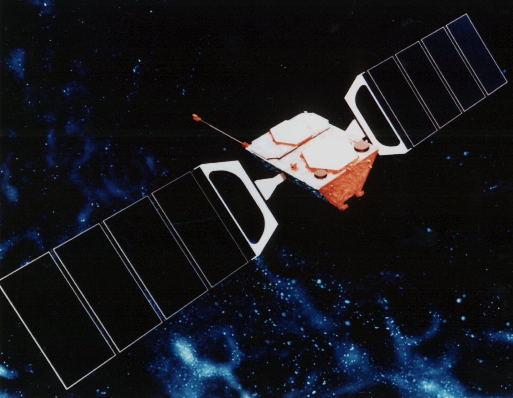
A geostationary satellite that had its “brains fried” by a solar flare (love that description by our pal Ian O’Neill at Discovery Space) stopped communicating with ground controllers last month and remains out of control. While the Galaxy 15 communication satellite is still functional, its navigation and communications system are not. The instruments remain “on” but the satellite has drifted out of its assigned orbital slot and will soon be coming close to other satellites. While it likely won’t crash into other satellites, the rogue satellite can cause problems when it enters an orbital space occupied by other satellites by “stealing” their signal, thereby interrupting other vendor’s services to customers on Earth.

Space News reports that a satellite operating at full payload power that is no longer under control is unprecedented, and the company that operates the satellite, Intelsat, is seeking advice from other satellite operators and manufacturers.

Galaxy 15 satellite before launch in 2005. Credi: Orbital Sciences.

On May 3, Intelsat tried unsuccessfully to shut down the electronics payload so that it wouldn’t interfere with any other satellites. Earlier, Intelsat tried a fruitless effort of sending between 150,000 and 200,000 commands to the satellite to coax it back into service, and then on Monday tried to force the satellite to shut down its transponders, and ultimately the satellite’s payload.

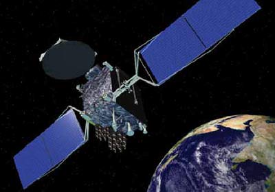
Galaxy 15, which normally operates at 133 degrees west longitude 36,000 kilometers over the equator, is now closing in on the geostationary orbital slot just two degrees away occupied by another satellite using the same bandwidth (C-band) the AMC-11 spacecraft operated by SES World Skies. With its active payload, Galaxy 15 could cause potentially severe interference with the SES satellite during a two-week period starting around May 23, according to Space News.

Galaxy 15 relays Global Positioning System (GPS) navigation information to in-flight aircraft.

The various satellite companies are working together to figure out how to deal with the problem. Check out Space News for more information.

GOES-P Goes to Space

GOES-P launches from Kennedy Space Center. Image Credit: Alan Walters (awaltersphoto.com) for Universe Today.

[/caption]
A Delta IV rocket rumbled and roared off launch pad 37B at Cape Canaveral Air Force Station in Florida Thursday evening, sending the GOES-P satellite soaring into a crisp and clear night sky. With liftoff at 6:57 p.m. EST, the rocket could be seen for several minutes after launch, and booster separation was clearly visible to observers on the NASA Causeway. The Geostationary Operational Environmental Satellite-P, or GOES-P, is the latest in a series of meteorological satellites designed to watch for storm development and weather conditions on Earth as well as detect hazards with its emergency beacon support and Search and Rescue Transponder. It will take ten days for the satellite to maneuver to its geostationary equatorial orbit at 35,888 km (22,300 miles). Once there, GOES-P will get a new name: GOES-15.

It will take five months for all the instruments on board to be tested and calibrated. After that, GOES-15 will be a back-up satellite, stored on-orbit and ready for activation should one of the operational GOES satellites degrade or exhaust their fuel.

The satellite is a cooperative effort between NASA and NOAA, the National Oceanic and Atmospheric Administration.

GOES-P launch. Image Credit: Alan Walters (awaltersphoto.com) for Universe Today.

NOAA has two operational GOES satellites: GOES-12 in the east and GOES-11 in the west. Each provides continuous observations of environmental conditions in North, Central and South America and the surrounding oceans. GOES-13 is being moved to replace GOES-12, which will be positioned to provide coverage for South America as part of the Global Earth Observing System of Systems, or GEOSS.

Thanks to Alan Walters for great images of the launch.

On a personal note, I’ve now seen three different launches – each with a different launch vehicle — in just four weeks here at Kennedy Space Center (space shuttle Endeavour, SDO on Atlas and now GOES-P on the Delta IV.) KSC is a busy spaceport, indeed!

With a Name Like GOES-P, This Satellite Has to be Good

The final spacecraft in this series of NASA and NOAA’s “GOES” geostationary environmental weather satellites is ready for launch. GOES stands for Geostationary Operational Environmental Satellite, and in evidence that not all acronyms turn out for the best, this latest satellite in the series is GOES-P. But (to quote the Bad Astronomer) this satellite will be a whiz in helping to provide continuous observations of severe weather events on Earth and space weather, too, as well as providing an update to search and rescue capabilities. Once in orbit GOES-P’s name will change to GOES-15. “GOES are the backbone of NOAA’s severe weather forecasts, monitoring fast-changing conditions in the atmosphere that spawn hurricanes, tornadoes, floods and other hazards,” said Steve Kirkner, GOES program manager at NASA’s Goddard Space Flight Center.

Launch is targeted for March 2, during a launch window from 6:19 to 7:19 p.m. EST from Space Launch Complex 37 at the Cape Canaveral Air Force Station on a Delta IV rocket. Universe Today will be on location to provide coverage of all the launch and pre-launch activities. Follow Nancy on Twitter for live updates.

“The latest series of satellites, GOES- N, O, and P has new capabilities in space weather,” said Dr. Howard Singer from NOAA. “This is data that arrives almost instantaneously and therefore allows us to provide very timely alerts and warnings.”

But GOES-P will be a back-up satellite. Once launched, it will be checked out and then stored on-orbit and ready for activation should one of the operational GOES satellites degrade or exhaust their fuel. Currently, NOAA operates GOES-12, (GOES East) and GOES-11 (GOES-West.) In late April, NOAA will activate GOES-13 to replace GOES-12, and move GOES-12 to provide coverage for South America as part of the Global Earth Observing System of Systems (GEOSS). NASA handed over GOES-14, launched last June, to NOAA on December 14, 2009.

In addition to weather forecasting on Earth, a key instrument onboard GOES-P, the Solar X-Ray Imager (SXI), will help NOAA continue monitoring solar conditions.

“The SXI is improving our forecasts and warnings for solar disturbances, protecting billions of dollars worth of commercial and government assets in space and on the ground, and lessening the brunt of power surges for the satellite-based electronics and communications industry,” said Tom Bodgan, director of NOAA’s Space Weather Prediction Center (SWPC) in Boulder, Colo.

GOES P is the last in the series. The first GOES satellite was launched in 1975.

GOES-P joins a system of weather satellites that provide timely environmental information to meteorologists and the public. The GOES system provides data used to graphically display the intensity, path and size of storms. Early warning of impending severe weather enhances the public’s ability to take shelter and protect property.

You can find launch status and a countdown here.

Source: NASA

Satellite View of “Snowmageddon”

The big snowfall of February 2010 as seen from space. Credit: MODIS Rapid Response Team at NASA GSFC.

[/caption]

Did you live through what has been called “snowmageddon” or “snowpocalypse?” Here’s a satellite’s-eye view of the exceptionally severe winter storm in the Eastern US that dropped several feet of snow on Feb. 6 and 7. Reports of crashed and abandoned cars and hundreds of cancelled flights were interspersed with stories of massive snowball fights. The huge snowfall may hinder highway traffic into midweek, and hundreds of thousands lost electricity. The image comes from the Moderate Resolution Imaging Spectroradiometer (MODIS) on NASA’s Terra satellite. Snow blankets the area hundreds of kilometers inland from the Atlantic coastline.

Source: NASA Earth Observatory

Satellite Captures Solar Eclipse from Space

Solar eclipse seen by Proba-2's SWAP instrument. Credit: ESA

[/caption]
The recently launched Proba-2 satellite was able to observe the annular solar eclipse on January 15, 2010, with stunning results. The PRoject for OnBoard Autonomy satellite was launched on November 2, 2009 and is intended to test hardware and software that might be incorporated into future ESA missions. The eclipse offered a unique chance to test out the Sun-imaging instrument, SWAP (Sun Watcher using APS detectors and imaging processing). Another radiometer instrument was also able to take measurements during the eclipse.

Proba-2 is one of the smallest satellites launched. The 0.6m by 0.6m by 0.8m satellite contains several instruments, a computer, battery, thrusters, and solar panel systems.

The eclipse was also detected by the Proba-2's LYRA (Lyman Alpha Radiometer) instrument. Credit: ESA

The eclipse was also detected by the Proba-2’s LYRA (Lyman Alpha Radiometer) instrument, the first ultraviolet radiometer in space that employs diamond detectors. LYRA will measure solar flares with an unprecedented rapid time resolution of 0.5 sec. LYRA data will soon be feeding research investigations and space weather forecasts.

Proba-2 was a secondary payload included on the launch of the SMOS mission, the Soil Moisture and Ocean Salinity Earth Explorer.

Source: ESA

Satellites Save the Day (and Lives)

COSPAS-SARSAT satellite system. Credit: NOAA

[/caption]
We all know how satellites make our lives better and easier (television, communications, GPS, weather forecasting, etc) but satellites also directly save people’s lives. In 2009 alone, satellites helped with the rescue of 195 people during life-threatening situations throughout the United States and its surrounding waters. In each incident, a NOAA satellites pinpointed downed pilots, shipwrecked mariners, or stranded hikers by detecting a distress signal from an emergency beacon and relaying the information to first responders on the ground.

NOAA’s polar-orbiting and geostationary satellites, along with Russia’s Cospas spacecraft, are part of the international Search and Rescue Satellite Aided Tracking system, called COSPAS-SARSAT. This system uses a network of satellites to quickly detect and locate distress signals from emergency beacons onboard aircraft and boats, and from smaller, handheld personal locator beacons.

“NOAA satellite weather and ocean data help us detect changes in weather and climate which is critically important to our everyday lives and economy,” said Mary E. Kizca, assistant administrator for NOAA’s Satellite and Information Service. “It’s a little known fact that these valuable instruments also made the difference between life and death for 195 people last year.”

When a NOAA satellite finds the location of a distress signal within the United States or its surrounding waters, the information is relayed to the SARSAT Mission Control Center based at NOAA’s Satellite Operations Facility in Suitland, Md. From there, it is sent to a Rescue Coordination Center, operated by either the U.S. Air Force, for land rescues, or the U.S. Coast Guard, for water rescues.

Now in its 28th year, COSPAS-SARSAT has been credited with supporting more than 27,000 rescues worldwide, including 6,232 in the United States and its surrounding waters. “With each rescue, the system performs the way it was intended – as a real life-saving network,” said Chris O’Connors, program manager for NOAA SARSAT.

Source: SatNews.com

UK’s Big Snowfall, As Seen From Space

Great Britain, as seen on Jan. 7, 2010 by the Terra Satellies. Credit: NASA

[/caption]
This satellite image taken by NASA’s Terra satellite shows the entire island of Great Britain blanketed by heavy snowfall, with some areas seeing the most snow in 50 years. It looks pretty from space, but frigid temperatures followed snowfall, leaving roads and sidewalks treacherously icy, according to news reports. As of January 7, overnight temperatures had plunged to -18 degrees Celsius (-0.4 degrees Fahrenheit) in isolated spots, with more widespread temperatures of -10 degrees Celsius (14 degrees Fahrenheit). The heavy snowfall downed power lines, leaving several thousand homes in southern England without electricity.

North America is also experiencing heavy snows and cold temperatures. NASA’s Earth Observatory website says that a possible contributor to the persistent cold and snow across much of the Northern Hemisphere’s mid-latitudes in December 2009 and January 2010 could be the fact that the atmosphere was in an extreme negative phase of the Arctic Oscillation (AO). The AO is a seesawing strengthening and weakening of semi-permanent areas of low and high atmospheric pressure in the Arctic and the mid-latitudes. One consequence of the oscillation’s negative phase is cold, snowy weather in Eurasia and North America during the winter months. The extreme negative dip of the Arctic Oscillation Index in December 2009 was the lowest monthly value observed for the past six decades.

Source: Earth Observatory

Artificial Satellites

It's getting crowded out there: active and inactive satellites are tracked (Google/Analytical Graphics)

[/caption]
Artificial satellites are human-built objects orbiting the Earth and other planets in the Solar System. This is different from the natural satellites, or moons, that orbit planets, dwarf planets and even asteroids. Artificial satellites are used to study the Earth, other planets, to help us communicate, and even to observe the distant Universe. Satellites can even have people in them, like the International Space Station and the Space Shuttle.

The first artificial satellite was the Soviet Sputnik 1 mission, launched in 1957. Since then, dozens of countries have launched satellites, with more than 3,000 currently operating spacecraft going around the Earth. There are estimated to be more than 8,000 pieces of space junk; dead satellites or pieces of debris going around the Earth as well.

Satellites are launched into different orbits depending on their mission. One of the most common ones is geosynchronous orbit. This is where a satellite takes 24 hours to orbit the Earth; the same amount of time it takes the Earth to rotate once on its axis. This keeps the satellite in the same spot over the Earth, allowing for communications and television broadcasts.

Another orbit is low-Earth orbit, where a satellite might only be a few hundred kilometers above the planet. This puts the satellite outside the Earth’s atmosphere, but still close enough that it can image the planet’s surface from space or facilitate communications. This is the altitude that the space shuttle flies at, as well as the Hubble Space Telescope.

Artificial satellites can have a range of missions, including scientific research, weather observation, military support, navigation, Earth imaging, and communications. Some satellites fulfill a single purpose, while others are designed to perform several functions at the same time. Equipment on a satellite is hardened to survive in the radiation and vacuum of space.

Satellites are built by various aerospace companies, like Boeing or Lockheed, and then delivered to a launch facility, such as Cape Canaveral. Launch facilities are located as close as possible to the Earth’s equator, to give an extra velocity kick into space. This allows rockets to use less fuel or launch heavier payloads.

The altitude of a satellite’s orbit defines how long it will stay in orbit. Low orbiting satellites are mostly above the Earth’s atmosphere, but they’re still buffeted by the atmosphere and their orbit eventually decays and they crash back into the atmosphere. Other satellites orbiting in high orbits will likely be there for millions of years.

We’ve written many articles about artificial satellites for Universe Today. Here’s an article about geosynchronous orbit, and here’s an article about orbital speed.

You can get more information about satellites from NASA. Here’s a cool realtime satellite tracking system, and here’s Hubblesite.

We’ve also recorded several episodes of Astronomy Cast about satellites. Here’s a good one, Episode 82: Space Junk.

Source: NASA

Google Satellite

If you’ve spent any time on the internet, you’ve probably had a chance to use either Google Earth or Google Maps. Both of these tools allow you to see a satellite view of the Earth, and zoom right in to see your home from space. But is there a Google satellite to take these photographs?

Google doesn’t actually have a satellite of their own. Instead, they use images from a variety of sources and store them on their servers. These images come from NASA satellites, USGS aerial surveys, and satellite photos from commercial operators. Google has an exclusive contract with a company called GeoEye, which recently launched their GeoEye-1 satellite. This commercial satellite blasted off on September 6, 2008, and is capable of resolving images on the Earth down to a size of 0.41 meters.

So how can you use these images? The easiest tool to use is Google Maps. This is a web-based tool that lets you browse around satellite photos of the Earth. You can zoom in and out, and type in a specific address anywhere on Earth to go right there. It also has driving directions, and all kinds of features that you can turn on and off to give you more information – like local sightseeing highlights.

The other tool that Google has created is called Google Earth. Unlike Google Maps, you actually need to download Google Earth to your local computer; PC, Mac, Linux, and even on your iPhone. Once you have the application installed, you see a 3-D version of the Earth that you can spin around, zoom in and out. You can zero in to any spot on Earth and see the highest resolution images they have available. There’s also a big community of developers who have created additional views that you can install. This lets you see additional photographs, contour maps, etc.

We have written many articles about Google satellite views. Here’s an article about how Google’s satellite had a bird’s eye view of the Obama Inauguration, and here’s a tool for Google Earth that lets you track satellite debris.

We’ve also recorded several episodes of Astronomy Cast about satellites. Listen here, Episode 100: Rockets.

Satellite Finder

Globalstar satellite

[/caption]
There are some amazing resources on the Internet that will let you track and find satellites in the sky. Did you know that the International Space Station is the brightest manmade object in the sky? It’s easy to see if you know when and were to look. So, this article should give you some good satellite finder resources, so you can track down and bag sightings of satellites.

The first place to start is NASA’s tracking page for the International Space Station, space shuttle and Hubble Space Telescope. This tells you where the spacecraft currently are, and also give you a way to find out when the spacecraft are going to be flying over your part of the world. They have a quick list of common locations, but you can also enter your latitude and longitude, and the system will give you some sighting opportunities.

Next, check out the Real Time Satellite Tracking page. This shows you the current position of thousands of satellites, and lets you see what’s overhead right now. You can set up satellite finders to watch the position of certain satellites. It’s an amazing resource.

Another great tool is Heaven’s Above. It lets you put in your local address, and then get predictions for satellites that will be overhead in the next few days. You can see the current position of the International Space Station, and much more.

If you have an iPhone, here’s a cool app that lets you find out the current location of the International Space Station and the space shuttle (if it’s in orbit right now).

If you have a satellite dish, and you need a satellite finder to maximize the strength of the signal, here’s a link to a Satellite finding kit from Amazon.com. It lets you finely tune the direction of your satellite dish to get the best signal from the satellite.

We have written many articles about satellites for Universe Today. Here’s an article about how you can watch satellites gather data in real time, and here’s a service that lets you launch your own satellite for only $8000.

We have done many episodes of Astronomy Cast about satellites. Listen to Episode 84: Getting Around the Solar System.