A 3-D Look At Europe’s New Galileo Satellite Navigation System

The European Union and European Space Agency (ESA) will launch the first components next week of the €20 billion Galileo global navigation satellite system. This constellation of satellites will allow users to pinpoint their location anywhere on Earth. It will be a free, fully autonomous and interoperable worldwide satellite navigation system, broadcasting global navigation signals for high-performance services, which ESA says possesses the service integrity guarantees that GPS lacks for commercial and safety-critical services.

The first launch is scheduled for October 20, 2011. This 3-D video provides an overview of the system. Use red/blue 3D glasses to watch in 3D.

German ROSAT Satelite Heading Towards Uncontrolled Re-Entry to Earth

A sample of 3 consecutive ROSAT orbits. Credit: DLR

[/caption]

Here we go again: A satellite without a propulsion system is set to crash to Earth later this month, and officials can’t predict exactly when or where it will fall. This is not the second coming of NASA’s UARS (Upper Atmosphere Research Satellite) but a German X-Ray observatory named ROSAT (ROentgen SATellite), which will likely plummet through Earth’s atmosphere sometime between October 20 and 25, plus or minus 3 days.

Due to fluctuations in solar activity, “the time and location of re-entry cannot be predicted precisely,” the German Aerospace Center (DLR) said in a statement on their website.

Coming in at about 28,000 kilometers (17,000 miles) per hour, DLR said the satellite will break up into fragments, with possibly up to 30 individual pieces weighing a total of 1.7 tons reaching the surface of the Earth. The largest single fragment will probably be the telescope’s mirror, which is very heat resistant and weighs about 1.7 tons.

German officials said there is a 1-in-2,000 chance that debris from the satellite could hit a person on Earth, and added the chance any a German citizen would be hit about 1 in 700,000. They did not include the odds of any one specific person on Earth getting hit by debris, but for the UARS satellite, it was estimated at about 1 in 21 trillion.

Like the UARS satellite, ROSAT’s orbital track takes it over much of Earth’s oceans.

An artist's impression of ROSAT in orbit. Credit: DLR

ROSAT is about the size of a car, and during its mission was in an elliptical orbit at distances of between 585 and 565 kilometers above the surface of the Earth. It was decommissioned in 1999, and since that time, atmospheric drag has caused the satellite to lose altitude. In June 2011, it was at a distance of only about 327 kilometers above the ground.

Since ROSAT does not have a propulsion system on board, it is not possible to maneuver the satellite to perform a controlled re-entry. ROSAT’s orbit extends to 53 degrees north and south latitudes, and all areas in that region could be affected by its re-entry. The bulk of the debris will impact near the ground track of the satellite. However, isolated fragments could fall to Earth in an 80-kilometer wide path along the track.

DLR will provide updates to predict the moment of re-entry as accurately as possible. During the re-entry phase of the satellite, German scientists will be evaluating data from the US Space Surveillance Network (SSN). In addition, the Tracking and Imaging Radar (TIRA), the large radar facility at the Fraunhofer Institute for High-Frequency Physics and Radar Techniques in Wachtberg near Bonn will be monitoring the descent of the X-ray satellite to further improve calculations of its trajectory.

Last month, the bus-sized 6-ton UARS satellite that hurtled uncontrolled toward Earth and plunged into the Pacific Ocean without causing any problems.

Source: DLR

UARS Update: Satellite Fell in Pacific Ocean

UARS satellite at 22:56 on Sept. 22, 2011, as seen from Puerto Rico. Credit: Effrain Morales Rivera.

[/caption]
NASA has confirmed that it’s decommissioned Upper Atmosphere Research Satellite fell back to Earth on Sept. 24 between 03:23 GMT and 05:05 GMT (11:23 p.m. EDT Friday, Sept. 23 and 1:09 a.m. EDT Sept. 24.) The Joint Space Operations Center at Vandenberg Air Force Base in California said the satellite entered the atmosphere over the North Pacific Ocean, off the west coast of the United States. The precise re-entry time and location of any debris impacts are still being determined. NASA is not aware of any reports of injury or property damage.

NASA will provide more information during a media telecon at 18:00 GMT (2 p.m. ET) to discuss the re-entry.

Artist concept of the UARS Satellite in orbit. Credit: NASA

Where will the UARS Satellite Crash?

ATV re-entry. Credit: ESA

[/caption]

The bus sized UARS (Upper Atmosphere Research Satellite) is expected to re-enter Earth’s atmosphere early morning GMT on September 24. Right now, the Center for Orbital and Reentry Debris Studies lists the projected re-entry time as 05:10 UT on Sept. 24, plus or minus 2 hours.

NASA UPDATE “As of 7 p.m. EDT on Sept. 23, 2011, the orbit of UARS was 90 miles by 95 miles (145 km by 150 km). Re-entry is expected between 11 p.m. Friday, Sept. 23, and 3 a.m., Sept. 24, Eastern Daylight Time (3 a.m. to 7 a.m. GMT). During that time period, the satellite will be passing over Canada, Africa and Australia, as well as vast areas of the Pacific, Atlantic and Indian oceans. The risk to public safety is very remote.”

Due to the robust nature of some of the parts on the satellite, it is likely that approximately 500kg of material will impact the ground or water.

The FAA (Federal Aviation Administration) has released a Local Air Safety Information special notice advising of the possibility of space debris.

The calculated risk that you’ll be hit by the falling space debris has been put at 1 in 3,200, said Nick Johnson, chief scientist with NASA’s Orbital Debris Program. But the chance that any one person on Earth getting hit by debris has been estimated at about 1 in 21 trillion.

It is highly unlikely that any injury or damage will be caused by this falling debris and NASA says; “The risk to public safety or property is extremely small, and safety is NASA’s top priority. Since the beginning of the Space Age in the late-1950s, there have been no confirmed reports of an injury resulting from re-entering space objects. Nor is there a record of significant property damage resulting from a satellite re-entry.”

It is still unsure where exactly the UARS satellite will pass over and re-enter the Earth’s atmosphere, but it will be an incredibly bright fireball visible even in daylight. But if some debris ends up near you, don’t worry too much — it won’t be flaming hot. NASA says any pieces of UARS landing on Earth will not be very hot. The heating of objects passing through the atmosphere stops at about 32 km (20 miles) up, and cools after that.

Stay posted for more updates and if you are lucky enough to get an image of UARS burning up please let us know and post your images on our flickr group

UARS Update: NASA Refines Crashing Satellite’s Debris Region and Location

This video from Analytical Graphics, Inc. shows an updated animated analysis of the break-up of the the 6-ton, bus-sized UARS satellite. It likely will burn up at an altitude between 80-45 kilometers, with an estimated 26 pieces of debris re-entering the atmosphere for land fall or splash down. The debris zone is predicted to be about 500 miles long.

The latest update put out by NASA on the Upper Atmosphere Research Satellite (UARS) is that as of 1:30 p.m. EDT Sept. 21, 2011, (17:30 GMT) the orbit of UARS was 120 mi by 130 mi (190 km by 205 km). Re-entry is expected sometime during the afternoon of Sept. 23, Eastern Daylight Time. NASA says the satellite will not be passing over North America during that time period, but that it is still too early to predict the time and location of re-entry with any more certainty. They will be able to further refine more details in the next 24 to 48 hours.

AGI has created an app for Android phones where you can track the UARS orbit track. See this link for more info.

Sources: NASA, AGI

Look Out Below! Huge Satellite Coming in for Uncontrolled Re-Entry

Artist concept of the UARS satellite. Credit: NASA

[/caption]

There’s a defunct 6.5-ton satellite heading our way. Trouble is, NASA’s not sure exactly where and when it might come down. And they’re not sure how much of it might survive its fiery fall through Earth’s atmosphere, either.

“Numerically, it comes out to a chance of 1-in-3,200 that one person anywhere in the world might be struck by a piece of debris,” said Nick Johnson, chief scientist with NASA’s Orbital Debris Program, during a media teleconference on Friday. “Those are obviously very, very low odds that anybody’s going to be impacted by this debris.”

Johnson reminded everyone that “throughout the entire 54 years of the space age, there have been no reports of anybody in the world being injured or severely impacted by any re-entering debris.”

How do you like your odds?

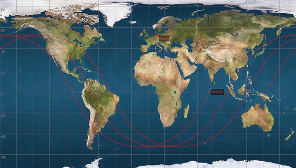
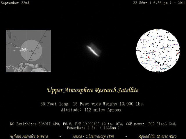
The huge 10-meter (35-ft) -long Upper Atmosphere Research Satellite (UARS) is in an orbit that crosses over six continents and three oceans. Johnson said it is expected to re-enter Earth’s atmosphere in an uncontrolled fall in late September or early October. While much of the spacecraft is expected to burn up during re-entry, it’s likely some pieces will make it to the ground. Current projections on where debris field might be is a 800-km- (500-mile) wide swath from Northern Canada to Southern South America.

Yikes.

Or it might fall in the ocean.

“We do know with 99.9 percent accuracy that it will re-enter the atmosphere somewhere between 57 degrees north and 57 degrees south, which means it will be anywhere from northern Canada to southern South America,” said Major Michael Duncan, deputy chief of space situational awareness with the Air Force’s U.S. Strategic Command. “That is truly the best estimation we can give you at this point in time.”

There are about 26 components that are big enough to survive and make it down to Earth, the largest weighing more than 150 kg (330 pounds.)

But hey, this happens all the time.

“Satellites re-entering is actually very commonplace,” Johnson said. “Last year, for example, we averaged over one object per day falling back uncontrolled into the atmosphere,” and for those coming back in an uncontrolled fashion – meaning it is a crapshoot when and where they fall — there were 75 metric tons of spacecraft and rocket bodies falling back to Earth.

“In perspective, UARS is less than six metric tons,” Johnson added. “So it’s a very small percentage of the annual re-entry of satellites.”

The majority of these satellites, though, were a lot smaller than UARS and they burn up completely in the atmosphere.

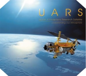
The UARS satellite launched from Space Shuttle Discovery in 1991. To give you an idea of how big the satellite is, it filled the shuttle’s payload bay completely. It had ten science instruments to examine the chemistry of the upper atmosphere and measure water vapor and other elements. It monitored the health of the ozone hole, looking at the amounts of aerosols in the atmosphere. In 2005 NASA determined that UARS was to be decommissioned.

It was never designed to be returned on the Space Shuttle, said Paul Hertz, chief scientist, NASA’s Science Mission Directorate.
Hertz said NASA is trying to keep the public informed about the the possibilities of debris failing and want to be up front about it. They will post all current information on www.nasa.gov/uars.

And Space Command will be tracking the satellite and providing updates as to where and when UARS will come down, and provide impact predictions if it looks like it will be coming down over land.

Although there are no hazardous materials on board – unlike the hydrazine on a National Reconnaissance Office spy satellite that was shot down in 2008 to avoid contaminating Earth – it was stressed that if anyone finds a piece of the satellite, they should not pick it up, but notify the local authorities.

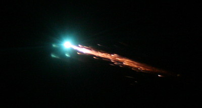
But anyone along the final trajectory should get “a nice show,” Johnson said.

“It is a relatively large vehicle,” he said. “It would be visible in daylight. Odds are, though, it’s going to happen over an ocean, unlikely to be seen unless it’s by an airliner. We’ve had reports like that before. Since we don’t know where it’s going to come in, we can’t raise people’s expectations and tell them to go out and look in their backyard. So it’ll be a serendipitous kind of event.”

Latest Satellite Images/Videos as Hurricane Irene Bears Down on US East Coast

GOES satellite image of Hurricane Irene as of 18:15 UTC on August 26, 2011. Credit: NOAA

What a view: Here’s a video of Hurricane Irene’s path, starting on August 24 up until 18:40 UTC on August 26, 2011, as seen by a GOES satellite. Even though Hurricane Irene is continuing to slowly weaken as it pushes closer to the Carolina coast, this massive storm could affect a huge area of the Eastern US seaboard, and tropical storm force winds and squalls are buffeting the coast. Irene will impact the entire Mid-Atlantic and Northeast Coast, including Washington, Philadelphia, New York City, Hartford, Ct. and Boston this weekend.

This hurricane spans nearly 1,000 kilometers (600 miles).

Below is a video taken from the International Space Station late yesterday afternoon. Includes astronaut commentary on the view of this “huge, scary storm” from 370 km (230 miles) up:

Or click on this link to see the latest video of Hurricane Irene from GOES and Goddard Space Flight Center

Cameras mounted on the International Space Station captured this video. Forecasters are predicting landfall on the outer banks of North Carolina Saturday before tracking up the mid-Atlantic states and a possible path over the metropolitan New York area and New England late this weekend.

[/caption]

Hot off the wires is this satellite image of Hurricane Irene taken less than an hour ago (as of this writing) by one of the GOES satellites for NOAA.

Here’s the latest from WeatherBug:

Imagery of Hurrican Irene from WeatherBug.com

And here’s the latest from the Moderate Resolution Imaging Spectroradiometer (MODIS) on the Terra satellite on August 25:

Hurricane Irene as seen by Moderate Resolution Imaging Spectroradiometer (MODIS) 
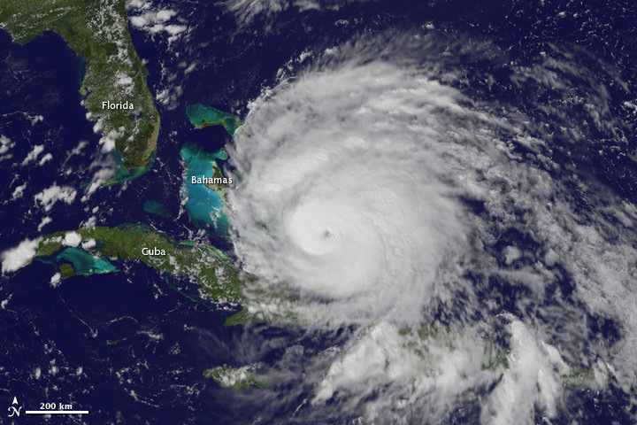
on the Terra satellite on August 25. Credit: NASA

See more up-to-date satellite images from NOAA’s cadre of Earth-observing satellites at this link.

Sources: NASA Earth Observatory, WeatherBug, NOAA, Goddard Space Flight Center

More Views of Hurricane Irene from Space: It’s Big

A view of Hurricane Irene taken by the GOES satellite at 2:55 p.m. Eastern Daylight Time on August 24, 2011. Credit: NASA

Here are several different views of Hurricane Irene: from 230 miles above the Earth, cameras on the International Space Station captured several views of powerful Hurricane Irene as it churned over the Bahamas at 3:10 p.m. EDT on August 24, 2011. Irene is moving to the northwest as a Category 3 hurricane, packing winds of 120 miles an hour. Irene is expected to strengthen to a Category 4 storm as it heads toward the Outer Banks of North Carolina, the Eastern Seaboard and the middle Atlantic and New England states.

See more from other satellites, below:

[/caption]

This view of Irene was taken by the GOES satellite at 2:55 p.m. Eastern Daylight Time on August 24, 2011. Irene now has a distinct eye and the clouds spiraling around the center are becoming more compact. The image also shows how large Irene has become, measuring several hundred kilometers across.

A three dimensional perspective of Irene, showing rainfall. Credit: NASA/TRMM satellite

This image was taken on August 22, but is a really nifty, three-dimensional view of the precipitation from Irene, as seen by the Tropical Rainfall Measuring Mission. It reveals an area of deep convection (shown in red) near the storm’s center where precipitation-sized particles are being carried aloft. These tall towers are associated with strong thunderstorms responsible for the area of intense rain near the center of Irene seen in the previous image. They can be a precursor to strengthening as they indicate areas within a storm where vast amounts of heat are being released. This heating, known as latent heating, is what is drives a storm’s circulation and intensification.

Here’s the latest view of Irene from WeatherBug:

View of Irene from WeatherBug.com

As of 8 a.m. EDT on August 25, Hurricane Irene was located near 25.5 N and 76.5 W, or 65 miles east-southeast of Nassau, Bahamas. This places it about 670 miles south of Cape Hatteras, N.C. Irene`s top sustained winds remain at 115 mph, and is moving to the northwest at 13 mph.

Sources: NASA Multimedia,

Explosive Phytoplankton Bloom Seen From Space

Phytoplankton bloom in the Barents Sea. Credit: NASA/Moderate Resolution Imaging Spectroradiometer (MODIS) on the Aqua satellite

[/caption]

Phytoplankton are tiny, microscopic plant-like organisms, but when they get together and start growing they can cover hundreds of square kilometers and be easily visible in satellite images. This image of the Barents Sea was taken on August 14, 2011 by the Moderate Resolution Imaging Spectroradiometer (MODIS) on the Aqua satellite. When conditions are right, phytoplankton populations can grow explosively, a phenomenon known as a bloom. A bloom may last several weeks, but the life span of any individual phytoplankton is rarely more than a few days. The area in this image is immediately north of the Scandinavian peninsula. Blooms spanning hundreds or even thousands of kilometers occur across the North Atlantic and Arctic Oceans every year. But, said Jeff Schmaltz from NASA’s Earth Observatory website, seeing such a wide area without clouds during the bloom is a rare treat.

Phytoplankton thrive in cold ocean waters, which tend to be rich in nutrients. Schmaltz said the milky blue color is an indicator that the bloom probably contains coccolithophores, which are plated with white calcium carbonate. Seen through ocean water, a coccolithophore bloom is bright blue. Other shades may be from other species of phytoplankton.

Source: NASA’s Earth Observatory website

Satellite Looks Down the Eye of Erupting Nabro Volcano

This false color satellite image shows active lava flows of the Nabro volcano in Eritrea on June 24, 2011. Credit: the Advanced Land Imager (ALI) aboard the Earth Observing-1 (EO-1) satellite.

[/caption]

Wow! What an amazing and detailed top-down view of an active volcano! This is the Nabro Volcano, which has been erupting since June 12, 2011. It sits in an isolated region on the border between Eritrea and Ethiopia and satellite remote sensing is currently the only reliable way to monitor the ongoing eruption, according to the NASA Earth Observatory website. The bright red portions of the false-color image (above) indicate hot surfaces. See below for a zoomed-in look. Both images were taken by the Advanced Land Imager (ALI) aboard the Earth Observing-1 (EO-1) satellite.


This natural-color image shows a close-up view of the volcanic plume and eruption site of the Nabro volcano. Credit: the Advanced Land Imager (ALI) aboard the Earth Observing-1 (EO-1) satellite

Robert Simmon of the NASA Earth Observatory website describes the scenes:

Hot volcanic ash glows above the vent, located in the center of Nabro’s caldera. To the west of the vent, portions of an active lava flow (particularly the front of the flow) are also hot. The speckled pattern on upstream portions of the flow are likely due to the cool, hardened crust splitting and exposing fluid lava as the flow advances. The bulbous blue-white cloud near the vent is likely composed largely of escaping water vapor that condensed as the plume rose and cooled. The whispy, cyan clouds above the lava flow are evidence of degassing from the lava.

The natural-color image (lower) shows a close-up view of the volcanic plume and eruption site. A dark ash plume rises directly above the vent, and a short, inactive (cool) lava flow partially fills the crater to the north. A gas plume, rich in water and sulfur dioxide (which contributes a blue tint to the edges of the plume) obscures the upper reaches of the active lava flow. Black ash covers the landscape south and west of Nabro.

Limited reports from the region say that at least 3,500 people and up to 9,000 that have been affected by the eruption, with at least 7 deaths caused by the erupting volcano. The ash plume has also disrupted flights in the region.

For more information see NASA’s Earth Observatory website, and BigThink