Satellite image of tropical storm "Debby" over the Gulf
The eastern Gulf of Mexico is getting lashed by tropical storm Debby, which whipped up tornado-spawning winds and dumped inches of rain across much of Florida, Mississippi, Alabama and southern Georgia over the weekend. NASA’s Aqua satellite acquired this image on June 23, just after the depression strengthened to full tropical storm status.
Born over the warm, moist air of the Gulf off the coast of Mississippi on Saturday afternoon, Debby quickly strengthened to storm status with sustained winds currently reported at over 60 mph. Slow-moving at a 6 mph crawl to the northeast, Debby continues to drench the Gulf state coasts with inches of rain — up to 10 to 20 inches projected for some areas. Major flooding has already become a problem and reports of tornadoes have been coming in since Sunday afternoon.
Debby will likely become a hurricane at some point, although her future path is still not entirely known.
Launched on May 4, 2002, NASA’s Aqua satellite specializes in keeping track of the movement of water around the planet in all its various forms. Find out more about the Aqua mission here.
Image: NASA/GSFC/Jeff Schmaltz/MODIS Land Rapid Response Team
After almost 35 years traveling at over 35,000 mph, the venerable (and still operational!) Voyager 1 spacecraft is truly breaking through to the other side, crossing the outermost boundaries of our solar system into interstellar space — over 11 billion miles from home.
Data received from Voyager 1 — a trip that currently takes the information 16 hours and 38 minutes to make — reveal steadily increasing levels of cosmic radiation, indicating that the spacecraft is leaving the relatively protected bubble of the Sun’s influence and venturing into the wild and wooly space beyond.
“The laws of physics say that someday Voyager will become the first human-made object to enter interstellar space, but we still do not know exactly when that someday will be,” said Ed Stone, Voyager project scientist at the California Institute of Technology in Pasadena. “The latest data indicate that we are clearly in a new region where things are changing more quickly. It is very exciting. We are approaching the solar system’s frontier.”
The data making the 16-hour-38 minute, 11.1-billion-mile (17.8-billion-kilometer), journey from Voyager 1 to antennas of NASA’s Deep Space Network on Earth detail the number of charged particles measured by the two High Energy telescopes aboard the 34-year-old spacecraft. These energetic particles were generated when stars in our cosmic neighborhood went supernova.
“From January 2009 to January 2012, there had been a gradual increase of about 25 percent in the amount of galactic cosmic rays Voyager was encountering,” said Stone. “More recently, we have seen very rapid escalation in that part of the energy spectrum. Beginning on May 7, the cosmic ray hits have increased five percent in a week and nine percent in a month.”
This marked increase is one of a triad of data sets which need to make significant swings of the needle to indicate a new era in space exploration. The second important measure from the spacecraft’s two telescopes is the intensity of energetic particles generated inside the heliosphere, the bubble of charged particles the sun blows around itself. While there has been a slow decline in the measurements of these energetic particles, they have not dropped off precipitously, which could be expected when Voyager breaks through the solar boundary.
“When the Voyagers launched in 1977, the space age was all of 20 years old. Many of us on the team dreamed of reaching interstellar space, but we really had no way of knowing how long a journey it would be — or if these two vehicles that we invested so much time and energy in would operate long enough to reach it.”
Addition: Check out the accompanying video from Science@NASA below:
Top image: Artist’s concept showing NASA’s two Voyager spacecraft exploring a turbulent region of space known as the heliosheath, the outer shell of the bubble of charged particles around our sun. Credit: NASA/JPL-Caltech. Secondary image: Artist’s concept of NASA’s Voyager spacecraft. Credit: NASA/JPL-Caltech.
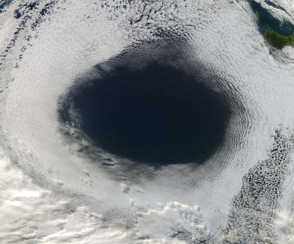
A vast hole in the cloud cover seen over the southern Pacific
[/caption]
Well, not the sky exactly, but definitely in the clouds!
This image, acquired by NASA’s Aqua satellite on June 5, shows an enormous oval hole in the clouds above the southern Pacific Ocean, approximately 500 miles (800 km) off the southwestern coast of Tasmania. The hole itself is several hundred miles across, and is the result of high pressure air in the upper atmosphere.
According to Rob Gutro of NASA’s Goddard Space Flight Center, “This is a good visible example of how upper-level atmospheric features affect the lower atmosphere, because the cloud hole is right under the center of a strong area of high pressure. High pressure forces air down to the surface blocking cloud formation. In addition, the altocumulus clouds are rotating counter-clockwise around the hole, which in the southern hemisphere indicates high pressure.”
The northwestern tip of Tasmania and King Island can be seen in the upper right of the image.
The Aqua mission is a part of the NASA-centered international Earth Observing System (EOS). Launched on May 4, 2002, Aqua has six Earth-observing instruments on board, collecting a variety of global data sets about the Earth’s water cycle. Read more about Aqua here.
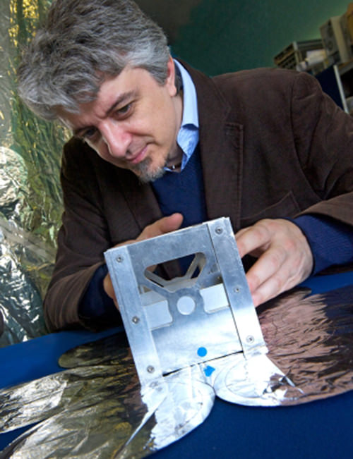
The University of Strathclyde's Dr. Massimiliano Vasile with a prototype of a SAM module
[/caption]
The dream of clean, consistent and renewable space solar power may become a reality, thanks to new research being done at The University of Strathclyde in Glasgow, Scotland.
The concept of space solar power — gathering solar energy with satellites in low-Earth orbit and “beaming” it down to collection stations on the ground — has been around for decades, but technology restrictions and prohibitive costs have kept it in the R&D phases, with some doubting that it will ever happen at all.
Now, researcher Dr. Massimiliano Vasile, of the University of Strathclyde’s Department of Mechanical and Aerospace Engineering, has announced his team’s development of modular devices that could be used to gather solar energy in orbit, working atop an experimental “space web” structure developed by graduate students at the university’s Department of Mechanical and Aerospace Engineering.
“By using either microwaves or lasers we would be able to beam the energy back down to earth, directly to specific areas. This would provide a reliable, quality source of energy and would remove the need for storing energy coming from renewable sources on ground as it would provide a constant delivery of solar energy.”
– Dr. Massimiliano Vasile, University of Strathclyde
The web structure, part of an experiment called Suaineadh — which means “twisting” in Scottish Gaelic (and I believe it’s pronounced soo-in-ade but correct me if I’m wrong) — is made of a central hub that would go into orbit and release a square web of material that’s weighted at the corners. The whole apparatus would spin, keeping its shape via centrifugal force and providing a firm structure that other devices could build upon and attach to.
The Suaineadh experiment was successfully launched on March 19 aboard a Swedish sounding rocket and while it appears that the components worked as expected, communication was lost after ejection. As a result the central hub — with all its data — couldn’t be located after landing. A recovery mission is planned for this summer.
Meanwhile, Dr. Vasile is still confident that his team’s space solar project, called SAM, can help provide space solar power to remote locations.
A single inflatable SAM cell (M. Vasile)
“The current project, called SAM (Self-inflating Adaptable Membrane) will test the deployment of an ultra light cellular structure that can change shape once deployed,” Dr. Vasile explains. “The structure is made of cells that are self-inflating in vacuum and can change their volume independently through nanopumps.
“The independent control of the cells would allow us to morph the structure into a solar concentrator to collect the sunlight and project it on solar arrays. The same structure can be used to build large space systems by assembling thousands of small individual units.”
By collecting solar energy in space, where the constraints of day and night or weather variability are nonexistent, the satellites could ultimately beam clean energy down to otherwise off-the-grid locales.
“In areas like the Sahara desert where quality solar power can be captured, it becomes very difficult to transport this energy to areas where it can be used,” says Dr. Vasile. “However, our research is focusing on how we can remove this obstacle and use space based solar power to target difficult to reach areas.
“By using either microwaves or lasers we would be able to beam the energy back down to earth, directly to specific areas. This would provide a reliable, quality source of energy and would remove the need for storing energy coming from renewable sources on ground as it would provide a constant delivery of solar energy.”
If successful, the Suaineadh/SAM project could develop into a source of renewable energy for not only small, remote locations but also neighborhoods, towns and perhaps even entire cities.
“Initially, smaller satellites will be able to generate enough energy for a small village but we have the aim, and indeed the technology available, to one day put a large enough structure in space that could gather energy that would be capable of powering a large city,” Dr. Vasile says.
Read more on the University of Strathclyde Glasgow’s site here.
Image credits: The University of Strathclyde. The project is part of a NASA Institute for Advanced Concepts (NIAC) study.
After ten years in orbit Envisat's mission has been declared over. (ESA)
[/caption]
Well, it’s official. After ten years of groundbreaking observation of our planet, ESA has declared the end of the Envisat mission after losing contact with the satellite on April 8, 2012. All attempts to re-establish communication with Envisat have so far been unsuccessful, and although recovery teams will continue to determine the cause of signal loss and try to regain a signal over the next several weeks, the mission — and the satellite — have been retired.
Having performed twice as long as originally planned, the hardworking Envisat has definitely earned its rest.
On April 8, the European Space Agency lost communication with the Earth-observation satellite, preventing reception of data as it passed over the Kiruna station in Sweden. Although later confirmed that the satellite is still in orbit, the recovery team has not been able to re-establish contact.
It’s thought that a loss of a power regulator could be blocking telemetry and telecommands from reaching Envisat, or else the satellite may have experienced a short-circuit and attempted to go into “safe mode” but experienced difficulties during the transition, leaving it in an unknown state.
ESA states that the chances of ever regaining communication with Envisat are extremely low.
While we had reported before on the last image received before falling silent, the image below is actually the final image from Envisat, an X-band image of the Canary Islands.
The final image from Envisat, acquired on April 8, 2012. (ESA/Edisoft)
During its lifetime, Envisat completed 50,000 orbits of Earth and returned over a thousand terabytes of data, containing invaluable measurements of our planet’s surface and atmosphere that were used in more than 2500 science publications.
The video below gives a fitting eulogy for a satellite that’s definitely overachieved and over-performed, giving us a decade of crucial observations of our world from orbit.
Full-disk image of Earth from Russia's Elektro-L satellite. (NTs OMZ)
[/caption]
Unlike most satellite images of Earth, this one was not assembled from multiple swath scans or digitally projected onto a globe model — it’s the full disk of our planet in captured as a single, enormous 121 megapixel image, acquired by Russia’s Elektro-L weather-forecasting satellite.
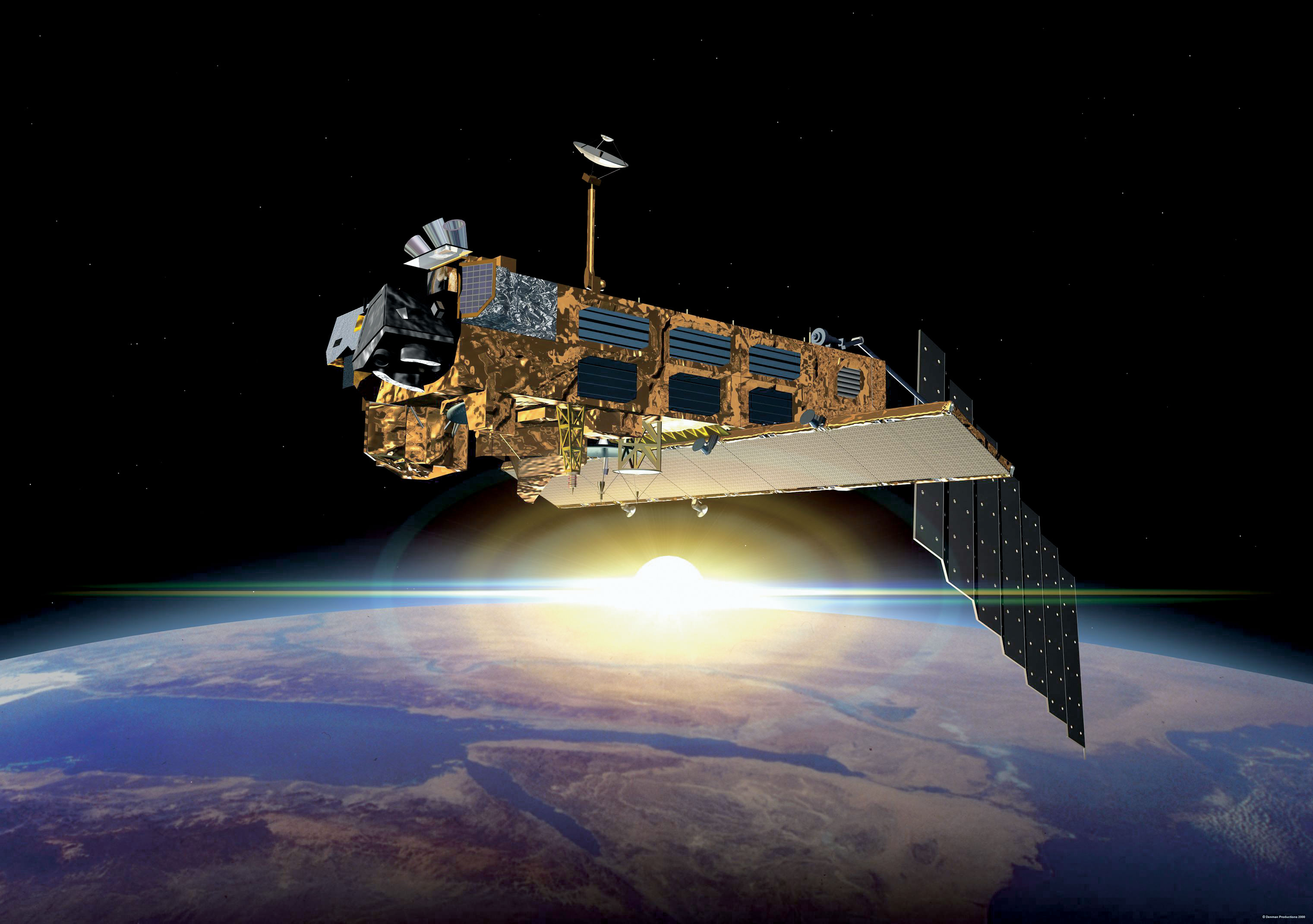
Like NASA’s GOES satellites, Elektro-L is parked in a geostationary orbit approximately 36,000 km (22,300 miles) above our planet. Unlike NASA’s satellites, however, Elektro-L captures images in near-infrared as well as visible wavelengths, providing detail about not only cloud movement but also vegetation variations. Its wide-angle Multichannel Scanning Unit (MSU) takes images every 15-30 minutes, showing the same viewpoint of Earth across progressive times of the day.
At a resolution of 0.62 miles per pixel, full-size Elektro-L images are some of the most detailed images of Earth acquired by a weather satellite.
Download the full-size image here (100+ megabytes).
Launched aboard a Zenit rocket on January 20, 2011, Elektro-L was the first major spacecraft to be developed in post-Soviet Russia. Parked over Earth at 76 degrees east longitude, Elektro-L provides local and global weather forecasting and analysis of ocean conditions, as well as “space weather” monitoring — measurements of solar radiation and how it interacts with Earth’s magnetic field. Its initial lifespan is projected to be ten years.
A second Elektro-L satellite is anticipated to launch in 2013.
Image credit: Russian Federal Space Agency / Research Center for Earth Operative Monitoring (NTS OMZ). See more images and video from Elektro-L on James Drake’s Planet Earth here. (Tip of the geostationary hat to Jesus Diaz at Gizmodo.)
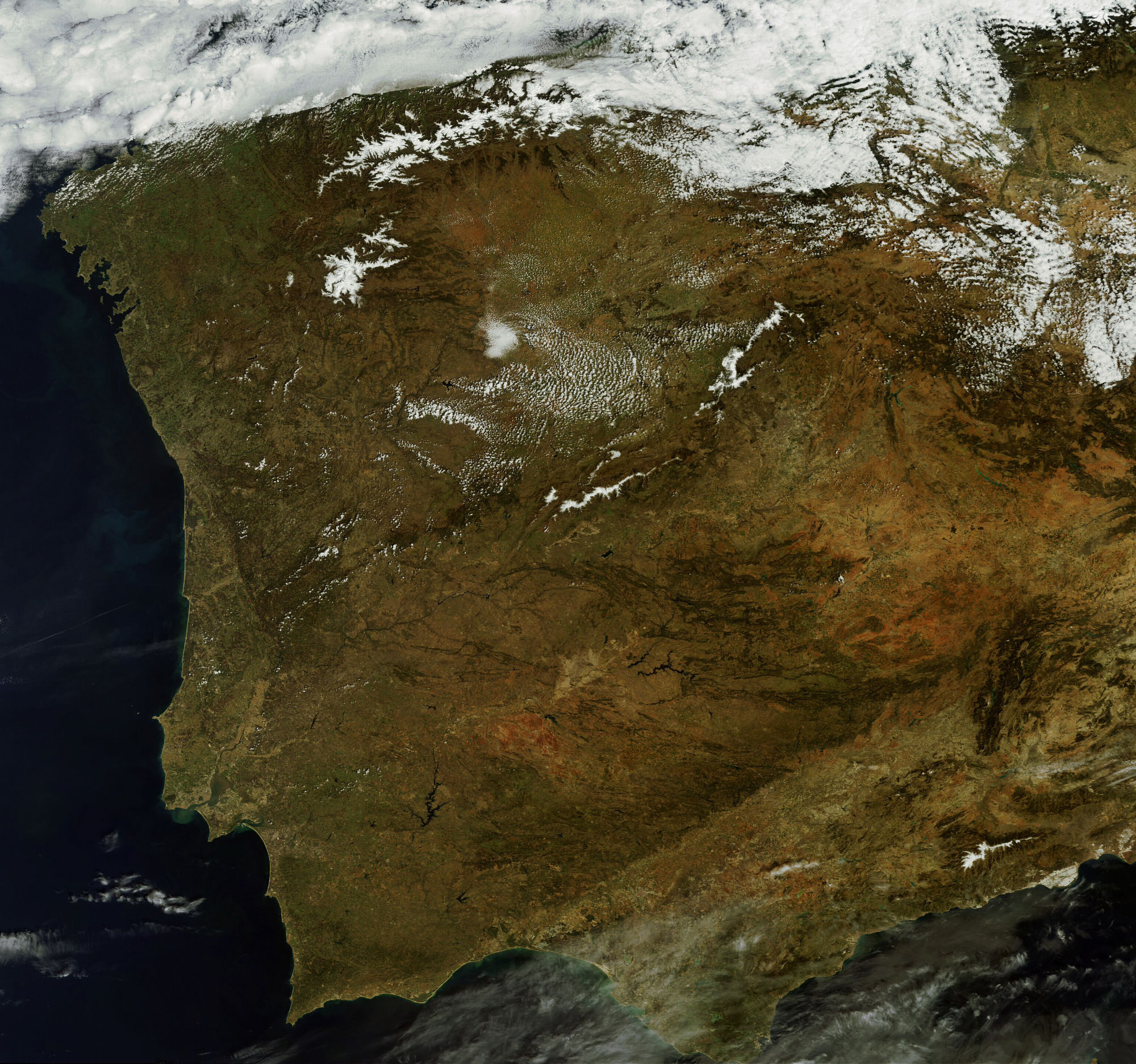
This MERIS image of Spain and Portugal could be Envisat's last. (Chelys/EOsnap)
[/caption]
The European Space Agency’s venerable Envisat satellite may have sent back its final image, according to recent news from the Agency.
On April 8, ESA lost communication with the Earth-observation satellite, preventing reception of data as it passed over the Kiruna station in Sweden. Although it’s been confirmed that the satellite is still in orbit, the recovery team has not been able to re-establish contact.
The image above, showing part of the Iberian peninsula, was from the last data to be received from Envisat before it fell silent.
Radar image of Envisat. (Fraunhofer Institute for High Frequency Physics and Radar Techniques.)
Launched in March 2002, Envisat has been helping researchers examine our planet for over ten years — five years longer than its original mission duration. It has completed more than 50,000 orbits and returned thousands of images, as well as a wealth of data about the land, oceans and atmosphere.
Envisat data was instrumental in over 4,000 projects from 70 countries.
Germany’s Tracking and Imaging Radar captured an image of the satellite, revealing that it is still intact and in a stable orbit. Still, all attempts at recovery have so far been unsuccessful.
A contingency agreement with the Canadian Space Agency on Radarsat will be activated to fulfill user requirements if Envisat cannot be brought back online.
Tendrils of ice particles, called frazil, extend out into Antarctica's Mackenzie Bay. (NASA/EO-1 - ALI)
[/caption]
Ghostly green tendrils drift out into Mackenzie Bay off the coast of eastern Antarctica in this image, acquired by NASA’s Earth-Observing (EO-1) satellite on Feb. 12, 2012.
The tendrils are made of fine particles of ice called frazil, the result of upwelling cold water from deep beneath the Amery ice shelf.
Sea water flowing in currents under the Amery ice shelf gets cooled to temperatures below freezing, the result of greater water pressures existing at depth. As some of the water rises and flows along the underside of the shelf toward the open ocean, it gradually encounters less pressure since the ice thickness decreases the further away from shore it extends.
When the supercold water approaches the surface where pressure is lowest, it instantly freezes, forming needle-like ice particles called frazil.
Only 3 -4 millimeters wide, the frazil crystals can still be concentrated enough to be visible from orbit as it drifts into the bay, flowing around icebergs as it is carried along by wind and currents. (The largest iceberg in the image is a little over 4 km/2.5 miles long.)
Eventually the warmer surface water that surrounds the southern continent melts the frazil, and the tendrils fade away.
Scheduled to fly for a year and only designed to last a year and a half, EO-1 celebrated its eleventh anniversary on November 21, 2011. During its time in orbit the satellite has accomplished far more than anyone dreamed, and its Earth-observing mission continues on. Read more on the EO-1 site here.
Clouds over the southern Indian Ocean, July 23, 2007. (NASA/JPL-Caltech)
[/caption]
Ok, maybe not the sky itself… but the clouds. According to recent research by climate scientists in New Zealand, global cloud heights have dropped.
Researchers at The University of Auckland have reported a decreasing trend in average global cloud heights from 2000 to 2010, based on data gathered by the Multi-angle Imaging SpectroRadiometer (MISR) on NASA’s Terra satellite. The change over the ten-year span was 30 to 40 meters (about 100 to 130 feet), and was mostly due to fewer clouds at higher altitudes.
It’s suspected that this may be indicative of some sort of atmospheric cooling mechanism in play that could help counteract global warming.
“This is the first time we have been able to accurately measure changes in global cloud height and, while the record is too short to be definitive, it provides just a hint that something quite important might be going on,” said lead researcher Professor Roger Davies.
A steady reduction in cloud heights could help the planet radiate heat into space, thus serving as a negative feedback in the global warming process. The exact cause of the drop in cloud altitude is not yet known, but it could reasonably be resulting from a change in circulation patterns that otherwise form high-altitude clouds.
Rendering of the Terra spacecraft. (NASA)
Cloud heights are just one of the many factors that affect climate, and until now have not been able to be measured globally over a long span of time.
“Clouds are one of the biggest uncertainties in our ability to predict future climate,” said Davies. “Cloud height is extremely difficult to model and therefore hasn’t been considered in models of future climate. For the first time we have been able to accurately measure the height of clouds on a global basis, and the challenge now will be to incorporate that information into climate models. It will provide a check on how well the models are doing, and may ultimately lead to better ones.”
While Terra data showed yearly variations in global cloud heights, the most extreme caused by El Niño and La Niña events in the Pacific, the overall trend for the years measured was a decrease.
Continuing research will be needed to determine future trends and how they may impact warming.
“If cloud heights come back up in the next ten years we would conclude that they are not slowing climate change,” Davies said. “But if they keep coming down it will be very significant.”
The team’s study was recently published in the journal Geophysical Research Letters.
Terra is a multi-national, multi-disciplinary mission involving partnerships with the aerospace agencies of Canada and Japan. An important part of NASA’s Science Mission, Terra is helping scientists around the world better understand and protect our home planet.
Satellite image of RI and portions of southeastern Massachusetts. Credit: NASA/GSFC/Landsat 7
[/caption]
If you live in or are from the US, you probably know that today is Super Bowl Sunday. Whatever you happen to be doing, be it tailgating in Indianapolis, getting together with friends and family (and plenty of hot wings and nachos) in your living room or just waiting for all the fuss to be over, remember that, high above, NASA Earth-observing satellites are working hard doing what they do best: observing the Earth. Chances are they’ve imaged your home town many times.
Whichever team you’re rooting for, here’s a little bit of space science fun: the folks over at Goddard Space Flight Center in Greenbelt, MD, have shared some Landsat images of the home cities of this year’s big game.
The image above shows the central and northern RI and southeastern Massachusetts area, with Providence and Pawtucket seen as the densely-built central region and Foxborough, MA, where the Patriots’ home stadium is located, is just to the north of the image. This image was acquired by Landsat 7 in July 2002.
(Being of my home state, I admit I’m partial to that particular shot. I was down there somewhere!)
The NYC area seen from satellite. Credit: NASA/GSFC/Landsat 7
If you’re a die-hard Giants fan, you may recognize this area… you may even be in it! It’s a Landsat 7 image of the New York metro area acquired on August 8, 2002. Manhattan is in the center, most easily recognizable from space by the green rectangle of Central Park. New Jersey is on the left side, and Brooklyn on the center-right with Long Island stretching away to the east.
Indianapolis from Landsat 7 satellite. Credit: NASA/GSFC/Landsat 7
If you’re lucky enough to have tickets to the big game, you may be here: it’s a Landsat image of Indianapolis, IN acquired on July 11, 2001. The Colts may not have made it this year but right now the city is definitely “ready for some football!”
Of course, team and town loyalty aside, this gorgeous image from Expedition 30 crew members aboard the ISS shows everyone all in one place on the night of January 29, 2012 – with a nice touch of northern lights thrown in for good measure:
US East Coast on Jan. 29, 2012. (NASA)
Bright lights, big cities… but a small world, when you think about it. And remember, whichever team comes out on top today, tomorrow we’re all winners. (Until next season, of course!)