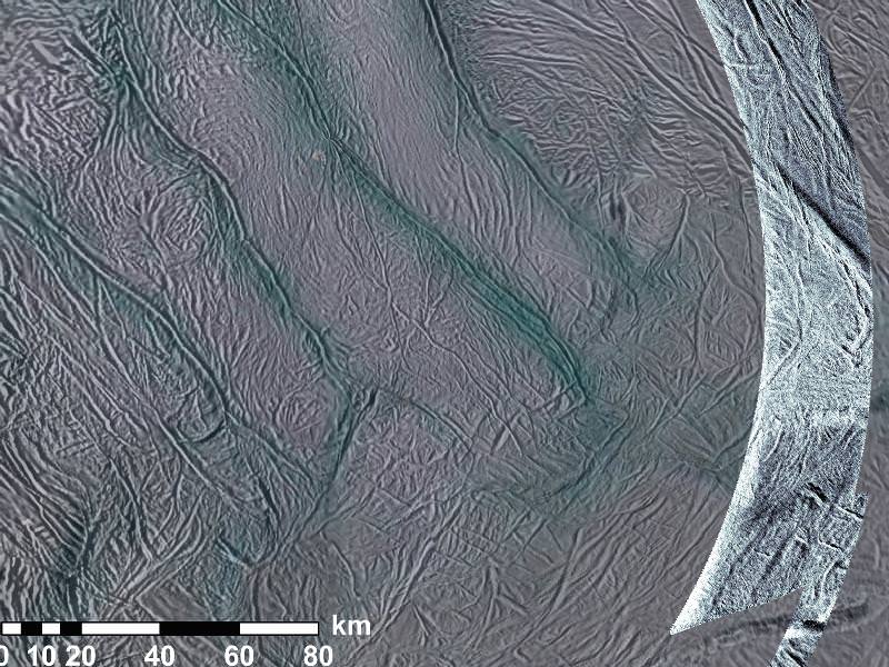
New radar images from Encealdus' south pole show high amounts of surface texturing. NASA/JPL-Caltech/SSI.
[/caption]
Cassini’s done it again! Soaring over Saturn’s moon Enceladus back on November 6, the spacecraft obtained the highest-resolution images yet of the moon’s south polar terrain, revealing surface details with visible, infrared and radar imaging that have never been seen before.
Of particular interest are new image swaths acquired by the spacecraft’s synthetic-aperture radar (SAR) instrument, which has never before been used on Enceladus. The radar, which is highly sensitive to surface textures, reveals some extremely bright regions that have surprised scientists.
Detail of the radar-imaged area (enlarged). NASA/JPL-Caltech/SSI.
“It’s puzzling why this is some of the brightest stuff Cassini has seen,” said Steve Wall, deputy team lead of Cassini’s radar team based at NASA’s Jet Propulsion Laboratory in Pasadena. “One possibility is that the area is studded with rounded ice rocks. But we can’t yet explain how that would happen.”
The SAR images did not focus on the moon’s now-famous “tiger stripe” fractures (called sulci) which are the sources of its icy jets. Instead, Cassini scanned areas a few hundred miles around the stripes. These regions have not been extensively imaged before and this new data shows surface patterns and elevations that had been previously unknown.
Some of the steep grooves in the imaged areas were shown to be as deep as 2,100 feet (650 m), and 1.2 miles (2 km) wide.
Cassini passed by the 318-mile (511-km) -wide moon at 04:49 UTC on November 6, 2011. Cassini’s radar instrument was built by JPL and the Italian Space Agency, working with team members from the U.S. and several European countries. Previously used to image the surface of Titan, which is hidden from view by a thick atmosphere, this is the first time the instrument was used on Enceladus.
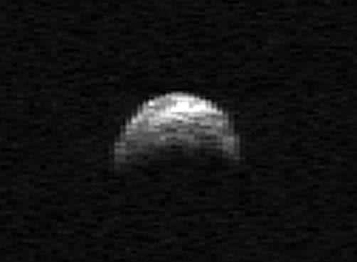
A radar image an asteroid, 2005 YU55, acquired in April 2010. (This is not the asteroid that will pass by Earth on Jan. 27, 2012)Credit: NASA
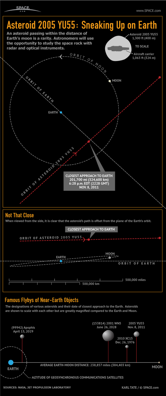
NASA’s Jet Propulsion Laboratory released this video today featuring more information about the much-discussed 2005 YU55, a 400-meter-wide asteroid that will pass by Earth next Tuesday at a distance closer than the Moon. The video features research scientist Lance Benner, an expert in radio imaging of near-Earth objects.
While YU55 will come closer than any object we’ve been aware of in the past 35 years, it poses no risk to Earth.
“2005 YU55 cannot hit Earth, at least over the interval that we can compute the motion reliably, which extends for several hundred years.”
– Lance Benner, JPL Research Scientist
[/caption]
While we can’t state enough that there’s no danger from YU55, this close pass will offer a fantastic opportunity for scientists to acquire detailed radar images of this ancient C-type asteroid.
NASA’s Near-Earth Objects Observation Program will continue tracking YU55 using the 70-meter radar telescope at the Deep Space Network in Goldstone, California, as well as with the Arecibo Planetary Radar Facility in Puerto Rico.
“This is the closest approach by an asteroid this large that we’ve known about in advance,” said Benner. “The Goldstone telescope has a new radar imaging capability which has just become available that will enable us to see much finer detail than has previously been possible.”
Radar imaging allows scientists to better study the surface features and composition of fast-moving, dark objects like YU55 which reflect very little visible light.
Space.com has provided a great infographic that shows exactly where this asteroid will pass by Earth. Note that the side view plainly shows that the path of the asteroid is well above the plane of the Earth/Moon orbit.
Radar is one of the those technologies that changed everything: it allows boats and aircraft to “see” at night and through thick fog. But it also changed astronomy and ground imaging, tracking asteroids with great accuracy, allowing spacecraft to peer through Venus’ thick clouds and revealing secrets beneath the Earth’s shifting sands.
A space radar picked up the sounds of a meteor shower as it delighted skywatchers over the weekend.
What do meteors sounds like as they hit Earth’s atmosphere? From this recording made by the U.S. Air Force Space Surveillance Radar in Texas, the “pings” from the Perseid Meteor Shower sound rather alien! The radar station in Lake Kickapoo, Texas is part of United States Strategic Command’s (USSTRATCOM), which involves detecting, tracking, cataloging and identifying artificial objects orbiting Earth, such as both active and inactive satellites, spent rocket bodies, or fragments of debris from natural and man-made objects. Reportedly, the radar can detect objects as small as 10 cm (four inches) at heights up to 30,000 km.
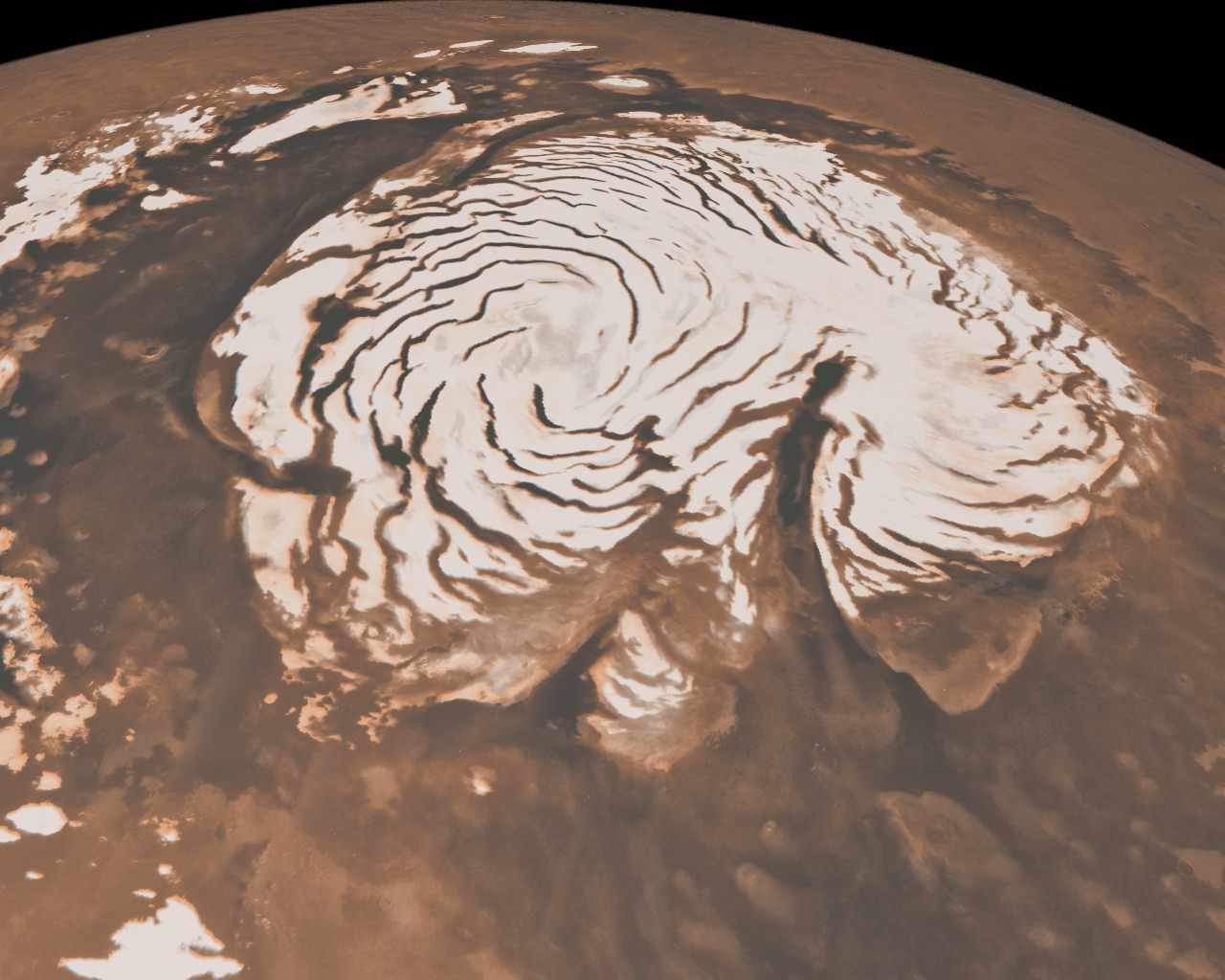
The spiral troughs and gian canyon Chasma Borale have puzzled scientists for 40 years.
[/caption]
The shape of the two-mile-tall Texas-sized ice cap at the north pole of Mars has puzzled scientists for forty years, but new results to be published in a pair of papers in the journal Nature on May 27 have put the controversy to rest.
The polar caps of Mars have been known since the first telescopic views of the planet, but early spacecraft images revealed that the north polar cap is scored by enigmatic troughs that spiral out from its center, as well as a chasm larger than the Grand Canyon. The origin of these features has been debated since they were first discovered in 1972.
One hypothesis to explain the giant canyon, called Chasma Boreale, is that volcanic heat melted the ice and caused a catastrophic flood that formed the chasm. Other scientists have suggested that wind sweeping downhill from the top of the cap carved Chasma Boreale from the ice.
Multiple explanations have been suggested for the spiral troughs too. One explains the troughs as fractures caused by the flow of ice from the pole. Another uses a model to suggest that the troughs are the natural result of solar heating and lateral heat conduction in the ice.
The two new papers, led by Jack Holt and Isaac Smith of The University of Texas at Austin’s Institute for Geophysics, used data from the Shallow Subsurface Radar (SHARAD) on the Mars Reconnaissance Orbiter (MRO) to study the internal structure of the ice cap and discover the origin of the troughs and the chasm.
“SHARAD sends pulses of radio waves from orbit, 700 times per second,” Holt explained. “Some energy is reflected from the surface, and then from subsurface interfaces if the intervening material allows the radio waves to penetrate. Radar at this wavelength (about 20 meters) penetrates ice very well, and it has been used from airplanes on Earth to map large portions of Earth’s ice sheets.”
“By putting all of the reflections together one can make an image of what lies beneath the
surface,” Smith added.
Holt explained that the ability to map not only the surface features but also the internal structure of the ice cap “opens the door to better understand what we see on the surface by providing critical context in time.”
Top: An example SHARAD radar cross section of the martian north polar cap. Bottom: An annotated version of the same cross-section.
By mapping the three-dimensional structure of the north polar ice cap, Smith and Holt have determined that both the troughs and Chasma Boreale were formed by katabatic winds, which blow down from the top of the ice cap.
“We aren’t saying they were carved by wind, rather that wind had a strong role in their formation and evolution.” Holt said. “Chasma Boreale is an old feature that persisted because new ice did not accumulate there, likely due to persistent winds coming from the highest point on the ice cap.”
Holt also discovered evidence for another old canyon that has been completely filled in over time. “No evidence remains on the surface to indicate that it was there previously,” Holt said. “We can map it in the radar data, however.”
The spiral troughs likewise are controlled by the wind. “The radar layers we see show evidence for wind transport because they vary in thickness and elevation [across the troughs],” Smith, lead author of the trough paper, explained. “The wind moves across the trough instead of through it [and] moves ice from the upwind side (thereby thinning they layer) to the downwind side (adding more to the existing layer).”
This causes the spiral troughs to migrate upwind over time, a phenomenon first proposed by Alan Howard, a researcher at the University of Virginia, in 1982. “Many people proposed other hypotheses suggesting he was wrong,” Smith said. “But when you look at a hypothetical cross section from his paper, it looks almost exactly like what we see in the radar data. We were amazed at how accurate Alan Howard predicted what we would
see.”
The troughs are spiral shaped due to the planet’s rotation. As the katabatic winds blow from the center of the cap down to lower latitudes they are twisted by the same “coriolis force” that causes hurricanes to spiral on the Earth.
The layers that Holt and Smith mapped using radar data also suggest that ice flows are much rarer on Mars than they are on Earth. The lack of flows means that the polar ice on Mars preserves more complex layers than expected. “This complexity provides very specific constraints on the climatic processes responsible for [the layers],” Holt said. “We will eventually be able to reconstruct winds and accumulation patterns across the polar cap and through time.”
Holt plans to use the ancient polar landscapes inferred from the SHARAD data along with simulations of the martian climate to model the formation of the polar cap. “If we can recreate the major features such as Chasma Boreale [in the models], then we will have learned a great deal about climate on Mars during that period.”
Smith and Holt also plan to study the effect of Mars’ tilt on the formation of the ice cap. “Because Mars’ orbit and tilt change so much with respect to the sun, it would be nice to see how that has affected deposition of ice on the cap. This requires much more mapping, and we have already begun that process,” Smith said.
“There is still much research to do on Mars,” Smith said. “The planet has a lot of mysteries, some of which we haven’t even found yet.”