NOAA/NASA/USAF Deep Space Climate Observatory (DSCOVR) Launching Feb. 8 to Monitor Solar Winds

DSCOVR mission logo. Credit: NOAA/NASA/U.S. Air Force

The long awaited Deep Space Climate Observatory, or DSCOVR science satellite is slated to blast off atop a SpaceX Falcon 9 on Sunday, Feb. 8, from Cape Canaveral, Florida on a mission to monitor the solar wind and aid very important forecasts of space weather at Earth.

DSCOVR is a joint mission between NOAA, NASA, and the U.S Air Force (USAF) that will be managed by NOAA. The satellite and science instruments are provided by NASA and NOAA.

Update Feb 8: Hold, Hold, Hold !!! 6:10 PM 2/8/15 Terminal Count aborted at T Minus 2 min 26 sec due to a tracking issue. NO launch of Falcon 9 today. rocket being safed now. next launch opportunity is Monday. Still TBD.

The rocket is provided by the USAF. SpaceX will try to recover the first stage via a guided descent to a floating barge in the Atlantic Ocean.

The weather outlook is currently very promising with a greater than 90 percent chance of favorable weather at launch time shortly after sunset on Sunday which could make for a spectacular viewing opportunity for spectators surrounding the Florida Space coast.

Liftoff atop the SpaceX Falcon 9 rocket is targeted for at 6:10:12 p.m. EST on Feb. 8, from Cape Canaveral Air Force Station Space Launch Complex 40.

There is an instantaneous launch window, meaning that any launch delay due to weather, technical or other factors will force a scrub to Monday.

The launch will be broadcast live on NASA TV: http://www.nasa.gov/nasatv

NASA’s DSCOVR launch blog coverage of countdown and liftoff will begin at 3:30 p.m. Sunday.
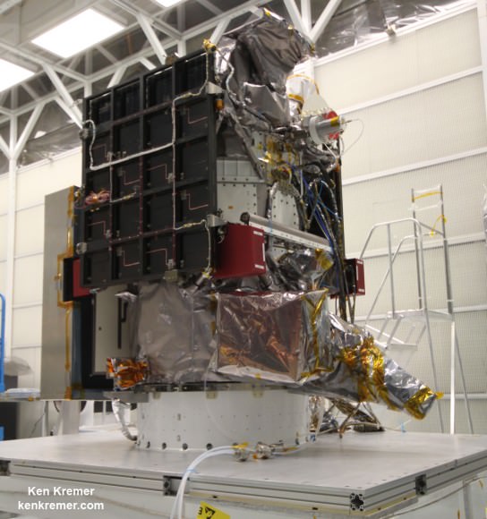
NOAA/NASA Deep Space Climate Observatory (DSCOVR) undergoes processing in NASA Goddard Space Flight Center clean room. Solar wind instruments at right. DSCOVER will launch in February 2015 atop SpaceX Falcon 9 rocket.  Credit: Ken Kremer/kenkremer.com/AmericaSpace
NOAA/NASA Deep Space Climate Observatory (DSCOVR) undergoes processing in NASA Goddard Space Flight Center clean room. Solar wind instruments at right. DSCOVER will launch in February 2015 atop SpaceX Falcon 9 rocket. Credit: Ken Kremer/kenkremer.com/AmericaSpace

“DSCOVR is NOAA’s first operational space weather mission to deep space,” said Stephen Volz, assistant administrator of the NOAA Satellite and Information Service in Silver Spring, Maryland, at the pre-launch briefing today (Feb. 7) at the Kennedy Space Center in Florida.

The mission of DSCOVR is vital because its solar wind observations are crucial to maintaining accurate space weather forecasts to protect US infrastructure from disruption by approaching solar storms.

“DSCOVR will maintain the nation’s solar wind observations, which are critical to the accuracy and lead time of NOAA’s space weather alerts, forecasts, and warnings,” according to a NASA description.

“Space weather events like geomagnetic storms caused by changes in solar wind can affect public infrastructure systems, including power grids, telecommunications systems, and aircraft avionics.”

DSCOVR will replace NASA’s aging Advanced Composition Explorer (ACE) satellite which is nearly 20 years old and far beyond its original design lifetime.

The couch sized probe is being targeted to the L1 Lagrange Point, a neutral gravity point that lies on the direct line between Earth and the sun located 1.5 million kilometers (932,000 miles) sunward from Earth. At L1 the gravity between the sun and Earth is perfectly balanced and the satellite will orbit about that spot just like a planet.

L1 is a perfect place for the science because it lies outside Earth’s magnetic environment. The probe will measure the constant stream of solar wind particles from the sun as they pass by.
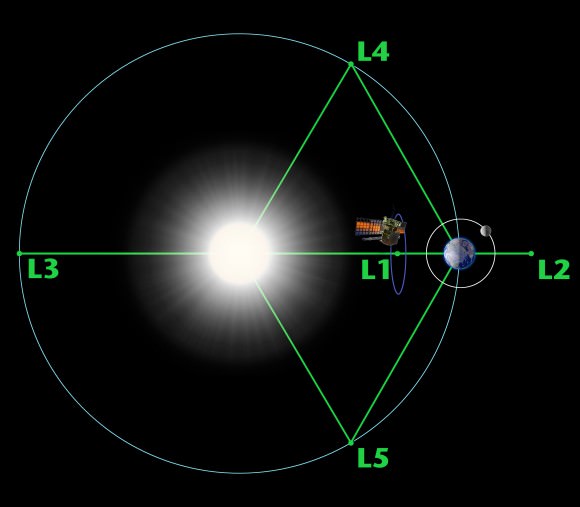
Diagram of the five Lagrange points associated with the sun-Earth system, showing DSCOVR orbiting the L-1 point. Image is not to scale.  Credit:  NASA/WMAP Science Team
Diagram of the five Lagrange points associated with the sun-Earth system, showing DSCOVR orbiting the L-1 point. Image is not to scale. Credit: NASA/WMAP Science Team

This will enable forecasters to give a 15 to 60 minute warning of approaching geomagnetic storms that could damage valuable infrastructure.

DSCOVR is equipped with a suite of four continuously operating solar science and Earth science instruments from NASA and NOAA.

It will make simultaneous scientific observations of the solar wind and the entire sunlit side of Earth.

Three instruments will help measure the solar wind on the DSCOVR mission: (shown from left to right), the Faraday cup to monitor the speed and direction of positively-charged solar wind particles, the electron spectrometer to monitor electrons, and a magnetometer to measure magnetic fields.  Credit: NASA/DSCOVR
Three instruments will help measure the solar wind on the DSCOVR mission: (shown from left to right), the Faraday cup to monitor the speed and direction of positively-charged solar wind particles, the electron spectrometer to monitor electrons, and a magnetometer to measure magnetic fields. Credit: NASA/DSCOVR

The 750-kilogram DSCOVR probe measures 54 inches by 72 inches.

I saw the DSCOVR spacecraft up close at NASA Goddard Space Flight Center in Maryland last fall during processing in the clean room.
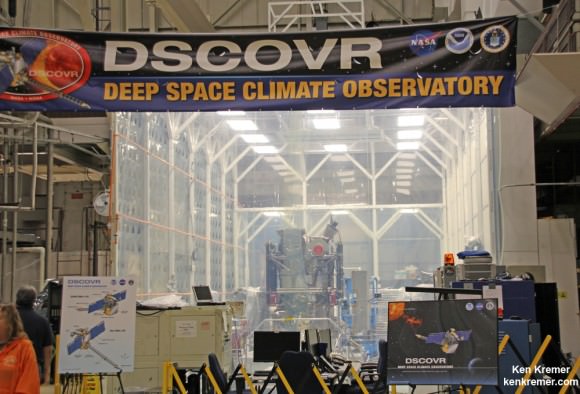
NOAA/NASA/USAF Deep Space Climate Observatory (DSCOVR) undergoes processing in NASA Goddard Space Flight Center clean room.  Probe will launch in February atop SpaceX Falcon 9 rocket.  Credit: Ken Kremer - kenkremer.com
NOAA/NASA/USAF Deep Space Climate Observatory (DSCOVR) undergoes processing in NASA Goddard Space Flight Center clean room. Probe will launch in February atop SpaceX Falcon 9 rocket. Credit: Ken Kremer – kenkremer.com

A secondary objective of the rocket launch for SpaceX is to conduct their second attempt to recover the Falcon 9 first stage booster on an ocean going barge. Read my articles about the first attempt in January 2015, starting here.

It was originally named ‘Triana’ (aka Goresat) and was conceived by then US Vice President Al Gore as a low cost satellite to take near continuous views of the Earth’s entire globe to feed to the internet as a means of motivating students to study math and science. It was eventually built as a much more capable Earth science satellite as well as to conduct the space weather observations.

But Triana was shelved for purely partisan political reasons and the satellite was placed into storage and the science was lost until now.

Stay tuned here for Ken’s continuing Earth and planetary science and human spaceflight news.
Ken Kremer

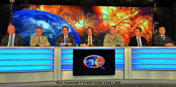
The team is ready for the launch of NASA's DSCOVR spacecraft aboard a SpaceX Falcon 9 rocket. L/R Mike Curie KSC NASA News Chief, Stephen Volz, assistant administrator NOAA, Tom Berger, director of NOAA Space Weather Prediction Center Boulder Colorado,Steven Clark, NASA Joint Agency Satellite Division, Col. D. Jason Cothern, Space Demonstration Division chief at Kirkland AFB NM. Hans Koenigsmann, VP of mission assurance at SpaceX in Hawthorne, California, Mike McAlaneen, launch weather officer 45th Space wing Cape Canaveral Air Force Station, Florida.  Credit: Julian Leek
The team is ready for the launch of NASA’s DSCOVR spacecraft aboard a SpaceX Falcon 9 rocket. L/R Mike Curie KSC NASA News Chief, Stephen Volz, assistant administrator NOAA, Tom Berger, director of NOAA Space Weather Prediction Center Boulder Colorado,Steven Clark, NASA Joint Agency Satellite Division, Col. D. Jason Cothern, Space Demonstration Division chief at Kirkland AFB NM. Hans Koenigsmann, VP of mission assurance at SpaceX in Hawthorne, California, Mike McAlaneen, launch weather officer 45th Space wing Cape Canaveral Air Force Station, Florida. Credit: Julian Leek

NASA and NOAA Satellites Image Crippling Blizzard of 2015 Pounding New England

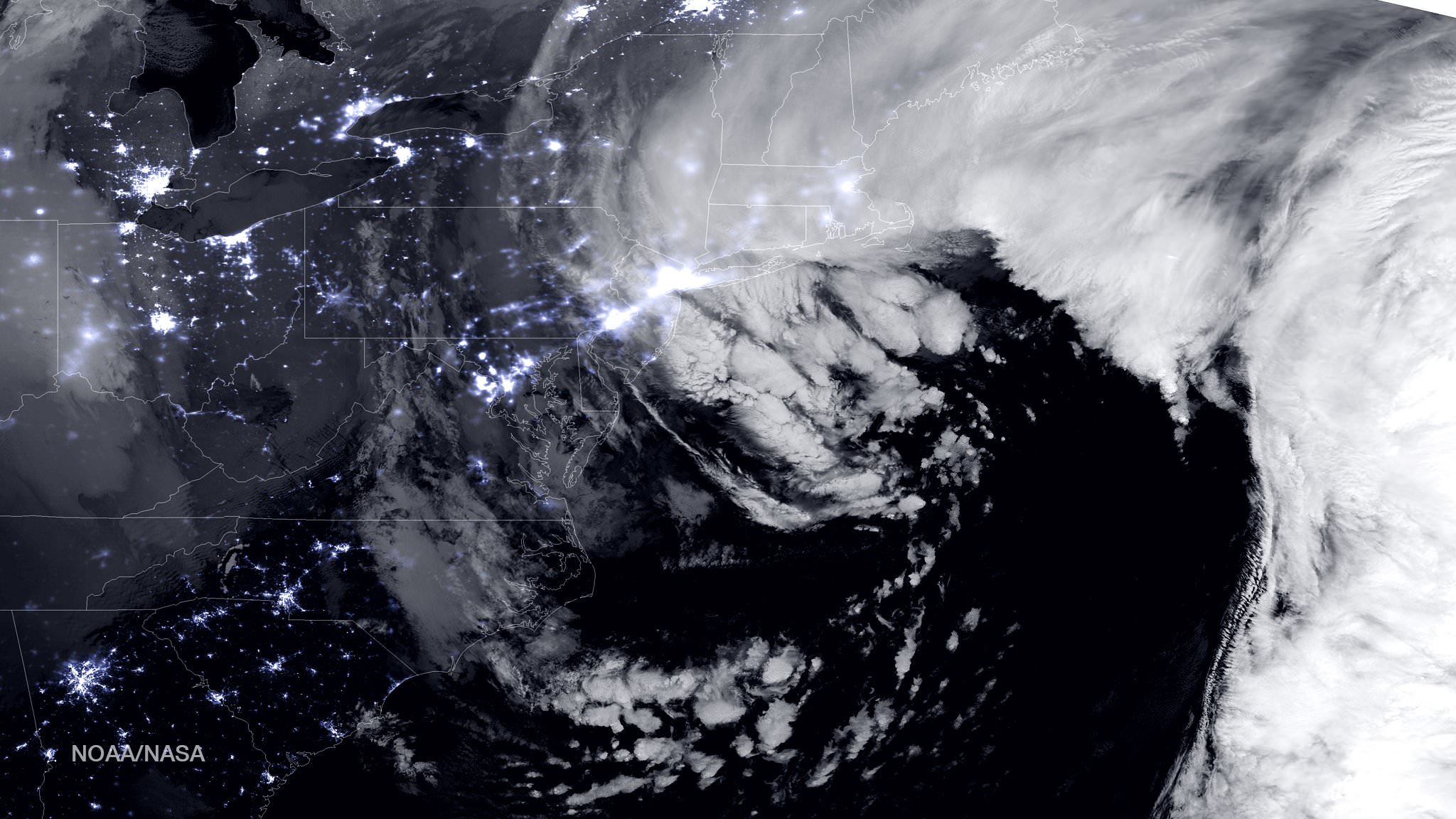
NASA-NOAA Suomi NPP satellite captures blizzard near peak intensity as it moves over New York and Boston regions at 1:45 am EST, Jan. 27, 2015. This view is a combination of the day-night band and high resolution infrared imagery from Suomi NPP showing the historic blizzard near peak intensity as it moves over the New York through Boston Metropolitan areas at 06:45Z (1:45 a.m. EST) on January 27, 2015. Credit: NOAA/NASA

NEW JERSEY – Record breaking snow from the ‘Blizzard of 2015’ hit vast regions of the US Northeast today, Jan. 27, 2015, stretching from Long Island to New England.

NASA and NOAA Earth orbiting satellites are keeping track of the storm affecting millions of residents.

This afternoon the agencies provided a new set of night-time and daytime views of the Blizzard of 2015 taken by the Suomi NPP and the GOES-East satellites.

The crippling blizzard is causing misery, extensive destruction to homes and businesses in localized areas, power outages, traffic accidents, breaks in some sea walls and deaths.

The satellite image above shows a combination of the day-night band and high resolution infrared imagery from the NASA-NOAA’s Suomi NPP satellite.

It was taken as the historic blizzard neared peak intensity as it moved over the New York area and through the Boston Metropolitan areas at 06:45Z (1:45 a.m. EST) on January 27, 2015.

The high cloud tops from the most intense parts of the storm blurred the regions normally bright nighttime lights in the satellite image.

Although the snow totals were about half the over two feet forecast for the New York Metropolitan region, many areas to the north and east were inundated with very heavy to historic snow fall totals, as bad or worse than the forecasters predicted.

Over two feet of snow fell on areas of New York’s Long Island and stretching north to vast regions of Connecticut, Massachusetts, New Hampshire and into Maine.

Near hurricane force waves are crashing into some coastal towns along the Massachusetts shoreline. Wind gusts as high as 78 mph have been recorded.

“Highest snowfall report has been Auburn, MA with 32.5 inches! Wind gust reports as high as 78 mph in Nantucket, MA,” according to a tweet this evening from the National Weather Service (NWS).

Worchester, Mass had a record breaking 31 inches of snow. And it’s still falling this evening in the 2nd largest city in New England.

A flood emergency is in effect in Marshfield, Mass., where an 80 foot section of the seawall was smashed by crashing waves and is destroying homes as shown on NBC Nightly News.

Blinding snow is raging in Portland, Maine this evening according on a live NBC News report.

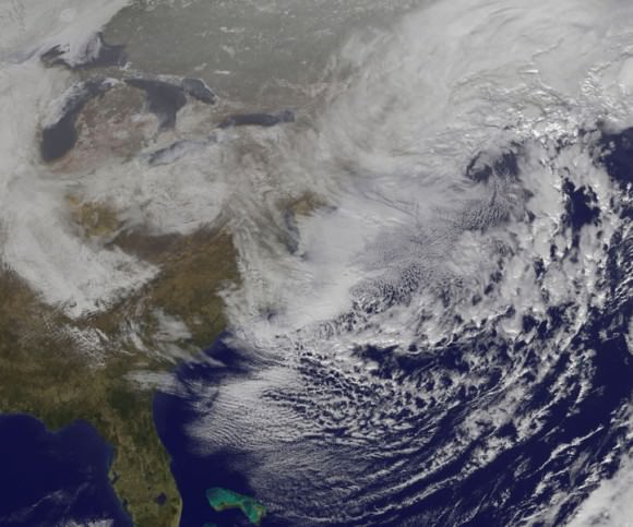
On January 27, 2015 at 17:35 UTC (12:35 p.m. EST) NOAA's Geostationary Operational Environmental or GOES- East satellite captured an image of the nor'easter over New England. Credit: NASA/NOAA GOES Project
On January 27, 2015 at 17:35 UTC (12:35 p.m. EST) NOAA’s Geostationary Operational Environmental or GOES- East satellite captured an image of the nor’easter over New England. Credit: NASA/NOAA GOES Project

“At 10 a.m. EST, the National Weather Service noted “the powerful nor’easter that brought moderate to heavy snowfall and blizzard conditions to the Northeast on Monday will continue to affect the region on Tuesday, with heavy snow and blizzard conditions expected from eastern Long Island to Maine as the system slowly moves to the northeast. Snow and strong winds will being tapering off from south to north Tuesday night into Wednesday morning,” wrote NASA’s Rob Gutro of NASA’s Goddard Space Flight Center in an update.

“Later on January 27, 2015 at 17:35 UTC (12:35 p.m. EST) NOAA’s Geostationary Operational Environmental or GOES-East satellite captured an image of the nor’easter over New England. The image was created by the NASA/NOAA GOES Project and showed the clouds associated with the nor’easter blanketing New England. An occluded front extended north and eastward out of the low pressure area’s center out into the Atlantic Ocean.”

The latest NOAA forecast as of 4 PM, Jan. 27 states:

HIGH WINDS AND HEAVY SNOW WILL BEGIN TO GRADUALLY TAPER OFF FROM SOUTH TO NORTH TONIGHT…BUT WILL LAST INTO EARLY WEDNESDAY MORNING ACROSS PORTIONS OF MAINE. HEAVY SNOWFALL WILL COMBINE WITH SUSTAINED WINDS OF 30 TO 40 MPH…AND GUSTS IN EXCESS OF 50 MPH…TO CREATE LIFE-THREATENING WHITEOUT OR BLIZZARD CONDITIONS. THESE WINDS MAY LEAD TO DOWNED TREES AND POWER LINES RESULTING IN POWER OUTAGES. TRAVEL WILL BE IMPOSSIBLE AND LIFE-THREATENING IN MANY AREAS. ALONG THE IMMEDIATE COASTLINE…WIND GUSTS TO NEAR 65 MPH WILL BE POSSIBLE. COASTAL FLOODING AND SEVERE BEACH EROSION WILL ALSO BE A POSSIBILITY…AND VULNERABLE ROADS AND STRUCTURES MAY BE FLOODED OR DAMAGED.

Stay tuned here for Ken’s continuing Earth and planetary science and human spaceflight news.

Reporting from snowy New Jersey.

Ken Kremer

NASA’s Next Exoplanet Hunter Moves Into Development

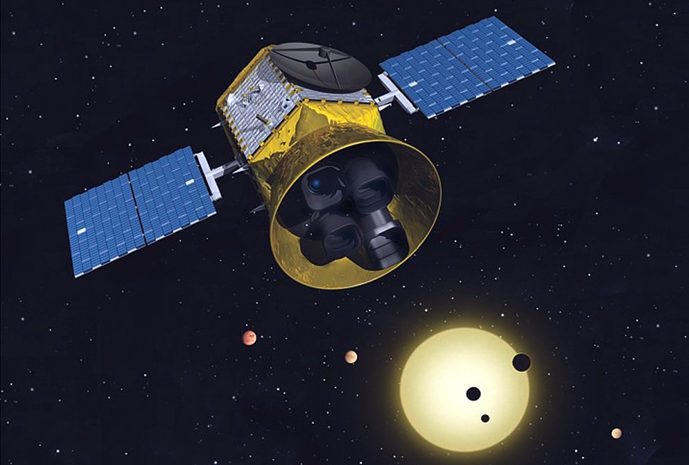
A conceptual image of the Transiting Exoplanet Survey Satellite. Image Credit: MIT

NASA’s ongoing hunt for exoplanets has entered a new phase as NASA officially confirmed that the Transiting Exoplanet Survey Satellite (TESS) is moving into the development phase. This marks a significant step for the TESS mission, which will search the entire sky for planets outside our solar system (a.k.a. exoplanets). Designed as the first all-sky survey, TESS will spend two years of an overall three-year mission searching both hemispheres of the sky for nearby exoplanets.

Previous sky surveys with ground-based telescopes have mainly picked out giant exoplanets. In contrast, TESS will examine a large number of small planets around the very brightest stars in the sky. TESS will then record the nearest and brightest main sequence stars hosting transiting exoplanets, which will forever be the most favorable targets for detailed investigations. During the third year of the TESS mission, ground-based astronomical observatories will continue monitoring exoplanets identified by the TESS spacecraft.

“This is an incredibly exciting time for the search of planets outside our solar system,” said Mark Sistilli, the TESS program executive from NASA Headquarters, Washington. “We got the green light to start building what is going to be a spacecraft that could change what we think we know about exoplanets.”

“During its first two years in orbit, the TESS spacecraft will concentrate its gaze on several hundred thousand specially chosen stars, looking for small dips in their light caused by orbiting planets passing between their host star and us,” said TESS Principal Investigator George Ricker of the Massachusetts Institute of Technology..

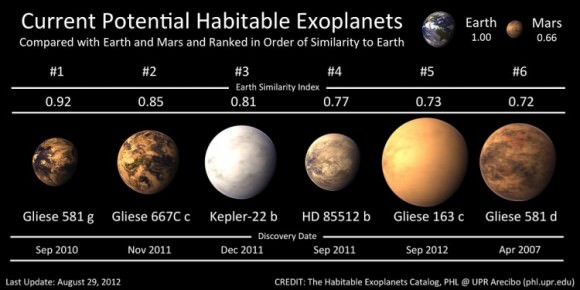
Artistic representations of the only known planets around other stars (exoplanets) with any possibility to support life as we know it. Credit: Planetary Habitability Laboratory, University of Puerto Rico, Arecibo.
Artistic representations of known exoplanets with any possibility to support life. Image Credit: Planetary Habitability Laboratory, University of Puerto Rico, Arecibo.

All in all, TESS is expected to find more than 5,000 exoplanet candidates, including 50 Earth-sized planets. It will also find a wide array of exoplanet types, ranging from small, rocky planets to gas giants. Some of these planets could be the right sizes, and orbit at the correct distances from their stars, to potentially support life.

“The most exciting part of the search for planets outside our solar system is the identification of ‘earthlike’ planets with rocky surfaces and liquid water as well as temperatures and atmospheric constituents that appear hospitable to life,” said TESS Project Manager Jeff Volosin at NASA’s Goddard Space Flight Center in Greenbelt, Maryland. “Although these planets are small and harder to detect from so far away, this is exactly the type of world that the TESS mission will focus on identifying.”

Now that NASA has confirmed the development of TESS, the next step is the Critical Design Review, which is scheduled to take place in 2015. This would clear the mission to build the necessary flight hardware for its proposed launch in 2017.

“After spending the past year building the team and honing the design, it is incredibly exciting to be approved to move forward toward implementing NASA’s newest exoplanet hunting mission,” Volosin said.

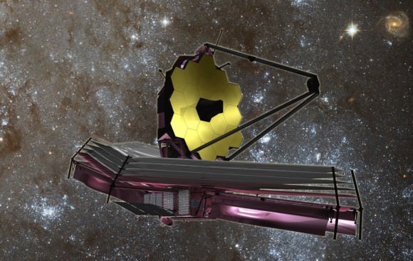
TESS is designed to complement several other critical missions in the search for life on other planets. Once TESS finds nearby exoplanets to study and determines their sizes, ground-based observatories and other NASA missions, like the James Webb Space Telescope, would make follow-up observations on the most promising candidates to determine their density and other key properties.

The James Webb Space Telescope. Image Credit: NASA/JPL

By figuring out a planet’s characteristics, like its atmospheric conditions, scientists could determine whether the targeted planet has a habitable environment.

“TESS should discover thousands of new exoplanets within two hundred light years of Earth,” Ricker said. “Most of these will be orbiting bright stars, making them ideal targets for characterization observations with NASA’s James Webb Space Telescope.”

“The Webb telescope and other teams will focus on understanding the atmospheres and surfaces of these distant worlds, and someday, hopefully identify the first signs of life outside of our solar system,” Volosin said.

TESS will use four cameras to study sections of the sky’s north and south hemispheres, looking for exoplanets. The cameras would cover about 90 percent of the sky by the end of the mission.

This makes TESS an ideal follow-up to the Kepler mission, which searches for exoplanets in a fixed area of the sky. Because the TESS mission surveys the entire sky, TESS is expected to find exoplanets much closer to Earth, making them easier for further study.

In addition, Ricker said TESS would provide precision, full-frame images for more than 20 million bright stars and galaxies.

“This unique new data will comprise a treasure trove for astronomers throughout the world for many decades to come,” Ricker said.

Now that TESS is cleared to move into the next development stage, it can continue towards its goal of being a key part of NASA’s search for life beyond Earth.

“I’m still hopeful that in my lifetime, we will discover the existence of life outside of our solar system and I’m excited to be part of a NASA mission that serves as a key stepping stone in that search,” Volosin said.

Further Reading: NASA

Just In Time for Halloween: Jupiter Gets a Giant Cyclops Eye!

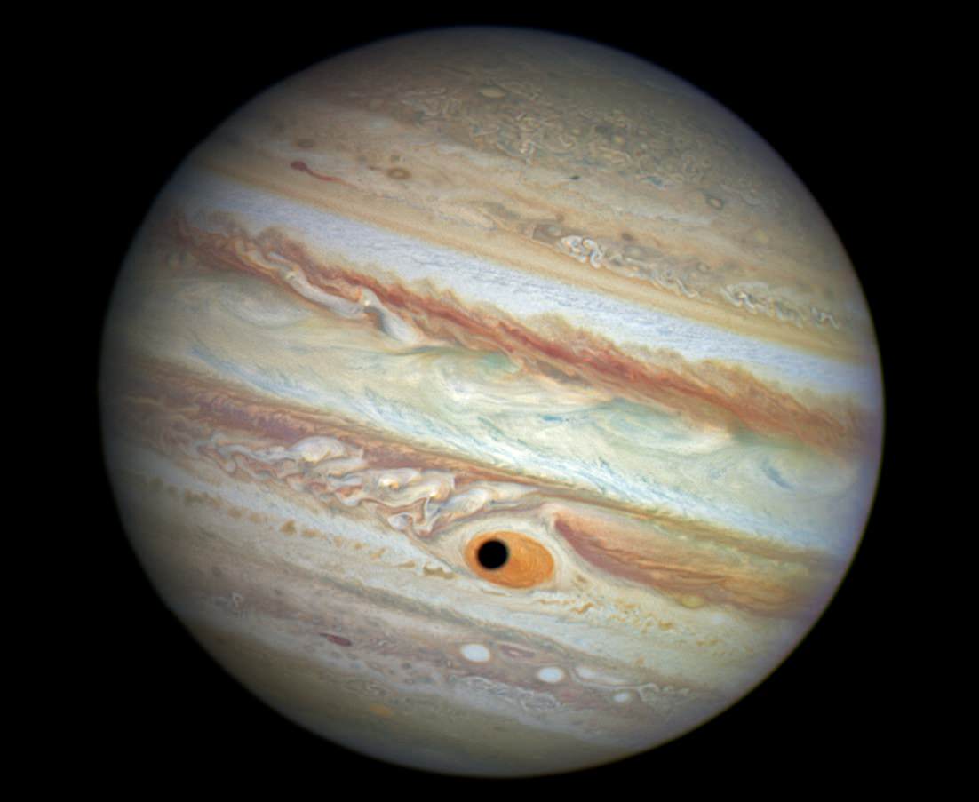
Jupiter's Great Red Spot and Ganymede's Shadow. Image Credit: NASA/ESA/A. Simon (Goddard Space Flight Center)

Halloween is just around the corner. And in what appears to be an act of cosmic convergence, Hubble captured a spooky image of Jupiter staring back at us with a cyclops eye!

While this is merely a convenient illusion caused by the passage of Ganymede in front of Jupiter – something it does on a regular basis – the timing and appearance are perfect.

Continue reading “Just In Time for Halloween: Jupiter Gets a Giant Cyclops Eye!”