HiRISE image of Curiosity’s tracks, landing zone and the MSL rover at John Klein outcrop (NASA/JPL/University of Arizona)
As Curiosity prepares for the historic first drilling operation on Mars, the HiRISE camera aboard the Mars Reconnaissance Orbiter captured an image of it from 271 km (169 miles) up, along with twin lines of tracks and the blast marks from the dramatic rocket-powered descent back on August 6 (UTC).
The image here was acquired on Jan. 13, Sol 157 of the MSL mission, as part of a dual HiRISE/CRISM observation of the landing site. According to The University of Arizona’s HiRISE site it’s the first time the rover’s tracks have been imaged in color.
Her original landing site can be seen at the right edge. (Wait… did I just say “her?”)
The pair of bright white spots in the HiRISE image show the area immediately below where sky crane’s rockets were pointed. Those areas were “blasted clean” and therefore show brightest. The larger dark scour zone is dark because the fine dust has been blown away from the area leaving darker materials.
– Ross A. Beyer, UofA HiRISE team
Curiosity can be seen as she (yes, it was confirmed today during ScienceOnline2013 that the rover — like all exploration vehicles — is a girl) was preparing for drilling into a rock outcrop called John Klein within the “Yellowknife” region in Gale Crater. Drilling is expected to begin today, Jan. 31.
Orbital view (detail) of Curiosity at her drilling site in Yellowknife. Image was rotated so north is up. (NASA/JPL/University of Arizona)
Read more about the first drilling to be performed on Mars in this article by Ken Kremer, and see more news from the MSL mission here.
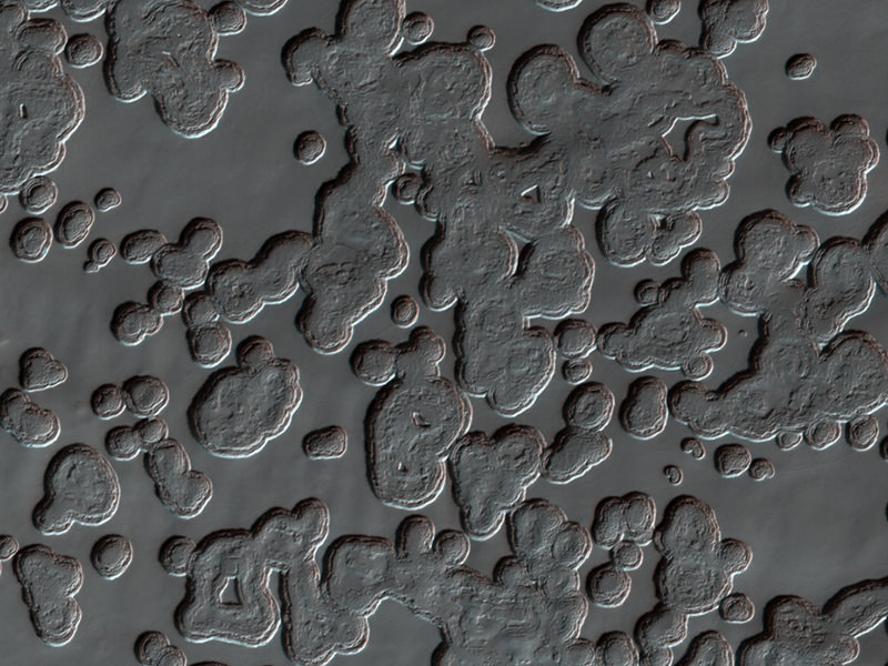
Eek, spiders! All right, so it’s not actually little green arachnids we’re talking about here, but they are definitely spidery features. Called araneiform terrain, these clusters of radially-branching cracks in Mars’ south polar surface are the result of the progressing spring season, when warmer temperatures thaw subsurface CO2 ice.
As dry ice below the surface warms it can sublimate rapidly and burst through the frozen ground above, creating long cracks. If the material below is dark it can be carried upwards by the escaping gas, staining the surface.
Each dark splotch is around 100 meters wide.
This image was acquired by the HiRISE camera aboard NASA’s Mars Reconnaissance Orbiter on September 26, from a distance of 262 km (163.8 miles). See the full-size scan here, and check out more recent HiRISE images in the November PDS release here.
Here’s a look down at Curiosity from the HiRISE camera aboard NASA’s Mars Reconnaissance Orbiter, orbiting approximately 200 km (125 miles) above the surface of Mars. This new image, released today, shows the rover inside Gale Crater surrounded by a skirt of blue-tinted material, including several bright radiating marks –the result of the descent stage rockets clearing layers of dust from the surface.
In this exaggerated-color view the blue indicates material of a different texture and composition than the surrounding area. HiRISE captures images in visible light wavelengths as well as near-infrared, which we can’t see. To us, the blue material would look grey.
North is up, and Curiosity’s ultimate exploration target, Gale Crater’s central peak, Mount Sharp, is off frame to the lower right.
Click here for a full-size version of the HiRISE image scan, showing the scene above plus some areas further north and south — including portions of the dark dune fields visible in recent images from Curiosity.
It’s nice to know that Curiosity has friends in high places!
One of the “weirdest and least understood” areas of Mars, the enormous Hellas Impact Basin contains strange flowing landforms that bespeak of some specialized and large-scale geologic process having taken place. The HiRISE camera aboard NASA’s Mars Reconnaissance Orbiter recently captured the image above, showing what’s being called “lava lamp terrain” — stretched and contorted surface that looks like overworked modeling clay or pulled taffy… or, with a bit of imagination, the melted, mesmerizing contents of a party light from another era.
At 1,400 miles (2,300 km) across, Mars’ Hellas Basin is one of the largest impact craters in the entire Solar System. Its vast interior sinks to a depth of about 23,000 feet (7152 meters) below Mars’ average surface elevation (Martian “sea level”, if you will) and thus its floor is often shrouded by haze and dust, making visual imaging difficult.
The “lava lamp” terrain is just one of many different types of landforms that are found in the basin, although many of these banded features are found in the northwest area — which is also the deepest part of the basin. If there had been water in the region at some point in the planet’s history, it would have concentrated there.
Although the texture at first appears as if it could be volcanic in origin, it’s thought that flowing water or ice may actually be the source.
Researchers are currently working to determine how the Hellas Basin became so smoothly sculpted. Nicolas Thomas, Professor of Experimental Physics at the University of Bern, Switzerland, told Universe Today:
“There are a lot of very interesting images from this area and we are trying to get more data (including stereo) to understand better what’s going on and to try to establish what process is responsible for the numerous bizarre features we see. We are hoping to make some more progress in the next few months.”
Example of banded terrain. Compare the relatively fresh appearance of the bands with the older terrain seen to the left of this sub-image. (NASA/JPL/University of Arizona/N. Thomas et al.)
“Together with the observations of isolated areas and the lack of obvious caldera(s), it is difficult to envisage a volcanic origin for these features and we currently tend towards a mechanism involving ice,” Thomas stated in an abstract of a presentation given at the Europlanet Conference in 2010.
Read the full abstract here, and see this and more high-resolution images from Mars on the HiRISE website.
The dark sand of this barchan dune changes position between June 15, 2008 and May 21, 2010. (Click to play.)
[/caption]
The benefit of long-term observations from orbit became evident today with the release of images from NASA’s Mars Reconnaissance Orbiter showing the subtly shifting motion of large sand dunes on the red planet, proving that the surface of Mars is much more dynamic than previously believed!
The atmosphere of Mars is extremely thin – only 1% as dense as Earth’s. This means that Martian winds would seem barely perceptible to a human, and has to blow at high speeds to move even the smallest particles on its surface.
Although scientists have known that Mars contains many dunes and vast expanses of sandy regions it has been assumed that these features must move very slowly – if at all – due to the thin air.
“We used to think of the sand on Mars as relatively immobile, so these new observations are changing our whole perspective.”
– Nathan Bridges, lead author
A rippled dune near Herschel crater undulates in the thin Martian wind. (Click to play.)
Now, images taken at different intervals by the MRO’s HiRISE camera have been seen to clearly show the shifting motion of several large sand dune features (called bedforms) in various locations on Mars.
“Mars either has more gusts of wind than we knew about before, or the winds are capable of transporting more sand,” said Nathan Bridges, planetary scientist at the Johns Hopkins University’s Applied Physics Laboratory and lead author of a paper published online in the journal Geology. “We used to think of the sand on Mars as relatively immobile, so these new observations are changing our whole perspective.”
Sandy particles on Earth that could be moved by a 10 mph breeze would require an 80 mph gust of Martian wind. Weather data and climate models have shown that such winds should be rare on Mars; these recent findings by MRO indicate that either high-speed winds are more common than once thought or else they are more capable of moving sand around… or a combination of both!
Not all of Mars’ dunes are so restless, though. The study showed that there are regions that show no movement.
“The sand dunes where we didn’t see movement today could have larger grains, or perhaps their surface layers are cemented together,” Bridges said. “These studies show the benefit of long-term monitoring at high resolution.”
Ten years ago the belief was that dunes on Mars are either static or move too slowly to detect. Thanks to MRO and the HiRISE team – and the authors of this new paper – we now know that idea is all just dust in the wind.
The streak on Google Mars misinterpreted as a secret Mars base.
[/caption]
It’s time for another episode of “Conspiracy Theory of the Week.” This one involves a supposed secret space station on Mars. The You Tube video showing “Bio Station Alpha” (below) went viral and was even reported on some mainstream media outlets. The station is supposedly a 700 ft x 150 ft structure on Mars and by some accounts is colored white with blue and red stripes. It was found on Google Mars by an “armchair astronaut” and breathless conspiracy bloggers have touted this as the most important discovery on Mars yet, and “proof!” that NASA is hiding their activities.
In reality, this is not a space station, a Mars base or any type of structure – created or natural — on the surface of the Red Planet. What shows up in this location on Google Mars is just a smattering of about 11 bad pixels from data dropout – a linear streak artifact likely caused by a cosmic ray hitting the Mars Express spacecraft while it was taking the image – and then that smudge has been badly distorted through image processing when it became part of Google Mars.
Here’s the image that is seen on Google Mars after processing, which includes very noticeable compression artifacts:
And now here’s the original image taken by the Mars Express High Resolution Stereo Camera image (H5620_0000_ND), taken on May 18, 2008 (and here’s the link to the original image):
Original Mars Express HRSC image of the location in question on Mars. Credit: ESA
This image really makes it clear this is an image artifact from a cosmic ray hit.
Here’s the same location taken by the MRO Context Camera (CTX) on January 25, 2010 (a crop of the same location as seen above from the original large CTX image, available here):
MRO's Context Camera (CTX) image MRO CTX B17_016407_2528_XN_72N029W of the same location. Credit: MSSS
In this image, each pixel represents a distance of about 6.25 meters, a higher resolution than what is available from the Mars Express spacecraft, which takes images at 10 meters per pixel. Obviously, there is no structure or anything unusual at that location, except for the northern polar sand dunes.
Harrison explained that the CTX acquires grayscale (black & white) images at 6 meters per pixel scale over a swath 30 kilometers wide and provides context images for the MRO HiRISE and CRISM cameras, which can take even higher resolution images. It is used to monitor changes occurring on the planet, and help the science team select critical science targets. The team at Malin Space Science Systems pores over the images looking for anything unusual. In this case, at this location, they found nothing.
“Every day, the images we acquired with CTX and MARCI the previous day are inspected by multiple sets of eyes,” Harrison told Universe Today. “We look at every single image for multiple reasons: checking the health of the instrument, monitoring weather conditions for future targeting of the cameras, and looking for anything geologically interesting.”
Harrison added that nearly all the operations folks on the team have Master’s degrees or Ph.D.s in geology or a related field.
“If we spot anything out of the ordinary, we look at previous images of the area, not just from CTX and MARCI, but from the Mars Global Survery’s Mars Orbiter Camera, the THEMIS VIS and IR on the Mars Odyssey spacecraft, the HRSC on Mars Express, and Viking,” Harrison said. “This lets us look at the features at different illumination angles, times of day, resolutions, etc. We know better than to speculate on something below the resolution of our cameras, so if we see something in CTX that’s worth following up on at a higher resolution, we ask HiRISE to shoot it. The same thing was true for MOC, following up on things observed in the low-resolution wide angle images with high-resolution narrow angle images.”
Clearly, this region has been imaged and examined previously, with absolutely nothing found by the top experts in the field. The region is so uninteresting that no one has requested for HiRISE — which can take images of 1-2 meters per pixel — to take any images of this area.
Harrison said CTX takes images of Mars that are up to 30 km wide and over 300 km long at a very high resolution. “This is a pretty big footprint with a relatively high resolution compared to previous cameras!” she said. “The size of that footprint has allowed us to cover over 60% of Mars at 6 meters per pixel in the 5 years MRO has been orbiting Mars. In addition to mapping, we use CTX to acquire stereo coverage of key areas, as well as to monitor hundreds of locations on Mars for changes such as new impact craters and dust activity.”
If there were something unusual on Mars, the people at NASA, ESA, MSSS and anyone monitoring Mars would have imaged this site repeatedly with the best cameras available. They would love to find something unusual, groundbreaking and front-page worthy, and if they did would be shouting it from the rooftops, not hiding it.
Pitted "swiss cheese" terrain at Mars' south pole hints at sublimation of underground CO2
[/caption]
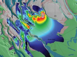
Scientists have spotted an underground reservoir near Mars’ south pole the size of Lake Superior… except that this lake is filled with frozen carbon dioxide – a.k.a. “dry ice”!
A recent report by scientists at the Southwest Research Institute in Boulder, CO reveals variations in Mars’ axial tilt can change how much carbon dioxide gets released into the atmosphere, affecting factors from the stability of water on its surface to the power and frequency of dust storms.
Thickness Map of Buried CO2 Ice Deposit
The Mars Reconnaissance Orbiter’s ground-penetrating Shallow Radar identified a subsurface deposit of frozen material, confirmed as carbon dioxide ice by its radar signature and visual correlation to the surface pitting seen above. As the polar surface warms during the Martian spring, underground CO2 deposits evaporate (or “sublime”) leaving behind round depressions in the frozen ground. (This has been aptly dubbed “swiss cheese terrain” by researchers on the HiRISE imaging team.)
While scientists were aware of seasonal CO2 ice layers atop the water ice this new discovery brings to light nearly 30 times more frozen CO2 than was previously believed to exist. In fact this particular deposit alone contains 80% the amount of CO2 currently present in the planet’s entire atmosphere.
The importance of this finding is how the carbon dioxide ultimately affects the global Martian climate as it freezes and thaws. When the CO2 is frozen and locked away in subsurface deposits like this, it’s not free to enter the atmosphere and do what CO2 does best: warm the planet… as well as increase atmospheric pressure. This means that liquid water cannot last as readily on the surface since it will either freeze or boil away. Also with less air pressure the strength of wind is decreased, so dust storms are less frequent and less severe.
When factored in with the axial tilt difference – and thus variations in the amount of sunlight hitting the poles – researchers’ models show that Mars’ average atmospheric pressure may at times be 75% higher than it is today.
These shifts in the orientation of the Red Planet’s axis occur on 100,000-year intervals… long by human standards but geologically very frequent. Mars may have had liquid water existing on its surface fairly recently!
Mars' south polar ice cap, seen in April 2000 by Mars Odyssey. NASA/JPL/MSSS
Although this may sound that Mars has had its own share of global warming due to CO2 emissions in its history, it must be remembered that Mars and Earth have very different atmospheric compositions. Earth’s atmosphere is much thicker and denser than Mars’, so even when doubling its CO2 content Mars’ atmosphere is still too thin and dry to create a strong greenhouse effect… especially considering that the polar caps on Mars increase cooling more than additional CO2 in the atmosphere raises global temperature. Without oceans and atmosphere to collect and distribute heat, the effect of any warming quickly radiates out into space…and eventually the planet swings back into a freeze-dried state.
“Unlike Earth, which has a thick, moist atmosphere that produces a strong greenhouse effect, Mars’ atmosphere is too thin and dry to produce as strong a greenhouse effect as Earth’s, even when you double its carbon-dioxide content.”
– Robert Haberle, planetary scientist at NASA’s Ames Research Center
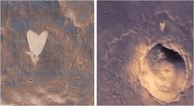
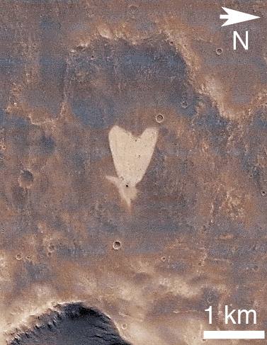
A heart-shaped feature in the Arabia Terra region of Mars is show on the left, with additional context on the right, in excerpts of an image taken by the Context Camera on NASA's Mars Reconnaissance Orbiter. Image Credit: NASA/JPL-Caltech/MSSS
[/caption]
Happy Valentine’s Day from Mars to all the readers of Universe Today !
Well it’s truly a solar system wide Valentines celebration. From the Moon, Mars and even Comet Temple 1 with some pixie Stardust for the romantic rendezvous upcoming in a few short hours [Stardust-NExT Flyby at 11:37 p.m. EST Feb 14].
The Martian camera team from Malin Space Systems, San Diego, wishes to share a special heart-shaped feature from Arabia Terra – images above and below – with all Mars fans on this St. Valentine’s Day, Feb. 14, 2011. And certainly, I love Mars ! Especially those gorgeous and brainy twin gals Spirit & Opportunity.
Heart-shaped feature in Arabia Terra on Mars at 21.9 degrees north latitude, 12.7 degrees west longitude. Credit: NASA/JPL-Caltech/MSSS.The image was taken on May 23, 2010 – at the start of northern summer on Mars – by the Malin-built and operated Context Camera on NASA’s Mars Reconnaissance Orbiter.
The bright heart shaped feature is about 1 kilometer (0.6 mile) long. Arabia Terra lies in the northern hemisphere of Mars
The tip of the heart lies above a small impact crater centered at 21.9 degrees north latitude, 12.7 degrees west longitude.
According to a JPL press release, “The crater is responsible for the formation of the bright, heart-shaped feature. When the impact occurred, darker material on the surface was blown away, and brighter material beneath it was revealed.
PIA13799: Heart-Shaped Feature in Arabia Terra (Wide View). Credit: NASA/JPL-Caltech/MSSS.Some of this brighter material appears to have flowed further downslope to form the heart shape, as the small impact occurred on the blanket of material ejected from a much larger impact crater.
The Jet Propulsion Laboratory, Pasadena, Calif manages MRO for NASA.
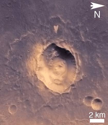
More Martian hearts images below from another Malin built camera aboard NASA’s Mars Global Surveyor orbiter
Happy Valentines Day from Mars Global Surveyor (MGS)
This heart shaped pit on Mars is located on the east flank of the Alba Patera volcano in northern Tharsis. The pit was formed by collapse within a straight-walled trough known in geological terms as a graben. Graben are formed along fault lines by expansion of the bedrock terrain. Credit: NASA/JPL-Caltech/MSSS. 10 Martian Hearts for Valentine’s Day.
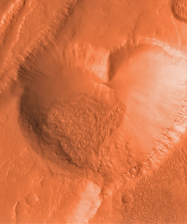
Mesas and depressions from all across Mars. Images taken by Mars Global Surveyor from 2001 to 2004. Credit: NASA/JPL-Caltech/MSSS. Heart shaped landforms on Mars – or perhaps a box of chocolates !
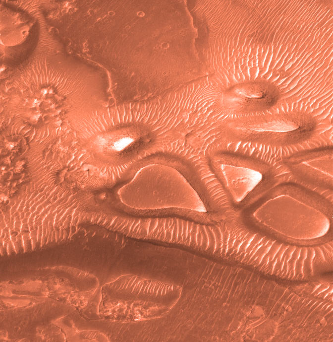
Image taken by Mars Global Surveyor. Credit: NASA/JPL-Caltech/MSSS
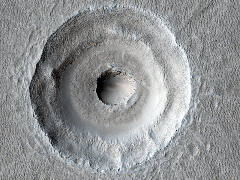
Bull's-Eye Impact Crater. Credit: NASA/JPL/University of Arizona
[/caption]
Here’s some doses of coolness and craziness for your Friday. This top image is one of the latest from the HiRISE camera on the Mars Reconnaissance Orbiter, and shows what looks like a target on the Red Planet. Researchers from the HiRISE team aren’t sure yet whether this is two impacts — one impact that occurred dead center within another — or just unusual subsurface layering within one impact. I’m voting for two impacts, just because it is such a cool, lightning-strikes-twice concept. While no ejecta from the interior crater can be seen, the team says the ejecta could have been removed by extensive periglacial modification. Additionally, the floor fill around the inner crater resembles impact ejects elsewhere at this latitude, and some of the “landslides” to the East could be flow-back of ejecta off the walls of the larger crater. Likely the team will be looking closer at this impact to sort out the history and likelihood of a double impact. (UPDATE: I just saw that the Bad Astronomer has posted a more detailed CSI into this image, which you should read!)
Now, this next one is the crazy part…
Mars industrial site with (a) nozzle spray and (b,c) domes. Credit: NASA, annotations from Farsight Institute, via the SciGuy.
There’s a guy, and apparently a team of “remote viewing experts” who have found what they believe is a massive industrial complex on Mars. Eric Berger at his SciGuy blog at the Houston Chronicle wrote about this today, and it is just way too wacky to believe, kind of like the people who zoom in on rocks on Mars and say they see Bigfoot. Anyway, these folks say they can even tell that there are artificial structures at this site with a laboratory. What’s more they can see that there are lifeforms there wearing uniforms, and there are more men than women. Yep.
This image shows a river that sprang from a past glacier from an unnamed crater in Mars’ middle latitudes. Credit: NASA/JPL/MSSS
[/caption]
No sooner do we post one article about water on Mars when it’s time for another. Planetary scientists have uncovered telltale signs of water on Mars — frozen and liquid — in the earliest period of the Red Planet’s history. They found evidence of running water that sprang from glaciers throughout the Martian middle latitudes as recently as the Amazonian epoch, several hundred million years ago. These glaciofluvial valleys were, in essence, tributaries of water created when enough sunlight reached the glaciers to melt a thin layer on the surface. This led to “limited surface melting” that formed channels that ran for several kilometers and could be more than 150 feet wide.
The finding is “more than ‘Yes, we found water,’” said Caleb Fassett from Brown University, who along with Brown research analyst James Dickson, professor James Head III, and geologists from Boston University and Portland State University published a paper in Icarus. “What we see now is there’s this complex history of different environments where water is being formed.”
The team analyzed 15,000 images snapped by the Context Camera (CTX) aboard the Mars Reconnaissance Orbiter to compile the first survey of glaciofluvial valleys on Mars. The survey was sparked by a glaciofluvial valley that Dickson, Fassett, and Head spotted within the Lyot crater, located in the planet’s middle latitudes. The team, in a paper last year in Geophysical Research Letters, dated that meltwater-inspired feature to the Amazonian.
In his survey, Fassett found dozens of other Amazonian-era ice deposits that spawned supraglacial and proglacial valleys, most of them located on the interior and exterior of craters in Mars’ midlatitude belt. “The youthfulness (of the features) is surprising,” he said. “We think of [post-Noachian] Mars as really, really cold and really, really dry, so the fact that these exist, in those kinds of conditions, is changing how we view the history of water on the planet.”
What makes the finding even more intriguing is that the Brown planetary scientists can study what they believe are similar conditions on Earth. Teams from Brown and Boston University have visited the Antarctic Dry Valleys for years, where the surfaces of glaciers melt during the austral summer, sparking enough meltwater to carve a channel. The team will return to the Dry Valleys later this year to continue the study of this microclimate.
“It’s sort of crazy,” said Dickson, a member of the Brown team who stayed in the Dry Valleys for three months last year. “You’re freezing cold and there’s glacial ice everywhere, and it gets just warm enough that you get a river.”
Fassett plans to search for more glaciofluvial valleys as more images come from the CTX, which has mapped roughly 40 percent of the planet.

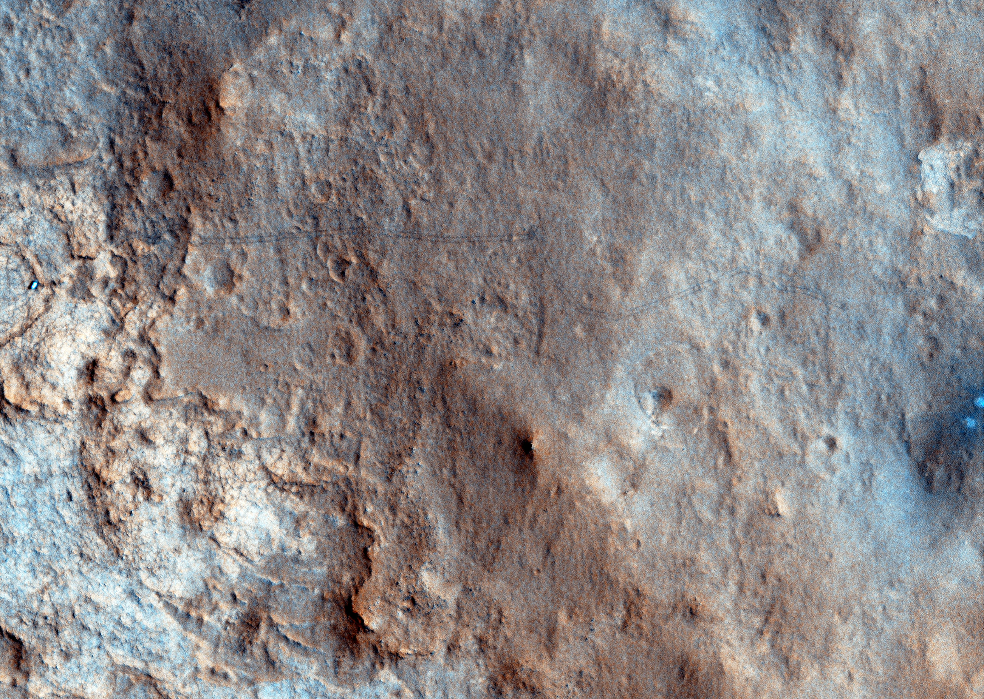
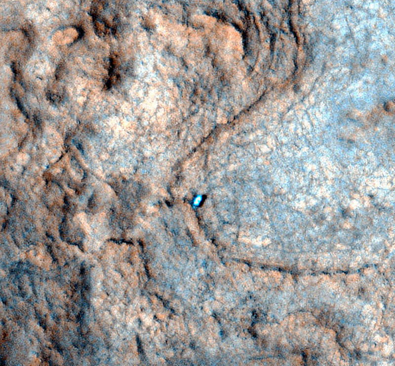


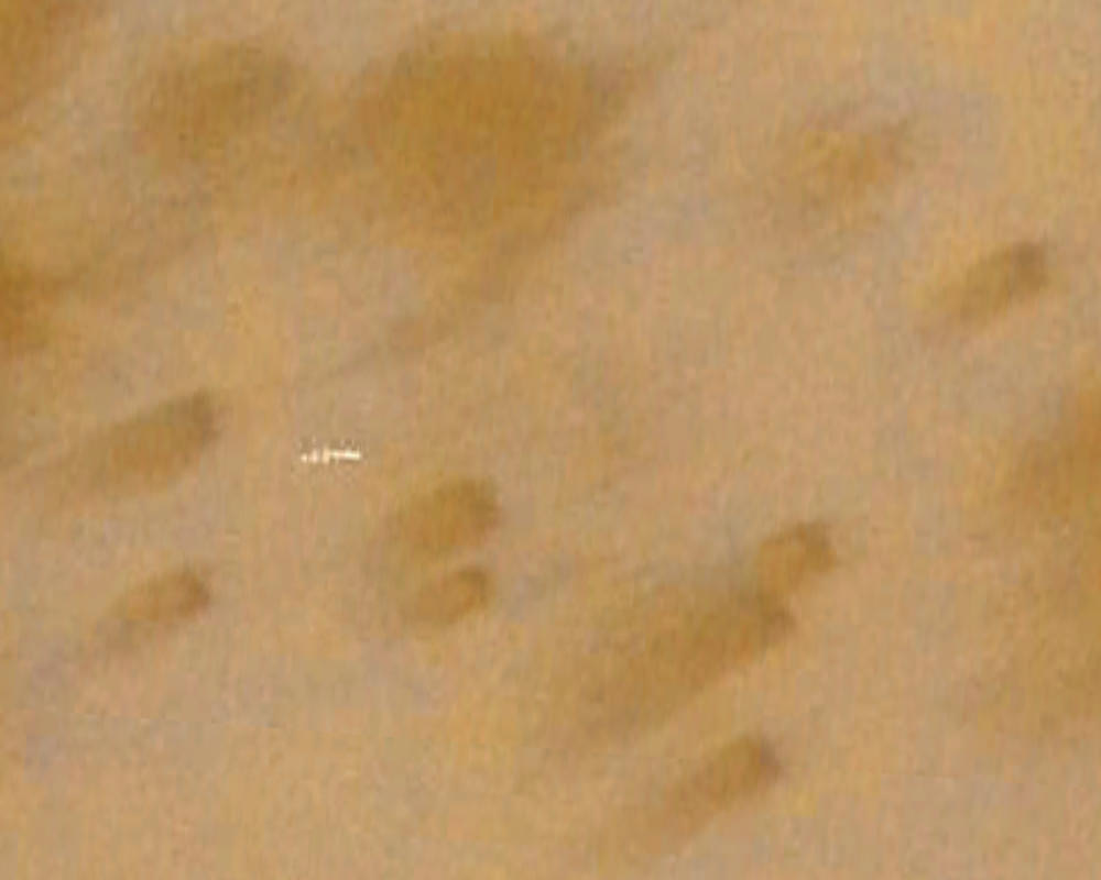

 image MRO CTX B17_016407_2528_XN_72N029W of the same location. Credit: MSSS")


 nozzle spray and (b,c) domes. Credit: NASA, annotations from Farsight Institute, via the SciGuy.")
