Mars Global Surveyor

Mars Global Surveyor

[/caption]

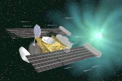
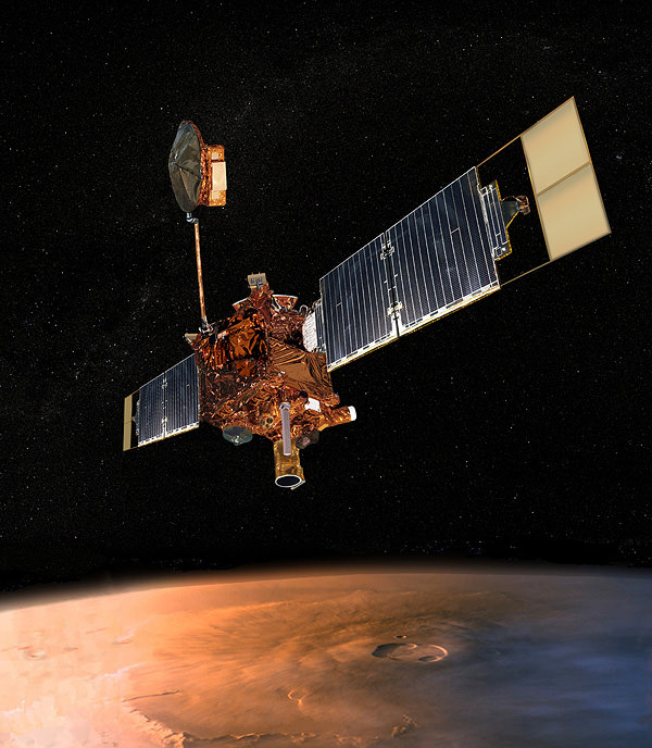
The Mars Global Surveyor was a spacecraft sent to Mars in 1996. It arrived at Mars and studied the planet for 10 years, until it broke down in 2006, and controllers on Earth lost contact with it. But while it was operating, the spacecraft took thousands of images, and made some major discoveries about Mars.

Mars Global Surveyor was launched on November 7, 1996, and made its orbital insertion on September 11, 1997. It used a technique called aerobraking to reduce its orbit and bring it into an orbit that brought it to an average distance of 378 km from the surface of Mars. It circled the planet in a polar orbit once every 117 minutes, which allowed it to photograph the entire Martian surface.

The spacecraft was equipped with 5 major scientific instruments: Mars Orbiter Camera, Mars Orbiter Laser Altimeter, Thermal Emission Spectrometer, Magnetometer and electron reflectometer and the Ultrastable Oscillator for Doppler measurements. These instruments allowed the spacecraft to study the atmosphere and surface composition of Mars. But it also sent back the highest resolution photographs ever seen of Mars. The newer Mars Reconnaissance Orbiter has returned better images with its larger telescope, but when the first MGS images first came back from Mars, they were stunning.

It made some incredible discoveries about Mars. Thanks to the observations from MGS, astronomers determined that Mars had a layered crust that was more than 10 km thick. It found ancient craters that had been buried and then later exposed by erosion, and it found evidence of ancient lava flows.

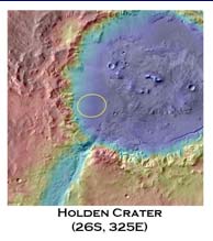
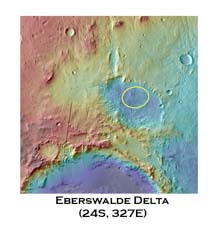
But perhaps the biggest discovery was made in 2006, which researchers announced that they had uncovered evidence of recent water activity on Mars. Images from the Mars Global Surveyor showed gullies on Mars which looked like they’d been formed by water. It’s possible that water had erupted out of an underground aquifer and spilled down the slope of a hill before evaporating in the pressure of the Martian atmosphere.

After a decade of service, Mars Global Surveyor went silent on November 2, 2006. It went into safe mode after being issued commands to change the orientation of its solar panels, and it stopped communicating. NASA said that it was, “battery failure caused by a complex sequence of events involving the onboard computer memory and ground commands.” But we’ll never really know what happened to it.

We’ve written many articles about the Mars Global Surveyor for Universe Today. Here’s an article about how we lost contact with the Mars Global Surveyor, and here’s a picture of Earth taken by MGS.

If you’d like more info, check out the Mars Global Surveyor homepage.

Source: NASA

Explore the Universe with Science@ESA

ESA Podcast #1 screenshot.

[/caption]

If you’re looking for some superb space and astronomy vodcasts, ESA has produced a series of informative video podcasts that explore our Universe as seen through the “eyes” of ESA’s fleet of science spacecraft. “The Science@ESA podcast series was started as part of an education and public outreach project for the International Year of Astronomy,” said Dr. Salim Ansari, from ESA’s Directorate of Science and Robotic Exploration, “but it will continue on past IYA, continuing to cover more missions and discoveries.”

The series is a high quality video podcast with HD graphics and stunning visuals. Ansari said the production all done in house.

“One of my favorites is actually the first podcast that shows how with our eyes we see just a small portion of the electromagnetic spectrum,” Ansari said. “But we demonstrate how the different spacecraft can provide insight across the whole spectrum.”
ESA podcast screenshot.
Other podcasts delve into specifics of the electromagnetic spectrum that will be explored by the new Planck (microwave) and Herschel (infrared) spacecraft, to learning about the Gaia galaxy mapper mission that will determine the position of a billion stars.

A new 7th podcast will be released next week that introduces the solar system as seen by the Venus Express, Mars Express, Rosetta, Cassini-Huygens, SoHO and Cluster.

See the Science@ESA page for a complete list of podcasts.

Deep Impact

NASA's Deep Impact probe hits Comet Tempel 1 (NASA)

[/caption]
Deep Impact is the name of a NASA space mission whose primary objective was to study Comet Tempel 1 (a.k.a. 9P/Tempel). It was launched on 12 January, 2005, and the smart impactor crashed into the comet on 4 July, 2005.

Oh, and yes, Deep Impact is also the name of a movie … but the two have no connection (the science team came up with their name independently of the Hollywood studio), other than that they both concern a comet!

Comets had been the focus of several space probes before Deep Impact, perhaps the most famous of which is the ESA’s Giotto flyby of Comet Halley. However, flybys could not, and cannot, tell us much about what’s beneath the cometary surface; in particular, what the relative amounts of ices and dust is, how porous the comet body is, and so on. The Deep Impact mission was designed to address many of these unknowns.

The space probe consisted of two parts, a 370 kg copper Smart Impactor – that smashed into the comet – and the Flyby section, which watched the impact from a safe distance. In addition, many ground-based telescopes – including those of thousands of amateurs – and some space-based ones, watched the event from an even safer distance.

The mission was a great success in that the heavy copper section did, in fact, smash into the comet, and the other section did observe the impact up-close-and-personal, but safely. A great deal was learned about this comet – its composition and mechanical strength, etc – and comets in general. However, the plume which resulted from the impact was much denser than expected, so the Flyby did not get any images of the impact crater itself.

After the encounter with Comet Tempel 1, an extended mission for the Flyby was designed and implemented, called EPOXI, after its two objectives: the Extrasolar Planet Observation and Characterization (EPOCh) and the Deep Impact Extended Investigation (DIXI) … hence Extrasolar Planet Observation and Deep Impact Extended Investigation. The former uses the larger telescope on the space probe to look for exoplanet transits; the latter is a flyby of another comet, Hartley 2, now expected on 11 October, 2010.

There are several official Deep Impact websites, including NASA’s, JPL’s (Jet Propulsion Laboratory), and the University of Maryland’s on EPOXI.

The Deep Impact mission resulted in lots of Universe Today stories, far too many to mention here. Some of the best are Deep Impact Smashes into Temple 1, What the Ground Telescopes Saw During Deep Impact, Deep Impact Turns Up Cometary Ice, and Deep Impact Begins Searching for Extrasolar Planets.

Comets, our Icy Friends from the Outer Solar System is a good Astronomy Cast episode which gives a good background on comets.

Source: NASA

Amazing Zoomable Poster on 50 Years of Space Exploration

Art by Sean McNaughton, National Geographics Staff; Sameul Velasco, 5@ infographics. Sources: NASA; Chris Gamble. Sund, asteroid and comet images: NASA/JPL

[/caption]
National Geographic has put together a really nice zoomable poster on the history of robotic space exploration. It looks a little psychedelic from a distance, but zoom right in and follow the different missions to the various locations in our solar system, and see where the missions currently underway — like New Horizons, on its way to Pluto, and the venerable Voyagers that we hear from occasionally– are presently located. Click on the image to go to National Geographic’s Map of the Day page. Enjoy!

LCROSS Team Changes Target Crater for Impact

LCROSS Mission
Artist impression of LCROSS approaching the Moon. Credit: NASA

[/caption]
Based on new analysis of the latest lunar data, the science team for NASA’s Lunar Crater Observation and Sensing Satellite mission (LCROSS) decided to change the target crater for impact from Cabeus A to Cabeus (proper). The decision was based on a consensus that Cabeus shows, with the greatest level of certainty, the highest hydrogen concentrations at the south pole. The most current terrain models provided by JAXA’s Kaguya spacecraft and the LRO Lunar Orbiter Laser Altimeter (LOLA) was important in the decision process, as the latest models show a small valley in an otherwise tall Cabeus perimeter ridge, which will allow for sunlight to illuminate the ejecta cloud, making it easier to see from Earth.

The decisison was based on continued evaluation of all available data and consultation/input from members of the LCROSS Science Team and the scientific community, including impact experts, ground and space based observers, and observations from (LRO), Lunar Prospector (LP), Chandrayaan-1 and JAXA’s Kaguya spacecraft. This decision was prompted by the current best understanding of hydrogen concentrations in the Cabeus region, including cross-correlation between the latest LRO results and LP data sets.

As for the sunlight illuminating the ejecta cloud on Oct. 9, it should show up much better than previously estimated for Cabeus. While the ejecta does have to fly to higher elevations to be observed by Earth telescopes and observers, a shadow cast by a large hill along the Cabeus ridge, provides an excellent, high-contrast, back drop for ejecta and vapor measurements.

See this link for how to observe the impact from Earth. Eastern and central north America has the best chance of seeing the impact.

The LCROSS team concluded that Cabeus provided the best chance for meeting its mission goals. The team critically assessed and successfully advocated for the change with the Lunar Precursor Robotic Program (LPRP) office. The change in impact crater was factored into LCROSS’ most recent Trajectory Correction Maneuver, TCM7.

During the last days of the mission, the LCROSS team will continue to refine the exact point of impact within Cabeus crater to avoid rough spots, and to maximize solar illumination of the debris plume and Earth observations.

Source: LCROSS

Mercury in Living Color

The MESSENGER science team released more pictures from the Jan. 14 flyby, including what we’ve all been waiting for, the first one in color! But if you’re looking for spectacular, eye-catching color, well, sorry, its just not part of Mercury’s make-up.

The color image was created by combining three separate images taken through MESSENGER’s Wide Angle Camera (WAC) filters in the infrared, far red, and violet wavelengths (red, green, and blue filters for this image.) MESSENGER’s eyes can see far beyond the color range of the human eye, and the colors seen in this image are somewhat different from what a human would see.

Creating a false-color image in this way brings out color differences on Mercury’s surface that cannot be seen in the black and white images released earlier.

The WAC has 11 narrow-band color filters, in contrast to the two visible-light filters and one ultraviolet filter that were on Mariner 10’s camera. By combining images taken through different filters in the visible and infrared, the MESSENGER data allow Mercury to be seen in a variety of high-resolution color views not previously possible. This visible-infrared image shows an incoming view of Mercury, about 80 minutes before MESSENGER’s closest pass of the planet from a distance of about 27,000 kilometers (17,000 miles).


I love this image of Mercury’s south pole limb. It shows the terminator; the transition from the sunlit, day side of Mercury to the dark, night side of the planet. In the region near the terminator, the sun shines on the surface at a low angle, causing the rims of craters to cast long shadows, which brings out the height differences of the surface features. This image was acquired about 98 minutes after MESSENGER’s closest approach to Mercury, when the spacecraft was at a distance of about 33,000 kilometers (21,000 miles).

Mercury Spectra.  Image Credit: NASA/Johns Hopkins University Applied Physics Laboratory/Carnegie Institution of Washington/Laboratory for Atmospheric and Space Physics, University of Colorado
And here’s one for the scientist in you: the first data returned from MESSENGER’s Mercury Atmospheric and Surface Composition Spectrometer (MASCS). What the image on the right shows with the bar-graph type lines is a high-resolution spectra of the planet’s surface in ultraviolet, visible, and near-infrared light. The image on the left shows a portion of the ground-track along which the MASCS instrument took over 650 observations of the surface. The area is about 300 kilometers (190 miles) across. For those of you not fluent in spectra-ese, this shows the relative amount of sunlight reflected from the surface at wavelengths from the ultraviolet to the visible (rainbow) to the infrared.

Original News Source: MESSENGER Press Releases

A View of Mercury’s Far Side

messenger-1.thumbnail.png

Images and data are arriving from MESSENGER’s recent flyby of Mercury. Scientists from NASA and the Johns Hopkins Applied Physics Lab are pouring over high resolution images of the side of the planet that has never before been imaged by a spacecraft. From these images, planetary geologists can study the processes that have shaped Mercury’s surface over the past 4 billion years. Let’s take a look at some of the images snapped by MESSENGER on January 14:

This image was taken just 21 minutes after MESSENGER’s closest approach to Mercury, at a distance of only 5,000 kilometers (3600 miles). It shows a region about 170 km (100 miles) across. Visible are a variety of surface features, including craters as small as about 300 meters (about 300 yards) across. But the most striking part of the image is one of the highest and longest cliffs yet seen on Mercury. About 80 km (50 miles) long, it curves from the bottom center up across the right side of this image. Scientists say that great forces in Mercury’s crust must have thrust the terrain occupying the left two-thirds of the picture up and over the terrain to the right. An impact crater has subsequently destroyed a small part of the cliff near the top of the image.

MESSENGER at Mercury.  Image Credit:  Credit: NASA/Johns Hopkins University Applied Physics Laboratory/Carnegie Institution of Washington
This image shows a previously unseen crater with distinctive bright rays of ejected material from the impact extending outward, providing a look at minerals from beneath Mercury’s surface. A chain of craters nearby is also visible. Studying impact craters provides insight into the history and composition of Mercury. The width of the image is about 370 kilometers (about 230 miles), and was taken about 37 minutes after MESSENGER’s closest approach. This image is the 98th in a set of 99 images that were taken to create a large, high-resolution mosaic of this region of Mercury. Hopefully this anticipated mosaic will be released at a planned press conference on January 30.

MESSENGER at Mercury.  Image Credit:  Credit: NASA/Johns Hopkins University Applied Physics Laboratory/Carnegie Institution of Washington
As MESSENGER approached Mercury on January 14, 2008, about 56 minutes before the spacecraft’s closest encounter, the Narrow-Angle Camera captured this view of the planet’s rugged, cratered landscape illuminated by the Sun. Although this crater has been imaged before by Mariner 10, MESSENGER’s modern camera has revealed detail that was not well seen by Mariner including the broad ancient depression overlapped by the lower-left part of the Vivaldi crater. Its outer ring has a diameter of about 200 kilometers (about 125 miles). The image shows an area about 500 km 9300 miles) across and craters as small as 1 kilometer (0.6 mile) can be seen. It was taken from a distance of about 18,000 km (11,000 miles.)

The MESSENGER (Mercury Surface Space Environment Geochemistry and Ranging) Science Team has begun analyzing these high-resolution images to unravel the history of Mercury, as well as the history of our solar system.

Original News Source: MESSENGER Website

A Winged MESSENGER Flies By Mercury

messenger-mercury.thumbnail.jpg

On January 14 the MESSENGER spacecraft skimmed just 200 kilometers (124 miles) above the surface of Mercury in the first of three flybys of the planet. Today (Jan. 15) the spacecraft will turn back towards the Earth to start down-linking the on-board stored science data it acquired during the flyby. The probe’s equipment gathered data on the mineral and chemical composition of Mercury’s surface, its magnetic field, its surface topography and its interactions with the solar wind. “This was fantastic,” said Michael Paul, a mission engineer. “We were closer to the surface of Mercury than the International Space Station is to the Earth.”

The closest approach was on the planet’s night side, the side facing away from the sun, and the spacecraft flew in the region along the equator. The scientific results will be available for the public at the end of January.

“The engineers and operators pulled off a tremendous feat, acquiring and locking onto the downlink signal from the spacecraft within seconds, providing the necessary Doppler measurements for the Radio Science team.” said MESSENGER Mission Systems Engineer Eric Finnegan, of the Applied Physics Lab in Laurel, Maryland. “The spacecraft is continuing to collect imagery and other scientific measurements from the planet as we now depart Mercury from the illuminated side, documenting for the first time the previously unseen surface of the planet.”

The signal from the spacecraft is tracked by the Deep Space Network, an international network of antennas that supports space missions.

In addition to Monday’s rendezvous, MESSENGER is scheduled to pass Mercury again this October and in September 2009, using the pull of the planet’s gravity to guide it into position to begin a planned yearlong orbit of the planet in March 2011. By the time the mission is completed, scientists also hope to get answers on why Mercury is so dense, as well as determine its geological history and the structure of its iron-rich core and other issues.

MESSENGER stands for Mercury Surface, Space Environment, Geochemistry and Ranging. Launched in 2004, it already has flown past Venus twice and Earth once on its way to Mercury.

Only one spacecraft has previously visited Mercury. Mariner 10 flew past the planet three times in 1974 and 1975, and mapped about 45 percent of its surface.

With Pluto now considered a dwarf planet, Mercury is the solar system’s smallest planet, with a diameter of 3,032 miles, about a third that of Earth.

A surface feature of great interest to scientists is the Caloris basin, an impact crater about 800 miles in diameter, one of the biggest such craters in our solar system. It likely was caused when an asteroid hit Mercury long ago. Scientists hope to learn about the subsurface of the planet from studying this crater.

True to its name, temperatures on the closest plant to the sun are quite “mercurial,” as Mercury experiences the largest swing in surface temperatures in our solar system. When its surface faces the sun, temperatures hit about 800 degrees Fahrenheit (425 Celsius), but when its faces away from the sun they can plummet to minus-300 Fahrenheit (minus-185 Celsius).

Original News Source: Reuters

Comet, Cometary Dust Formed in Different Parts of Solar System

stardust_wild2.thumbnail.jpg

Scientists studying the particles of comet dust brought to Earth by the Stardust spacecraft have uncovered a bit of a mystery. Research on the particles seem to indicate that while the comet formed in the icy fringes of the solar system, the dust appears to have been formed close to the sun and was bombarded by intense radiation before being flung out beyond Neptune and trapped in the comet. The finding opens the question of what was going on in the early life of the solar system to subject the dust to such intense radiation and hurl them hundreds of millions of miles from their birthplace.

The Stardust spacecraft flew to Comet Wild-2 in 2004, coming approximately 150 miles from the comet’s nucleus, and captured particles of dust and gases from the comet’s coma and then returned those particles to Earth in 2006.

Researchers from the University of Minnesota and Nancy University in France analyzed gases locked in the tiny dust grains, which are about a quarter of a billionth of a gram in weight. They were looking for helium and neon, two noble gases that don’t combine chemically with other elements, and therefore would be in the same condition as when the comet dust formed.

The analysis of the helium and neon isotopes suggests that some of the Stardust grains match a special type of carbonaceous material found in meteorites. The gases most likely came from a hot environment exposed to magnetic flares that must have been close to the young sun.

About 10 percent of the mass of Wild 2 is estimated to be from particles transported out from hot inner zones to the cold zone where Wild 2 formed. Earlier research showed that the comet formed in the Kuiper Belt, outside the orbit of Neptune, and only recently entered the inner regions of the solar system.

“Somehow these little high-temperature particles were transported out very early in the life of the solar system,” said Bob Pepin from the University of Minnesota. “The particles probably came from the first million years or even less, of the solar system’s existence.” That would be close to 4.6 billion years ago. If our middle-aged sun were 50 years old, then the particles were born in the first four days of its life.

The studies of cometary dust are part of a larger effort to trace the history of our celestial neighborhood.
“We want to establish what the solar system looked like in the very early stages,” said Pepin. “If we establish the starting conditions, we can tell what happened in between then and now.”

Stardust launched in February 1999, began collecting interstellar dust in 2000 and met up with Wild-2 in January 2004. It’s tennis raquet-sized collector made of an ultra-light material called aerogel, trapped aggregates of fine particles that hit at 13,000 miles per hour and split on impact. It is the first spacecraft to bring cometary dust particles back to Earth.

This study also has relevance in learning about the history of our own planet. “Because some scientists have proposed that comets have contributed these gases to the atmospheres of Earth, Venus and Mars, learning about them in comets would be fascinating,” Pepin said.

The research appears in the Jan. 4 issue of the journal Science

Original News Sources: University of Minnesota Press Release, Lawrence Livermore National Laboratory Press Release

Landing Sites for Mars Science Lab Narrowed to Six

msl.thumbnail.jpg

Where should the next spacecraft land on Mars? The Mars Science Laboratory (MSL) rover is scheduled to launch in the fall of 2009. MSL is a long-range rover that will explore a region on Mars with the goal of determining if Mars has or ever had conditions capable of supporting microbial life. Over fifty landing sites have been proposed by various planetary scientists, and recently, the selection committee narrowed the field down to six possible sites. The final site and a backup will be selected in September of 2008. Here’s a look at the six final candidates:

Mawrth Vallis: Location:Northern Plains, east of Pathfinder rover site (24.65°N, 340.10°E)
Mars Global Surveyor MOLA Instrument
This is an ancient channel carved by catastrophic floods. Spectrometers on the Mars Reconnaissance Orbiter (MRO) have detected clay minerals which contain water, and may also preserve organic materials, so there is great interest in studying these deposits to understand past environments that could have supported life. Images from the MRO HiRise camera show hills with several layers and intriguing boulders.

Nili Fossae Trough: Location: Near Isidis Planitia, and near the Beagle 2 intended landing site. (21°N, 74.2°E)
Nilli Fossae Trough.  Image Credit:  Mars Global Surveyor MOLA Instrument
This region has one of the largest and most diverse exposures of clays minerals that have been detected from orbit. Again, clay minerals contain water, and possibly organic materials. The area is a linear depression about 25 km wide that was created from tectonic activity.

Holden Crater: Location: South of Vallis Marineris (26.4°S, 325.3°E)
Holden Crater.  Image Credit:  Mars Global Surveyor MOLA Instrument
This crater contains deep gullies carved by running water as well as examples of what are assumed to be lake beds and sediments deposited by streams. These deposits are more than three billion years old, which dates back to a wetter period on Mars. Scientists believe Holden Crater once was a lake, and when the water disappeared, wind eroded the surface and formed the ripples and dunes that have been imaged by the HiRise instrument.

Eberswalde Crater: Location: South of Vallis Marineris (23.20°S, 326.75°E)
Eberswalde Delta.  Image Credit:  Mars Global Surveyor MOLA Instrument
The Eberswalde delta is the most convincing evidence on Mars for the persistent flow of a river into a standing body of water. HiRise images show many channels within the delta that have become inverted, which occurs as sediments deposited by flowing water solidify over time and become resistant to erosion. High resolution HiRise images show individual boulders breaking off from the channel deposits.

Miyamoto Crater: Location: Merdiani Planum, near Opportunity Rover site. (1.7°S, 352.4°E)
Miyamato Crater.  Image Credit:  Mars Global Surveyor MOLA Instrument
Located along the western boundary of Meridiani Planum, this 150-km crater has hematite and sulfate-bearing minerals, possibly created from lakes or groundwater. The southwestern part of the crater floor has been stripped by erosion, revealing clay minerals.

Northern Meridiani: Location: Meridiani Planum,2.34°N, 6.69°E
Meridiani.  Image Credit:  Mars Global Surveyor MOLA Instrument
This is the same area that the Opportunity rover has studied. By landing here, the MSL rover could increase our knowledge of the Meridiani region, which Opportunity has revealed to have a complex geologic history that involves flowing water, groundwater, lakes and wind. If chosen as a landing site, the MSL rover would study the smooth plains before driving to the ridged plains to the north.

MSL will arrive on Mars in 2010. Once on the surface, the rover will be able to roll over obstacles up to 75 centimeters (29 inches) high and travel up to 90 meters (295 feet) per hour. On average, the rover is expected to travel about 30 meters (98 feet) per hour, based on power levels, slippage, steepness of the terrain, visibility, and other variables. The science instruments on board include cameras, spectrometers, radiation detectors and environmental sensors.

Original News Source: HiRise Blog