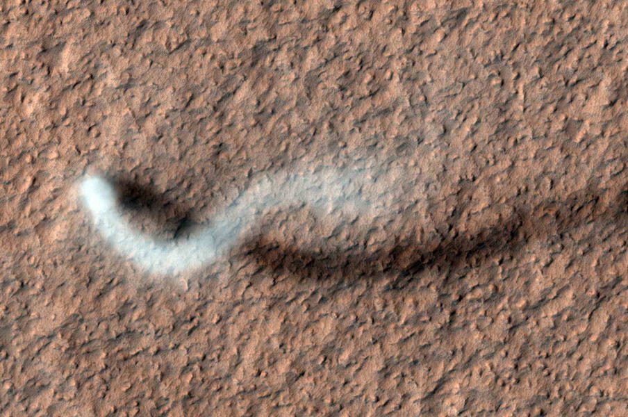
A towering dust devil, casts a serpentine shadow over the Martian surface in this image acquired by the High Resolution Imaging Science Experiment (HiRISE) camera on NASA's Mars Reconnaissance Orbiter. Image credit: NASA/JPL-Caltech/Univ. of Arizona
[/caption]
Mars orbiters, rovers and landers have all captured devils in action before. But this latest shot is a whopper (to speak in the vernacular of the peasantry…*) – not to mention incredibly awesome! The HiRISE camera (High Resolution Imaging Science Experiment) on the Mars Reconnaissance Orbiter has taken an image of an afternoon whirlwind on Mars lofting a twisting column of dust more than 800 meters (about a half a mile) high, with the dust plume about 30 meters or yards in diameter.
HiRISE captured the image on Feb. 16, 2012, in the Amazonis Planitia region of northern Mars. Evidence of many previous whirlwinds, or dust devils, are visible as streaks on the dusty surface shown in the image.
Scientists from JPL said the active dust devil and its delicate arc were produced by a westerly breeze partway up its height.
Just like on Earth, winds on Mars are powered by solar heating. However, Mars is now farthest from the Sun, and even though the exposure to the Sun’s rays is now less, even so, the dust devils are moving dust around on Mars’ surface.
Dust devils occur on Earth as well as on Mars. They are spinning columns of air, made visible by the dust they pull off the ground. Unlike a tornado, a dust devil typically forms on a clear day when the ground is heated by the sun, warming the air just above the ground. As heated air near the surface rises quickly through a small pocket of cooler air above it, the air may begin to rotate, if conditions are just right.
MRO and HiRISE continue to provide insights into the planet’s ancient environments and how processes such as wind, meteorite impacts and seasonal frosts continue to affect the Martian surface today. This mission – operating since 2006 in Mars orbit – has returned more data about Mars than all other orbital and surface missions combined.
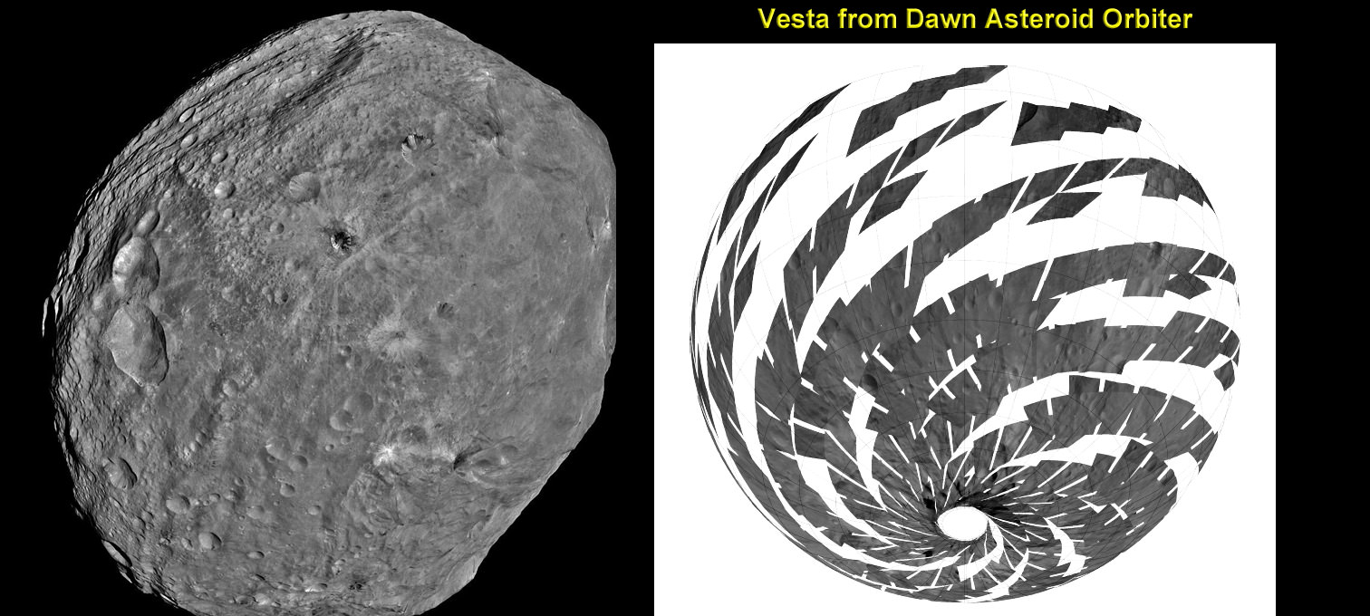
Vesta imaged by NASA’s Dawn Asteroid Orbiter. Dawn is currently at work at the Low Altitude Mapping Orbit (LAMO) acquiring new imagery and spectra of much higher resolution compared to these images acquired at higher altitudes and is also filling in gaps of surface data. The image from Dawn’s Framing Camera, at left, was taken on July 24 at a distance of 3,200 miles soon after achieving orbit around Vesta. The mosaic from Dawn’s Visible and infrared spectrometer (VIR), at right, was acquired from High-altitude mapping orbit (HAMO). Credit: NASA/ JPL-Caltech/ UCLA/ ASI/ INAF/ IAPS. Collage: Ken Kremer
[/caption]
NASA’s Dawn mission is getting a whopping boost in science observing time at the closest orbit around Asteroid Vesta as the probe passes the midway point of its 1 year long survey of the colossal space rock. And the team informs Universe Today that the data so far have surpassed all expectations and they are very excited !
Dawn’s bonus study time amounts to an additional 40 days circling Vesta at the highest resolution altitude for scientific measurements. That translates to a more than 50 percent increase beyond the originally planned length of 70 days at what is dubbed the Low Altitude Mapping Orbit, or LAMO.
“We are truly thrilled to be able to spend more time observing Vesta from low altitude,” Dr. Marc Rayman told Universe Today in an exclusive interview. Rayman is Dawn’s Engineer at NASA’s Jet Propulsion Laboratory (JPL) in Pasadena, Calif.
“It is very exciting indeed to obtain such a close-up look at a world that even a year ago was still just a fuzzy blob.”
The big extension for a once-in-a-lifetime shot at up close science was all enabled owing to the hard work of the international science team in diligently handling any anomalies along the pathway through interplanetary space and since Dawn achieved orbit in July 2011, as well as to the innovative engineering of the spacecraft’s design and its revolutionary ion propulsion system.
“This is a reflection of how well all of our work at Vesta has gone from the beginning of the approach phase in May 2011,” Rayman told me.
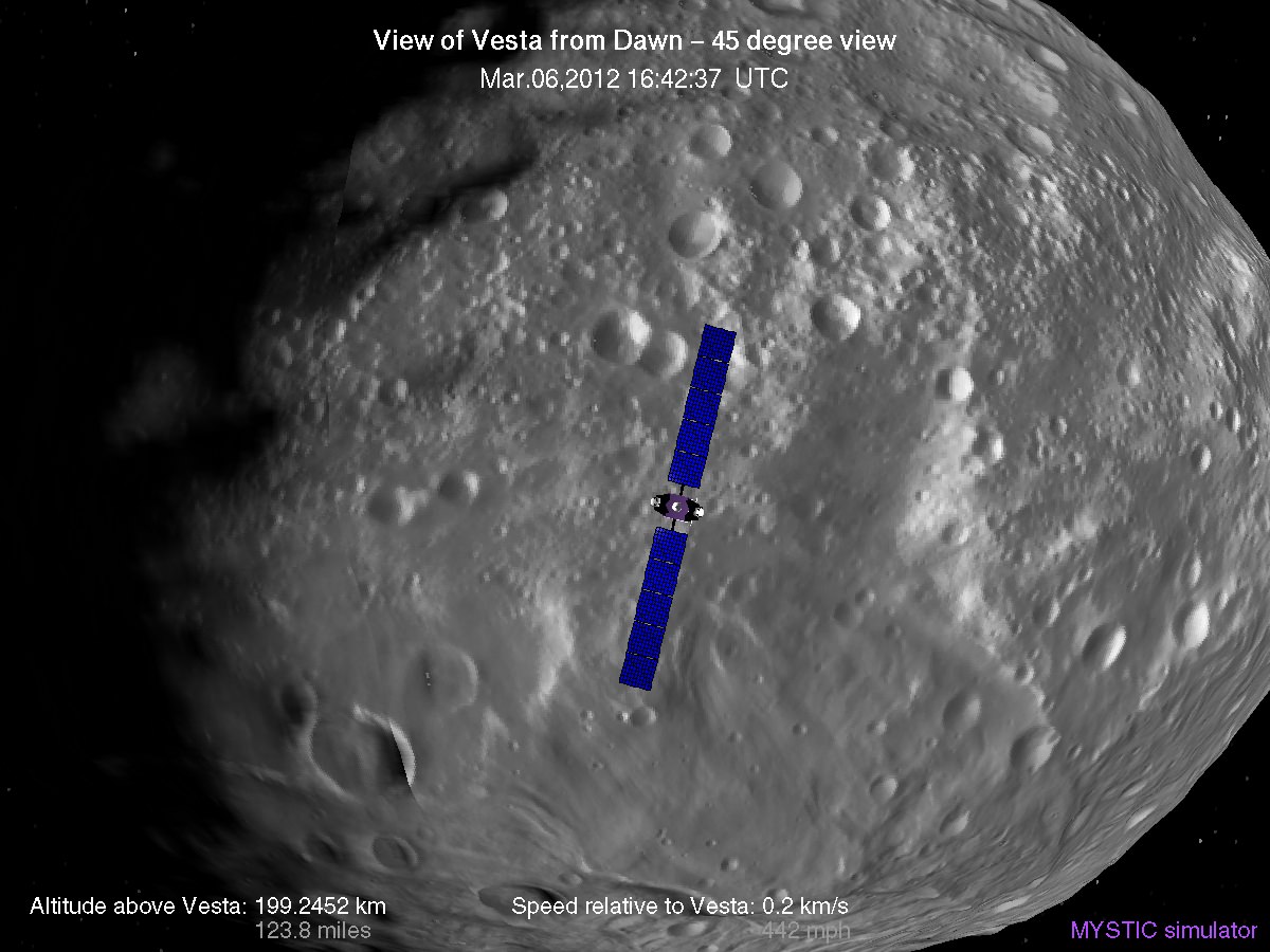
Simulated view of Vesta from Dawn in LAMO, low altitude mapping orbit - March, 6 2012
Credit: Gregory J. Whiffen, JPL
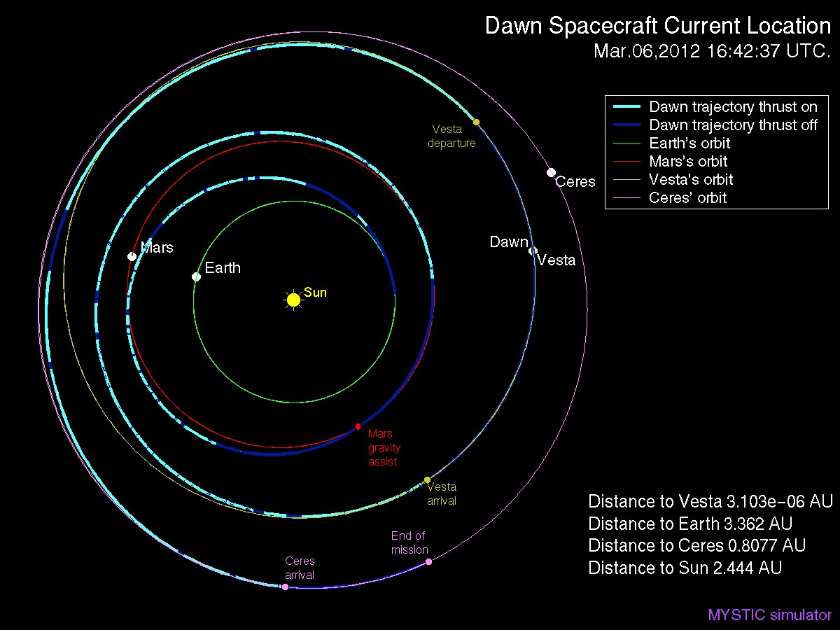
Dawn’s initially projected 10 week long science campaign at LAMO began on Dec. 12, 2011 at an average distance of 210 kilometers (130 miles) from the protoplanet and was expected to conclude on Feb. 20, 2012 under the original timeline. Thereafter it would start spiraling back out to the High Altitude Mapping Orbit, known as HAMO, approximately 680 kilometers above the surface.
“With the additional 40 days it means we are now scheduled to leave LAMO on April 4. That’s when we begin ion thrusting for the transfer to HAMO2,” Rayman stated.
And the observations to date at LAMO have already vastly surpassed all hopes – using all three of the onboard science instruments provided by the US, Germany and Italy.
“Dawn’s productivity certainly is exceeding what we had expected,” exclaimed Rayman.
“We have acquired more than 7500 LAMO pictures from the Framing Camera and more than 1 million LAMO VIR (Visible and Infrared) spectra which afford scientists a much more detailed view of Vesta than had been planned with the survey orbit and the high altitude mapping orbit (HAMO). It would have been really neat just to have acquired even only a few of these close-up observations, but we have a great bounty!”
“Roughly around half of Vesta’s surface has been imaged at LAMO.”
Dawn mosaic of Visible and Infrared spectrometer (VIR) data of Vesta
This mosaic shows the location of the data acquired by VIR (visible and infrared spectrometer) during the HAMO (high-altitude mapping orbit) phase of the Dawn mission from August to October 2011. Dawn is now making the same observations at the now extended LAMO (low-altitude mapping orbit) phase of the Dawn mission from December 2011 to April 2012. VIR can image Vesta in a number of different wavelengths of light, ranging from the visible to the infrared part of the electromagnetic spectrum. This mosaic shows the images taken at a wavelength of 550 nanometers, which is in the visible part of the electromagnetic spectrum. During HAMO VIR obtained more than 4.6 million spectra of Vesta. It is clear from this image that the VIR observations are widely distributed across Vesta, which results in a global view of the spectral properties of Vesta’s surface. This image shows Vesta’s southern hemisphere (lower part of the image) and equatorial regions (upper part of the image). NASA’s Dawn spacecraft obtained these VIR images with its visible and infrared spectrometer in September and October 2011. The distance to the surface of Vesta is around 700 kilometers (435 miles) and the average image resolution is 170 meters per pixel. Credit: NASA/ JPL-Caltech/ UCLA/ ASI/ INAF/ IAPS
The bonus time at LAMO will now be effectively used to help fill in the gaps in surface coverage utilizing all 3 science instruments. Therefore perhaps an additional 20% to 25% extra territory will be imaged at the highest possible resolution. Some of this will surely amount to enlarged new coverage and some will be overlapping with prior terrain, which also has enormous research benefits.
“There is real value even in seeing the same part of the surface multiple times, because the illumination may be different. In addition, it helps for building up stereo,” said Rayman.
Researchers will deduce further critical facts about Vesta’s topography, composition, interior, gravity and geologic features with the supplemental measurements.
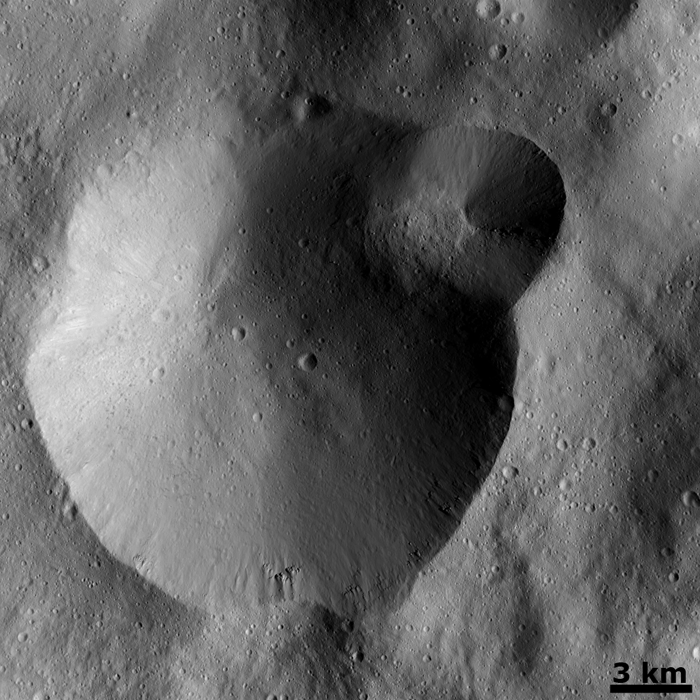
Successive formation of impact craters on Vesta
This Dawn FC (framing camera) image shows two overlapping impact craters and was taken on Dec. 18,2011 during the LAMO (low-altitude mapping orbit) phase of the mission. The large crater is roughly 20 kilometers (12 miles) in diameter and the smaller crater is roughly 6 kilometers (4 miles) in diameter. The rims of the craters are both reasonably fresh but the larger crater must be older because the smaller crater cuts across the larger crater’s rim. As the smaller crater formed it destroyed a part of the rim of the pre-existing, larger crater. The larger crater’s interior is more densely cratered than the smaller crater, which also suggests that is it older. In the bottom of the image there is some material slumping from rim of the larger crater towards its center. This image with its framing camera on Dec. 18, 2011. This image was taken through the camera’s clear filter. The distance to the surface of Vesta is 260 kilometers (162 miles) and the image has a resolution of about 22 meters (82 feet) per pixel. Credit: NASA/ JPL-Caltech/ UCLA/ MPS/ DLR/ IDA
The foremost science goals at LAMO are collection of gamma ray and neutron measurements with the GRaND instrument – which focuses on determining the elemental abundances of Vesta – and collection of information about the structure of the gravitational field. Since GRaND can only operate effectively at low orbit, the extended duration at LAMO takes on further significance.
“Our focus is on acquiring the highest priority science. The pointing of the spacecraft is determined by our primary scientific objectives of collecting GRaND and gravity measurements.”
As Dawn continues orbiting every 4.3 hours around Vesta during LAMO, GRaND is recording measurements of the subatomic particles that emanate from the surface as a result of the continuous bombardment of cosmic rays and reveals the signatures of the elements down to a depth of about 1 meter.
“You can think of GRaND as taking a picture of Vesta but in extremely faint light. That is, the nuclear emissions it detects are extremely weak. So our long time in LAMO is devoted to making a very, very long exposure, albeit in gamma rays and neutrons and not in visible light,” explained Rayman.
Now with the prolonged mission at LAMO the team can gather even more data, amounting to thousands and thousands more pictures, hundreds of thousands of more VIR spectra and ultra long exposures by GRaND.
“HAMO investigations have already produced global coverage of Vesta’s gravity field,” said Sami Asmar, a Dawn co-investigator from JPL. Extended investigations at LAMO will likewise vastly improve the results from the gravity experiment.
Dawn Spacecraft Current Location and Trajectory - March, 6 2012. Credit: Gregory J. Whiffen, JPL
“We always carried 40 days of “margin,” said Rayman, “but no one who was knowledgeable about the myriad challenges of exploring this uncharted world expected we would be able to accomplish all the complicated activities before LAMO without needing to consume some of that margin. So although we recognized that we might get to spend some additional time in LAMO, we certainly did not anticipate it would be so much.”
“As it turned out, although we did have surprises the operations team managed to recover from all of them without using any of those 40 days.”
“This is a wonderful bonus for science,” Rayman concluded.
“We remain on schedule to depart Vesta in July 2012, as planned for the past several years.”
Dawn’s next target is Ceres, the largest asteroid in the main Asteroid Belt between Mars and Jupiter
Artist rendition of NASA’s Mars InSight (Interior exploration using Seismic Investigations, Geodesy and Heat Transport) Lander. InSight is based on the proven Phoenix Mars spacecraft and lander design with state-of-the-art avionics from the Mars Reconnaissance Orbiter (MRO) and Gravity Recovery and Interior Laboratory (GRAIL) missions. Credit: JPL/NASA
[/caption]
A Phoenix-like lander that would mine the deepest hole yet into Mars– to a depth of 5 meters – and unveil the nature of the mysterious deep interior and central core of the Red Planet is under consideration by NASA for a 2016 launch and sports a nifty new name – InSight.
The stationary “InSight” lander would be an international science mission and a near duplicate of NASA’s proven Phoenix spacecraft, Bruce Banerdt told Universe Today. Banerdt is the Principal Investigator of the proposed InSight mission.
“InSight is essentially built from scratch, but nearly build-to-print from the Phoenix design,” Banerdt, of NASA’s Jet Propulsion Laboratory (JPL) in Pasadena , Calif, told me. The team can keep costs down by re-using the blueprints pioneered by Phoenix instead of creating an entirely new spacecraft.
“The robotic arm is similar (but not identical) to the Phoenix arm.”
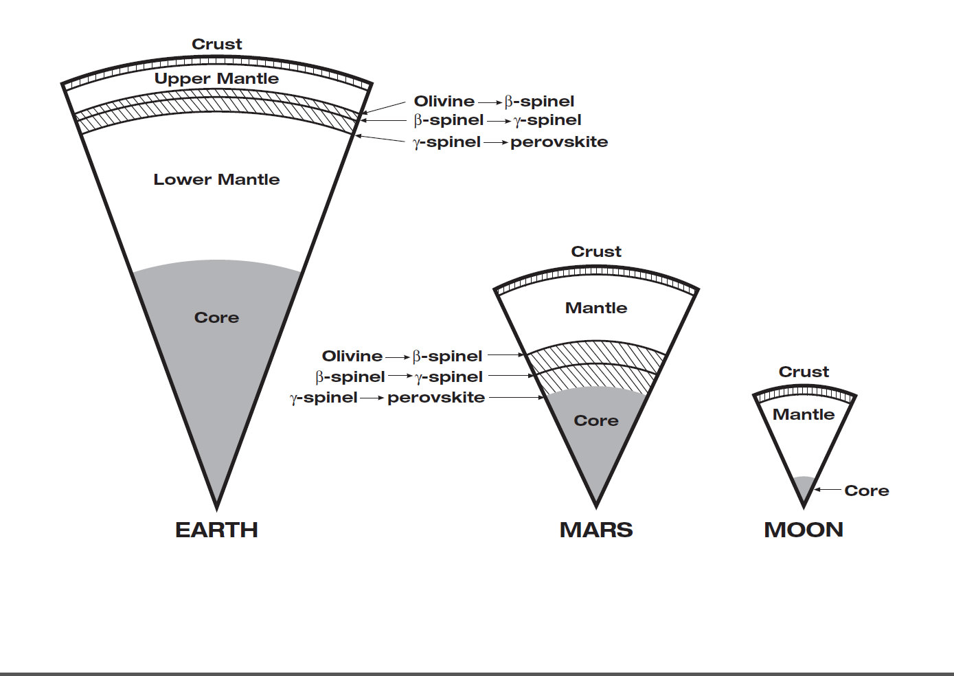
Mars Interior
Insight’s goal is to investigate and deduce the nature of the interior of the Red Planet. Credit: JPL/NASA
However, the landing site and science goals for InSight are quite different from Phoenix.
InSight will have an entirely new suite of three science instruments, including two from Europe, designed to peer to the center of Mars and detect the fingerprints of the processes by which the terrestrial planets formed. It will determine if there is any seismic activity, the amount of heat flow from the interior, the size of Mars core and whether the core is liquid or solid.
NASA’s twin GRAIL lunar gravity probes are set to begin their own investigation into the interior and core of Earth’s Moon in early March 2012, and several science team members are common to GRAIL and InSight.
“The seismometer (SEIS, stands for Seismic Experiment for Interior Structure) is from France (built by CNES and IPGP) and the heat flow probe (HP3, stands for Heat flow and Physical Properties Probe) is from Germany (built by DLR),” Banerdt explained.
Phoenix successfully landed in the frigid northern polar regions of Mars in 2008 in search of potential habitats for life and quickly discovered water ice and salty soils that could be favorable for the genesis and support of extraterrestrial life.
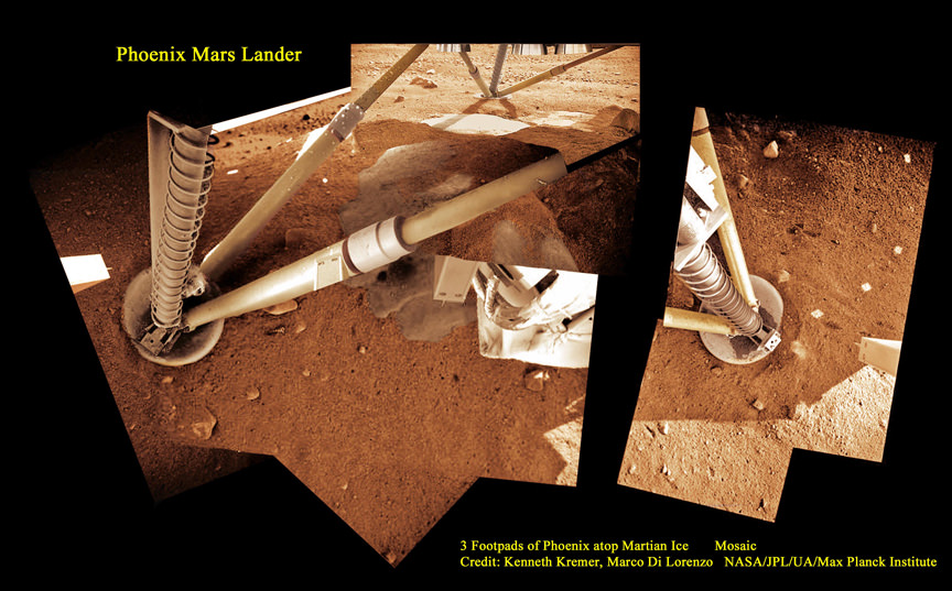
3 Footpads of Phoenix Mars Lander atop Martian Ice
Phoenix thrusters blasted away Martian soil and exposed water ice. Proposed Mars InSight mission will build a new Phoenix-like lander from scratch to peer deep into the Red Planet and investigate the nature and size of the mysterious Martian core. Credit: Kenneth Kremer, Marco Di Lorenzo, Phoenix Mission, NASA/JPL/UA/Max Planck Institute
InSight will intentionally land in a far warmer and sunnier location nearer the moderate climate of the equator to enable a projected lifetime of 2 years (or 1 Mars year) vs. the 5 months survival of Phoenix extremely harsh arctic touchdown zone.
“Our planned landing site is in Elysium Planitia,” Banerdt told me. “It was chosen for optimizing engineering safety margins for landing and power.”
The more equatorial landing site affords far more sun for the life giving solar arrays to power the instruments and electronics.
“We have global objectives and can do our science anywhere on the planet.”
Elysium Planitia is not too far from the landing sites of the Spirit and Curiosity rovers. The Elysium Mons volcano is also in the general area, but it’s a long way from precise site selection.
InSight is a geophysical lander targeted to delve deep beneath the surface into the Martian interior, check its “vital signs”; like “pulse” though seismology, “temperature”, though a heat flow probe, and “reflexes”, through precision tracking.
The purpose is to answer one of science’s most fundamental questions: How were the planets created?
InSight will accomplish much of its science investigations through experiments sitting directly in contact with the Martian surface. The robotic arm will pluck two of the instruments from the lander deck and place them onto Mars.
“The arm will pick the SEIS seismometer and HP3 heat flow probe off the deck and place each on the ground next to the lander. The arm doesn’t have a drill, but the heat flow probe itself will burrow down as deep as 5 meters,” Banerdt elaborated.
The third experiment named RISE (Rotation and Interior Structure Experiment) is to be provided by JPL and will use the spacecraft communication system to provide precise measurements of Mars planetary rotation and elucidate clues to its interior structure and composition.
Right now on Mars, NASA’s Opportunity rover is conducting a Doppler radio tracking experiment similar to what is planned for RISE, but InSight will have a big advantage according to Banerdt.
“The RISE experiment will be very similar to what we are doing right now on Opportunity, but will be able to do much better, said Banerdt. “The differences are that we will get more tracking every week (Opportunity is power-limited during the winter months; that’s why she is currently stationary!) and will make measurements for an entire Mars year – we will likely only get a handful of months from Opportunity.”
Insight will also be equipped with 2 cameras and make some weather measurements.
“We have a camera on the arm and one fixed to the deck, both primarily to support placing the instruments on the surface, although they will be able to scan the landscape around the spacecraft. Both are Black & White,” Banerdt told me.
“We will measure pressure, temperature and wind, mostly to support noise analysis on the seismic data, but will also supply information on the weather.”
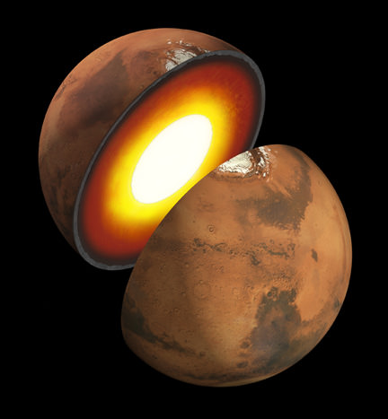
Mars has the same basic internal structure as the Earth and other terrestrial (rocky) planets. It is large enough to have pressures equivalent to those throughout the Earth's upper mantle, and it has a core with a similar fraction of its mass. In contrast, the pressure even near the center of the Moon barely reach that just below the Earth's crust and it has a tiny, almost negligible core. The size of Mars indicates that it must have undergone many of the same separation and crystallization processes that formed the Earth's crust and core during early planetary formation. Credit: JPL/NASA
InSight is one of three missions vying to be selected for flight in NASA’s Discovery Program, a series of low cost NASA missions to understand the solar system by exploring planets, moons, and small bodies such as comets and asteroids. All three mission teams are required to submit concept study reports to NASA on March 19.
Banerdt’s team is working hard to finalize the concept study report.
“It describes the mission design as we have refined it over the past 9 months since the NASA Step-1 selection.”
So there is no guarantee that InSight will fly. Because of severe budget cuts to NASA’s Planetary Science Division, NASA had to cancel its scheduled participation in two other Mars missions dubbed ExoMars and jointed planned with ESA, the European Space Agency, for launch in 2016 and 2018.
This image provided by NASA shows a scraped area on Mars known as "Snow White," photographed on July 8. Two samples from Snow White were delivered to the Phoenix Mars Lander's wet-chemistry lab, and tests turned up evidence of perchlorate. Credit: NASA/JPL/University of Arizona
[/caption]
It happens every summer in humid air: the salt in your salt shaker clumps together as the salt draws in the water from the air. Researchers have found this happens even in the frigid but dry McMurdo Dry Valley in Antarctica, a cold, polar desert. The sandy, salty soils there are frequently dotted with moist patches in the spring despite a lack of snowmelt and no possibility of rain. What was discovered is that the salty soils in the region actually suck moisture out of the atmosphere. Salty soils were found on Mars’ polar region by the Phoenix lander, so could the same thing be happening on the Red Planet, creating a salt brine within Mars’ soil? And if so what are the implications for life forming there?
Joseph Levy, a post-doctoral researcher from Oregon State University said it takes a combination of the right kinds of salts and sufficient humidity to make the process work. But those ingredients are present on Mars.
“If you have sodium chloride, or table salt, you may need a day with 75 percent humidity to make it work,” he added. “But if you have calcium chloride, even on a frigid day, you only need a humidity level above 35 percent to trigger the response.”
The soils in Antarctica have salt from sea spray and from ancient fjords that flooded the region. With enough humidity, those salty soils suck the water right out of the air, forming a brine, Levy said, that will keep collecting water vapor until it equalizes with the atmosphere.
Levy and his colleagues, from Portland State University and Ohio State University, found that the wet soils created by this phenomenon were 3-5 times more water-rich than surrounding soils – and they were also full of organic matter, including microbes, which they said could enhance the potential for life on Mars. The elevated salt content also depresses the freezing temperature of the groundwater, which continues to draw moisture out of the air when other wet areas in the valleys begin to freeze in the winter.
Though Mars, in general, has lower humidity than most places on Earth, studies have shown that it is sufficient to reach the thresholds that Levy and his colleagues have documented in Antarctica.
The parallels of what was found by the Mars Phoenix team is striking. The salty perchlorates found on Mars by the Phoenix lander also strongly attracts water and makes up a few tenths of a percent of the composition in all three soil samples analyzed by Phoenix’s wet chemistry laboratory. Principal investigator of the Phoenix mission, Peter Smith from the University of Arizona, Tucson, said the perchlorates could pull humidity from the Martian air.
A paper about Phoenix water studies, led by Smith, cites clues supporting an interpretation that the soil has had films of liquid water in the recent past. The evidence for water and potential nutrients “implies that this region could have previously met the criteria for habitability” during portions of continuing climate cycles.
At higher concentrations, it might combine with water as a brine that stays liquid at Martian surface temperatures. Some microbes on Earth use perchlorate as food, and future human explorers on Mars might find it useful as rocket fuel or for generating oxygen.
Levy and his team discovered the mysterious patches of wet soil in Antarctica, and then explored the causes. Through soil excavations and other studies, they eliminated the possibility of groundwater, snow melt, and glacial runoff. Then they began investigating the salty properties of the soil, and discovered that the McMurdo Dry Valleys weather stations had reported several days of high humidity earlier in the spring, leading them to their discovery of the vapor transfer.
“It seems kind of odd, but it really works,” Levy said. “Before one of our trips, I put a bowl of the dried, salty soil and a jar of water into a sealed Tupperware container and left it on my shelf. When I came back, the water had transferred from the jar to the salt and created brine.
“I knew it would work,” he added with a laugh, “but somehow it still surprised me that it did.”
The salty soils also are present on the Red Planet, which makes the upcoming landing of the Mars Science Laboratory this summer even more tantalizing.
Evidence of the salty nature of the McMurdo Dry Valleys is everywhere, Levy said. Salts are found in the soils, along seasonal streams, and even under glaciers. Don Juan Pond, the saltiest body of water on Earth, is found in Wright Valley, the valley adjacent to the wet patch study area.
“The conditions for creating this new water source into the permafrost are perfect,” Levy said, “but this isn’t the only place where this could or does happen. It takes an arid region to create the salty soils, and enough humidity to make the transference work, but the rest of it is just physics and chemistry.”
The study by Levy and his team was published online this week in the journal Geophysical Research Letters.
Changing seasons in Mars’ northern hemisphere brings a change in the weather, and the clouds have rolled in to cover part of the polar surface in this intriguing image from the Mars Odyssey spacecraft.
Mars Odyssey’s THEMIS visual imager (VIS) captured this image on Jan. 24, 2012, as it passed over the Red Planet’s northern pole during one of its 2-hour-long orbits.
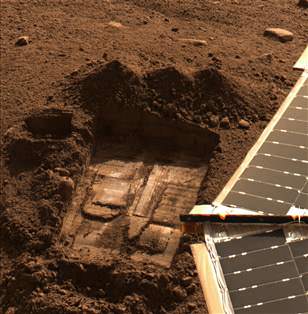
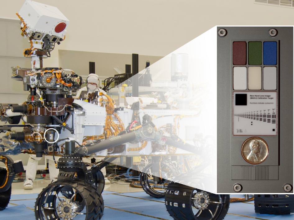
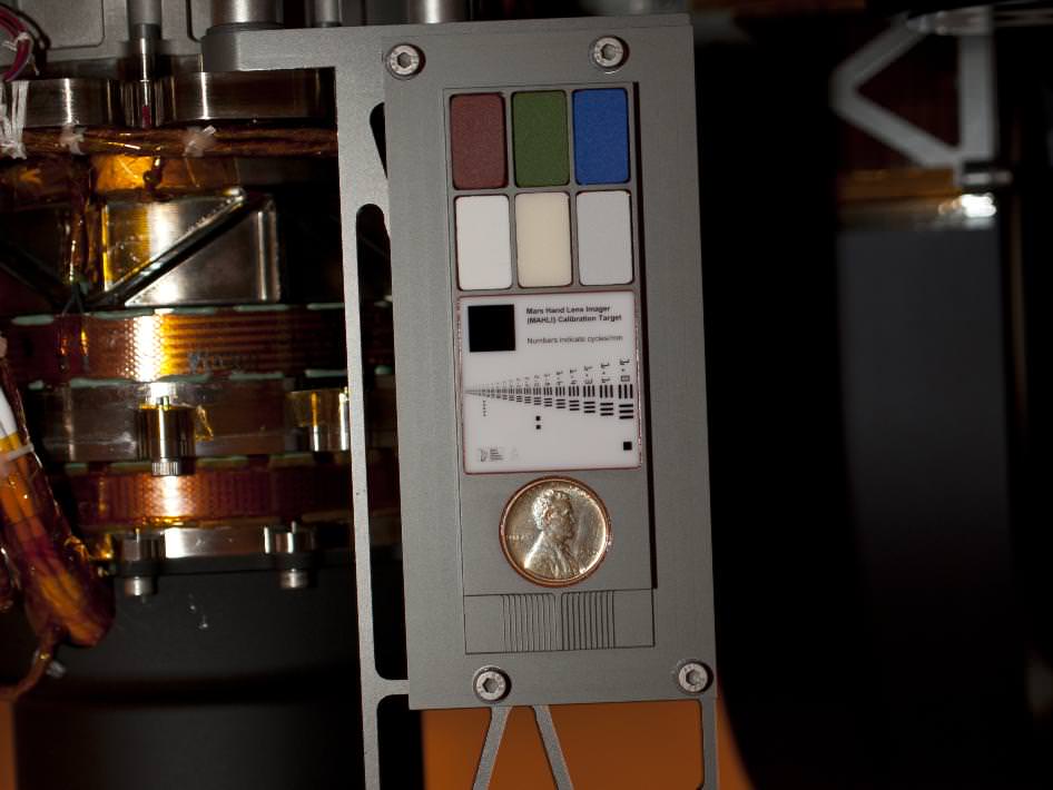
NASA's Mars rover Curiosity carries a Lincoln Penny on the calibration target to be used by a camera at the end of the robotic arm. The calibration target for the Mars Hand Lens Imager (MAHLI) camera is attached to a shoulder joint of the arm. Inset shows the location of the calibration target. Credit: NASA/JPL-Caltech
[/caption]
NASA’s huge Curiosity Mars Science Lab (MSL) rover is carrying a vintage Lincoln penny along for the long interplanetary journey to Mars – and it’s not to open the first Martian savings account.
Scientists will use the century old Lincoln penny – minted back in 1909 – as a modern age calibration target for one of Curiosity’s five powerful science cameras attached to the end of the hefty, 7 foot (2.1 meter) long robotic arm.
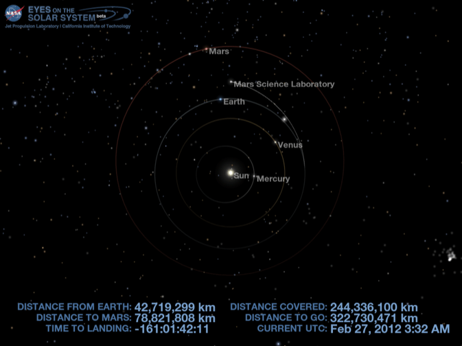
The car sized rover is on course to touchdown at the foothills of a towering and layered mountain inside Gale Crater in just 161 days on Aug. 6, 2012.
So far Curiosity has traveled 244 million kilometers since blasting off on Nov. 26, 2011 from Florida and has another 322 million kilometers to go to the Red Planet.
The copper penny is bundled to a shoulder joint on the rovers arm along with the other elements of the calibration target, including color chips, a metric standardized bar graphic, and a stair-step pattern for depth calibration.
The whole target is about the size of a smart phone and looks a lot like an eye vision chart in an ophthalmologist’s office. And it serves a similar purpose, which will be to check the performance of Curiosity eyes – specifically the Mars Hand Lens Imager (MAHLI) camera located at the terminus of the robotic arm.
Curiosity’s Calibration Target
Two instruments at the end of the robotic arm on NASA's Mars rover Curiosity will use calibration targets attached to a shoulder joint of the arm. Credit: NASA/JPL-Caltech
MAHLI will conduct close-up inspections of Martian rocks and soil. It can show tiny details, finer than a human hair.
The term “hand lens” in MAHLI’s name refers to the standard practice by field geologists’ of carrying a hand lens during expeditions for close up, magnified inspection of rocks they find along the way. So it’s also critical to pack various means of calibration so that researchers can interpret their results and put them into proper perspective.
MAHLI can also focus on targets over a wide range of distances near and far, from about a finger’s-width away out to the Red Planets horizon, which in this case means the mountains and rim of the breathtaking Gale Crater landing site.
“When a geologist takes pictures of rock outcrops she is studying, she wants an object of known scale in the photographs,” said MAHLI Principal Investigator Ken Edgett, of Malin Space Science Systems, San Diego, which supplied the camera to NASA.
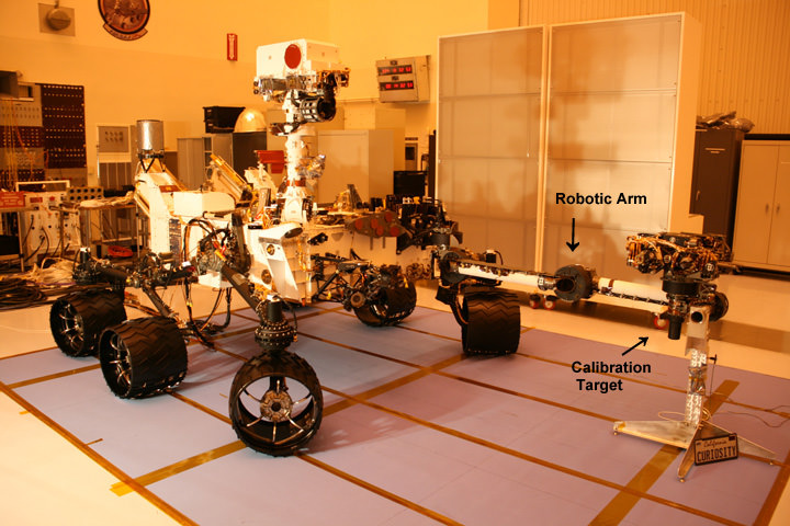
Curiosity Mars Science Laboratory Rover - inside the Cleanroom at KSC
Curiosity with robotic arm extended. Calibration target is located at a shoulder joint on the arm. Photo taken just before encapsulation for 8 month long interplanetary Martian Journey and touchdown inside Gale Crater. Credit: Ken Kremer
The target features a collection of marked black bars in a wide range of labeled sizes to correlate calibration images to each image taken by Curiosity.
“If it is a whole cliff face, she’ll ask a person to stand in the shot. If it is a view from a meter or so away, she might use a rock hammer. If it is a close-up, as the MAHLI can take, she might pull something small out of her pocket. Like a penny.”
Edgett donated the special Lincoln penny with funds from his own pocket. The 1909 “VDB” cent stems from the very first year that Lincoln pennies were minted and also marks the centennial of President Abraham Lincoln’s birth. The VDB initials of the coin’s designer – Victor David Brenner — are on the reverse side. In mint condition the 1909 Lincoln VDB copper penny has a value of about $20.
The Lincoln penny in this photograph is part of a camera calibration target attached to NASA's Mars rover Curiosity. Credit: NASA/JPL-Caltech
“The penny is on the MAHLI calibration target as a tip of the hat to geologists’ informal practice of placing a coin or other object of known scale in their photographs. A more formal practice is to use an object with scale marked in millimeters, centimeters or meters,” Edgett said. “Of course, this penny can’t be moved around and placed in MAHLI images; it stays affixed to the rover.”
“Everyone in the United States can recognize the penny and immediately know how big it is, and can compare that with the rover hardware and Mars materials in the same image,” Edgett said.
“The public can watch for changes in the penny over the long term on Mars. Will it change color? Will it corrode? Will it get pitted by windblown sand?”
MAHLI’s calibration target also features a display of six patches of pigmented silicone to assist in interpreting color and brightness in the images. Five of them are leftovers from Spirit and Opportunity. The sixth has a fluorescent pigment that glows red when exposed to ultraviolet light, allows checking of an ultraviolet light source on MAHLI. The fluorescent material was donated to the MAHLI team by Spectra Systems, Inc., Providence, R.I.
Three-dimensional calibration of the MSL images will be done using the penny and a stair-stepped area at the bottom of the target.
“The importance of calibration is to allow data acquired on Mars to be compared reliably to data acquired on Earth,” said Mars Science Laboratory Project Scientist John Grotzinger, of the California Institute of Technology, Pasadena.
Curiosity is a 1 ton (900 kg) behemoth. She measures 3 meters (10 ft) in length and is nearly twice the size and five times as heavy as Spirit and Opportunity, NASA’s prior set of twin Martian robots. The science payload is 15 times heavier than the twin robots.
Curiosity is packed to the gills with 10 state of the art science instruments that are seeking the signs of life in the form of organic molecules – the carbon based building blocks of life as we know it.
NASA could only afford to build one rover this time.
Curiosity MSL location on 27 Feb 2012. Credit: NASA
Curiosity will be NASA’s last Mars rover since the 4th generation ExoMars rover due to liftoff in 2018 was just cancelled by the Obama Administration as part of a deep slash to NASA’s Planetary Science budget.
En route to the Red Planet, Mars rover Curiosity has experienced the strongest solar radiation storm since 2005. No need to be alarmed: Researchers say it’s all part of Curiosity’s job as a ‘stunt double’ for human astronauts.
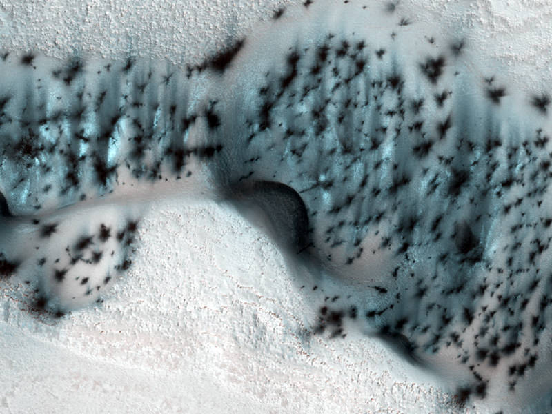
These barchan (crescent-shaped) sand dunes are found within the North Polar region of Mars. Credit: NASA/JPL/University of Arizona
[/caption]
Say the word “dunes” and the image that likely comes to mind is the sort of features you’d see in the Sahara Desert; huge mounds of carmel-colored shifting sand. But on Mars, dunes take on an entirely different connotation, and with the orbital eyes of the HiRISE camera on the Mars Reconnaissance Orbiter, we’ve seen some pretty bizarre-looking dunes. Take the image above for example, a newly released photo of well-speckled dunes in Mars’ north polar region. In this image, taken during the northern spring season, the dunes and ground are still covered in seasonal frost. “The speckled appearance is due to the warming of the area — as the carbon dioxide frost and ice on the dunes warms, small areas warm and sublimate (turn from solid to gas) faster, creating small jets that expose/deposit dark sand and dust onto the surface,” writes Serina Diniega on the HiRISE website. “Notice that there are no spots on the ground between the dunes — that is because the ground stays more uniformly cold, unlike the darker dune sand.”
See below for more weird dunes on Mars.
Dunes in Aonia Terra on Mars. Credit: NASA/JPL/University of Arizona
These dunes look as through someone has thrown a rippled blue-toned cloth across Mars’ surface. HiRISE is monitoring these dunes in Aonia Terra for changes such as gullies, which form over the winter from the action of carbon dioxide frost. This image was taken on January 18, 2012 here on Earth, but the season in on Mars where this was taken was late fall in the Southern hemisphere. “Frost is just starting to accumulate here, and is concentrated on pole-facing slopes and in the troughs between the meter-scale ripples,” wrote HiRISE Principal Investigator Alfred McEwen.
Dunes in Russell Crater Dunes on Mars. Credit: NASA/JPL/University of ArizonaPink dunes with black polka-dot speckles. Credit: NASA/JPL/University of ArizonaA wide area of dunes in Terra Cimmeria look as if they are being viewed under water. Credit: NASA/JPL/University of ArizonaFans and polygons on Dunes. Credit: NASA/JPL/University of ArizonaDark sand dunes at high Northern latitudes on Mars are covered seasonally by a layer of condensed carbon dioxide (dry ice), visible in this image. Credit: NASA/JPL/University of Arizona
Chocolate dunes? Credit: NASA/JPL/University of Arizona
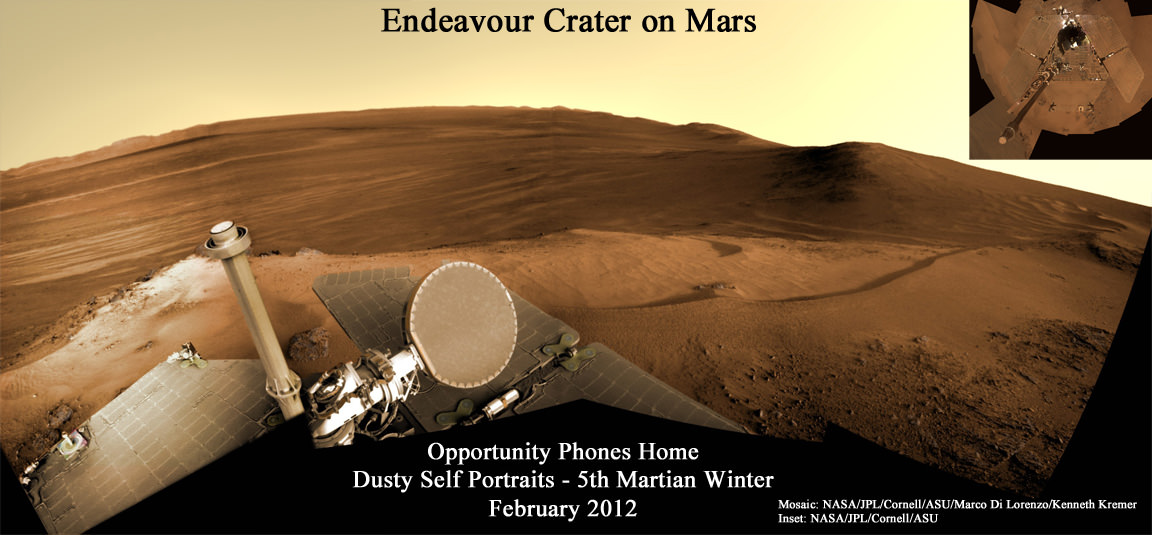
Mosaic: NASA/JPL/Cornell/ASU/Marco Di Lorenzo/Kenneth Kremer
[/caption]
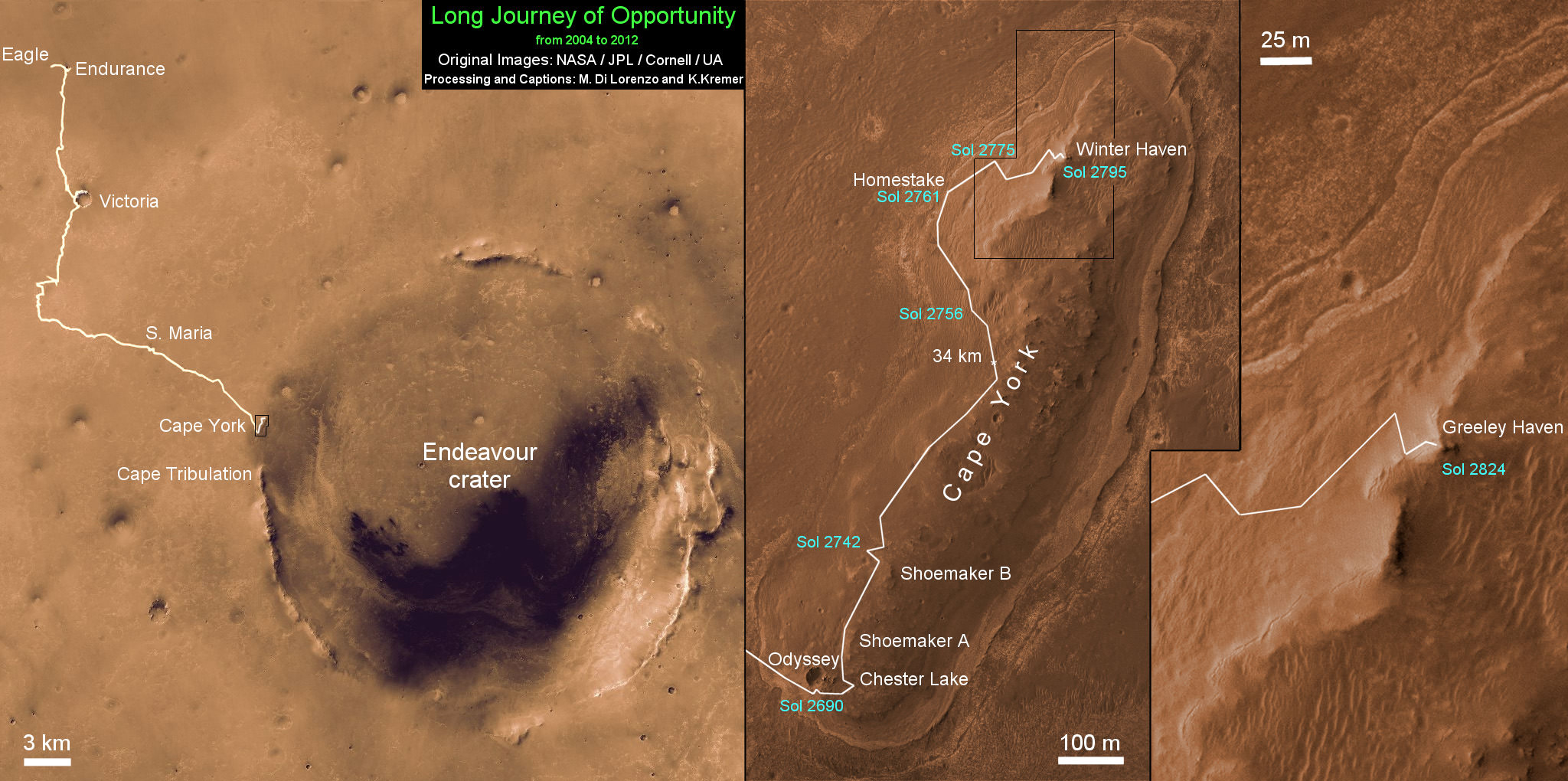
Opportunity, the Princess of Martian Robots, phoned home dusty new self portraits – above and below – of her beautiful bod basking in the utterly frigid sunshine during her 5th winter on the Red Planet whilst overlooking a humongous crater offering bountiful science.
NASA’s endearing robot is simultaneously carrying out an ambitious array of ground breaking science experiments this winter – providing insight into the mysterious nature of the Martian core – while sitting stationary until the energy augmenting rays of the springtime Sun shower down on Mars from the heavens above.
Opportunity’s current winter worksite is located at the rim of the vast crater named Endeavour, some 14 miles (22 kilometers) in diameter. The robot will remain parked for the winter on a slope at the north end of the crater rim segment called Cape York with an approximate 15-degree northerly tilt towards the life-giving sun to maximize solar energy production. The park-site is at an outcrop dubbed “Greeley Haven”, named in honor of Ronald Greeley, a beloved and recently deceased science team member.
The power killing dust buildup is readily apparent on the solar arrays and High Gain Antenna pictured in the new panoramic self-portraits of Opportunity’s wing-like deck. The red Martian dust also functions as a rather effective camouflage agent, sometimes blending the rover to near invisibility with the surface.
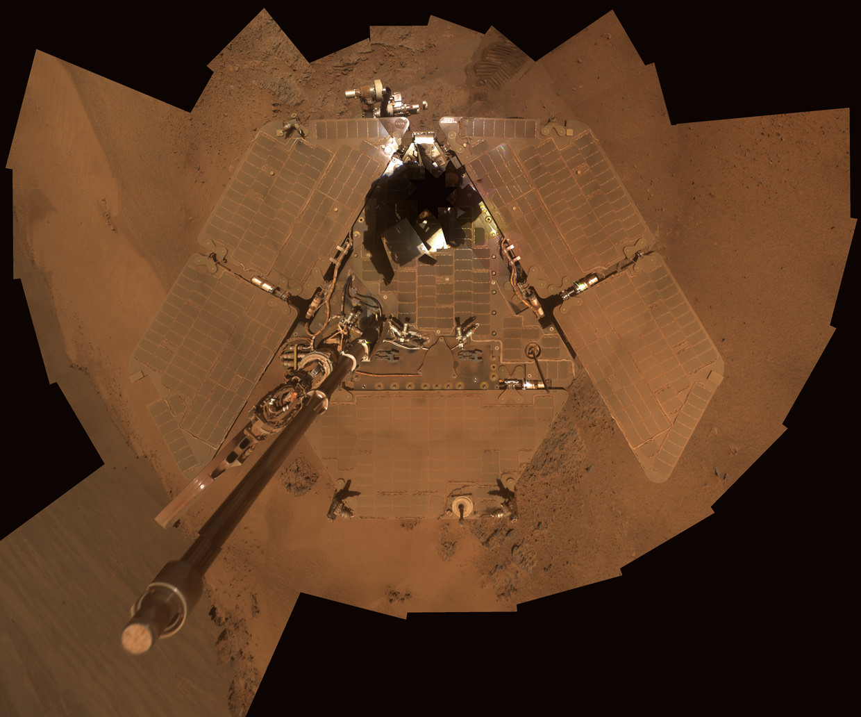
Dusty Mars Rover's Self-Portrait- Dec 2011
NASA's Mars Exploration Rover Opportunity shows dust accumulation on the rover's solar panels as the mission approached its fifth Martian winter at the rim of Endeavour Crater. Opportunity is located on the north-facing slope of a site called "Greeley Haven." This is a mosaic of images taken by Opportunity's panoramic camera (Pancam) during the 2,811th to 2,814th Martian days, or sols, of the rover's mission (Dec. 21 to Dec. 24, 2011). Credit: NASA/JPL-Caltech/Cornell/Arizona State Univ.
Indeed because Opportunity is covered with a thicker film of dust compared to her prior four Martian winters, the rover team was forced to employ the same “tilting” strategy they successfully used to keep her twin sister Spirit alive during her trio of Antarctic-like winters. This is the first winter that Opportunity did not have sufficient power to continue roving across the surface.
Since Opportunity is located just south of the Martian equator, the daylight hours for solar power generation are growing shorter until the southern Mars winter solstice occurs on March 30, 2012. As of mid- February 2012, the latest measure of solar array energy production was 274 watt-hours, compared to about 900 watt-hours at the start of the mission. See Solar Power energy graph below.
Power generation from the solar arrays has fluctuated up and down throughout Opportunity’s lifetime depending on when the completely unpredictable and fortuitous Martian wind storms chance by and miraculously clean the arrays of the rusty red dust.
Opportunity Rover Self-Portrait From 2007
Opportunity used its panoramic camera (Pancam) during the mission's sols 1282 and 1284 (Sept. 2 and Sept. 4, 2007) to take the images combined into this mosaic view of the rover. The downward-looking view omits the mast on which the camera is mounted.The deck panorama is presented in approximate true color, the camera team's best estimate of what the scene would look like if humans were there and able to see it with their own eyes.Credit: NASA/JPL-Caltech/Cornell
The rover science team is ingeniously using the lack of movement to their advantage and Opportunity is still vigorously hard at work doing breakthrough research each and every day.
From her stationary position, Opportunity is conducting her first ever radio science Doppler tracking measurements to support geo-dynamic investigations and to elucidate the unknown structure of the Martian interior and core. The team was eager for the long awaited chance to carry out the radio tracking experiment with the High Gain Antenna (HGA) and determine if Mars core is liquid or solid. Months of data collection are required while the rover stays stationary.
“This winter science campaign will feature two way radio tracking with Earth to determine the Martian spin axis dynamics – thus the interior structure, a long-neglected aspect of Mars,” Ray Arvidson told Universe Today. Arvidson, of Washington University in St. Louis, is the deputy rover Principal Investigator.
Opportunity has nearly finished snapping the 13 filter, 360 degree stereo Greeley” panorama. The rover deployed the robotic arm onto the surface of the “Amboy” outcrop to collect multi-sol integrations with the Mössbauer Spectrometer and the largest ever mosaic campaign using the Microscopic Imager.
“We’ll do good science while we’re at Greeley Haven. But as soon as we catch a wind gust or the seasons change, we’ll be on our way again,” Steve Squyres told Universe Today. Squyres, of Cornell University is the rover Science Principal Investigator
“The Martian southern winter solstice occurs at the end of March. A few months after that date we will drive her off the outcrop and further explore Cape York,” Arvidson told me
The team will drive Opportunity in search of further evidence of the gypsum mineral veins like “Homestake” – indicative of ancient water flow – previously discovered at Cape York. Thereafter they’ll rove further south to investigate deposits of phyllosilicates, the clay minerals which stem from an earlier epoch when liquid water flowed on Mars eons ago and perhaps may have been more favorable to sustaining life.
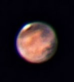
Graph shows Opportunity’s Solar power energy generation over the past 1000 Sols, or Martian Days, from Sol 1900 up to February 2012. Credit: NASA/JPL/Marco Di Lorenzo Mars from Earth on Feb 18, 2012 is nearly at opposition (occurs March 3) in this image taken using a Celestron 11 inch telescope in Leesburg, Florida. Astrophotographer Credit: Ernie Rossi
Opportunity is now well into her 9th year exploring hitherto unknown terrain on Mars, far exceeding anyone’s expectation. She landed inside a tiny crater on Jan. 24. 2004 for what was expected to be a mission of merely 90 Martian days, or Sols.
Today is Martian Sol 2873, that’s 32 times beyond the rover designers “warranty” for NASA’s Opportunity rover.
Altogether, Opportunity has journeyed more than 21 miles (34 kilometers) across the Red Planet’s surface, marking the first overland expedition on another Planet. See our route map below.
Opportunity Rover Traverse Map at Meridiani Planum on Mars - 2004 to 2012
Traverse map shows the 8 Year Journey of Opportunity from Eagle Crater landing site on Sol 1- Jan. 24, 2004 - to 5th Winter Haven worksite at Greeley Haven at Endeavour Crater rim in January 2012. Opportunity embarked on a crater tour and discovered bountiful evidence for the flow of liquid water on Mars billions of years ago. Endeavour Crater is 14 miles 22 kilometers) in diameter. Opportunity has driven more than 21 miles (34 km). Credit: NASA/JPL/Cornell/UA/Marco Di Lorenzo/Kenneth Kremer
Meanwhile, NASA’s Curiosity Mars Science Laboratory rover is rocketing through space and on course for a pinpoint touchdown inside the layered terrain of Gale Crater on August 6, 2012. Curiosity is now America’s last planned Mars rover following the cancellation of the joint NASA/ESA ExoMars rover mission in the Obama Administrations newly announced Fiscal 2013 NASA budget.
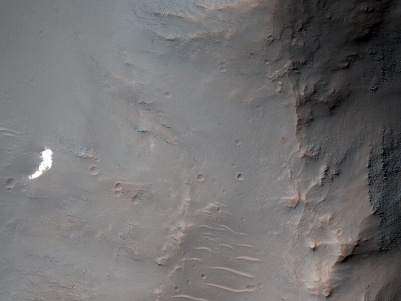
The 'lost' Soviet Mars 6 lander may be somewhere in this image. Credit: NASA/JPL/University of Arizona
[/caption]
Mars could be considered a spacecraft graveyard. The planet is just a hard place to get to – and especially land on — and there are several ‘lost’ spacecraft lying somewhere on Mars’ surface. The Soviet Mars 6 lander arrived at Mars on March 12, 1974. The records detail that the descent module entered the atmosphere and the parachute opened at 09:08:32 UT, and during that time, the craft was collecting and returning data. However, contact with the descent module was lost at 09:11:05 UT, about the time it was expected to reach the surface.
“Because we know that the parachute opened and have some idea where it was headed, we have a chance of locating the hardware on the surface with HiRISE,” said Alfred McEwen, principal investigator for HiRISE, the High Resolution Imaging Science Experiment camera on board the Mars Reconnaissance Orbiter.
And it may be in this image, as it would be in approximately the right region of where Mars 6 was supposed to land. In fact, hopes were raised when an anomalous small bright patch was seen by MRO’s Context Camera (CTX) team, and then a CTX team member suggested this area as a target for HiRISE.
McEwen said that since bright parachutes were the easiest thing to spot on the ground at 5 of the 6 past successful landing sites, but as you can see in this subimage, the bright spot at full HiRISE resolution appears to be just “a patch of relatively bright bedrock, with a pattern of thin lines (fractures) typical of such outcrops.”
But after nearly 38 years, the parachute and hardware may be covered by dust and look much like natural features on Mars.
“We’ll keep trying to find this and other failed landers,” McEwen said, “but there is a lot of surface area to cover on Mars.”