Curiosity’s First 360-Degree Color Panorama

Doesn’t Gale Crater look lovely this time of year? This is the first 360-degree panorama of color images taken by Curiosity’s color Mast Camera. The individual images used in this first panorama may only have been thumbnail-sized, but the effect is no less stunning.

(Click the image to panoramify.)

 The images were acquired on August 9 EDT. Although taken during late afternoon at Gale crater, the individual images still had to be brightened as Mars only receives half the amount of sunlight that Earth does.

Full-size 1200×1200 pixel images will be available at a later date.

The two grey patches in the foreground at left and right are the result of Curiosty’s sky crane rockets blasting the Martian surface. Scientists will be investigating these areas as they expose material that was previously hidden beneath Mars’ red dust.

The base of Gale Crater’s 3.4-mile (5.5 km) high central peak, named Mt. Sharp in honor of planetary science pioneer Robert P. Sharp, can be seen in the distance at center. (Check out an oblique view of a portion of Mt. Sharp acquired by HiRISE camera here.)

You can play with an interactive 360-degree panorama at the NASATech website, put together by John O’Connor, and if you look closely, visible is the full JPL logo on the middle right wheel — in Morse Code!

As always, you can find more news from the MSL mission here.

Image: NASA/JPL-Caltech

Curiosity and the Mojave Desert of Mars – Panorama from Gale Crater

Image Caption: Curiosity and the Mojave Desert of Mars at Gale Crater North Rim, False Color Mosaic. This false color panoramic mosaic shows Curiosity in the foreground looking to the eroded rim of Gale Crater in the background. Visible at left is a portion of the RTG nuclear power source, low gain antenna pointing up, then the deployed High Gain antenna and other components of the rover deck. This mosaic was assembled from the three new full resolution Navcam images returned by Curiosity overnight and snapped on Sol 2 on Aug. 8. Image stitching by Ken Kremer and Marco Di Lorenzo. Topsoil at right foreground has been excavated by the descent landing thrusters to expose what the team believes is bedrock. See black and white version below. Credit: NASA/JPL-Caltech/Ken Kremer/Marco Di Lorenzo

Curiosity lead scientist John Grotzinger calls this place “The Mojave Desert” of Mars– that’s the sweet spot where NASA’s huge new Curiosity rover landed only 3 Sols, or days ago, and looks so “Earth-like”.

See above and below our new 3 frame panoramic mosaic showing Curiosity with a dramatic “Mojave Desert” backdrop – in false color and black and white – assembled from new pictures received overnight at JPL.

With her camera mast erected, Curiosity is beginning to beam back a flood of spectacular images and giving us the first detailed view of her new surroundings from her touchdown point inside Gale Crater on Mars beside a 3.4 mile (5.5 km) high layered mountain nicknamed Mount Sharp.

Overnight, Curiosity sent back many more full frame pictures from her Navcam navigation camera, including exquisite high resolution views of herself with the eroded rim of Gale Crater over her shoulder.

At Wednesday’s briefing, Grotzinger has ecstatic with the initial set of high resolution images showing Gale crater in the distance, saying;

“The thing that really struck the science team about this image, you would really be forgiven for thinking that NASA was trying to pull a fast one on you and we actually put a rover out in the Mojave Desert and took a picture.

“That’s the part of the rim that’s lowest in elevation, facing the northern lowlands of Mars.”

“The thing that’s amazing about this is to a certain extent the first impression you get is how earth-like this seems, looking at that landscape.”

The terrain is strewn with small pebbles that the team hypothesizes may stem from a nearby alluvial fan through which liquid water flowed long ago and is exactly why they chose Gale Crater as Curiosity’s landing site.

“The sedimentary materials, all those materials are derived from erosion of those mountains there, that’s the source region for this material,” Grotzinger said. “It’s really kind of fantastic.”

The first 360 color panorama from the Mastcam cameras are expected soon.

Ken Kremer

Image Caption: Curiosity and the Mojave Desert of Mars at Gale Crater North Rim. This false color panoramic mosaic shows Curiosity in the foreground looking to the eroded rim of Gale Crater in the background. Visible at left is a portion of the RTG nuclear power source, low gain antenna pointing up, then the deployed High Gain antenna and other components of the rover deck. This mosaic was assembled from the three new full resolution Navcam images returned by Curiosity overnight. Processing by Ken Kremer and Marco Di Lorenzo. Topsoil at right foreground has been excavated by the descent landing thrusters to expose what the team believes is bedrock. Credit: NASA/JPL-Caltech/Ken Kremer/Marco Di Lorenzo

Image Caption: Looking to Martian bedrock and Gale Crater North Rim, False Color- This two frame mosaic was assembled from the first two full resolution Navcam images returned by Curiosity on Sol 2 (Aug 8) and enhanced and colorized to bring out further details. Image sticthing and processing by Ken Kremer and Marco Di Lorenzo. Topsoil in the foreground has been excavated by the Sky crane descent landing thrusters to expose what the team believes is bedrock. Credit: NASA/JPL-Caltech/Ken Kremer/Marco Di Lorenzo – www.kenkremer.com

Curiosity raises Mast and snaps 1st Self Portrait and 1st 360 Panorama

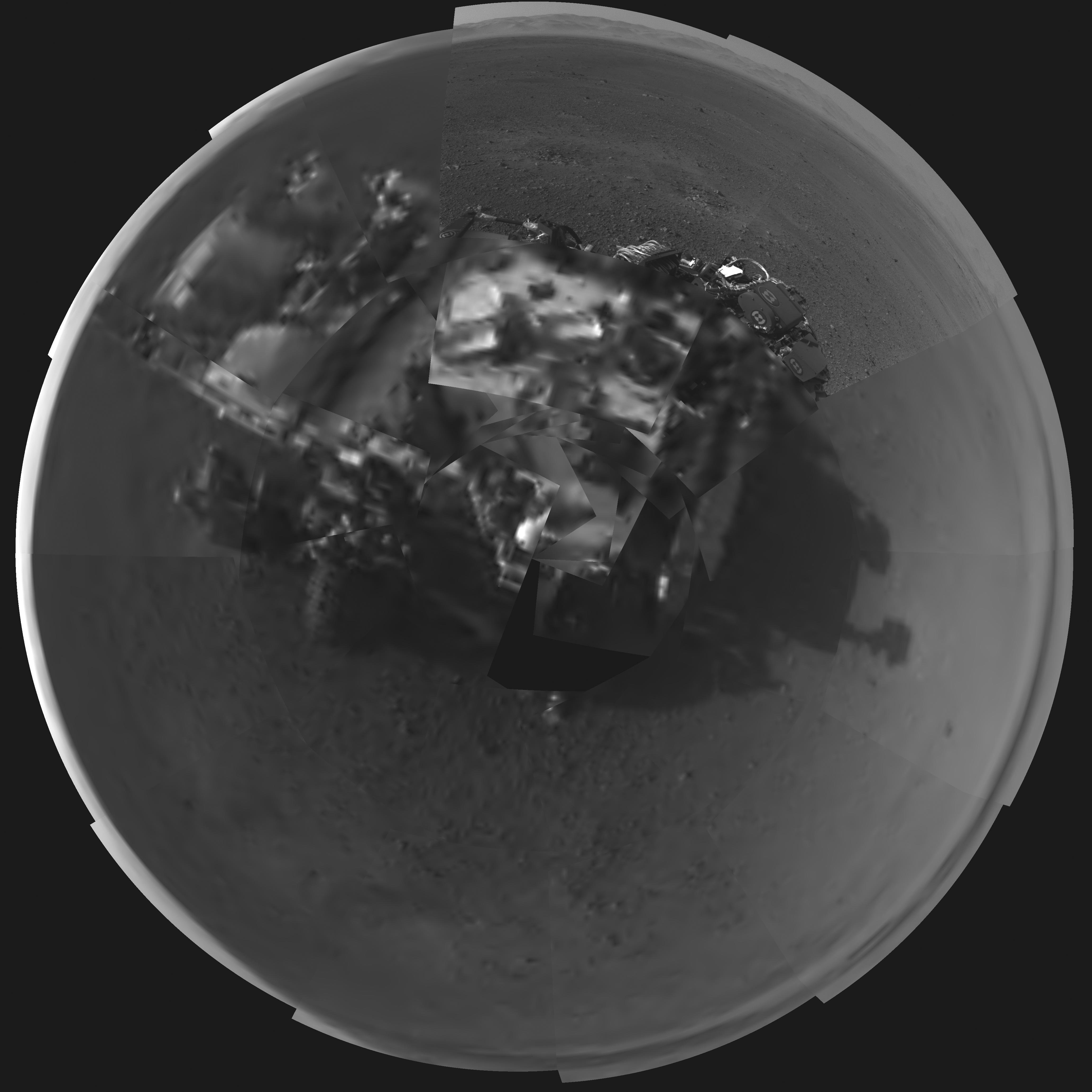
Image Caption: Rover’s Self Portrait -This Picasso-like self portrait of NASA’s Curiosity rover was taken by its Navigation cameras, located on the now-upright mast. The camera snapped pictures 360-degrees around the rover, while pointing down at the rover deck, up and straight ahead. Those images are shown here in a polar projection. Most of the tiles are thumbnails, or small copies of the full-resolution images that have not been sent back to Earth yet. Two of the tiles are full-resolution. Credit: NASA/JPL-Caltech.
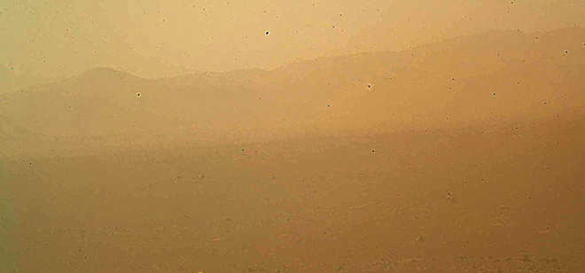
See below the 1st 360 degree panorama from Curiosity and an enhanced Sol 2 mosaic of the full resolution view of the north rim of Gale Crater by this author

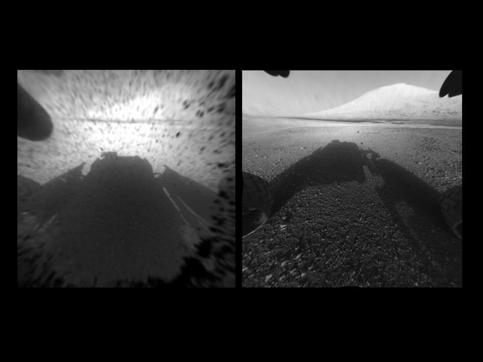
The rover Curiosity continues her marathon run of milestone achievements – snapping her 1st self portrait and 1st 360 degree panorama since touchdown inside Gale Crater barely over 2 sols, or Martian days ago.

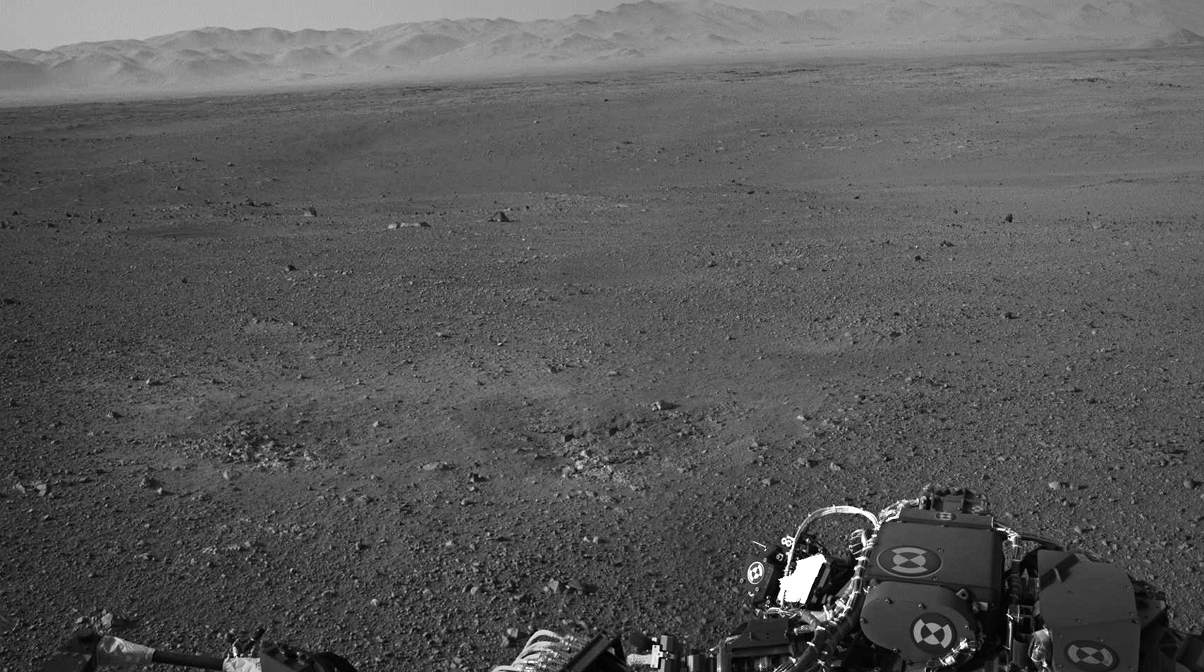
To take all these new images, Curiosity used a new camera, the just-activated higher resolution navigation cameras (Navcam) positioned on the mast. Several of the new images provide the best taste yet of the stupendous vistas coming soon. See our enhanced Sol 2 mosaic below.

The 3.6 foot-tall (1.1 meter) camera mast on the rover deck was just raised and activated earlier today, Wednesday, Aug. 8.

The mast deployment is absolutely crucial to Curiosity’s science mission. It is also loaded with the high resolution MastCam cameras and the ChemCam instrument with the laser rock zapper.

Most of the images Navcam images beamed back today were lower-resolution thumbnails. But 2 high-resolution Navcams from the panorama and the self portrait were also downlinked and provide the clearest view yet of the breathtaking terrain surrounding Curiosity in every direction.

“The full frame navcams show the north rim of Gale Crater,” said Justin Maki, MSL navcam lead, at a briefing today at JPL. “The Navcam’s are identical to the MER Navcam’s.”

The hi res images also show how the descent thruster excavated the topsoil like Phoenix.

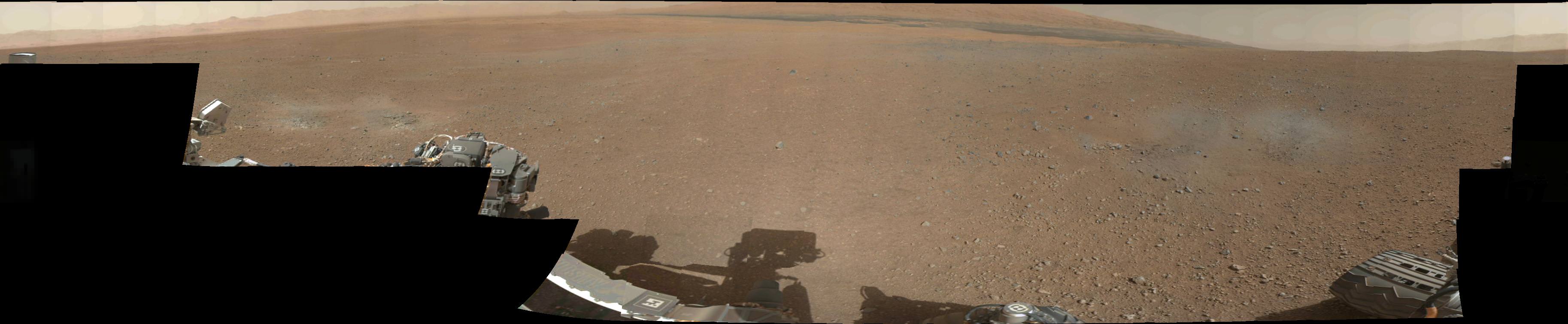
Image Caption: Curiosity Looks Away from the Sun – This is the first 360-degree panoramic view from NASA’s Curiosity rover, taken with the Navigation cameras. Most of the tiles are thumbnails, or small copies of the full-resolution images that have not been sent back to Earth yet. Two of the tiles near the center are full-resolution. Mount Sharp is to the right, and the north Gale Crater rim can be seen at center. The rover’s body is in the foreground, with the shadow of its head, or mast, poking up to the right. These images were acquired at 3:30 pm on Mars, or the night of Aug. 7 PDT (early morning Aug. 8 EDT). Thumbnails are 64 by 64 pixels in size; and full-resolution images are 1024 by 1024 pixels. Credit: NASA/JPL-Caltech

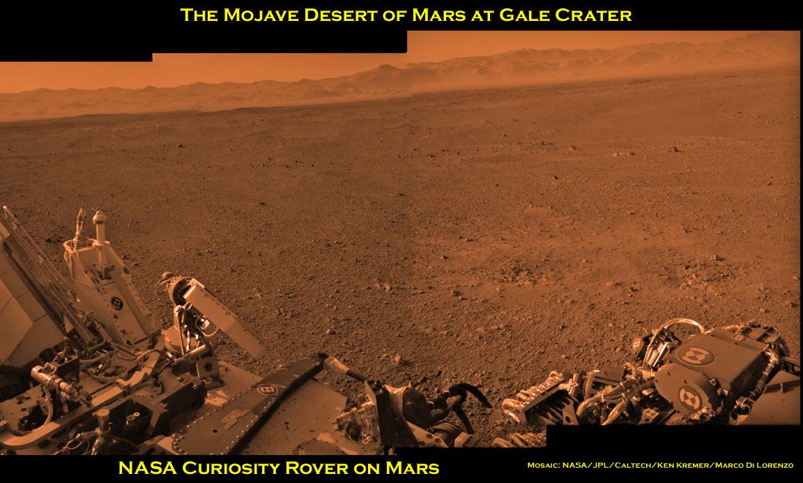
Image Caption: Looking to Martian bedrock and Gale Carter North Rim, Enhanced Mosaic- This mosaic was assembled from the first two full resolution Navcam images returned by Curiosity on Sol 2 (Aug 8) and enhanced to bring out further details. Processing by Ken Kremer and Marco Di Lorenzo. Topsoil in the foreground has been excavated by the descent landing thrusters to expose what the team believes is bedrock. Credit: NASA/JPL-Caltech/Ken Kremer/Marco di Lorenzo

“These Navcam images indicate that our powered descent stage did more than give us a great ride, it gave our science team an amazing freebie,” said John Grotzinger, project scientist for the mission from the California Institute of Technology in Pasadena. “The thrust from the rockets actually dug a one-and-a-half-foot-long [0.5-meter] trench in the surface. It appears we can see Martian bedrock on the bottom. Its depth below the surface is valuable data we can use going forward.”

Gale Crater is unlike anything we’ve seen before on Mars.

It also distinctly reminded Grotzinger of Earth and looked to him like the rover set down in the Mojave desert. “The thing that’s amazing about this is to a certain extent the first impression you get is how earth-like this seems, looking at that landscape.”

Curiosity carries 10 science instruments with a total mass 15 times as large as the science payloads on NASA’s Mars rovers Spirit and Opportunity. Some of the tools, such as a laser-firing instrument for checking rocks’ elemental composition from a distance, are the first of their kind on Mars. Curiosity will use a drill and scoop, which are located at the end of its robotic arm, to gather soil and powdered samples of rock interiors, then sieve and parcel out these samples into the rover’s analytical laboratory instruments.

So far everything is going very well with Curiosity’s mechanical and instrument checkout. And there is even more power than expected from the RTG nuclear power source.

“We have more power than we expected and that’s going to be fantastic for being able to keep the rover awake longer,” said Mission manager Jennifer Trosper of JPL.

Ken Kremer

Looking to Martian bedrock and Gale Carter North Rim, Enhanced Mosaic with False Color- This mosaic was assembled from the first two full resolution Navcam images returned by Curiosity on Sol 2 (Aug 8) and enhanced and colorized to bring out further details. Processing by Ken Kremer and Marco Di Lorenzo. Topsoil in the foreground has been excavated by the descent landing thrusters to expose what the team believes is bedrock. Credit: NASA/JPL-Caltech/Ken Kremer/Marco di Lorenzo

See the “Martian Triangle” in the Sky Tonight!

If — like me — you’ve been focusing on all the great images and news coming from the Mars Science Laboratory, perhaps you’ve missed the great view of the “Martian Triangle,” now visible in the night sky at twilight! Astrophotographer John Chumack hasn’t missed the view. This image is from August 6, 2012 from his observatory in Yellow Springs, Ohio.

The Martian Triangle show starts at twilight, and you can find it by looking low in the southwestern sky. The star at the top is actually the planet Saturn, the star on the bottom left is Spica, and the bright spot on bottom right is the planet Mars. And remember, somewhere in your field of view, there’s a few spacecraft on and around Mars and another orbiting Saturn.

John took this image with a modified Canon Rebel Xsi DSLR and a 47mm Lens, at F5.6, ISO 800, 10 second exposure. See more of John’s wonderful astrophotos at his Flickr page or at his website, Galactic Images.

Want to get your astrophoto featured on Universe Today? Join our Flickr group or send us your images by email (this means you’re giving us permission to post them). Please explain what’s in the picture, when you took it, the equipment you used, etc.

A Panorama of Curiosity’s Surroundings

Taken this morning (mission Sol 2) with the rover’s left Navcam, here’s a high-res panorama of Curiosity’s view at its landing site within Gale crater. The wide-angle view was assembled from two separate raw images, so while the mountainous rim of the crater is lined up horizontally there’s some distortion in alignment of objects closer to the rover due to the angle of the Navcam lens. Still, it’s a very cool view of Curiosity’s surroundings!

See the latest images from the MSL mission here, and check out 3D anaglyph images from Curiosity here.

Image: NASA/JPL-Caltech. Edited by J. Major.

(Image updated to link to full-size version.)

Mount Sharp on Mars: 1st 2-D and 3-D Views of Curiosity’s Ultimate Mountain Goal

Image Caption: Clear View on Mars – This image comparison shows a view through a Hazard-Avoidance camera on NASA’s Curiosity rover before and after the clear dust cover was removed. Both images were taken by a camera at the front of the rover. Mount Sharp, the mission’s ultimate destination, looms ahead. See the first 3 D and 2 D full res images with no dust cover, below. Image credit: NASA/JPL-Caltech

Curiosity, NASA’s new car sized rover on Mars has sent back her first breathtaking views of Mount Sharp, the huge nearby mountain that enticed scientists to set Gale Crater as her touchdown goal.

And already within the first 2 Sols, or martian days, the rover has beamed back magnificent 2D and 3 D vistas of the landscape surrounding her.

The unprecedented rocket powered “Sky Crane” descent maneuver that lowered Curiosity by cables upon the Red Planet’s surface rover with pinpoint accuracy, set her down in a position inside Gale Crater that fortuitously pointed her front Hazard Avoidance (Hazcam) cameras towards a stupendous panoramic view of Mount Sharp.

The terrain is strewn with small pebbles that may stem from a nearby alluvial fan through which liquid water flowed long ago, scientist think.

The top image set shows the spectacular side by side views of Mount Sharp before and after the protective dust covers were popped off.

Mount Sharp is taller than Mount Ranier, the tallest mountain in the US in the lower 48 states. It’s about 3.5 miles (5.5 km) high.

Curiosity is roughly 6 km distant from Mount Sharp, as the martian crow flies.

The image below is the first full resolution Hazcam version of Mount Sharp.

Curiosity’s Early Views of Mars. This full-resolution image shows one of the first views from NASA’s Curiosity rover, which landed on Mars the evening of Aug. 5 PDT (early morning hours Aug. 6 EDT). It was taken through a “fisheye” wide-angle lens on one of the rover’s front Hazard-Avoidance cameras. These engineering cameras are located at the rover’s base. Image credit: NASA/JPL-Caltech

Here’s the first 3D version of Mount Sharp assembled from both front cameras.

Image Caption: 3-D View from the Front of Curiosity. This image is a 3-D view in front of NASA’s Curiosity rover, which landed on Mars on Aug. 5 PDT (Aug. 6 EDT). The anaglyph was made from a stereo pair of Hazard-Avoidance Cameras on the front of the rover. Mount Sharp, a peak that is about 5.5 kilometers (3.4 miles) high, is visible rising above the terrain, though in one “eye” a box on the rover holding the drill bits obscures the view. This image was captured by Hazard-Avoidance cameras on the front of the rover at full resolution shortly after the rover landed. It has been linearized to remove the distorted appearance that results from its fisheye lens. Credit: NASA/JPL-Caltech

Ken Kremer

Curiosity Beams 1st Color Image from Mars

Image caption: This murky view from Curiosity shows the martian landscape looking north to the rim from inside the Gale Crater landing site and is her first color image beamed back to Earth. It’s murky because the dust cover is still attached. See full MAHLI image below. Also see below full res Hazcam image of crater rim. Credit: NASA/JPL-Caltech/Malin Space Science Systems

NASA’s Curiosity Mars rover has beamed back her first color view since touchdown, showing a view of the alien landscape pointing northward towards the eroded rim of Gale crater.

The picture was snapped by the rovers Mars Hand Lens Imager (MAHLI) camera on the afternoon of the first day after the pinpoint landing – signified as Sol 1 on Aug. 6, 2012.

The MAHLI image looks murky because the protective dust cover is still in place and is coated with a film of martian dust sprayed up by the descent retrorockets during the terminal phase of the hair-raising landing on Aug 5/6.

The camera’s dust cover is intentionally transparent so that initial images can still be snapped through the cover before it’s popped off in about a week.

MAHLI is located on the turret at the end of the rover’s 8 foot long robot arm which has been stowed in place on the front left side of Curiosity since long before the Nov. 26 liftoff from Cape Canaveral, Florida.

In the stowed position, MAHLI is rotated about 30 degrees as seen in the image below. The top image has been rotated to correct for the tilt and shows the sky “up” as Curiosity is actually sitting on the Martian surface.


Image caption: This full frame view from Curiosity shows the martian landscape looking north to the rim from inside the Gale Crater landing site and is her first color image beamed back to Earth. It’s murky because the dust cover is still attached. The image is from the MAHLI camera on the robot arm and currently in the stowed position. It has been rotated 30 degress. Credit: NASA/JPL-Caltech/Malin Space Science Systems

During her 2 year prime mission, Curiosity’s goal is to determine if Mars was ever capable of supporting microbial life, past or present and to search for the signs of life in the form of organic molecules with a payload of 10 science instruments weighing 15 times more than any prior roving vehicle.

Curiosity is the 3rd generation of NASA rover’s delivered to the Red Planet

Ken Kremer

Image Caption: Looking Back at the Crater Rim – This is the full-resolution version of one of the first images taken by a rear Hazard-Avoidance camera on NASA’s Curiosity rover, which landed on Mars the evening of Aug. 5 PDT (morning of Aug. 6 EDT). The image was originally taken through the “fisheye” wide-angle lens, but has been “linearized” so that the horizon looks flat rather than curved. The image has also been cropped. A Hazard-avoidance camera on the rear-left side of Curiosity obtained this image. Part of the rim of Gale Crater, which is a feature the size of Connecticut and Rhode Island combined, stretches from the top middle to the top right of the image. One of the rover’s 20 inch wide wheels can be seen at bottom right. Image credit: NASA/JPL-Caltech

Curiosity’s Awesome Landing “Trailer”

MSL Curiosity is busy investigating the surface of Mars, to see if that planet could have harbored life. Image: NASA/JPL/Cal-Tech

This short compilation video is a great overview of all the action on landing night for the Curiosity rover: Suspense, intrigue and definitely a happy ending. Only this “made for movie theater”-like trailer really happened.

UPDATE: We’ve gotten comments and questions that some people can’t see the video above, so we’ve added the You Tube version, below.
Continue reading “Curiosity’s Awesome Landing “Trailer””

“Nailed It!” HiRISE Captures Incredible Image of Curiosity’s Descent to Mars

The HiRISE team has outdone themselves this time. Using their incredible instrument, the High Resolution Imaging Science Experiment, they have captured an absolutely amazing image of the Curiosity rover, descending on a parachute through Mars’ atmosphere.

“Nailed it!” Tweeted Christian Schaller of the HiRISE team. “My goodness, @MarsCuriosity you look pretty.”

Wow!

Full image below.

Link to original image (2.7 MB)

Schaller told Universe Today that the MSL Navigation team, the MRO Navigation team and the MRO FET (flight engineering team) “seriously rock. Seriously.”

The planning by those teams made this image possible.

Schaller is the software developer responsible for the primary planning tools the MRO and HiRISE targeting specialists and science team members use to plan their images.

“The Mars background looks a little blurry or smeared because we set up the timing to capture Curiosity, not the Martian surface,” Schaller said via email after the image was released at the press conference from JPL on Monday morning.

The image was set up so that as MSL was descending, MRO “slewed” the HiRISE field of view across the expected descent path. But obviously, MRO didn’t have to slew too much. “We were almost directly overhead, and had a very, very small angle to take the image,” said HiRISE team member Sarah Malkovich at the press conference. “MRO was essentially overhead.”

HiRISE Principal Investigator Alfred McEwen said before the landing that they expected only a 60% chance of success.

McEwen wrote the HiRISE website of the image:

The parachute appears fully inflated and performing perfectly. Details in the parachute such as the band gap at the edges and the central hole are clearly visible. The cords connecting the parachute to the backshell cannot be seen, although they were seen in the image of Phoenix descending, perhaps due to the difference in lighting angles.

The bright spot on the backshell containing MSL might be a specular reflection off of a shiny area. MSL was released from the backshell sometime after this image was acquired.

This view is one product from an observation made by HiRISE targeted to the expected location of MSL about 1 minute prior to landing. It was captured in HiRISE CCD RED1, near the eastern edge of the swath width (there is a RED0 at the very edge). This means that MSL was a bit further east or downrange than predicted.

The image scale is 33.6 cm/pixel.

MRO was 340 km away from Curiosity when the image was taken, and that is line of sight distance, said Malkovich. “HiRISE has taken over 120 pictures of Gale Crater in preparation for MSL’s mission, but I think this is the coolest one,” she said.

McEwen said more details and image products will be available and we will post them as soon as they are available.

This animation shows how HiRISE planned to capture MSL’s descent:

Malkovich said that the HiRISE team already has plans to take images of Curiosity sitting on the surface of Mars later this week that will be of higher resolution than the descent image.

President Obama Hails NASA Curiosity rover landing on Mars

Image Caption: Landing ellipse for Curiosity rover inside Gale Crater at the foot of Mount Sharp on Mars and will attempt to climb the mountain later in the mission. Credit: NASA

US President Barack Obama hailed the spectacular landing success of NASA’s Curiosity rover on Aug. 6 inside Gale Crater and eagerly awaits the discoveries to come. More accolades for Curiosity and the rover team are pouring in from all across the globe.

The White House issued the following statement:

Statement by the President on Curiosity Landing on Mars

“Tonight, on the planet Mars, the United States of America made history.

The successful landing of Curiosity – the most sophisticated roving laboratory ever to land on another planet – marks an unprecedented feat of technology that will stand as a point of national pride far into the future. It proves that even the longest of odds are no match for our unique blend of ingenuity and determination.

Tonight’s success, delivered by NASA, parallels our major steps forward towards a vision for a new partnership with American companies to send American astronauts into space on American spacecraft. That partnership will save taxpayer dollars while allowing NASA to do what it has always done best – push the very boundaries of human knowledge. And tonight’s success reminds us that our preeminence – not just in space, but here on Earth – depends on continuing to invest wisely in the innovation, technology, and basic research that has always made our economy the envy of the world.

I congratulate and thank all the men and women of NASA who made this remarkable accomplishment a reality – and I eagerly await what Curiosity has yet to discover.”

The 1 ton Mini Cooper sized robot geologist and roving chemistry lab is seeking the signs of life on Mars and is loaded with 165 pounds of the most sophisticated science instruments ever delivered to the surface of the Red Planet.

During a two-year prime mission, Curiosity the rover will investigate whether the region has ever offered conditions favorable for microbial life, and search for organic molecules – the chemical ingredients for life.

Ken Kremer