Masten’s Xombie Tests a Mars EDL-type Trajectory

Could one of the next landings on Mars be led by a commercial company? Masten Space Systems vertical take-off and landing vehicle, Xombie, recently tested powered descent and landing trajectory algorithms that could be used for future Mars Entry Descent & Landing (EDL) applications.

“You may have noticed we’ve been flying Xombie a lot lately doing some interesting things,” wrote the Masten team on their website. “We just finished the third leg of a flight campaign on Xombie that expands the boundaries of what we believe to be the nation’s leading terrestrial landing testbed.”

These very fun-to-watch test flights were completed by Masten for the Jet Propulsion Laboratory to test its powered descent and landing trajectory optimization algorithms for future EDL applications.

“It may look easy, but flying VTVL is really hard,” said Masten Space Systems CTO David Masten on Twitter.


The company said the flights this week reached a higher translation velocity than the previous flights and successfully expanded Xombie’s flight envelope. The flight was controlled by Masten’s own Guidance, Navigation & Control system.

The flight ascended to 476.4 meters before translating downrange 750 meters at a horizontal velocity of 24 meters per second (53 mph).
“As far as we know, the 750 meter translation flight represents the longest terrestrial translation flight ever undertaken by a rocket powered vertical takeoff, vertical landing craft” said the Masten website. “You can bet there were a lot of high fives around the Masten team after this flight!”

This was the third test Masten did for JPL to validate their algorithm, and all objectives were successfully met.

Masten Space Systems’ Xombie rocket with Draper Laboratory’s GENIE flight control system takes an untethered flight from the Mojave Air and Space Port. (Photo courtesy of Draper Laboratory)

Scientists Find Clues of Plate Tectonics on Mars

Valles Marineris NASA World Wind map Mars Credit NASA

Caption: Valles Marineris NASA World Wind Map Mars Credit: NASA

Until now, Earth was thought to be the only planet with plate tectonics. But a huge “crack” in Mars’ surface — the massive Valles Marinaris — shows evidence of the movement of huge crustal plates beneath the planet’s surface, meaning Mars may be showing the early stages of plate tectonics. This discovery can perhaps also shed light on how the plate tectonics process began here on Earth.

Valles Marineris is no ordinary crack on the Martian surface. It is the longest and deepest system of canyons in the Solar System. Stretching nearly 2,500 miles, it is nine times longer than Earth’s Grand Canyon.

An Yin, a planetary geologist and UCLA professor of Earth and space sciences, analyzed satellite images from THEMIS (Thermal Emission Imaging System), on board the Mars Odyssey spacecraft, and from the HIRISE (High Resolution Imaging Science Experiment) camera on NASA’s Mars Reconnaissance Orbiter.

“When I studied the satellite images from Mars, many of the features looked very much like fault systems I have seen in the Himalayas and Tibet, and in California as well, including the geomorphology,” he said.

The two plates that Yin calls Valles Marineris North and Valles Marineris South are moving approximately 93 miles horizontally relative to each other. By comparison, California’s San Andreas Fault, which is similarly over the intersection of two plates, has moved about twice as much, because Earth is about twice the size of Mars.

Yin believes Mars has no more than two plates whereas Earth has seven major plates and dozens of smaller ones. As Yin puts it “Earth has a very broken ‘egg shell,’ so its surface has many plates; Mars’ is slightly broken and may be on the way to becoming very broken, except its pace is very slow due to its small size and, thus, less thermal energy to drive it. This may be the reason Mars has fewer plates than on Earth.”

Mars also has several long, straight chains of volcanoes, including three that make up the Tharsis Montes, three large shield volcanoes which includes Olympus Mons, the tallest mountain in the Solar System at 22 km high. These volcanic chains may have formed from the motion of a plate sitting over a “hot spot” in the Martian mantle, in the same way the Hawaiian Islands are thought to have formed here on Earth. Yin also identified a steep cliff similar to cliffs in California’s Death Valley, which are generated by a fault, as well as a very smooth and flat side of a canyon wall which Yin says is also strong evidence of tectonic activity.

Yin also suggests that the fault is shifting occasionally, and may even produce “Marsquakes” every now and again. “I think the fault is probably still active, but not every day. It wakes up every once in a while, over a very long duration — perhaps every million years or more,” he said.

It is not known how far beneath the surface the plates on Mars are located. Yin admits “I don’t quite understand why the plates are moving with such a large magnitude or what the rate of movement is; maybe Mars has a different form of plate tectonics,” Yin said. “The rate is much slower than on Earth.”

“Mars is at a primitive stage of plate tectonics,” Yin added. “It gives us a glimpse of how the early Earth may have looked and may help us understand how plate tectonics began on Earth.”

Yin’s study was published in the August issue of the journal Lithosphere and he also plans to publish a follow-up paper hoping to shed more light on plate tectonics on both Mars and Earth.

Read the abstract.

Find out more at the

Which Planet is This? A Gale Crater Doppelganger

The Badwater Basin region of California’s Death Valley acquired by NASA’s Earth Observing-1 satellite (EO-1) on October 23, 2002. Alluvial fans in the image are remarkably similar to the terrain that the Curiosity rover will explore on Mars. Image and annotations from NASA Earth Observatory

Leave it to NASA’s Earth Observtory folks to come up with a terrestrial image that captures the familiar terrain the car-sized rover Curiosity will explore on Mars.

“You would really be forgiven for thinking that NASA was trying to pull a fast one on you, and we actually put a rover out in the Mojave Desert and took a picture,” said project scientist John Grotzinger during a recent press conference.

Curiosity set down along a fan-shaped apron of dirt and debris known as an alluvial fan. The landform likely formed when liquid water flowed down the side of Gale Crater through a network of stream channels and valleys onto the crater floor. Although no liquid water seems to exist on the surface of Mars, the tell-tale traces of liquid water’s flow is abundant.

Gaze down onto the Badwater Basin area of California’s Death Valley National Park in this image from NASA’s Earth Observing-1 Satellite (EO-1). Take a peek at the earthimagified version. Alluvial fans are abundant in this image. Occasional storms send flash floods rushing down canyons in this arid landscape. The water transports sediment from the mountains and deposits them in the fan-shaped patterns we see in the image. The white region to the left of the image is a salt flat; the remains of a dried up lake. Scientists note that Gale Crater is also a basin with no outlets so water that pooled in the crater may leave behind similar salts and deposits.

The NASA site also points out that many features, including wind, volcanism, and alternating wet and dry conditions, make this area a perfect laboratory for planning missions to Mars. In fact, a dark patch just north of the large alluvial fan to the left of the image is called Mars Hill due to its similarity to features seen at the Viking 1 landing site. Viking 1 landed on Mars July 20, 1976.

There is a primary difference between the landscapes and features of Gale Crater and Badwater Basin and that is age. The features of Death Valley are billions of years younger than those found on Mars and the site continues to be shaped by water. Scientists believe water stopped flowing on Mars billions of years ago; the sediments deposited by ancient rivers on Mars buried by eons of wind-driven erosion.

John Williams is a science writer and owner of TerraZoom, a Colorado-based web development shop specializing in web mapping and online image zooms. He also writes the award-winning blog, StarryCritters, an interactive site devoted to looking at images from NASA’s Great Observatories and other sources in a different way. A former contributing editor for Final Frontier, his work has appeared in the Planetary Society Blog, Air & Space Smithsonian, Astronomy, Earth, MX Developer’s Journal, The Kansas City Star and many other newspapers and magazines.

Curiosity’s Landing Through the Eyes of One of Her 3,000 Builders

We all have seminal moments that mark our lives; some just are way more cool than others. Mark Rober designs spacecraft at the Jet Propulsion Laboratory and is just one of over 3,000 people who helped design, build, tweak, launch, navigate and land the Curiosity Rover on Mars. “I spent 7 years working NASA’s Curiosity Rover,” Rober said via Twitter. “I made this video to try to capture what it felt like to see her land.”

Seven years of his life came down to seven minutes of terror… or in Mark’s case, seven minutes of shivering.

Congrats, Mark, and to all your thousands of compatriots. Thanks for sharing the journey with the rest of us.

Curiosity Wheels Initial Rove in a Week on Heels of Science and Surgery Success

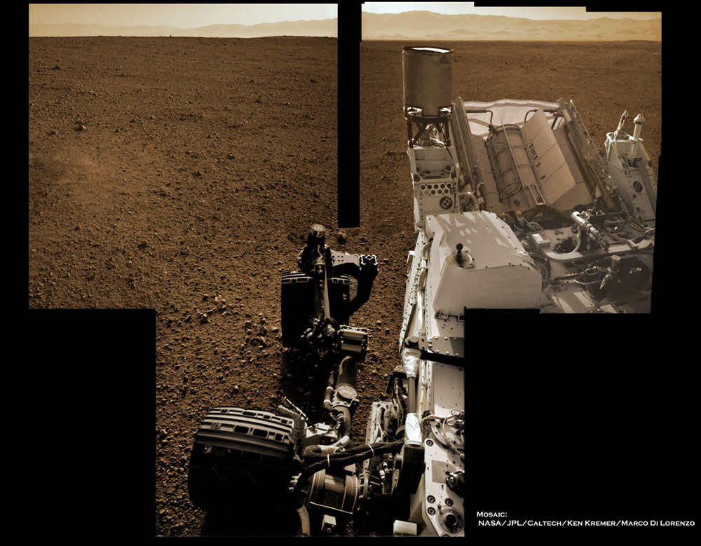
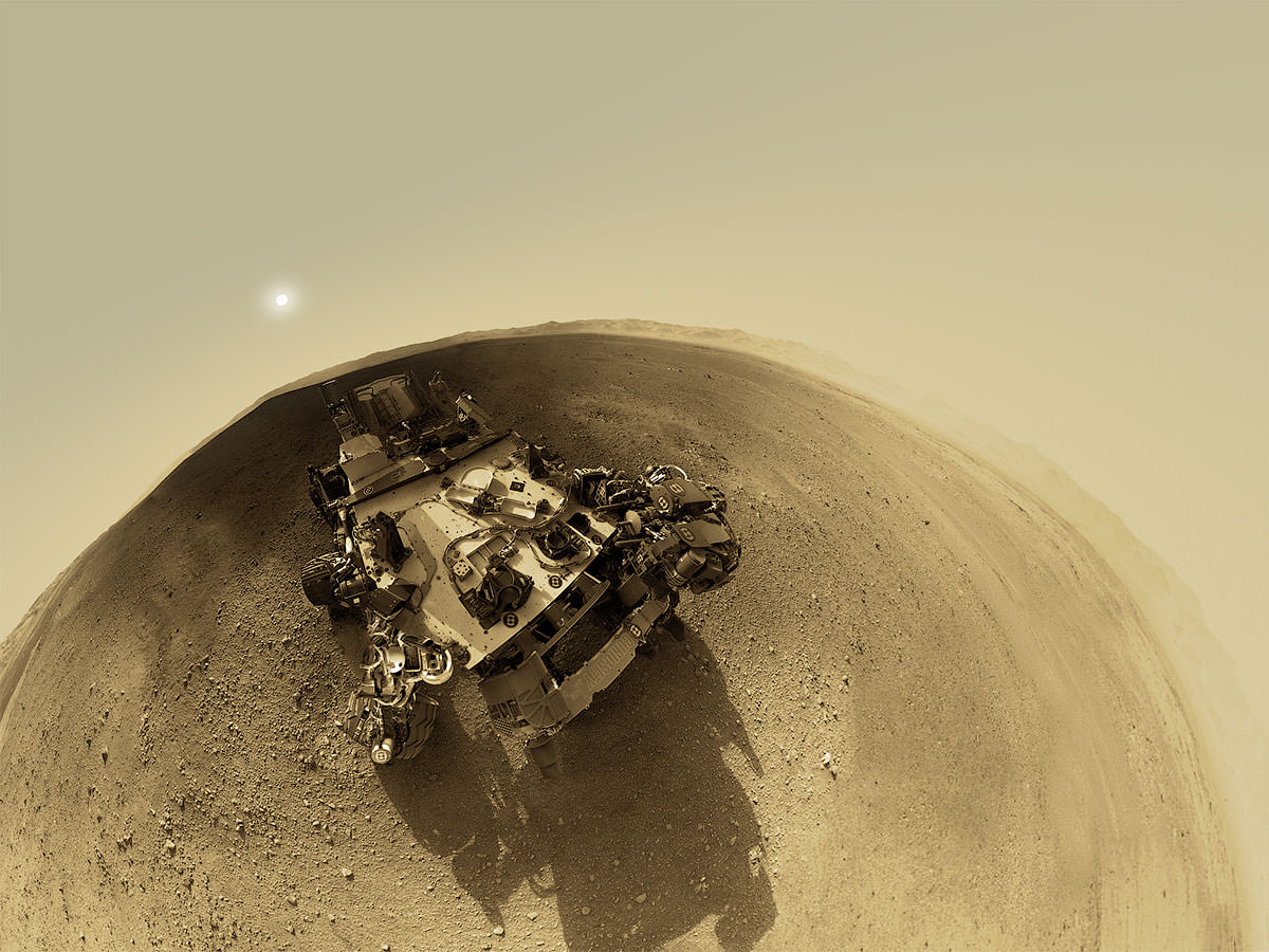
Image Caption: Curiosity’s Wheels Set to Rove soon Mars inside Gale Crater after ‘brain transplant’. This colorized mosaic shows Curiosity wheels, nuclear power source and pointy low gain antennea (LGA) in the foreground looking to the eroded northern rim of Gale Crater in the background. The mosaic was assembled from full resolution Navcam images snapped by Curiosity on Sol 2 on Aug. 8. Image stitching and processing by Ken Kremer and Marco Di Lorenzo. see black & white version below. Credit: NASA/JPL-Caltech/Ken Kremer/Marco Di Lorenzo

Curiosity’s weekend “Brain transplant” proceeded perfectly and she’ll be ready to drive across the floor of Gale Crater in about a week, said the projects mission managers at a NASA news briefing on Tuesday, Aug. 14. And the team can’t wait to get Curiosity’s 6 wheels mobile on the heels of a plethora of science successes after just a week on Mars.

Over the past 4 sols, or Martian days, engineers at NASA’s Jet Propulsion Lab (JPL) successfully uploaded the new “R10” flight software that is required to carry out science operations on the Red Planet’s surface and transform the car-sized Curiosity from a landing vehicle into a fully fledged rover.

The step by step flight software transition onto both the primary and backup computers “went off without a hitch”, said mission manager Mike Watkins of JPL at the news briefing. “We are ‘Go’ to continue our checkout activities on Sol 9 (today).”
Watkins added that the electronic checkouts of all the additional science instruments tested so far, including the APXS, DAN and Chemin, has gone well. Actual use tests are still upcoming.

“With the new flight software, we’re now going to test the steering actuators on Sol 13, and then we are going to take it out for a test drive here probably around Sol 15,” said Watkins . “We’re going to do a short drive of a couple of meters and then maybe turn and back up.”

See our rover wheel mosaic above, backdropped by the rim of Gale Crater some 15 miles away.

Image Caption: Curiosity landed within Gale Crater near the center of the landing ellipse. The crater is approximately the size of Connecticut and Rhode Island combined. This oblique view of Gale, and Mount Sharp in the center, is derived from a combination of elevation and imaging data from three Mars orbiters. The view is looking toward the southeast. Mount Sharp rises about 3.4 miles (5.5 kilometers) above the floor of Gale Crater. Credit: NASA/JPL-Caltech/ESA/DLR/FU Berlin/MSSS

Curiosity made an unprecedented pinpoint landing inside Gale Crater using the rocket powered “Sky Crane” descent stage just a week ago on Aug. 5/6 and the team is now eager to get the huge rover rolling across the Martian plains towards the foothills of Mount Sharp, about 6 miles (10 km) away as the Martian crow flies.

“We have a fully healthy rover and payload,” said Ashwin Vasavada, Mars Science Laboratory (MSL) deputy project scientist. “We couldn’t be happier with the success of the mission so far. We’ve never had a vista like this on another planet before.”

“In just a week we’ve done a lot. We’ve taken our 1st stunning panorama of Gale crater with focusable cameras, 1st ever high energy radiation measurement from the surface, the 1st ever movie of a spacecraft landing on another planet and the 1st ground images of an ancient Martian river channel.”

A high priority is to snap high resolution images of all of Mount Sharp, beyond just the base of the 3.4 mile (5.5 km) tall mountain photographed so far and to decide on the best traverse route to get there.

“We will target Mount Sharp directly with the mastcam cameras in the next few days,” said Watkins.

Climbing the layered mountain and exploring the embedded water related clays and sulfate minerals is the ultimate goal of Curiosity’s mission. Scientists are searching for evidence of habitats that could have supported microbial life.

Curiosity will search for the signs of life in the form of organic molecules by scooping up soil and rock samples and sifting them into analytical chemistry labs on the mobile rovers’ deck.

Vasavada said the team is exhaustively discussing which terrain to visit and analyze along the way that will deliver key science results. He expects it will take about a year or so before Curiosity arrives at the base of Mount Sharp and begins the ascent in between the breathtaking mesas and buttes lining the path upwards to the sedimentary materials.

Watkins and Vasavada told me they are confident they will find a safe path though the dunes and multistory tall buttes and mesas that line the approach to and base of Mount Sharp.

“Curiosity can traverse slopes of 20 degrees and drive over 1 meter sized rocks. The team has already mapped out 6 potential paths uphill from orbital imagery.”

“The science team and our rover drivers and really everybody are kind of itching to move at this point,” said Vasavada. “The science and operations teams are working together to evaluate a few different routes that will take us eventually to Mount Sharp, maybe with a few waypoints in between to look at some of this diversity that we see in these images. We’ll take 2 or 3 samples along the way. That’s a few weeks work each time.”

Caption: Destination Mount Sharp. This image from NASA’s Curiosity rover looks south of the rover’s landing site on Mars towards Mount Sharp. Colors have been modified as if the scene were transported to Earth and illuminated by terrestrial sunlight. This processing, called “white balancing,” is useful for scientists to be able to recognize and distinguish rocks by color in more familiar lighting. Credit: NASA/JPL-Caltech/MSSS

“We estimate we can drive something like a football field a day once we get going and test out all our driving capabilities. And if we’re talking about a hundred football fields away, in terms of 10 kilometers or so, to those lower slopes of Mount Sharp, that already is a hundred days plus.”

“It’s going to take a good part of a year to finally make it to these sediments on Mount Sharp and do science along the way,” Vasavada estimated.

The 1 ton mega rover Curiosity is the biggest and most complex robot ever dispatched to the surface of another planet and is outfitted with a payload of 10 state of the art science instruments weighing 15 times more than any prior roving vehicle.

Ken Kremer

Image Caption: Curiosity’s Wheels Set to Rove soon Mars inside Gale Crater. This mosaic shows Curiosity wheels, nuclear power source and pointy low gain antennea (LGA) in the foreground looking to the eroded northern rim of Gale Crater in the background. The mosaic was assembled from full resolution Navcam images snapped by Curiosity on Sol 2 on Aug. 8. Image stitching and processing by Ken Kremer and Marco Di Lorenzo. Credit: NASA/JPL-Caltech/Ken Kremer/Marco Di Lorenzo – www.kenkremer.com

Image Caption: Mosaic of Mount Sharp inside Curiosity’s Gale Crater landing site. Gravelly rocks are strewn in the foreground, dark dune field lies beyond and then the first detailed view of the layered buttes and mesas of the sedimentary rock of Mount Sharp. Topsoil at right was excavated by the ‘sky crane’ landing thrusters. Gale Crater in the hazy distance. This mosaic was stitched from three full resolution Navcam images returned by Curiosity on Sol 2 (Aug 8) and colorized based on Mastcam images from the 34 millimeter camera. Processing by Ken Kremer and Marco Di Lorenzo. Credit: NASA/JPL-Caltech/Ken Kremer/Marco Di Lorenzo

A 360-Degree ‘Street View’ From Mars

360-degree panoramic image of the Martian landscape surrounding NASA’s Curiosity. Credit: Andrew Bodrov

After seeing all the amazing imagery so far from NASA’s Mars rover Curiosity, I know everyone wants to go there and take in the visual treats of Gale Crater. With the help of a 360-degree panorama you can virtually explore Curiosity’s landing site; sort of like a Martian version of Google’s Street View.

Take a martian minute to explore the panorama at 360pano.eu.

Photographer Andrew Bodrov stitched together images from Curiosity’s navigation cameras to create the panorama. “After seeing some of the stitches of Curiosity’s images at NASA’s website, I decided to stitch the panorama myself,” Bodrov told Universe Today.

He uses PTGui panoramic stitching software from New House Internet Services BV (http://www.ptgui.com) to create the 360-degree view of the mountains and sky surrounding the car-sized rover that successfully landed on Mars on August 6th.

“NASA has still not published enough source material to assemble a complete panorama in color,” Bodrov says. He used a color filter to make the images more representable. He also added that the sky and sun in the panorama were added in Adobe Photoshop. He used the size of the Sun seen in this spectacular image of a Martian sunset from NASA’s Spirit rover taken in 2005 as a guide.

While Bodrov says the high-resolution images themselves are amazing, just seeing a picture of another world is more inspiring. “It’s very nice to see the achievements of humanity which allows you to see a picture of another world,” he said.

Bodrov says he has more than 12 years experience creating panoramas including an awesome panorama (complete with sound) for the Russian Federal Space Agency of a Soyuz/Progress launch from the Baikonur Cosmodrome in August 2011.

Image caption: Planet Baikonur courtesy of Andrew Bodrov

What Curiosity Looks Like From 200 Kilometers Up

Here’s a look down at Curiosity from the HiRISE camera aboard NASA’s Mars Reconnaissance Orbiter, orbiting approximately  200 km (125 miles) above the surface of Mars. This new image, released today, shows the rover inside Gale Crater surrounded by a skirt of blue-tinted material, including several bright radiating marks –the  result of the descent stage rockets clearing layers of dust from the surface.

In this exaggerated-color view the blue indicates material of a different texture and composition than the surrounding area. HiRISE captures images in visible light wavelengths as well as near-infrared, which we can’t see. To us, the blue material would look grey.

North is up, and Curiosity’s ultimate exploration target, Gale Crater’s central peak, Mount Sharp, is off frame to the lower right.

Click here for a full-size version of the HiRISE image scan, showing the scene above plus some areas further north and south — including portions of the dark dune fields visible in recent images from Curiosity.

It’s nice to know that Curiosity has friends in high places!

Image: NASA/JPL/University of Arizona


Curiosity Getting Ready to Rove

Here’s a look at what the Curiosity team has planned for the rover this week. Team member Jessica Samuels provides an update on developments and status of the mission now that it’s preparing to explore Gale Crater. Curiosity carries 10 science instruments with a total mass 15 times as large as the science payloads on NASA’s Mars rovers Spirit and Opportunity. Some of the tools, such as a laser-firing instrument for checking rocks’ elemental composition from a distance, are the first of their kind on Mars. Curiosity will use a drill and scoop, which are located at the end of its robotic arm, to gather soil and powdered samples of rock interiors, then sieve and parcel out these samples into the rover’s analytical laboratory instruments.
Continue reading “Curiosity Getting Ready to Rove”

President Obama Calls with Congratulations for Mars Science Laboratory Team

US President Barack Obama called up the Mars Science Laboratory team at the Jet Propulsion Laboratory today, August 13, congratulating them on the perfect landing of the Curiosity rover one week ago today.

“What you did on Mars was incredibly impressive,” the President said, “with those 76 pyrotechnics going on in perfect succession, the 500,000 lines of code working exactly the way you guys had ordered them, it’s really mind boggling what you’ve been able to accomplish. Being able to get that whole landing sequence to work the way you did, it’s a testimony to your team.”

Obama specifically congratulated Charles Elachi, the head of JPL, the entry, descent and landing lead, Adam Steltzner for the audacious Sky Crane system.

“What you accomplished embodied the American spirit and your passion and your commitment is making a difference and your hard work is now paying dividends, because our expectation is that Curiosity is going to be telling us things that we did not know before and laying the groundwork for an even more audacious undertaking in the future, and that’s a human mission to the Red Planet.”

Obama joked about letting him know right away if they find any Martians, and perhaps getting a Mohawk, just like Bobak Ferdowsi, a systems engineer in JPL’s mission control who became an unexpected “star of the show” on Sunday night’s webcast, for his American flag-themed stars and stripes Mohawk haircut.

“That’s going to be the new fashion at JPL,” Elachi replied.

“It does sound like NASA’s come a long way from the white shirts, black-rimmed glasses and the pocket protectors,” the President joked. “You guys are a little cooler than you used to be.”

Obama said his administration is putting a big focus on improving science, technology, engineering and math education; however, NASA and other science arms of the government are all facing massive cuts. Perhaps MSL has captured the President’s attention enough to, maybe, change his focus. Several people have sent messages to Obama via Twitter, such as this one:

A view of the crowd gathered at Times Square in New York City to watch the landing of Curiosity on Mars. Credit: @CSMuncyPhoto

Then Obama said, “I’m going to give you guys a personal commitment to protect these critical investments in science and technology, I thank you for devoting your lives to this cause and if, in fact, you do make contact with Martians, please let me know right away. I’ve got a lot of other things on my plate, but I suspect that that will go to the top of the list. Even if they’re just microbes, it will be pretty exciting.”

Obama said the incredible landing of Curiosity is the kind of thing that inspires kids across the country. “They are telling their moms and dads they want to be part of a Mars mission, maby even the first person to walk on Mars. That kind of inspiration is a by-product of the work that you have done.”

“You guys have done an outstanding job, you’ve made us all proud… you are examples of American know-how and ingenuity and we can’t wait to start hearing back from Curiosity and finding on what is going on.”

Mystery Blur in Mars Image Explained

When Curiosity executed a perfect six-wheel landing on Mars on the morning of August 6 to the excitement of millions worldwide — not to mention quite a few engineers and scientists at JPL — it immediately began relaying images back to Earth. Although the initial views were low-resolution and taken through dusty lens covers, features of the local landscape around the rover could be discerned… distant hills, a pebbly surface, the rise of Gale Crater’s central peak — and a curious dark blur on the horizon that wasn’t visible in later images.

What could it have been? Another bit of lens dust? An image artifact? A piece of ancient Martian architecture that NASA demanded be erased from the image? As it turns out, it was most likely something even cooler (or at least real): the result of Curiosity’s descent stage crash-landing into the Martian surface.

Seen in an image from NASA’s Mars Reconnaissance Orbiter’s HiRISE camera, the remnants of Curiosity’s descent to Mars are scattered around the landing site. The heat shield, parachute, back shell — and undeniably the star player of Curiosity’s EDL sequence, the descent stage and sky crane — all landed in relatively close proximity to where the rover touched down. As it turned out, Curiosity’s’s rear Hazcam happened to be aimed right where the sky crane landed after it severed Curiosity’s bridles and rocketed safely away — just as it had been shown in the landing animation.

See an infographic on Curiosity’s EDL timeline here.

Seen in the first images captured by Curiosity’s rear Hazcams just minutes after touchdown — but not in higher-resolution images acquired later — the dark blur is now thought to be a plume of dust and soil kicked up by the sky crane’s impact.

“We know that the cloud was real because we saw it in both the left and right rear Hazcams, so it wasn’t just a smudge on the lens cover or anything like that… and then 45 minutes later it was gone,” said Steven Sell, Deputy Operations for Entry, Descent and Landing at JPL, during an interview with Universe Today on Friday.

“When we were putting together the sequence of images of what would happen after touchdown, we specifically put in the Hazcam shots as soon as we could on the off chance that we would see something,” Sell said. “It was just one of those things where we had some choices we could make, and we said if we put these really close to landing maybe we’ll actually see part of the descent stage.”

Although capturing the sky crane or other part of the descent stage on camera was an intriguing idea, it wasn’t any particular goal of the mission.

“We know that the cloud was real because we saw it in both the left and right rear Hazcams, so it wasn’t just a smudge on the lens cover or anything like that.”

– Steven Sell, Deputy Operations for Entry, Descent and Landing at JPL in Pasadena, CA

“We literally weren’t even thinking about it,” Sell said. “It’s a total bonus that we were able to capture that.”

Unfortunately, the plume only appears in the initial Hazcam shots, which were taken through lens covers coated with dust from landing. It wasn’t until nearly an hour later that the covers were removed and clearer images were captured, and by then the plume was gone. Plus the Hazcams themselves are low-resolution by design — they’re more for navigation than landscape photography.

“Those cameras are not intended for doing that kind of science, or even any science at all,” said Sell. “They’re strictly engineering cameras.”

It’s been said that the best camera is the one you have with you, and in this case Curiosity’s best camera happened to be aimed in the right place at the right time. Plus the sky crane just so happened to land in view of the cameras that got turned on first, which wasn’t a guarantee.

“The descent stage had two possible directions to go: it could have gone forward or backward,” Sell explained. “The way it decides which way to go is whichever direction would take it more north. We knew that the science target is toward the south — the scientists want to study the mountain — and so we didn’t want to throw the descent stage toward the mountain.

Read: Curiosity’s First 360-Degree Color Panorama

“The good news is that the forward Hazcams were at a lower temperature upon landing, we knew they were going to be colder,” Sell said. “The cameras have to reach a certain temperature before they can take a picture, so we knew the rear Hazcams were going to get the picture first, and so the fact that the thing flew to the rear was another coincidence.”

About the same mass as the rover itself, the sky crane weighed about 800 kg (1700 lbs) at the time of impact  — including 100 kg of fuel — and hit going 100 mph. That’s going to kick up a good-sized plume (although exactly how large has yet to be determined.)

“It was one hell of an impact,” Sell said.

You can watch Steve Sell describe this and other data from the first few days of the MSL mission in the press conference held at JPL on Friday, August 10 below, and follow Sell on his Twitter feed here.


Images: NASA/JPL-Caltech. HiRISE image NASA/JPL/University of Arizona.