The Astronomy of Shakespeare

A portrait of William Shakespeare on the cover of the first Folio of his plays. Credit: Elizabethan Club of Yale University

With all this talk lately of rocks whizzing by Earth (or crashing through the atmosphere), it’s remarkable that we didn’t even know of space rocks a few centuries ago. The first asteroid, 1 Ceres, was discovered in 1801.

Dial back a few centuries, and we were still in the realm of a perfect universe with the Earth at the center. William Shakespeare’s (1564-1616) plays are full of these references. Universe Today recently stumbled across a 1964 Irish Astronomical Journal paper replete with examples.

Shakespeare was born about 20 years after Nicolaus Copernicus, whose book De revolutionibus orbium coelestium (On the Revolutions of the Celestial Spheres) laid out the case for the Sun-centered solar system. It took a while for Copernicus’ theories to take hold, however.

While bearing in mind that Shakespeare often wrote about historical personages, one passage from Troilus and Cressida demonstrates an example of the characters speaking of the Sun following the other planets in circles around the Earth.

The heavens themselves, the planets, and this centre,
Observe degree, priority and place.
Insisture, course, proportion, season, form,
Office, and custom, in all line of order:
And therefore is the glorious planet Sol
In noble eminence enthroned and sphered
Amidst the other …

An Earth-centered solar system had its problems when predicting the paths of the planets. Astronomers couldn’t figure out why Mars reversed in its path in the sky, for example.

The real explanation is the Earth “catching up” and passing Mars in its orbit, but astronomers in Shakespeare’s time commonly used “epicycles” (small circles in a planet’s orbit) to explain what was going on. Shakespeare wrote about this problem in Henry VI:

Mars his true moving, even as in the heavens,
So in the earth, to this day is not known.

However, the Bard displayed a more modern understanding of the Moon’s movement around the Earth, the paper points out. The Moon’s distance varies in its orbit, a fact spoken about in Othello, although note that Shakespeare attributes madness to the moon’s movements:

It is the very error of the moon;
She comes more near the earth than she was wont
And makes men mad.

For more examples — including what Shakespeare thought about astrology — you can check out the paper here.

10 Amazing 3-D Views from the Mars Reconnaissance Orbiter

The Dunes of 'Inca City.' Credit: NASA/JPL/University of Arizona.

These pictures require you to grab the 3-D glasses you have handy by your desk (if you don’t have a pair, here’s some great options for buying some) and get a “you-are-there” experience from the HiRISE camera on the Mars Reconnaissance Orbiter. Here, you can virtually tumble down crater walls, hover over steep cliffs, and see how layered bedrock appears from above.

Our lead image is of an area referred to as “Inca City,” the informal name given by Mariner 9 scientists in 1972 to a set of intersecting, rectilinear ridges, which some people thought looked like structures or streets. Even back then scientists thought they might be dunes, but that didn’t keep people from going off the deep end about this region. But the power of HiRISE has revealed these truly are dunes, and in this image you can see some of the seasonal processes as the region goes from winter to spring. As the carbon dioxide frost and ice on the dunes warms, small areas warm and sublimate (turn from solid to gas) faster, creating a speckled surface.

Enjoy more 3-D views below. All images link directly to the HiRISE site where you can see other versions and get more info about each image. See all the HiRISE anaglyphs that are available here.

Fresh 4-Kilometer Rayed Crater Northeast of Chimbote Crater. Credit: NASA/JPL/University of Arizona.
Cliff with Columnar Jointing. Credit: NASA/JPL/University of Arizona.
Central Uplift of a Large Impact Crater. Credit: NASA/JPL/University of Arizona.
Buttes and craters: Compositional Diversity in Northern Hellas Region. Credit: NASA/JPL/University of Arizona.
Well-Preserved 4-Kilometer impact Crater. Credit: NASA/JPL/University of Arizona.
Flow Boundary in Elysium Planitia. Credit: NASA/JPL/University of Arizona.
A fissure on Mars named Cerberus Fossae. Credit: NASA/JPL/University of Arizona.
Possible Gullies in Graben. Credit: NASA/JPL/University of Arizona.
Layered Bedrock on Crater Floor. Credit: NASA/JPL/University of Arizona.

Scientist Explains the Weird Shiny Thing on Mars

A zoomed-in view of the shiny protuberance. Credit: NASA/JPL-Caltech/Malin Space Science Systems. Image via 2di7 & titanio44 on Flickr.

As we reported last week, images from the Curiosity rover showed what looked like a piece of shiny metal sticking out from a rock. Some of our readers suggested that it might be a handle or knob of some kind. It’s a knob, yes, says Ronald Sletten from the Mars Science Laboratory team, but a completely natural formation. Sletten, from the University of Washington, explained that, not surprisingly, it is actually a part of the rock that is different — harder and more resistant to erosion — than the rest of the rock it’s embedded in.

On Earth, as on Mars, “often you can see knobs or projections on surfaces eroded by the wind, particularly when a harder, less erodible rock is on top,” Sletten said, via an email to Universe Today from the Jet Propulsion Laboratory media relations office. “The rock on top of the projection is likely more resistant to wind erosion and protects the underlying rock from being eroded.”

As far as why it appears shiny, Sletten said, “The shiny surface suggests that this rock has a fine grain and is relatively hard. Hard, fine grained rocks can be polished by the wind to form very smooth surfaces.”

It also may be shiny because it is wind-blasted and therefore dust-free, Sletten said, “while the surfaces not directly being eroded by wind may have a fine layer of reddish dust or rock-weathering rind. The sandblasted surfaces may reveal the inherent rock color and texture.”

He added that the object is an interesting study in how wind and the natural elements cause erosion and other effects on various types of rocks.

A closeup of the shiny protuberance. Credit: NASA/JPL/Malin Space Science Systems.

In looking at a zoomed-in close-up of the “knob” or protuberance from the rock, Sletten said, “This knob has a different type of rock on the end of the projection. This rock may vary in composition or the rock grain size may be smaller.”

A shiny-looking Martian rock is visible in this image taken by NASA's Mars rover Curiosity's Mast Camera (Mastcam) during the mission's 173rd Martian day, or sol (Jan. 30, 2013). Image Credit: NASA/JPL-Caltech/Malin Space Science Systems.
A shiny-looking Martian rock is visible in this image taken by NASA’s Mars rover Curiosity’s Mast Camera (Mastcam) during the mission’s 173rd Martian day, or sol (Jan. 30, 2013). Image Credit: NASA/JPL-Caltech/Malin Space Science Systems.

Because of the winds on Mars, there is quite a bit of erosion of rock, visible in the image above, as well as in many images from all the Mars rovers and landers. These type of surfaces are called “ventifacted” — wind-eroded surfaces caused by many fine particles of dust or sand impacting the surface over time. Areas of rocks may appear sculpted, as softer parts erode more easily or they may reflect small scale wind patterns, Sletten said.

In some ways, he added, it’s a lot like what happens to rocks in Antarctica. See the annotated images he provided below:

Annotated image supplied by Ronald Sletten, MSL science team.

So, this weird shiny thing on Mars is nothing too out of the ordinary — not a door handle, hood ornament or not even Richard Hoagland’s bicycle, as was suggested by readers on our previous article.

But for one more look, here’s the 3-D version(make sure you use the red-green 3-D glasses):

3-D anaglyph from the right and left Mastcam from Curiosity showing the metal-looking protuberance. Credit: NASA/JPL/Caltech/Malin Space Science Systems. Anaglyph by by 2di7 & titanio44 on Flickr.

The original raw image from the Curiosity rover can be seen here, and our thanks to Elisabetta Bonora, an image editing enthusiast from Italy, who originally pointed this image out to us.

Curiosity Drills Historic 1st Bore Hole into Mars Rock for First Ever Science Analysis

Rover self portrait MAHLI mosaic taken this week has Curiosity sitting on the flat rocks of the “John Klein” drilling target area within the Yellowknife Bay depression. Note gradual rise behind rover. Credit: NASA/JPL-Caltech/MSSS/Marco Di Lorenzo/www.KenKremer.com.

Earth’s most advanced planetary robot ever has successfully bored into the interior of Martian rock and collected fresh samples in a historic first time feat in humankinds exploration of the cosmos.

NASA’s Curiosity drilled a circular hole about 0.63 inch (16 mm) wide and about 2.5 inches (64 mm) deep into a red slab of fine-grained sedimentary rock rife with hydrated mineral veins of calcium sulfate – and produced a slurry of grey tailings surrounding the hole. The team believes this area repeatedly experienced percolation of flowing liquid water eons ago when Mars was warmer and wetter – and potentially more hospitable to the possible evolution of life.

The precision drilling took place on Friday, Feb. 8, 2013 on Sol 182 of the mission and images were just beamed back to Earth today, Saturday, Feb 9. The rover simultaneously celebrates 6 months on the Red Planet since the nail biting touchdown on Aug. 6, 2012 inside Gale Crater.

The entire rover team is overjoyed beyond compare after nearly a decade of painstakingly arduous efforts to design, assemble, launch and land the Curiosity Mars Science Laboratory (MSL) rover that culminated with history’s first ever drilling and sampling into a pristine alien rock on the surface of another planet in our Solar System.

“The most advanced planetary robot ever designed now is a fully operating analytical laboratory on Mars,” said John Grunsfeld, NASA associate administrator for the agency’s Science Mission Directorate.

“This is the biggest milestone accomplishment for the Curiosity team since the sky-crane landing last August, another proud day for America.”

Drilling goes to the heart of the mission. It is absolutely essential for collecting soil and rock samples to determine their chemical composition and searching for traces of organic molecules – the building blocks of life. The purpose is to elucidate whether Mars ever offered a habitable environment suitable for supporting Martian microbes, past pr present.

The high powered drill was the last of Curiosity’s 10 instruments still to be checked out and put into full operation.

Curiosity's First Sample Drilling hole is seen in this image at a rock called "John Klein". The drilling took place on Feb. 8, 2013, or Sol 182 of operations. Several preparatory activities with the drill preceded this operation, including a test that produced the shallower hole on the right two days earlier, but the deeper hole resulted from the first use of the drill for rock sample collection. The image was obtained by Curiosity's Mars Hand Lens Imager (MAHLI). The sample-collection hole is 0.63 inch (1.6 centimeters) in diameter and 2.5 inches (6.4 centimeters) deep. The "mini drill" test hole near it is the same diameter, with a depth of 0.8 inch (2 centimeters).  Credit: NASA/JPL-Caltech/MSSS
Curiosity’s First Sample Drilling hole is seen in this image at a rock called “John Klein”. The drilling took place on Feb. 8, 2013, or Sol 182 of operations. Several preparatory activities with the drill preceded this operation, including a test that produced the shallower hole on the right two days earlier, but the deeper hole resulted from the first use of the drill for rock sample collection. The image was obtained by Curiosity’s Mars Hand Lens Imager (MAHLI). The sample-collection hole is 0.63 inch (1.6 centimeters) in diameter and 2.5 inches (6.4 centimeters) deep. The “mini drill” test hole near it is the same diameter, with a depth of 0.8 inch (2 centimeters). Credit: NASA/JPL-Caltech/MSSS

The rover plunged the rotary-percussion drill located on the end of her 7 foot (2.1 m) robot arm into a flat outcrop of rocks named “John Klein”; where she is currently toiling away inside a shallow basin named Yellowknife Bay, and that witnessed many episodes of streaming water billions of years ago.

Ground controllers will now command the rover to pulverize and sieve the powdery rocky material through screens that will filter out any particles larger than six-thousandths of an inch (150 microns) across.

Thereafter comes the ultimate test – when the processed Martian powders are delivered by the robot arm to Curiosity’s miniaturized CheMin and SAM analytical labs though a trio of inlet ports located atop the rover deck for thorough analysis and scrutiny.

Curiosity used its Mast Camera (Mastcam) to take the images combined into this mosaic of the drill area, called "John Klein." The label "Drill" indicates where the rover ultimately performed its first sample drilling. Shown on this mosaic are the four targets that were considered for drilling, all of which were analyzed by Curiosity's instrument suite. At "Brock Inlier," data from the Alpha Particle X-ray Spectrometer (APXS) and images from the Mars Hand Lens imager (MAHLI) were collected. The target "Wernecke" was brushed by the Dust Removal Tool (DRT) with complementary APXS, MAHLI, and Chemistry and Camera (ChemCam) analyses. Target "Thundercloud" was the subject of the drill checkout test known as "percuss on rock." The target Drill was interrogated by APXS, MAHLI and ChemCam. Credit: NASA/JPL-Caltech/MSSS
Curiosity used its Mast Camera (Mastcam) to take the images combined into this mosaic of the drill area, called “John Klein.” The label “Drill” indicates where the rover ultimately performed its first sample drilling. Shown on this mosaic are the four targets that were considered for drilling, all of which were analyzed by Curiosity’s instrument suite. At “Brock Inlier,” data from the Alpha Particle X-ray Spectrometer (APXS) and images from the Mars Hand Lens imager (MAHLI) were collected. The target “Wernecke” was brushed by the Dust Removal Tool (DRT) with complementary APXS, MAHLI, and Chemistry and Camera (ChemCam) analyses. Target “Thundercloud” was the subject of the drill checkout test known as “percuss on rock.” The target Drill was interrogated by APXS, MAHLI and ChemCam. Credit: NASA/JPL-Caltech/MSSS

“We commanded the first full-depth drilling, and we believe we have collected sufficient material from the rock to meet our objectives of hardware cleaning and sample drop-off,” said Avi Okon, drill cognizant engineer at NASA’s Jet Propulsion Laboratory (JPL), Pasadena.

Rock tailings generated from the 5/8 inch (16 mm) wide drill bit traveled up narrow flutes on the bit and then inside the drill’s chambers for transfer to the process handling mechanisms on the arm’s tool turret.

“We’ll take the powder we acquired and swish it around to scrub the internal surfaces of the drill bit assembly,” said JPL’s Scott McCloskey, drill systems engineer. “Then we’ll use the arm to transfer the powder out of the drill into the scoop, which will be our first chance to see the acquired sample.”

A portion of the material will first be used to scour and cleanse the labyrinth of processing chambers of trace contaminants possibly brought from Earth before launch from Cape Canaveral, Florida back in Nov. 2011.

Curiosity accomplished Historic 1st drilling into Martian rock at John Klein outcrop on Feb 8, 2013 (Sol 182), shown in this context mosaic view of the Yellowknife Bay basin taken on Jan. 26 (Sol 169) where the robot is currently working. The robotic arm is pressing down on the surface at John Klein outcrop of veined hydrated minerals - dramatically back dropped with  her ultimate destination; Mount Sharp.  Credit: NASA/JPL-Caltech/Ken Kremer/Marco Di Lorenzo
Curiosity accomplished Historic 1st drilling into Martian rock at John Klein outcrop on Feb 8, 2013 (Sol 182), shown in this context mosaic view of the Yellowknife Bay basin taken on Jan. 26 (Sol 169) where the robot is currently working. The robotic arm is pressing down on the surface at John Klein outcrop of veined hydrated minerals – dramatically back dropped with her ultimate destination; Mount Sharp. Credit: NASA/JPL-Caltech/Ken Kremer (kenkremer.com)/Marco Di Lorenzo

The rock Curiosity drilled is called “John Klein” in memory of a Mars Science Laboratory deputy project manager who died in 2011.

Curiosity represents a quantum leap in capability beyond any prior landed mission on the Red Planet. The car sized 1 ton rover sports 10 state-of-the-art science instruments from the US and collaborators in Europe.

The 1 ton robot will continue working for several additional weeks investigating Yellowknife Bay and the Glenelg area – which lies at the junction of three different types of geologic terrain.

Thereafter, the six-wheeled mega rover will set off on a nearly year long trek to her main destination – the sedimentary layers of the lower reaches of the 3 mile (5 km) high mountain named Mount Sharp – some 6 miles (10 km) away.

Ken Kremer

What a hole on Mars ! Alien hole on an Alien Planet. Curiosity precisely bores to a depth of 2.5 inches (64 mm) into water altered rock. Credit: NASA/JPL-Caltech/MSSS
Side view of Curiosity’s Drill Bit Tip. The bit is about 0.6 inch (1.6 centimeters) wide. This view from the remote micro-imager of the ChemCam instrument merges three exposures taken by the camera at different focus settings to show more of the hardware in focus than would be seen in a single exposure.  Images taken on Sol 172, Jan 29, 2013. Credit: NASA/JPL-Caltech/LANL/CNES/IRAP/LPGNantes/CNRS
Side view of Curiosity’s Drill Bit Tip. The bit is about 0.6 inch (1.6 centimeters) wide. This view from the remote micro-imager of the ChemCam instrument merges three exposures taken by the camera at different focus settings to show more of the hardware in focus than would be seen in a single exposure. Images taken on Sol 172, Jan 29, 2013. Credit: NASA/JPL-Caltech/LANL/CNES/IRAP/LPGNantes/CNRS

Curiosity Hammers into Mars Rock in Historic Feat

Image caption: Before and after comparison of Curiosity’s 1st ever drill test into Martian rock. Drill bit penetrated several mm and vibrations apparently unveiled hidden, whitish mineral by dislodging thin dust layer at John Klein outcrop in Sol 176 images. Credit: NASA/JPL-Caltech/MSSS/Ken Kremer/Marco Di Lorenzo

A robot from Earth has successfully drilled into a Martian rock for the first time ever and exposed pristine alien material for high powered science analysis.

NASA’s car sized Curiosity rover deliberately plunged the drill bit on the end of her 7 foot (2.1 m) robot arm into a flat outcrop of rocks possessing hydrated mineral veins, that is situated inside a shallow basin named Yellowknife Bay where water repeatedly flowed.

“The drill test was done. The mission has been spectacular so far,” said Dr. Jim Green, Director of NASA Planetary Sciences Division at NASA HQ, in an exclusive interview today with Universe Today on the campus of Princeton University. “The area is tremendously exciting.”

And what’s even more amazing is that as Curiosity hammered straight down into the rock outcrop, it appears that the resulting vibrations also simultaneously uncovered a hidden vein of whitish colored material that might be calcium sulfate – as the Martian ground shook and a thin layer of rust colored soil was visibly dislodged.

The robot is working at a place called Glenelg – where liquid water once flowed eons ago across the Red Planet’s surface.

“This area is really rich with all the cracks in the rocks and the veins. It’s really fabulous,” Green told me. “The landing was an engineering feat that enabled us to do all this great science that comes next.”

Curiosity Sol 174_haz1_Ken Kremer

Image caption: Curiosity views 1st plunge of the hammering drill bit up from raised position, at left, to rock outcrop penetration, at right, on Jan 31, 2014, Sol 174 using the front hazard avoidance camera. 3 mile (5 km) high Mount Sharp ultimate destination offers dramatic backdrop. Credit: NASA/JPL-Caltech/Ken Kremer/Marco Di Lorenzo

Drill, Baby, Drill !! — Drilling is essential toward achieving Curiosity’s goal of determining whether Mars ever offered an environment favorable for microbial life, past or present

The drill bit penetrated a few millimeters deep into the intriguing outcrop called ‘John Klein’ as planned during the drill tests run on Jan 31 and Feb 2, 2013 (or Sols 174 & 176), Green elaborated. The results were confirmed in new images snapped by Curiosity over the past few days, that trickled back to Earth this weekend across millions of miles of interplanetary space.

Several different cameras – including the high resolution MAHLI microscopic imager on the arm tool turret – took before and after up-close images to assess the success of the drilling maneuver.

Curiosity Sol 174_1a_Ken Kremer

Image caption: Curiosity tool turret located at end of robotic arm is positioned with drill bit in contact with John Klein outcrop for 1st hammer drilling into Martian rock surface on Jan 31, 2013. It’s nearby a spot that was brushed earlier. Credit: NASA/JPL-Caltech/MSSS/Ken Kremer/Marco Di Lorenzo

The Alpha Particle X-Ray Spectrometer (APXS) was also placed in contact with the ground to determine the chemical composition of the rock drill test site and possible calcium sulfate vein and investigate its hydration state.

The drill test marks an historic first time achievement in the annuls of space exploration.

NASA’s Spirit and Opportunity Mars rovers successfully abraded numerous rocks but are not equipped with penetrating drills or sample acquisition and analysis instruments.

During this initial test, Curiosity’s hi-tech drill was used only in the percussion mode – hammering back and forth like a chisel. No tailings were collected for analysis. The 5/8-inch (16 mm) wide bit will be rotated in upcoming exercises to bore several test holes.

Green told me that the Curiosity science and engineering team says that this initial test will soon be following up by more complex tests that will lead directly to drilling into the interior of a rock for the first ever sampling and analysis of fresh, rocky Martian material.

“The drill test results are looking good so far,” Green said. “Depending on the analysis, it’s possible that the initial test bore hole could be drilled as early as tonight. Sampling could follow soon.”

The science and engineering team are wisely being “ultra careful” says Green, in slowly and methodically checking out the highly complex drill.

“We are motivated to work in a stepwise fashion to get it right,” Green elaborated.

“The drilling has got to be done carefully. We are still in checkout mode and the drill is the last instrument of Curiosity’s ten science instruments to be fully checked out.”

0174MR0639000000E1_DXXX

Image caption: Close-up view of Curiosity drill bit penetrating John Klein outcrop during 1st ever drill test into Martian rock on Jan 31, 2013 (Sol 174). Credit: NASA/JPL-Caltech/MSSS

Curiosity can drill to a depth of about 2 inches (5 cm) into rocks. Ultimately a powdered and sieved sample about half an aspirin tablet in size will be delivered to the SAM and CheMin analytical labs on the rover deck.

“The drilling is going very well so far and we’re making great progress with the early steps,” said Curiosity project scientist Prof John Grotzinger to the BBC.

Drilling goes to the heart of the mission. The cored rock samples will be analyzed by the duo of chemical spectrometers to ascertain their elemental composition and determine if organic molecules – the building blocks of life – are present.

The 1 ton robot will spend at least several weeks or more investigating Yellowknife Bay and Glenelg – which lies at the junction of three different types of geologic terrain.

Thereafter, the six-wheeled mega rover will set off on a nearly year long trek to her main destination – the sedimentary layers of the lower reaches of the 3 mile (5 km) high mountain named Mount Sharp.

As the Martian crow flies, the breathtaking environs of Mount Sharp are some 6 miles (10 km) away.

Ken Kremer

Feb 4: Dr Jim Green, Director of NASA’s Planetary Science Division, is presenting a free public lecture at Princeton University at 8 PM titled: “The Revolution in Planetary Science.” Hosted by the Amateur Astronomers Assoc of Princeton. Location: Peyton Hall, Astrophysics Dept. on Ivy Lane, Princeton, NJ.

Curiosity Sol 169_5C1b_Ken Kremer

Image caption: Curiosity conducted Historic 1st drilling into Martian rock at John Klein outcrop shown in this context view of the Yellowknife Bay basin where the robot is currently working. The robotic arm is pressing down on the surface at John Klein outcrop of veined hydrated minerals – dramatically back dropped by her ultimate destination; Mount Sharp. Credit: NASA/JPL-Caltech/Ken Kremer/Marco Di Lorenzo

NLA_412941223EDR_F0060000NCAM00190M

0173MR0897000000E1_DXXX
Image caption: Close-up view of Curiosity drill bit. Credit: NASA/JPL-Caltech/MSSS

First Color Image of Curiosity’s Tracks from Orbit

HiRISE image of Curiosity’s tracks, landing zone and the MSL rover at John Klein outcrop (NASA/JPL/University of Arizona)

As Curiosity prepares for the historic first drilling operation on Mars, the HiRISE camera aboard the Mars Reconnaissance Orbiter captured an image of it from 271 km (169 miles) up, along with twin lines of tracks and the blast marks from the dramatic rocket-powered descent back on August 6 (UTC).

The image here was acquired on Jan. 13, Sol 157 of the MSL mission, as part of a dual HiRISE/CRISM observation of the landing site. According to The University of Arizona’s HiRISE site it’s the first time the rover’s tracks have been imaged in color.

Her original landing site can be seen at the right edge. (Wait… did I just say “her?”)

The pair of bright white spots in the HiRISE image show the area immediately below where sky crane’s rockets were pointed. Those areas were “blasted clean” and therefore show brightest. The larger dark scour zone is dark because the fine dust has been blown away from the area leaving darker materials.

– Ross A. Beyer, UofA HiRISE team

Curiosity can be seen as she (yes, it was confirmed today during ScienceOnline2013 that the rover — like all exploration vehicles — is a girl) was preparing for drilling into a rock outcrop called John Klein within the “Yellowknife” region in Gale Crater. Drilling is expected to begin today, Jan. 31.

MSL detail hirise

Orbital view (detail) of Curiosity at her drilling site in Yellowknife. Image was rotated so north is up. (NASA/JPL/University of Arizona)

Read more about the first drilling to be performed on Mars in this article by Ken Kremer, and see more news from the MSL mission here.

Historic First Use of Drill on Mars Set for Jan. 31 – Curiosity’s Sol 174

Image caption: Curiosity will conduct Historic 1st drilling into Martian rock at this spot where the robotic arm is pressing down onto the Red Planet’s surface at the John Klein outcrop of veined hydrated minerals. The Alpha Particle X-Ray Spectrometer (APXS) is in contact with the ground. This panoramic photo mosaic of Navcam camera images was snapped on Jan. 25 & 26, 2013 or Sols 168 & 169 and shows a self-portrait of Curiosity dramatically backdropped with her ultimate destination- Mount Sharp. Credit: NASA/JPL-Caltech/Ken Kremer/Marco Di Lorenzo

The long awaited and history making first use of a drill on Mars is set to happen on Thursday, Jan. 31, 2013, or Sol 174, by NASA’s Curiosity Mars Science Lab (MSL) rover, if all goes well, according to science team member Ken Herkenhoff of the USGS.

Curiosity’s first drilling operation entails hammering a test hole into a flat rock at the location where the rover is currently parked at a scientifically interesting outcrop of rocks with veined minerals called ‘John Klein’. See our mosaics above & below illustrating Curiosity’s current location.

“Drill tailings will not be collected during this test, which will use only the percussion (not rotation) drilling mode,” says Herkenhoff.

Curiosity is an incredibly complex robot that the team is still learning to operate. So the plan could change at a moment’s notice.

The actual delivery of drill tailings to Curiosity’s CheMin and SAM analytical labs is still at least several days or more away and must await a review of results from the test drill hole and further drilling tests.

“We are proceeding with caution in the approach to Curiosity’s first drilling,” said Daniel Limonadi, the lead systems engineer for Curiosity’s surface sampling and science system at NASA’s Jet Propulsion Laboratory (JPL). “This is challenging. It will be the first time any robot has drilled into a rock to collect a sample on Mars.”

On Sol 166, Curiosity drove about 3.5 meters to reach the John Klein outcrop that the team chose as the 1st drilling site. The car sized rover is investigating a shallow depression known as ‘Yellowknife Bay’ – where she has found widespread evidence for repeated episodes of the ancient flow of liquid water near her landing site inside Gale Crater on Mars.

In anticipation of Thursday’s planned drilling operation, the rover just carried out a series of four ‘pre-load’ tests on Monday (Jan. 27), whereby the rover placed the drill bit onto Martian surface targets at the John Klein outcrop and pressed down on the drill with the robotic arm. Engineers then checked the data to see whether the force applied matched predictions.

“The arm was left pressed against one of them overnight, to see how the pressure changed with temperature,’ says Herkenhoff.

Curiosity Sol 168_M34_2Aa_Ken Kremer

Image caption: Curiosity’s robotic arm places the robotic arm tool turret and Alpha Particle X-Ray Spectrometer (APXS) instrument on top of John Klein outcrop shown in this photo mosaic taken with the Mastcam 34 camera on Jan. 25, 2013, or Sol 168. The drill bit and prongs are pointing right on the tool turret. Credit: NASA/JPL-Caltech/MSSS/Ken Kremer/Marco Di Lorenzo

Because huge temperature swings occur on Mars every day (over 65 C or 115 F), the team needs to determine whether there is any chance of excessive stress on the arm while it is pressing the drill down onto the Martian surface. The daily temperature variations can cause rover systems like the arm, chassis and mobility system to expand and contact by about a tenth of an inch (about 2.4 millimeters), a little more than the thickness of a U.S. quarter-dollar coin.

“We don’t plan on leaving the drill in a rock overnight once we start drilling, but in case that happens, it is important to know what to expect in terms of stress on the hardware,” said Limonadi. “This test is done at lower pre-load values than we plan to use during drilling, to let us learn about the temperature effects without putting the hardware at risk.”

The high resolution MAHLI microscopic imager on the arm turret will take close-up before and after images of the outcrop target to assess the success of the drilling operation.

On Sol 175, another significant activity is planned whereby one of the ‘blank” organic check samples brought from Earth will be delivered to the SAM instrument for analysis as a way to check for any traces of terrestrial contamination of organic molecules and whether the sample handing system was successfully cleansed earlier in the mission at the Rocknest windblown sand ripple.

Meanwhile on the opposite side of Mars, NASA’s Opportunity rover starts Year 10 investigating never before touched phyllosilicate clay minerals that formed eons ago in flowing liquid water at Endeavour crater – detailed here.

Stay tuned for exciting results from NASA’s Martian sisters.

Ken Kremer

Curiosity at John Klein Sol170fa_Ken Kremer

Image caption: View to Mount Sharp from Curiosity at Yellowknife Bay and John Klein outcrop. This photo mosaic was taken with the Mastcam 34 camera on Jan. 27, 2013, or Sol 170. Credit: NASA/JPL/MSSS/ Marco Di Lorenzo/Ken Kremer

PIA16716_ip[1]

Curiosity’s Drill in Place for Load Testing Before Drilling. The percussion drill in the turret of tools at the end of the robotic arm of NASA’s Mars rover Curiosity has been positioned in contact with the rock surface in this image from the rover’s front Hazard-Avoidance Camera (Hazcam). Credit: NASA/JPL-Caltech

Curiosity & Yellowknife Bay Sol 157_4Ca_Ken Kremer

Image caption: Curiosity found widespread evidence for flowing water in the highly diverse, rocky scenery shown in this photo mosaic from the edge of Yellowknife Bay on Sol 157 (Jan 14, 2013) before driving to the John Klein outcrop at upper right. The rover then moved and is now parked at the flat rocks at the John Klein outcrop and is set to conduct historic 1st Martian rock drilling here on Jan. 31, 2013. ‘John Klein’ is filled with numerous mineral veins which strongly suggest precipitation of minerals from liquid water. Credit: NASA/JPL-Caltech/Ken Kremer/Marco Di Lorenzo

How a Good Narrator Can Mean Life or Death on Mars

Stranded on an alien planet, ejected from your burning ship and with only minutes of breathable air left, your chances of survival look slim indeed. And with — something — tearing holes in your suit, you’ll likely be dead before you know it.

That is, of course, unless you have a good narrator.

“Voice Over,” a short film directed by Martin Rosete, puts you in this and a couple other similarly precarious situations, each seemingly bleaker than the last. Through it all a narration by Feodor Atkine underscores the hopelessness (in French, with subtitles) until the final reveal, which… well, I won’t spoil it for you. All I’ll say is it’s well worth 9 minutes of your time.

Watch the video below.

(Quick warning: a couple of parts are slightly graphic.)

I must say, I couldn’t help but feel like I was watching a film version of a Choose Your Own Adventure book.

Voice Over
Starring Jonathan D. Mellor and Feodor Atkine
Directed by Martin Rosete
Produced by Koldo Zuazua, Sebastian Alvarez, Manuel Calvo, and The Rosete Brothers
Cinematography by Jose Martin Rosete
From Kamel Films

h/t to io9.com

Opportunity Rover Starts Year 10 on Mars with Remarkable Science Discoveries

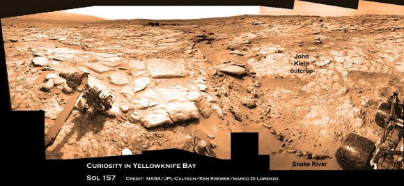
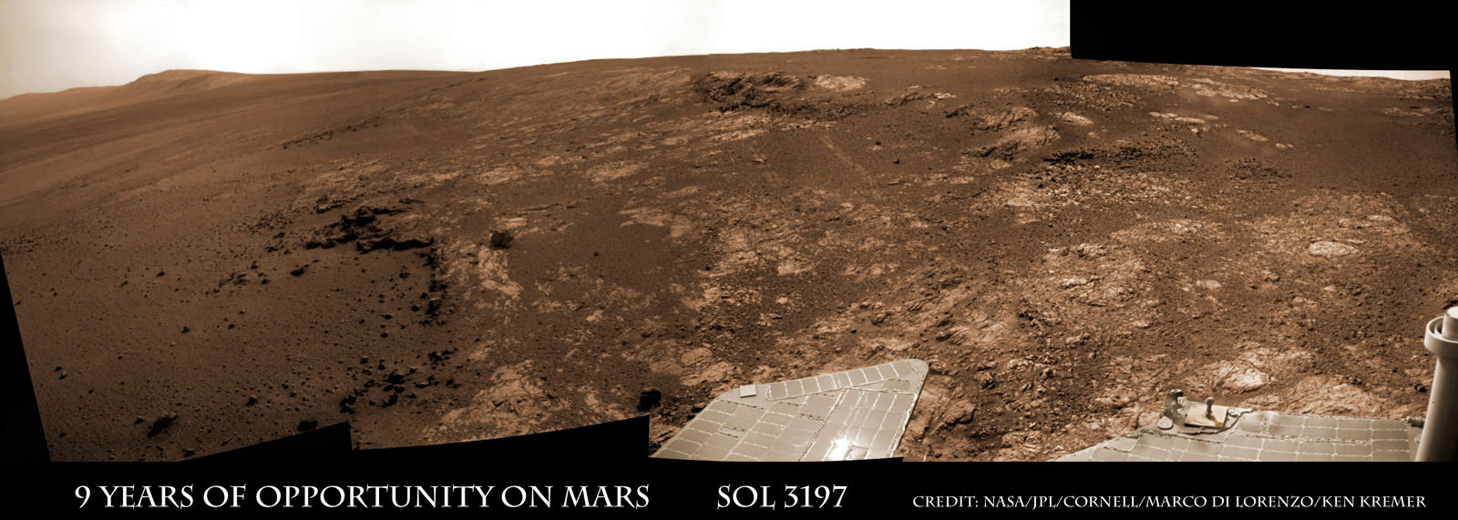
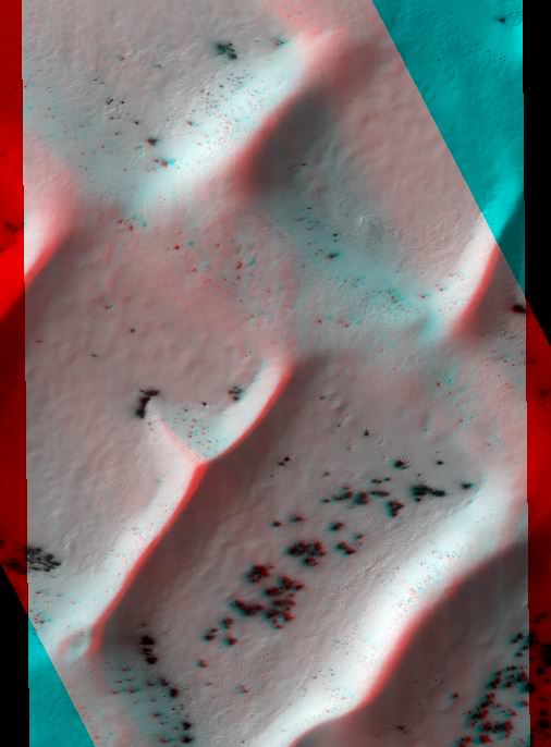
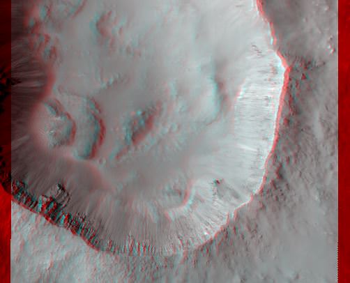
Image caption: Opportunity Celebrates 9 Years and 3200 Sols on Mars snapping this panoramic view from her current location on ‘Matijevic Hill’ at Endeavour Crater. The rover discovered phyllosilicate clay minerals and calcium sulfate veins at the bright outcrops of ‘Whitewater Lake’, at right, imaged by the Navcam camera on Sol 3197 (Jan. 20, 2013). “Copper Cliff” is the dark outcrop, at top center. Darker “Kirkwood” outcrop, at left, is site of mysterious “newberries” concretions. Credit: NASA/JPL-Caltech/Cornell/Marco Di Lorenzo/Ken Kremer

9 Years ago, NASA’s pair of identical twin sister rovers – christened Spirit & Opportunity- bounced to daunting airbag-cushioned landings on opposite sides of the Red Planet for what was supposed to be merely 90 day missions, or maybe a little bit longer scientists hoped.

Today, Opportunity celebrates a truly unfathomable achievement, starting Year 10 on Mars since she rolled to a bumpy stop on January 24, 2004 inside tiny Eagle crater. And she’s now at a super sweet spot for science (see our photo mosaic above) loaded with clays and veined minerals and making the most remarkable findings yet about the planets watery past – thus building upon a long string of previously unthinkable discoveries due to her totally unforeseen longevity.

“Regarding achieving nine years, I never thought we’d achieve nine months!” Principal Investigator Prof. Steve Squyres of Cornell University told Universe Today for this article commemorating Opportunity’s 9th anniversary.

Opportunity reached 3200 Sols, or Martian days, and counting , by her 9th birthday. She is now 108 months into the 3 month primary mission – that’s 36 times longer than the 3 month “warranty.”

“Every sol is a gift,” Squyres told me. He always refers to the rovers as our “Priceless assets on Mars”, that have to be taken good care of to wring out the maximum science data possible and for as long as humanly, or more aptly, robotically possible.

PIA16703_Sol3137B_Matijevic_Pan_L257atc_br2

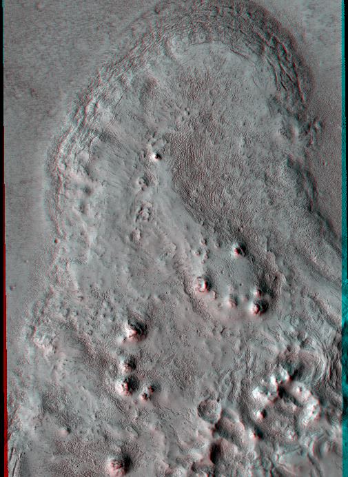
Image Caption: ‘Matijevic Hill’ Panorama for Rover’s Ninth Anniversary. As Opportunity neared the ninth anniversary of its landing on Mars, the rover was working in the ‘Matijevic Hill’ area seen in this view from Opportunity’s panoramic camera (Pancam). Two of the features investigated at Matijevic Hill are “Copper Cliff,” the dark outcrop in the left center of the image, and “Whitewater Lake,” the bright outcrop on the far right. The component images for this mosaic were taken from Sol 3137 (Nov. 19, 2012) through Sol 3150 (Dec. 3, 2012). Credit: NASA/JPL-Caltech/Cornell/Arizona State Univ.

The resilient, solar powered Opportunity robot begins her 10th year roving around beautifully Earth-like Martian terrain where where she proved that potentially life sustaining liquid water once flowed billions of years ago when the planet was warmer and wetter.

Opportunity is healthy and has driven over 22 miles (35 kilometers )- marking the first overland expedition on another planet. See our photo mosaics and route map by Ken Kremer and Marco Di Lorenzo.

She is now working at the inboard edge of “Cape York” – a hilly segment of the eroded rim of 14 mile (22 km) wide Endeavour Crater, featuring terrain with older rocks than previously inspected and unlike anything studied before. It’s a place no one ever dared dream of reaching prior to launch in the summer of 2003 and landing on the Meridiani Planum region of Mars.

“It’s like a whole new mission since we arrived at Cape York,” says Squyres.

Opportunity Sol 3182_3Ba_Ken Kremer

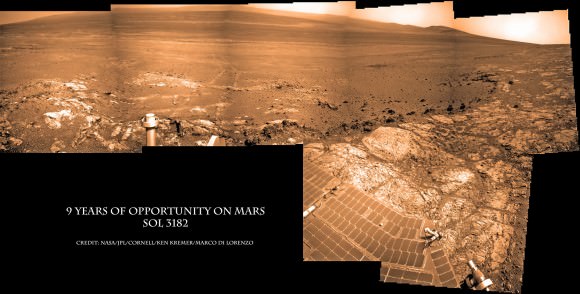
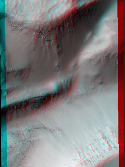
Image caption: Opportunity Celebrates 9 Years on Mars snapping this panoramic view of the vast expanse of 14 mile (22 km) wide Endeavour Crater from atop ‘Matijevic Hill’ on Sol 3182 (Jan. 5, 2013). The rover then drove 43 feet to arrive at ‘Whitewater Lake’ and investigate clay minerals. Photo mosaic was stitched from Navcam images and colorized. Credit: NASA/JPL-Caltech/Cornell/Ken Kremer/Marco Di Lorenzo

Today Opportunity is poised for breakthrough science at deposits of phyllosilicates – clay minerals which stem from an earlier epoch when liquid water flowed on Mars eons ago and perhaps may have been more favorable to sustaining microbial life because they form in more neutral pH water. Endeavour Crater is more than 3 Billion years old.

I asked Squyres to discuss the discovery of the phyllosilicates – which have never before been analyzed up close on the Martian surface and are actually a main target of NASA’s new Curiosity rover at Gale Crater.

“We have found the phyllosilicates at Cape York: they’re in the Whitewater Lake materials,” Squyres explained. Spectral data collected from Mars orbit by the CRISM spectrometer aboard NASA’s MRO circling spacecraft allowed the researchers to direct Opportunity to this exact spot.

“Whitewater Lake” is an area of bright local outcrops currently being investigated and providing information about a different and apparently less acidic environment compared to other areas and craters visited earlier in the mission – and potentially more conducive to life.

Opportunity also discovered more mineral veins at “Whitewater Lake”, in addition to those hydrated mineral veins discovered earlier at Cape York at a spot named “Homestake” – see our mosaic below.

“We have investigated the veins in these materials, and we have determined that they are calcium sulfate,” Squyres confirmed to me.

Opportunity Sol 2761_2a_Ken Kremer

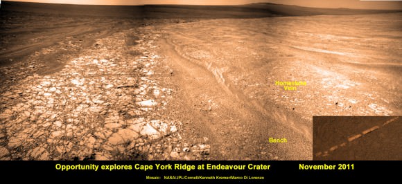
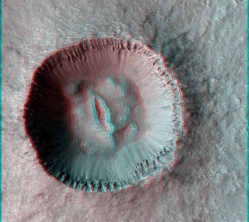
Image caption: Opportunity discovers hydrated Mineral Vein at Endeavour Crater – November 2011. Opportunity determined that the ‘Homestake’ mineral vein was composed of calcium sulfate,or gypsum, while exploring around the base of Cape York ridge at the western rim of Endeavour Crater. The vein discovery indicates the ancient flow of liquid water at this spot on Mars. This panoramic mosaic of images was taken on Sol 2761, November 2011, and illustrates the exact spot of the mineral vein discovery. Featured on NASA Astronomy Picture of the Day (APOD) on 12 Dec 2011. Credit: NASA/JPL/Cornell/Kenneth Kremer/Marco Di Lorenzo.

How do the new mineral veins compare to those at ‘Homestake’ and those just found by Curiosity at Yellowknife Bay inside Gale crater? I asked Sqyures.

“Much narrower, and possibly older,” he said compared to the Homestake calcium sulfate veins .

“It’s too early to say how they compare to the veins at Gale, though.”

The local area at “Cape York” is called “Matijevic Hill” – in honor of a recently deceased team member who played a key role on NASA’s Mars rovers.

The rover has already spent a few months at “Matijevic Hill” on a ‘walk about’ scouting survey and also found concretions dubbed “newberries” that are different from the “blueberry” concretions found earlier in the mission.

How widespread are the phyllosilicates ?

“Matijevic Hill is the only exposure of phyllosilicates we know of at Cape York, so in order to find more we’re going to have to go elsewhere,” Squyres replied. “We haven’t figured out what the “newberries” are yet, but attempting to do that will be our next task.”

It is likely to take many more weeks and even months to “figure out” what this all means for science.

Therefore, no one should expect the robot to move much in the near future. Since the rover made landfall at the western rim of Endeavour crater at Spirit Point in August 2011, she has been circling around Cape York ever since.

Opportunity Sol 2678c_Ken Kremer

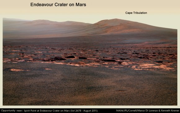
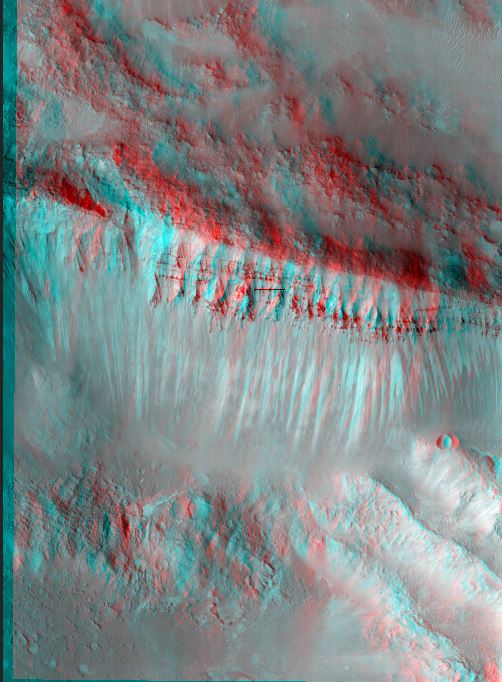
Image caption: Opportunity rover first arrived at the western rim of Endeavour Crater (14 miles, 22 km wide) in August 2011. This photo mosaic of navcam images shows portions of the segmented rim of Endeavour crater on Sol 2678. Large ejecta blocks from a smaller nearby crater are visible in the middle. At Endeavour, Opportunity will investigate the oldest minerals deposits she has ever visited from billions of years ago and which may hold clues to environments that were potentially habitable for microbial life. The rover may eventually drive to Cape Tribulation at right if she survives. Credit: NASA/JPL/Cornell/Marco Di Lorenzo/Ken Kremer (kenkremer.com)

What is the next destination for Opportunity?

“Once we’re done at Cape York, our next destination will be Solander Point [to the south],” Squyres confirmed. It’s the next rim segment south of Cape York (see map).

Eventually, if Opportunity continues to function and survives the next Martian winter, she may be directed several miles even further south, along the crater rim to a spot called Cape Tribulation – because it also harbors caches of phyllosilicate clay minerals. But there is no telling when that might be.

“One step at a time,” said Squyres as always. He is not making any guesses or predictions. The mission is totally discovery driven.

Well after so many great science discoveries over the past 9 years, I asked Squyres to describe the context and significance of the phyllosilicates discovery?

“Impossible to say, I’m afraid… we’re still figuring this place out; I can’t put it in context yet,” Squyres concluded.

Thus, there is still so much more bountiful science research still to be done by Opportunity – and nobody is making any forecasts on how long she might yet survive.

So just keep praying to the Martian weather gods for occasional winds and “dust devils” to clean off those life giving solar panels – and to the US Congress to provide the essential funding.

Ken Kremer

Opportunity Sol 2852a_Ken Kremer

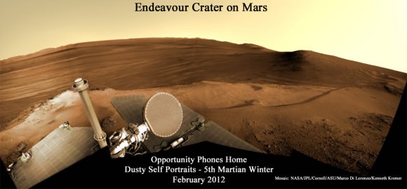
Image caption: Opportunity Phones Home – Dusty Self Portrait from Endeavour Crater on Mars on Sol 2852, February 2012. NASA’s rover Opportunity snaps self-portrait where she endured 5th frigid Martian winter at Greeley Haven. Opportunity is currently investigating Cape York ridge and Matijevic Hill at right. Vast expanse of Endeavour Crater and rim in background with dusty solar panels and full on view of the High Gain Antenna (HGA) in the foreground. Mosaic: NASA/JPL/Cornell/ASU/Marco Di Lorenzo/Ken Kremer

Opportunity Sol 2681a_annotated_Ken Kremer

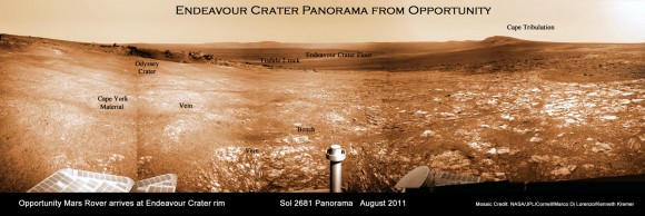
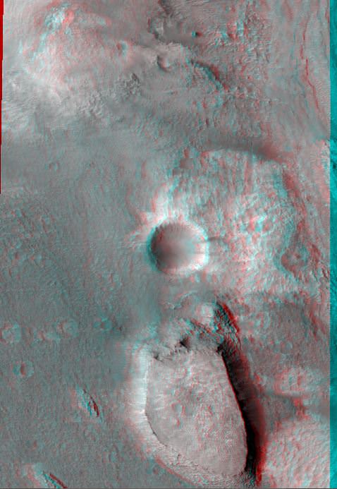
Image caption: Endeavour Crater Panorama from Opportunity, Sol 2681, August 2011 on arrival at the rim of Endeavour and Cape York ridge. Odyssey crater visible at left. Mineral veins were later found to surround Cape York. Credit: NASA/JPL/Cornell/Marco Di Lorenzo/Ken Kremer

Opportunity Route map_3187s_Ken Kremer

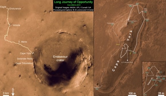
Image caption: Traverse Map for NASA’s Opportunity rover from 2004 to 2013 – shows the entire path the rover has driven over 9 years, 3200 Sols and more than 22 miles (35 km) from Eagle Crater landing site to current location at Cape York ridge at Endeavour Crater. Credit: NASA/JPL/Cornell/ASU/Marco Di Lorenzo/Ken Kremer (kenkremer.com)

Weekly Space Hangout – January 25, 2013

Back by popular demand… the Weekly Space Hangout has returned. This is a weekly broadcast on Google+, where I’m joined by a wide and varied team of space and astronomy journalists to discuss the big breaking stories this week.

This week, we talked about:

We record the Weekly Space Hangout every Friday on Google+ at 12:00 pm PST / 3:00 pm EST / 2000 GMT. You’ll want to circle Cosmoquest on Google+ to find out when we’re recording next. The audio for the Weekly Space Hangout is also released to the Astronomy Cast podcast feed.