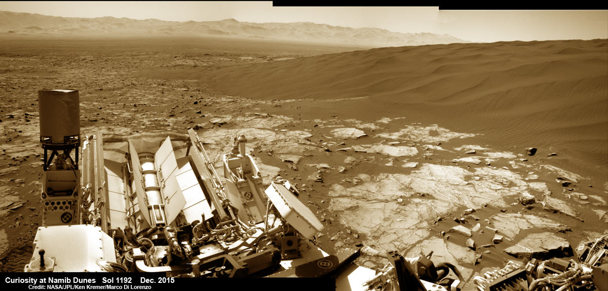
Curiosity explores Namib Dunes at base of Mount Sharp, for first in-place study of an active sand dune anywhere other than Earth. See Gale Crater rim in the distance.This colorized photo mosaic is stitched from navcam camera raw images taken on Sol 1192, Dec. 13, 2015. Credit: NASA/JPL/Ken Kremer/kenkremer.com/Marco Di Lorenzo
Curiosity’s View on Mars Today
Curiosity explores Namib Dunes at base of Mount Sharp, for first in-place study of an active sand dune anywhere other than Earth. See Gale Crater rim in the distance.This colorized photo mosaic is stitched from navcam camera raw images taken on Sol 1192, Dec. 13, 2015. Credit: NASA/JPL/Ken Kremer/kenkremer.com/Marco Di Lorenzo
After many months of painstaking driving, NASA’s Curiosity Mars rover has reached the edge of a massive field of spectacular rippled sand dunes located at the base of Mount Sharp that range up to two stories tall. And she has now begun humanity’s first up-close investigation of currently active sand dunes anywhere beyond Earth.
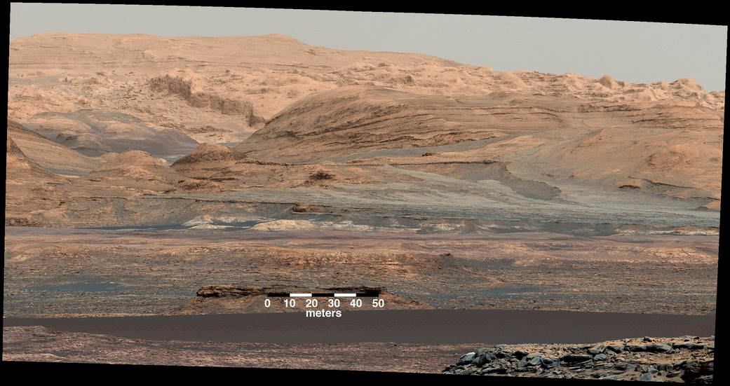
The dark band in the lower portion of this Martian scene is part of the "Bagnold Dunes" dune field lining the northwestern edge of Mount Sharp. The view combines multiple images taken with the Mast Camera on Curiosity on Sept. 25, 2015, Sol 1115th. The images are from Mastcam's right-eye camera, which has a telephoto lens. The view is toward south-southeast. The scene is white balanced. Credits: NASA/JPL-Caltech/MSSS
NASA’s Curiosity rover is on the Martian road to soon start the first ever study of currently active sand dunes anywhere beyond Earth. The dunes are located nearby, at the foothills of Mount Sharp, and Curiosity is due to arrive for an up close look in just a few days to start her unique research investigations.
The eerily dark dunes, named the “Bagnold Dunes,” skirt the northwestern flank of Mount Sharp. Ascending and diligently exploring the sedimentary layers of Mount Sharp is the primary goal of the mission.
“The ‘Bagnold Dunes’ are tantalizingly close,” says Ken Herkenhoff, Research Geologist at the USGS Astrogeology Science Center and an MSL science team member, in a mission update on Wednesday, Nov. 18.
The “Bagnold Dunes” have been quite noticeable in numerous striking images taken from Marsorbit, during the vehicles nail biting ‘7 Minutes of Terror’ descent from orbit, as well as in thousands upon thousands of images taken by Curiosity herself as the robot edged ever closer during her over three year long traverse across the floor of the Gale Crater landing site.
Curiosity must safely cross the expansive dune field before climbing Mount Sharp.
Although multiple NASA rovers, including Curiosity, have studied much smaller Martian sand ripples or drifts, none has ever visited and investigated up close these types of large dunes that range in size as tall as a two story building or more and as wide as a football field or more.
Moreover the Martian dunes are shifting even today.
“Shifting sands lie before me,” Curiosity tweeted. “Off to image, scoop and scuff active dunes on Mars. I’ll be the first craft to visit such dunes beyond Earth!”
Mount Sharp and dark Bagnold Dunes
Curiosity rover panorama of Mount Sharp captured on June 6, 2014 (Sol 651) during traverse inside Gale Crater. Note rover wheel tracks at left. She will eventually ascend the mountain at the ‘Murray Buttes’ at right later this year. Assembled from Mastcam color camera raw images and stitched by Marco Di Lorenzo and Ken Kremer. Credit: NASA/JPL/MSSS/Marco Di Lorenzo/Ken Kremer-kenkremer.com
“The Bagnold Dunes are active: Images from orbit indicate some of them are migrating as much as about 3 feet (1 meter) per Earth year. No active dunes have been visited anywhere in the solar system besides Earth,” notes NASA.
Curiosity is currently only some 200 yards or meters away from the first dune she will investigate, simply named “Dune 1.”
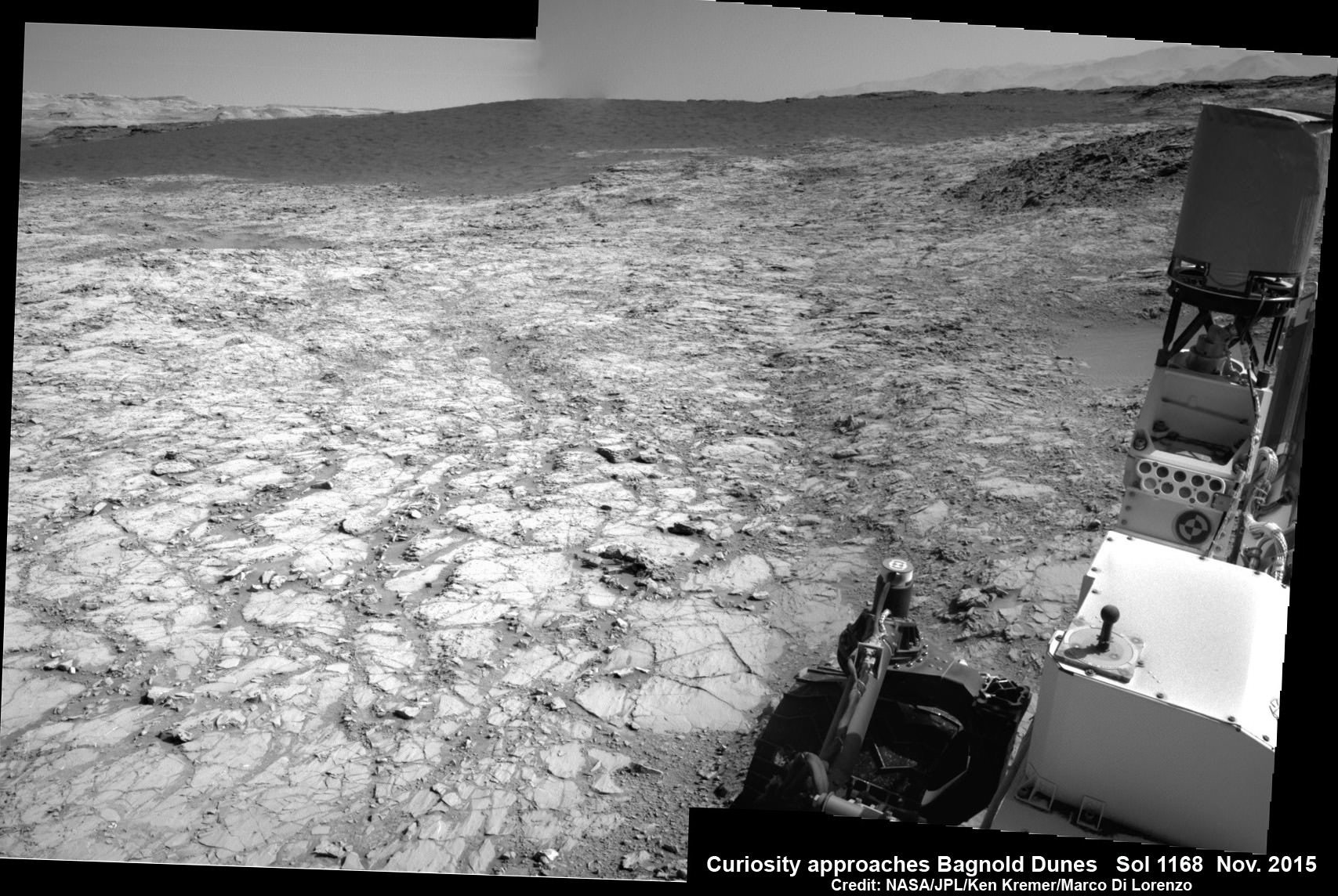
Curiosity approaches the dark Bagnold Dunes for first in-place study of an active sand dune anywhere other than Earth. This photo mosaic is stitched from navcam camera raw images taken on Sol 1168, Nov. 18, 2015. Credit: NASA/JPL/Ken Kremer/kenkremer.com/Marco Di Lorenzo
As the rover approaches closer and closer, the dune research campaign is already in progress as she snaps daily high resolution images and gathers measurements of the area’s wind direction and speed.
“We’ve planned investigations that will not only tell us about modern dune activity on Mars but will also help us interpret the composition of sandstone layers made from dunes that turned into rock long ago,” said Bethany Ehlmann of the California Institute of Technology and NASA’s Jet Propulsion Laboratory, in Pasadena, California, in a statement.
After arriving at the dune, the team will command Curiosity to scoop up samples for analysis by the rover’s pair of miniaturized chemistry instruments inside its belly. It will also scuff the dune with a wheel to examine and compare the surface and interior physical characteristics.
This Sept. 25, 2015, view from the Mast Camera on NASA’s Curiosity Mars rover shows a dark sand dune in the middle distance. The rover’s examination of dunes on the way toward higher layers of Mount Sharp will be the first in-place study of an active sand dune anywhere other than Earth. Credits: NASA/JPL-Caltech/MSSS
The dark dunes are informally named after British military engineer Ralph Bagnold (1896-1990), who conducted pioneering studies of the effect of wind on motion of individual particles in dunes on Earth. Curiosity will carry out “the first in-place study of dune activity on a planet with lower gravity and less atmosphere.”
Although the huge Bagnold dunes are of great scientific interest, the team will also certainly exercise caution in maneuvering the car sized six wheel robot.
Recall that NASA’s smaller golf cart Spirit Mars rover perished a few years back – albeit over 6 years into her 3 month mission – when the robot became unexpectedly mired in a nearly invisible sand ripple from which she was unable to escape.
Likewise, sister Opportunity got stuck in a sand ripple earlier in her mission that took the engineering team weeks of painstaking effort to extricate from a spot subsequently named ‘Purgatory’ that resulted in many lessons learned for future operations.
Opportunity is still hard at work – currently exploring Marathon Valley – nearly a dozen years into her planned 3 month mission.
Based on orbital observations by the CRISM and HiRISE instruments aboard NASA’s Mars Reconnaissance Orbiter, the science team has concluded that the Bagnold Dunes are mobile and also have an uneven distribution of minerals, such as olivine.
“We will use Curiosity to learn whether the wind is actually sorting the minerals in the dunes by how the wind transports particles of different grain size,” Ehlmann said.
“If the Bagnold campaign finds that other mineral grains are sorted away from heavier olivine-rich grains by the wind’s effects on dune sands, that could help researchers evaluate to what extent low and high amounts of olivine in some ancient sandstones could be caused by wind-sorting rather than differences in alteration by water,” say researchers.
“These dunes have a different texture from dunes on Earth,” said team member Nathan Bridges, of the Johns Hopkins University’s Applied Physics Laboratory, Laurel, Maryland.
“The ripples on them are much larger than ripples on top of dunes on Earth, and we don’t know why. We have models based on the lower air pressure. It takes a higher wind speed to get a particle moving. But now we’ll have the first opportunity to make detailed observations.”
Last month Curiosity conducted her eighth drill campaign for sample chemical analysis at the ‘Big Sky’ site, before moving on to ‘Greenhorn’. Big Sky was an area of cross-bedded sandstone rock in the Stimson geological unit on the lower slopes of Mount Sharp.
NASA Curiosity rover reaches out with robotic arm to drill into cross-bedded sandstone rock at ‘Big Sky’ target on Sol 1119, Sept. 29, 2015, in this photo mosaic stitched from navcam camera raw images and colorized. Big Sky is located in the Stimson unit on the lower slopes of Mount Sharp inside Gale Crater. Credit: NASA/JPL/Ken Kremer/kenkremer.com/Marco Di Lorenzo
Curiosity has already accomplished her primary objective of discovering a habitable zone on the Red Planet – at the Yellowknife Bay area – that contains the minerals necessary to support microbial life in the ancient past when Mars was far wetter and warmer billions of years ago.
As of today, Sol 1168, November 19, 2015, she has driven over 6.9 miles (11.1 kilometers) kilometers and taken over 282,100 amazing images.
Stay tuned here for Ken’s continuing Earth and planetary science and human spaceflight news.
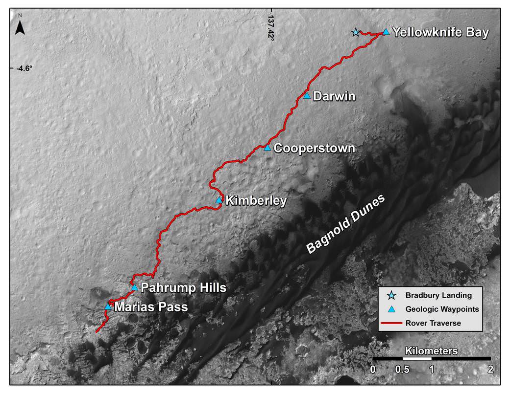
This map shows the route driven by NASA’s Curiosity Mars rover from the location where it landed in August 2012 to its location in mid-November 2015 through Sol 1165, approaching examples of dunes in the “Bagnold Dunes” dune field. Credits: NASA/JPL-Caltech/Univ. of Arizona
………….
Learn more about Orbital ATK Cygnus, ISS, ULA Atlas rocket, SpaceX, Boeing, Space Taxis, Mars rovers, Orion, SLS, Antares, NASA missions and more at Ken’s upcoming outreach events:
Dec 1 to 3: “Orbital ATK Atlas/Cygnus launch to the ISS, ULA, SpaceX, SLS, Orion, Commercial crew, Curiosity explores Mars, Pluto and more,” Kennedy Space Center Quality Inn, Titusville, FL, evenings
Dec 8: “America’s Human Path Back to Space and Mars with Orion, Starliner and Dragon.” Amateur Astronomers Assoc of Princeton, AAAP, Princeton University, Ivy Lane, Astrophysics Dept, Princeton, NJ; 7:30 PM.
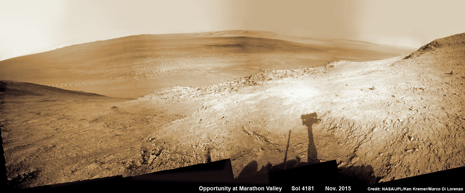
NASA’s Opportunity rover peers outwards across to the vast expense of Endeavour Crater from current location descending along steep walled Marathon Valley in early November 2015. Marathon Valley holds significant deposits of water altered clay minerals holding clues to the planets watery past. Shadow of Pancam Mast assembly and robots deck visible at right. This navcam camera photo mosaic was assembled from images taken on Sol 4181 (Oct. 29, 2015) and colorized. Credit: NASA/JPL/Cornell/Ken Kremer/kenkremer.com/Marco Di Lorenzo
NASA’s Opportunity rover peers outwards across to the vast expense of Endeavour Crater from current location descending along steep walled Marathon Valley in early November 2015. Marathon Valley holds significant deposits of water altered clay minerals holding clues to the planets watery past. Shadow of Pancam Mast assembly and robots deck visible at right. This navcam camera photo mosaic was assembled from images taken on Sol 4181 (Oct. 29, 2015) and colorized. Credit: NASA/JPL/Cornell/Ken Kremer/kenkremer.com/Marco Di Lorenzo
Just shy of an unfathomable 4200 Sols traversing ravishing alien terrain on the Red Planet, the longest living ‘Martian’ – NASA’s robot ‘Opportunity’ – is driving between “lily pads” down steep walled Marathon Valley in search of life giving sun that enables spectacular science yielding clues to Marswatery past. All this as she strives to survive utterly harsh climate extremes, because ‘winter is coming’ for her seventh time on the fourth rock from the sun!
“Opportunity is driving east and southeast down Marathon Valley, bisecting the region in which we detect smectites [clay minerals] using CRISM [spectrometer] data,” Opportunity Deputy Principal Investigator Ray Arvidson, of Washington University in St. Louis, told Universe Today.
Artist’s rendering of a solar storm hitting Mars and stripping ions from the planet's upper atmosphere. Credits: NASA/GSFC
NASA’s Mars Atmosphere and Volatile Evolution (MAVEN) orbiter mission has determined that ancient Mars suffered drastic climate change and lost its thick atmosphere and surface bodies of potentially life giving liquid water because it lost tremendous quantities of gas to space via stripping by the solar wind, based on new findings that were announced today, Nov. 5, at a NASA media briefing and in a series of scientific publications.
The process of Mars dramatic transformation from a more Earth-like world to its barren state today started about 4.2 Billion years ago as the shielding effect of the global magnetic field was lost as the planets internal dynamo cooled, Bruce Jakosky, MAVEN principal investigator at the Laboratory for Atmospheric and Space Physics (LASP) at the University of Colorado, Boulder, told Universe Today.
The radical transformation of ancient Mars from a warm world with significant bodies of standing water that could have supported life, to its current state as a cold, arid and desert-like world that’s rather inhospitable to life was caused by the loss of most the planet’s atmosphere as powerful streams of solar wind particles crashed into it and stripped it away due to the loss of the protective magnetic field as the planets core cooled.
“We think that the early magnetic field that Mars had would have protected the planet from direct impact by the solar wind and would have kept it from stripping gas off,” Jakosky told me.
“So it would have been the turn off of the magnetic field, that would have allowed the turn on of stripping of the atmosphere by the solar wind.”
“The evidence suggests that the magnetic field disappeared about 4.2 Billion years ago.”
The period of abundant surface water actively carving the Martian geology lasted until about 3.7 Billion years ago. The loss of the atmosphere by stripping of the solar wind took place from about 4.2 to 3.7 Billion years ago.
Billions of years ago, Mars was a very different world. Liquid water flowed in long rivers that emptied into lakes and shallow seas. A thick atmosphere blanketed the planet and kept it warm. Credit: NASA
With the release of today’s results, the MAVEN science team has accomplished the primary goal of the mission, which was to determine how and why Mars lost its early, thick atmosphere and water over the past four billion years. The atmosphere is composed mostly of carbon dioxide.
Since water is a prerequisite for life as we know it, determining its fate and longevity on Mars is crucial for determining the habitability of the Red Planet and its potential for supporting martian microbes, past of present if they ever existed.
“The NASA Mars exploration program has been focused on finding water,” said Michael Meyer, lead scientist for the Mars Exploration Program at NASA Headquarters.
“Water is the prime ingredient needed for life. It is a major factor in the climate and for shaping geology. And it is a critical resource for future human exploration.”
This NASA video shows a visualization of the solar wind striking Mars:
Video caption: Created using data from NASA’s Mars Atmosphere and Volatile Evolution (MAVEN) mission, this visualization shows how the solar wind strips ions from the Mars’ upper atmosphere into space. Credits: NASA-GSFC/CU Boulder LASP/University of Iowa
MAVEN arrived in orbit at Mars just over one year ago on Sept. 21, 2014.
The $671 Million MAVEN spacecraft’s goal is to study Mars tenuous upper atmosphere in detail for the very first time by any spacecraft and to explore the mechanisms of how the planet lost its atmosphere and life giving water over billions of years as well as determine the rate of atmospheric loss.
The new MAVEN data have enabled researchers to measure the rate of Mars atmospheric loss of gas to space via the action of solar wind stripping as well as the erosional effect of solar storms.
Based on measurements from MAVEN’s suite of nine state-of-the-art scientific instruments, the solar wind is stripping away gas at a rate of about 100 grams (equivalent to roughly 1/4 pound) every second today, in the form of carbon dioxide and oxygen, said David Brain, MAVEN co-investigator at LASP.
“Most of the stripping [of the Martian atmosphere] by the solar wind at Mars was thought to have taken place very early in the history of the solar system when the sun was much more active and when the solar wind was more intense. So today the rate of loss at Mars is low,” Jakosky said at the briefing.
“Today’s Mars is a cold dry desert-like environment. The atmosphere is thin and it’s not capable of sustaining liquid water at the surface today, it would freeze or evaporate very quickly. However when we look at ancient Mars we see a different type of surface, one that had valleys that looked like they were carved by water and lakes that were standing for long periods of time. We see an environment that was much more able to support liquid water.”
The MAVEN results were published today in nearly four dozen scientific papers in the Nov. 5 issues of the journals Science and Geophysical Research Letters.
I asked Jakosky; How much gas would have been lost from ancient Mars and what is the rough estimate for the ancient rate of loss to arrive at Mars thin atmosphere today?
“For the amount of gas that we think you would have to have been removed – let me start with the current Mars atmosphere which has a thickness of 6 millibars, that’s just under 1% as thick as the Earth’s atmosphere,” Jakosky replied.
“So we think you would have to remove an amount of gas that is about equivalent to what’s in Earth’s atmosphere today.”
“So the rate would have to have been a factor of about 100 to 1000 times higher, than today’s loss of 100 grams per second in order to have removed the gas early in that time period, which is consistent with what the models have predicted that the loss rate would have been back then in early history.”
NASA’s Mars Atmosphere and Volatile EvolutioN (MAVEN) spacecraft celebrated one Earth year in orbit around Mars on Sept. 21, 2015. MAVEN was launched to Mars on Nov. 18, 2013 from Cape Canaveral Air Force Station in Florida and successfully entered Mars’ orbit on Sept. 21, 2014. Credit: NASA
What is the solar wind and how does it strip away the atmosphere?
“The solar wind is a stream of particles, mainly protons and electrons, flowing from the sun’s atmosphere at a speed of about one million miles per hour. The magnetic field carried by the solar wind as it flows past Mars can generate an electric field, much as a turbine on Earth can be used to generate electricity. This electric field accelerates electrically charged gas atoms, called ions, in Mars’ upper atmosphere and shoots them into space,” according to a NASA description.
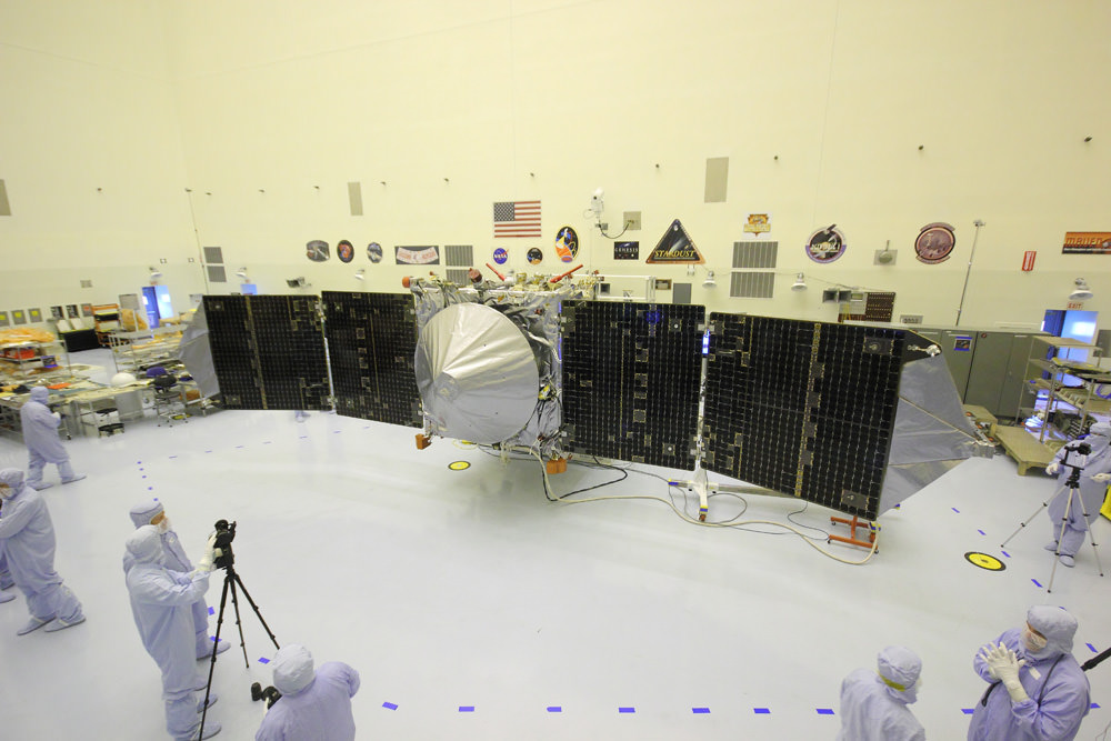
MAVEN is NASA’s next Mars orbiter and is due to blastoff on Nov. 18 from Cape Canaveral, Florida. It will study the evolution of the Red Planet’s atmosphere and climate. Universe Today visited MAVEN inside the clean room at the Kennedy Space Center. With solar panels unfurled, this is exactly how MAVEN looks when flying through space and circling Mars. Credit: Ken Kremer/kenkremer.com
MAVEN is just now completing its primary mission and starts the extended mission phase on Nov. 16.
The 5,400 pound MAVEN probe carries nine sensors in three instrument suites to study why and exactly when did Mars undergo the radical climatic transformation.
MAVEN’s observations will be tied in with NASA’s ongoing Curiosity and Opportunity surface roving missions as well as MRO and Mars Odyssey to provide the most complete picture of the fourth rock from the sun that humanity has ever had.
MAVEN thundered to space on Nov. 18, 2013 following a flawless blastoff from Cape Canaveral Air Force Station’s Space Launch Complex 41 atop a powerful United Launch Alliance Atlas V rocket.
Stay tuned here for Ken’s continuing Earth and planetary science and human spaceflight news.
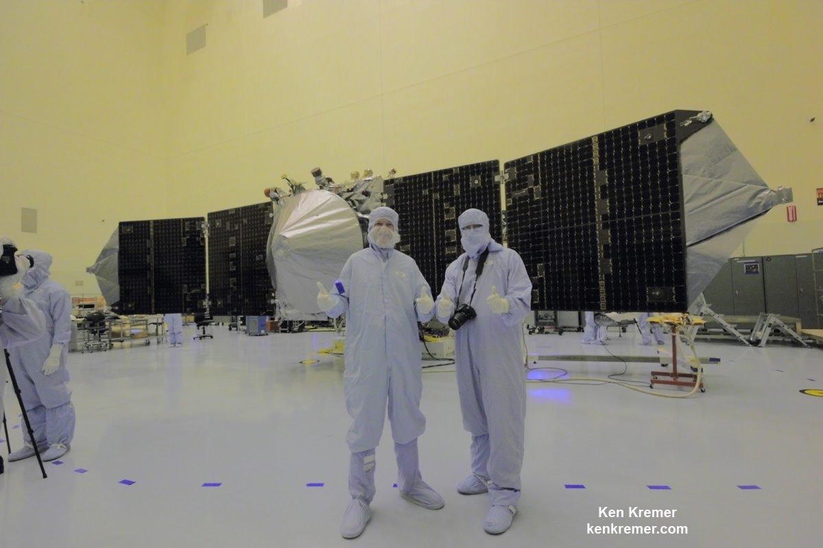
NASA’s MAVEN Mars orbiter, chief scientist Prof. Bruce Jakosky of CU-Boulder and Ken Kremer of Universe Today inside the clean room at the Kennedy Space Center on Sept. 27, 2013. MAVEN launched to Mars on Nov. 18, 2013 from Florida. Credit: Ken Kremer/kenkremer.com
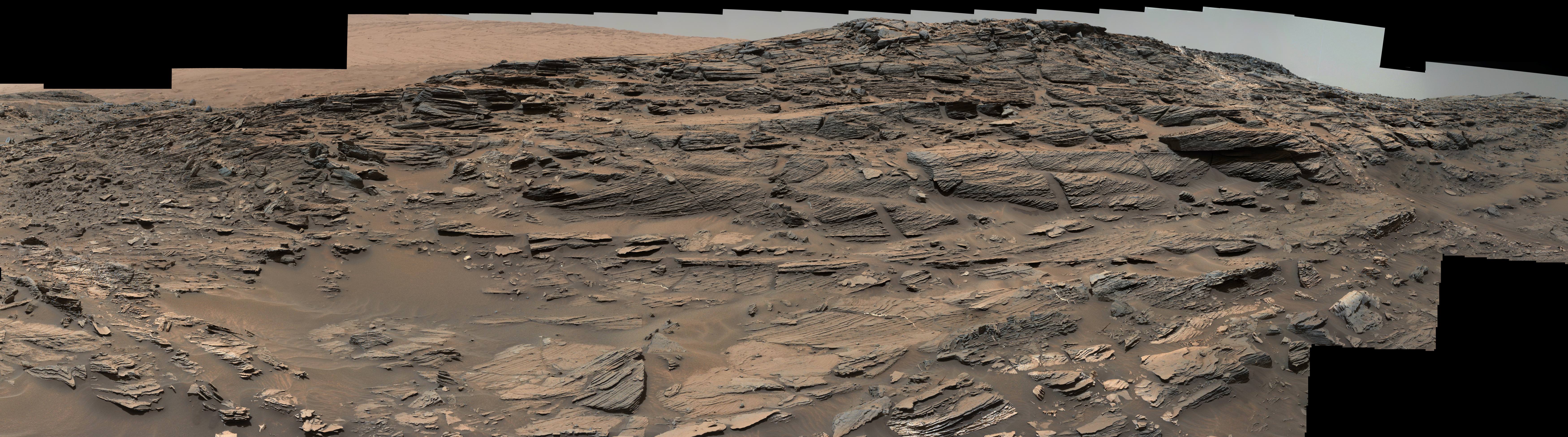
Large-scale crossbedding in the sandstone of this ridge on a lower slope of Mars' Mount Sharp is typical of windblown sand dunes that have petrified. NASA's Curiosity Mars rover used its Mastcam to capture this vista on Aug. 27, 2015, Sol 1087. Similarly textured sandstone is common in the U.S. Southwest. Credits: NASA/JPL-Caltech/MSSS
Large-scale crossbedding in the sandstone of this ridge on a lower slope of Mars’ Mount Sharp is typical of windblown sand dunes that have petrified. NASA’s Curiosity Mars rover used its Mastcam to capture this vista on Aug. 27, 2015, Sol 1087. Similarly textured sandstone is common in the U.S. Southwest. Credits: NASA/JPL-Caltech/MSSS
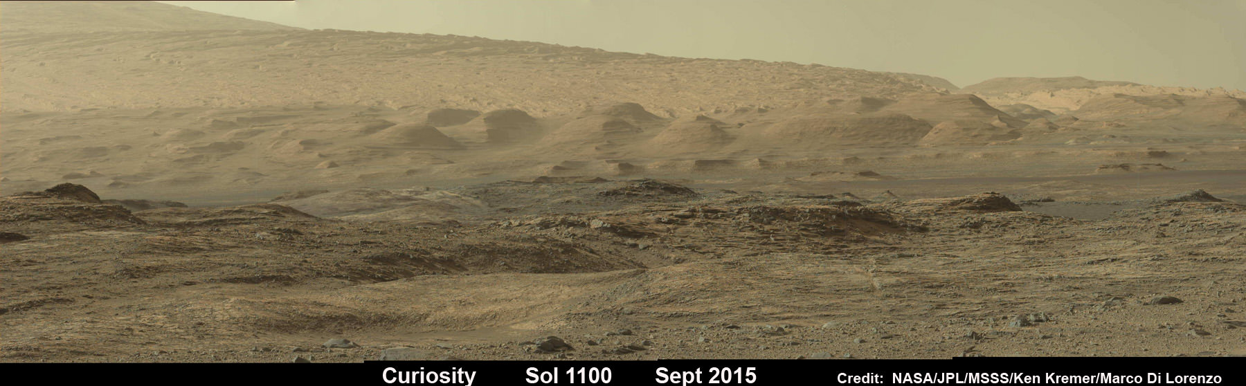
See Sol 1100 mosaic below [/caption]
NASA’s SUV-sized Curiosity rover has arrived at a beautiful Martian vista displaying a huge deposit of magnificently petrified sand dunes that look remarkably like some commonly found on Earth and native to the deserts of the U.S. Southwest.
The petrified sand dunes were discovered amongst an area of dark sandstone along a ridge at the lower slope of Mars’ Mount Sharp. They are now being explored in detail by the six wheeled rover in a geologic feature dubbed the Stimson unit.
“The team is considering where to drill next within the Stimson sandstone and we are looking for the best light toned areas to check for mineralogical signs of water-rock reaction,” says John Bridges, rover team member from the University of Leicester, England, in the latest mission update from today, September 12, 2015.
Curiosity looks toward fabulous canyons and buttes at the base of Mount Sharp from the Stimson sand dunes on Mars on Sol 1100, Sept. 10 2015 in this photo mosaic stitched from Mastcam color camera raw images. Credit: NASA/JPL/MSSS/Ken Kremer/kenkremer.com/Marco Di Lorenzo
Curiosity also discovered large-scale crossbedding in the sandstone that were formed by the action of Martian winds.
“This sandstone outcrop — part of a geological layer that Curiosity’s science team calls the Stimson unit — has a structure called crossbedding on a large scale that the team has interpreted as deposits of sand dunes formed by wind,” according to the rover team.
So Curiosity was commanded by her handlers back on Earth to capture an array of high resolution imagery as part of detailed investigation of the area for up close and contact science.
Dozens of images were taken with the pair of high resolution Mastcam color cameras on the robots mast and combined into the panoramic scene show above and another shown below with a scalebar the length of a tall human, 6.6 feet or 200 centimeters.
Large-scale crossbedding in the sandstone of this ridge on a lower slope of Mars’ Mount Sharp is typical of windblown sand dunes that have petrified. NASA’s Curiosity Mars rover used its Mastcam to capture this vista on Aug. 27, 2015. Similarly textured sandstone is common in the U.S. Southwest. Credits: NASA/JPL-Caltech/MSSS
The images were taken on Aug. 27, 2015, corresponding to Sol 1087 of the rover’s work on Mars, using both the 34 millimeter-focal-length lens and the 100 mm millimeter-focal-length telephoto Mastcam camera lenses that function as Curiosity’s left and right eyes.
The panorama spans the Martian terrain looking from the east, at left, to the south-southwest at right.
“Some of the dark sandstone in the area …. shows texture and inclined bedding structures characteristic of deposits that formed as sand dunes, then were cemented into rock” say officials.
“Sets of bedding laminations lie at angles to each other.”
Since taking the panorama in late August, the team has driven Curiosity around the area to collect more measurements with her state of the art science instruments.
Later this month, Curiosity will drill into an outcrop at the Stimson unit sandstone for collection and feed it for analysis into the pair of on board chemistry labs – SAM and CheMin- located inside the rover’s belly.
Curiosity already carried out initial contact science in the area by extending the robotic arm to rock targets for investigation with the arm mounted instruments, including the MAHLI camera and APXS spectrometer.
Curiosity “investigated an outcrop of the Stimson unit … and conducted successful contact science,” says Lauren Edgar, Research Geologist at the USGS Astrogeology Science Center and an MSL science team member, in a mission update.
Scientists will select the Stimson drill target soon.
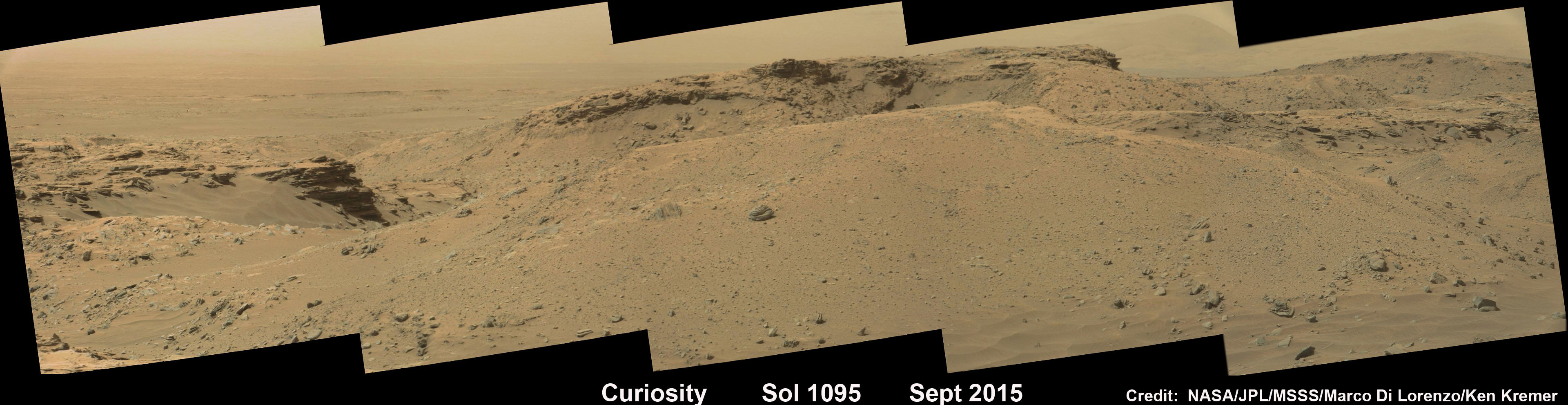
Curiosity rover explores around the Stimson unit at the base of Mount Sharp on Mars on Sol 1095, Sept. 5, 2015 in this photo mosaic stitched from Mastcam color camera raw images. Credit: NASA/JPL/MSSS/Marco Di Lorenzo/Ken Kremer/kenkremer.com
Why explore outcrops at Stimson?
“The Stimson unit overlies a layer of mudstone that was deposited in a lake environment. Curiosity has been examining successively higher and younger layers of Mount Sharp, starting with the mudstone at the mountain’s base, for evidence about changes in the area’s ancient environment.”
Curiosity’s prior drill campaign was recently conducted at the “Buckskin” outcrop target in early August 2015. Buckskin was very notable for being the first high silica rock drilling target of the mission.
Curiosity extends robotic arm and conducts sample drilling at “Buckskin” rock target at bright toned “Lion” outcrop at the base of Mount Sharp on Mars, seen at right. Gale Crater eroded rim seen in the distant background at left, in this composite multisol mosaic of navcam raw images taken to Sol 1059, July 30, 2015. Navcam camera raw images stitched and colorized. Inset: MAHLI color camera up close image of full depth drill hole at “Buckskin” rock target on Sol 1060. Credit: NASA/JPL-Caltech/MSSS/Ken Kremer/kenkremer.com/Marco Di Lorenzo
Stimson and Buckskin sit at the base of Mount Sharp, a huge layered mountain that dominates the center of the 96 mile-wide (154 kilometers-wide) Gale Crater landing site.
Exploring the sedimentary layers of Mount Sharp, which towers 3.4 miles (5.5 kilometers) into the Martian sky, is the primary destination and goal of the rovers long term scientific expedition on the Red Planet.
As of today, Sol 1102, September 12, 2015, she has driven some 6.9 miles (11.1 kilometers) kilometers and taken over 268,000 amazing images.
Curiosity has already accomplished her primary objective of discovering a habitable zone on the Red Planet – at the Yellowknife Bay area – that contains the minerals necessary to support microbial life in the ancient past when Mars was far wetter and warmer billions of years ago.
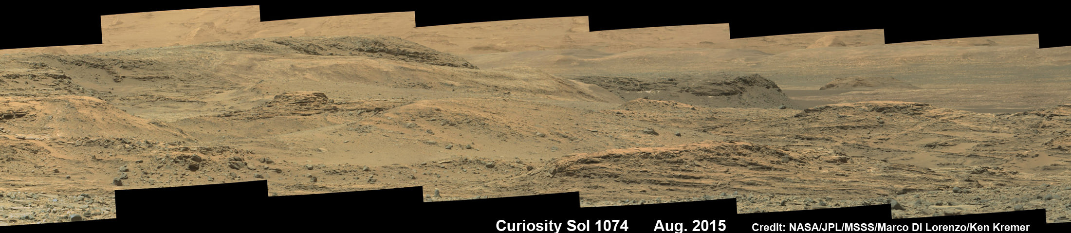
Curiosity rover scans toward south east around Marias Pass area at the base of Mount Sharp on Mars on Sol 1074, Aug. 14, 2015 in this photo mosaic stitched from Mastcam color camera raw images. Credit: NASA/JPL/MSSS/Marco Di Lorenzo/Ken Kremer/kenkremer.com
Stay tuned here for Ken’s continuing Earth and planetary science and human spaceflight news.
NASA’s Martian Curiosity rover looks backs to 1000 Sols of science and exploration on the surface of the Red Planet. Robot wheel tracks lead back through valley dunes. Gale Crater rim seen in the distant hazy background. Sol 997 (May 28, 2015) navcam camera raw images stitched and colorized. Credit: NASA/JPL-Caltech/ Marco Di Lorenzo/Ken Kremer/kenkremer.com
Featured on APOD on June 13, 2015
Looking back 1000 Sols on the Red Planet
NASA’s Martian Curiosity rover looks backs to 1000 Sols of science and exploration on the surface of the Red Planet. Robot wheel tracks lead back through valley dunes. Gale Crater rim seen in the distant hazy background. Sol 997 (May 28, 2015) navcam camera raw images stitched and colorized. Credit: NASA/JPL-Caltech/ Marco Di Lorenzo/Ken Kremer/kenkremer.com Featured on APOD on June 13, 2015
Story updated[/caption]
The Martian Curiosity celebrates 1000 Sols on Mars!
Marking the occasion with utter glee, the car sized robot snapped a cool mosaic view (above) looking back to 1000 Sols of high impact exploration and discovery on the Red Planet, showing her wheel tracks leading back through valley dunes from the foothills of humongous Mount Sharp and across the alien surface floor and out to the distant rim of the Gale Crater landing site she descended to nearly three years ago in August 2012.
“A thousand thanks to the best team a rover could have. Celebrating 1,000 sols. Here’s to the Martian days ahead!” the robot tweeted.
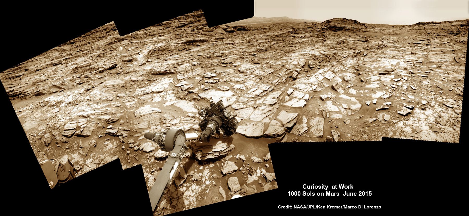
But at 1K sols she’s not content to just bask in the Martian sunshine during the history making event. Rather, she is as always hard at work, reaching out with the high tech robotic arm and inspecting intriguing rock outcrops spread out all around her.
Check out Curiosity’s current workspace, looking back and hard at work in our new photo mosaics herein created by the imaging team of Marco Di Lorenzo and Ken Kremer. They are also featured at NBC News – here – and Alive Space Images (in Italian) – here and here.
Curiosity rover at work for 1000 Sols on Mars
This composite multi sol photo mosaic shows outstretched robotic arm inspecting intriguing rock outcrops. The APXS spectrometer is investigating a target called ‘Ronan’ on the Stimson overlying outcrop. Navcam camera raw images taken from sols 997 to 1000 are stitched and colorized. Credit: NASA/JPL/Ken Kremer/kenkremer.com/Marco Di Lorenzo
The raw images for the look back mosaic were taken after she arrived at her current location on Martian Sol 997, or Earth’s Day May 28, 2015.
The Curiosity Mars Science Laboratory (MSL) rover officially celebrated 1000 Martian Sols on May 31, 2015 since she safely touched down on the crater floor on August 5, 2012 following the nail-biting and unprecedented sky crane maneuver that delivered her with pinpoint precision to a landing site nearby Mount Sharp.
“An MSL landmark day. We have reached 1000 sols on Mars. Looking back the remarkable thing is how few serious problems there have been,” says team member Professor John Bridges of the University of Leicester, England, in an update.
Exploring the sedimentary layers of Mount Sharp, which towers 3.4 miles (5.5 kilometers) into the Martian sky, form the primary destination and goal of her scientific expedition.
The six wheeled robot and her team of handlers back on Earth, are eeking out every last drop of science before she and all of Earth’s entire Martian invasion fleet enter solar conjunction, when Mars is behind the sun and little or no communications will be possible for most of the month of June. Activities will be limited per safety protocols.
“However, there is one issue even Curiosity can’t avoid – Conjunction. For much of June, Mars will be obscured from Earth by the Sun. Few science operations,” explains Bridges.
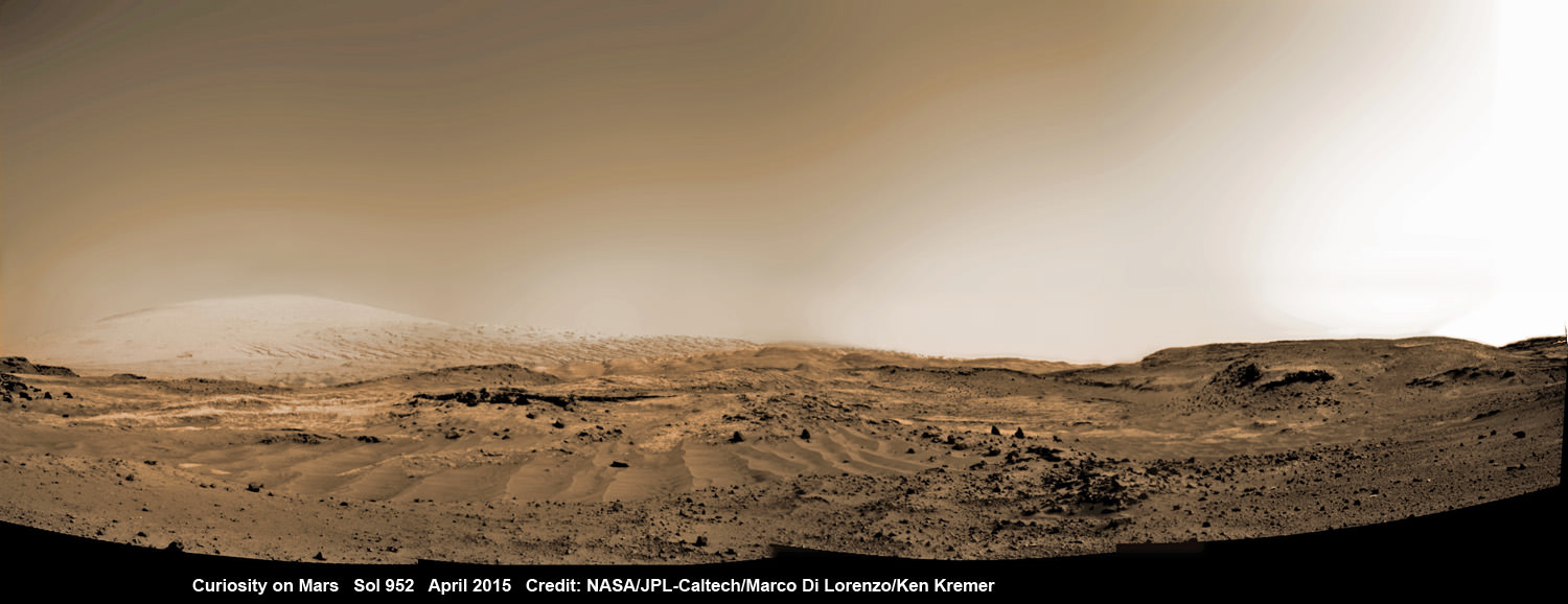
Curiosity rover rolls across Mars at the foothills of Mount Sharp, seen in the background, in this mosaic of images taken on April 11, 2015 (Sol 952). Navcam camera raw images stitched and colorized. Credit: NASA/JPL-Caltech/ Marco Di Lorenzo/Ken Kremer/kenkremer.com
After a short drive Curiosity arrived at her current location at “Marias Pass” on Sol 997, where she will stay stationary during the conjunction period out of an abundance of caution.
“A short bump on Sol 997 put Curiosity in a great position to investigate a few different rock units in Marias Pass, using the instruments on the rover’s arm,” wrote MSL and USGS mission scientist Ken Herkenhoff in an update.
She also reached within an eyelash of 10.6 kilometers (6.6 mi) of total driving.
“The 2.5 m drive brings our total odometry to 10,599 m,” noted Herkenoff.
Along the way she discovered the chemical ingredient minerals necessary to support life, as well as low levels of some organic molecules and some traces of methane, and and ample evidence for lakes and streams of liquid water.
“Curiosity is now parked for the next few weeks. But we are parked in front of a beautiful outcrop that shows the contact between the underlying Pahrump unit and the overlying Stimson unit.”
Our arm photo mosaic herein shows the seven foot (2 m) long robotic arm and its APXS spectrometer deployed at the target called “Ronan”, which is part of the overlying Stimson outcrop unit.
The rover is also using the ChemCam, MastCam and MAHLI cameras and spectrometers and other instruments to characterize the outcrop and its texture and composition in detail.
The robotic arm will be stowed during the June conjunction period.
Curiosity arrived at the Pahrump Hills at the base of Mount Sharp back in September 2014. Since then she has conducted an intensive investigation of the rocks and a trio of drilling operations to elucidate how this area fits in context with Mount Sharp and the habitable region discovered on the crater floor at Yellowknife Bay back in the spring of 2013.
In recent weeks, Curiosity has been driving up hills with slopes of as much as 21 degrees, higher than ever before, on an exciting journey endeavoring to slowly ascend up to the lower layers of Mount Sharp.
The current Martian outcrop area under investigation is a place where two distinctive geologic types of bedrock meet and where pale rock meets darker overlying rock.
“Such contacts can reveal clues about how the environmental conditions that produced one type of rock were related to the conditions that produced the other,” says NASA.
“The rover science team wants to examine an outcrop that contains the contact between the pale rock unit the mission analyzed lower on Mount Sharp and a darker, bedded rock unit that the mission has not yet examined up close.”
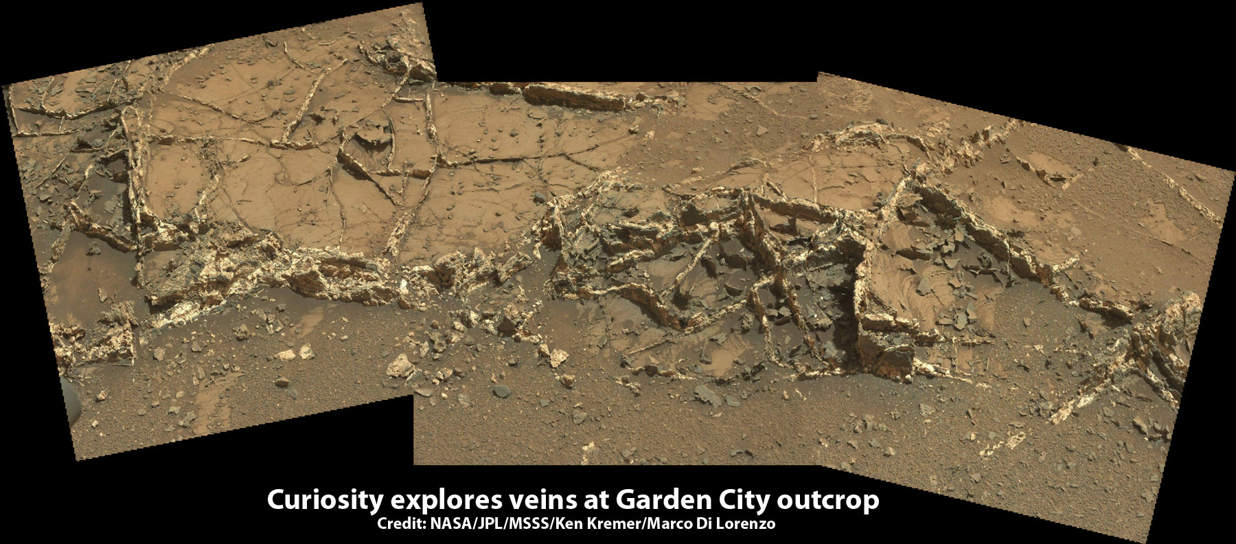
The team is also scouting around for the presence of mineral veins, like those recently discovered at the “Garden City” outcrop, that formed in the past during periods of flowing liquid water that could be favorable for microbial life forms if they ever existed.
Curiosity investigates a beautiful outcrop of scientifically enticing dark and light mineral veins at ”Garden City” outcrop at the base of Mount Sharp at current location on Mars. This photo mosaic was stitched from Mastcam color camera raw images. Credit: NASA/JPL-Caltech/MSSS/Ken Kremer/kenkremer.com/Marco Di Lorenzo
Because there’s a plethora of treacherous dunes, the team has had to monitor operations carefully and alter the route on occasion to maintain safe operations.
Curiosity has already accomplished her primary objective of discovering a habitable zone on the Red Planet that contains the minerals necessary to support microbial life in the ancient past when Mars was far wetter and warmer billions of years ago.
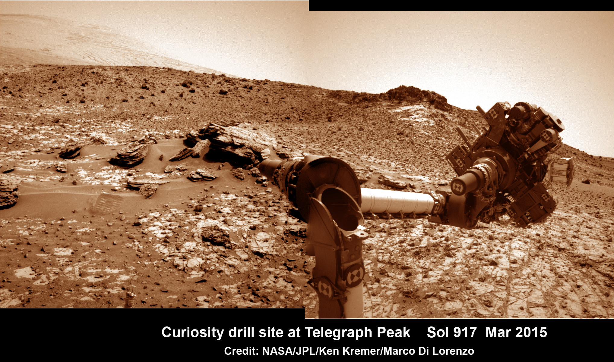
This March 6, 2015 (Sol 917), mosaic of images from the Navcam camera on NASA’s Curiosity Mars rover shows the position in which the rover held its arm for several days after a transient short circuit triggered onboard fault-protection programming to halt arm activities on Feb. 27, 2015, Sol 911. The rover team chose to hold the arm in the same position for several days of tests to diagnose the underlying cause of the Sol 911 event. Navcam camera raw images stitched and colorized. Credit: NASA/JPL-Caltech/Ken Kremer/kenkremer.com/Marco Di Lorenzo
To date, Curiosity’s odometer totals over 5.1 miles (8.4 kilometers) since landing inside Gale Crater on Mars in August 2012.
As of today, Sol 1001, June 1, 2015, she has taken over 246,000 amazing images.
Stay tuned here for Ken’s continuing Earth and planetary science and human spaceflight news.
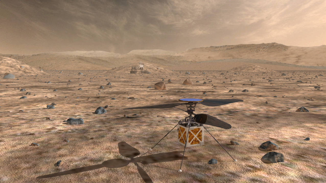
A small drone helicopter currently being developed by engineers at NASA's Jet Propulsion Laboratory could serve as a reconnaissance scout for future Mars rovers, greatly enhancing their effectiveness. Credit NASA JPL
NASA’s Jet Propulsion Laboratory recently announced that it is developing a small drone helicopter to scout the way for future Mars rovers. Why would Mars rovers need such a robotic guide? The answer is that driving on Mars is really hard.
Here on Earth, robots exploring volcanic rims, or assisting rescuers, can be driven by remote control, with a joystick. This is because radio signals reach the robot from its control center almost instantly. Driving on the moon isn’t much harder. Radio signals traveling at the speed of light take about two and half seconds to make the round trip to the moon and back. This delay isn’t long enough to seriously interfere with remote control driving. In the 1970’s Soviet controllers drove the Lunokhod moon rovers this way, successfully exploring more than 40 km of lunar terrain.
Driving on Mars is much harder, because it is so much further away. Depending on its position with respect to Earth, signals can take between 8 and 42 minutes for the round trip. Pre-programmed instructions must be sent to the rover, which it then executes on its own. Each Martian drive takes hours of careful planning. Stereo images taken by the rover’s navigation cameras are carefully scrutinized by engineers. Images from spacecraft orbiting Mars sometimes provide additional information.
A rover can be programmed either to simply execute a list of driving commands sent from Earth, or it can use images taken by its navigation cameras and processed by its on-board computers to measure speed and detect obstacles or hazards by itself. It can even plot its own safe path to a specified goal. Drives based on instructions from the ground are the fastest.
The Mars Exploration Rovers Spirit and Opportunity could drive up to 124 meters in an hour this way. This corresponds to about the length of an American football field. But this mode was also the least safe.
When the rover actively guides itself with its cameras, progress is safer, but much slower because of all the image processing needed. It may progress by as little as 10 meters an hour, which is about the distance from the goal line to the 10 yard line on an American football field. This method must be used whenever the rover doesn’t have a clear view of the route ahead, which is often the case due to rough and hilly terrain.
As of early 2015, the farthest Curiosity has driven in a single day is 144 meters. Opportunity’s longest daily drive was 224 meters, a distance the length of two American football fields.
If ground controllers could get a better view of the path ahead, they could devise instructions allowing a future rover to safely drive much further in a day.
That’s where the idea of a drone helicopter comes in. The helicopter could fly out ahead of the rover every day. Images made from its aerial vantage point would be invaluable to ground controllers for identifying points of scientific interest, and planning driving routes to get there.
Flying a helicopter on Mars poses special challenges. One advantage is that Martian gravity is only 38% as strong as that of Earth, so that the helicopter wouldn’t need to generate as much lift as one of the same mass on Earth. A helicopter’s propeller blades generate lift by pushing air downward. This is harder to do on Mars than on Earth, because the Martian atmosphere is on hundred times thinner. To displace enough air, the propeller blades would need to spin very quickly, or to be very large.
The copter must be capable of flying on its own, using prior instructions, maintaining stable flight along a pre-specified route. It must land and take off repeatedly in rocky Martian terrain. Finally it must be capable of surviving the harsh conditions of Mars, where the temperature plummets to 100 degrees Fahrenheit or lower every night.
The JPL engineers designed a copter with a mass of 1 kilogram; a tiny fraction of the 900 kg mass of the Curiosity rover. Its propeller blades span 1.1 meters from blade tip to blade tip, and are capable of spinning at 3400 rotations per minute. The body is about the size of a tissue box.
The copter is solar powered, with a disk of solar cells gathering enough power every day to power a flight of two to three minutes and to heat the vehicle at night. It can fly about half a kilometer in that time, gathering images for transmission to ground control as it goes. Engineers expect that the reconnaissance that the drone copter gathers will be invaluable in planning a rover’s drives, tripling the distance that can be traveled in a day.
References and further reading:
Thanks to Mark Maimone of NASA Jet Propulsion Laboratory for information about the daily driving distances of Curiosity and Opportunity.
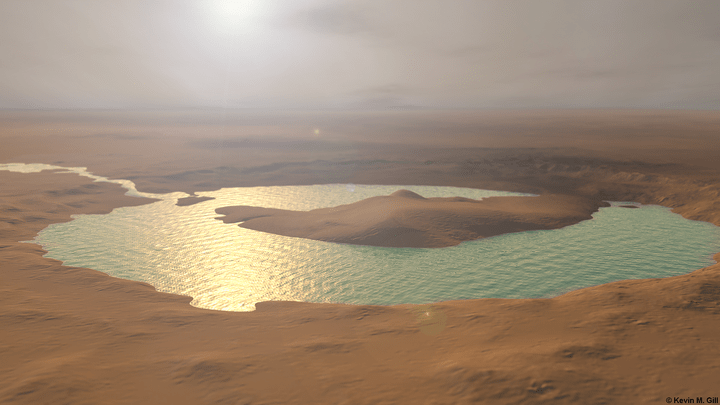
Artist rendition of how the "lake" at Gale Crater on Mars may have looked millions of years ago. Credit and copyright: Kevin Gill.
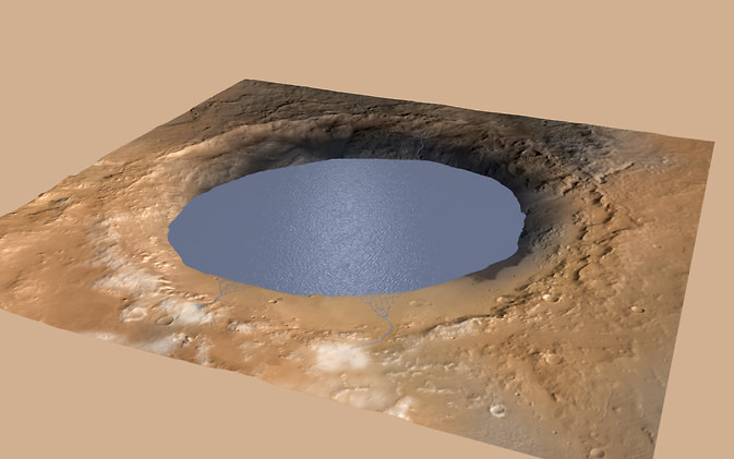
What is now a mountain, was once a lake. That’s the conclusion of the Curiosity Mars rover science team after studying data and imagery from the rover, which indicates that the mountain the rover is now climbing in Gale Crater – Aeolis Mons, or Mount Sharp — was built by sediments deposited in a large lake bed over tens of millions of years.
“Gale Crater had a large lake at the bottom — perhaps even a series of lakes,” said Michael Meyer, lead scientist for NASA’s Mars Exploration Program during a press briefing on Monday, “that may have been big enough to last millions of years.”
This evenly layered rock photographed by the Mast Camera (Mastcam) on NASA’s Curiosity Mars Rover on Aug. 7, 2014, shows a pattern typical of a lake-floor sedimentary deposit not far from where flowing water entered a lake. Credit: NASA/JPL-Caltech/MSSS.
This isn’t the first time that the Mars Science Laboratory team has made the conclusion that a lake once existed in Gale Crater, or even that the water was long-lived. A year ago, the team said that an ancient fresh water lake at the Yellowknife Bay area near Curiosity’s landing site once existed for periods spanning perhaps millions to tens of millions of years in length – before eventually evaporating completely after Mars lost its thicker atmosphere.
But now, the team has garnered a bigger picture of Gale Crater, and they suggest that water could have covered nearly the entirety of the 154-kilometer-wide crater around 3.5 billion years ago, and that the 5-kilometer-high mountain that now towers over the crater could have been formed by repeated cycles of sediment buildup and erosion.
“If our hypothesis for Mount Sharp holds up, it challenges the notion that warm and wet conditions were transient, local, or only underground on Mars,” said Ashwin Vasavada, Curiosity deputy project scientist. “A more radical explanation is that Mars’ ancient, thicker atmosphere raised temperatures above freezing globally, but so far we don’t know how the atmosphere did that.”
By continuing the study of this crater, Vasavada said, the team is “more sure than ever that we’re going to learn about the early history of Mars, it’s changing climate, and the potential for Mars to support life.”
A few months ago, when Curiosity was still a few kilometers away from the base of Aeolis Mons, the science team started noticing distinct patterns on the rocks from images taken by the rover. There were tilted beds of sandstone all facing south in the direction of the mountain. The planetary geologists concluded that these tilted beds of sandstone formed where streams emptied into standing bodies of water, probably lakes.
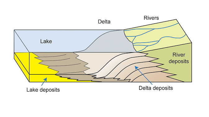
This diagram depicts rivers feeding into a lake. Where the river enters the water body, the water’s flow decelerates, sediments drop out, and a delta forms, depositing a prism of sediment that tapers out toward the lake’s interior. Progressive build-out of the delta through time leads to formation of sediments that are inclined in the direction toward the lake body. Credit: NASA/JPL-Caltech/MSSS/Imperial College.
Sediments carried by flowing water sink when they enter a body of water, forming a sloped wall that slowly advances forward as sediment continues to fall.
In September of this year, when Curiosity arrived at the rocks that form the base of Aeolis Mons at a region the team calls “Kimberley,” they saw a new type of rock, one that forms when tiny particles of sediment slowly settle out within a lake, forming mud at the lake bottom. These ‘mudstones’ are very finely layered, suggesting that the river and lake system was going through cycles of change.
“Layered sandstone or pebble beds at the Kimberley record a build-out or accretion of sediment from north to south,” said Curiosity science team member Sanjeev Gupta, “ and that build-out of inclined beds strongly suggests rivers depositing sediment into a standing body of water.”
This image from Curiosity’s Mastcam shows inclined beds of sandstone interpreted as the deposits of small deltas fed by rivers flowing down from the Gale Crater rim and building out into a lake where Mount Sharp is now. It was taken March 13, 2014, just north of the “Kimberley” waypoint. Credit: NASA/JPL-Caltech/MSSS
Over a span of perhaps millions of years, water flowed from the northern rim of Gale Crater toward the center, bringing sediment that slowly formed the lower layers of Mount Sharp.
After the crater filled to a height of at least a few hundred yards and the sediments hardened into rock, the accumulated layers of sediment were sculpted over time into a mountainous shape by wind erosion that carved away the material between the crater perimeter and what is now the edge of the mountain.
While this is definitely not the first time that evidence of water has been discovered on Mars — evidence from several Mars missions point to wet environments on ancient Mars – scientist have yet to put together a model of Mars’ ancient climate that could have produced long periods warm enough for stable water on the surface.
This illustration depicts a lake of water partially filling Mars’ Gale Crater, receiving runoff from snow melting on the crater’s northern rim. Image Credit: NASA/JPL-Caltech/ESA/DLR/FU Berlin/MSSS
But this latest finding suggests Mars may have maintained a climate that could have produced long-lasting lakes at many locations on the Red Planet, which leads to potentially long-lasting habitable environments.
To learn more about this intriguing region on Mars, over the next few months the Curiosity rover will continue to climb up the lower layers of Aeolis Mons to see if the hypothesis for how it formed holds up. The team will also look at the chemistry of the rocks to see if the water that was once present would’ve been of the kind that could support microbial life.
“With only 30 vertical feet of the mountain behind us, we’re sure there’s a lot more to discover,” said Vasavada.
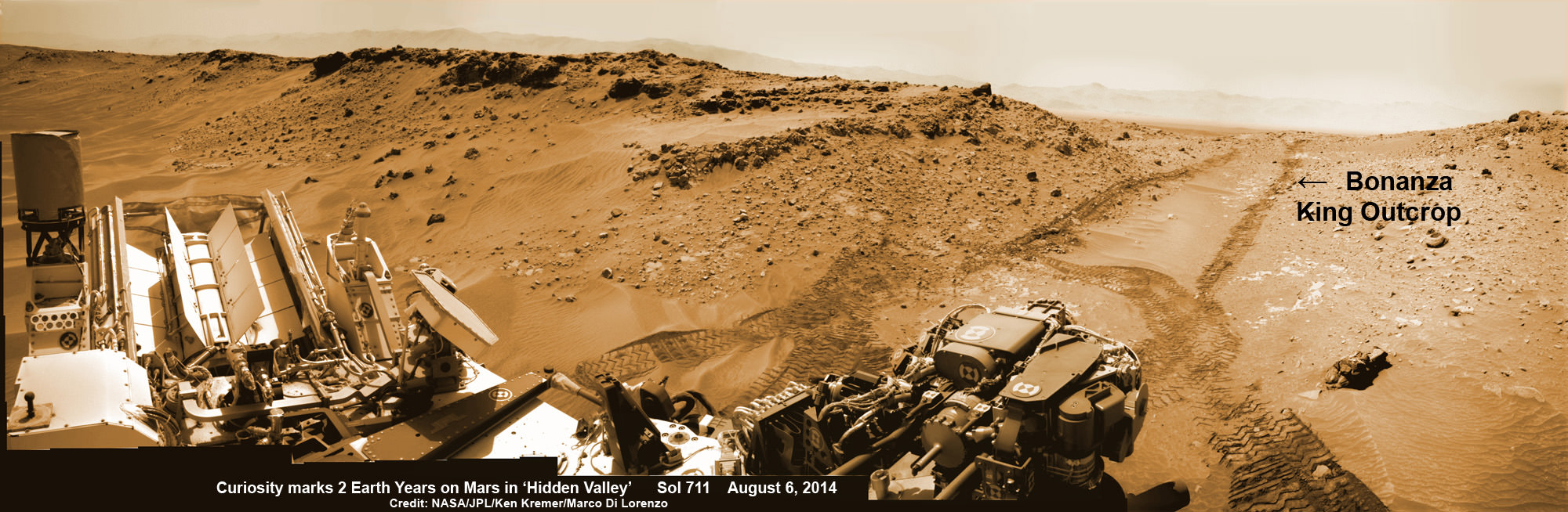
NASA’s Curiosity rover looks back to ramp with potential 4th drill site target at ‘Bonanza King’ rock outcrop in ‘Hidden Valley’ in this photo mosaic view captured on Aug. 6, 2014, Sol 711. Inset shows results of brushing on Aug. 17, Sol 722, that revealed gray patch beneath red dust. Note the rover’s partial selfie, valley walls, deep wheel tracks in the sand dunes and distant rim of Gale crater beyond the ramp. Navcam camera raw images stitched and colorized. Credit: NASA/JPL-Caltech/Ken Kremer-kenkremer.com/Marco Di Lorenzo
Curiosity brushes ‘Bonanza King’ drill target on Mars
NASA’s Curiosity rover looks back to ramp with 4th drill site target at ‘Bonanza King’ rock outcrop in ‘Hidden Valley’ in this photo mosaic view captured on Aug. 6, 2014, Sol 711. Inset shows results of brushing on Aug. 17, Sol 722, that revealed gray patch beneath red dust. Note the rover’s partial selfie, valley walls, deep wheel tracks in the sand dunes and distant rim of Gale crater beyond the ramp. Navcam camera raw images stitched and colorized.
Credit: NASA/JPL-Caltech/Ken Kremer-kenkremer.com/Marco Di Lorenzo[/caption]
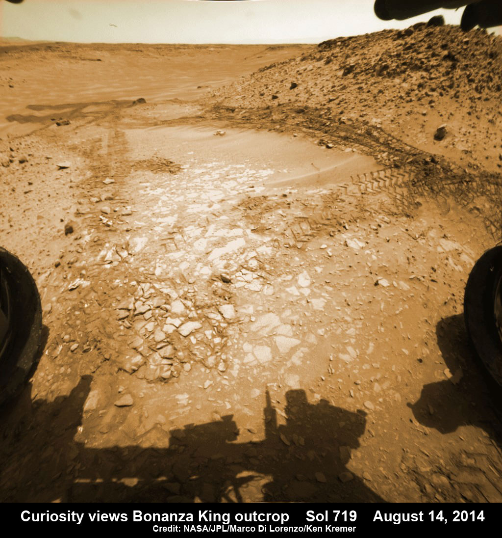
Eagerly eyeing her next drill site on Mars, NASA’s Curiosity rover laid the groundwork by brushing the chosen rock target called ‘Bonanza King’ on Wednesday, Aug. 17, Sol 722, with the Dust Removal Tool (DRT) and collecting high resolution imagery with the Mast Camera (Mastcam) to confirm the success of the operation.
By brushing aside the reddish, more-oxidized dust scientists and engineers leading the mission observed a gray patch of less-oxidized rock material beneath that they anticipated seeing while evaluating the utility of ‘Bonanza King’ as the rover’s fourth candidate for Red Planet rock drilling and sampling.
To date, the 1-ton robot has drilled into three target rocks to collect sample powder for analysis by the rover’s onboard pair of the chemistry labs, SAM and CheMin, to analyze for the chemical ingredients that could support Martian microbes, if they ever existed.
Curiosity rover used the Dust Removal Tool on its robotic arm to brush aside reddish, more-oxidized dust, revealing a gray patch of less-oxidized rock material at a target called “Bonanza King,” visible in this image from the rover’s Mast Camera (Mastcam). Credit: NASA/JPL-Caltech/MSSS
So far everything is proceeding quite well.
The brushing activity also revealed thin, white, cross-cutting veins which is a further indication that liquid water flowed here in the distant past. Water is a prerequisite for life as we know it.
“They might be sulfate salts or another type of mineral that precipitated out of solution and filled fractures in the rock. These thin veins might be related to wider light-toned veins and features in the surrounding rock,” NASA said in a statement.
Based on these results and more from laser zapping with Curiosity’s Chemistry and Camera (ChemCam) instrument on Sol 719 (Aug. 14, 2014) the team decided to proceed ahead.
The imminent next step is to bore a shallow test hole into the brushed area which measures about about 2.5 inches (6 centimeters) across.
If all goes well with the “mini-drill” operation, the team will proceed quickly with full depth drilling to core a sample from the interior of the dinner plate sized rock slab for delivery to Curiosity’s two chemistry labs.
Bonanza King sits in a bright outcrop on the low ramp at the northeastern end of a spot leading in and out of an area called “Hidden Valley” which lies between Curiosity’s August 2012 landing site in Gale Crater and her ultimate destinations on Mount Sharp which dominates the center of the crater.
Just days ago, the rover team commanded a quick exit from “Hidden Valley” to backtrack out of the dune filled valley because of fears the six wheeled robot could get stuck in slippery sands extending the length of a football field.
As Curiosity drills, the rover team is also searching for an alternate safe path forward to the sedimentary layers of Mount Sharp.
To date, Curiosity’s odometer totals over 5.5 miles (9.0 kilometers) since landing inside Gale Crater on Mars in August 2012. She has taken over 178,000 images.
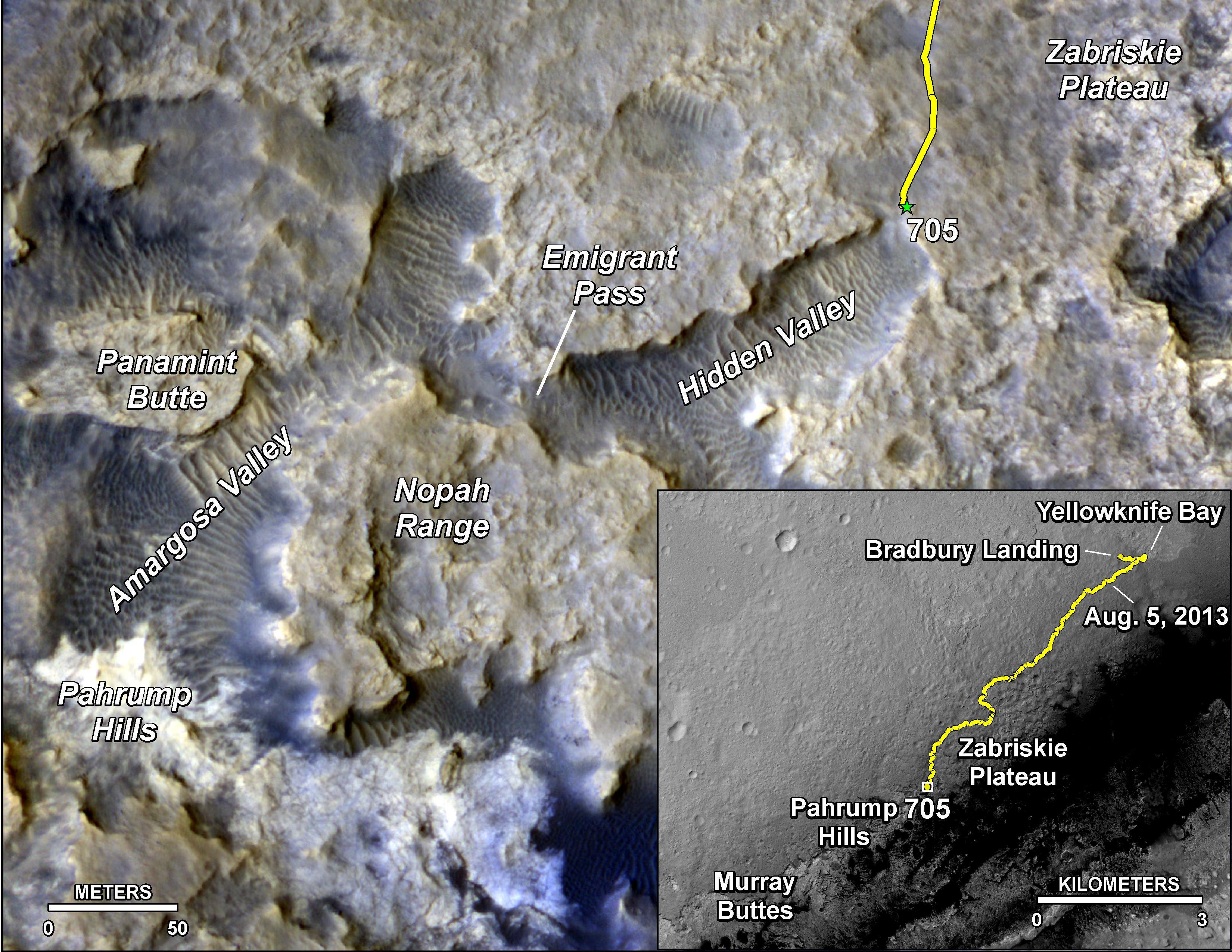
The main map here shows the assortment of landforms near the location of NASA’s Curiosity Mars rover as the rover’s second anniversary of landing on Mars nears. The gold traverse line entering from upper right ends at Curiosity’s position as of Sol 705 on Mars (July 31, 2014). The inset map shows the mission’s entire traverse from the landing on Aug. 5, 2012, PDT (Aug. 6, EDT) to Sol 705, and the remaining distance to long-term science destinations near Murray Buttes, at the base of Mount Sharp. The label “Aug. 5, 2013” indicates where Curiosity was one year after landing. Credit: NASA/JPL-Caltech/Univ. of Arizona
Curiosity still has about another 2 miles (3 kilometers) to go to reach the entry way at a gap in the treacherous sand dunes at the foothills of Mount Sharp sometime later this year.
Mount Sharp is a layered mountain that dominates most of Gale Crater and towers 3.4 miles (5.5 kilometers) into the Martian sky and is taller than Mount Rainier.
“Getting to Mount Sharp is the next big step for Curiosity and we expect that in the Fall of this year,” Dr. Jim Green, NASA’s Director of Planetary Sciences at NASA Headquarters, Washington, DC, told me in an interview making the 2nd anniversary on Aug. 6.
“Drilling on the crater floor will provide needed geologic context before Curiosity climbs the mountain.”
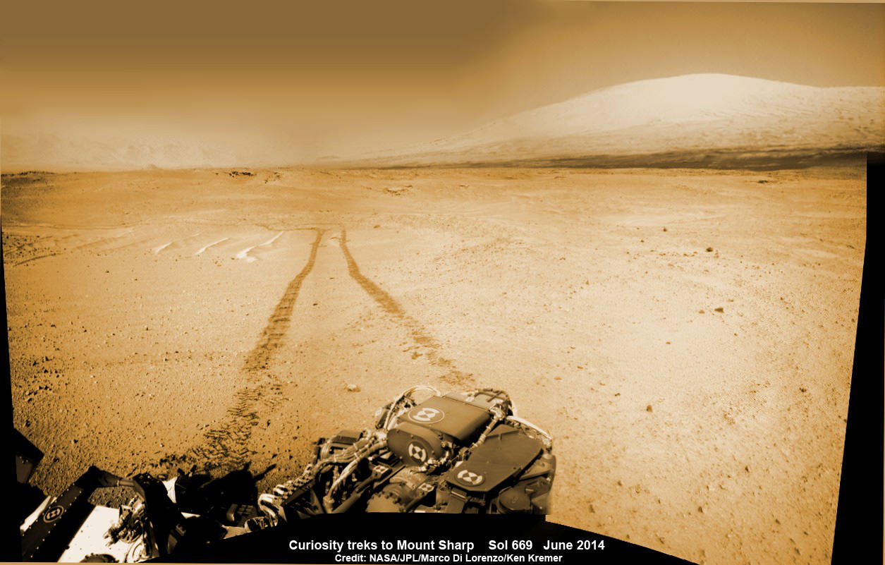
1 Martian Year on Mars! Curiosity treks to Mount Sharp in this photo mosaic view captured on Sol 669, June 24, 2014. Navcam camera raw images stitched and colorized. Credit: NASA/JPL-Caltech/Marco Di Lorenzo/Ken Kremer – kenkremer.com
Read an Italian language version of this story by my imaging partner Marco Di Lorenzo – here
Stay tuned here for Ken’s continuing Rosetta, Curiosity, Opportunity, Orion, SpaceX, Boeing, Orbital Sciences, Dream Chaser, commercial space, MAVEN, MOM, Mars and more planetary and human spaceflight news.
NASA’s Curiosity rover looks back to ramp with 4th drill site target at ‘Bonanza King’ rock outcrop in ‘Hidden Valley’ at site marking her 2nd anniversary on Mars, as shown in this photo mosaic view captured on Aug. 6, 2014, Sol 711. Note the rover’s partial selfie, valley walls, deep wheel tracks in the sand dunes and distant rim of Gale crater beyond the ramp. Navcam camera raw images stitched and colorized. Credit: NASA/JPL-Caltech/Ken Kremer-kenkremer.com/Marco Di Lorenzo
NASA’s Curiosity rover looks back to ramp with 4th drill site target at ‘Bonanza King’ rock outcrop in ‘Hidden Valley’ at site marking her 2nd anniversary on Mars, as shown in this photo mosaic view captured on Aug. 6, 2014, Sol 711. Note the rover’s partial selfie, valley walls, deep wheel tracks in the sand dunes and distant rim of Gale crater beyond the ramp. Navcam camera raw images stitched and colorized.
Credit: NASA/JPL-Caltech/Ken Kremer-kenkremer.com/Marco Di Lorenzo[/caption]
Not wanting to get stuck in a rut, Curiosity’s handlers have commanded NASA’s SUV-sized rover to reverse course and drive out of a potentially hazardous Martian valley of slippery sand with poor wheel traction and instead backtrack towards an enticing nearby spot that the team feels could be the fourth candidate for rock drilling – and thereby widen the scope of the story of habitable environments on the Red Planet.
The new drilling target under up close evaluation right now is named ‘Bonanza King’ – shown in our photo mosaic above.
Bonanza King was chosen after the six wheeled rover unexpectedly experienced significant wheel slippage in the past week while driving over an extended dune field of sandy ripples that basically stopped forward movement inside the Martian valley.
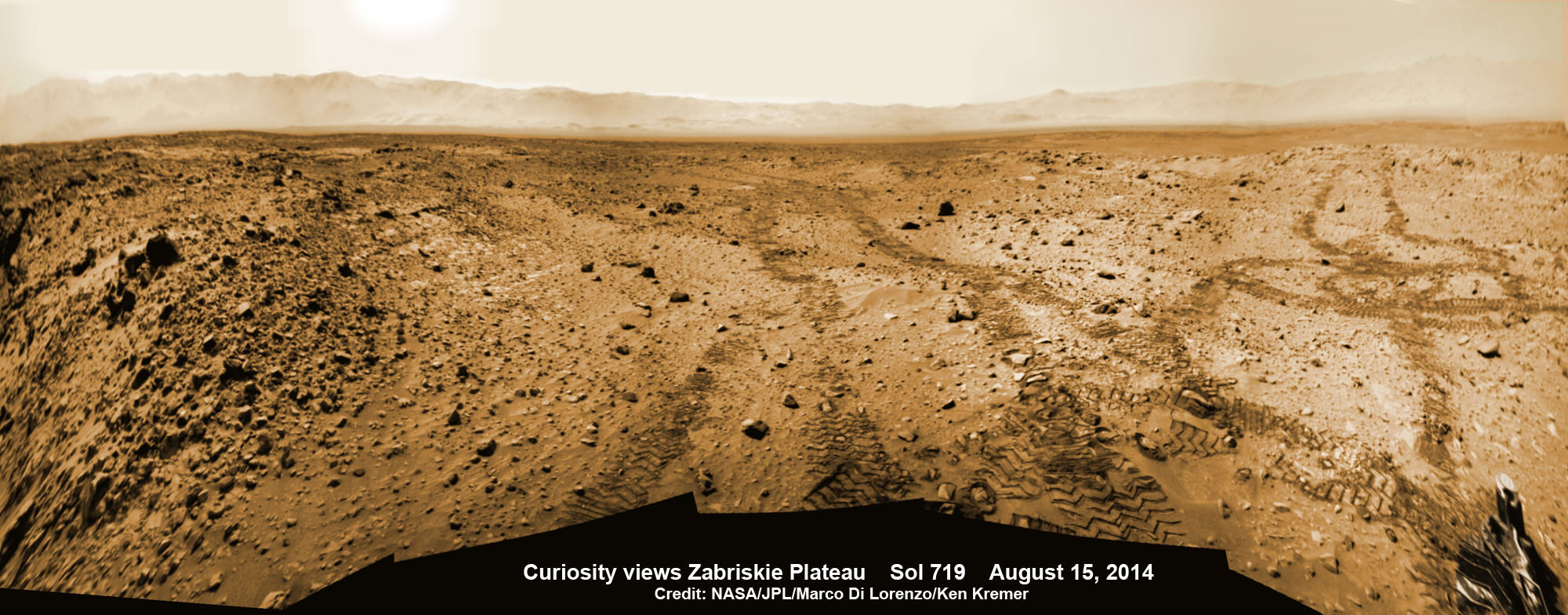
The team was thus in a quandary over whether to push forward on a route through the loose sands of “Hidden Valley” and possibly risk getting mired in a hidden sand trap or drive backwards over a field of sharp rocks on the “Zabriskie plateau” and beyond that are certain to tear further holes in the wheels.
Drilling Candidate Site ‘Bonanza King’ on Mars. This image from the Mast Camera (Mastcam) on NASA’s Curiosity Mars rover shows a portion of the pale rock outcrop that includes the “Bonanza King” target chosen for evaluation as the mission’s fourth rock-drilling site. Raised ridges on the flat rocks — possible mineral veins — are visible at upper and middle right. Tread marks from one of Curiosity’s wheels are visible in the lower half of the image from Sol 707, Aug. 12, 2014. Credit: NASA/JPL-Caltech/MSSS
As reported here last week on the occasion of her 2nd anniversary on Mars since the dramatic touchdown inside Gale Crater on Aug. 6, 2012, Curiosity had been driving merrily through the supposed safe valley of sandy ripples of “Hidden Valley.” She was approaching a bedrock unit named “Pahrump Hills” that for the first time is actually part of the humongous mountain named Mount Sharp she will soon scale and which is the primary science destination of the mission.
But rather soon after driving over a low hump from Zabriskie plateau (see our mosaic below) into Hidden Valley, the robot experienced wheel slippage in the ripples of sand filling the crater floor which was much higher than anticipated. And even worse than comparable test drives in a practice sand lot at JPL.
Curiosity rover looks back to the rocky plains of the Zabriskie plateau from sandy ramp into ‘Hidden Valley’ with 4th drill site target at ‘Bonanza King’ rock outcrop as shown in this photo mosaic view captured on Aug. 14, 2014, Sol 719. Sharp edged rocks at Zabriskie tore new holes into rover wheels. Navcam camera raw images stitched and colorized.
Credit: NASA/JPL-Caltech/Marco Di Lorenzo/Ken Kremer-kenkremer.com
The sandy ripples extend out to the sloping valley walls with no end in sight.
“We need to gain a better understanding of the interaction between the wheels and Martian sand ripples, and Hidden Valley is not a good location for experimenting,” said Curiosity Project Manager Jim Erickson of NASA’s Jet Propulsion Laboratory in Pasadena, California, in a statement.
And since Hidden Valley is as long as a football field and has only two navigable exits at the northeastern and southwestern ends (see map below), the team was forced to drive back to the entrance way at the northern end to consider an alternative route forward to the base of Mount Sharp.
In the meantime while they evaluate the way forward, the team decided that Bonanza King offers similar science to what scientists anticipate at the outcrops at “Pahrump Hills”- a preview of a geological unit that is part of the base of Mount Sharp for the first time since landing rather than still belonging to the floor of Gale Crater.
“Geologically speaking, we can tie the Bonanza King rocks to those at Pahrump Hills. Studying them here will give us a head start in understanding how they fit into the bigger picture of Gale Crater and Mount Sharp,” said Curiosity Deputy Project Scientist Ashwin Vasavada of JPL, in a statement.
Bonanza King sits in an bright outcrop on the low ramp leading in and out of Hidden Valley.
Curiosity rover up close view of ‘Bonanza King’ rock outcrop and 4th drill target looking down from ramp and back into ‘Hidden Valley’ and hazardous dune field of sandy ripples on Aug. 14, 2014, Sol 719. Wheel tracks show where Curiosity drove into the valley, and back out again, earlier in August 2014. The largest of the individual flat rocks in the foreground are a few inches (several centimeters) across. Hazcam camera raw image flattened and colorized. Credit: NASA/JPL-Caltech/Marco Di Lorenzo/Ken Kremer – kenkremer.com
It looks like a pale paving stone. Since its location within the geological layers visible on the ramp is similar to what was expected at the Pahrump Hills outcrop, it’s very appealing to the science team.
Furthermore when one of the rovers wheel’s drove over the outcrop, it cracked open one of the rocks and exposed bright interior material, possibly from mineral veins – which is super exciting from a science perspective as a potential marker for flowing liquid water.
Right now the team is collecting spectral data with the science instruments to assess its science utility and is planning a super fast drilling campaign, far shorter than the prior three.
The plan would be to core a sample from the interior of the dinner plate sized rock slab for delivery to Curiosity’s pair of the onboard chemistry labs, SAM and CheMin to analyze for the chemical ingredients to support miartin microbes, if they ever existed.
“This outcrop on the ramp is too appealing to pass up,” Vasavada said.
The main map here shows the assortment of landforms near the location of NASA’s Curiosity Mars rover as the rover’s second anniversary of landing on Mars nears. The gold traverse line entering from upper right ends at Curiosity’s position as of Sol 705 on Mars (July 31, 2014). The inset map shows the mission’s entire traverse from the landing on Aug. 5, 2012, PDT (Aug. 6, EDT) to Sol 705, and the remaining distance to long-term science destinations near Murray Buttes, at the base of Mount Sharp. The label “Aug. 5, 2013” indicates where Curiosity was one year after landing. Credit: NASA/JPL-Caltech/Univ. of Arizona
To date, Curiosity’s odometer totals over 5.5 miles (9.0 kilometers) since landing inside Gale Crater on Mars in August 2012. She has taken over 178,000 images.
Curiosity still has about another 2 miles (3 kilometers) to go to reach the entry way at a gap in the treacherous sand dunes at the foothills of Mount Sharp sometime later this year.
Mount Sharp is a layered mountain that dominates most of Gale Crater and towers 3.4 miles (5.5 kilometers) into the Martian sky and is taller than Mount Rainier.
“Getting to Mount Sharp is the next big step for Curiosity and we expect that in the Fall of this year,” Dr. Jim Green, NASA’s Director of Planetary Sciences at NASA Headquarters, Washington, DC, told me in an interview making the 2nd anniversary on Aug. 6.
Up close view of hole in one of rover Curiosity’s six wheels caused by driving over rough Martian rocks. Mosaic assembled from Mastcam raw images taken on Dec. 22, 2013 (Sol 490). Credit: NASA/JPL/MSSS/Ken Kremer – kenkremer.com/Marco Di Lorenzo
Stay tuned here for Ken’s continuing Rosetta, Curiosity, Opportunity, Orion, SpaceX, Boeing, Orbital Sciences, Dream Chaser, commercial space, MAVEN, MOM, Mars and more planetary and human spaceflight news.
1 Martian Year on Mars!
Curiosity treks to Mount Sharp in this photo mosaic view captured on Sol 669, June 24, 2014. Navcam camera raw images stitched and colorized. Credit: NASA/JPL-Caltech/Marco Di Lorenzo/Ken Kremer – kenkremer.com2 Earth Years on Mars! NASA’s Curiosity rover celebrated the 2nd anniversary on Mars at ‘Hidden Valley’ as shown in this photo mosaic view captured on Aug. 6, 2014, Sol 711. Note the valley walls, rover tracks and distant crater rim. Navcam camera raw images stitched and colorized. Credit: NASA/JPL-Caltech/Ken Kremer-kenkremer.com/Marco Di Lorenzo