Vast Areas of Low Latitude Subsurface Ice Found on Mars

Color image of a region in Holden Crater. Credit: NASA/JPL/University of Arizona

[/caption]

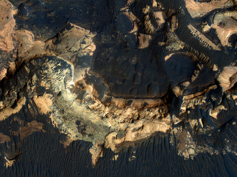
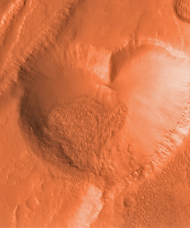
There could be more subsurface ice on Mars than previously thought, and vast stretches of it may lie just south of the equator. Indeed, one of the proposed landing sites for the Mars Science Laboratory could hold the mother lode of enticing scientific prospects. Observations from two spacecraft, the Mars Reconnaissance Orbiter and Mars Express, have revealed potential subsurface ice deposits in areas just south of the equator, including one near Holden Crater, with an estimated reservoir of perennial subsurface water ice of about 50 – 500 kg m -2 just two or three meters beneath the surface. This is the first evidence of ice at “tropical” latitudes on Mars as low as 25 degrees.


In 2009, MRO observations revealed water ice as low as 45 degrees North in a recent small impact crater, and permanent water ice at Mars’ poles is known to exist. But most robotic missions – and hopefully one day human missions – need to land closer to the equator to meet safety criteria and engineering constraints. As evidence, the four proposed landing sites for the MSL hover within 25 degrees of the equator.*

Of course, subsurface ice can’t be seen directly on Mars, but certain surface characteristics and thermal properties belie potential underground ice. The OMEGA (Observatoire pour la Minéralogie, l’Eau, les Glaces et l’Activité ) onboard Mars Express and CRISM (Compact Reconnaissance Imaging Spectrometer for Mars) onboard the Mars Reconnaissance Orbiter use near-infrared imaging spectrometers to measure solar radiation scattered by the surface, providing spectral images that have been used to assess the composition of both minerals and condensates on the surface of Mars.

What drew scientists to this region, were observed surface distributions of seasonal CO2 frost on pole facing slopes. Carbon dioxide ice usually only forms on the surface if there is a cold layer beneath, which can come from water ice or bedrock.

But in this case, Mathieu Vincendon and his team at Brown University concluded that bedrock couldn’t be responsible for creating the observed thermal properties that stores and releases heat two or three meters beneath the surface. Evidence of a uniform layer of bedrock stretching across the equatorial region has never been seen in orbital images, which would have been revealed by erosion or impact processes.

“Using different modeling hypotheses within the range of uncertainties leads to the result that water ice is present within one meter of the surface on all 20-30° pole facing slopes down to about 25°S,” the team writes in their paper. “ The relevant thermal depths probed are 2 or 3 meters. Hence, an ice rich layer that thick is implied, which leads to an estimated reservoir of perennial subsurface water ice of about 50 – 500 kg m -2 on steep slopes.”

The team believes that the subsurface ice could be possible remnants of the last ice age on Mars, and could provide water that will be needed for the future exploration of Mars. More thermal measurements of seasonal temperature variations could help to derive more precise permafrost depths.

Holden crater is located at the edge of the subsurface water ice area at 26°S.

*Eberswalde Crater is -23.90 degrees S, Mawrth Vallis is 23.99 degrees N, Gale crater is -4.49 degrees S, and Holden is -26.4 degrees S.

Sources: arxiv, Technology Review Blog

From Mars with Love on Valentines Day

A heart-shaped feature in the Arabia Terra region of Mars is show on the left, with additional context on the right, in excerpts of an image taken by the Context Camera on NASA's Mars Reconnaissance Orbiter. Image Credit: NASA/JPL-Caltech/MSSS

[/caption]

Happy Valentine’s Day from Mars to all the readers of Universe Today !

Well it’s truly a solar system wide Valentines celebration. From the Moon, Mars and even Comet Temple 1 with some pixie Stardust for the romantic rendezvous upcoming in a few short hours [Stardust-NExT Flyby at 11:37 p.m. EST Feb 14].

The Martian camera team from Malin Space Systems, San Diego, wishes to share a special heart-shaped feature from Arabia Terra – images above and below – with all Mars fans on this St. Valentine’s Day, Feb. 14, 2011. And certainly, I love Mars ! Especially those gorgeous and brainy twin gals Spirit & Opportunity.

Heart-shaped feature in Arabia Terra on Mars at 21.9 degrees north latitude, 12.7 degrees west longitude. Credit: NASA/JPL-Caltech/MSSS.
The image was taken on May 23, 2010 – at the start of northern summer on Mars – by the Malin-built and operated Context Camera on NASA’s Mars Reconnaissance Orbiter.

The bright heart shaped feature is about 1 kilometer (0.6 mile) long. Arabia Terra lies in the northern hemisphere of Mars

The tip of the heart lies above a small impact crater centered at 21.9 degrees north latitude, 12.7 degrees west longitude.

According to a JPL press release, “The crater is responsible for the formation of the bright, heart-shaped feature. When the impact occurred, darker material on the surface was blown away, and brighter material beneath it was revealed.

PIA13799: Heart-Shaped Feature in Arabia Terra (Wide View). Credit: NASA/JPL-Caltech/MSSS.
Some of this brighter material appears to have flowed further downslope to form the heart shape, as the small impact occurred on the blanket of material ejected from a much larger impact crater.

The Jet Propulsion Laboratory, Pasadena, Calif manages MRO for NASA.

More Martian hearts images below from another Malin built camera aboard NASA’s Mars Global Surveyor orbiter

Happy Valentines Day from Mars Global Surveyor (MGS)
This heart shaped pit on Mars is located on the east flank of the Alba Patera volcano in northern Tharsis. The pit was formed by collapse within a straight-walled trough known in geological terms as a graben. Graben are formed along fault lines by expansion of the bedrock terrain. Credit: NASA/JPL-Caltech/MSSS.
10 Martian Hearts for Valentine’s Day.
Mesas and depressions from all across Mars. Images taken by Mars Global Surveyor from 2001 to 2004. Credit: NASA/JPL-Caltech/MSSS.
Heart shaped landforms on Mars – or perhaps a box of chocolates !
Image taken by Mars Global Surveyor. Credit: NASA/JPL-Caltech/MSSS

Active Changes Occuring in Mars’ Northern Hemisphere

A time-series of black and white and false-color sub-images, from left to right at three sites in a field of transverse dunes at 84.7°N, 0.7°E shows that extensive erosion has taken place in one Mars year. Image courtesy of Science/AAAS.

[/caption]

Mars, it is a-changin’, and more than scientists expected. Several series of before-and-after images taken by the HiRISE camera on the Mars Reconnaissance Orbiter the past two years show sand dunes in Mars northern hemisphere changing – both gradually and suddenly. A team of researchers analyzing the images say that the changes have been caused mostly by sand and ice cascading down the slipfaces of the dunes. But, also, there could be “alien” processes that we don’t see occurring on Earth.

“The numbers and magnitude of the changes have been really surprising,” said HiRISE Deputy Principal Investigator Candice Hansen.

The white arrows point to a location on the brink of this dune at 84°N, 233°E that had no alcove in the first year of HiRISE operation (MY29) 
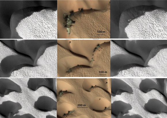
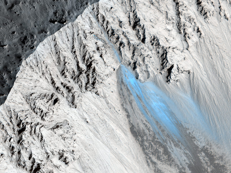
and experienced sublimation activity (middle), which resulted in the new alcove and fan (with total length of 120 m) in MY30. The layer of new material forming the apron is very thin; the original ripples have not been completely buried. Image courtesy Science/AAAS.

In the past, Mars was thought to be a dead world, frozen in time with not many changes taking place on its surface. But since the arrival of high-resolution cameras orbiting the Red Planet – first on the Mars Global Surveyor, and now on MRO and ESA’s Mars Express – that notion has fallen by the wayside. Avalanches, new gullies and now shifting sand dunes are appearing regularly on images from Mars.

Even with the known winds on Mars, scientists had considered the dunes to be fairly static, shaped long ago when winds on the planet’s surface were thought to be much stronger than they are today.

Hansen and her colleagues’ new paper that is published in this week’s edition of the journal Science identifies the seasonal changes from a layer of frozen carbon dioxide – a.k.a or dry ice – which covers the region in winter and sublimates away in the spring, along with stronger-than-expected gusts of wind as initiating sand transport on the northern dunes of Mars.

Three images of the same location taken at different times show seasonal activity causing sand avalanches and ripple changes on a Martian dune. Credit: NASA/JPL/The University of Arizona.

“This gas flow destabilizes the sand on Mars’ sand dunes, causing sand avalanches and creating new alcoves, gullies and sand aprons on Martian dunes,” Hansen said. “The level of erosion in just one Mars year was really astonishing. In some places hundreds of cubic yards of sand have avalanched down the face of the dunes.”

Recently, scientists have seen how the scars of past sand avalanches could be partially erased in just one Mars year. Models of Mars’ atmosphere do not predict wind speeds adequate to lift sand grains, and data from Mars landers such as Phoenix show high winds are a rare occurrence.

“Perhaps polar weather is more conducive to high wind speeds,” Hansen said.

The dune margin in MY29 image PSP_008968_2650 at 84.7°N, 0.7°E is compared with MY30 ESP_017895_2650. Image courtesy of Science/AAAS

The researchers say changes were seen in about 40 percent of far-northern monitoring locations over the two-Mars-year period of the study.

Related research with HiRISE previously identified gully-cutting activity in smaller fields of sand dunes covered by seasonal carbon-dioxide ice in Mars’ southern hemisphere. A report four months ago showed that those changes coincided with the time of year when ice builds up.

A false-color image of dark sand dunes at high northern latitudes on Mars that are covered seasonally by a layer of condensed carbon dioxide (dry ice)
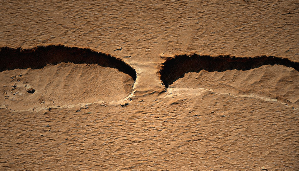
, shown in this image. When the sun rises in the spring the ice begins to sublimate. Gas flow from the bottom of the ice layer propels sand from the dunes out through cracks to the top of the ice and down the dune slipface. Image courtesy of NASA/JPL/University of Arizona

“The role of the carbon-dioxide ice is getting clearer,” said Serina Diniega of NASA’s Jet Propulsion Laboratory, Pasadena, Calif., lead author of the earlier report and a co-author of the new report. “In the south, we saw before-and-after changes and connected the timing with the carbon-dioxide ice. In the north, we’re seeing more of the process of the seasonal changes and adding more evidence linking gully activity with the carbon dioxide.”

“Understanding how Mars is changing today is a key first step to understanding basic planetary processes and how Mars changes over time,” said HiRISE Principal Investigator Alfred McEwen, a co-author of both reports. “There’s lots of current activity in areas covered by seasonal carbon-dioxide frost, a process we don’t see on Earth. It’s important to understand the current effects of this unfamiliar process so we don’t falsely associate them with different conditions in the past.”

Source: Science

Spots Among Spots on Mars

A spotted landscape on Mars. Credit: NASA/JPL/U of AZ

[/caption]

This unusual landscape on Mars can be found within a crater on the southern hemisphere of the Red Planet. But if you look on the actual location of this HiRISE image on the Google Map of Mars, below, you’ll see these spots are just spots among spots.

An area of heavy cratering on Mars. Credit: Google Maps (Mars)

Seasonal spots appear on dunes found on the floors of craters on Mars; most likely it is from carbon dioxide frost that is “defrosting” and later may sublimate away. At one time, these spots that seemingly come and go with the seasons were thought to be signs of life on Mars. The jury is still out on that line of thinking.

See the original picture on the HiRISE website and zoom around the Google Mars (below the image on the HiRISE site) to see the entire area, or go to Google Mars.

Groovin’ to the Latest Images from Mars

The folks from the HiRISE Camera on the Mars Reconnaissance Orbiter have put together a video with some groovin’ music of the latest images from the Red Planet, courtesy of HiRISE, the bestest camera in all of Marsdom. There’s an elliptical impact crater, giant gullies, sinuous ridges and a Swiss Cheese smiley face. No foolin’!

Latest From Mars: Frosty Landscapes, Ancient Lakebed, Potential Landing Site

Richardson Crater Dunes, Partially Defrosted. Credit: NASA/JPL/University of Arizona

A new batch of images has been released by the HiRISE camera on the Mars Reconnaissaince Orbiter and –as usual — they are stunning. In the image above, there is a lot going on! Numerous dust devil tracks have left their criss-crossing marks on the dune field found in Richardson Crater. The dunes are covered by seasonal carbon dioxide frost, which has only partially defrosted, although the image was acquired late in Mars’ southern spring. There are channels carved into the ground and HiRISE scientists says the could have been created by blocks of carbon dioxide ice (dry ice) slide down the slope and sublimate (evaporate directly from solid to gas). Wouldn’t that be fun to be there and watch happen!

See more of the “coolest” and latest Mars images from HiRISE below:

Continue reading “Latest From Mars: Frosty Landscapes, Ancient Lakebed, Potential Landing Site”

Rock Bridge on Mars

A landform on Mars that looks like a naturally occuring bridge across a chasm. Credit: NASA/JPL/U of Arizona/ colorization by Stu Atkinson.

[/caption]

The HiRISE camera on the Mars Reconnaissance Orbiter took an image of a thin channel, and a portion of it contains a naturally occurring bridge over the chasm. Kelly Kolb from the HiRISE team says it is probably a remnant of the original surface, the rest of which has collapsed downward. It isn’t likely there’s a opening underneath the formation, but if there were, it would look very similar to a rock bridge formation found in Jordan in the Wadi Rum, the Valley of the Moon. See an image below.

Kolb also said this is unlikely to be a channel formed by a running water, as there are no obvious source or deposit regions. The channel is probably a just a collapse feature.

And see the full HiRISE image of the thin channel, found in Mars northern hemisphere between some “knobs” called Tartarus Colles, below.

Any chance the Mars rockbridge could look like this one in Wadi Rum, Jordan -- also known as the Valley of the Moon?
Small Winding Channel in Tartarus Colles. Credit: NASA/JPL/University of Arizona

For more information about this image on Mars, see the HiRISE website.

More Recent Landslides Spotted on Mars

Recent Landslide in Zunil Crater on Mars. Credit: NASA/JPL/University of Arizona

[/caption]

Thanks to the Mars Reconnaisance Orbiter and the on-board HiRISE camera, scientists are able to monitor Mars for changes taking place on the landscape. They do this by comparing older images with newer ones, and also by seeing “fresh” features — like this recent landslide in Zunil Crater. “The color and albedo patterns indicate that a landslide occurred here very recently–too recently to have been re-covered by dust,” writes Alfred McEwen, principal investigator of HiRISE, writing on the camera’s website. “Looking for changes such as this will help us to better understand active processes.” McEwen said the landslide could have been triggered by a Marsquake or a small impact event.”

See more recent landslides below:

This landslide was spotted by Stu Atkinson; boulders and debris are below a steep north polar boundary scarp. Credit: NASA/JPL/University of Arizona

Our ‘eagle-eyed’ pal Stuart Atkinson found this landslide on a steep scarp in the north polar region. It looks as though a lot of rock has fallen from the cliff, and discussion among other image artists on UnmannedSpaceflight.com indicated that the blue areas could easily be patches of ice deposited from the cliff face. You can see the original image at the HiRISE website.

Frosted Gullies in the Northern Summer. Credit: NASA/JPL/University of Arizona

This image is so amazing, in that from orbit, we are looking down the side of a crater wall, where gullies have formed. There are two schools of thought on these types of gullies: one, many scientists believe that these gullies have been carved by liquid water, and were carved recently, so this recent, present-day activity is of immense interest.

A second opinion is that accumulations of frost in the gully alcoves starts an avalanche of loose material that does not involve liquid water. The MRO scientists will continue to analyze many images like this in order to try and answer the broader question of whether liquid water is responsible for the the gullies, landslides and avalanches or not.

andslides along the Walls of Bahram Vallis. Credit: NASA/JPL/University of Arizona

This image of Bahram Vallis has large mounds of material at the base of the valley floor. These deposits of material have the characteristic shape of rotational landslides or slumps on Earth where material along the entire wall slumps down and piles debris at the base of the slope, “much like a person who slumps down the back of a chair,” writes Frank Chuang from the HiRISE team. “Right at the cliff edge at the top of the slope, the shape of the area where the valley wall gave way to a landslide is not straight, but rather curved or semi-circular. This is typical of large landslides where the failure area has an arcuate “crown” shape. The fact that landslides have occurred here indicates that the valley walls are not stable and the materials respond to Martian gravity with mass movements.”

See more images at the HiRISE website.

Best Class Project Ever: 7th Graders Find a Cave on Mars

Sixteen seventh-graders at Evergreen Middle School in Cottonwood, Calif., found the Martian pit feature at the center of the superimposed red square in this image. Image Credit: NASA/JPL-Caltech/ASU

[/caption]

Tip number one on “How to impress your classmates:” Find a mysterious cave on Mars. A group of 16 seventh-graders at Evergreen Middle School in Cottonwood, California, USA found a dark pit that appears to be an opening to a cave on Mars. Dennis Mitchell’s science class were examining Martian lava tubes as their project in the Mars Student Imaging Program offered by NASA and Arizona State University, which takes advantage of the huge database of images taken by the Mars Odyssey spacecraft. The students found the skylight pit on the slope of an equatorial volcano named Pavonis Mons, and it appears to be an entrance to an underground lava tube. Similar ‘cave skylight’ features have been found elsewhere on Mars, but this is the first seen on this volcano.

“The students developed a research project focused on finding the most common locations of lava tubes on Mars,” Mitchell said. “Do they occur most often near the summit of a volcano, on its flanks or the plains surrounding it?”

Mitchell said he and his students have been surprised how much interest there has been nation-wide in their discovery. “They were kind of shocked about the interest, and I think that they are just now starting to realize that they made a pretty neat discovery.”

The imaging program allows students in upper elementary grades through to college to participate in Mars research by having them develop a geological question to answer, and then directing the teams for the Mars-orbiting camera to take an image to answer their question. Since MSIP began in 2004, more than 50,000 students have participated.

Now, because of this find, the HiRISE high resolution camera on the Mars Reconnaissance Orbiter will take follow-up images of the pit to provide a better look at the object. HiRISE can image the surface at about 30 centimeters (12 inches) per pixel, which may allow a look inside the hole in the ground. This is part of the HiWISH program, where the public can submit suggestions to the science team for locations on Mars to the camera to image.

“It gives the students a good understanding of the way research is conducted and how that research can be important for the scientific community. This has been a wonderful experience,” Mitchell said.”

“Yeah it was a lot of fun because it wasn’t like any other science that we did, because we actually got to interact with real scientists instead of just people out of the book and stuff,” said 13-year-old Kody Rulofson, one of the students in Mitchell’s class.

Kody’s mother, Doni Rulofson said Kody and his twin brother Chase, also in the class, are inspired by the experience they had finding the cave. “They’re excited. They’re just beyond belief, they’re like, ‘we knew it was something really cool but we had no idea it was this much of an interest to NASA.'”

Odyssey has been orbiting the Red Planet since 2001, returning data and images of the Martian surface and providing relay communications service for Mars Rovers Spirit and Opportunity. Find out more about Odyssey here.

MRO has been in orbit since 2006, and has also amassed a huge database of images, which can be seen here.

Source: NASA

New Images Suggest More Recent Lakes on Mars

Image of a channel between putative lakes from the Context Camera (CTX) onboard NASA’s Mars Reconnaissance Orbiter (MRO).

Modern Mars is frigid and dry, but new evidence suggests that in some locations on the equator there may have been lakes as recently as 3 billion years ago.

Researchers from Imperial College London and University College London studied images from the context camera (CTX) on NASA’s Mars Reconnaissance Orbiter (MRO) of several flat-floored depressions in Ares Vallis, near the martian equator.

Previously these depressions were thought to be due to the collapse of the surface as ground ice sublimated directly to gas, but CTX images reveal small channels connecting the depressions, suggesting that water flowed between them. Similar features can be found in “thermokarst” landscapes in Alaska and elsewhere, where permafrost is melting to create lakes and streams.

To determine the age of the features, the scientists counted more than 35,000 craters in the area. Assuming that the current surface was continuously exposed to impacts from space since it was emplaced, the density of craters points to an age of roughly three billion years.

Previously, it was thought that Mars dried up between 4 and 3.8 billion years ago, but if the cratering age from this study is correct, these new results suggest at least brief periods later in martian history when lakes could exist.

The lead author, Dr Nicholas Warner, from the Department of Earth Science and Engineering at Imperial College London, said: “Most of the research on Mars has focused on its early history and the recent past. Scientists had largely overlooked the Hesperian Epoch as it was thought that Mars was then a frozen wasteland. Excitingly, our study now shows that this middle period in Mars’ history was much more dynamic than we previously thought.”

It is not clear how long-lived the lakes were, but Warner and colleagues suggest that they may have served as oases for life in an otherwise inhospitable world. They also suggest that these lakes would be an interesting landing site for future robotic missions.

What’s the next step? The researchers plan to study other equatorial areas, including the mouth of Ares Vallis and Chryse Planitia to see how widespread the putative lakes were.