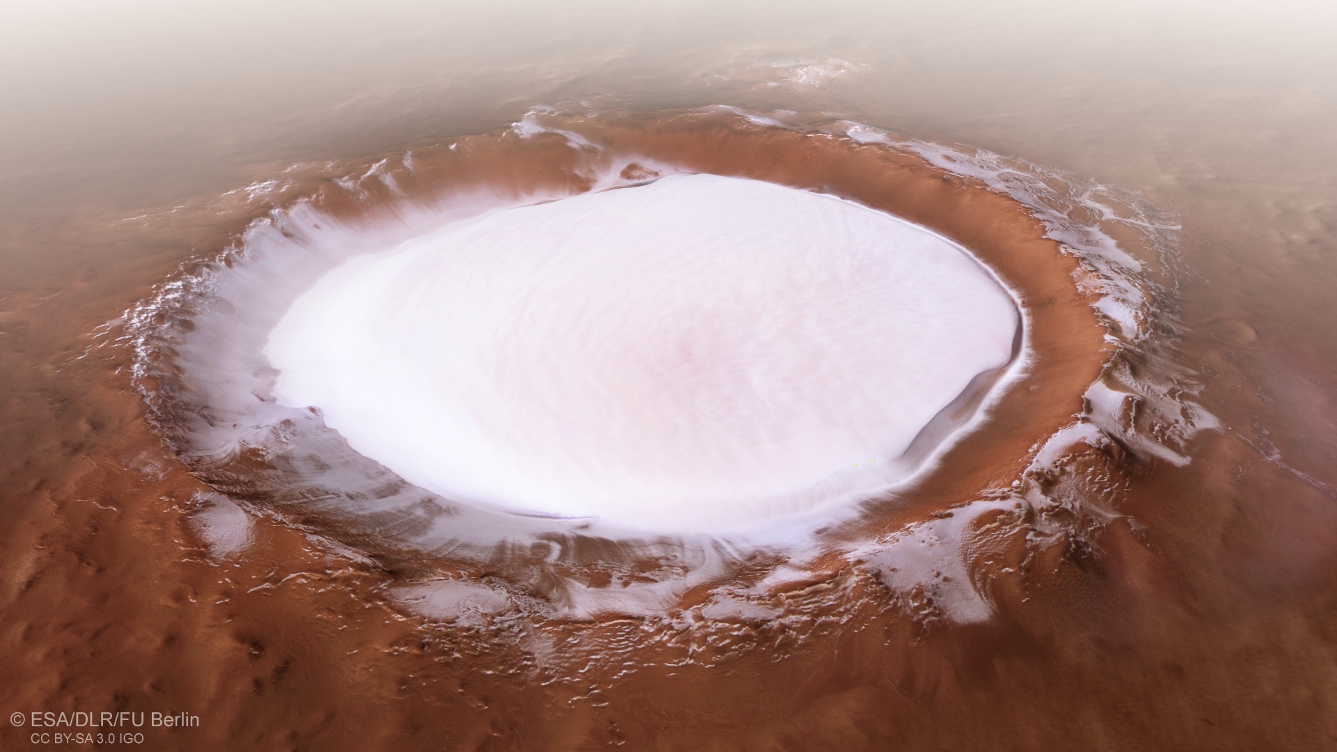
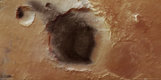
This image from ESA’s Mars Express shows Korolev crater, an 82-kilometre-across feature found in the northern lowlands of Mars. Credit: ESA/DLR/FU Berlin
On June 2nd, 2003, the European Space Agency’s Mars Express mission left Earth to begin its journey to Mars. Six months later (on December 25th) the spacecraft fired its main engine and entered orbit around Mars. This Christmas will therefore mark the fifteenth anniversary of the orbiter’s arrival and all the observations it has made of the Red Planet since then.
Appropriately, the Mars Express mission was able to commemorate this occasion by capturing some beautiful photos of a Martian crater that remains filled with ice all year round. This feature is known as the Korolev crater, which measures 82 km (51 mi) in diameter and is located in the northern lowlands, just south of the northern polar ice cap.
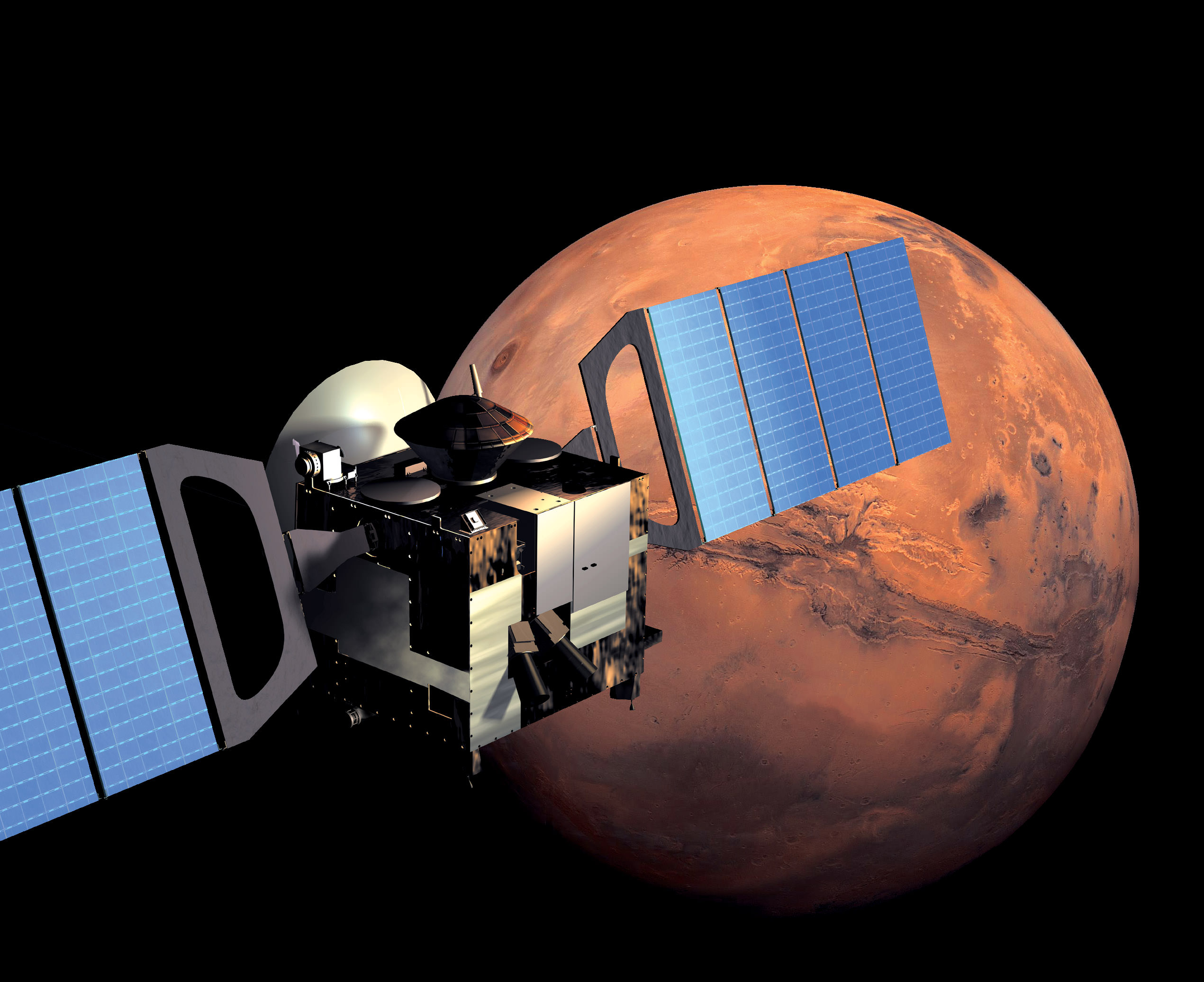
The Trace Gas Orbiter arrived at Mars in 2016. Credit: ESA
In 2003, scientists from NASA’s Goddard Space Center made the first-ever detection of trace amounts of methane in Mars’ atmosphere, a find which was confirmed a year later by the ESA’s Mars Express orbiter. In December of 2014, the Curiosity rover detected a tenfold spike of methane at the base of Mount Sharp, and later uncovered evidence that Mars has a seasonal methane cycle, where levels peak in the late northern summer.
Since it’s discovery, the existence of methane on Mars has been considered one of the strongest lines of evidence for the existence of past or present life. So it was quite the downer last week (on Dec. 12th) when the science team behind one of the ESA’s ExoMars Trace Gas Orbiter (TGO) spectrometers announced that they had found no traces of methane in Mars’ atmosphere.
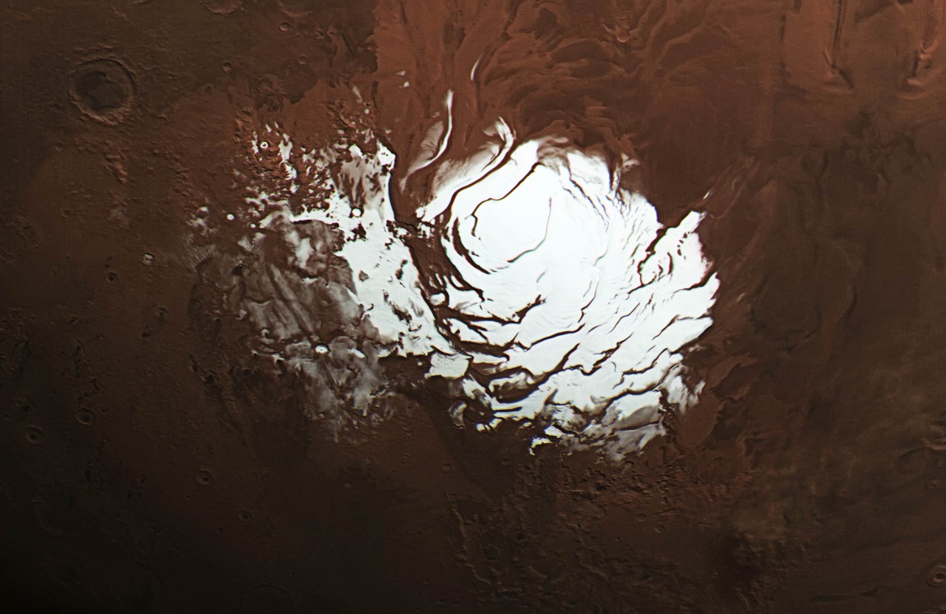
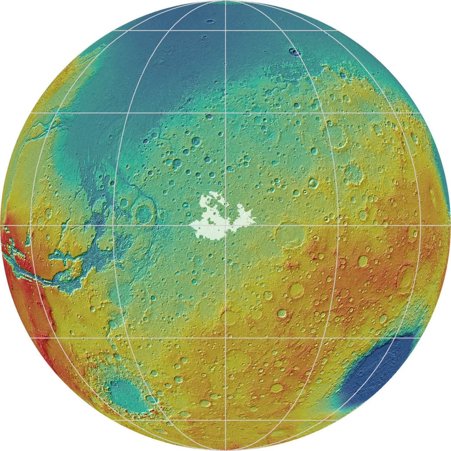
Mars’ south polar ice cap. Credit: ESA / DLR / FU Berlin /
According to evidence gathered by multiple robotic orbiters, rovers, and landers over the course of several decades, scientists understand that Mars was once a warmer, watery place. But between 4.2 and 3.7 billion years ago, this began to change. As Mars magnetic field disappeared, the atmosphere slowly began to be stripped away by solar wind, leaving the surface the cold and dry and making it impossible for water to exist in liquid form.
While much of the planet’s water is now concentrated in the polar ice caps, scientists have speculated some of Mars’ past water could still be located underground. Thanks to a new study by a team of Italian scientists, it has now been confirmed that liquid water still exists beneath Mars’ southern polar region. This discovery has put an end to a fifteen-year mystery and bolstered the potential for future missions to Mars.
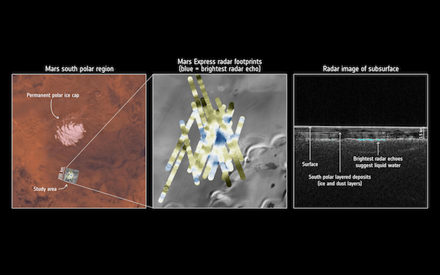
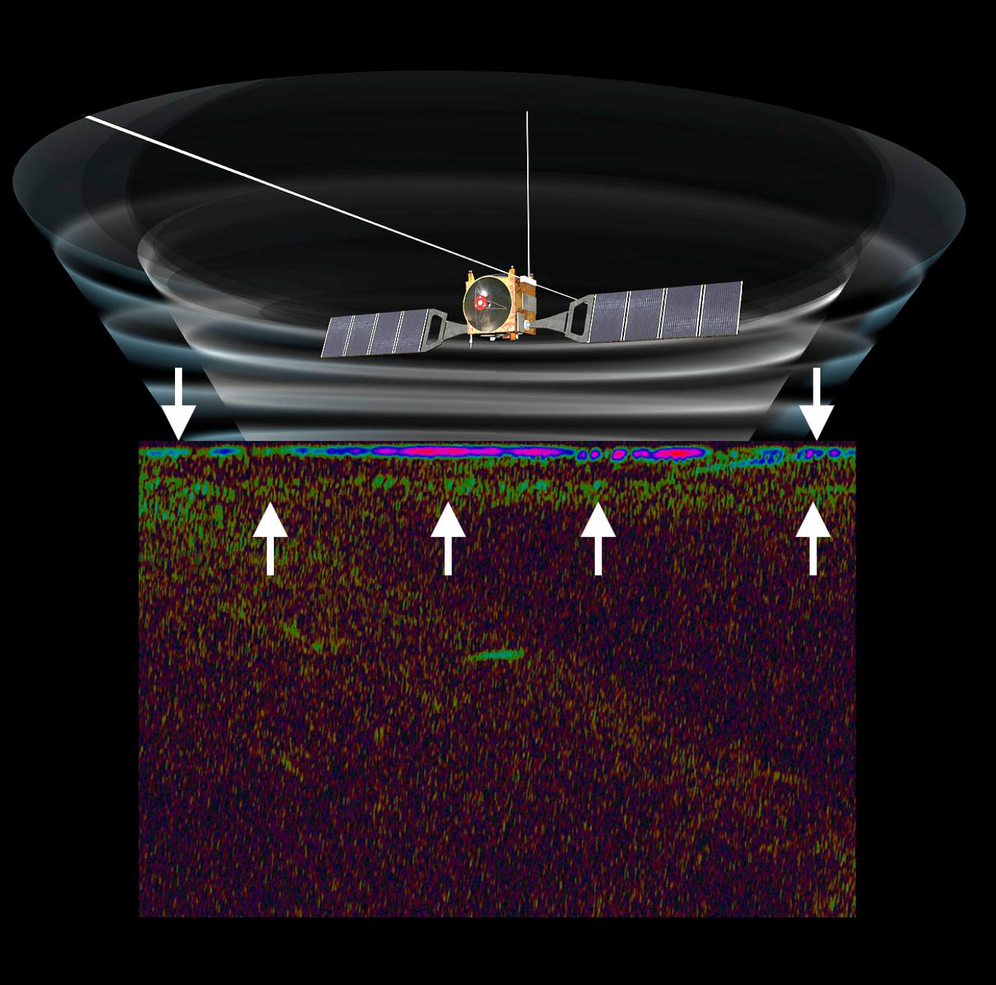
Radar detection of water under the south pole of Mars. Credit: ESA/NASA/JPL/ASI/Univ. Rome
So far, robotic missions have revealed considerable evidence of past water on Mars. These include dried-out river valleys and gigantic outflow channels discovered by orbiters, and evidence of mineral-rich soils that can only form in the presence of liquid water by rovers and landers. Early evidence from the ESA’s Mars Express probe has also showed that water-ice exists at the planet’s poles and is buried in the layers interspersed with dust.
However, scientists have long suspected that liquid water could exist beneath the polar ice caps, much in the same way that liquid water is believed to underlie glaciers here on Earth. In addition, the presence of salts on Mars could further reduce the melting point of subsurface water and keep it in a liquid state, despite the sub-zero temperatures present on both the surface and underground.
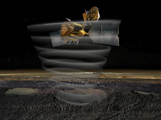
For many years, data from the Mars Express’Mars Advanced Radar for Subsurface and Ionosphere Sounding (MARSIS) instrument – which has been used to study the southern polar region – has remained inconclusive. Like all ground-penetrating radar, this instrument relies on radar pulses to map surface topography and determine the properties of the materials that lie beneath the surface.
Luckily, after considerable analysis, the study team was able to develop new techniques that allowed them to collect enough high-resolution data to confirm the presence of liquid water beneath the southern ice cap. As Andrea Cicchetti, the MARSIS operations manager and a co-author on the new paper, indicated:
“We’d seen hints of interesting subsurface features for years but we couldn’t reproduce the result from orbit to orbit, because the sampling rates and resolution of our data was previously too low. We had to come up with a new operating mode to bypass some onboard processing and trigger a higher sampling rate and thus improve the resolution of the footprint of our dataset: now we see things that simply were not possible before.”
Water detection under the south pole of Mars. Credit: Context map: NASA/Viking; THEMIS background: NASA/JPL-Caltech/Arizona State University; MARSIS data: ESA/NASA/JPL/ASI/Univ. Rome; R. Orosei et al 2018
What they found was that the southern polar region is made of many layers of ice and dust down to a depth of about 1.5 km over a 200 km-wide area, and featured an anomalous area measuring 20-km wide. As Roberto Orosei, the principal investigator of the MARSIS experiment and lead author of the paper, explained in a recent ESA press release:
“This subsurface anomaly on Mars has radar properties matching water or water-rich sediments. This is just one small study area; it is an exciting prospect to think there could be more of these underground pockets of water elsewhere, yet to be discovered.”
After analyzing the properties of the reflected radar signals and taking into account the composition of the layered deposits and expected temperature profiles below the surface, the scientists concluded that the 20-km wide feature is an interface between the ice and a stable body of liquid water. For MARSIS to be able to detect such a patch of water, it would need to be at least several tens of centimeters thick.
These findings also raise the possibility of there being life on Mars, both now and in the past. This is based on research that found microbial life in Lake Vostok, which is located some 4 km (2.5 mi) below the ice in Antarctica. If life can thrive in salty, subglacial environments on Earth, then it is possible that they could survive on Mars as well. Determining if this is the case will be the purpose of existing and future missions to Mars.
The MARSIS instrument on the Mars Express is a ground penetrating radar sounder used to look for subsurface water and ice. Credit: ESA
As Dmitri Titov, one of the Mars Express project scientist, explained:
“The long duration of Mars Express, and the exhausting effort made by the radar team to overcome many analytical challenges, enabled this much-awaited result, demonstrating that the mission and its payload still have a great science potential. This thrilling discovery is a highlight for planetary science and will contribute to our understanding of the evolution of Mars, the history of water on our neighbour planet and its habitability.”
The Mars Express launched on June 2nd, 2003, and will celebrate 15 years in orbit of Mars by December 25th this year. In the coming years, it will be joined by the ESA’s ExoMars 2020 mission, NASA’s Mars 2020 Rover, and a number of other scientific experiments. These missions will pave the way for a potential crewed mission, which NASA is planning to mount by the 2030s.
If there is indeed liquid water to be found on Mars, it will go a long way towards facilitating future research and even an ongoing human presence on the surface. And if there is still life on Mars, the careful research of its ecosystems will help address the all-important question of how and when life emerged in the Solar System.
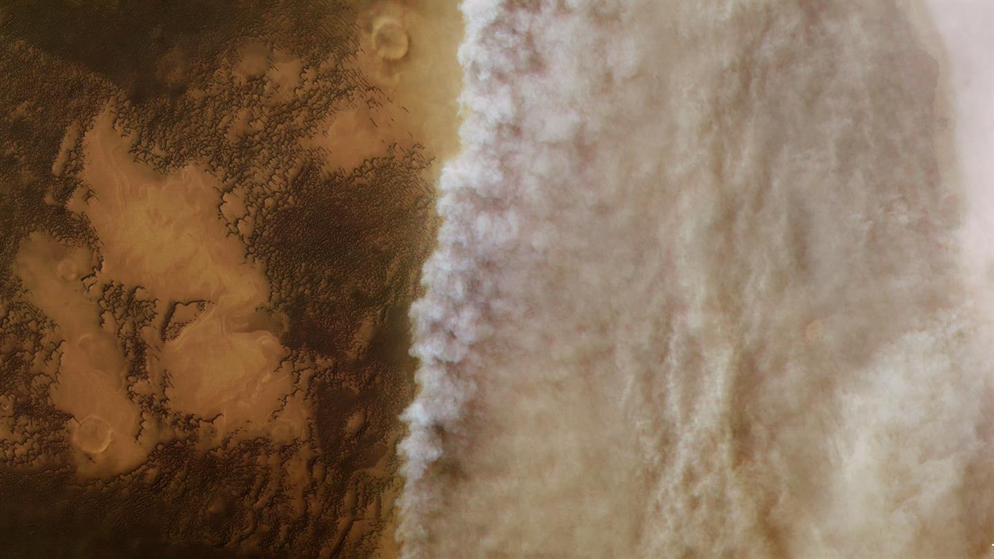
True color image of a storm front located near Utopia Planitia, near the northern polar ice cap of Mars. Credit: Credits: ESA/DLR/FU Berlin
The weather patterns on Mars are rather fascinating, owing to their particular similarities and differences with those of Earth. For one, the Red Planet experiences dust storms that are not dissimilar to storms that happen regularly here on Earth. Due to the lower atmospheric pressure, these storms are much less powerful than hurricanes on Earth, but can grow so large that they cover half the planet.
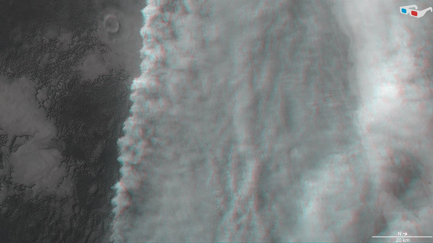
Recently, the ESA’s Mars Express orbiter captured images of the towering cloud front of a dust storm located close to Mars’ northern polar region. This storm, which began in April 2018, took place in the region known as Utopia Planitia, close to the ice cap at the Martian North Pole. It is one of several that have been observed on Mars in recent months, one which is the most severe to take place in years.
The images (shown above and below) were created using data acquired by the Mars Express‘ High Resolution Stereo Camera (HRSC). The camera system is operated by the German Aerospace Center (DLR), and managed to capture images of this storm front – which would prove to be the harbinger of the Martian storm season – on April 3rd, 2018, during its 18,039th orbit of Mars.
Anaglyph 3D image of the dust storm front forming above the subpolar plains in northern Mars. Credit: Credits: ESA/DLR/FU Berlin
This storm was one of several small-scale dust storms that have been observered in recent months on Mars. A much larger storm emerged further southwest in the Arabia Terra region, which began in May of 2018 and developed into a planet-wide dust storm within several weeks.
Dust storms occur on Mars when the southern hemisphere experiences summer, which coincides with the planet being closer to the Sun in its elliptical orbit. Due to increased temperatures, dust particles are lifted higher into the atmosphere, creating more wind. The resulting wind kicks up yet more dust, creating a feedback loop that NASA scientists are still trying to understand.
Since the southern polar region is pointed towards the Sun in the summer, carbon dioxide frozen in the polar cap evaporates. This has the effect of thickening the atmosphere and increases surface pressure, which enhances the storms by helping to suspend dust particles in the air. Though they are common and can begin suddenly, Martian dust storms typically stay localized and last only a few weeks.
While local and regional dust storms are frequent, only a few of them develop into global phenomena. These storms only occur every three to four Martian years (the equivalent of approximately 6 to 8 Earth years) and can persist for several months. Such storms have been viewed many times in the past by missions like Mariner 9 (1971), Viking I (1971) and the Mars Global Surveyor (2001).
This global map of Mars shows a growing dust storm as of June 6, 2018. The map was produced by the Mars Color Imager (MARCI) camera on NASA’s Mars Reconnaissance Orbiter spacecraft. The blue dot indicates the approximate location of Opportunity. Image Credit: NASA/JPL-Caltech/MSSS
In 2007, a large storm covered the planet and darkened the skies over where the Opportunity rover was stationed – which led to two weeks of minimal operations and no communications. The most recent storm, which began back in May, has been less intense, but managed to create a state of perpetual night over Opportunity’s location in Perseverance Valley.
As a result, the Opportunity team placed the rover into hibernation mode and shut down communications in June 2018. Meanwhile, NASA’s Curiosity rover continues to explore the surface of Mars, thanks to its radioisotope thermoelectric generator (RTG), which does not rely on solar panels. By autumn, scientists expect the dust storm will weaken significantly, and are confident Opportunity will survive.
Understanding how global storms form and evolve on Mars will be critical for future solar-powered missions. It will also come in handy when crewed missions are conducted to the planet, not to mention space tourism and colonization!
This image of Deimos and Saturn was taken by the Super Resolution Channel of Mars Express’ High Resolution Stereo Camera. Credit: ESA/DLR/FU Berlin
The ESA’s Mars Express probe has been studying Mars and its Moons for many years. While there are several missions currently in orbit around Mars, Mars Express‘s near-polar elliptical orbit gives it some advantages over the others. For one, its orbital path takes it closer to Phobos than any other spacecraft, which allows it to periodically observe the moon from distances of around 150 km (93 mi).
Because of this, the probe is in an ideal position to study Mars’ moons and capture images of them. On occasion, this allows for some interesting photo opportunities. For example, in November of 2017, while taking pictures of Phobos and Deimos, the probe spotted Saturn in the background. This fortuitous event led to the creation of some beautiful images, which were put together to produce a video.
Since 2003, Mars Express has been studying Phobos and Deimos in the hopes of learning more about these mysterious objects. While it has learned much about their size, appearance and position, much remains unknown about their composition, how and where they formed, and what their surface conditions are like. To answer these questions, the probe has been conducting regular flybys of these moons and taking pictures of them.
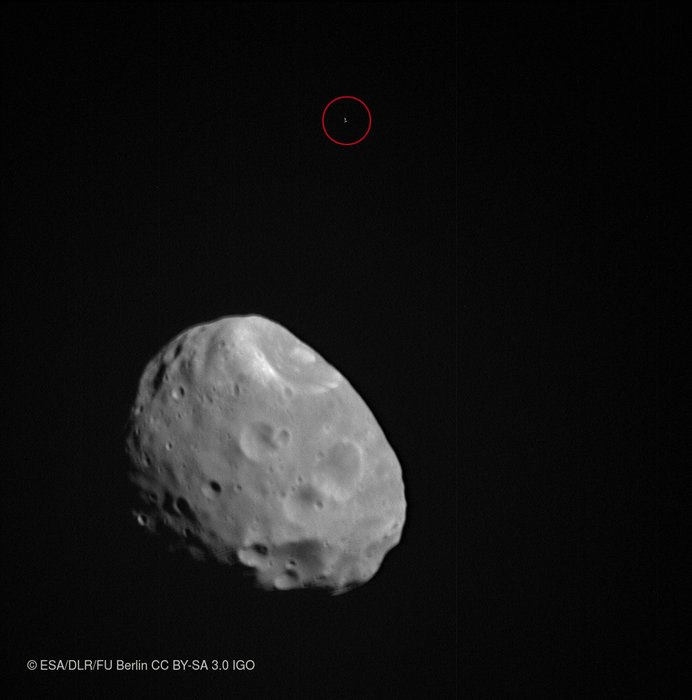
Phobos and background star (circled in red). Credit: ESA/DLR/FU Berlin
The video that was recently released by the ESA combines 30 such images which show Phobos passing through the frame. In the background, Saturn is visible as a small ringed dot, despite being roughly 1 billion km away. The images that were used to create this video were taken by the probes High Resolution Stereo Camera on November 26th, 2016, while the probe was traveling at a speed of about 3 km/s.
This photobomb was not unexpected, since the Mars Express repeatedly uses background reference stars and other bodies in the Solar System to confirm positions of the moons in the sky. In so doing, the probe is able to calculate the position of Phobos and Deimos with an accuracy of up to a few kilometers. The probes ideal position for capturing detailed images has also helped scientists to learn more about the surface features and structure of the two moons.
For instance, the pictures taken during the probe’s close flybys of Phobos showed its bumpy, irregular and dimpled surface in detail.The moon’s largest impact crater – the Stickney Crater – is also visible in one of the frames. Measuring 9 km ( mi) in diameter, this crater accounts for a third of the moon’s diameter, making it one the largest impact craters relative to body size in the Solar System.
In another image, taken on January 15th, 2018, Deimos is visible as an irregular and partially shadowed body in the foreground, while the delicate rings of Saturn are just visible encircling the small dot in the background (see below). In addition, Mars Express also obtained images of Phobos set against a reference star on January 8th, 2018 (see above) and close-up images of Phobos’ pockmarked surface on September 12th, 2017.
This image of Deimos and Saturn was taken by the Super Resolution Channel of Mars Express’ High Resolution Stereo Camera. Credit: ESA/DLR/FU Berlin
In the future, the Mars Express probe is expected to reveal a great deal more about Mars’ system of moons. In addition to the enduring questions of their origins, formation and composition, there are also questions about where future missions could land in order to study the surface directly. In particular, Phobos has been considered for a possible landing and sample-return mission.
Because of its nearness to Mars and the fact that one side is always facing towards the planet, the moon could make for an ideal location for a permanent observation post. This post would allow for the long-term study of the Martian surface and atmosphere, could act as a communications relay for other spacecraft, and could even serve as a base for future missions to the surface.
If and when such a mission to Phobos becomes a reality, it is the Mars Express probe that will determine where the ideal landing site would be. In essence, by studying the Martian moons to learning more about them, Mars Express is helping to prepare future missions to the Red Planet.
Be sure to check out the time-lapse video of Phobos and Saturn, courtesy of the ESA:
A new paper suggests hydrogen-possibly water ice-in the Medusa Fossae area of Mars, which is in an equatorial region of the planet to the lower left in this view. Image Credit: Steve Lee (University of Colorado), Jim Bell (Cornell University), Mike Wolff (Space Science Institute), and NASA
Finding a source of Martian water – one that is not confined to Mars’ frozen polar regions – has been an ongoing challenge for space agencies and astronomers alike. Between NASA, SpaceX, and every other public and private space venture hoping to conduct crewed mission to Mars in the future, an accessible source of ice would mean the ability to manufacture rocket fuel on sight and provide drinking water for an outpost.
So far, attempt to locate an equatorial source of water ice have failed. But after consulting old data from the longest-running mission to Mars in history – NASA’s Mars Odyssey spacecraft – a team of researchers from the John Hopkins University Applied Physics Laboratory (JHUAPL) announced that they may have found evidence of a source of water ice in the Medusae Fossae region of Mars.
This region of Mars, which is located in the equatorial region, is situated between the highland-lowland boundary near the Tharsis and Elysium volcanic areas. This area is known for its formation of the same name, which is a soft deposit of easily-erodible material that extends for about 5000 km (3,109 mi) along the equator of Mars. Until now, it was believed to be impossible for water ice to exist there.
Artist’s conception of the Mars Odyssey spacecraft. Credit: NASA/JPL
However, a team led by Jack Wilson – a post-doctoral researcher at the JHUAPL – recently reprocessed data from the Mars Odyssey spacecraft that showed unexpected signals. This data was collected between 2002 and 2009 by the mission’s neutron spectrometer instrument. After reprocessing the lower-resolution compositional data to bring it into sharper focus, the team found that it contained unexpectedly high signals of hydrogen.
To bring the information into higher-resolution, Wilson and his team applied image-reconstruction techniques that are typically used to reduce blurring and remove noise from medical and spacecraft imaging data. In so doing, the team was able to improve the data’s spatial resolution from about 520 km (320 mi) to 290 km (180 mi). Ordinarily, this kind of improvement could only be achieved by getting the spacecraft much closer to the surface.
“It was as if we’d cut the spacecraft’s orbital altitude in half,” said Wilson, “and it gave us a much better view of what’s happening on the surface.” And while the neutron spectrometer did not detect water directly, the high abundance of neutrons detected by the spectrometer allowed the research team to calculate the abundance of hydrogen. At high latitudes on Mars, this is considered to be a telltale sign of water ice.
The first time the Mars Odyssey spacecraft detected abundant hydrogen was in 2002, which appeared to be coming from subsurface deposits at high latitudes around Mars. These findings were confirmed in 2008, when NASA’s Phoenix Lander confirmed that the hydrogen took the form of water ice. However, scientists have been operating under the assumption that at lower latitudes, temperatures are too high for water ice to exist.
This artist’s concept of the Mars Reconnaissance Orbiter highlights the spacecraft’s radar capability. Credit: NASA/JPL
These scans have suggested that there was either low-density volcanic deposits or water ice below the surface, though the results seemed more consistent with their being no water ice to speak of. As Wilson indicated, their results lend themselves to more than one possible explanation, but seem to indicate that water ice could part of the subsurface’s makeup:
“[I]f the detected hydrogen were buried ice within the top meter of the surface. there would be more than would fit into pore space in soil… Perhaps the signature could be explained in terms of extensive deposits of hydrated salts, but how these hydrated salts came to be in the formation is also difficult to explain. So for now, the signature remains a mystery worthy of further study, and Mars continues to surprise us.”
Given Mars’ thin atmosphere and the temperature ranges that are common around the equator – which get as high as 308 K (35 °C; 95 °F) by midday during the summer – it is a mystery how water ice could be preserved there. The leading theory though is that a mixture of ice and dust was deposited from the polar regions in the past. This could have happened back when Mars’ axial tilt was greater than it is today.
The MARSIS instrument on the Mars Express is a ground penetrating radar sounder used to look for subsurface water and ice. Credit: ESA
However, those conditions have not been present on Mars for hundreds of thousands or even millions of years. As such, any subsurface ice that was deposited there should be long gone by now. There is also the possibility that subsurface ice could be shielded by layers of hardened dust, but this too is insufficient to explain how water ice could have survived on the timescales involved.
In the end, the presence of abundant hydrogen in the Medusae Fossae region is just another mystery that will require further investigation. The same is true for deposits of water ice in general around the equatorial region of Mars. Such deposits mean that future missions would have a source of water for manufacturing rocket fuel.
This would shave billions of dollars of the costs of individual mission since spacecraft would not need to carry enough fuel for a return trip with them. As such, interplanetary spacecraft could be manufactured that would be smaller, lighter and faster. The presence of equatorial water ice could also be used to provide a steady supply of water for a future base on Mars.
Crews could be rotated in and out of this base once every two years – in a way that is similar to what we currently do with the International Space Station. Or – dare I say it? – a local source of water could be used to supply drinking, sanitation and irrigation water to eventual colonists! No matter how you slice it, finding an accessible source of Martian water is critical to the future of space exploration as we know it!
Mars Express' view of Meridiani Planum. Credits: ESA/DLR/FU Berlin (G. Neukum)
It is a well-known fact that today, Mars is a very cold and dry place. Whereas the planet once had a thicker atmosphere that allowed for warmer temperatures and liquid water on its surface, the vast majority of water there today consists of ice that is located in the polar regions. But for some time, scientists have speculated that there may be plenty of water in subsurface ice deposits.
If true, this water could be accessed by future crewed missions and even colonization efforts, serving as a source of rocket fuel and drinking water. Unfortunately, a new study led by scientists from the Smithsonian Institution indicates that the subsurface region beneath Meridiani Planum could be ice-free. Though this may seem like bad news, the study could help point the way towards accessible areas of water ice on Mars.
Artist’s impression of a global view of Mars, centered on the Meridiani Planum region. Credit: Air and Space Museum/Smithsonian Institution
Despite being one of the most intensely explored regions on Mars, particularly by missions like the Opportunity rover, the subsurface structure of Meridiani Planum has remained largely unknown. To remedy this, the science team led by Dr. Watters examined data that had been collected by the Mars Advanced Radar for Subsurface and Ionospheric Sounding (MARSIS) instrument aboard the ESA’s Mars Express orbiter.
Developed by researchers at the University of Rome in partnership with NASA’s Jet Propulsion Laboratory (and with the help of private contractors), this device used low-frequency radio pulses to study Mars’ ionosphere, atmosphere, surface, and interior structure. The way these pulses penetrated into certain materials and were reflected back to the orbiter was then used to determine the bulk density and compositions of those materials.
After examining the Meridiani Planum region, the Mars Express probe obtained readings that indicated that the subsurface area had a relatively low dielectric constant. In the past, these kinds of readings have been interpreted as being due to the presence of pure water ice. And in this case, the readings seemed to indicate that the subsurface was made up of porous rock that was filled with water ice.
However, with the help of newly-derived compaction models for Mars, the team concluded that these signals could be the result of ice-free, porous, windblown sand (aka. eolian sands). They further theorized that the Meridiani Planum region, which is characterized by some rather unique physiographic and hydrologic features, could have provided an ideal sediment trap for these kinds of sands.
Artist’s impression of the Mars Express rover, showing radar returns from its MARSIS instrument. Credit: ESA/NASA/JPL/KU/Smithsonian
“The relatively low gravity and the cold, dry climate that has dominated Mars for billions of years may have allowed thick eolian sand deposits to remain porous and only weakly indurated,” they concluded. “Minimally compacted sedimentary deposits may offer a possible explanation for other nonpolar region units with low apparent bulk dielectric constants.”
“It’s very revealing that the low dielectric constant of the Meridiani Planum deposits can be explained without invoking pore-filling ice. Our results suggest that caution should be exercised in attributing non-polar deposits on Mars with low dielectric constants to the presence of water ice.”
On its face, this would seem like bad news to those who were hoping that the equatorial regions on Mars might contain vast deposits of accessible water ice. It has been argued that when crewed missions to Mars begin, this ice could be accessed in order to supply water for surface habitats. In addition, ice that didn’t need to come from there could also be used to manufacture hydrazine fuel for return missions.
This would reduce travel times and the cost of mounting missions to Mars considerably since the spacecraft would not need to carry enough fuel for the entire journey, and would therefore be smaller and faster. In the event that human beings establish a colony on Mars someday, these same subsurface deposits could also used for drinking, sanitation, and irrigation water.
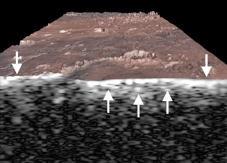
A subsurface view of Miyamoto crater in Meridiani Planum from the MARSIS radar sounder. . Credit: ESA/NASA/JPL/KU/Smithsonian
As such, this study – which indicates that low dielectric constants could be due to something other than the presence of water ice – places a bit of a damper on these plans. However, understood in context, it provides scientists with a means of locating subsurface ice. Rather than ruling out the presence of subsurface ice away from the polar regions entirely, it could actually help point the way to much-needed deposits.
One can only hope that these regions are not confined to the polar regions of the planet, which would be far more difficult to access. If future missions and (fingers crossed!) permanent outposts are forced to pump in their water, it would be far more economical to do from underground sources, rather than bringing it in all the way from the polar ice caps.
Colour-coded topographic view of the Colles Nili region, showing the relative heights and depths of terrain. Credit: ESA/DLR/FU Berlin
In the northern hemisphere of Mars, between the planet’s southern highlands and the northern lowlands, is a hilly region known as Colles Nilli. This boundary-marker is a very prominent feature on Mars, as it is several kilometers in height and surrounded by the remains of ancient glaciers.
And thanks to the Mars Express mission, it now looks like this region is also home to some buried glaciers. Such was the conclusion after the orbiting spacecraft took images that revealed a series of eroded blocks along this boundary, which scientists have deduced are chunks of ice that became buried over time.
The Mars Express images show a plethora of these features along the north-south boundary. They also reveal several features that hint at the presence of buried ice and erosion – such as layered deposits as well as ridges and troughs. Similar features are also found in nearby impact craters. All of these are believed to have been caused by an ancient glacier as it retreated several hundred million years ago.
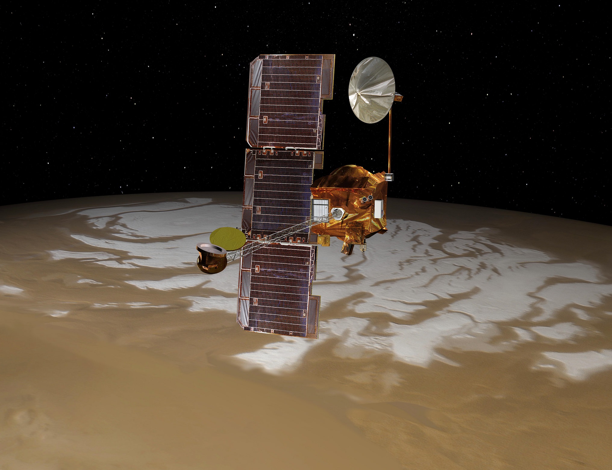
Artist’s impression of the Mars Express spacecraft in orbit. Credit: ESA/Medialab
It is further reasoned that these remaining ice deposits were covered by debris that was deposited from the plateau as it eroded. Wind-borne dust was also deposited over time, which is believed to be the result of volcanic activity. This latter source is evidenced by steaks of dark material deposited around the blocks, as well as dark sand dunes spotted within the impact craters.
Similar features are believed to exist within many boundary regions on Mars, and are believed to represent periods of glaciation that took place over the course of eons. And this is not the first time buried glaciers have been spotted on Mars.
For instance, back in 2008, the Mars Reconnaissance Orbiter (MRO) used its ground-penetrating radar to locate water ice under blankets or rocky debris, and at latitudes far lower than any that had been previously identified. At the time, this information shed light on a long-standing mystery about Mars, which was the presence of what are called “aprons”.
These gently-sloping rocky deposit, which are found at the bases of taller features, were first noticed by NASA’s Viking orbiters during the 1970s. A prevailing theory has been that these aprons are the result of rocky debris lubricated by small amounts of ice.
Artist’s impression of the separation of the ExoMars entry, descent and landing demonstrator module (Schiaparelli) from the Trace Gas Orbiter (TGO). Credit: ESA/ATG medialab
Combined with this latest info taken from the northern hemisphere, it would appear that there is plenty of ice deposits all across the surface of Mars. The presence (and prevalence) of these icy remnants offer insight into Mars’ geological past, which – like Earth – involved some “ice ages”.
The Mars Express mission has been actively surveying the surface of Mars since 2003. On October 19th, it will be playing a vital role as the Exomars mission inserts itself into Martian orbit and the Schiaparelli lander makes its descent and landing on the Martian surface.
Alongside the MRO and the ExoMars Orbiter, it will be monitoring signals from the lander to confirm its safe arrival, and will relay information sent from the surface during the course of its mission.
The ESA will be broadcasting this event live. And given that this mission will be the ESA’s first robotic lander to reach Mars, it should prove to be an exciting event!
Image taken by the HiRISE camera on NASA's Mars Reconnaissance Orbiter, showing Earth and the Moon. Credit: NASA/JPL
Modern astronomy and space exploration has blessed us with a plethora of wonderful images. Whether they were images of distant planets, stars and galaxies taken by Earth-based telescopes, or close-ups of planets or moons in our own Solar System by spacecraft, there has been no shortage of inspiring pictures. But what would it look like to behold planet Earth from another celestial body?
We all remember the breathtaking photos taken by the Apollo astronauts that showed what Earth looked like from the Moon. But what about our next exploration destination, Mars? With all the robotic missions on or in orbit around the Red Planet, you’d think that there would have been a few occasions where they got a good look back at Earth. Well, as it turn out, they did!
Pictures from Space:
Pictures of Earth have been taken by both orbital missions and surface missions to Mars. The earliest orbiters, which were part of the Soviet Mars and NASA Mariner programs, began arriving in orbit around Mars by 1971. NASA’s Mariner 9 probe was the first to establish orbit around the planet’s (on Nov. 14, 1971), and was also the first spacecraft to orbit another planet.
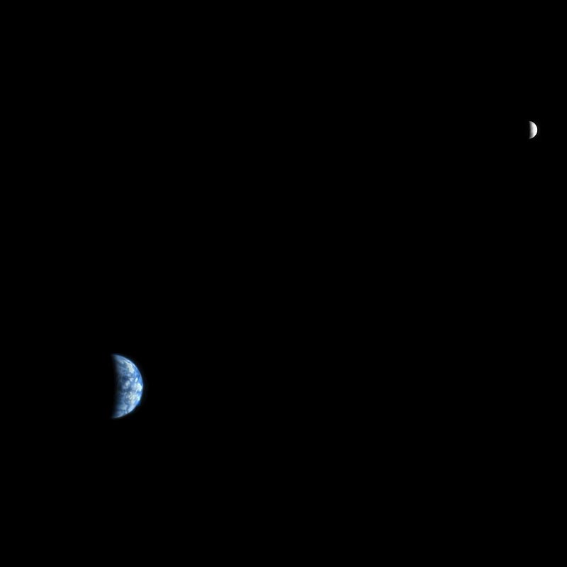
Image of Earth and Moon, taken by the Mars Orbiter Camera of Mars Global Surveyor on May 8 2003. Credit: NASA/JPL/Malin Space Science Systems
The first orbiter to capture a picture of Earth from Mars, however, was the Mars Global Surveyor, which launched in Nov. 7th, 1996, and arrived in orbit around the planet on Sept. 12th, 1997. In the picture (shown above), which was taken in 2003, we see Earth and the Moon appearing closely together.
At the time the picture was taken, the distance between Mars and Earth was 139.19 million km (86.49 million mi; 0.9304 AU) while the distance between Mars and the Moon was 139.58 million km (86.73 million mi; 0.9330 AU). Interestingly enough, this is what an observer would see from the surface of Mars using a telescope, whereas a naked-eye observer would simply see a single point of light.
Usually, the Earth and Moon are visible as two separate points of light, but at this point in the Moon’s orbit they were too close to resolve with the naked eye from Mars. If you look closely at Earth, you can just make out the shape of South America.
Earth and the Moon, captured by the Mars Express spacecraft on July 3, 2003. Credit: ESA
The picture above was snapped by the Mars Express’s High Resolution Stereo Camera (HRSC) on the ESA’s Mars Express probe. It was also taken in 2003, and is similar in that it shows the Earth and Moon together. However, in this image, we see the two bodies at different points in their orbit – which is why the Moon looks like its farther away. Interestingly enough, this image was actually part of the first data sets to be sent by the spacecraft.
The next orbiter to capture an image of Earth from Mars was the Mars Reconnaissance Orbiter (MRO), which was launched in August of 2005 and attained Martian orbit on March 10th, 2006. When the probe reached Mars, it joined five other active spacecraft that were either in orbit or on the surface, which set a record for the most operational spacecraft in the vicinity of Mars at the same time.
In the course of its mission – which was to study Mars’ surface and weather conditions, as well as scout potential landing sites – the orbiter took many interesting pictures. The one below was taken on Oct. 3rd, 2007, which showed the Earth and the Moon in the same frame.
Image of Earth and the Moon taken by the Mars Reconnaissance Orbiter’s High Resolution Imaging Science Experiment (HiRISE) on Oct. 3rd, 2007. Credit: NASA/JPL
Pictures from the Surface:
As noted already, pictures of Earth have also been taken by robotic missions to the surface of Mars. This has been the case for as long as space agencies have been sending rovers or landers that came equipped with mobile cameras. The earliest rovers to reach the surface – Mars 2 and Mars 3– were both sent by the Soviets.
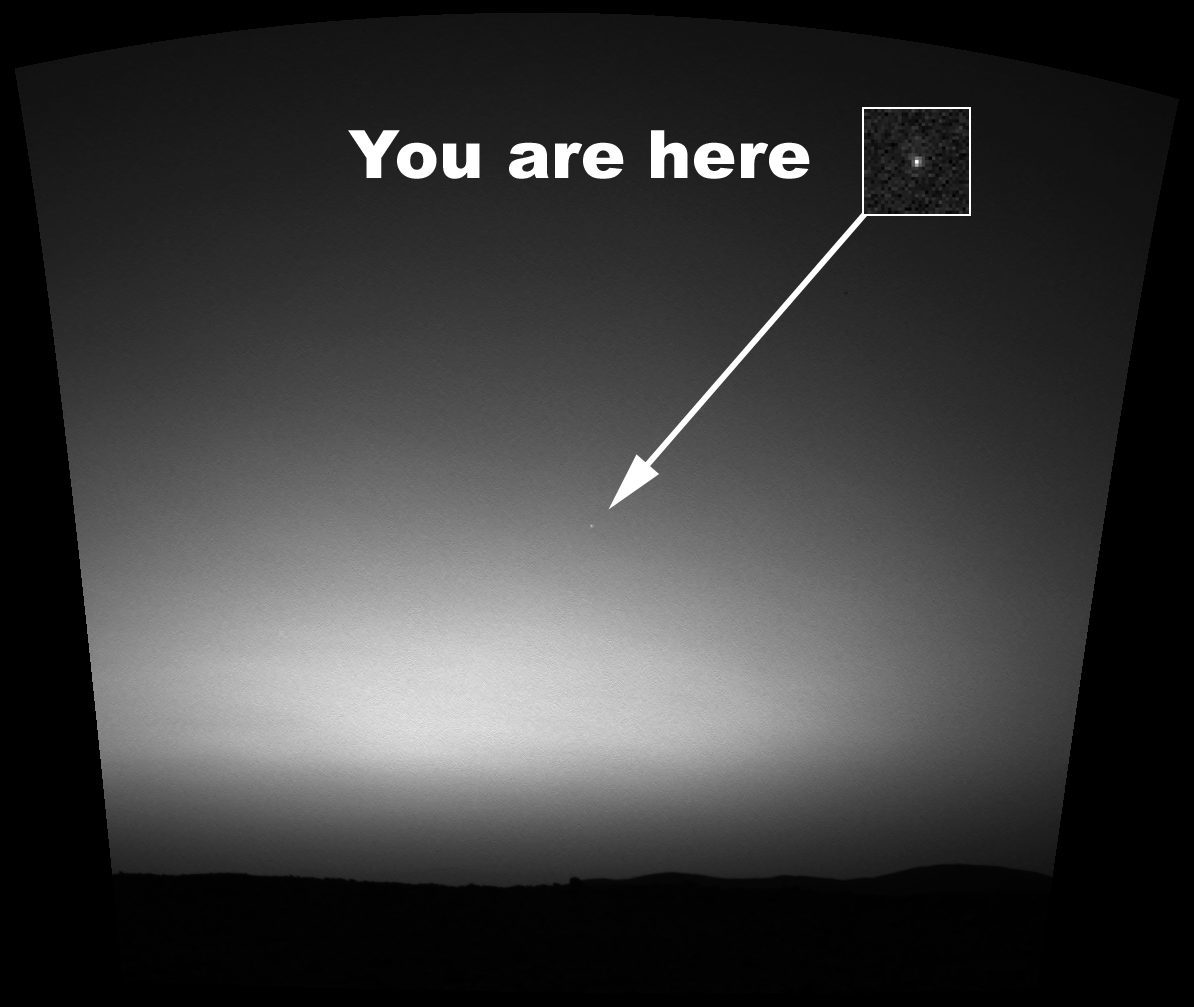
However, it was not until early March of 2004, while taking photographs of the Martian sky, that the Spirit rover became the first to snap a picture of Earth from the surface of another planet. This image was caught while the rover was attempting to observe Mars’ moon Deimos making a transit of the Sun (i.e. a partial eclipse).
This is something which happens quite often given the moon’s orbital period of about 30 hours. However, on this occasion, the rover managed to also capture a picture of distant Earth, which appeared as little more than a particularly bright star in the night sky.
Earth seen from Mars shortly before daybreak. This is the first image of the Earth from the surface of another planet. Credit: NASA/JPL
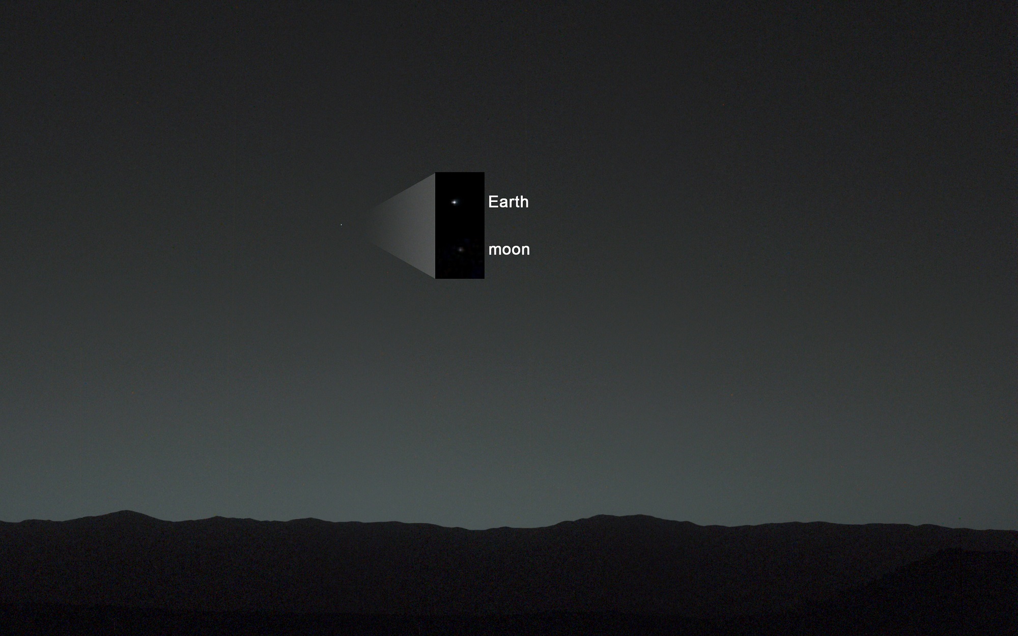
The next rover to snap an image of Earth from the Martian surface was Curiosity, which began sending back many breathtaking photos even before it landed on Aug. 6th, 2012. And on Jan. 31st, 2014 – almost a year and a half into its mission – the rover managed to capture an image of both Earth and the Moon in the night sky.
In the image (seen below), Earth and the Moon are just visible as tiny dots to the naked eye – hence the inset that shows them blown up for greater clarity. The distance between Earth and Mars when Curiosity took the photo was about 160 million km (99 million mi).
Earth has been photographed from Mars several times now over the course of the past few decades. Each picture has been a reminder of just how far we’ve come as a species. It also provides us with a preview of what future generations may see when looking out their cabin window, or up at the night sky from other planets.
Image taken by NASA’s Curiosity Mars rover, showing Earth and the Moon shining in the night sky. Credit: NASA/JPL
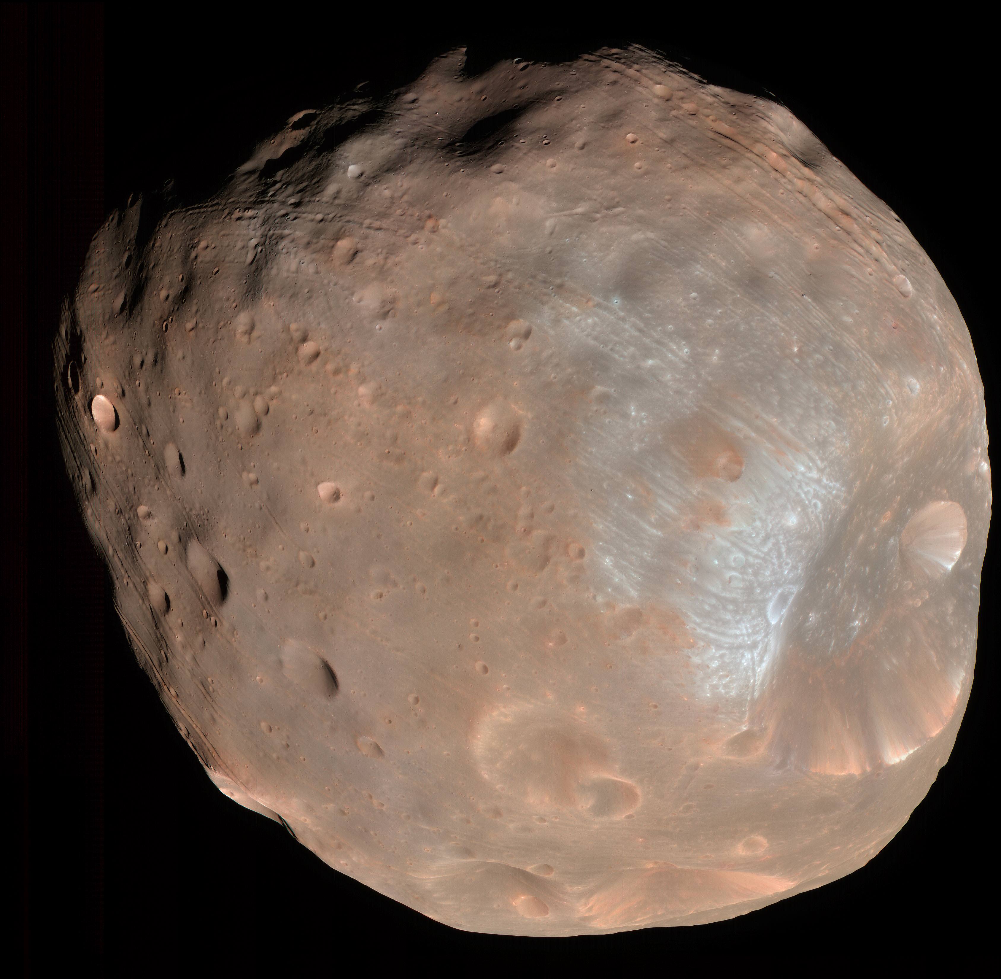
Mars moon Phobos sports linear grooves and crater chains whose origin has never explained. Credit: NASA/JPL
Mars’ natural satellites – Phobos and Deimos – have been a mystery since they were first discovered. While it is widely believed that they are former asteroids that were captured by Mars’ gravity, this remains unproven. And while some of Phobos’ surface features are known to be the result of Mars’ gravity, the origin of its linear grooves and crater chains (catenae) have remained unknown.
But thanks to a new study by Erik Asphaug of Arizona State University and Michael Nayak from the University of California, we may be closer to understanding how Phobos’ got its “groovy” surface. In short, they believe that re-accretion is the answer, where all the material that was ejected when meteors impacted the moon eventually returned to strike the surface again.
Naturally, Phobos’ mysteries extend beyond its origin and surface features. For instance, despite being much more massive than its counterpart Deimos, it orbits Mars at a much closer distance (9,300 km compared to over 23,000 km). It’s density measurements have also indicated that the moon is not composed of solid rock, and it is known to be significantly porous.
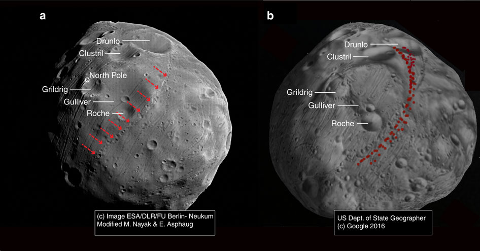
Image of Phobos showing the observed catena of interest (left) and reimpact map for a primary impact at Grildrig (right). Credit: ESA/Mars ExpressBecause of this proximity, it is subject to a lot of tidal forces exerted by Mars. This causes its interior, a large portion of which is believed to consist of ice, to flex and stretch. This action, it has been theorized, is what is responsible for the stress fields that have been observed on the moon’s surface.
However, this action cannot account for another common feature on Phobos, which are the striation patterns (aka. grooves) that run perpendicular to the stress fields. These patterns are essentially chains of craters that typically measure 20 km (12 mi) in length, 100 – 200 meters (330 – 660 ft) in width, and usually 30 m (98 ft) in depth.
In the past, it was assumed that these craters were the result of the same impact that created Stickney, the largest impact crater on Phobos. However, analysis from the Mars Express mission revealed that the grooves are not related to Stickney. Instead, they are centered on Phobos’ leading edge and fade away the closer one gets to its trailing edge.
For the sake of their study, which was recently published in Nature Communications, Asphaug and Nayak used computer modeling to simulate how other meteoric impacts could have created these crater patterns, which they theorized were formed when the resulting ejecta circled back and impacted the surface in other locations.
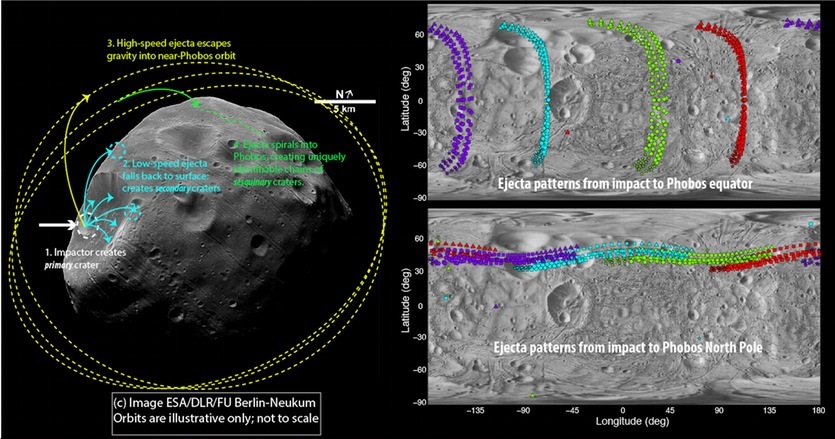
Image showing the Stickney crater (left) and how ejecta from an impact can form patterns (right) and crater chains (catenae). Credit: ESA/DLR/FU Berlin-Neukum
As Dr. Asphaug told Universe Today via email, their work was the result of a meeting of minds that spawned an interesting theory:
“Dr. Nayak had been studying with Prof. Francis Nimmo (of UCSC), the idea that ejecta could swap between the Martian moons. So Mikey and I met up to talk about that, and the possibility that Phobos could sweep up its own ejecta. Originally I had been thinking that seismic events (triggered by impacts) might cause Phobos to shed material tidally, since it’s inside the Roche limit, and that this material would thin out into rings that would be reaccreted by Phobos. That still might happen, but for the prominent catenae the answer turned out to be much simpler (after a lot of painstaking computations) – that crater ejecta is faster than Phobos’ escape velocity, but much slower than Mars orbital velocity, and much of it gets swept up after several co-orbits about Mars, forming these patterns.”
Basically, they theorized that if a meteorite stuck Phobos in just the right place, the resulting debris could have been thrown off into space and swept up later as Phobos swung back around mars. Thought Phobos does not have sufficient gravity to re-accrete ejecta on its own, Mars’ gravitational pull ensures that anything thrown off by the moon will be pulled into orbit around it.
Once this debris is pulled into orbit around Mars, it will circle the planet a few times until it eventually falls into Phobos’ orbital path. When that happens, Phobos will collide with it, triggering another impact that throws off more ejecta, thus causing the whole process to repeat itself.
The streaked and stained surface of Phobos, with the Stickney crater shown in the center. Credit: NASA/JPL/Mars Express
In the end, Asphaug and Nayak concluded that if an impact hit Phobos at a certain point, the subsequent collisions with the resulting debris would form a chain of craters in discernible patterns – possibly within days. Testing this theory required some computer modeling on an actual crater.
Using Grildrig (a 2.6 km crater near Phobos’ north pole) as a reference point, their model showed that the resulting string of craters was consistent with the chains that have been observed on Phobos’ surface. And while this remains a theory, this initial confirmation does provide a basis for further testing.
“The initial main test of the theory is that the patterns match up, ejecta from Grildrig for example,” said Asphaug. “But it’s still a theory. It has some testable implications that we’re now working on.”
In addition to offering a plausible explanation of Phobos’ surface features, their study is also significant in that it is the first time that sesquinary craters (i.e. craters caused by ejecta that went into orbit around the central planet) were traced back to their primary impacts.
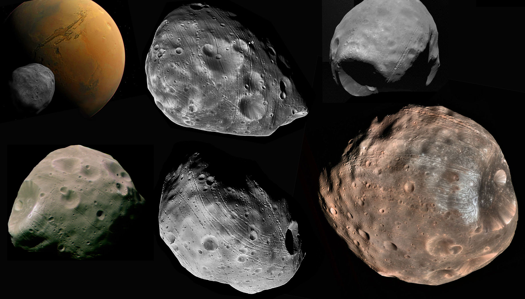
Mosaic of space images showing the many “faces” of Mars inner moon, Phobos. Credit: NASA
In the future, this kind of process could prove to be a novel way to assess the surface characteristics of planets and other bodies – such as the heavily cratered moons of Jupiter and Saturn. These findings will also help us to learn more about Phobos history, which in turn will help shed light on the history of Mars.
“[It] expands our ability to make cross-cutting relationships on Phobos that will reveal the sequence of geologic history,” Asphaug added. “Since Phobos’ geologic history is slaved to the tidal dissipation of Mars, in learning the timescale of Phobos geology we learn about the interior structure of Mars”
And all of this information is likely to come in handy when it comes time for NASA to mount crewed missions to the Red Planet. One of the key steps in the proposed “Journey to Mars” is a mission to Phobos, where the crew, a Mars habitat, and the mission’s vehicles will all be deployed in advance of a mission to the Martian surface.
Learning more about the interior structure of Mars is a goal shared by many of NASA’s future missions to the planet, which includes NASA’s InSight Lander (schedules for launch in 2018). Shedding light on Mars geology is expected to go a long way towards explaining how the planet lost its magnetosphere, and hence its atmosphere and surface water, billions of years ago.