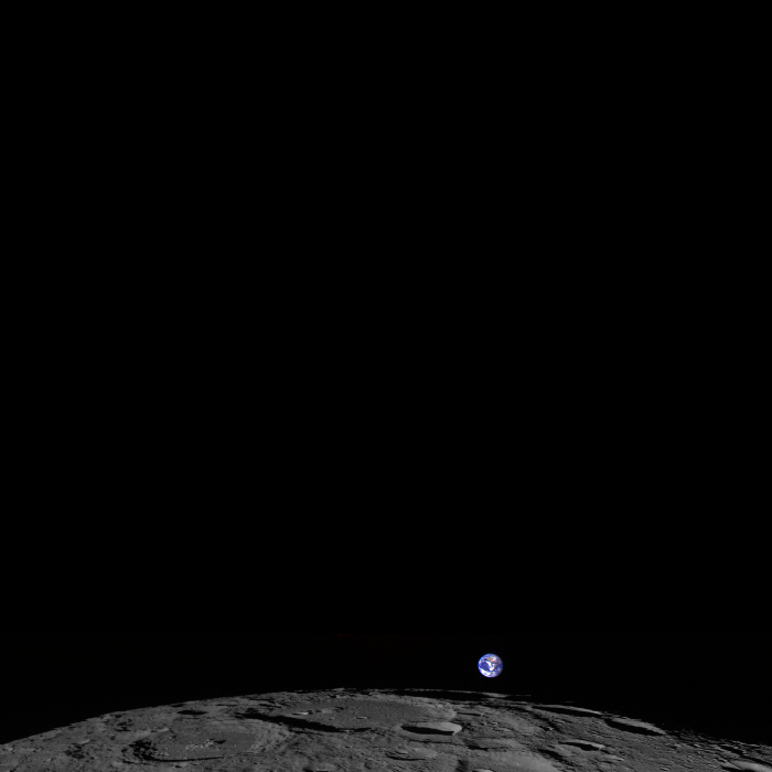
The Moon, tiny Earth and the vastness of space,as seen by the Lunar Reconnaissance Orbiter Wide Angle Camera (WAC). Credit: NASA/GSFC/Arizona State University.
That’s Earth. That’s us. Way off in the distance as a fairly small, blue and swirly white sphere. This is the newest so-called “Earthrise” image, and it was taken on February 1, 2014 by the Lunar Reconnaissance Orbiter.
“LRO experiences twelve earthrises every day, however LROC is almost always busy imaging the lunar surface so only rarely does an opportunity arise such that LROC can capture a view of the Earth,” wrote LROC Principal Investigator Mark Robinson on the instrument’s website. “On the first of February of this year LRO pitched forward while approaching the north pole allowing the LROC WAC to capture the Earth rising above Rozhdestvenskiy crater (180-km diameter).”
Robinson went on to explain that the Earth is a color composite from several frames and the colors are very close to what the average person would see if they were looking back at Earth themselves from lunar orbit. “Also, in this image the relative brightness between the Earth and the Moon is correct, note how much brighter the Earth is relative to the Moon,” Robinson said.
Gorgeous.
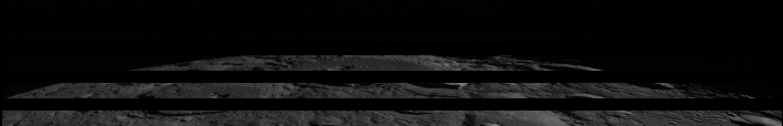
Below is a gif image that demonstrates how images are combined over several orbits to create a full image from the Wide Angle Camera.
A gif image showing the “venetian blind” banding demonstrates how a WAC image is built up frame-by-frame. The gaps between the frames are due to the real separation of the WAC filters on the CCD. Credit: NASA/GSFC/Arizona State University.
The frames were acquired at two second intervals, so the total time to collect the sequence was 5 minutes. The video is faster than reality by a factor of about 20.
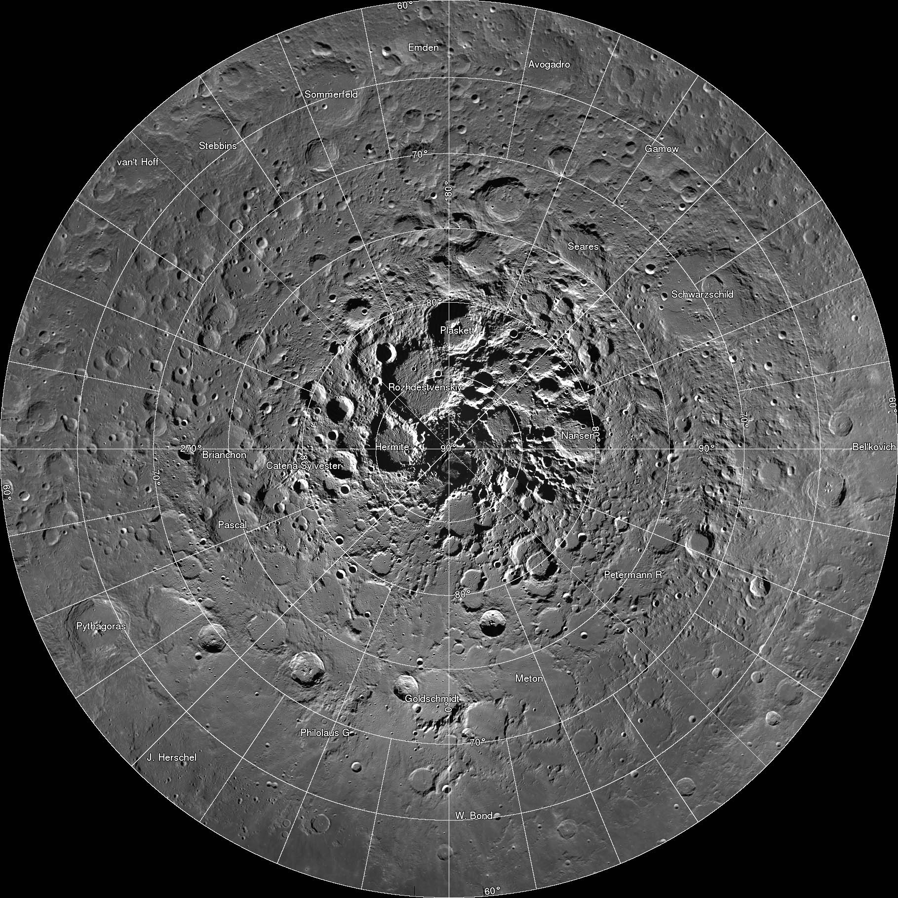
A new interactive mosaic from NASA's Lunar Reconnaissance Orbiter covers the north pole of the moon from 60 to 90 degrees north latitude at a resolution of 6-1/2 feet (2 meters) per pixel. Close-ups of Thales crater (right side) zoom in to reveal increasing levels of detail.
Image Credit: NASA/GSFC/Arizona State University
OMG – breathtaking! That was my reaction when I clicked on this incredible new interactive map of the moon’s north polar region. Be prepared to be amazed. It took four years and 10,581 images for the LROC (Lunar Reconnaissance Orbiter Camera) team to assemble what’s believed to be the largest publicly available image mosaic in existence. With over 650 gigapixels of data at a resolution of 2 meters per pixel, you’ll feel like you’re dropping in by parachute to the lunar surface.
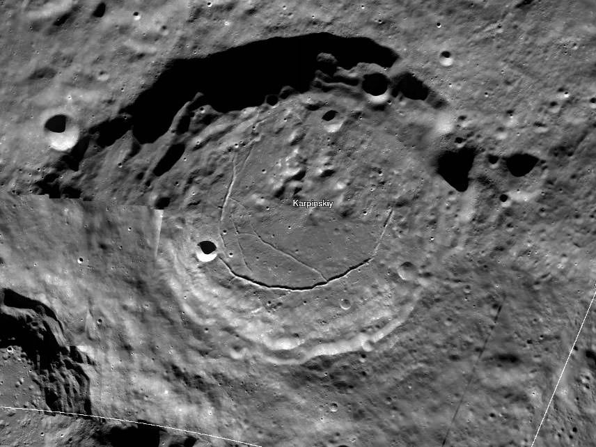
Wide view of the 91-km Karpinskiy Crater from the new interactive north pole mosaic. See image below for a zoomed-in view. Credit: NASA/GSFC/Arizona State Univ.
When you call up the map, be sure to click first on the full-screen button below the zoom slider. Now you’re ready for the full experience. With mouse in hand, you’re free to zoom and pan as you please. Take in the view of Whipple Crater shadowed in polar darkeness or zoom to the bottom of Karpinskiy Crater and fly like a bird over its fractured floor.
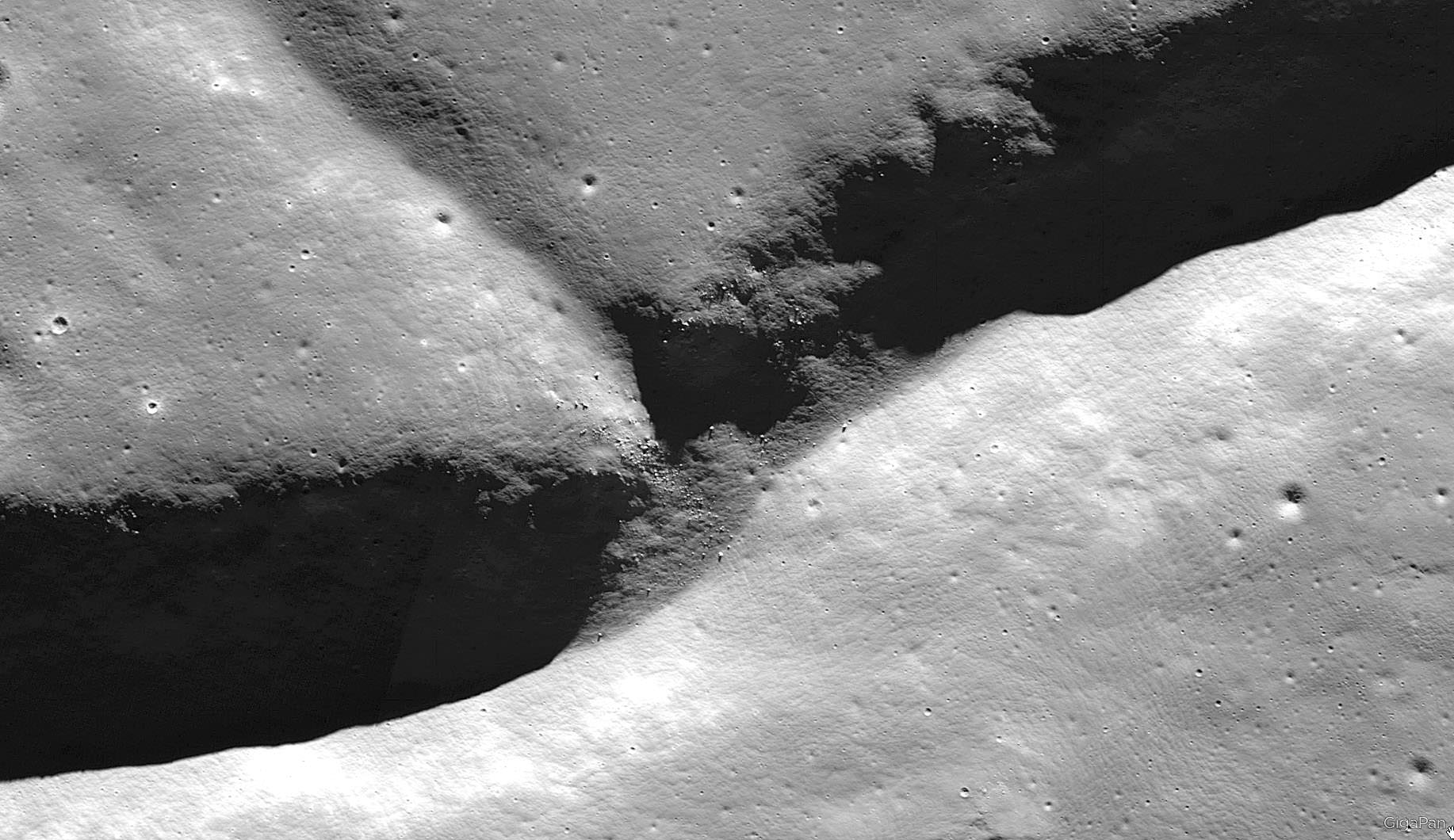
In this photo, we come in for a closer look at the fracture or rill in Karpinskiy’s floor. Notice the small, lighter-toned boulders on the cliff side. The images were all taken with the Lunar Reconnaissance Orbiter’s Narrow Angle Camera (NAC). Credit: NASA/GFSC/Arizona State Univ.
The images are so detailed and the zoom so smooth, there’s nothing artificial about the ride. Except the fact you’re not actually orbit. Darn close though. All the pictures were taken over the past few years by NASA’s Lunar Reconnaissance Orbiter which can fly as low as 50 km (31 miles) over the lunar surface and resolve details the size of a desk.
Printed at 300 dpi – a high-quality printing resolution that requires you to peer very closely to distinguish pixels – the mosaic map would be larger than a football field. Credit: NASA
There are 10 snapshots along the bottom of the map – click them and you’ll be swiftly carried directly to that feature. One of them is the lunar gravity probe GRAIL-B impact site.
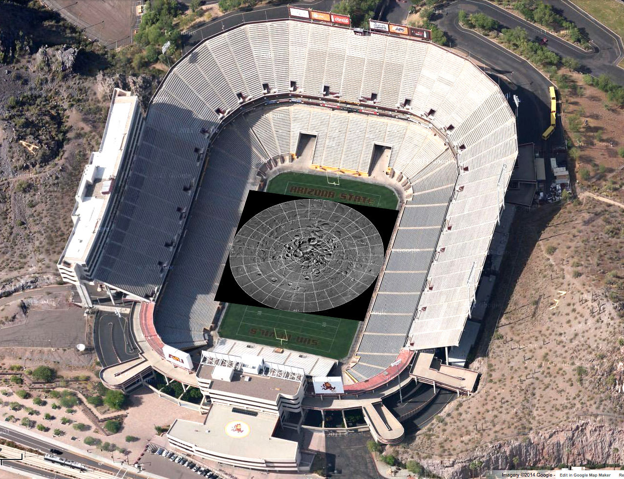
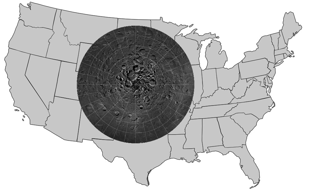
The region the gigapixel map covers superimposed on the outline of the U.S. Credit: NASA
To create the 2-D map, a polar stereographic projection was used in to limit mapping distortions. In addition, the LROC team used information from the LOLA and GRAIL teams and an improved camera pointing model to accurately project each image in the mosaic to within 20 meters. For more information on the project, click HERE.
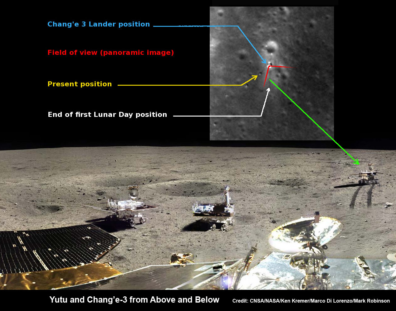
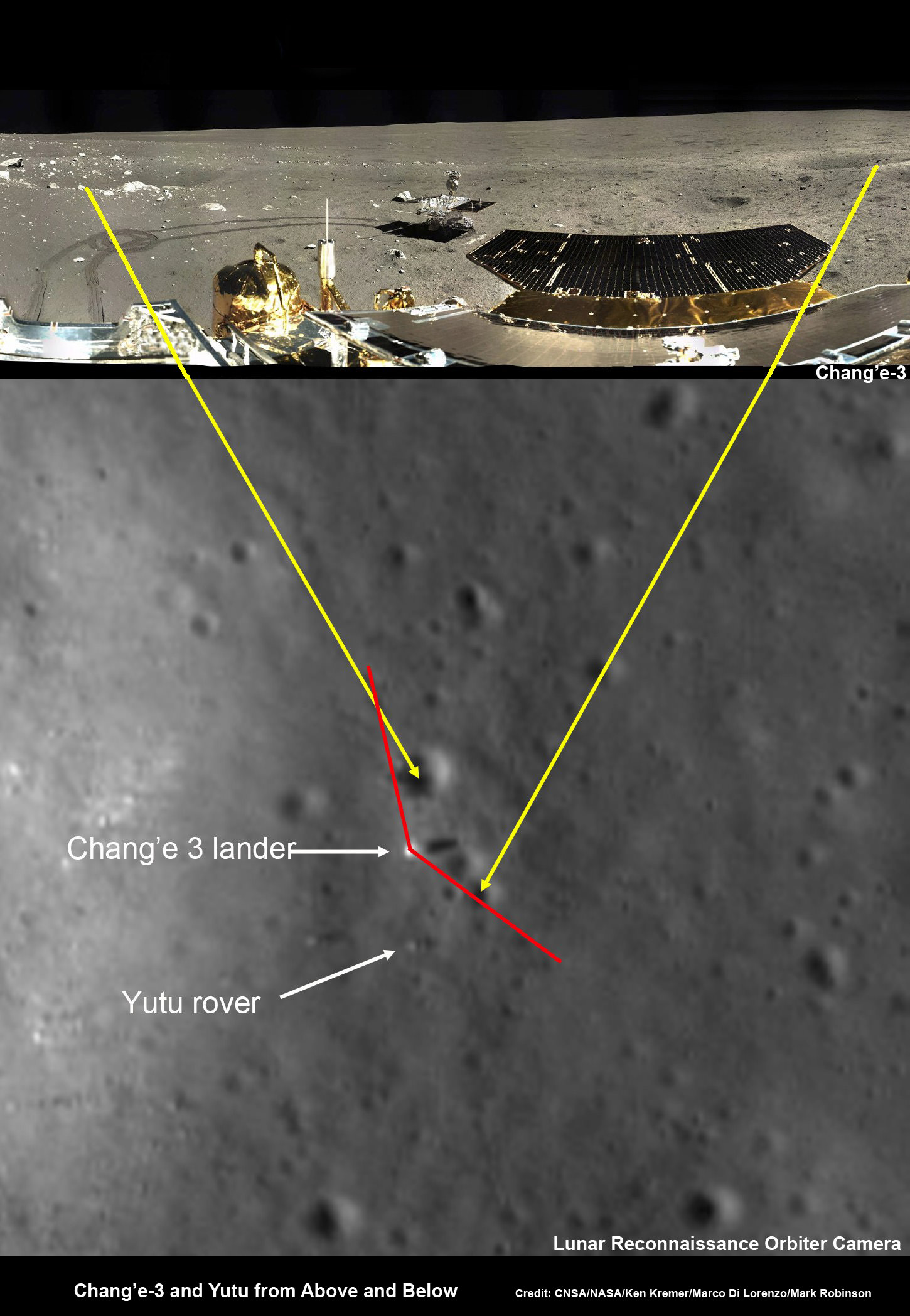
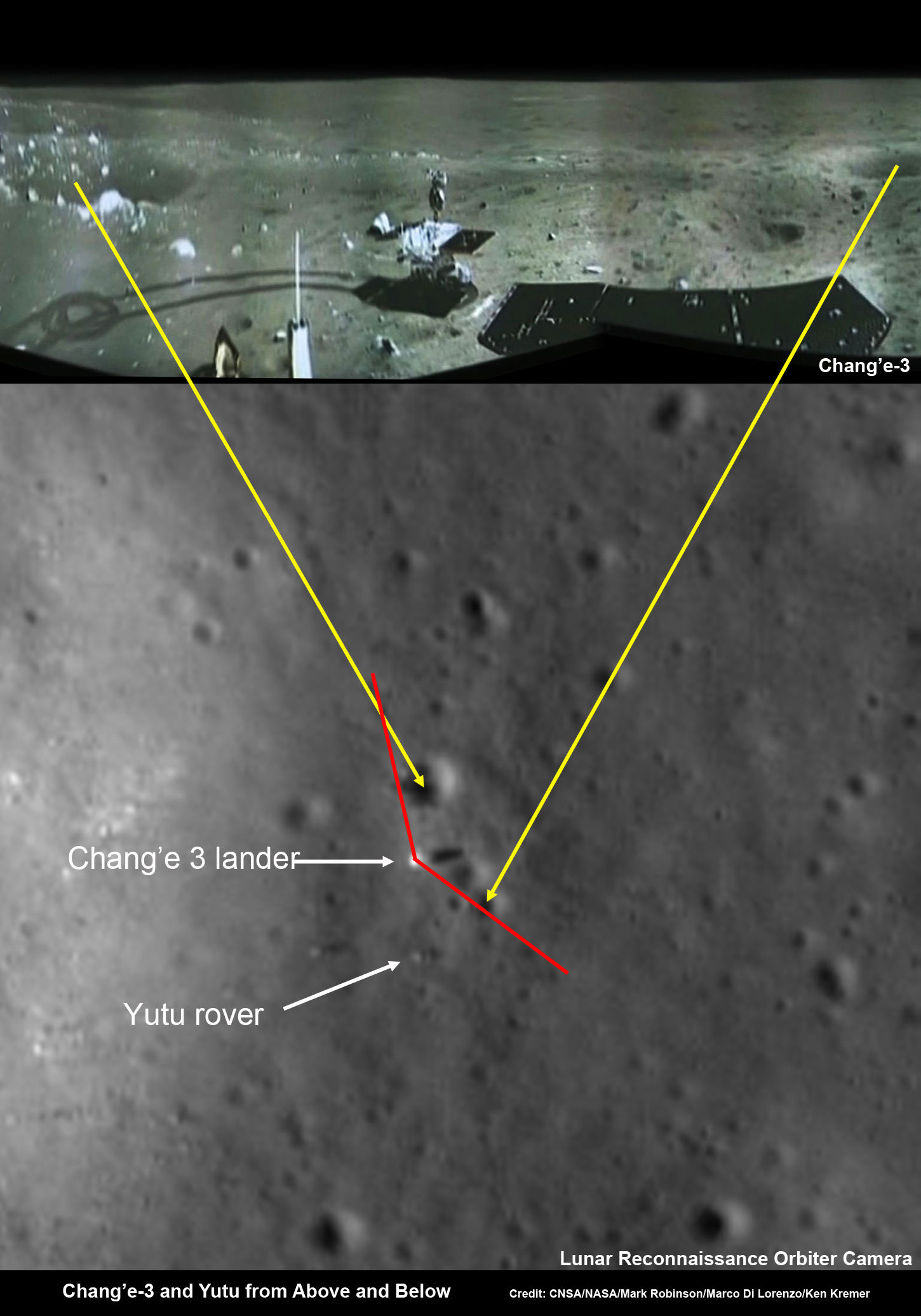
Yutu rover drives around Chang’e-3 lander – from Above And Below. Composite view shows China’s Yutu rover and tracks driving in clockwise direction around Chang’e-3 lander from Above And Below (orbit and surface). The Chang’e-3 timelapse lander color panorama (bottom) and orbital view (top) from NASA’s LRO orbiter shows Yutu rover after it drove down the ramp to the moon’s surface and began driving around the landers right side, passing by craters and heading south on Lunar Day 1. It then moved northwest during Lunar Day 2. Arrows show Yutu’s positions over time. Credit: CNSA/NASA/Ken Kremer/Marco Di Lorenzo/Mark Robinson
Yutu rover drives around Chang’e-3 lander – from Above And Below
Composite view shows China’s Yutu rover and tracks driving in clockwise direction around Chang’e-3 lander from Above And Below (orbit and surface). The Chang’e-3 timelapse lander color panorama (bottom) and orbital view (top) from NASA’s LRO orbiter shows Yutu rover after it drove down the ramp to the moon’s surface and began driving around the landers right side, passing by craters and heading south on Lunar Day 1. It then moved northwest during Lunar Day 2. Arrows show Yutu’s positions over time.
Credit: CNSA/NASA/Ken Kremer/Marco Di Lorenzo/Mark Robinson
See below more mosaics and LRO imagery
Story updated[/caption]
The powerful telescopic camera aboard NASA’s Lunar Reconnaissance Orbiter (LRO) has captured spectacular new images detailing the traverse of China’s Yutu moon rover around the landing site during its first two months exploring the Moon’s pockmarked grey terrain.
The newly released high resolution LRO images even show Yutu’s tracks cutting into the lunar surface as the world famous Chinese robot drove in a clockwise direction around the Chang’e-3 lander that delivered it to the ground in mid-December 2013.
You can precisely follow Yutu’s movements over time – from ‘above and below’ – in our new composite view (shown above) combining the latest LRO image with our timelapse mosaic showing the rover’s history making path from the touchdown point last December to today’s location.
Yutu is China’s first ever Moon rover and successfully accomplished a soft landing on the Moon on Dec. 14, 2013, piggybacked atop the Chang’e-3 mothership lander.
Barely seven hours after touchdown, the six wheeled moon buggy drove down a pair of ramps onto the desolate gray plains of the lunar surface at Mare Imbrium (Sea of Rains) covered by volcanic material.
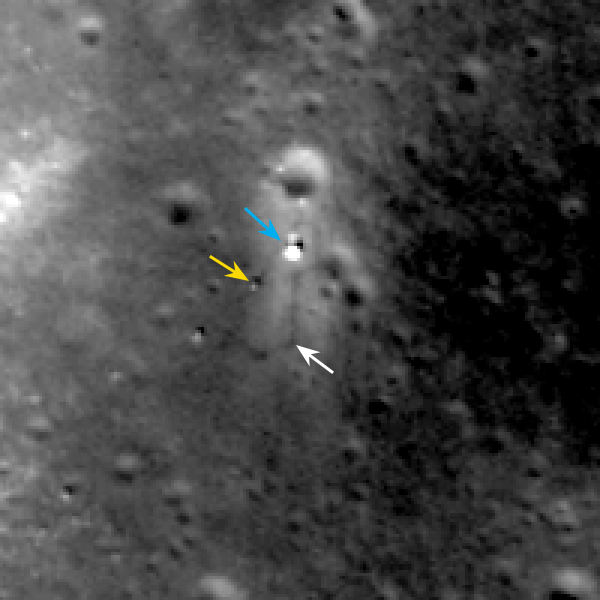
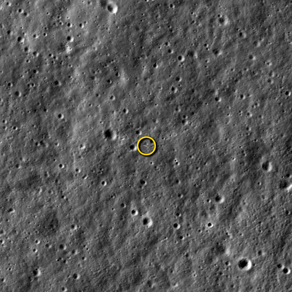
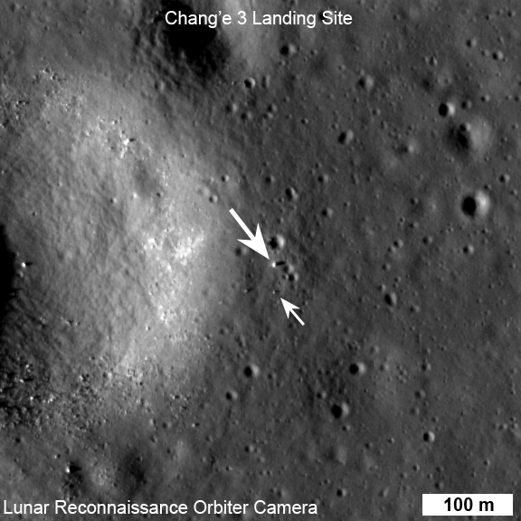
LROC February 2014 image of Chang’e 3 site. Blue arrow indicates Chang’e 3 lander; yellow arrow points to Yutu (rover); and white arrow marks the December location of Yutu. Yutu’s tracks can be followed clockwise around the lander to its current location. Image width 200 meters (about 656 feet). Credit: NASA/Goddard/Arizona State University
Altogether three images of the rover and lander have been taken to date by the Lunar Reconnaissance Orbiter Camera (LROC) aboard LRO – specifically the hi res narrow angle camera (NAC).
The LROC NAC images were captured on Dec. 25, 2013, Jan. 21, 2014 and Feb. 17, 2014 as LRO soared overhead.
The four image LRO composite below includes a pre-landing image taken on June 30, 2013.
Four LROC NAC views of the Chang’e 3 landing site. A) before landing, June 30, 2013 B) after landing, Dec. 25, 2013 C) Jan. 21, 2014 D) Feb. 17, 2014 Width of each image is 200 meters (about 656 feet). Follow Yutu’s path clockwise around the lander in “D.” Credit: NASA/Goddard/Arizona State University
Since the solar incidence angles were different, the local topography and reflectance changes between images showing different levels of details.
“In the case of the Chang’e 3 site, with the sun higher in the sky one can now see the rover Yutu’s tracks (in the February image),” wrote Mark Robinson, Principal Investigator for the LROC camera in an LRO update.
The solar powered rover and lander can only operate during periods of lunar daylight, which last 14 days each.
During each lunar night, they both must power down and enter hibernate mode since there is no sunlight available to generate power and no communications are possible with Earth.
Here is a gif animation from the NASA LRO team combining all four LROC images.
Four views of the Chang’e 3 landing site from before the landing until Feb. 2014. Credit: NASA/GSFC/Arizona State University
During Lunar Day 1, Yutu drove down the landers ramps and moved around the right side in a clockwise direction.
By the end of the first lunar day, Yutu had driven to a position about 30 meters (100 feet) south of the Chang’e-3 lander, based on the imagery.
See our complete 360 degree timelapse color panorama from Lunar Day 1 herein and at NASA APOD on Feb. 3, 2014 – assembled by Marco Di Lorenzo and Ken Kremer.
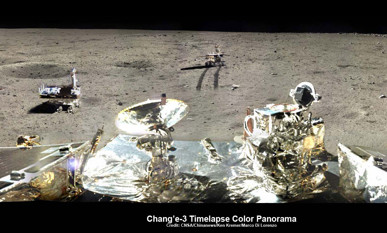
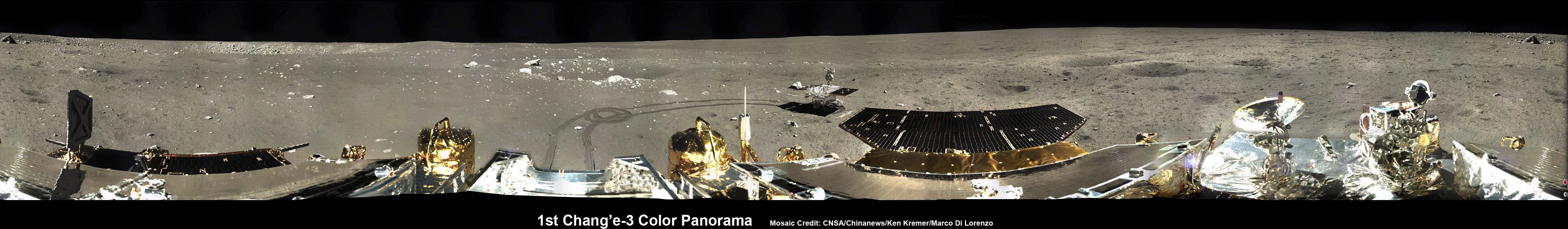
360-degree time-lapse color panorama from China’s Chang’e-3 lander. This new 360-degree time-lapse color panorama from China’s Chang’e-3 lander shows the Yutu rover at five different positions, including passing by crater and heading south and away from the Chang’e-3 lunar landing site forever during its trek over the Moon’s surface at its landing site from Dec. 15-22, 2013 during the 1st Lunar Day. Credit: CNSA/Chinanews/Ken Kremer/Marco Di Lorenzo – kenkremer.com. See our Yutu timelapse pano at NASA APOD Feb. 3, 2014: http://apod.nasa.gov/apod/ap140203.htm
After awakening for Lunar Day 2, Yutu then moved northwest and parked about 17 meters (56 feet) southwest of the lander, according to Robinson.
By comparing the Janaury and February images “it is apparent that Yutu did not move appreciably from the January location,” said Robinson.
At this moment Yutu and the companion Chang’e-3 lander are sleeping through their 3rd Lunar Night.
They entered hibernation mode on Feb. 22 and Feb. 23, 2014 respectively.
Hopefully both probes will awaken from their slumber sometime in the next week when the Moon again basks in daylight glow to begin a 4th day of lunar surface science operations.
“We all wish it would be able to wake up again,” said Ye Peijian, chief scientist of the Chang’e-3 program, according to CCTV, China’s state run broadcaster.
However, the hugely popular ‘Yutu’ rover is still suffering from an inability to maneuver its life giving solar panels. It is also unable to move – as I reported here.
The 140 kg rover is now nearing its planned 3 month long life expectancy on a moon roving expedition to investigate the moon’s surface composition and natural resources.
Chang’e-3/Yutu Timelapse Color Panorama
This newly expanded timelapse composite view shows China’s Yutu moon rover at two positions passing by crater and heading south and away from the Chang’e-3 lunar landing site forever about a week after the Dec. 14, 2013 touchdown at Mare Imbrium. This cropped view was taken from the 360-degree timelapse panorama. See complete 360 degree landing site timelapse panorama herein and APOD Feb. 3, 2014. Chang’e-3 landers extreme ultraviolet (EUV) camera is at right, antenna at left. Credit: CNSA/Chinanews/Ken Kremer/Marco Di Lorenzo – kenkremer.com. See our complete Yutu timelapse pano at NASA APOD Feb. 3, 2014: http://apod.nasa.gov/apod/ap140203.htm
China is only the 3rd country in the world to successfully soft land a spacecraft on Earth’s nearest neighbor after the United States and the Soviet Union.
Stay tuned here for Ken’s continuing Chang’e-3, Orion, Orbital Sciences, SpaceX, commercial space, LADEE, Mars and more planetary and human spaceflight news. Learn more at Ken’s upcoming presentations at the NEAF astro/space convention on April 12/13.
Chang’e-3 lander and Yutu rover – from Above And Below Composite view shows China’s Chang’e-3 lander and Yutu rover from Above And Below (orbit and surface) – lander color panorama (top) and orbital view from NASA’s LRO orbiter (bottom). Chang’e-3 lander color panorama shows Yutu rover after it drove down the ramp to the moon’s surface and began driving around the landers right side to the south. Yellow lines connect craters seen in the lander panorama and the LROC image from LRO (taken at a later date after the rover had moved), red lines indicate approximate field of view of the lander panorama. Credit: CNSA/NASA/Ken Kremer/Marco Di Lorenzo/Mark RobinsonLRO slewed 54 degrees to the east on Feb. 16, 2014, to allow the LROC instrument to snap a dramatic oblique view of the Chang’e 3 site (arrow). Crater in front of lander is 450 meters (about 1,476 feet) in diameter. Image width is 2,900 meters (about 9,500 feet) at the center. Credit: NASA/Goddard/Arizona State University
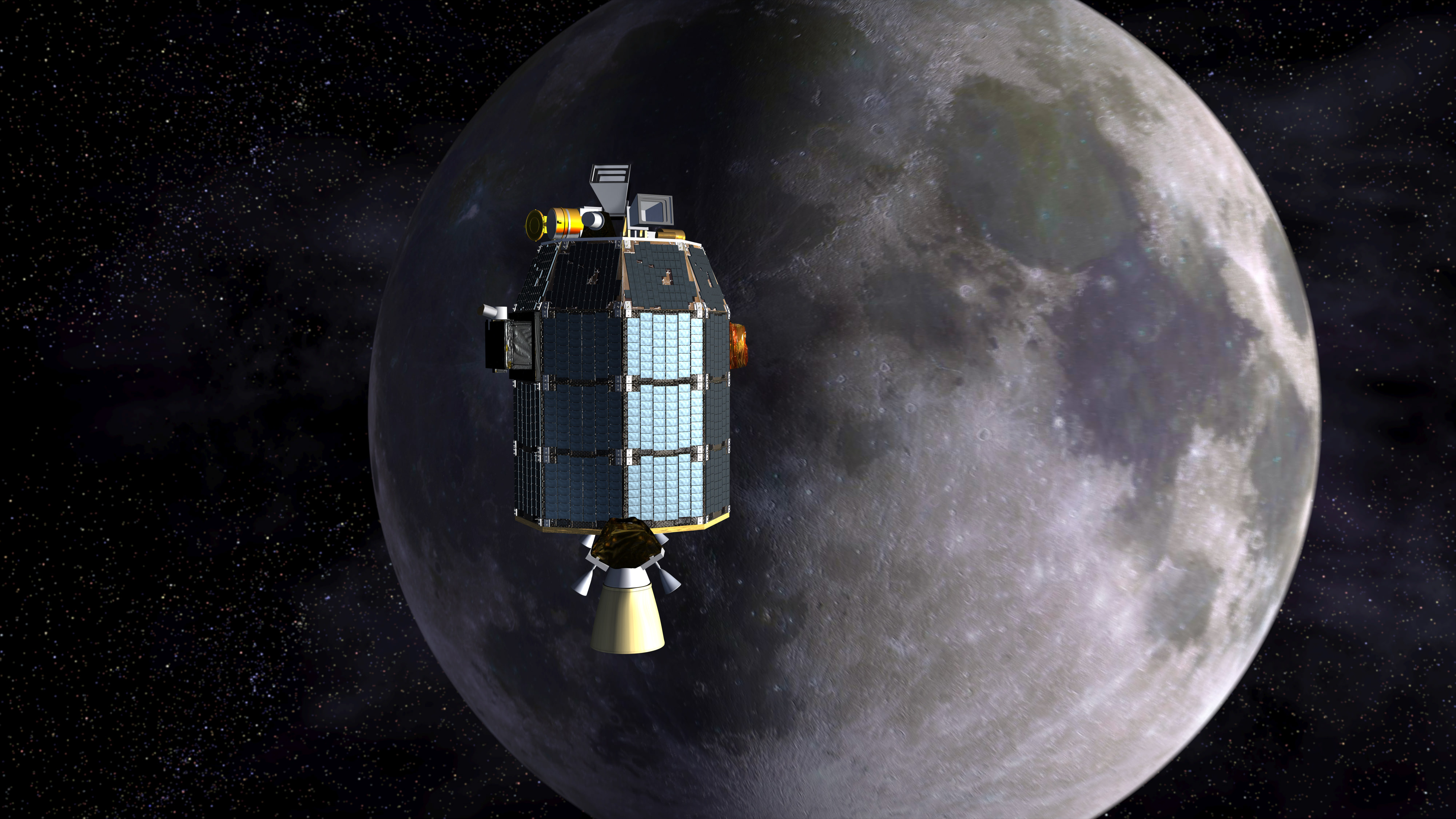
Depiction of NASA's Lunar Atmosphere and Dust Environment Explorer (LADEE) observatory as it approaches lunar orbit.Credit: NASA Ames/Dana Berry
Depiction of NASA’s Lunar Atmosphere and Dust Environment Explorer (LADEE) observatory as it approaches lunar orbit.Credit: NASA Ames/Dana Berry
LADEE will now orbit far lower than ever before – details below![/caption]
LADEE, NASA’s latest lunar orbiter, is getting a new lease on life and will live a little longer to study the mysteries of the body’s tenuous atmosphere, or exosphere, and make surprising new discoveries while hugging Earth’s nearest neighbor even tighter than ever before, the team told Universe Today.
NASA has announced that the Lunar Atmosphere and Dust Environment Explorer (LADEE) mission will be granted a month long extension since the residual rocket fuel is more than anticipated due to the expertise of LADEE’s navigation engineers.
This is great news because it means LADEE’s three research instruments will collect a big bonus of science measurements about the pristine lunar atmosphere and dust during an additional 28 days in an ultra tight low orbit skimming around the Moon.
And the extension news follows closely on the heels of LADEE being photographed in lunar orbit for the first time by a powerful camera aboard NASA’s five year old Lunar Reconnaissance Orbiter (LRO), her orbital NASA sister – detailed here.
This dissolve animation compares the LRO image (geometrically corrected) of LADEE captured on Jan 14, 2014 with a computer-generated and labeled image of LADEE . LRO and LADEE are both NASA science spacecraft currently in orbit around the Moon. Credit: NASA/Goddard/Arizona State University
LADEE is currently flying around the moon’s equator at altitudes ranging barely eight to 37 miles (12-60 kilometers) above the surface which crosses over from lunar day to lunar night approximately every two hours.
During the extended mission lasting an additional full lunar cycle, LADEE will fly even lower to within a few miles (km) thereby allowing scientists an exceptional vantage point to unravel the mysteries of the moon’s atmosphere.
Just how low will LADEE fly?
I asked Rick Elphic, LADEE project scientist at NASA Ames Research Center, Moffett Field, Calif.
“We will be taking LADEE from its nominal 20 to 50 kilometer periapsis right down to the treetops — we want to get data from 5 kilometers or even less!” Elphic told me.
“So far we’ve been keeping a healthy margin for spacecraft safety, but after the nominal mission is completed, we will relax those requirements in the interest of new science.”
With the measurements collected so far the science team has already established a baseline of data for the tenuous lunar atmosphere, or exosphere, and dust impacts, says NASA.
Therefore the LADEE team is free to fly the spacecraft much lower than ever before.
And why even go to lower altitudes? I asked Elphic.
Basically because the team hopes to see changes in the particle density and composition.
“The density depends on the species. For instance, argon-40 is heavier than neon-20, and has a lower scale height. That means we should see a big increase in argon compared to neon.”
“And we may see the heavier species for the first time at these really low altitudes.”
“It’s remotely possible we’ll see krypton, for instance.”
“But the real boon will be in the dust measurements.”
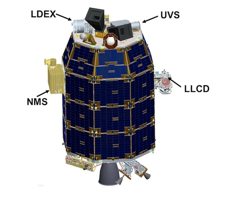
“LDEX (The Lunar Dust Experiment) will be measuring dust densities very close to the surface, and we will see if something new shows up. Each time we’ve dropped our orbit down to lower altitudes, we’ve been surprised by new things,” Elphic told Universe Today.
The Neutral Mass Spectrometer (NMS) instrument will measure the identity and abundances of the exospheres constituents, such as argon, neon and krypton.
LADEE Science Instrument locations
With the extension, LADEE is expected to continue capturing data in orbit until about April 21, 2014, depending on the usage of the declining on board fuel to feed its maneuvering thrusters.
“LADEE is investigating the moons tenuous exosphere, trace outgases like the sodium halo and lofted dust at the terminator,” Jim Green, Planetary Science Division Director at NASA HQ, told me earlier in an exclusive interview.
“The spacecraft has a mass spectrometer to identify the gases, a physical dust detector and an imager to look at scattered light from the dust. These processes also occur at asteroids.”
The Lunar Dust Experiment (LDEX) recorded dust impacts as soon as its cover opened, says NASA and is also seeing occasional bursts of dust impacts caused by meteoroid showers, such as the Geminids.
By studying the raised lunar dust, scientists also hope to solve a 40 year old mystery – Why did the Apollo astronauts and early unmanned landers see a glow of rays and streamers at the moon’s horizon stretching high into the lunar sky.
The science mission duration had initially been planned to last approximately 100 days and finish with a final impact on the Moon on about March 24th.
And the team had told me before launch that an extension was rather unlikely since the spacecraft would be flying in such a very low science orbit of about 50 kilometers altitude above the moon that it will require considerable fuel to maintain.
“LADEE is limited by the amount of onboard fuel required to maintain orbit,” Doug Voss, launch manager, Wallops, told me.
So what accounts for the extension?
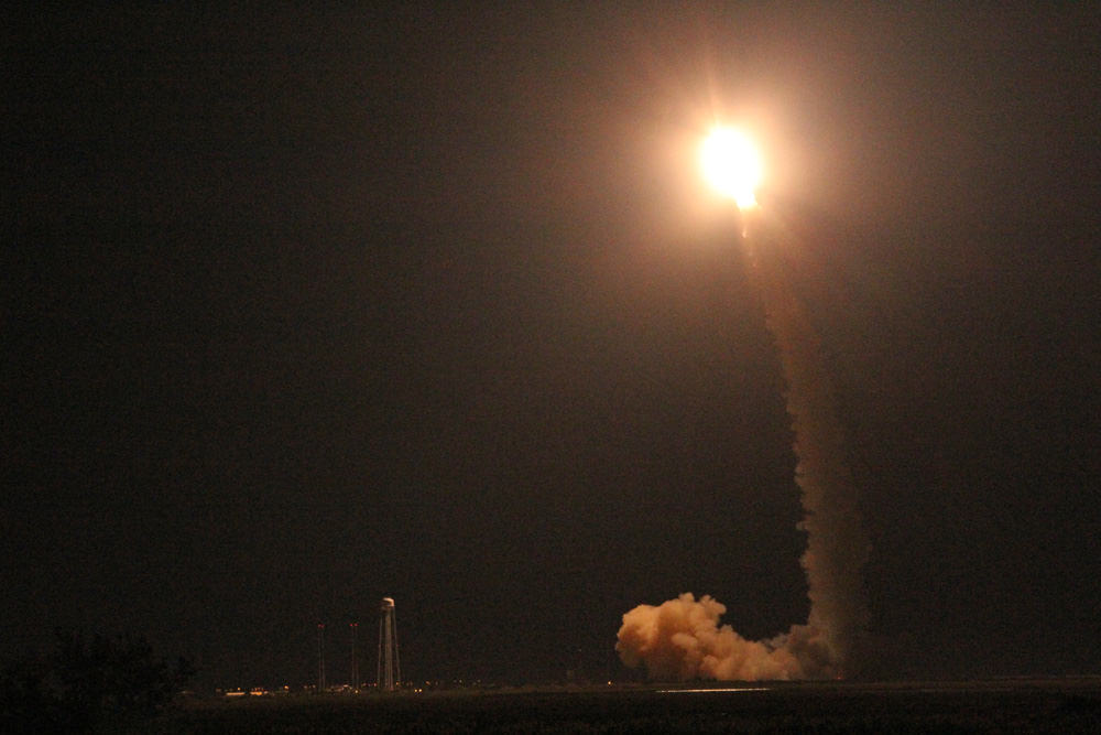
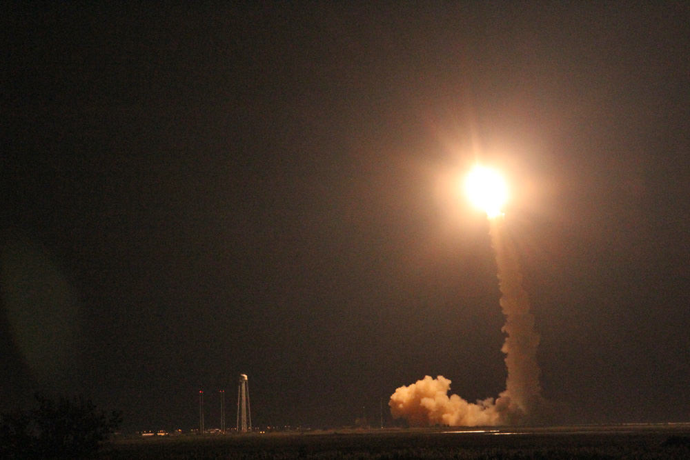
Basically it’s because of the expert navigation by NASA’s engineers and the Orbital Sciences Minotaur V rocket and upper stages following the spectacular night time LADEE blastoff from NASA Wallops, VA, on Sept. 6, 2013 and subsequent insertion into lunar orbit.
“The launch vehicle performance and orbit capture burns using LADEE’s onboard engines were extremely accurate, so the spacecraft had significant propellant remaining to enable extra science,” said Butler Hine, LADEE project manager at NASA’s Ames where the mission was designed, built, tested, in a NASA statement.
“This extension represents a tremendous increase in the amount of science data returned from the mission.”
Launch of NASA’s LADEE lunar orbiter on Friday night Sept. 6, at 11:27 p.m. EDT on the maiden flight of the Minotaur V rocket from NASA Wallops, Virginia, viewing site 2 miles away. Antares rocket launch pad at left. Credit: Ken Kremer/kenkremer.com
“LADEE launched with 134.5 kilograms of fuel. After the third lunar orbit insertion burn (LOI-3), 80% of our fuel had been consumed,” said Dawn McIntosh, LADEE deputy project manager at NASA Ames Research Center, in an exclusive interview with Universe Today.
“Additional orbit-lowering maneuvers with the orbital control system (OCS) and reaction control system (RCS) of approximately 40 seconds were used to get LADEE into the science orbit.
And LADEE’s orbit capture was accomplished amidst the ridiculous US government shutdown with a skeleton crew.
The spacecraft finally entered its planned two hour science orbit around the moon’s equator on Nov. 20.
So LADEE’s orbital lifetime depends entirely on the remaining quantity of rocket fuel.
“LADEE has about 20 kg of propellant remaining today,” Butler Hine told Universe Today.
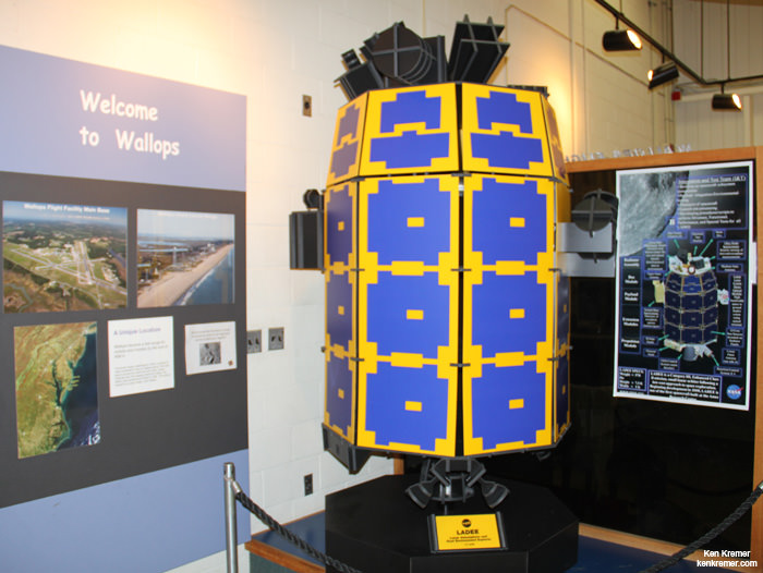
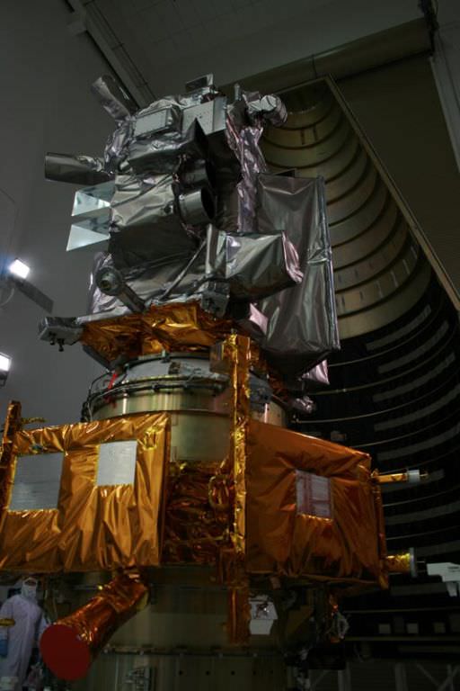
The 844 pound (383 kg) robot explorer is the size of a couch and was assembled at NASA’s Ames Research Center, Moffett Field, Calif., and is a cooperative project with NASA Goddard Spaceflight Center in Maryland.
Full scale model of NASA’s LADEE lunar orbiter on display at the free visitor center at NASA’s Wallops Flight Facility in Virginia. Credit: Ken Kremer/kenkremer.com
The $280 million probe is built on a revolutionary ‘modular common spacecraft bus’, or body, that could dramatically cut the cost of exploring space and also be utilized on space probes to explore a wide variety of inviting targets in the solar system.
“LADEE is the first in a new class of interplanetary exploration missions,” NASA Ames Center Director Pete Worden told me in an interview. “It will study the pristine moon to study significant questions.”
“This is probably our last best chance to study the pristine Moon before there is a lot of human activity there changing things.”
To date LADEE has traveled over 1 million miles and in excess of 1200 equatorial orbits around the Moon.
LADEE is also searching for any changes caused to the exosphere and dust by the landing of China’s maiden Chang’e-3 lander and Yutu moon rover in December 2013.
Stay tuned here for Ken’s continuing LADEE, Chang’e-3, Orion, Orbital Sciences, SpaceX, commercial space, Mars rover and more news.
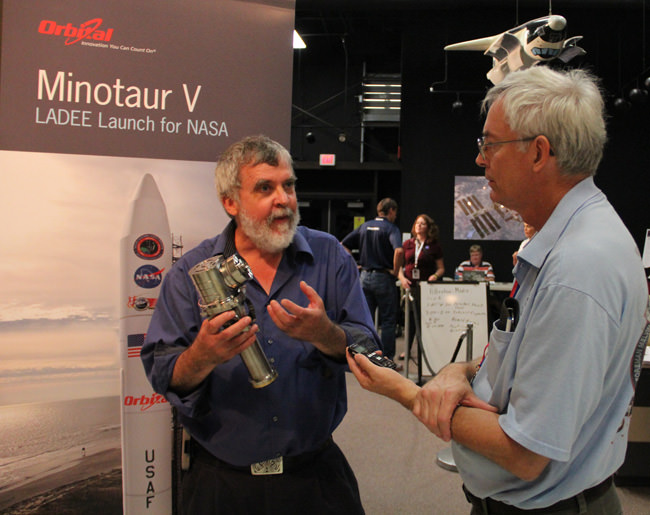
Paul Mahaffy, LADEE Neutral Mass Spectrometer instrument, principal investigator, and Ken Kremer/Universe Today discuss LADEE science at NASA Wallops Flight Facility, VA. Credit: Ken Kremer/kenkremer.com
This dissolve animation compares the LRO image (geometrically corrected) of LADEE captured on Jan 14, 2014 with a computer-generated and labeled image of LADEE . LRO and LADEE are both NASA science spacecraft currently in orbit around the Moon. Credit: NASA/Goddard/Arizona State University
This dissolve animation compares the LRO image (geometrically corrected) of LADEE captured on Jan 14, 2014 with a computer-generated and labeled image of LADEE . LRO and LADEE are both NASA science spacecraft currently in orbit around the Moon. Credit: NASA/Goddard/Arizona State University
Story updated[/caption]
A pair of NASA spacecraft orbiting Earth’s nearest celestial neighbor just experienced a brief ‘Close Encounter of the Lunar Kind’.
Proof of the rare orbital tryst has now been revealed by NASA in the form of spectacular imagery (see above and below) just released showing NASA’s recently arrived Lunar Atmosphere and Dust Environment Explorer (LADEE) lunar orbiter being photographed by a powerful camera aboard NASA’s five year old Lunar Reconnaissance Orbiter (LRO) – as the two orbiters met for a fleeting moment just two weeks ago.
See above a dissolve animation that compares the LRO image (geometrically corrected) of LADEE captured on Jan. 14, 2014 with a computer-generated and labeled LADEE image.
All this was only made possible by a lot of very precise orbital calculations and a spacecraft ballet of sorts that had to be nearly perfectly choreographed and timed – and spot on to accomplish.
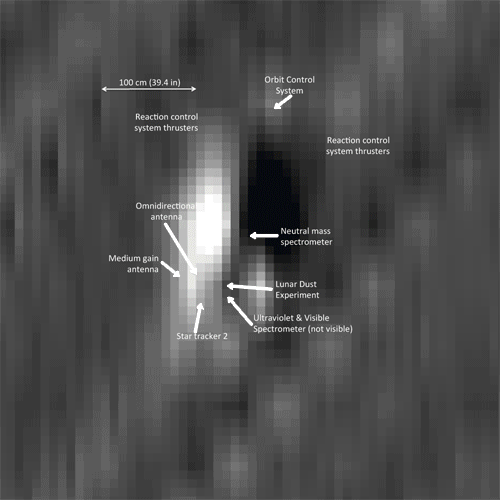
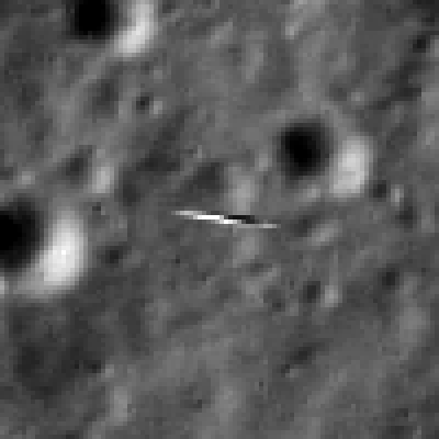
This subsection of the LRO image, expanded four times, shows the smeared view of LADEE against the lunar background. LADEE is about 2 meters in the long direction. Lunar scene about 81 meter wide. Credit: NASA/Goddard/Arizona State University
Both sister orbiters were speeding along at over 3600 MPH (1,600 meters per second) while traveling perpendicularly to one another!
So the glimpse was short but sweet.
LADEE flies in an equatorial orbit (east-to-west) while LRO travels in a polar orbit (south-to-north). LADEE achieved lunar orbit on Oct. 6, 2013 amidst the federal government shutdown.
Thus their orbits align only infrequently.
The LRO orbiter did a pirouette to precisely point its high resolution narrow angle camera (NAC) while hurtling along in lunar orbit, barely 5.6 miles (9 km) above LADEE.
And it was all over in less than the wink of an eye!
LADEE entered LRO’s Narrow Angle Camera (NAC) field of view for 1.35 milliseconds and a smeared image of LADEE was snapped. LADEE appears in four lines of the LROC image, and is distorted right-to-left.
Both spacecraft are tiny – barely two meters in length.
“Since LROC is a pushbroom imager, it builds up an image one line at a time, thus catching a target as small and fast as LADEE is tricky!” wrote Mark Robinson, LROC principal investigator of Arizona State University.
So the fabulous picture was only possible as a result of close collaboration and extraordinary teamwork between NASA’s LADEE, LRO and LROC camera mission operations teams.
NASA’s LRO imaged NASA’s LADEE, about 5.6 miles (9 km) beneath it, at 8:11 p.m. EST on Jan. 14, 2014. (LROC NAC image M1144387511LR). Image width is 821 meters, or about 898 yards.) Credit: NASA/Goddard/Arizona State University
LADEE passed directly beneath the LRO orbit plane a few seconds before LRO crossed the LADEE orbit plane, meaning a straight down LROC image would have just missed LADEE, said NASA.
LRO spacecraft (top) protected by gray colored blankets is equipped with 7 science instruments located at upper right side of spacecraft. LRO cameras are pointing to right. LRO is piggybacked atop NASA’s LCROSS spacecraft. Payload fairing in background protects the spacecraft during launch and ascent. Credit: Ken Kremer
Therefore, LRO was rolled 34 degrees to the west so the LROC detector (one line) would be precisely oriented to catch LADEE as it passed beneath.
“Despite the blur it is possible to find details of the spacecraft. You can see the engine nozzle, bright solar panel, and perhaps a star tracker camera (especially if you have a correctly oriented schematic diagram of LADEE for comparison),” wrote Robinson in a description.
See the LADEE schematic in the lead image herein.
LADEE was launched Sept. 6, 2013 from NASA Wallops in Virginia on a science mission to investigate the composition and properties of the Moon’s pristine and extremely tenuous atmosphere, or exosphere, and untangle the mysteries of its lofted lunar dust.
Since LADEE is now more than halfway through its roughly 100 day long mission, timing was of the essence before the craft takes a death dive into the moon’s surface.
You can see a full scale model of LADEE at the NASA Wallops visitor center, which offers free admission.
Full scale model of NASA’s LADEE lunar orbiter on display at the free visitor center at NASA’s Wallops Flight Facility in Virginia. Credit: Ken Kremer/kenkremer.com
LRO launched Sept. 18, 2009 from Cape Canaveral, Florida to conduct comprehensive investigations of the Moon with seven science instruments and search for potential landing sites for a return by human explorers. It has collected astounding views of the lunar surface, including the manned Apollo landing sites as well as a treasure trove of lunar data.
In addition to NASA’s pair of lunar orbiters, China recently soft landed two probes on the Moon.
So be sure to read my new story detailing how LRO took some stupendous Christmas time 2013 images of China’s maiden lunar lander and rover; Chang’e-3 and Yutu from high above- here.
Stay tuned here for Ken’s continuing LADEE, Chang’e-3, Orion, Orbital Sciences, SpaceX, commercial space, Mars rover and more news.
Launch of NASA’s LADEE lunar orbiter on Friday night Sept. 6, at 11:27 p.m. EDT on the maiden flight of the Minotaur V rocket from NASA Wallops, Virginia, viewing site 2 miles away. Antares rocket launch pad at left. Credit: Ken Kremer/kenkremer.com
Chang’e-3 lander and Yutu rover – from Above And Below Composite view shows China’s Chang’e-3 lander and Yutu rover from Above And Below (orbit and surface) – lander color panorama (top) and orbital view from NASA’s LRO orbiter (bottom). Chang’e-3 lander color panorama shows Yutu rover after it drove down the ramp to the moon’s surface and began driving around the landers right side to the south. Yellow lines connect craters seen in the lander panorama and the LROC image from LRO (taken at a later date after the rover had moved), red lines indicate approximate field of view of the lander panorama. Credit: CNSA/NASA/Ken Kremer/Marco Di Lorenzo/Mark Robinson
Chang’e-3 lander and Yutu rover – from Above And Below
Composite view shows China’s Chang’e-3 lander and Yutu rover from Above And Below (orbit and surface) – lander color panorama (top) and orbital view from NASA’s LRO orbiter (bottom). Chang’e-3 lander color panorama shows Yutu rover after it drove down the ramp to the moon’s surface and began driving around the landers right side to the south. Yellow lines connect craters seen in the lander panorama and the LROC image from LRO (taken at a later date after the rover had moved), red lines indicate approximate field of view of the lander panorama. Credit: CNSA/NASA/Ken Kremer/Marco Di Lorenzo/Mark Robinson
See further composite and panorama views below
Story updated See our Yutu timelapse pano at NASA APOD Feb. 3, 2014: http://apod.nasa.gov/apod/ap140203.html[/caption]
China’sChang’e-3 lander and Yutu moon rover have been imaged from above and below – in one of those rare, astounding circumstances when space probes from Earth are exploring an extraterrestrial body both from orbit and the surface. And it’s even more amazing when these otherworldly endeavors just happen to overlap and involve actual work in progress to expand human knowledge of the unknown.
And it’s even rarer, when those images stem from active space probes built by two different countries on Earth.
Well by combining imagery from America’s space agency, NASA, and China’s space agency, CNSA, we are pleased to present some breathtaking views of ‘Chang’e-3 and the Yutu rover from Above and Below.’
Check out our composite mosaic (above) combining the view from the Moon’s orbit snapped by the hi res camera aboard NASA’s Lunar Reconnaissance Orbiter (LRO) with our new color panoramas from the Moon’s surface, compiling imagery from the landing site of China’s Chang’e-3 lander – with Yutu in transit in mid-Dec. 2013 soon after the successful touchdown.
See below an earlier composite mosaic using the first black and white panorama from the Chang’e-3 Moon lander.
Chang’e-3 lander and Yutu rover – from Above And Below
Composite view shows China’s Chang’e-3 lander and Yutu rover from Above And Below (orbit and surface) – lander panorama (top) and orbital view from NASA’s LRO orbiter (bottom). Chang’e-3 lander B/W panorama from camera shows Yutu rover after it drove down the ramp to the moon’s surface and began driving around the landers right side to the south. Yellow lines connect craters seen in the lander panorama and the LROC image from LRO (taken at a later date after the rover had moved), red lines indicate approximate field of view of the lander panorama. Credit: CNSA/NASA/Mark Robinson/Marco Di Lorenzo/Ken Kremer – kenkremer.com
The composite mosaic combines the efforts of Mark Robinson, Principal Investigator for the LRO camera, and the imaging team of Ken Kremer and Marco Di Lorenzo.
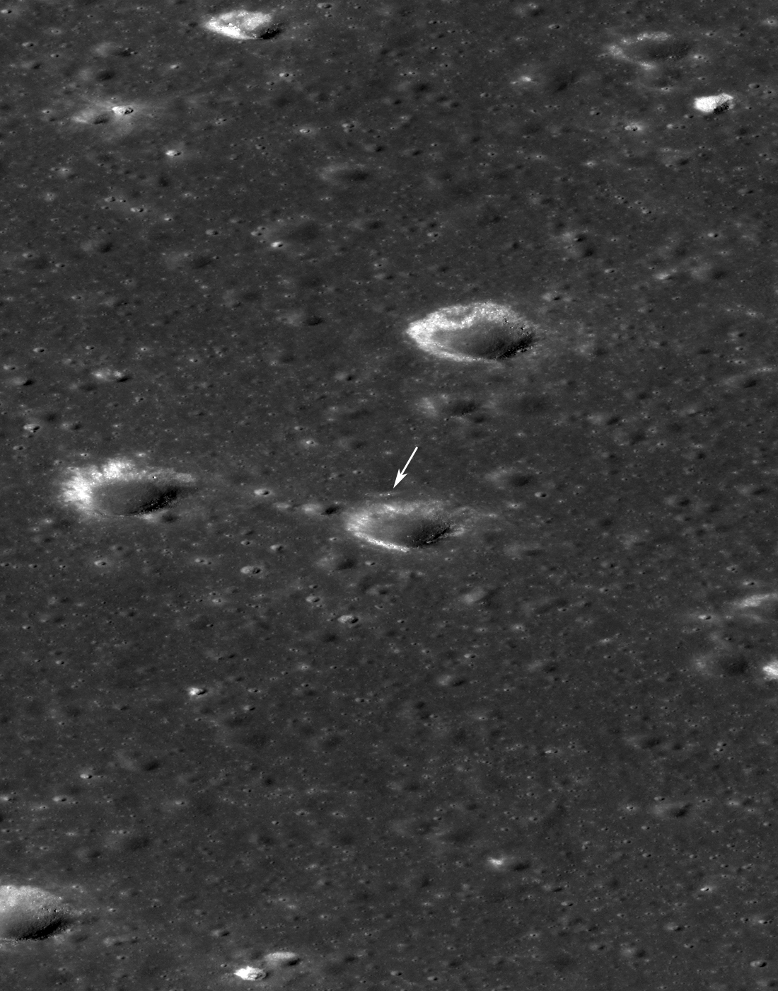
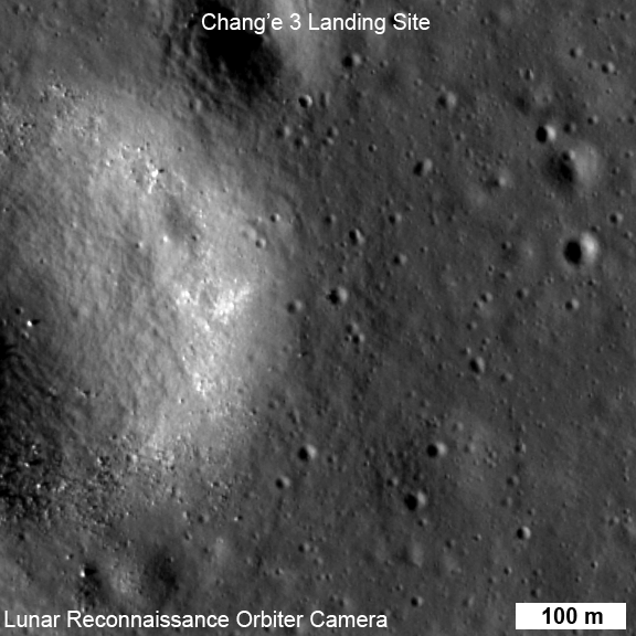
On Christmas eve, Dec. 24, 2013, NASA’s LRO captured it’s first images of China’s Chang’e-3 lander and Yutu moon rover – barely 10 days after the history making touchdown on Mare Imbrium (Sea of Rains) and just 60 meters east of the rim of a 450 meter diameter impact crater.
LRO was orbiting about 150 kilometers above Chang’e-3 and Yutu when the highest resolution orbital image was taken on 24 December 22:52:49 EST (25 December 03:52:49 UT).
Image of Chang’e-3 (top arrow) and Yutu rover captured by NASA’s Lunar Reconnaissance Orbiter on Dec. 24, 2013
The orbital imagery was taken by the LRO orbiters high resolution Lunar Reconnaissance Orbiter Camera (LROC) – specifically the narrow angle camera (NAC).
See below my pre-launch cleanroom photo of LRO and the LROC cameras and other science instruments.
The Chang’e-3 lander color panorama shows the Yutu rover after it drove down the ramp to the moon’s surface and began driving a significant distance around the landers right side on its journey heading southwards.
1st 360 Degree Color Panorama from China’s Chang’e-3 Lunar Lander
This 1st color panorama from Chang’e-3 lander shows the view all around the landing site after the ‘Yutu’ lunar rover left impressive tracks behind when it initially rolled all six wheels onto the pockmarked and gray lunar terrain on Dec. 15, 2013. Mosaic Credit: CNSA/Chinanews/Ken Kremer/Marco Di Lorenzo – kenkremer.com
Yellow lines connect craters seen in the lander panorama to those seen in the LROC hi res NAC image from LRO, in the composite view.
Robinson identified the lunar craters and determined the field of view on the LROC image.
The LRO image was taken at a later date (on Christmas eve) after the rover had already moved. Red lines on the orbital image indicate the approximate field of view of what is seen in the Chang’e-3 lander panorama.
Although Yutu is only about 150 cm wide – which is the same as the pixel size – it shows up in the NAC images for two reasons.
“The solar panels are very effective at reflecting light so the rover shows up as two bright pixels, and the Sun is setting thus the rover casts a distinct shadow (as does the lander),” says NASA in a statement.
In a historic first for China, the Chang’e-3 spacecraft safely touched down on the Moon at Mare Imbrium near the Bay of Rainbows nearly seven weeks ago on Dec. 14, 2013.
Seven hours later, the piggybacked 140 kg Yutu robot drove off a pair of ramps, onto the Moon and into the history books.
Yutu was about 10 meters away from the 1200 kg stationary lander when the lander panoramic images were taken.
The lander and Yutu were just completing their 1st Lunar Day of explorations when the LROC images were taken, and entered their first period of hibernation soon thereafter on Dec. 25 (Christmas Day) and Dec 26 respectively coinciding with the start of their 1st Lunar Night.
However, Yutu’s future mission is now in jeopardy following a serious mechanical anomaly this past weekend as both vehicles entered their 2nd hibernation period.
Apparently one of the solar panels did not fold back properly – perhaps due to dust accumulation – and its instruments may not survive.
Yutu’s fate will remain unknown until the 3rd Lunar Day starts around Feb. 8 or 9.
So, What’s the terrain like at the Mare Imbrium landing site?
Chang’e-3 landed on a thick deposit of volcanic material.
“A large scale wrinkle ridge (~100 km long, 10 km wide) cuts across the area and was formed as tectonic stress caused the volcanic layers to buckle and break along faults. Wrinkle ridges are common on the Moon, Mercury and Mars,” says Robinson.
“The landing site is on a blue mare (higher titanium) thought to be about 3.0 billion years old.”
Older red mare about from 3.5 billion years is only 10 km to the north, he notes.
See our Chang’e-3 color panoramas now featured at NBC News and Space.com
China is only the 3rd country in the world to successfully soft land a spacecraft on Earth’s nearest neighbor after the United States and the Soviet Union.
Stay tuned here for Ken’s continuing Chang’e-3, Orion, Orbital Sciences, SpaceX, commercial space, LADEE, Mars and more news.
NASA’s Lunar Reconnaissance Orbiter (LRO) LROC Wide angle camera (WAC) color (689 nm, 415 nm, 321 nm) overlain on WAC sunset BW image. Note the proximity of the landing site to a contact between red and blue maria. Credit: NASA/GSFC/Arizona State UniversityNASA’s LRO spacecraft (top) protected by gray colored blankets is equipped with 7 science instruments located at upper right side of spacecraft. LRO is piggybacked atop NASA’s LCROSS spacecraft. Payload fairing in background protects the spacecraft during launch and ascent on Atlas V rocket. Credit: Ken Kremer
Image of Chang'e-3 (top arrow) and Yutu rover captured by NASA's Lunar Reconnaissance Orbiter on Dec. 25 UTC
Not much on the Moon escapes the eyes of NASA’s Lunar Reconnaissance Orbiter, and China’s Chang’e-3 lander and Yutu rover are no exception! The pair touched down on the lunar surface on Dec. 14, and just over a week later on Dec. 25 LRO acquired the image above, showing the lander and the 120-kg (265-lb) “Jade Rabbit” rover at their location near the Moon’s Sinus Iridum region.
The width of the narrow-angle camera image is 576 meters; north is up. LRO was about 150 km (93 miles) from the Chang’e-3 site when the image was acquired.
So how can we be so sure that those bright little specks are actually human-made robots and not just a couple of basaltic boulders? Find out below:
The rover is only about 150 cm wide, yet it shows up in the NAC images for two reasons: the solar panels are very effective at reflecting light so the rover shows up as two bright pixels, and the Sun is setting thus the rover casts a distinct shadow (as does the lander). Since the rover is close to the size of a pixel, how can we be sure we are seeing the rover and not a comparably sized boulder? Fortuitously, the NAC acquired a “before” image of the landing site, with nearly identical lighting, on 30 June 2013. By comparing the before and after landing site images, the LROC team confirmed the position of the lander and rover, and derived accurate map coordinates for the lander (44.1214°N, 340.4884°E, -2640 meters elevation).
Before-and-after LROC images of Chang’e-3’s landing site: June 30 vs. Dec. 25, 2013
LRO circles the Moon in a polar orbit at an average altitude of 50 km (31 miles). The LROC instrument contains two narrow-angle camera heads (NACs) providing 0.5-meter/pixel panchromatic images over a 5-km swath, a wide-angle camera head (WAC) providing images at a scale of 100 meters in seven-color bands.
Both the Chang’e-3 lander and Yutu rover are reported to be in good health and performing well. The solar-powered rover went into sleep mode on Dec. 26 to wait out the 14-day lunar night, during which time the temperatures on the lunar surface can drop to -180ºC (-292ºF). Yutu’s radioisotope heat source will keep it from freezing, but it won’t be able to generate power from its solar arrays. (Source)
Read more on ASU’s LROC website, and check out Ken Kremer’s article featuring a video of Yutu’s rollout here.
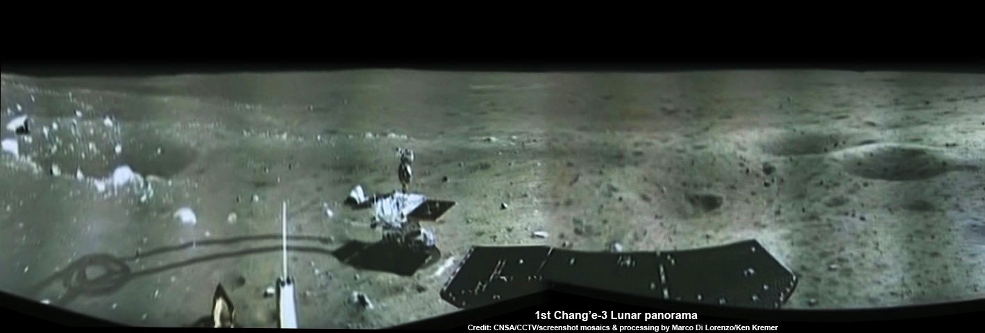
Portion of 1st panorama around Chang’e-3 landing site showing China’s Yutu rover leaving tracks in the lunar soil as it drives across the Moon’s surface on Dec. 15, 2013. Images taken by Chang’e-3 lander following Dec. 14 touchdown. Panoramic view was created from screen shots of a news video assembled into a mosaic. Credit: CNSA/CCTV/screenshot mosaics & processing by Marco Di Lorenzo/Ken Kremer
1st Chang’e-3 Lunar Panorama
Portion of 1st panorama around Chang’e-3 landing site showing China’s Yutu rover leaving tracks in the lunar soil as it drives across the Moon’s surface on Dec. 15, 2013. Images taken by Chang’e-3 lander following Dec. 14 touchdown. Panoramic view was created from screen shots of a news video assembled into a mosaic.
Credit: CNSA/CCTV/screenshot mosaics & processing by Marco Di Lorenzo/Ken Kremer
See below robotic arm screenshots – – Story updated [/caption]
As night fell on the Earth’s Moon, China’s Yutu rover and mothership lander have both entered a state of hibernation determined to survive the frigidly harsh lunar night upon the magnificently desolate gray plains.
Yutu went to sleep at 5:23 a.m. Dec. 26, Beijing time, upon a command sent by mission control at the Beijing Aerospace Control Center (BACC), according to China’s State Administration of Science, Technology and Industry for National Defence (SASTIND).
The Chang’e-3 lander began its long nap hours earlier at 11:00 a.m. Beijing time on Christmas Day, Dec. 25.
The vehicles must now endure the lunar night, which spans 14 Earth days in length, as well as the utterly low temperatures which plunge to below minus 180 degrees Celsius.
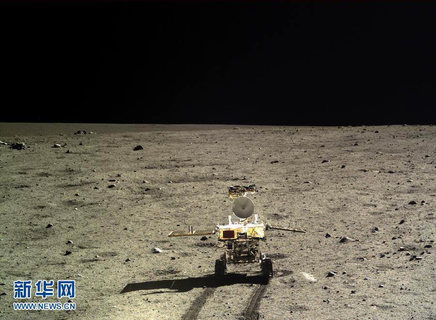
Yutu rover points mast with cameras and high gain antenna downwards to inspect lunar soil around landing site in this photo taken by Chang’e-3 lander. Credit: CNSA
Scientists completed a series of engineering tests on the probes to ensure they were ready to withstand the steep temperature drop, said Wu Fenglei of the Beijing Aerospace Control Center, to the Xinhua state news agency.
Since there is no sunlight, the solar panels can’t provide any power and have been folded back.
So they face a massive engineering challenge to endure the extremely cold lunar night.
Therefore in order to survive the frigid lunar environment, a radioisotopic heat source is onboard to provide heat to safeguard the rovers and landers delicate computer and electronics subsystems via the thermal control system.
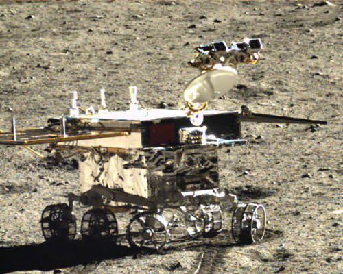
They are situated inside a warmed box below the deck that must be maintained at a minimum temperature of about minus 40 degrees Celsius to prevent debilitating damage. Yutu prepares to flex robotic arm in this screen shot from a CCTV video animation. Credit: CNSA/CCTV/screenshot by R. Mackelenbergh/K. Kremer/M. Di Lorenzo
So the two spacecraft still have to prove they can hibernate and eventually emerge intact from the unforgiving lunar night.
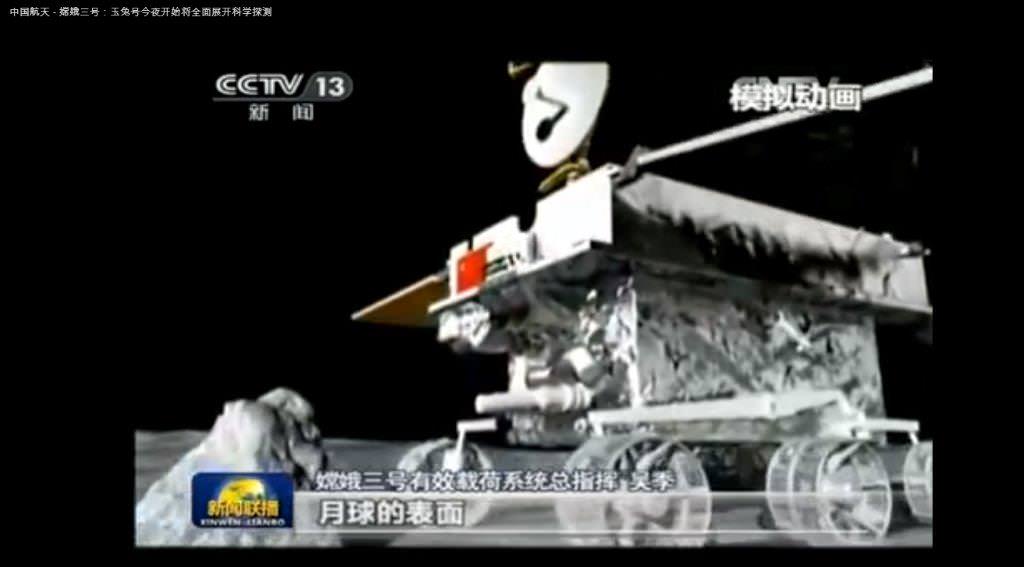
Just prior to going to sleep, the 140 kg Yutu rover flexed its robotic arm and Chinese space engineers at BACC completed an initial assessment testing its joints and control mechanisms.
The short robotic arm appears similar in form and function to the one on NASA’s famous Spirit and OpportunityMars rovers.
It is equipped with an alpha particle X-ray instrument (APXS) – on the terminus – to determine the composition of lunar rocks and soil.
Yutu flexes robotic arm with APXS spectrometer towards rock in this screen shot from a CCTV video animation. Credit: CNSA/CCTV/screenshot by R. Mackelenbergh/K. Kremer/M. Di Lorenzo
The robotic pair of spacecraft safely soft landed on the Moon on Dec. 14 at Mare Imbrium, nearby the Bay of Rainbows, or Sinus Iridum region. It is located in the upper left portion of the moon as seen from Earth. You can easily see the landing site with your own eyes.
Barely seven hours after the history making touchdown, ‘Yutu’ was painstakingly lowered from its perch atop the lander and then successfully drove all six wheels onto the moon’s surface on Dec. 15.
Yutu left noticeable tracks behind, several centimeters deep, as the wheels cut into the loose lunar regolith.
The Chang’e-3 lander and rover then conducted an initial survey of the stark lunar landing site, pockmarked with craters and small boulders.
They took an initial pair of portraits of one another. Read my earlier report – here.
The four legged lunar lander also snapped the missions first panoramic view of the touchdown spot at Mare Imbrium using three panoramic cameras (Pancams) pointing in different directions. Read my earlier report – here.
See the eerie panoramic view of the landing site showing Yutu’s first moments on the alien lunar surface in our screenshot mosaic above – and here.
See the dramatic video with an astronauts eye view of the lunar descent and touchdown in my prior story – here.
Yutu, which translates as ‘Jade Rabbit’, was then directed to travel in a semicircular path around the right side of the lander and is heading to the south.
Its currently napping about 40 meters to the south.
China’s 1st Moon rover ‘Yutu’ embarks on thrilling adventure marking humanity’s first lunar surface visit in nearly four decades. Yutu portrait taken by the Chang’e-3 lander. Credit: CNSA/CCTV
‘Jade Rabbit’ will resume the lunar trek upon awakening, along with the stationary lander, from their extended two week slumber around Jan 12, 2014.
Yutu will depart the Chang’e-3 landing zone forever and rove the moon’s surface for investigations expected to last at least 3 months – and perhaps longer depending on its robustness in the unforgiving space environment.
The robotic rover will use its suite of four science instruments to survey the moon’s geological structure and composition to locate the moon’s natural resources for use by potential future Chinese astronauts, perhaps a decade from now.
NASA’s Lunar Reconnaissance Orbiter (LRO) imaged the Chang’e-3 landing site in western Mare Imbrium around Christmas time on 24 and 25 December with its high resolution LROC camera and we’ll feature them here when available.
China is only the 3rd country in the world to successfully soft land a spacecraft on Earth’s nearest neighbor after the United States and the Soviet Union.
The best is surely yet to come!
Stay tuned here for Ken’s continuing Chang’e-3, LADEE, MAVEN, MOM, Mars rover and more news.