NASA/JAXA Precipitation Measurement Satellite ‘GO’ for Feb. 27 Launch – Watch Live Here on NASA TV

Visualization of the GPM Core Observatory and Partner Satellites. Credit: NASA

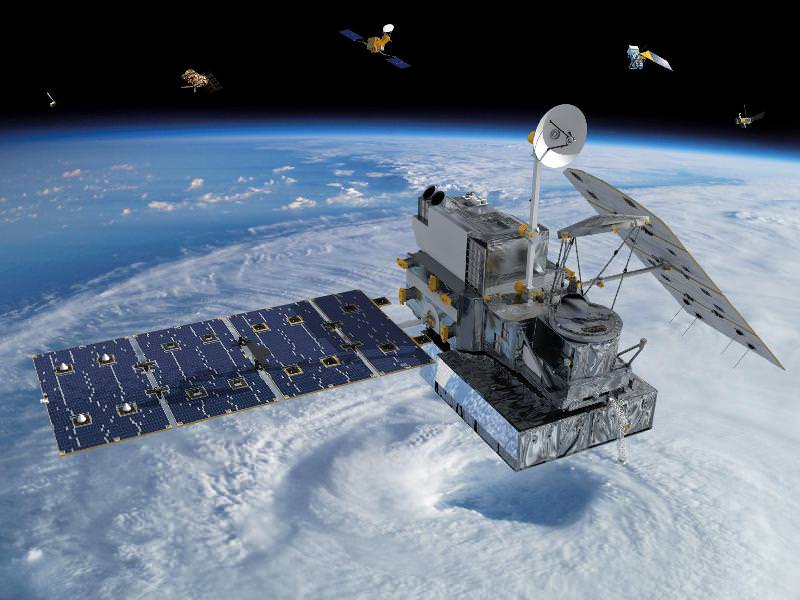
Visualization of the GPM Core Observatory and Partner Satellites. GPM is slated to launch on Feb. 27 from Japan. Credit: NASA
See launch animation, Shinto ceremony, Rocket roll out and more below[/caption]

NASA GODDARD SPACE FLIGHT CENTER, MARYLAND – Blastoff of the powerful and revolutionary new NASA/JAXA rain and snow precipitation measurement satellite atop a Japanese rocket from a tiny offshore island launch pad is now less than 24 hours away on Thursday, Feb. 27, EST (Feb. 28 JST).

The Global Precipitation Measurement (GPM) Core Observatory aimed at improving forecasts of extreme weather and climate change research has been given a green light for launch atop a Mitsubishi Heavy Industries H-IIA rocket from the Tanegashima Space Center on Tanegashima Island off southern Japan.

Roll out of the H-IIA launch vehicle from the Vehicle Assembly Building is scheduled for this evening, Feb. 26 at 11 p.m. EST.

Update: rocket rolled out. Photo below, plus watch streaming NASA TV below.

Following the Launch Readiness Review, mission managers approved the GO for liftoff.

The H-IIA rocket with GPM rolls to its launch pad in Japan! Credit: NASA/Bill Ingalls

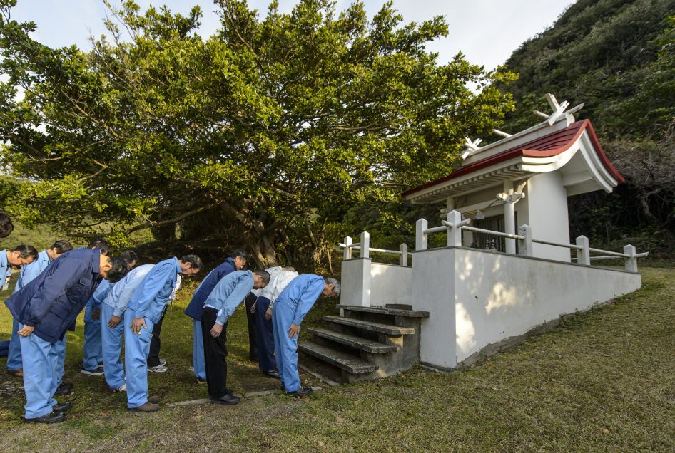
Japanese team members also prayed at a Shinto ceremony for blessings for a successful launch at the Ebisu Shrine, the first shrine in a traditional San-ja Mairi, or Three Shrine Pilgrimage on Tuesday, Feb. 25, 2014 – see photo below.

However, the team also set a newly revised launch time of 1:37 p.m. EST (18:37 UTC, and Feb. 28 at 3:37 a.m. JST).


Live streaming video by Ustream

Mission managers adjusted the H-IIA launch time after concerns raised by a collision avoidance analysis between the GPM spacecraft and the International Space Station (ISS).

gpm launch

GPM will fly at an altitude of 253 miles (407 kilometers) above Earth – quite similar to the ISS.

It’s coverage runs over virtually the entire populated globe from 65 N to 65 S latitudes.

NASA plans live coverage of the launch on Feb. 27 beginning at 12 noon EST on NASA Television.

It will be streamed live at: http://www.nasa.gov/nasatv

The $933 Million observatory is a joint venture between the US and Japanese space agencies, NASA and the Japan Aerospace Exploration Agency (JAXA).

NASA’s next generation Global Precipitation Measurement (GPM) observatory inside the clean room at NASA Goddard Space Flight Center, MD. Technicians at work on final processing during exclusive up-close inspection tour by Universe Today.  GPM is slated to launch on February 27, 2014 and will provide global measurements of rain and snow every 3 hours. Credit: Ken Kremer/kenkremer.com
NASA’s next generation Global Precipitation Measurement (GPM) observatory inside the clean room at NASA Goddard Space Flight Center, MD. Technicians at work on final processing during exclusive up-close inspection tour by Universe Today. GPM is slated to launch on February 27, 2014 and will provide global measurements of rain and snow every 3 hours. Credit: Ken Kremer/kenkremer.com

GPM has a one-hour launch window. In case of any delays, the team will be required to conduct a thorough new collision avoidance analysis to ensure safety.

Weather forecast is excellent at this time.

Watch this GPM Launch animation:

Video caption: NASA/JAXA GPM Core Observatory Launch Animation

GPM is a next-generation satellite that will provide global, near real time observations of rain and snow from space. Such data is long awaited by climate scientists and weather forecasters.

It will open a new revolutionary era in global weather observing and climate science. Therefore it will have a direct impact on society and people’s daily lives worldwide.

The mission will significantly advance our understanding of Earth’s water and energy cycles and improve forecasting of extreme weather events.

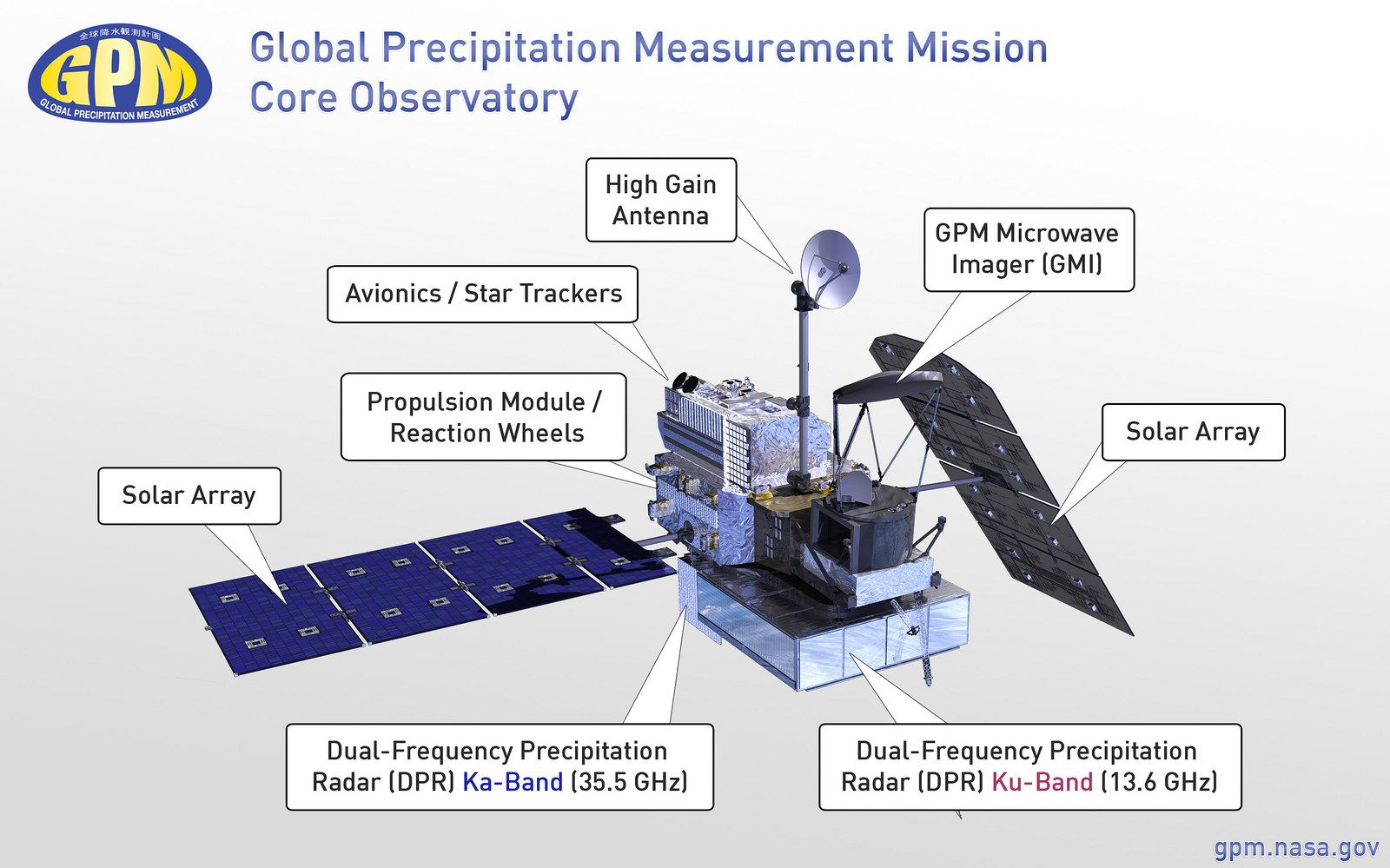
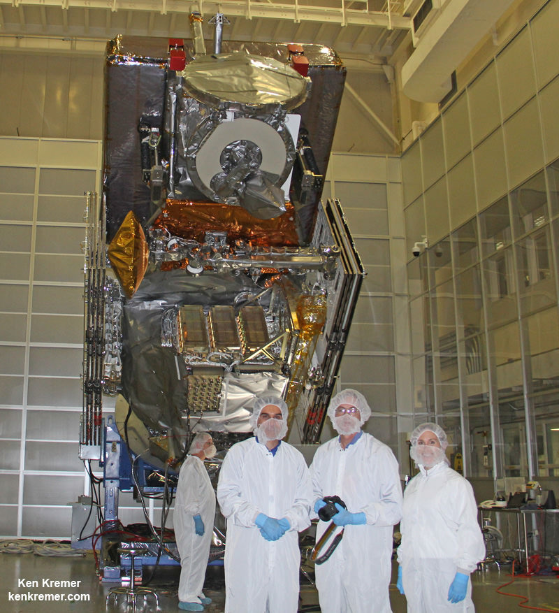
The 3850 kilogram GPM satellite is equipped with two instruments – an advanced, higher resolution dual -frequency precipitation (DPR) radar instrument (Ku and Ka band) built by JAXA in Japan and the GPM microwave imager (GMI) built by Ball Aerospace in the US.

Major components of the GPM Core Observatory labeled, including the GMI, DPR, HGAS, solar panels, and more. Credit: NASA Goddard

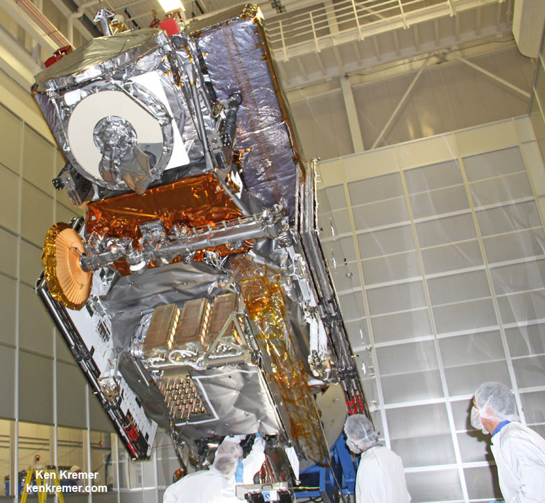
“The GPM satellite was built in house at NASA’s Goddard Space Flight Center in Maryland,” Art Azarbarzin, GPM project manager, told Universe Today during my exclusive up-close clean room inspection tour of the huge satellite as final processing was underway.

Researchers will use the GPM measurements to study climate change, freshwater resources, floods and droughts, and hurricane formation and tracking.

“GPM will join a worldwide constellation of current and planned satellites,” Azarbarzin told me during an interview in the Goddard cleanroom beside GPM.

“GPM is the direct follow-up to the currently orbiting TRMM satellite,” Azarbarzin explained.

“TRMM is reaching the end of its usable lifetime. After GPM launches we hope it has some overlap with observations from TRMM.”

“The Global Precipitation Measurement (GPM) observatory will provide high resolution global measurements of rain and snow every 3 hours,” Dalia Kirschbaum, GPM research scientist, told me during an interview at Goddard.

Stay tuned here for Ken’s continuing GPM reports and on-site coverage at NASA Goddard Space Flight Center in Maryland.

And watch for Ken’s continuing planetary and human spaceflight news about Curiosity, Opportunity, Chang’e-3, SpaceX, Orbital Sciences, LADEE, MAVEN, MOM, Mars, Orion and more.

Ken Kremer

GPM: Three Shrine Pilgrimage  Japan Aerospace Exploration Agency (JAXA) team members bow at the Ebisu Shrine, the first shrine in a traditional San-ja Mairi, or Three Shrine Pilgrimage, where the team prays on Tuesday, Feb. 25, 2014 for a successful launch, Tanegashima Island, Japan.    Credit: NASA/Bill Ingalls
GPM: Three Shrine Pilgrimage Japan Aerospace Exploration Agency (JAXA) team members bow at the Ebisu Shrine, the first shrine in a traditional San-ja Mairi, or Three Shrine Pilgrimage, where the team prays on Tuesday, Feb. 25, 2014 for a successful launch, Tanegashima Island, Japan. Credit: NASA/Bill Ingalls
NASA/JAXA Global Precipitation Measurement (GPM) satellite inside the clean room at NASA Goddard Space Flight Center, MD, undergoes final processing during exclusive up-close inspection tour by Universe Today:   Dr. Art Azarbarzin/NASA GPM project manager, Dr. Ken Kremer/Universe Today and Dr. Dalia Kirschbaum/NASA GPM research scientist.    Credit: Ken Kremer/kenkremer.com
NASA/JAXA Global Precipitation Measurement (GPM) satellite inside the clean room at NASA Goddard Space Flight Center, MD, undergoes final processing during exclusive up-close inspection tour by Universe Today: Dr. Art Azarbarzin/NASA GPM project manager, Dr. Ken Kremer/Universe Today and Dr. Dalia Kirschbaum/NASA GPM research scientist. Credit: Ken Kremer/kenkremer.com

Volcanic Blast Forms New Island Near Japan

An erupting undersea volcano forms a new island off the coast of Nishinoshima, a small unihabited island in the southern Ogasawara chain of islands. The image was taken on November 21, 2013 by the Japanese Coast Guard.

A volcanic eruption is creating a tiny new island off the coast of Japan. The Japanese Coast Guard snapped images and video of the eruption taking place, showing the new island being formed. Footage showed heavy smoke, ash and rocks spewing from the volcanic crater. As of this writing, experts say the small island is about 200 meters (660 feet) in diameter. It is located just off the coast of Nishinoshima, a small, uninhabited island in the Ogasawara chain, also known as the Bonin Islands, about about 620 miles (1,000 km) south of Tokyo.

See a video and additional images below.

Only time will tell if the island will remain or if the ocean waters will reclaim it. According to Yahoo News, Japan’s chief government spokesman said they would welcome any new territory.

“This has happened before and in some cases the islands disappeared,” Yoshihide Suga said when asked if the government was planning on naming the new island. “If it becomes a full-fledged island, we would be happy to have more territory.”

An erupting undersea volcano forms a new island, shown by its nearest neighbor, Nishinoshima, a small unihabited island in the southern Ogasawara chain of islands. The image was taken on November 21, 2013 by the Japanese Coast Guard.
This screenshot of Google Maps shows all the volcanoes in the The Japan, Taiwan, Marianas Region. Via Google Maps and the Smithsonian volcano website.

According to the Smithsonian Global Volcanism Program website, the Japan, Taiwan, Marianas Region is a very active region in the Pacific Ring of Fire and most volcanoes in this region “result from subduction of westward-moving oceanic crust under the Asian Plate. In the Izu-Mariana chain, however, the crust to the west is also oceanic, forming more basaltic island arcs (but with volcanoes that are far more explosive than oceanic hotspot volcanoes).”

You can read more about this volcanic region here.

See an extensive gallery of images at Yahoo News.

Japanese ‘Space Cannon’ On Track For Aiming At An Asteroid: Reports

Painting of Asteroid 2012 DA14. © David A. Hardy/www.astroart.org

Watch out, asteroid 1999 JU3: you’re being targeted. As several media reports reminded us, the Japan Aerospace Exploration Agency (JAXA)’s Hayabusa-2 asteroid exploration mission will carry a ‘space cannon’ on board — media-speak for the “collision device” that will create an artificial crater on the asteroid’s surface.

“An artificial crater that can be created by the device is expected to be a small one with a few meters in diameter, but still, by acquiring samples from the surface that is exposed by a collision, we can get fresh samples that are less weathered by the space environment or heat,” JAXA states on its website.

Reports indicate JAXA is on schedule to, er, shoot this thing into space for a 2018 rendezvous with an asteroid. The spacecraft will stick around the asteroid for about a year before heading back to Earth in 2020. The overall aim is to learn more about the origin of the solar system by looking at a C-type asteroid, considered to be a “primordial body” that gives us clues as to the early solar system’s makeup.

Check out more on Hayabusa-2 on JAXA’s website.

Best-Ever Topographic Map of Earth from NASA and Japan

At 4.4 kilometers in elevation, California's Mt. Whitney is the highest point in the continental United States. Image credit: NASA/GSFC/METI/ERSDAC/JAROS, and U.S./Japan ASTER Science Team

[/caption]NASA and Japan recently announced a new and improved digital topographic map of Earth, which was produced with detailed measurements from NASA’s Terra spacecraft.

The new data covers over 99 percent of Earth’s landmass and spans from 83 degrees north latitude to 83 degrees south. Each elevation measurement point in the data is only 30 meters apart.

How were scientists able to improve on previous generations of detailed topographic maps?


The new model, known as a global digital elevation model, was created from images collected by the Japanese Advanced Spaceborne Thermal Emission and Reflection Radiometer, or ASTER, instrument aboard NASA’s Terra spacecraft. To create a “stereo pair” image,scientists can take two slightly offset images and combine them to create a three-dimensional effect of depth.

The previous version of the global digital elevation model was released in June of 2009 by NASA and Japan’s Ministry of Economy, Trade and Industry.

“The ASTER global digital elevation model was already the most complete, consistent global topographic map in the world,” said ASTER program scientist Woody Turner, “With these enhancements, its resolution is in many respects comparable to the U.S. data from NASA’s Shuttle Radar Topography Mission, while covering more of the globe.”

The ASTER team added 260,000 stereo-pair images to improve the previous model, which improved spatial resolution, increased horizontal and vertical accuracy, and provided the ability to identify lakes as small as 1 kilometer in diameter.

“This updated version of the ASTER global digital elevation model provides civilian users with the highest-resolution global topography data available,” said ASTER science team lead Mike Abrams. “These data can be used for a broad range of applications, from planning highways and protecting lands with cultural or environmental significance, to searching for natural resources.”

Arguably one of America's most magnificent national parks is the Grand Canyon in northern Arizona. Image credit: NASA/GSFC/METI/ERSDAC/JAROS, and U.S./Japan ASTER Science Team

Joining together in a collaborative effort, NASA and METI are contributing data for the ASTER topographic map to the Group on Earth Observations, for use in the group’s Global Earth Observation System of Systems. No, the previous statement wasn’t a typo – the “system of systems” is an international effort, which uses shared Earth observation data to help monitor and forecast global environmental changes.

One of five instruments launched on Terra in 1999, ASTER acquires images from visible to thermal infrared wavelengths, with spatial resolutions ranging from about 15 to 90 meters. ASTER’s science team is a joint effort between the United States and Japan.

The ASTER data was validated by NASA, METI, Japan’s Earth Remote Sensing Data Analysis Center (ERSDAC), and the U.S. Geological Survey, with additional support from the U.S. National Geospatial-Intelligence Agency and other collaborators. NASA’s Land Processes Distributed Active Archive Center is handling the distribution of the new ASTER global digital elevation model.

If you’d like to download the ASTER global digital elevation model to study at no cost, you can do so at: https://lpdaac.usgs.gov/ or http://www.ersdac.or.jp/GDEM/E/4.html

To learn more about ASTER, or NASA’s Terra mission, visit: http://asterweb.jpl.nasa.gov/ and http://www.nasa.gov/terra

Source: NASA/JPL Press Release

Equipment to Study Hayabusa’s Asteroid Samples Damaged in Japan Earthquake

Magnified view of a dust particle in the Hayabusa canister. Credit: JAXA

[/caption]

The large particle accelerator being used in to analyze the asteroid samples returned by the Hayabusa spacecraft was damaged by the March 11 earthquake in Japan, but the high energy accelerator at the KEK particle-physics laboratory will be repaired, according to this report on a Japanese website. An announcement on the KEK website said that all accelerators and experimental devices were stopped immediately “after the first shake” of the historic earthquake. “We have confirmed the radiation safety, and no hazard to the environment has been reported,” the announcement said. “Also there are no reports of casualties on both Tsukuba and Tokai campuses.” Tsukuba is in the mid-latitudes of Japan, about 50 km from Tokyo.

Apparently, the tiny asteroid particles are safe, but an official at KEK was quoted as saying (via Google Translate) “The accelerator needs to be adjusted very precisely. To suffer this much, but it takes time to recover, want to lose to the earthquake recovery.”

But the repairs to the accelerator may take a back seat to the current situation in Japan. The city of Tsukuba is going to take in refugees from Fukushima prefecture, where the heavily damaged nuclear reactor is located and the KEK facilities will provide support for radiation screening for the refugees upon their arrival.

This photo shows some of the damage to the Tsukuba Space Center in Tsukuba, Japan, the main space center for the country's JAXA agency, from the 8.9-magnitude earthquake that struck on March 11, 2011. Credit: collectSPACE.com

Tsukuba is also home to the space center that oversees Japan’s Kibo laboratory on the International Space Station, as well the JAXA’s unmanned cargo ships that deliver supplies on orbit. The space center was slightly damaged, and for awhile NASA’s Mission Control in Houston took over operations remotely. According to Robert Pearlman on collectSPACE, several of the Japanese flight control team members and flight directors from the Tsukuba Space Center happened to be in Houston when the quake struck, preparing for the Expedition 27 crew rotation, as astronaut Satoshi Furukawa will be heading the ISS in May. However, operations from the mission control rooms were resumed at 4:00 p.m. on March 22, 2011.

JAXA Flight Control Team (JFCT) resuming the Kibo operations at the Mission Control Room (MCR). Credit: JAXA

Another center, the Kakuda Space Center, located in the Miyagi region close to the most serious effects of the earthquake and tsunami, was heavily damaged, and is closed with no timetable for reopening. The Kakuda center is JAXA’s rocket development and testing center and is Japan’s equivalent of the Stennis Space Center in Mississippi.

JAXA’s Tsukuba Space Center located in Tsukuba Science City,

Additionally, the ground-breaking ceremony for a new type of particle smasher known as a “super B factory” in Tsukuba has been postponed. Japan had invested $100 million to transform the KEKB collider in Tsukuba, into a Super KEKB, which will smash electrons into positrons at 40 times the rate of the current accelerator.
Just before the quake, the Japanese Space Agency JAXA had announced they are planning a second Hayabusa mission with an explosive twist. The second mission to an asteroid probe will include an impactor that detonates an explosive on the asteroid’s surface, similar to the Deep Impact mission.

The launch was tentatively planned for launch in 2014, heading to a space rock catalogued as 162173 1999 JU3. The probe would land on the surface and, collect samples before and after the impactor blasts its way to the asteroid’s interior.

Despite the problems Hayabusa encountered along its arduous journey to and from asteroid Itokawa –including thruster, communications, gyro and fuel-leak problems, as well as uncertainty whether the probe landed on the asteroid – JAXA and the Japanese people were buoyed by the success of Hayabusa.

It is not clear how the tragic earthquake and tsunami will affect future space missions for Japan, but obviously the country has more important issues ahead of them. May the spirit of the Japanese people be lifted again.

Sources: NHK,, KEK , collectSPACE, Moon and Back, JAXA

Hat tip to Emily Lakdawalla via Twitter.

Satellite Photos Before and After of Japan’s Earthquake, Tsunami

Sendai, Japan after the disaster. Satellite image courtesy of GeoEye.

[/caption]

Photos from the GeoEye satellite imaging company from before and after the March 11 earthquake and tsunami in Japan show sobering views from above of the disaster. Above is the town of Sendai, Japan after the quake, below is how it looked before catastrophe struck.

Arahama, Japan before the disaster. Satellite image courtesy of GeoEye.

See more below.

The Sendai Airport after the disaster. Satellite image courtesy of GeoEye.
The Sendai Airport in August of 2010. Satellite image courtesy of GeoEye.
Yuriage, Japan on March 12, 2011. Satellite image courtesy of GeoEye.
Yuriage, Japan on April 4, 2010. Satellite image courtesy of GeoEye.
Sendai, Japan on March 12, 2011. Satellite image courtesy of GeoEye.
Sendai, Japan on April 4, 2010. Satellite image courtesy of GeoEye.
Ishinomaki, Japan on March 12, 2011. Satellite image courtesy of GeoEye.
Ishinomaki, Japan on April 4, 2010. Satellite image courtesy of GeoEye.

Below is an images from the MODIS Rapid Response System, which is producing twice-daily images of Japan in response to the disaster.

The Moderate Resolution Imaging Spectroradiometer (MODIS) on NASA’s Aqua satellite took the right image on Mar. 13, 2011, while the MODIS sensor on NASA’s Terra satellite took the left image on Feb 26, 2011. NASA images courtesy the MODIS Rapid Response Team at NASA GSFC.

These two images, from the MODIS instrument on NASA’s Aqua satellite from Mar. 13, 2011 on the right, and the the MODIS sensor on NASA’s Terra satellite from Feb. 26, 2011 on the left before the earthquake and tsunami. Both images were made with infrared and visible light to highlight the presence of water on the ground. Plant-covered land is bright green, bare earth is tan-pink, and snow is blue. The city of Sendai is brown.

At this level of detail, the flooding along the coastline is the most obvious sign of the destructive earthquake and tsunami that struck Japan on March 11. A bright orange-red spot near the city of Sendai is the thermal signature from a fire, also likely caused by the earthquake. The photo-like true-color version of the image shows a plume of black smoke extending east over the ocean.

The German Aerospace Center (Deutsches Zentrum fur Luft- und Raumfahrt; DLR) is responding through its Center for Satellite Based Crisis Information (Zentrum fur Satellitengestutzte Kriseninformation; ZKI), based at its site in Oberpfaffenhofen, and provided the image below.

Japan's Coastline Before and After the Tsunami These images show the effects of the tsunami on Japan's coastline. The image on the left was taken on Sept. 5, 2010; the image on the right was taken on March 12, 2011, one day after an earthquake and resulting tsunami struck the island nation. Image Credit: German Aerospace Center (DLR)/Rapid Eye

Sources: GeoEye, New York Times, NASA, Space Daily

Long Duration Space Underwear

Koichi Wakata on board the ISS. Credit: NASA

[/caption]
As Japan’s first astronaut to spend long duration missions on board the International Space Station, Koichi Wakata has had the opportunity to do all sorts of interesting experiments the past few months. For example, he conducted several different cellular growth and crystal growth experiments, and has even flown a magic carpet in space. One other experiment has been – shall we say – kept under wraps. Wakata has been wearing the same underwear on board the ISS for two months.

“(For) two months I was wearing these underwear and there was no smell and nobody complained,” Wakata, speaking in Japanese, said through an interpreter during a press conference this weekend from the ISS. “I think that new J-ware underwear is very good for myself and my colleagues.”

Wakata has been wearing special underwear and other clothing called “J-ware” designed for the Japanese space agency. According to an article in Discovery News, the clothes are treated with antibacterial and deodorizing materials. In addition to odor control, the clothes are designed to absorb water, insulate the body and dry quickly. They also are flame-resistant and anti-static — as well as comfortable and attractive.

Typically, clothes can only be worn for a few days in space, and especially the clothing worn by astronauts as they exercise. Since there’s no laundromat in space, the clothing is discarded as garbage.

Astronaut Takao Doi, who flew with a shuttle crew last year to deliver Japan’s Kibo laboratory to the station, exercised as much as his crewmates, but his clothes stayed dry.

Wakata’s clothes include long- and short-sleeved shirts, pants, shorts and underwear. Special socks have a separate pouch for the big toes so the astronauts can use their feet like an extra pair of hands, helpful for anchoring themselves on the floor while doing work on the station.

Originally, Wakata was scheduled to wear the underwear for just a couple of weeks. But obviously, he decided to go the long duration route.

Proposed Japanese space toilet.  Credit: JAXA
Proposed Japanese space toilet. Credit: JAXA

At least he wasn’t testing this other option proposed by JAXA. Read more about these special underwear here.

Wakata heads home with the crew of the STS-127 mission, undocking from the ISS today. The first landing opportunity is Friday, July 31.

Sources: Discovery News, Free Space

Last Kaguya HDTV Images Before Impact

One of the last images taken by Kaguya before it impacted the Moon on June 11, 2009. Credit: JAXA

[/caption]
The Japan Aerospace Exploration Agency (JAXA) has released the final still images taken by the onboard High Definition Television (HDTV) from Kaguya, just before it completed its mission by impacting the moon on June 11, 2009. An entire series of images were taken with an interval of about one minute by the HDTV (Teltephoto) while Kaguya maneuvered its way to impact in Gill Crater.

Here’s a link to a Flash animation showing the images in succession. Click the “up” arrow to proceed through the images.

The last image taken is basically just black as it approached the darkened bottom of the crater. This is the second to the last image taken:

Kaguya 2nd to last image. Credit: JAXA

Visible is the surface of the Moon getting closer as Kaguya approached impact.

Kaguya launched on September 14, 2007 and spent nearly two years studying the moon before the planned impact. An Australian telescope observed the controlled crash of Japan’s Kaguya lunar probe into the moon Wednesday, an important warm-up act before a NASA’s LCROSS impactor attempts a similar feat in October. Here’s the series of images from Australia:

The image above shows a sequence of four frames around the impact time, with a bright impact flash visible in the second frame, and faintly seen in the third and fourth. Credit: Anglo-Australian Telescope by Jeremy Bailey (University of New South Wales) and Steve Lee (Anglo-Australian Observatory)

Browse through more images taken by the Kaguya HDTV Archives, the JAXA digital archives,, and the JAXA channel on YouTube.

Hat tip to Joel Raupe at Lunar Networks

Hinode Discovers the Sun’s Hidden Sparkle

hinode_xray_jet.thumbnail.jpg

Blinking spots of intense light are being observed all over the lower atmosphere of the Sun. Not just in the active regions, but in polar regions, quiet regions, sunspots, coronal holes and loops. These small explosions fire elegant jets of hot solar matter into space, generating X-rays as they go. Although X-ray jets are known to have existed for many years, the Japanese Hinode observatory is seeing these small flares with unprecedented clarity, showing us that X-ray jets may yet hold the answers to some of the most puzzling questions about the Sun and its hot corona.

Although a comparatively small mission (weighing 875 kg and operating just three instruments), Hinode is showing the world some stunning high resolution pictures of our nearest star. In Earth orbit and kitted out with an optical telescope (the Solar Optical Telescope, SOT), Extreme ultraviolet Imaging Spectrometer (EIS) and an X-Ray Telescope (XRT), the light emitted from the Sun can be split into its component optical, ultraviolet and X-ray wavelengths. This in itself is not new, but never before has mankind been able to view the Sun in such detail.

It is widely believed that the violent, churning solar surface may be the root cause of accelerating the solar wind (blasting hot solar particles into space at a mind-blowing 1.6 million kilometers per hour) and heating the million plus degree solar atmosphere. But the small-scale processes close to the Sun driving the whole system are only just beginning to come into focus.

Up until now, small-scale turbulent processes have been impossible to observe. Generally, any feature below 1000 km in size has remained undetected. Much like trying to follow a golf ball in flight from 200 meters away, it is very difficult (try it!). Compare this with Hinode, the same golf ball can be resolved by the SOT instrument from nearly 2000 km away. That’s one powerful telescope!

The limit of observable solar features has now been lifted. The SOT can resolve the fine structure of the solar surface to 180 km, this is an obvious improvement. Also, the EIS and XRT can capture images very quickly, one per second. The SOT can produce hi-res pictures every 5 minutes. Therefore, fast, explosive events such as flares can be tracked easier.

Putting this new technology to the test, a team led by Jonathan Cirtain, a solar physicist at NASA’s Marshall Space Flight Center, Huntsville, Alabama, has unveiled new results from research with the XRT instrument. X-ray jets in the highly dynamic chromosphere and lower corona appear to occur with greater regularity than previously thought.

X-ray jets are very important to solar physicists. As magnetic field lines are forced together, snap, and form new configurations, vast quantities of heat and light are generated in the form of a “microflare”. Although these are small events on a solar scale, they still generate huge amounts of energy, heating solar plasma to over 2 million Kelvin, create spurts of X-ray emitting plasma jets and generate waves. This is all very interesting, but why are jets so important?

The solar atmosphere (or corona) is hot. In fact, very hot. Actually, it is too hot. What I’m trying to say is that measurements of coronal particles tell us the atmosphere of the Sun is actually hotter than the Suns surface. Traditional thinking would suggest that this is wrong; all sorts of physical laws would be violated. The air around a light bulb isn’t hotter than the bulb itself, the heat from an object will decrease the further away you measure the temperature (obvious really). If you’re cold, you don’t move away from the fire, you get closer to it!

The Sun is different. Through interactions near the surface of the Sun between plasma and magnetic flux (a field known as “magnetohydrodynamics” – magneto = magnetic, hydro = fluid, dynamics = motion: “magnetic-fluid-motion” in plain English, or “MHD” for short), MHD waves are able to propagate and heat up the plasma. The MHD waves under scrutiny are known as “Alfvén wavesâ€? (named after Hannes Alfvén, 1908-1995, the plasma physics supremo) which, theoretically, carry enough energy from the Sun to heat the solar corona hotter than the solar surface. The one thing that has dogged the solar community for the last half a century is: how are Alfvén waves produced? Solar flares have always been a candidate as a source, but observation suggested that there wasn’t enough flares to generate enough waves. But now, with advanced optics used by Hinode, many small-scale events appear to be common… bringing us back to our X-ray jets…

Previously, only the largest X-ray jets have been observed, putting this phenomenon at the bottom of the priority list. NASA’s Marshall Space Flight Center group has now turned this idea on its head by observing hundreds of jet events each and every day:

“We now see that jets happen all the time, as often as 240 times a day. They appear at all latitudes, within coronal holes, inside sunspot groups, out in the middle of nowhere–in short, wherever we look on the sun we find these jets. They are a major form of solar activity” – Jonathan Cirtain, Marshall Space Flight Center.

So, this little solar probe has very quickly changed our views on solar physics. Launched on September 23, 2006, by a consortium of countries including Japan, USA and Europe, Hinode has already revolutionized our thinking about how the Sun works. Not only looking deep into the chaotic processes in the solar chromosphere, it is also finding new sources where Alfvén waves may be generated. Jets are now confirmed as common events that occur all over the Sun. Could they provide the corona with enough Alfvén waves to heat the Sun’s corona more than the Sun itself? I don’t know. But what I do know is, the sight of solar jets flashing to life in these movies is awesome, especially as you see the jet launch into space from the original flash. This is also a very good time to be seeing this amazing phenomenon, as Jonathan Cirtain points out the site of solar jets reminds him of “the twinkle of Christmas lights, randomly oriented. It’s very pretty”. Even the Sun is getting festive.