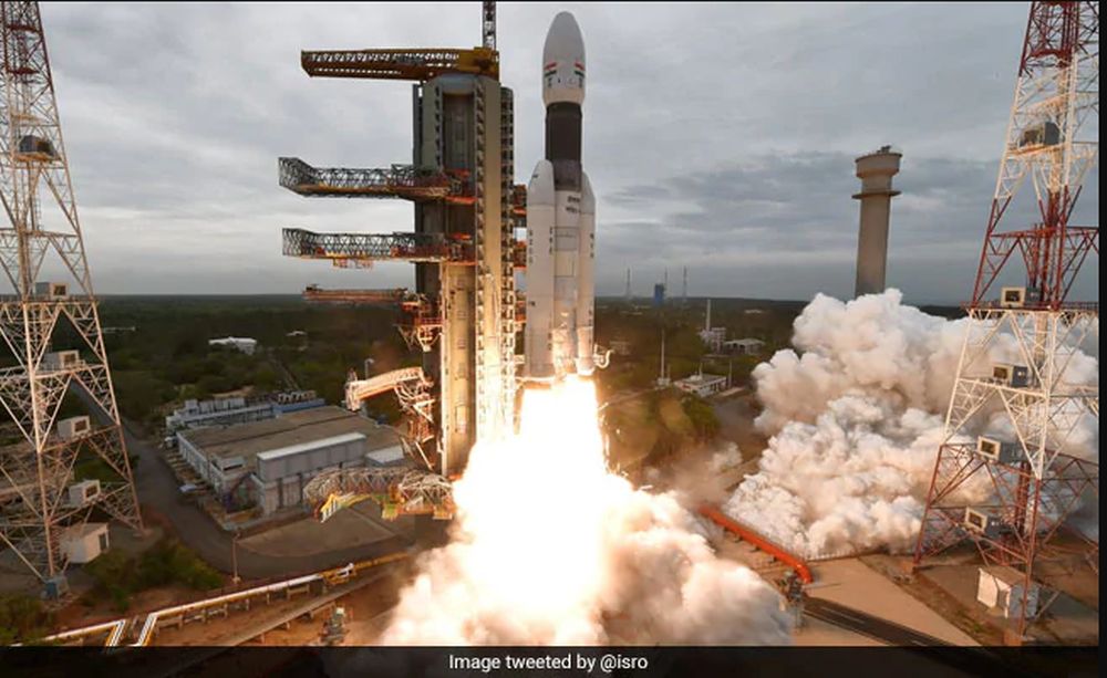
Reflecting its growth as a global power, India has achieved some impressive progress in space lately. In the past decade, the Indian Space Research Organization (ISRO) has sent robotic spacecraft into orbit, to the Moon, and also to Mars. And today, they made their first attempt at a soft lunar landing by sending the Vikram lander towards the surface of the Moon.
This move would have made India the fourth nation in the world to land a spacecraft on the lunar surface. The landing sequence went as planned until the lander reached an altitude of 2.1 km (1.3 mi) above the surface. Unfortunately, communications with the lander was lost at that point and it is unclear whether the lander crashed. At the moment, the ISRO is analyzing data collected by the orbiter to determine what happened.
India's Chandrayaan-2 launching to the Moon on July 22nd. Image Credit: ISRO
ISRO (Indian Space Research Organization) has successfully launched their Chandrayaan-2 mission to the Moon. The mission, which includes an orbiter, a lander, and a rover, was launched into space on a GSLV Mk III rocket on July 22nd, after a week-long delay. On September 7th it will perform a soft-landing on the Moon.
Graphic showing the cloud of space debris that currently surrounds the Earth. Credit: NASA's Goddard Space Flight Center/JSC
Last week, in a move that left many perplexed, the nation of India destroyed one of its own satellites. According to a statement made by Prime Minister Narendra Modi, this operation (“Mission Shakti”) was conducted using a new type of anti-satellite missile. With this one act, Modi claimed that India had “established itself as a space power”, effectively joining the United States, Russia and China.
Unfortunately, this demonstration has created a cloud of orbital debris in Low Earth Orbit (LEO). According to a recent statement made by NASA Administrator Jim Bridenstine, this debris poses an “unacceptable” threat to the International Space Station. In this sense, by flexing its muscle as a space power, India may have caused some serious disruption to international efforts in space.
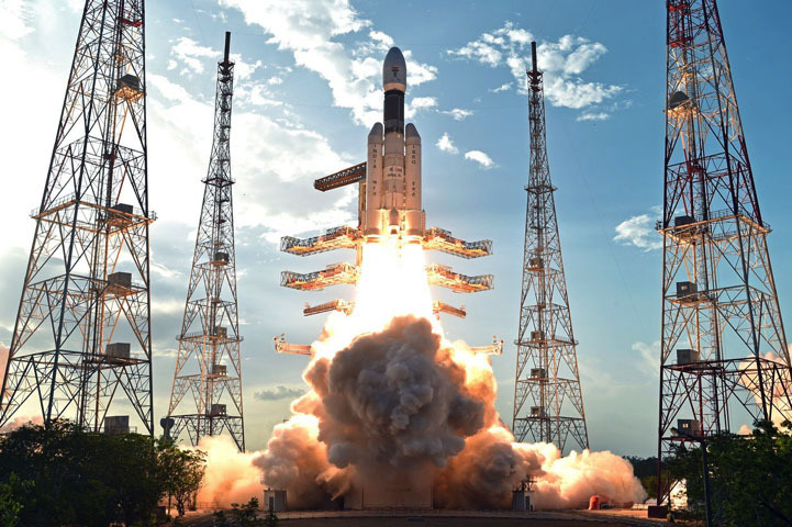
GSLV-MK3-D1 lifting off from its launch pad at the Satish Dhawan Space Center. Credit: ISRO
One of the most notable features of the modern space age is the way that new participants are entering the fray. In addition to the traditional contenders – NASA and Roscosmos – China has become a major player in space in recent decades. And in 2022, according tor recent statements, India will join the club too when it becomes the fourth nation to send a crewed mission to space.
During a cabinet-level meeting that took place on Friday, Dec. 25th, the government of India announced that the Indian Space Research Organization‘s (ISRO) first crewed mission to space will consist of a three-astronaut team being sent to orbit. The government also announced that they had a approved a budget of $1.4 billion to fund the development of the requisite technology and infrastructure for the program.
The ISRO recently unveiled the spacesuit that the first crewed mission to space would be wearing. Credit: ISRO
The Indian Space Research Organization (ISRO) has made immense progress since the turn of the century. From its humble beginnings, launching satellites into orbit between 1975 and 2000, the ISRO sent their first mission to the Moon in October of 2008 (the Chandrayaan-1 orbiter), followed by their first mission to Mars – the Mars Orbiter Mission (MOM) – in November of 2013.
And in the coming years, the ISRO intends to become the fourth space agency to send astronauts into space. In so doing, they will join an exclusive club of space agencies that consists of only Russia, the United States and China. Last week (on September 7th, 2018) the organization unveiled the spacesuit that their astronauts will be wearing when they make this historic journey.
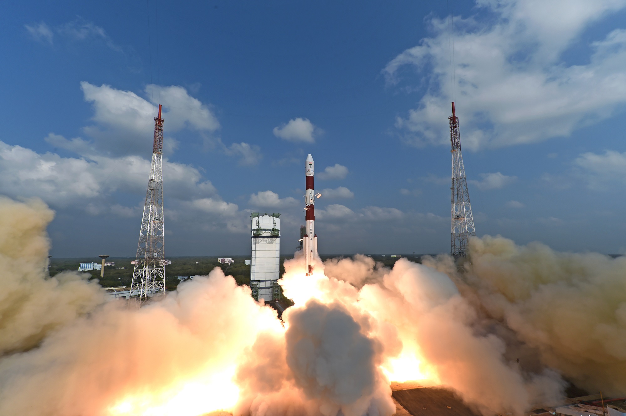
The thirty-ninth flight of the ISRO's Polar Satellite Launch Vehicle (PSLV-C37), which successfully from Satish Dhawan Space Centre SHAR, Sriharikota on February 15th, 2017. Credit: ISRO
India’s national space agency – the Indian Space Research Organization (ISRO) – has come a long way in recent years. In 2008, the agency launched its first lunar explorer, Chandrayaan-1, which also deployed a lander (the Moon Impact Probe) to the surface. And then there was the Mangalayaan mission – aka. the Mars Orbiter Mission (MOM) – which made history on Sept. 24th, 2014, when it became the first probe to enter orbit around Mars on the first try.
In their latest feat, the ISRO established a new record for the number of satellites launched in a single mission. In what was the thirty-ninth launch of the Polar Satellite Launch Vehicle (PSLV), the organization deployed 104 satellites into orbit. In so doing, they have effectively overtaken the previous record of 37 – which was established by Roscosmos in June of 2014.
This launch was also the thirty eighth successful mission in a row for the PSLV. which has been in service since the early 1990s. Prior to this flight, the rocket had successfully launched a total of 71 satellites and spacecraft – 31 of which were Indian – into a variety of orbits. The most satellites it launched at one time was 20, which took place on June 22nd, 2016, with the launch of the PSLV-C34 mission.
The thirty-sixth launch of the ISROs India’s Polar Satellite Launch Vehicle (PSLV-C34), in June 2016. Credit: ISRO
Hence, it has not only beaten its own record this single launch (and by a factor of five, no less), but more than doubled the total amount of satellites it has deployed. This mission also pushed the total number of Indian-made satellites sent into space aboard the PSLV rocket to 46, and the number of customer satellites that India has launched to 180.
“PSLV-C37 lifted off at 0928 hrs (9:28 am) IST, as planned, from the First Launch Pad. After a flight of 16 minutes 48 seconds, the satellites achieved a polar Sun Synchronous Orbit of 506 km inclined at an angle of 97.46 degree to the equator (very close to the intended orbit) and in the succeeding 12 minutes, all the 104 satellites successfully separated from the PSLV fourth stage in a predetermined sequence beginning with Cartosat-2 series satellite, followed by INS-1 and INS-2.”
Shortly after the launch, Prime Minister Narendra Modi, took to Twitter to congratulate the scientists and laud the space agency for its record-breaking accomplishment. “This remarkable feat by @isro is yet another proud moment for our space scientific community and the nation. India salutes our scientists,” he tweeted. “Congratulations to @isro for the successful launch of PSLV-C37 and CARTOSAT satellite together with 103 nano satellites!”
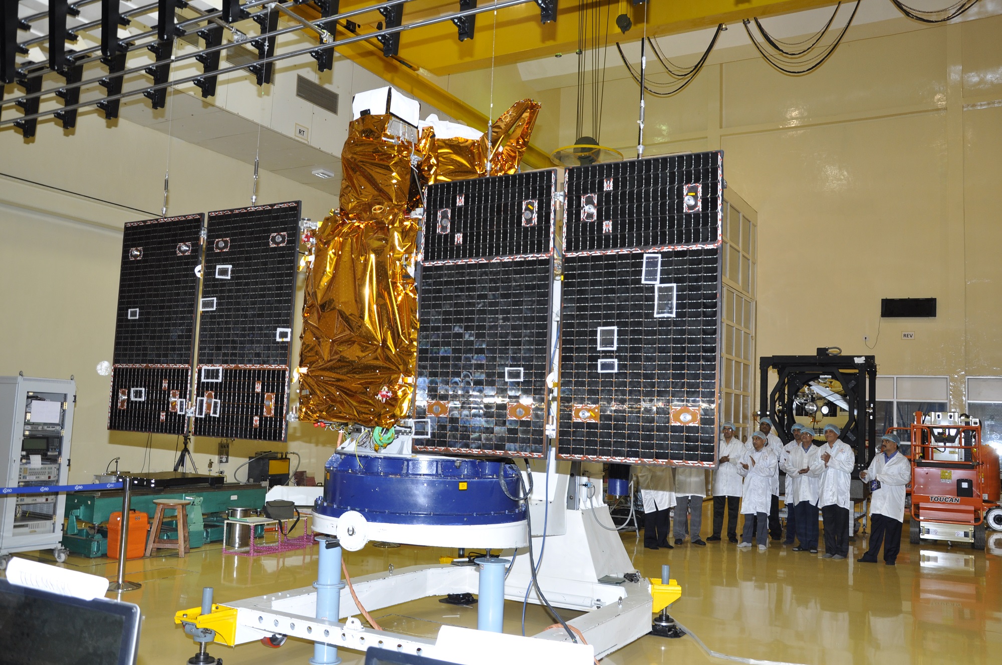
A Cartosat-2 Series Satellite undergoing a panel deployment test at ISAC Bengaluru. Credit: ISRO
The cargo consisted of a Cartosat-2 Series Satellite, which is the latest in a series of ISRO Earth-observation satellites. In the coming days, the satellite will position itself and begin to provide remote sensing services using its state-of-the-art panchromatic (PAN) camera – which takes black and white pictures of the Earth in the visible and EM spectrum – and its multi-spectral (color) cameras.
In addition, two technology demonstration satellites from India were deployed – the Nano Satellite-1 (INS-1) and INS-2. The remaining 101 co-passenger satellites were all the property of the ISRO’s international customers – with 96 coming from the US, and five coming from the Netherlands, Switzerland, Israel, Kazakhstan and the United Arab Emirates, respectively.
In addition to demonstrating the capability of India’s launch workhorse, this latest mission also shows the growing importance countries like India play in the modern space age. In the coming years, the ISRO hopes to commence its proposed human spaceflight program, which if successful will make it the fourth nation to conduct crewed missions to space (alongside NASA, Roscosmos, and China).
And be sure to check out the video below for footage of the PSLV-C37 mission’s liftoff and on-board camera video:
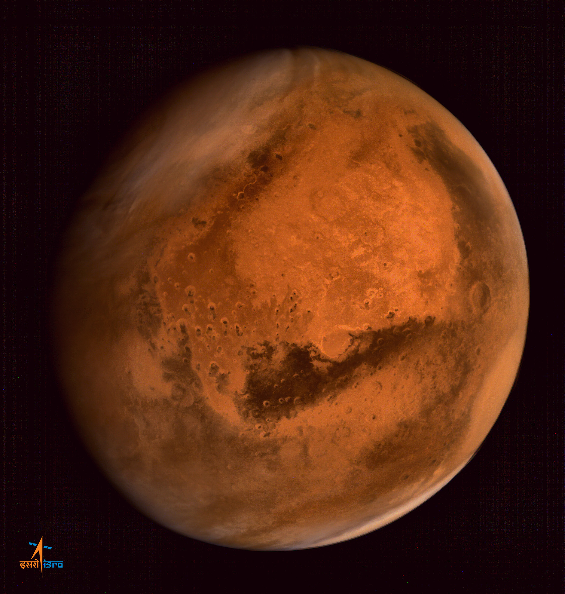
Olympus Mons, Tharsis Bulge trio of volcanoes and Valles Marineris from ISRO's Mars Orbiter Mission. Note the clouds and south polar ice cap. Credit: ISRO
MOM celebrates 1 Year at Mars
Olympus Mons, Tharsis Bulge trio of volcanoes and Valles Marineris from ISRO’s Mars Orbiter Mission. Note the clouds and south polar ice cap. Credit: ISRO[/caption]
The Mars Orbiter Mission, or MOM, is India’s first deep space voyager to explore beyond the confines of her home planets influence and successfully arrived at the Red Planet after the “history creating” orbital insertion maneuver on Sept. 23/24, 2014 following a ten month interplanetary journey from Earth.
The MOM orbiter was designed and developed by the Indian Space Research Organization (ISRO), India’s space agency, which is the equivalent of NASA.
“Mars Orbiter spacecraft marks one year of its life around the Red Planet today [Sept. 24, IST],” said ISRO. It was primarily designed as a technology demonstrator but is also outfitted with significant science instruments.
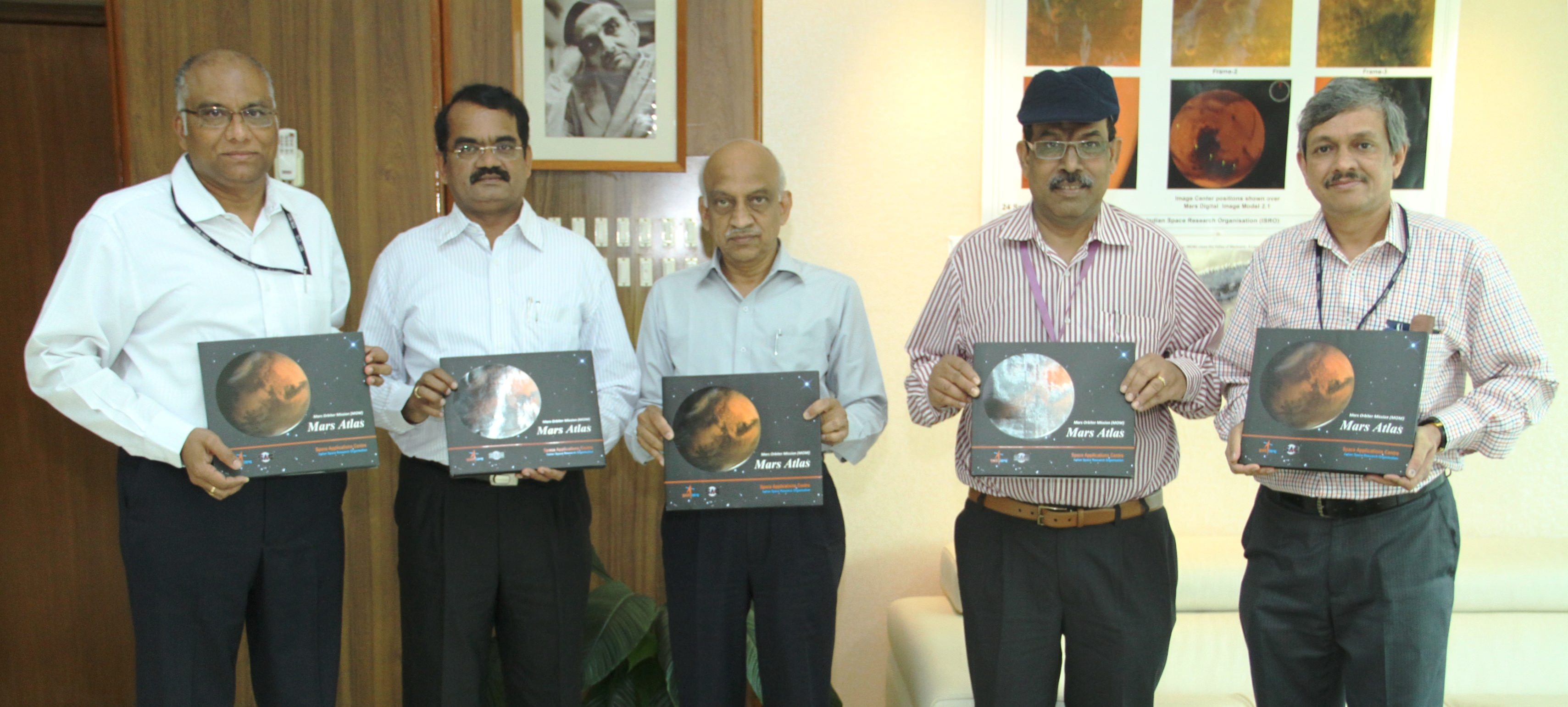
Shri A S Kiran Kumar, Chairman ISRO (centre) releasing the Mars Orbiter Mission (MOM) Mars Atlas with Dr. Y V N Krishnamoorthy, Scientific Secretary ISRO (left); Dr. Annadurai M, Director ISRO Satellite Centre, Shri Tapan Misra, Director Space Application Centre ISRO, Shri Deviprasad Karnik, Director Public Relations Unit ISRO. Credit: ISRO
The probe is equipped with a 15 kg (33 lb) suite of five indigenous instruments to conduct meaningful science – including the tri color Mars Color Camera imager (MCC) and a methane gas sniffer (MSM) to study the Red Planet’s atmosphere, morphology, mineralogy and surface features. Methane on Earth originates from both geological and biological sources – and could be a potential marker for the existence of Martian microbes.
“After successfully completing one year of the mission life around Mars, now a large data set has been acquired by all five payloads of MOM,” ISRO stated.
To mark the one year anniversary ISRO released a new 120 page “Mars Atlas” of imagery and results, which can be downloaded from the ISRO website.
“The images from MCC have provided unique information about Mars at varying spatial resolutions. It has obtained Mars Global data showing clouds, dust in atmosphere and surface albedo variations, when acquired from apoapsis at around 72000 km.”
“On the other hand high resolution images acquired from periapsis show details of various morphological features on the surface of Mars. Some of these images have been showcased in this atlas. The images have been categorized depending upon the Martian surface and atmospheric processes.”
This view over the Ophir Chasma canyon on the Martian surface was taken by the Mars Colour Camera aboard India’s Mars Orbiter Mission (MOM). Ophir Chasma is a canyon in the Coprates quadrangle located at 4° south latitude and 72.5° west longitude. It is part of the Valles Marineris canyon system. Credit: ISRO
MOM was built in record time and for a budget of $73 million.
“The MOM spacecraft was designed, built and launched in record period of less than two years,” ISRO explained. “MOM carried five science instruments collecting data on surface geology, morphology, atmospheric processes, surface temperature and atmospheric escape process.”
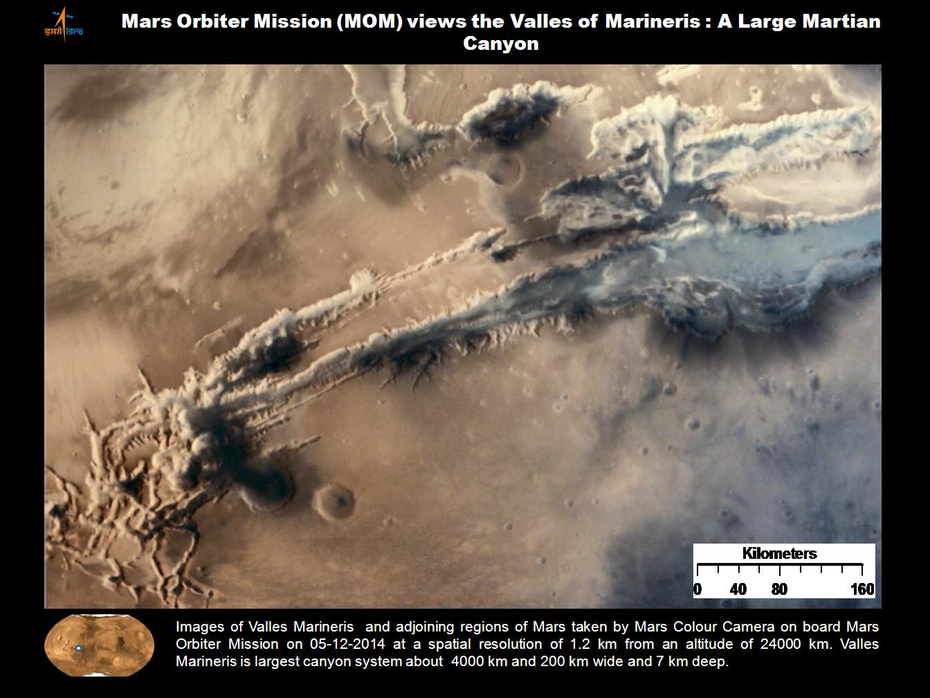
Valles Marineris from India’s Mars Mission. Credit: ISRO
MOM’s Martian arrival was webcast worldwide with an elaborate ceremony that included India’s prime minister who beamed with pride in the team and the nation at that time.
“India has successfully reached Mars!” declared Indian prime minister Narendra Modi, who watched the events unfold from mission control at ISRO’s Telemetry, Tracking and Command Network (ISTRAC) in Bangalore, on Sept. 24, 2014.
“History has been created today. We have dared to reach out into the unknown and have achieved the near-impossible. I congratulate all ISRO scientists as well as all my fellow Indians on this historic occasion.”
MOM swoops around the Red Planet in a highly elliptical orbit whose nearest point to Mars (periapsis) is about 421.7 km and farthest point (apoapsis) is about 76,993.6 km, according to ISRO
ISRO’s Mars Orbiter Mission captures spectacular portrait of the Red Planet and swirling dust storms with the on-board Mars Color Camera from an altitude of 74500 km on Sept. 28, 2014. Credit: ISRO
Upon MOM’s arrival, India became the newest member of an elite club of only four entities who have launched probes that successfully investigated Mars – following the Soviet Union, the United States and the European Space Agency (ESA).
MOM was launched on Nov. 5, 2013 from India’s spaceport at the Satish Dhawan Space Centre, Sriharikota, atop the nations indigenous four stage Polar Satellite Launch Vehicle (PSLV) which placed the probe into its initial Earth parking orbit.
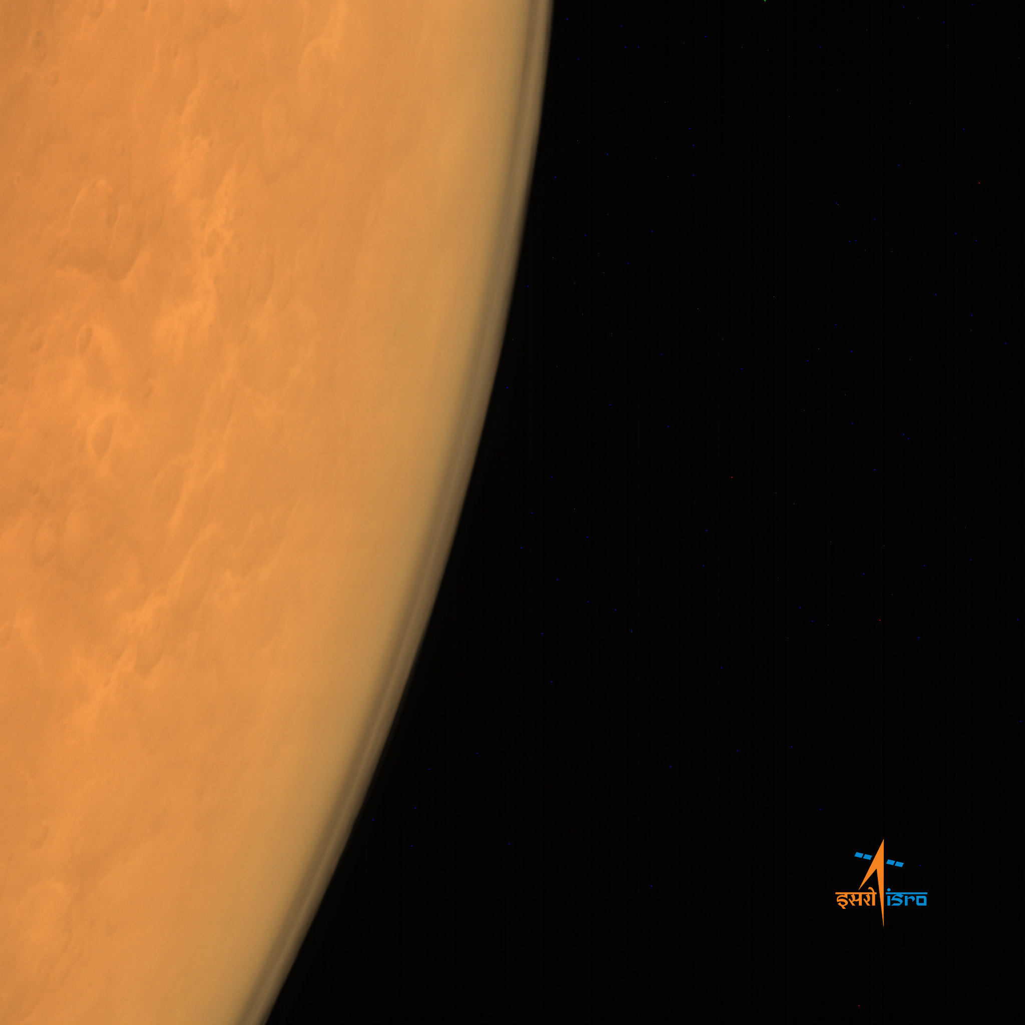
ISRO’s Mars Orbiter Mission captures the limb of Mars with the Mars Color Camera from an altitude of 8449 km soon after achieving orbit on Sept. 23/24, 2014. . Credit: ISRO
The Indian probe arrived just two days after NASA’s MAVEN Mars orbiter, the first mission specifically targeted to study Mars tenuous upper atmosphere and the escape rates of atmospheric constituents.
The $73 million MOM mission was initially expected to last at least six months. In March 2015, ISRO extended the mission duration for another six months since its healthy, the five science instruments were operating fine and it had sufficient fuel reserves.
Indeed MOM has enough fuel to continue gather data and images for years to come if the instruments and spacecraft continue to function nominally.
“The Mars Orbiter Mission still has some 45 kg of fuel left which could, in theory, keep the mission going for at least 15 years,” ISRO told The Hindu.
“One cannot get a better bang for the buck! According to ISRO, for normal housekeeping operations and orbit maintenance only about two kg of fuel is necessary per year.”
Including MOM, Earth’s invasion fleet at the Red Planet numbers a total of seven spacecraft comprising five orbiters from NASA, ESA and ISRO as well as the sister pair of mobile surface rovers from NASA – Curiosity and Opportunity.
Spectacular 3D view of Arsia Mons, a huge volcano on Mars, taken by camera on India’s Mars Orbiter Mission (MOM). Credit: ISRO
Stay tuned here for Ken’s continuing Earth and planetary science and human spaceflight news.
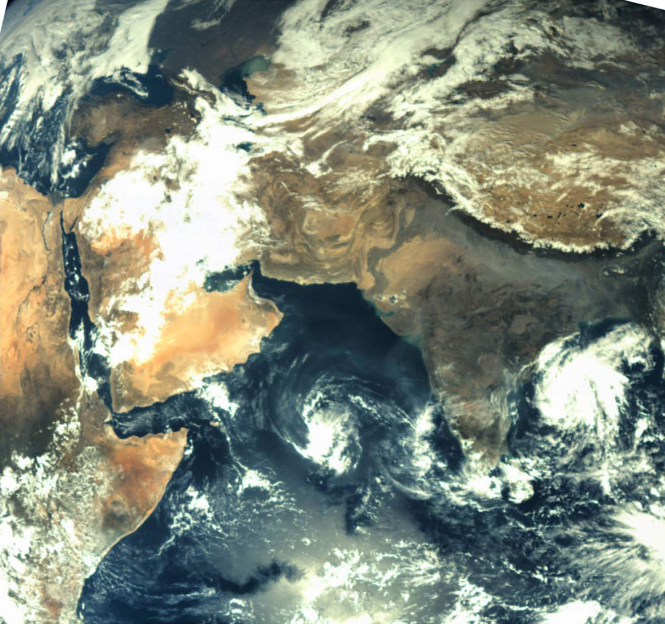
First ever image of Earth Taken by Mars Color Camera aboard India’s Mars Orbiter Mission (MOM) spacecraft while orbiting Earth and before the Trans Mars Insertion firing on Dec. 1, 2013. Image is focused on the Indian subcontinent. Credit: ISRO
This view over the Ophir Chasma canyon on the Martian surface was taken by the Mars Colour Camera aboard India’s Mars Orbiter Mission (MOM). Ophir Chasma is a canyon in the Coprates quadrangle located at 4° south latitude and 72.5° west longitude. It is part of the Valles Marineris canyon system. Credit: ISRO
India’s space agency has released a spectacular new batch of images taken by everyone’s favorite MOM – the Mars Orbiter Mission – the nation’s first probe ever dispatched to the Red Planet and which achieved orbit nearly a year ago.
The lead image was taken over the Ophir Chasma canyon on the Martian surface by the Mars Colour Camera aboard India’s Mars Orbiter Mission.
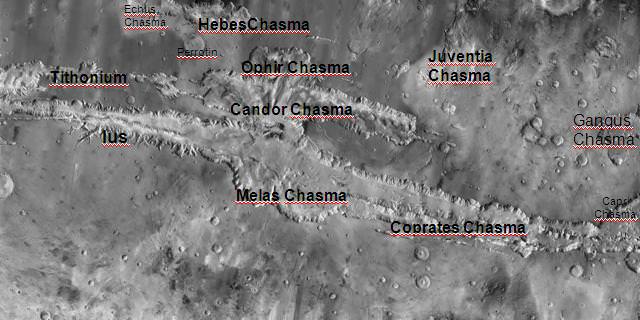
Ophir Chasma is a canyon in the Coprates quadrangle located at 4° south latitude and 72.5° west longitude. It is part of the Valles Marineris – the ‘Grand Canyon of Mars’ – and the largest known canyon in the Solar System.
The image was captured on July 19, 2015 from an altitude of 1857 kilometers (1154 miles). It has with a resolution of 96 meters.
The steep walled Ophir Chasma canyon contains many layers and the floors contain large deposits of layered materials, perhaps even sulfates.
Ophir Chasma is about 317 kilometers long and about 8 to 10 kilometers deep located near the center of Valles Marineris – see map below.
Valles Marineris stretches over 4,000 km (2,500 mi) across the Red Planet, is as much as 600 km wide and measures as much as 10 kilometers (6 mi) deep. It is nearly as wide as the United States.
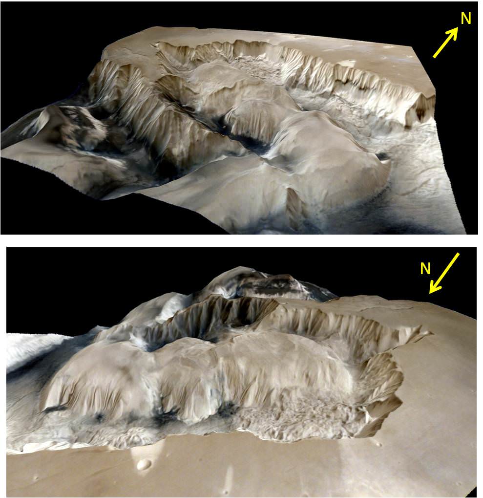
Here’s an illuminating and magnificent 3D portrayal of Ophir Chasma created by Indian scientists that gives a sense of the canyons scale, sheer walls and cliffs and depth:
3D portrayals of Ophir Chasma terrain based on images taken by India’s Mars Orbiter Mission color camera on 19 July 2015 . Credit: ISRO
The newest images were snapped after the spacecraft exited the communications blackout encountered by all of Earth’s invasion fleet of Red Planet orbiters and rovers during the recent conjunction period when Mars was behind the sun during much of June.
See the prior image release from ISRO in my MOM story – here.
Here’s a wider view of Valles Marineris showing Ophir Chasma in a previously published MOM image from ISRO.
Valles Marineris from India’s Mars Mission. Credit: ISRO
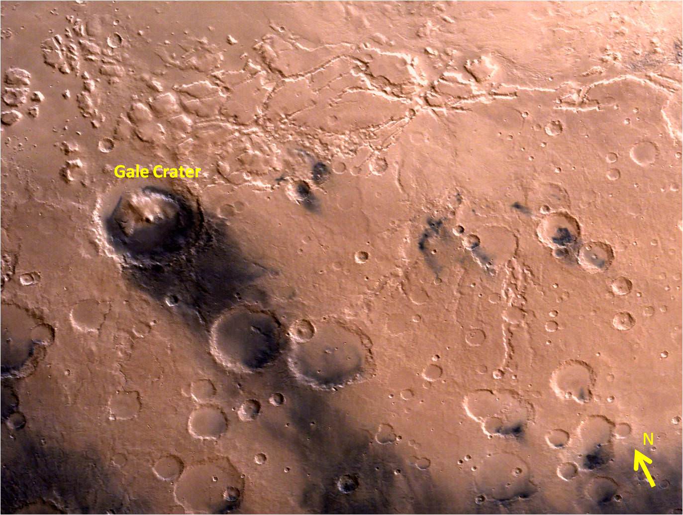
ISRO also released a delightful new image of Gale Crater and the surrounding vicinity.
Gale Crater – landing site of NASA’s Curiosity rover – and vicinity as seen by India’s Mars Orbiter Mission from an altitude of 9004 km. Gale crater is home to humongous Mount Sharp which rises 5.5 km from the crater floor and is easily visible in this photo. Credit: ISRO
Gale Crater is home to humongous Mount Sharp, a mountain that rises 5.5 kilometers (3.4 miles) from the crater floor and is easily visible in the photo from MOM. The crater is 154 kilometers (96 mi) wide.
Curiosity is currently exploring the foothills of Mount Sharp around the top of the image – which shows a rather different perspective from what we’ve seen from prior familiar orbital imagery snapped by several NASA and ESA orbiters.
The 1 ton rover recently celebrated the 3rd anniversary since its nailbiting touchdown inside Gale crater. And the new wider angle image from MOM gives a fabulous sense of exactly why a highly precise landing was essential – otherwise it would have been doomed.
Curiosity recently drilled into the “Buckskin” target at an outcrop at the foothills of Mount Sharp. See the mountain in our ground level mosaic from the crater floor. And its kind of neat to actually imagine Curiosity sitting there while perusing MOM’s photo.
Curiosity extends robotic arm and conducts sample drilling at “Buckskin” rock target at bright toned “Lion” outcrop at the base of Mount Sharp on Mars, seen at right. Gale Crater eroded rim seen in the distant background at left, in this composite multisol mosaic of navcam raw images taken to Sol 1059, July 30, 2015. Navcam camera raw images stitched and colorized. Inset: MAHLI color camera up close image of full depth drill hole at “Buckskin” rock target on Sol 1060. Credit: NASA/JPL-Caltech/MSSS/Ken Kremer/kenkremer.com/Marco Di Lorenzo
MOM’s goal is to study Mars atmosphere, surface environments, morphology, and mineralogy with a 15 kg (33 lb) suite of five indigenously built science instruments. It is also sniffing for methane, a potential marker for biological activity.
MOM is India’s first deep space voyager to explore beyond the confines of her home planets influence and successfully arrived at the Red Planet after the “history creating” orbital insertion maneuver on Sept. 23/24, 2014 following a ten month journey from Earth.
The Indian probe arrived just after NASA’s MAVEN Mars orbiter, the first mission specifically targeted to study Mars tenuous upper atmosphere and the escape rates of atmospheric constituents.
MOM swoops around Mars in a highly elliptical orbit whose nearest point to the planet (periapsis) is at about 421 km and farthest point (apoapsis) at about 76,000 km, according to ISRO.
It takes MOM about 3.2 Earth days or 72 hours to orbit the Red Planet.
MOM was launched on Nov. 5, 2013 from India’s spaceport at the Satish Dhawan Space Centre, Sriharikota, atop the nations indigenous four stage Polar Satellite Launch Vehicle (PSLV) which placed the probe into its initial Earth parking orbit.
The $73 million MOM mission was expected to last at least six months. In March, ISRO extended the mission duration for another six months since its healthy, the five science instruments are operating fine and it has sufficient fuel reserves.
Including MOM, Earth’s invasion fleet at the Red Planet numbers a total of seven spacecraft comprising five orbiters from NASA, ESA and ISRO as well as the sister pair of mobile surface rovers from NASA – Curiosity and Opportunity.
Stay tuned here for Ken’s continuing Earth and planetary science and human spaceflight news.
Location of Ophir Chasma canyon inside this annotated map of Valles Marineris created from the THEMIS camera on NASA’s Mars Odyssey orbiter. Credit: NASA
Olympus Mons, Tharsis Bulge trio of volcanoes and Valles Marineris from ISRO’s Mars Orbiter Mission. Note the clouds and south polar ice cap. Credit: ISRO
Spectacular 3D view of Arsia Mons, a huge volcano on Mars, taken by camera on India's Mars Orbiter Mission (MOM). Credit: ISRO
Spectacular 3D view of Arsia Mons, a huge volcano on Mars, taken by camera on India’s Mars Orbiter Mission (MOM). Credit: ISRO
Story updated with more details and imagery[/caption]
The Indian Space Research Organization (ISRO), India’s space agency, has recently published a beautiful gallery of images featuring a variety of picturesque Martian canyons, volcanoes, craters, moons and more.
We’ve gathered a collection here of MOM’s newest imagery snapped by the probes Mars Color Camera (MCC) for the enjoyment of Martian fans worldwide.
The spectacular 3D view of the Arsia Mons volcano, shown above, was “created by draping the MCC image on topography of the region derived from the Mars Orbiter Laser Altimeter (MOLA), one of five instruments on board NASA’s Mars Global Surveyor (MGS) spacecraft.
The Arsia Mons image was taken from Mars orbit on 1 April 2015 at a spatial resolution of 556 meters from an altitude of 10707 km. Volcanic deposits can be seen located at the flanks of the Mons, according to ISRO.
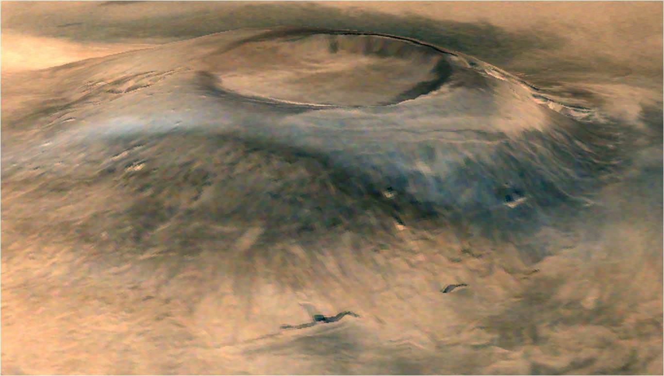
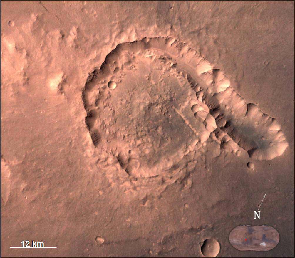
The view of Pital crater below was released in late May and taken on 23 April 2015. Pital is a 40 km wide impact crater located in the Ophir Planum region of Mars and the image shows a chain of small impact craters. It is located in the eastern part of Valles Marineris region, says an ISRO description. MCC took the image from an altitude of 808 km.
Pital crater is an impact crater located in Ophir Planum region of Mars, which is located in the eastern part of Valles Marineris region. This image is taken by Mars Color Camera (MCC) on 23-04-2015 at a spatial resolution of ~42 m from an altitude of 808 km. Credit: ISRO
It is an odd shaped crater, neither circular nor elliptical in shape, possibly due to “regional fracture in the W-E trending fracture zone.”
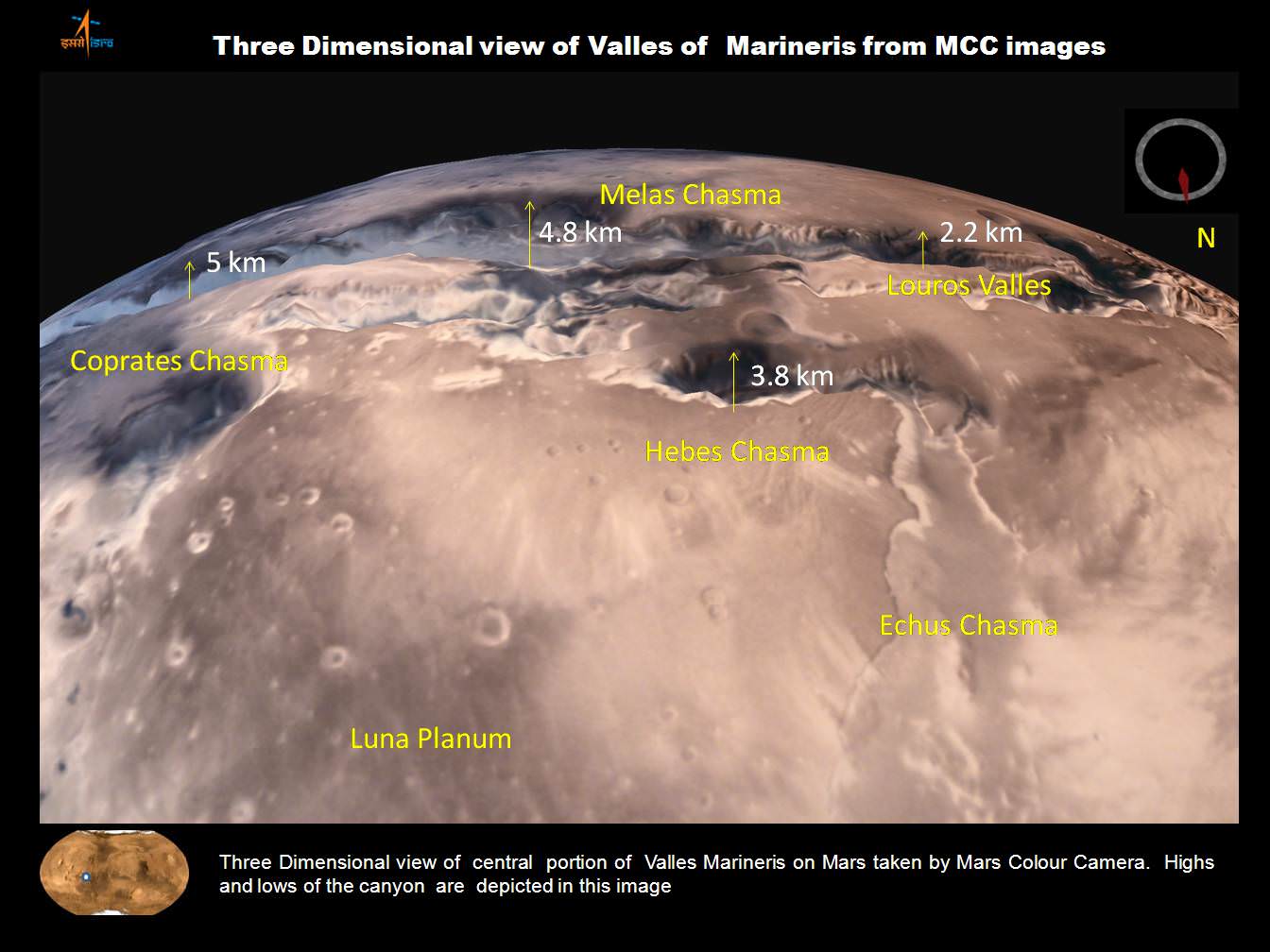
A trio of images, including one in stunning 3D, shows various portions of Valles Marineris, the largest known canyon in the Solar System.
Three dimensional view of Valles Marineris center portion from India’s MOM Mars Mission. Credit: ISRO
Valles Marineris stretches over 4,000 km (2,500 mi) across the Red Planet , is as much as 600 km wide and measures as much as 7 kilometers (4 mi) deep.
Valles Marineris from India’s Mars Mission. Credit: ISRO
For context here’s a previously taken global image of the red planet from MOM showing Valles Marinaris and Arsia Mons, which belongs to the Tharsis Bulge trio of shield volcanoes. They are both near the Martian equator.
Olympus Mons, Tharsis Bulge trio of volcanoes and Valles Marineris from ISRO’s Mars Orbiter Mission. Note the clouds and south polar ice cap. Credit: ISRO
Valles Marineris is often called the “Grand Canyon of Mars.” It spans about as wide as the entire United States.
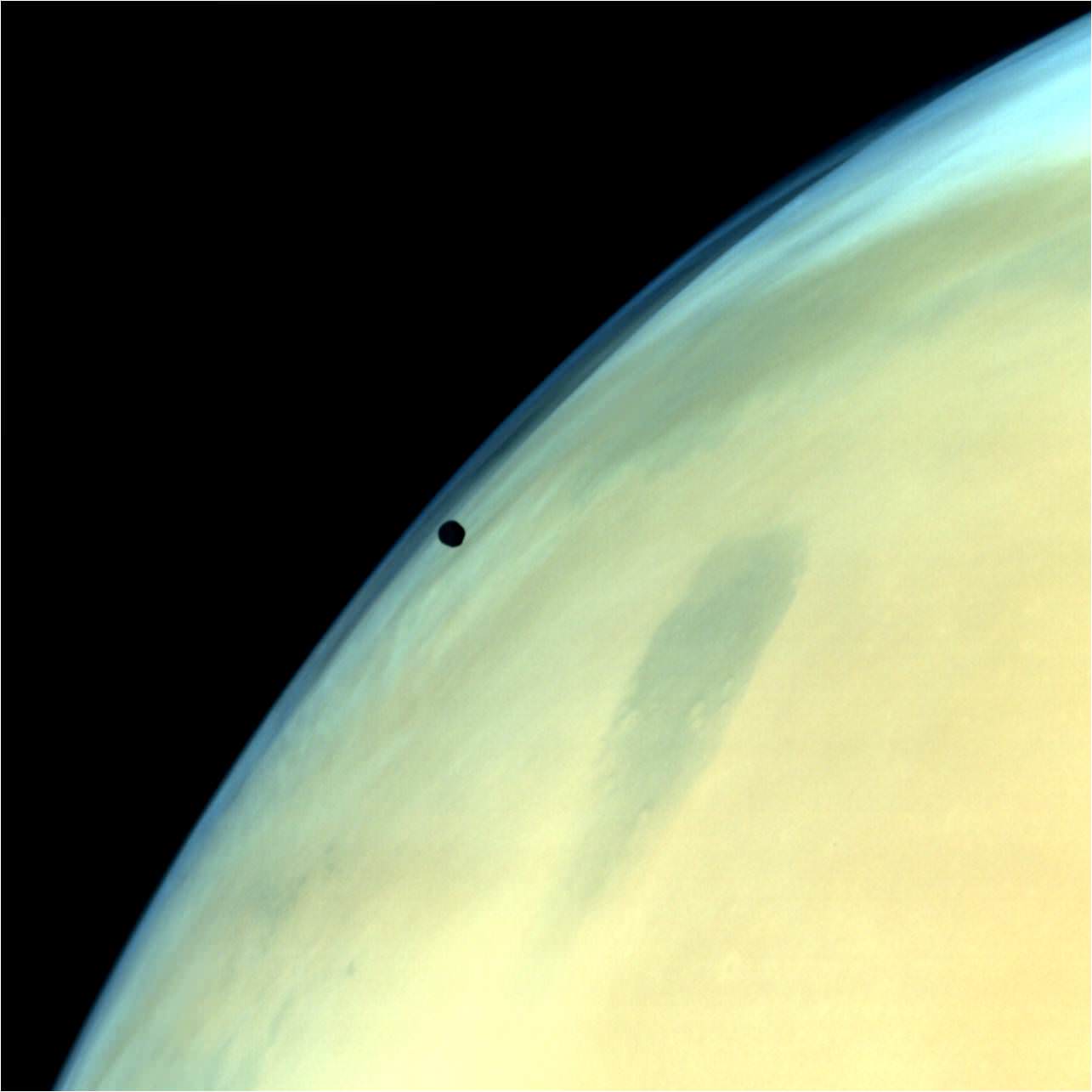
A gorgeous view of Phobos, the largest of Mars’ two tiny moons, silhouetted against the surface is shown below.
Phobos, one of the two natural satellites of Mars silhouetted against the Martian surface. Credit: ISRO
MOM’s goal is to study Mars atmosphere, surface environments, morphology, and mineralogy with a 15 kg (33 lb) suite of five indigenously built science instruments. It is also sniffing for methane, a potential marker for biological activity.
MOM is India’s first deep space voyager to explore beyond the confines of her home planets influence and successfully arrived at the Red Planet after the “history creating” orbital insertion maneuver on Sept. 23/24, 2014 following a ten month journey from Earth. MOM swoops around Mars in a highly elliptical orbit whose nearest point to the planet (periapsis) is at about 421 km and farthest point (apoapsis) at about 76,000 km, according to ISRO.
It takes MOM about 3.2 Earth days or 72 hours to orbit the Red Planet.
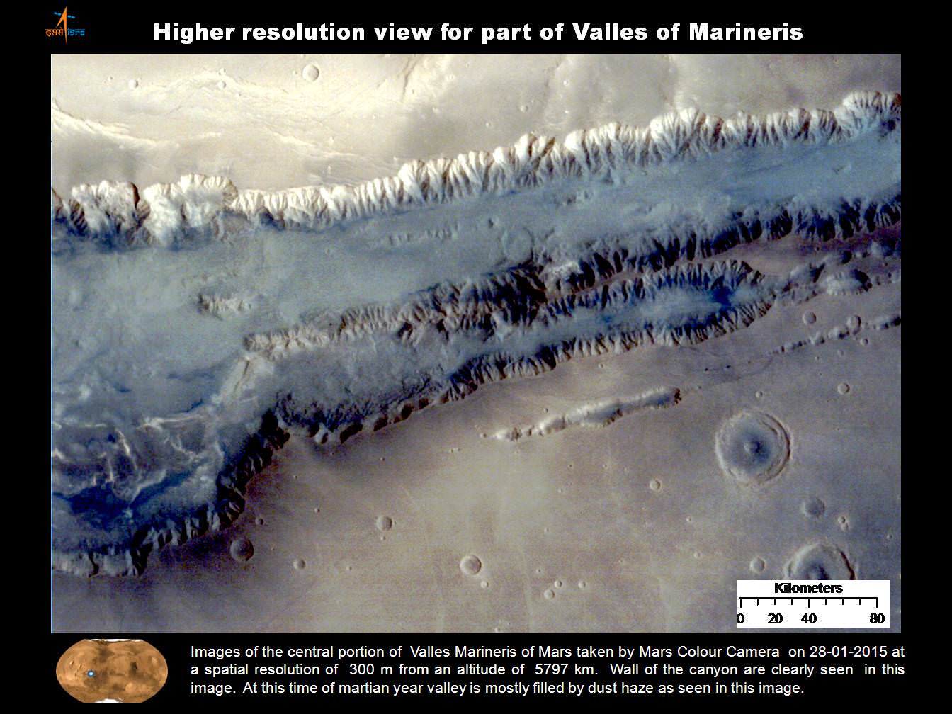
Higher resolution view of a portion of Valles Marineris canyon from India’s MOM Mars Mission. Credit: ISRO
MOM was launched on Nov. 5, 2013 from India’s spaceport at the Satish Dhawan Space Centre, Sriharikota, atop the nations indigenous four stage Polar Satellite Launch Vehicle (PSLV) which placed the probe into its initial Earth parking orbit.
The $73 million MOM mission was expected to last at least six months. In March, ISRO extended the mission duration for another six months since its healthy, the five science instruments are operating fine and it has sufficient fuel reserves.
And with a communications blackout between Mars and Earth imminent as a result of natures solar conjunction, it’s the perfect time to catch up on all things Martian.
Solar conjunctions occur periodically between Mars and Earth about every 26 months, when the two planets line up basically in a straight line geometry with the sun in between as the two planets travel in their sun-centered orbits.
Since Mars will be located behind the Sun for most of June, communications with all the Terran spacecraft at the planet is diminished to nonexistent.
“MOM faces a communication outage during June 8-25,” according to The Hindu.
Normal science operations resume thereafter.
“Fuel on the spacecraft is not an issue,” ISRO Satellite Centre Director M. Annadurai told The Hindu.
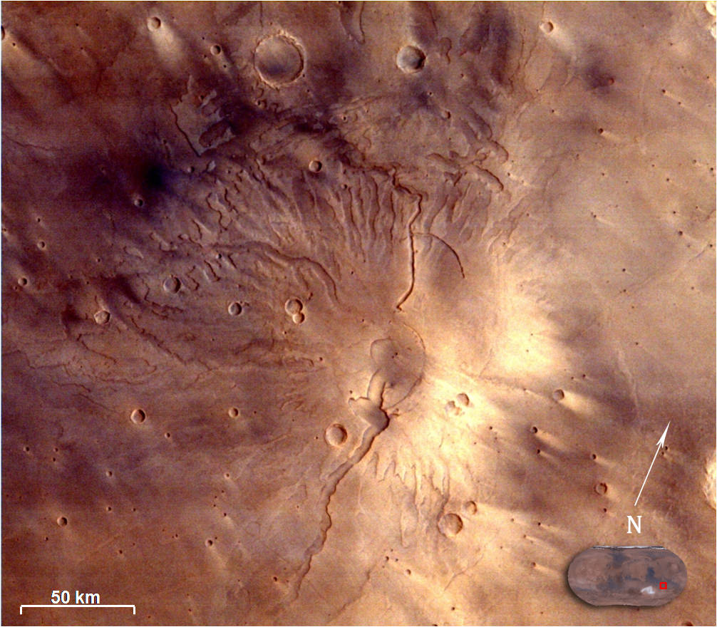
Image of Tyrrhenus Mons in Hesperia Planum region taken by Mars Color Camera (MCC) on 25-02-2015 at a spatial resolution of 166m from an altitude of 3192km. Tyrrhenus Mons is an ancient martian volcano and image shows its timeworn gullies and wind streaks. Credit: ISRO
Including MOM, Earth’s invasion fleet at the Red Planet numbers a total of seven spacecraft comprising five orbiters from NASA, ESA and ISRO as well as the sister pair of mobile surface rovers from NASA – Curiosity and Opportunity.
Stay tuned here for Ken’s continuing Earth and planetary science and human spaceflight news.