Host: Fraser Cain (@fcain)
Guests:
Morgan Rehnberg (cosmicchatter.org / @cosmic_chatter)
Ramin Skibba (@raminskibba)
Alessondra Springmann (@sondy)
Continue reading “Weekly Space Hangout – Dec. 19, 2014: Methane on Mars!”

Space and astronomy news
Host: Fraser Cain (@fcain)
Guests:
Morgan Rehnberg (cosmicchatter.org / @cosmic_chatter)
Ramin Skibba (@raminskibba)
Alessondra Springmann (@sondy)
Continue reading “Weekly Space Hangout – Dec. 19, 2014: Methane on Mars!”
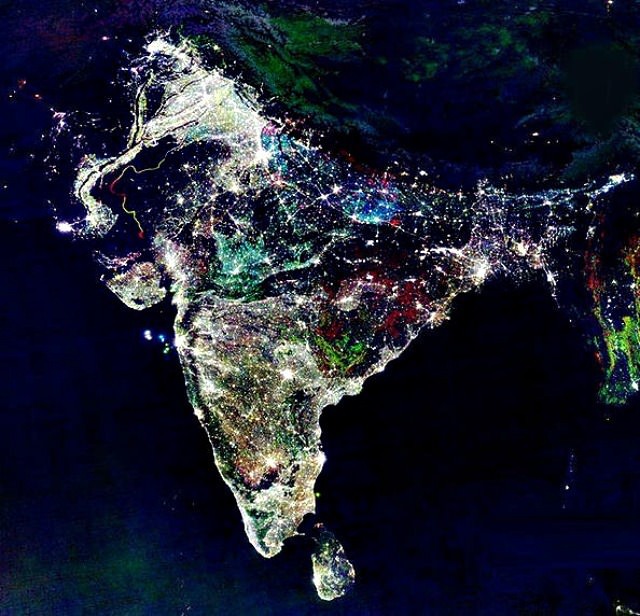
Diwali, the Indian festival of lights, falls on Thursday, Oct. 23 this year and with it come celebrations, gift-giving, and brilliant lighting and firework displays all across the subcontinent of India… but this isn’t a picture of that. What is it exactly? Find out below…
Over the past several years this image has repeatedly resurfaced online, especially around the time of Diwali. And understandably so: it’s a beautiful view of India seemingly decorated for the festival… one can easily imagine the entire country awash in colorful lights from shore to shore.
But it’s not a photo at all, or even a singular image. Rather it’s a composite of many images acquired from a USAF Defense Meteorological Satellite Program (DMSP) satellite over the course of several years, and assembled by NOAA scientist Chris Elvidge to show the country’s growing population and urban areas.
In a 2012 article by Robert Johnson on Business Insider a NASA spokesperson described the colors in the image: “The white lights were the only illumination visible before 1992. The blue lights appeared in 1992. The green lights in 1998. And the red lights appeared in 2003.”
So what does India look like at night during the five-day-long Diwali festival? Click here and see.
While city lighting in India is definitely visible from space, it’s not the rainbow explosion of neon colors that Internet hoaxers and uninformed online enthusiasts would eagerly have you believe. According to Adam Voiland on the NASA Earth Observatory site, “in reality, any extra light produced during Diwali is so subtle that it is likely imperceptible when observed from space.”
So this year, don’t fall for any false descriptions of this picture… and, Happy Diwali!
Sources: Business Insider, Mashable, NASA Earth Observatory, EarthSky. Read more about the 2014 celebration of Diwali here.
HT to Peter Caltner on Twitter for re-alerting me of this.
Last Monday, May 13, the Suomi NPP satellite captured a fascinating image of Tropical Cyclone Mahasen as it moved northeast over the Bay of Bengal. The clouds of the storm itself weren’t optically visible in the darkness of a nearly new Moon, but lightning flashes within it were… as well as the eerie ripples of atmospheric gravity waves spreading outwards from its center.
According to the Space Physics Research Group at the University of California, Berkeley:
Gravity waves are the oscillations of air parcels by the lifting force of bouyancy and the restoring force of gravity. These waves propagate vertically as well as horizontally, and actively transport energy and momentum from the troposphere to the middle and upper atmosphere. Gravity waves are caused by a variety of sources, including the passage of wind across terrestrial landforms, interaction at the velocity shear of the polar jet stream and radiation incident from space. They are found to affect atmospheric tides in the middle atmosphere and terrestrial weather in the lower atmosphere. (Source)
Atmospheric gravity waves aren’t to be confused with gravitational waves in space, which are created by very dense, massive objects (like white dwarf stars or black holes) orbiting each other closely.
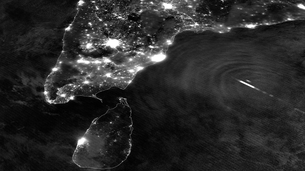
When the image was captured, Tropical Cyclone Mahasen was moving north through the Indian Ocean along a track that placed landfall along the Bangladesh coast. As it moved off the coast of India Suomi’s VIIRS Day-Night Band was able to resolve lightning flashes towards the center of the storm, along with mesopheric gravity waves emanating outwards like ripples in a pond.
Such gravity waves are of particular interest to air traffic controllers so assist in identifying areas of turbulence.
Since the moon was in a new phase, the lights and other surface features of India and Sri Lanka are clearly visible although the clouds of Mahasen are not — a tradeoff that occurs as the amount of moonlight cycles throughout the month.
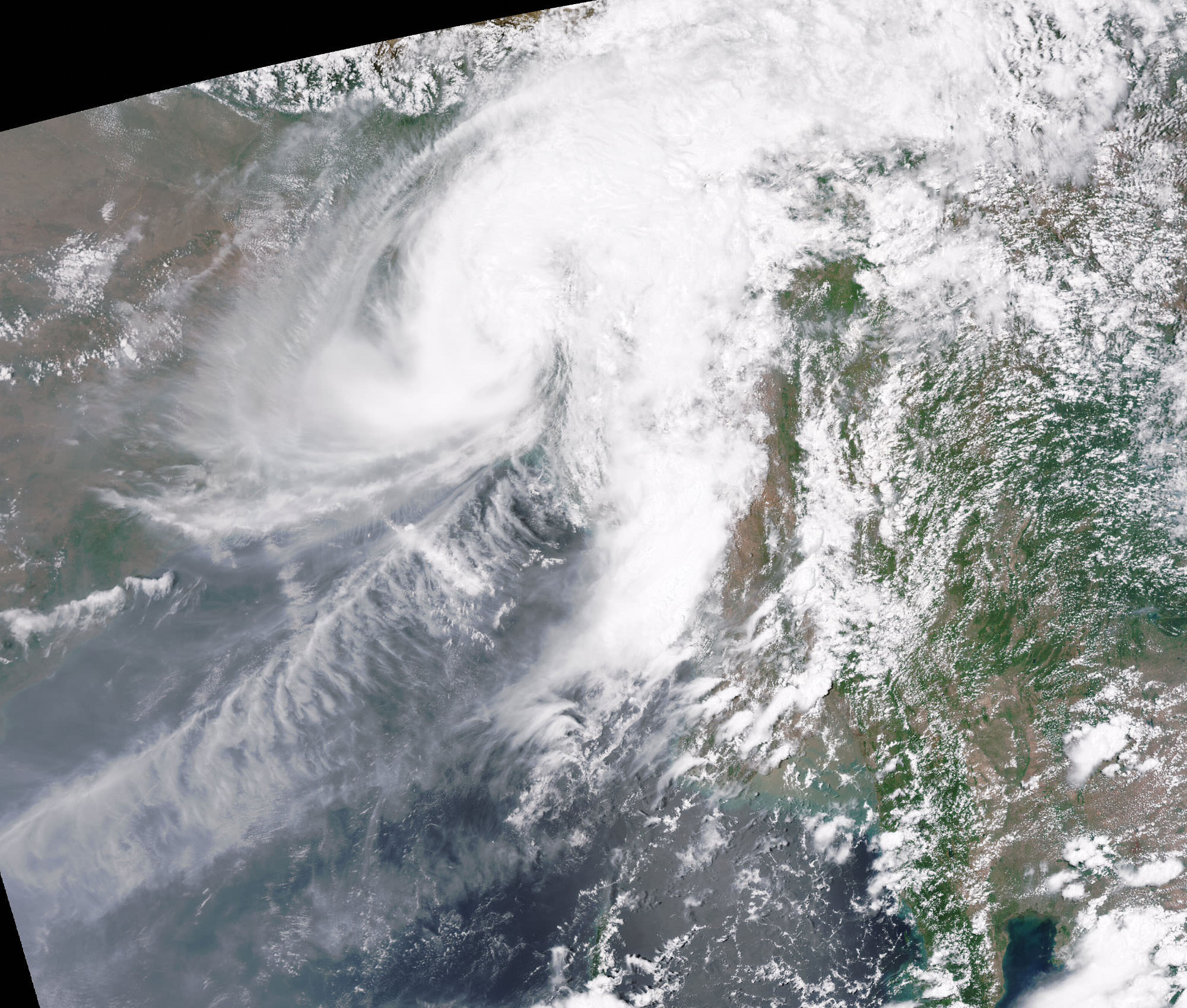
Over the course of the next few days Mahasen weakened into a deep depression, making landfall as a tropical storm on Bangladesh on May 16. In preparation for the storm large-scale evacuations were recommended for parts of Myanmar; however, this resulted in the overcrowding of boats and several vessels capsized. (Source: eosnap.com)
NASA launched the National Polar-orbiting Operational Environmental Satellite System Preparatory Project (or NPP) on October 28, 2011 from Vandenberg Air Force Base. On Jan. 24, NPP was renamed Suomi National Polar-orbiting Partnership, or Suomi NPP, in honor of the late Verner E. Suomi. It’s the first satellite specifically designed to collect data to improve short-term weather forecasts and increase understanding of long-term climate change.
Suomi NPP orbits Earth about 14 times a day, observing nearly the entire surface of the planet.
Main image source: NASA Goddard Space Flight Center

[/caption]
Unlike most satellite images of Earth, this one was not assembled from multiple swath scans or digitally projected onto a globe model — it’s the full disk of our planet in captured as a single, enormous 121 megapixel image, acquired by Russia’s Elektro-L weather-forecasting satellite.
Like NASA’s GOES satellites, Elektro-L is parked in a geostationary orbit approximately 36,000 km (22,300 miles) above our planet. Unlike NASA’s satellites, however, Elektro-L captures images in near-infrared as well as visible wavelengths, providing detail about not only cloud movement but also vegetation variations. Its wide-angle Multichannel Scanning Unit (MSU) takes images every 15-30 minutes, showing the same viewpoint of Earth across progressive times of the day.
At a resolution of 0.62 miles per pixel, full-size Elektro-L images are some of the most detailed images of Earth acquired by a weather satellite.
Download the full-size image here (100+ megabytes).

Launched aboard a Zenit rocket on January 20, 2011, Elektro-L was the first major spacecraft to be developed in post-Soviet Russia. Parked over Earth at 76 degrees east longitude, Elektro-L provides local and global weather forecasting and analysis of ocean conditions, as well as “space weather” monitoring — measurements of solar radiation and how it interacts with Earth’s magnetic field. Its initial lifespan is projected to be ten years.
A second Elektro-L satellite is anticipated to launch in 2013.
Image credit: Russian Federal Space Agency / Research Center for Earth Operative Monitoring (NTS OMZ). See more images and video from Elektro-L on James Drake’s Planet Earth here. (Tip of the geostationary hat to Jesus Diaz at Gizmodo.)

[/caption]
A team of researchers at India’s Physical Research Laboratory (PRL) claims it has found evidence of relatively recent volcanic activity on the Moon, using data from NASA’s Lunar Reconnaissance Orbiter and the Chadrayaan-1 spacecraft. According to the findings the central peak of Tycho crater contains features that are volcanic in origin, indicating that the Moon was geologically active during the crater’s formation 110 million years ago.
In an article by the Deccan Herald, a Bangalore-based publication, the PRL researchers claim that vents, lava channels and solidified flows of inner crustal material found within Tycho were made as recently as 100 million years ago — after the creation of the crater.
This could indicate that there was pre-existing volcanic activity within the Moon at the site of the Tycho impact, lending credence to the idea that the Moon was recently geologically active.
In addition, large boulders ranging in size from 33 meters to hundreds of yards across have been spotted on Tycho’s central peaks by LRO, including one 400-foot (120-meter) -wide specimen nestled atop the highest summit. How did such large boulders get there and what are they made of?

The researchers hint that they may also be volcanic in origin.
“A surprise findings revealed the presence of large boulders–about 100 meter in size –on top of the peak. Nobody knew how did they reach the top,” said Prakash Chauhan, a PRL scientist.
Without further studies it’s difficult to determine the exact origin and ages of these lunar formations. The team awaits future research by Chandrayaan-II, which will examine the Moon from orbit as well as land a rover onto the lunar surface. Chandrayaan-II is expected to launch in early 2014.
The PRL team’s findings were published in the April 10 issue of Current Science.
Read the article in the Deccan Herald here.
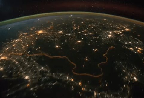
The cities of the Middle East and southern Asia shine bright in the night beneath the International Space Station as it passed high overhead on October 21, 2011.
This video, an animation made from dozens of still images taken by the Expedition 29 crew, was assembled by the Image Science and Analysis Laboratory at Johnson Space Center in Houston. It was uploaded to the Gateway to Astronaut Photography of Earth site on October 27.
[/caption]
Some glare from the Moon (off screen to the upper left) can be seen in the Plexiglas of the ISS window. The strobe-like flashes are lightning in clouds. Airglow is also visible as a band of hazy green light surrounding the planet.
Another particularly noticeable feature visible in this video is the bright orange line of the border between India and Pakistan. Erected by the Indian government to prevent smuggling, nearly 1200 miles (1930 km) of floodlights and fences separate the two countries, creating a geopolitical feature easily visible from orbit.
The website’s description states:
The sequence of shots was taken October 21, 2011 from 19:53:26 to 20:25:24 GMT, on a pass beginning over Turkmenistan, east of the Caspian Sea to southeastern China, just northwest of Hong Kong. City lights show at the beginning of the video as the ISS travels southeastward towards the India-Pakistan borderline (click here for the Earth Observatory article to learn more about this area). Pakistan’s second largest city, Lahore, can be easily seen as the brightly lit area left of track. Immediately downtrack of Lahore is New Delhi, India’s capital city, with the Kathiawar Peninsula right of track dimly lit. Smaller cities in southern India can be seen as the pass continues southeastward through southern India, into the Bay of Bengal. Lightning storms are also present, represented by the flashing lights throughout the video. The pass ends over western Indonesia, looking left of track at the island of Sumatra.
I particularly like the way the stars shine so prominently beyond Earth’s limb, and how the moonlight illuminates the clouds… not to mention the bloom of dawn at the end. What an incredible sight this must be for the ISS crew members! I can’t imagine ever getting tired of seeing this outside the Station windows.
Watch more ISS videos here.
Video courtesy of the Image Science & Analysis Laboratory, NASA Johnson Space Center.