Rosetta’s Comet Sparkles with Ice, Blows Dust From Sinkholes

Example of a cluster of bright spots on Comet 67P/Churyumov-Gerasimenko found in the Khepry region. The bright patches are thought to be exposures of water-ice. Credit: ESA/Rosetta/MPS for OSIRIS Team MPS/UPD/LAM/IAA/SSO/INTA/UPM/DASP/IDA

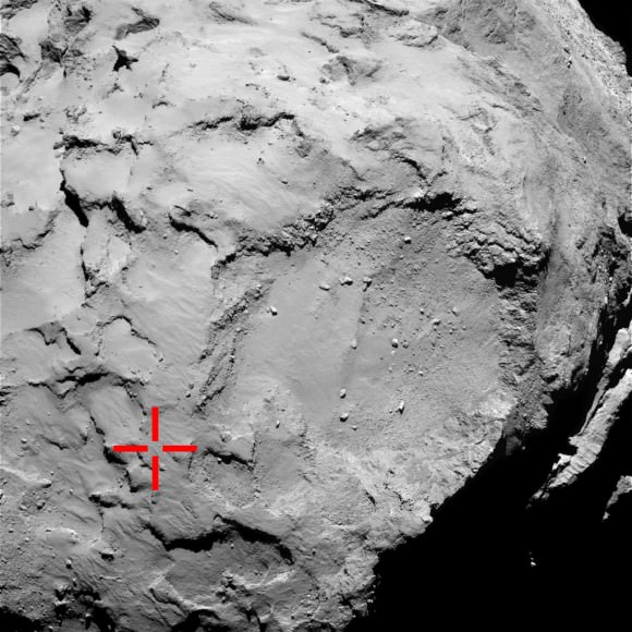
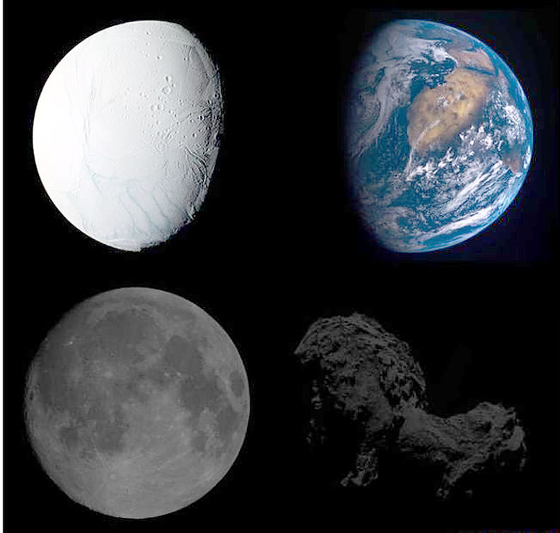
Comet 67P/C-G may be tiny at just 2.5 miles (4 km) across, but its diverse landscapes and the processes that shape them astound. To say nature packs a lot into small packages is an understatement.

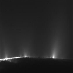
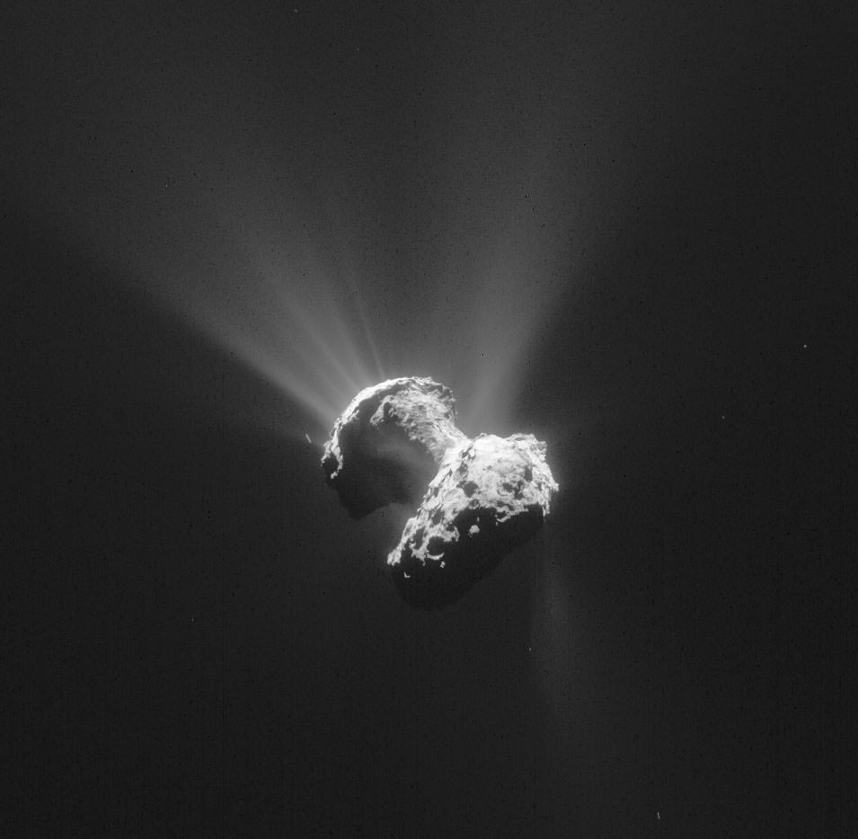
In newly-released images taken by Rosetta’s high-resolution OSIRIS science camera, the comet almost seems alive. Sunlight glints off icy boulders and pancaking sinkholes blast geysers of dust into the surrounding coma.

Examples of six different bright patches identified on the surface of Comet 67P/Churyumov-Gerasimenko in OSIRIS narrow-angle camera images acquired in September 2014. The insets point to the broad regions in which they were discovered (not to specific locations). In total, 120 bright regions, including clusters of bright features, isolated features and individual boulders, were identified in images acquired during September 2014 when the spacecraft was between 20-50 km from the comet center. The false colour images are red-green-blue composites assembled from monochrome images taken at different times and have been stretched and slightly saturated to emphasis the contrasts of colour such that dark terrains appear redder and bright regions appear significantly bluer compared with what the human eye would normally see. Credit: SA/Rosetta/MPS for OSIRIS Team MPS/UPD/LAM/IAA/SSO/INTA/UPM/DASP/IDA
Examples of six different bright patches identified on the surface of 67P/C-G in images taken last September when Rosetta was 20-50 km from the comet. The center panel points to the broad regions in which they were discovered (not specific locations). 120 bright regions, including clusters of bright features, isolated features and individual boulders, were seen. The false color images were taken at different times and have been stretched and slightly saturated to emphasis color contrasts so that dark terrains appear redder and bright regions appear significantly bluer compared with what the human eye would normally see. Credit: SA/Rosetta/MPS for OSIRIS Team MPS/UPD/LAM/IAA/SSO/INTA/UPM/DASP/IDA

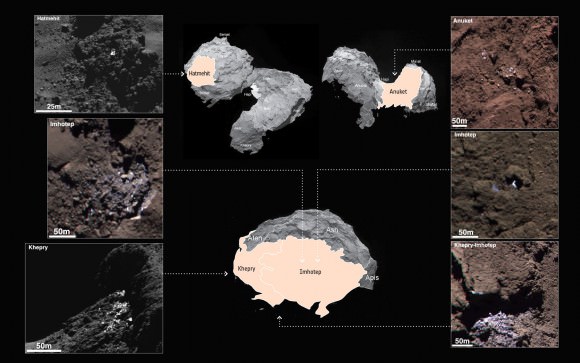
More than a hundred patches of water ice some 6 to 15 feet across (a few meters) dot the comet’s surface according to a  new study just published in the journal Astronomy & Astrophysics. We’ve known from previous studies and measurements that comets are rich in ice. As they’re warmed by the Sun, ice vaporizes and carries away embedded dust particles that form the comet’s atmosphere or coma and give it a fuzzy appearance.

Examples of icy bright patches seen on Comet 67P/Churyumov-Gerasimenko during September 2014. The two left hand images are subsets of OSIRIS narrow-angle camera images acquired on 5 September; the right hand images were acquired on 16 September. During this time the spacecraft was about 30-40 km from the comet center. Credit: ESA/Rosetta/MPS for OSIRIS Team MPS/UPD/LAM/IAA/SSO/INTA/UPM/DASP/IDA
Examples of icy bright patches and clusters seen in September 2014. The two left hand images are crops of OSIRIS narrow-angle camera images acquired on September 5; the right hand images are from September 16. During this time the spacecraft was about 19-25 miles (30-40 km) from the comet center. Credit: ESA/Rosetta/MPS for OSIRIS Team MPS/UPD/LAM/IAA/SSO/INTA/UPM/DASP/IDA

Not all that fine powder leaves the comet. Some settles back to the surface, covering the ice and blackening the nucleus. This explains why all the comets we’ve seen up close are blacker than coal despite being made of material that’s as bright as snow.

True brightness comparisons of four different Solar System bodies. At top are Saturn's moon Enceladus, its ice-covered surface making it one of the brightest objects in the Solar System, and Earth. At bottom are the Moon and Comet 67P. Credit: ESA
True brightness comparisons of four different Solar System bodies. At top are Saturn’s moon Enceladus and Earth. At bottom are the Moon and Comet 67P. Enceladus’ ice-covered surface makes it one of the brightest objects in the Solar System. In contrast, 67P is one of the darkest, its icy surface coated in dark mineral dust and organic compounds. Credit: ESA

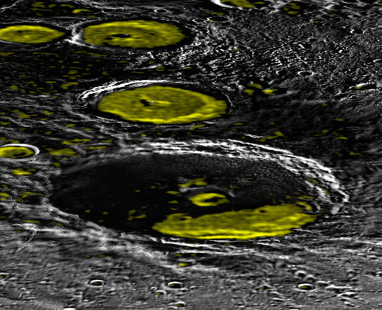
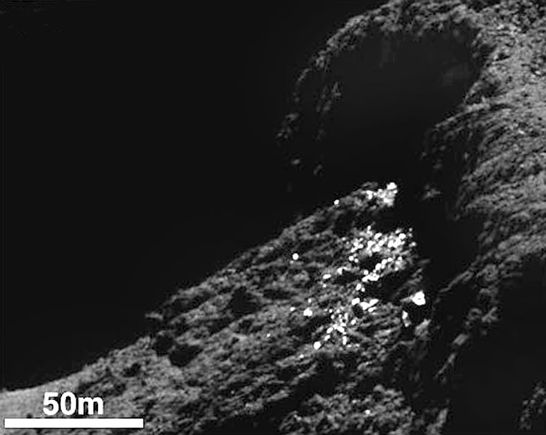
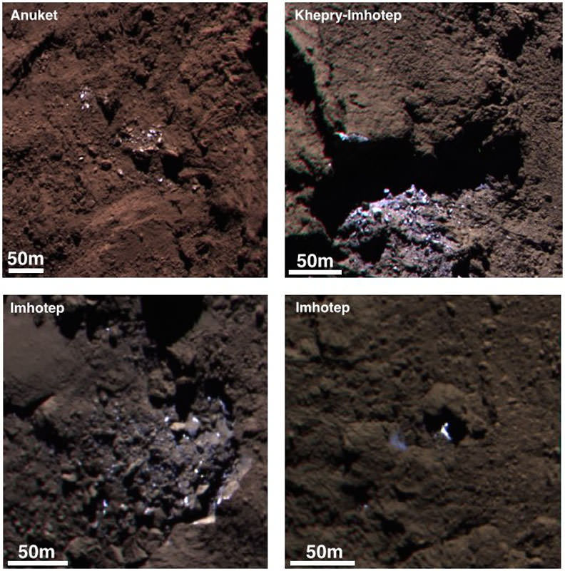
Scientists have identified 120 regions on the surface of Comet 67P/Churyumov-Gerasimenko that are up to ten times brighter than the average surface brightness. Some are individual boulders, while others form clusters of bright specks. Seen in high resolution, many appear to be boulders with exposures of ice on their surfaces; the clusters are often found at the base of overhanging cliffs and likely got there when cliff walls collapsed, sending an avalanche of icy rocks downhill and exposing fresh ice not covered by dark dust.

An individual boulder about 12 feet across with bright patches on its surface in the Hatmehit region. Credit: ESA/Rosetta/MPS for OSIRIS Team MPS/UPD/LAM/IAA/SSO/INTA/UPM/DASP/IDA

More intriguing are the isolated boulders found here and there that appear to have no relation to the surrounding terrain.  Scientists think they arrived George Jetson style when they were jetted from the comet’s surface by the explosive vaporization of ice only to later land in a new location. The comet’s exceedingly low gravity makes this possible. Let that image marinate in your mind for a moment.

All the ice-glinting boulders seen thus far were found in shadowed regions not exposed to sunlight, and no changes were observed in their appearance over a month’s worth of observations.

“Water ice is the most plausible explanation for the occurrence and properties of these features,” says Antoine Pommerol of the University of Bern and lead author of the study.

How do we know it’s water ice and not CO2 or some other form of ice? Easy. When the observations were made, water ice would have been vaporizing at the rate of 1 mm per hour of solar illumination. By contrast, carbon monoxide or carbon dioxide ice, which have much lower freezing points, would have rapidly sublimated in sunlight. Water ice vaporizes much more slowly in comparison.

Lab tests using ice mixed with different minerals under simulated sunlight revealed that it only took a few hours of sublimation to produce a dust layer only a few millimeters thick. But it was enough to conceal any sign of ice. They also found that small chunks of dust would sometimes break away to expose fresh ice beneath.

“A 1 mm thick layer of dark dust is sufficient to hide the layers below from optical instruments,” confirms Holger Sierks, OSIRIS principal investigator at the Max Planck Institute for Solar System Research.

Comet 67P/C-G on June 21, 2015. The nucleus is a mixture of frozen ices and dust. As the comet approaches the Sun, sunlight warms its surface, causing the ices to boil away. This gas streams away carrying along large amounts of dust, and together they build up the coma. Copyright: ESA/Rosetta/NavCam – CC BY-SA IGO 3.0

It appears then that Comet 67P’s surface is mostly covered in dark dust with small exposures of fresh ice resulting from changes in the landscape like crumbling cliffs and boulder-tossing from jet activity. As the comet approaches perihelion, some of that ice will become exposed to sunlight while new patches may appear. You, me and the Rosetta team can’t wait to see the changes.

High-resolution view of active regions in Seth as seen with Rosetta’s OSIRIS narrow-angle camera on 20 September 2014 from a distance of about 26 km from the surface. The image scale is about 45 cm/pixel. The Seth_01 pit is seen close to centre and measures approximately 220 m across and 185 m deep. Credit: ESA/Rosetta/MPS for OSIRIS Team MPS/UPD/LAM/IAA/SSO/INTA/UPM/DASP/IDA
High-resolution view of an active pit photographed last September from a distance of about 16 miles  (26 km) from the comet’s surface in the Seth region. The image scale is about 45 cm a pixel. The Seth_01 pit measures approximately 720 feet (220 m) across and 605 feet (85 m) deep. Note the smooth deposits of dust around the pit. Credit: ESA/Rosetta/MPS for OSIRIS Team MPS/UPD/LAM/IAA/SSO/INTA/UPM/DASP/IDA

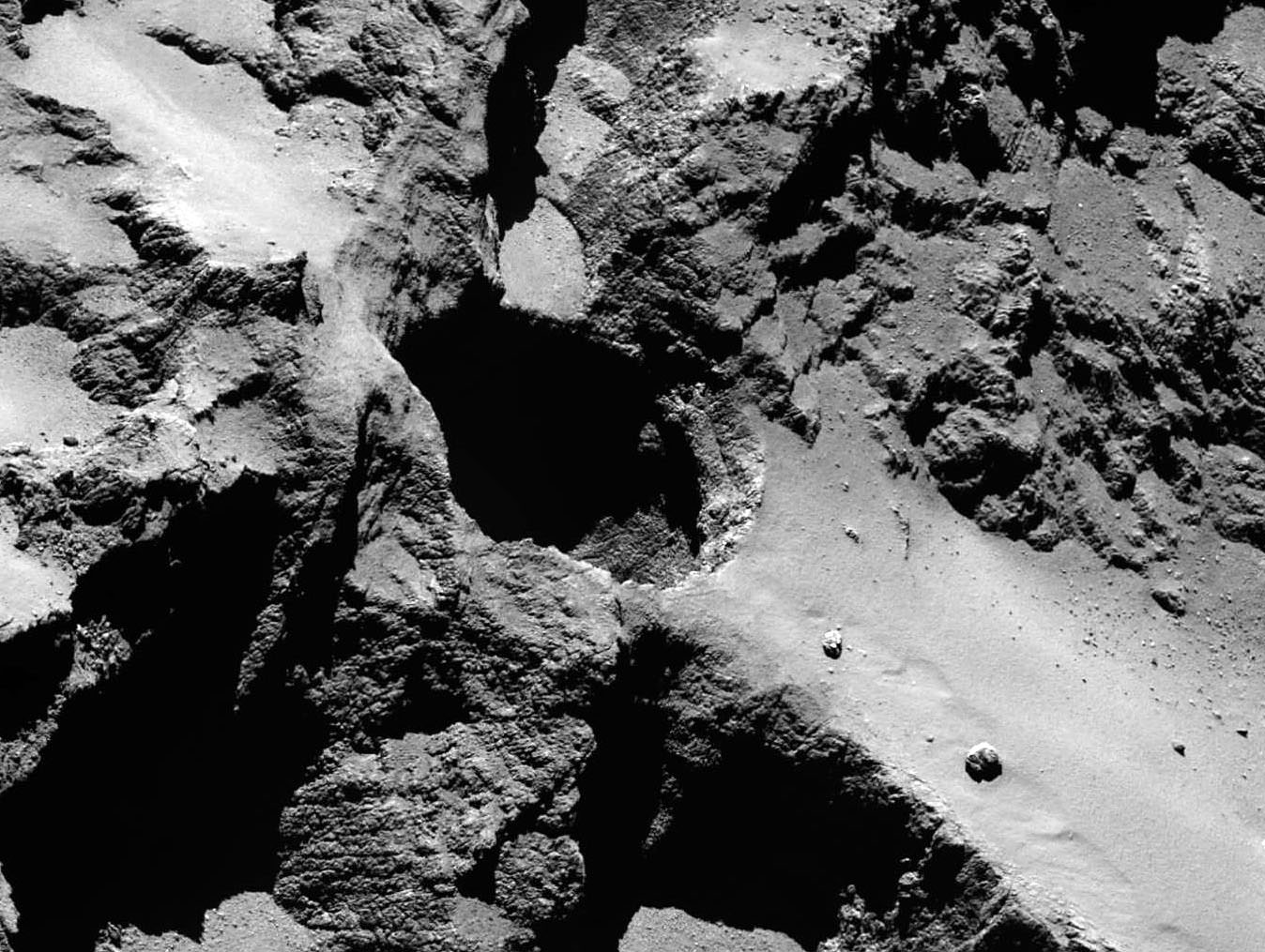
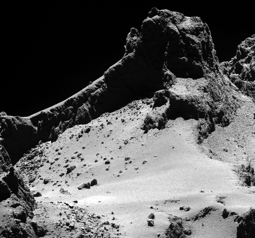
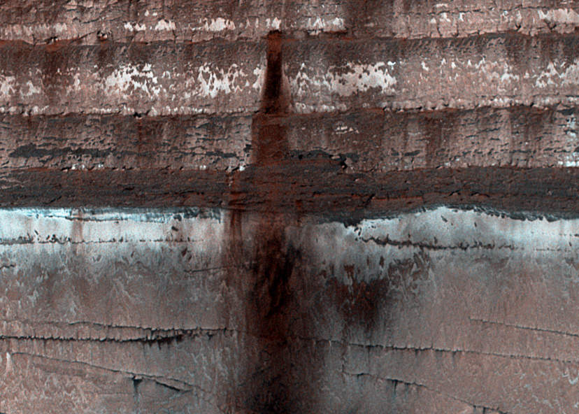
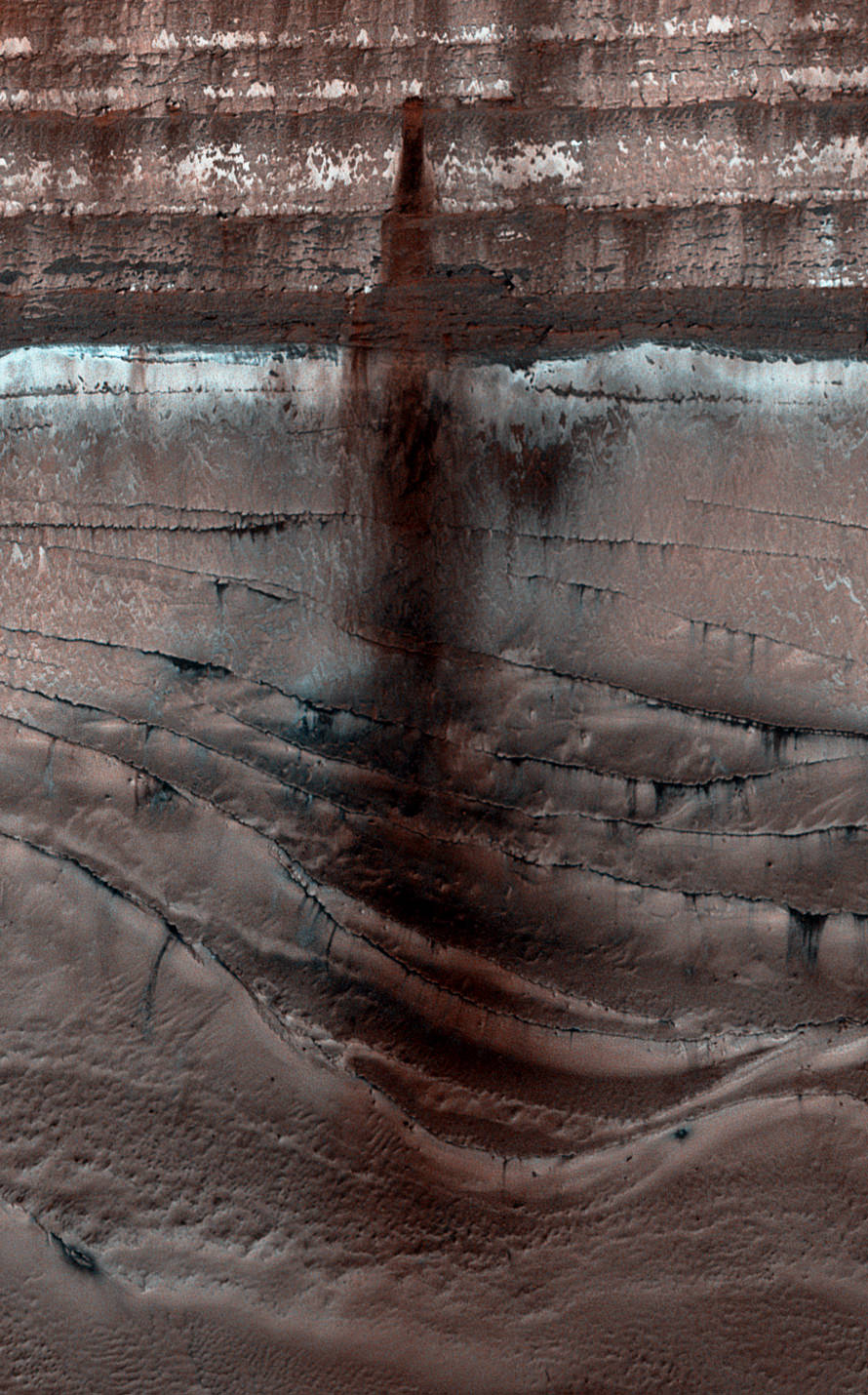
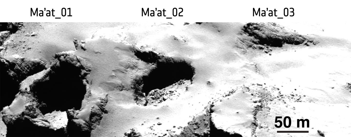
Ever wonder how a comet gets its jets? In another new study appearing in the science journal Nature, a team of researchers report that 18 active pits or sinkholes have been identified in the comet’s northern hemisphere. These roughly circular holes appear to be the source of the elegant jets like those seen in the photo above. The pits range in size from around 100 to 1,000 feet (30-100 meters) across with depths up to 690 feet (210 meters). For the first time ever, individual jets can be traced back to specific pits.

In specially processed photos, material can be seen streaming from inside pit walls like snow blasting from a snowmaking machine. Incredible!

Active pits detected in the Seth region of Comet 67P/Churyumov¬Gerasimenko can be seen in the lower right portion of this OSIRIS wide-angle camera image. The contrast of the image has been deliberately stretched to reveal the details of the fine-structured jets against the shadow of the pit, which are interpreted as dusty streams rising from the fractured wall of the pit. The image was acquired on 20 October 2014 from a distance of 7 km from the surface of the comet. Credits: ESA/Rosetta/MPS for OSIRIS Team MPS/UPD/LAM/IAA/SSO/INTA/UPM/DASP/IDA
Active pits detected in the Seth region of the comet. The contrast of the image has been stretched to reveal the details of the fine-structured jets against the shadow of the pit, which are interpreted as dusty streams rising from the fractured wall of the pit. The image was acquired on October 20, 2014 from a distance of 4.3 miles (7 km) from the surface of the comet. Credit: ESA/Rosetta/MPS for OSIRIS Team MPS/UPD/LAM/IAA/SSO/INTA/UPM/DASP/IDA

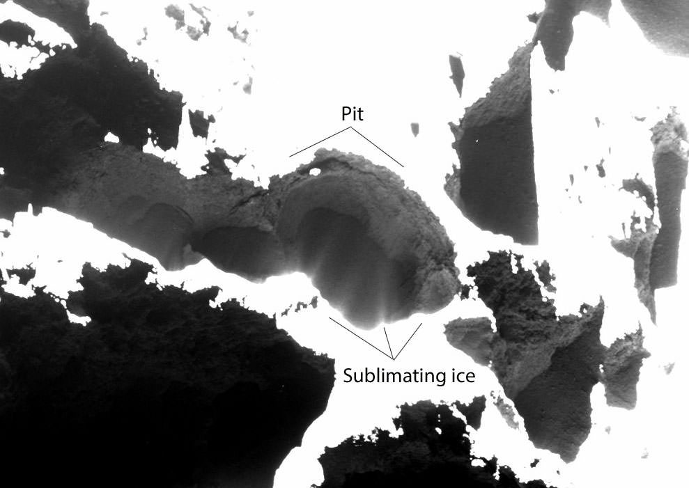
“We see jets arising from the fractured areas of the walls inside the pits. These fractures mean that volatiles trapped under the surface can be warmed more easily and subsequently escape into space,” said Jean-Baptiste Vincent from the Max Planck Institute for Solar System Research, lead author of the study.

Similar to the way sinkholes form on Earth, scientists believe pits form when the ceiling of a subsurface cavity becomes too thin to support its own weight. With nothing below to hold it place, it collapses, exposing fresh ice below which quickly vaporizes. Exiting the hole, it forms a collimated jet of dust and gas.

Pits Ma’at 1, 2 and 3 on Comet 67P/Churyumov–Gerasimenko show differences in appearance that may reflect their history of activity. While pits 1 and 2 are active, no activity has been observed from pit 3. The young, active pits are particularly steep-sided, whereas pits without any observed activity are shallower and seem to be filled with dust. Middle-aged pits tend to exhibit boulders on their floors from mass-wasting of the sides. The image was taken with the OSIRIS narrow-angle camera from a distance of 28 km from the comet surface. Credits: ESA/Rosetta/MPS for OSIRIS Team MPS/UPD/LAM/IAA/SSO/INTA/UPM/DASP/IDA
Pits Ma’at 1, 2 and 3 show differences in appearance that may reflect their history of activity. While pits 1 and 2 are active, no activity has been observed from pit 3. The young, active pits are very steep-sided; pits without any observed activity are shallower and seem to be filled with dust. Middle-aged pits tend to have boulders on their floors from mass-wasting of the sides.
Credits: ESA/Rosetta/MPS for OSIRIS Team MPS/UPD/LAM/IAA/SSO/INTA/UPM/DASP/IDA

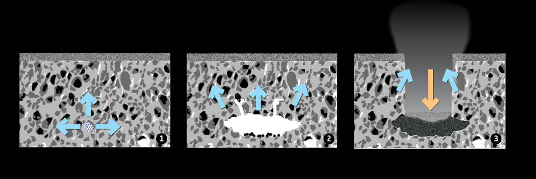
The paper’s authors suggest three ways for pits to form:

* The comet may contain voids that have been there since its formation. Collapse could be triggered by either vaporizing ice or seismic shaking when boulders ejected elsewhere on the comet land back on the surface.
* Direct sublimation of pockets of volatile (more easily vaporized) ices like carbon dioxide and carbon monoxide below the surface as sunlight warms the dark surface dust, transferring heat below.
* Energy liberated by water ice changing its physical state from amorphous to its normal crystalline form and stimulating the sublimation of the surrounding more volatile carbon dioxide and carbon monoxide ices.

Graphic explaining how Comet 67P/Churyumov–Gerasimenko’s pits may form through sinkhole collapse. The graphic shows a dusty surface layer covering a mixture of dust and ices. 1. Heat causes subsurface ices to sublimate (blue arrows), forming a cavity (2). When the ceiling becomes too weak to support its own weight, it collapses, creating a deep, circular pit (3, red arrow). Newly exposed material in the pit walls sublimates, accounting for the observed activity (3, blue arrows).
Graphic showing how pits may form through sinkhole collapse in the comet’s dusty surface layer covering a mixture of dust and ices. 1. Heat causes subsurface ices to sublimate (blue arrows), forming a cavity. 2.When the ceiling becomes too weak to support its own weight, it collapses, creating a deep, circular pit (orange arrow). Newly exposed material in the pit walls sublimates (blue arrows). Credit: ESA/Rosetta/J-B Vincent et al (2015)

The researchers think they can use the appearance of the sinkholes to age-date different parts of the comet’s surface — the more pits there are in a region, the younger and less processed the surface there is. They point to 67P/C-G’s southern hemisphere which receives more energy from the Sun than the north and at least for now, shows no pit structures.

The most active pits have steep sides, while the least show softened contours and are filled with dust. It’s even possible that a partial collapse might be the cause of the occasional outbursts when a comet suddenly brightens and enlarges as seen from Earth. Rosetta observed just such an outburst this past April. And these holes can really kick out the dust! It’s estimated a typical full pit collapse releases a billion kilograms of material.

With Rosetta in great health and perihelion yet to come, great things lie ahead. Maybe we’ll witness a new sinkhole collapse, an icy avalanche or even levitating boulders!

Sources: 1, 2

Ceres Has Lots of Bright Spots

A rayed crater on Ceres with a great deal of fresh material (ice?) exposed by impact. Credit: NASA

Those bright mystery spots aren’t the only ones on Ceres. Recent photos posted on JPL’s Photojournal site  feature a spectacular rayed crater resembling the familiar lunar craters Kepler and Copernicus.

Unique view of the lunar crater Proclus showing an extension system of bright rays taken from Apollo 15. Credit: NASA
Bright dribs and drabs of material are seen in this photo taken by Dawn on May 22, 2015 from 3,200 miles (5,100 km). Credit: NASA
Bright dots and patches of material are seen in this photo taken by Dawn on May 22, 2015 from 3,200 miles (5,100 km) away. Credit: NASA/JPL-Caltech/UCLA/MPS/DLR/IDA
Taken back on May 4 from 8,400 miles, this photo shows the rayed crater (bottom) and another bright spot. Credit:
Taken back on May 4 from 8,400 miles (13,600 km), this photo shows the rayed crater (bottom) and another bright spot above center. Credit: NASA/JPL-Caltech/UCLA/MPS/DLR/IDA

Lunar rays are bright because they contrast with their older surroundings which have been darkened by exposure to solar and cosmic radiation. Impacts expose fresh material from below the surface that settles into a spider web of rays around the newly excavated crater. Huge boulders lofted above the Moon’s surface during the impact slam back into the crust to create secondary craters also crowned with bright dust and rock.

Based on Ceres' density, it contains a large fraction of low density materials including clays, water ice, salts and organic compounds. This schematic gives a general idea of the dwarf planet's makeup. Credit: NASA/ESA/STScI
Based on Ceres’ density, it contains a large fraction of low density materials including clays, water ice, salts and organic compounds. This schematic gives a general idea of the dwarf planet’s makeup. Credit: NASA/ESA/STScI

Most models of Ceres depict a rocky crust,  mantle of ice and a rocky inner core.  This makes us wonder if the bright material unearthed might be ice. If so, it would gradually vaporize on the virtually air-free dwarf planet.

Dawn will spend through early 2016 at Ceres during its primary mission and then remain in orbit there perpetually. We should be able to cipher the composition of the white material during that time with the spacecraft’s Gamma Ray and Neutron Detector and Visible and Infrared Mapping Spectrometer, but a lengthy stay might allow us to see changes in the extent of any ice exposures as they gradually vaporize away.

Uncropped, untoned view of the rayed crater seen in the earlier image. Credit:
Uncropped, untoned view of the rayed crater seen in the earlier image. Credit: NASA/JPL-Caltech/UCLA/MPS/DLR/IDA

One thing we know for certain about Ceres are its dimensions. Dawn observations have revised the size to be about 599 miles (963 km) across at the equator with a polar diameter of 554 miles (891 km). Like Earth and other planets, Ceres is a slightly flattened sphere wider at the equator than from pole to pole. The temperature there ranges from about -100°F (-73°C) during the day and dips to -225°F (-143°C) at night. That makes its daytime high about 28° warmer than coldest temperature ever recorded on Earth.

Latest Research Reveals a Bizarre and Vibrant Rosetta’s Comet

Dust-covered, boulder-strewn landscape on the smaller of the two lobes of Comet 67P/Churyumov-Gerasimenko taken from a distance of 5 miles (8 km). Credit: ESA/Rosetta/MPS for OSIRIS Team MPS/UPD/LAM/IAA/SSO/INTA/UPM/DASP/IDA

We’ve subsisted for months on morsels of information coming from ESA’s mission to Comet 67P/Churyumov-Gerasimenko. Now, a series of scientific papers in journal Science offers a much more complete, if preliminary, look at Rosetta’s comet. And what a wonderful and complex world it is.

Scientists have defined 19 regions on Comet 67P/Churyumov-Gerasimenko's nucleus grouped according to terrain. Each is named for an ancient Egytptian deity. Credits: ESA/Rosetta/MPS/OSIRIS Team/UPD/LAM/IAA/SSO /INTA/UPM/DASP/IDA
Scientists have defined 19 regions on Comet 67P/Churyumov-Gerasimenko’s nucleus according to terrain and named for Egyptian deities like Imhotep, Aten and Hathor. Credits: ESA/Rosetta/MPS/OSIRIS Team/UPD/LAM/IAA/SSO /INTA/UPM/DASP/IDA

Each of the papers describes a different aspect of the comet from the size and density of dust particles jetting from the nucleus, organic materials found on its surface and the diverse geology of its bizarre landscapes. Surprises include finding no firm evidence yet of ice on the comet’s nucleus. There’s no question water and other ices compose much of 67P’s 10 billion ton mass, but much of it’s buried under a thick layer of dust.

Despite its solid appearance, 67P is highly porous with a density similar to wood or cork and orbited by a cloud of approximately 100,000 “grains” of material larger than 2 inches (5 cm) across stranded there after the comet’s previous perihelion passage. Thousands of tiny comet-lets!
Continue reading “Latest Research Reveals a Bizarre and Vibrant Rosetta’s Comet”

Get a Change of View of Mercury’s North Pole

A forced perspective view of Profokiev crater near Mercury's north pole

It’s always good to get a little change of perspective, and with this image we achieve just that: it’s a view of Mercury’s north pole projected as it might be seen from above a slightly more southerly latitude. Thanks to the MESSENGER spacecraft, with which this image was originally acquired, as well as the Arecibo Observatory here on Earth, scientists now know that these polar craters contain large deposits of water ice – which may seem surprising on an airless and searing-hot planet located so close to the Sun but not when you realize that the interiors of these craters never actually receive sunlight.

The locations of ice deposits are shown in the image in yellow. See below for a full-sized version.

Perspective view of Mercury's north pole made from MESSENGER MDIS data.
Perspective view of Mercury’s north pole made from MESSENGER MDIS images and Arecibo Observatory data. (NASA/Johns Hopkins University Applied Physics Laboratory/Carnegie Institution of Washington)

The five largest ice-filled craters in this view are (from front to back) the 112-km-wide Prokofiev and the smaller Kandinsky, Tolkien, Tryggvadottir, and Chesterton craters. A mosaic of many images acquired by MESSENGER’s Mercury Dual Imaging Sustem (MDIS) instrument during its time in orbit, you would never actually see a view of the planet’s pole illuminated like this in real life but orienting it this way helps put things into…well, perspective.

Radar observations from Arecibo showing bright areas on Mercury's north pole
Radar observations from Arecibo showing bright areas on Mercury’s north pole

Radar-bright regions in Mercury’s polar craters have been known about since 1992 when they were first imaged from the Arecibo Observatory in Puerto Rico. Located in areas of permanent shadow where sunlight never reaches (due to the fact that Mercury’s axial tilt is a mere 2.11º, unlike Earth’s much more pronounced 23.4º slant) they have since been confirmed by MESSENGER observations to contain frozen water and other volatile materials.

Read more: Ice Alert! Mercury’s Deposits Could Tell Us More About How Water Came To Earth

Similarly-shadowed craters on our Moon’s south pole have also been found to contain water ice, although those deposits appear different in composition, texture, and age. It’s suspected that some of Mercury’s frozen materials may have been delivered later than those found on the Moon, or are being restored via an ongoing process. Read more about these findings here.

Explore Mercury’s shadowed craters with the Water Ice Data Exploration (WIDE) app

In orbit around Mercury since 2011, MESSENGER is now nearing the end of its operational life. Engineers have figured out a way to extend its fuel use for an additional month, possibly delaying its inevitable descent until April, but even if this maneuver goes as planned the spacecraft will be meeting Mercury’s surface very soon.

Source: MESSENGER

Philae Lander Early Science Results: Ice, Organic Molecules and Half a Foot of Dust

Philae's MUPUS probe took temperature measurements and hammered into the surface at the landing site to discover the lander alighted on some very hard ice. Credit: ESA

An uncontrolled, chaotic landing.  Stuck in the shadow of a cliff without energy-giving sunlight.  Philae and team persevered.  With just 60 hours of battery power, the lander drilled, hammered and gathered science data on the surface of comet 67P/Churyumov-Gerasimenko before going into hibernation. Here’s what we know. 

Despite appearances, the comet’s hard as ice. The team responsible for the MUPUS (Multi-Purpose Sensors for Surface and Sub-Surface Science) instrument hammered a probe as hard as they could into 67P’s skin but only dug in a few millimeters:

Close-up of the first touchdown site before Philae landed (left) and after clearly shows the impressions of its three footpads in the comet’s dusty soil. Times are CST. Philae’s 3.3 feet (1-m) across. Credit: ESA
Close-up of the first touchdown site before Philae landed (left) and after clearly shows the impressions of its three footpads in the comet’s dusty soil. At the final landing site, it’s believed that Times are CST. Philae’s 3.3 feet (1-m) across. Credit: ESA

“Although the power of the hammer was gradually increased, we were not able to go deep into the surface,” said Tilman Spohn from the DLR Institute of Planetary Research, who leads the research team. “If we compare the data with laboratory measurements, we think that the probe encountered a hard surface with strength comparable to that of solid ice,” he added. This shouldn’t be surprising, since ice is the main constituent of comets, but much of 67P/C-G appears blanketed in dust, leading some to believe the surface was softer and fluffier than what Philae found.

This finding was confirmed by the SESAME experiment (Surface Electrical, Seismic and Acoustic Monitoring Experiment) where the strength of the dust-covered ice directly under the lander was “surprisingly high” according to Klaus Seidensticker from the DLR Institute. Two other SESAME instruments measured low vaporization activity and a great deal of water ice under the lander.

As far as taking the comet’s temperature, the MUPUS thermal mapper worked during the descent and on all three touchdowns. At the final site, MUPUS recorded a temperature of –243°F (–153°C) near the floor of the lander’s balcony before the instrument was deployed. The sensors cooled by a further 10°C over a period of about a half hour:

The location of Philae's first touchdown on the surface of Comet 67P/C-G. Although covered in dust in many areas, Philae found strong evidence for firm ice beneath. Credits: ESA/Rosetta/MPS for OSIRIS Team MPS/UPD/LAM/IAA/SSO/INTA/UPM/DASP/IDA
The location of Philae’s first touchdown on the surface of Comet 67P/C-G. Although covered in dust in many areas, Philae found strong evidence for firm ice beneath the comet’s surface. Credits: ESA/Rosetta/MPS for OSIRIS Team MPS/UPD/LAM/IAA/SSO/INTA/UPM/DASP/IDA

“We think this is either due to radiative transfer of heat to the cold nearby wall seen in the CIVA images or because the probe had been pushed into a cold dust pile,” says Jörg Knollenberg, instrument scientist for MUPUS at DLR. After looking at both the temperature and hammer probe data, the Philae team’s preliminary take is that the upper layers of the comet’s surface are covered in dust 4-8 inches (10-20 cm), overlaying firm ice or ice and dust mixtures.

The ROLIS camera (ROsetta Lander Imaging System) took detailed photos during the first descent to the Agilkia landing site. Later, when Philae made its final touchdown, ROLIS snapped images of the surface at close range. These photos, which have yet to be published, were taken from a different point of view than the set of panorama photos already received from the CIVA camera system.

During Philae’s active time, Rosetta used the CONSERT (COmet Nucleus Sounding Experiment by Radio wave Transmission) instrument to beam a radio signal to the lander while they were on opposite sides of the comet’s nucleus. Philae then transmitted a second signal through the comet back to Rosetta. This was to be repeated 7,500 times for each orbit of Rosetta to build up a 3D image of 67P/C-G’s interior, an otherworldly “CAT scan” as it were.  These measurements were being made even as Philae lapsed into hibernation. Deeper down the ice becomes more porous as revealed by measurements made by the orbiter.

Rosetta’s Philae lander includes a carefully selected set of instruments and is being prepared for a November 11th dispatch to analyze a comet’s surface. Credit: ESA, Composite – T.Reyes
Rosetta’s Philae lander includes a carefully selected set of instruments to analyze a comet’s surface. Credit: ESA, Composite – T.Reyes

The last of the 10 instruments on board the Philae lander to be activated was the SD2 (Sampling, Drilling and Distribution subsystem), designed to provide soil samples for the COSAC and PTOLEMY instruments. Scientists are certain the drill was activated and that all the steps to move a sample to the appropriate oven for baking were performed, but the data right now show no actual delivery according to a tweet this morning from Eric Hand, reporter at Science Magazine. COSAC worked as planned however and was able to “sniff” the comet’s rarified atmosphere to detect the first organic molecules. Research is underway to determine if the compounds are simple ones like methanol and ammonia or more complex ones like the amino acids.

Stephan Ulamec, Philae Lander manager, is confident that we’ll resume contact with Philae next spring when the Sun’s angle in the comet’s sky will have shifted to better illuminate the lander’s solar panels. The team managed to rotate the lander during the night of November 14-15, so that the largest solar panel is now aligned towards the Sun. One advantage of the shady site is that Philae isn’t as likely to overheat as 67P approaches the Sun en route to perihelion next year. Still, temperatures on the surface have to warm up before the battery can be recharged, and that won’t happen until next summer.

Let’s hang in there. This phoenix may rise from the cold dust again.

Sources: 1, 2

Hubble Discovers Water Plumes Erupting from Europa

UV observations from Hubble show the size of water vapor plumes coming from Europa's south pole (NASA, ESA, and M. Kornmesser)

It’s been known since 2005 that Saturn’s 300-mile-wide moon Enceladus has geysers spewing ice and dust out into orbit from deep troughs that rake across its south pole. Now, thanks to the Hubble Space Telescope (after 23 years still going strong) we know of another moon with similar jets: Europa, the ever-enigmatic ice-shelled moon of Jupiter. This makes two places in our Solar System where subsurface oceans could be getting sprayed directly into space — and within easy reach of any passing spacecraft.

(Psst, NASA… hint hint.)

The findings were announced today during the meeting of the American Geophysical Union in San Francisco.

“The discovery that water vapor is ejected near the south pole strengthens Europa’s position as the top candidate for potential habitability,” said lead author Lorenz Roth of the Southwest Research Institute (SwRI) in San Antonio, Texas. “However, we do not know yet if these plumes are connected to subsurface liquid water or not.”

The 125-mile (200-km) -high plumes were discovered with Hubble observations made in December 2012. Hubble’s Space Telescope Imaging Spectrograph (STIS) detected faint ultraviolet light from an aurora at the Europa’s south pole. Europa’s aurora is created as it plows through Jupiter’s intense magnetic field, which causes particles to reach such high speeds that they can split the water molecules in the plume when they hit them. The resulting oxygen and hydrogen ions revealed themselves to Hubble with their specific colors.

Unlike the jets on Enceladus, which contain ice and dust particles, only water has so far been identified in Europa’s plumes. (Source)

Rendering showing the location and size of water vapor plumes coming from Europa's south pole.
Rendering showing the location and size of water vapor plumes coming from Europa’s south pole.

The team suspects that the source of the water is Europa’s long-hypothesized subsurface ocean, which could contain even more water than is found across the entire surface of our planet.

Read more: Europa’s Hidden Great Lakes May Harbor Life

“If those plumes are connected with the subsurface water ocean we are confident exists under Europa’s crust, then this means that future investigations can directly investigate the chemical makeup of Europa’s potentially habitable environment without drilling through layers of ice,” Roth said. “And that is tremendously exciting.”

One other possible source of the water vapor could be surface ice, heated through friction.

Cassini image of ice geysers on Enceladus (NASA/JPL/SSI)

In addition the Hubble team found that the intensity of Europa’s plumes, like those of Enceladus, varies with the moon’s orbital position around Jupiter. Active jets have been seen only when Europa is farthest from Jupiter. But the researchers could not detect any sign of venting when Europa is closer.

One explanation for the variability is Europa undergoes more tidal flexing as gravitational forces push and pull on the moon, opening vents at larger distances from Jupiter. The vents get narrowed or even seal off entirely when the moon is closest to Jupiter.

Still, the observation of these plumes — as well as their varying intensity — only serves to further support the existence of Europa’s ocean.

“The apparent plume variability supports a key prediction that Europa should tidally flex by a significant amount if it has a subsurface ocean,” said Kurt Retherford, also of SwRI.

(Science buzzkill alert: although exciting, further observations will be needed to confirm these findings. “This is a 4 sigma detection, so a small uncertainly that the signal is just noise in the instruments,” noted Roth.)

“If confirmed, this new observation once again shows the power of the Hubble Space Telescope to explore and opens a new chapter in our search for potentially habitable environments in our solar system.”

– John Grunsfeld, NASA’s Associate Administrator for Science

Read more: Hydrogen Peroxide Could Feed Life on Europa

So. Who’s up for a mission to Europa now? (And unfortunately in this case, Juno doesn’t count.)

“Juno is a spinning spacecraft that will fly close to Jupiter, and won’t be studying Europa,” Kurt Retherford told Universe Today. “The team is looking hard how we can optimize, maybe looking for gases coming off Europa and look at how the plasma interacts with environment, so we really need a dedicated Europa mission.”

We couldn’t agree more.

The findings were published in the Dec. 12 online issue of Science Express.

Sources: Hubble news releases (US and ESA)

Image credits:
Graphic Credit: NASA, ESA, and L. Roth (Southwest Research Institute and University of Cologne, Germany)
Science Credit: NASA, ESA, L. Roth (Southwest Research Institute and University of Cologne, Germany), J. Saur (University of Cologne, Germany), K. Retherford (Southwest Research Institute), D. Strobel and P. Feldman (Johns Hopkins University), M. McGrath (Marshall Space Flight Center), and F. Nimmo (University of California, Santa Cruz)

A Dark and Dusty Avalanche on Mars

Loose soil, dust and rock stains an icy cliffside on Mars (NASA/JPL/University of Arizona)

Mars may be geologically inactive but that doesn’t mean there’s nothing happening there — seasonal changes on the Red Planet can have some very dramatic effects on the landscape, as this recent image from the HiRISE camera shows!

The full extent of the 1000-meter-long dusty landslide (NASA/JPL/University of Arizona)

When increasing light from the springtime Sun warms up the sides of sheer cliffs made from countless layers of water and carbon dioxide ice near Mars’ north pole, some of that CO2 ice sublimes, sending cascades of loose soil and dust down to the terraced base below. This uncovered material stains the frost-covered polar surface dark, outlining the paths of avalanches for HiRISE to easily spot from orbit. (See the original HiRISE image here.)

Circling Mars since March 2006, the HiRISE camera aboard NASA’s Mars Reconnaissance Orbiter has even captured some of these polar landslides in action.

The rust-colored avalanche shown above has fallen hundreds of meters from the middle of a layered ice deposit, spreading nearly a kilometer across the frozen ridges at the base of the cliff. The view was acquired on Sept. 13, 2013.

Check out a video explaining this view and the processes that created it below, narrated by Phil Plait (aka the Bad Astronomer).

Mars’ seasonal polar caps are composed primarily of carbon dioxide frost. This frost sublimates (changes from solid directly to gas) in the spring, boosting the pressure of Mars’ thin atmosphere. In the fall the carbon dioxide condenses, causing the polar caps to reach as far as ~55 degrees latitude by late winter. By learning about current processes on a local level we can learn more about how to interpret the geological record of climate changes on Mars. (Source)

These Antarctic Research Photos Look Like Exploration on Another Planet

Researchers work in the Antarctic polar night during a storm (Credit: Stefan Hendricks, Alfred Wegner Institute)

Some day, human explorers will land a spacecraft on the surface of Europa, Enceladus, Titan, or some other icy world and investigate first-hand the secrets hidden beneath its frozen surface. When that day comes — and it can’t come too soon for me! — it may look a lot like this.

One of a series of amazing photos by Stefan Hendricks taken during the Antarctic Winter Ecosystem & Climate Study (AWECS), a study of Antarctica’s sea ice conducted by the Alfred Wegener Institute in Germany, the image above shows researchers working on the Antarctic ice during a winter snowstorm. It’s easy to imagine them on the night-side surface of Europa, with the research vessel Polarstern standing in for a distant illuminated lander (albeit rather oversized).

Hey, one can dream!

One of the goals of the campaign, called CryoVex, was to look at how ESA’s CryoSat mission can be used to understand the thickness of sea ice in Antarctica. The extent of the Antarctic sea ice in winter is currently more than normal, which could be linked to changing atmospheric patterns.

Antarctica’s massive shelves of sea ice in winter are quite dramatic landscapes, and remind us that there are very alien places right here on our own planet.

See this and more photos from the mission on the ESA website (really, go check them out!)

NASA Scientists Soar Over a Mini Ice Cap

Saunders Island and Wolstenholme Fjord with Kap Atholl in the background photographed during a NASA IceBridge flight. (NASA/Michael Studinger)

It’s quite a long way from Mars, but I can’t help but be reminded of the Red Planet’s ice-covered north pole when looking at this photo taken by Michael Studinger earlier this month, during a recent IceBridge survey flight over Greenland.

Called Saunders Island (also Appat Island) the 82-square-mile frozen slab of rock rises from the sea off the coast of northwestern Greenland, one of many islands within the Wolstenholme (Uummannaq) Fjord on the shore of Baffin Bay. Operation IceBridge, a six-year aerial survey of the changing ice coverage at our planet’s poles, is run by NASA to provide valuable ground-level information to supplement satellite data.

To me, the shape of the island’s steep rock faces and rugged inlets slice into its interior bear a striking resemblance to Mars’ ice cap.

Mars' north polar ice cap
Mars’ north polar ice cap

While Mars’ ice cap is shaped by very different processes — and obviously much bigger — you might see the connection too!

But rather than dark Martian dunes, sea ice can be seen surrounding the islands in varying thicknesses in the IceBridge photo above. Sea ice coverage in the fjord ranges from thicker, white ice in the background to thinner “grease” ice and leads with dark, open ocean water in the foreground.

The IceBridge P-3B airborne laboratory in a hangar at Wallops Flight Facility (NASA/George Hale)

As the amount of darker, ice-free water surfaces increase over the course of the year due to rising global temperatures, the more heat from solar radiation is collected in the ocean — thus speeding up the process of seasonal sea ice loss and overall Arctic warming.

Read more about the IceBridge mission here, and see a collection of more photos from this season’s flights here.

NASA’s Operation IceBridge images Earth’s polar ice in unprecedented detail to better understand processes that connect the polar regions with the global climate system. IceBridge utilizes a highly specialized fleet of research aircraft and the most sophisticated suite of innovative science instruments ever assembled to characterize annual changes in thickness of sea ice, glaciers, and ice sheets. In addition, IceBridge collects critical data used to predict the response of earth’s polar ice to climate change and resulting sea-level rise.