Here’s the view of Hurricane Sandy from an altitude of 254 statute miles from external cameras on the International Space Station. This video was shot as the ISS flew over the US’s eastern seaboard at 12:52 Eastern time October 29, 2012. Sandy has yet to officially make landfall, but the huge storm is already battering a region that makes up the most densely populated area of the US. The combination of three different storms has caused it to be dubbed as “Frankenstorm,” but it could turn into a “Blizzicane” as a winter storm merges with Sandy. The hurricane itself is strengthening as it barrels toward a landfall along the New Jersey coastline.
Below is video of the ISS pass at 11:16 a.m on Monday:
At the time of the flyover, Sandy was located 420 km (260 miles) south-southeast of New York City, moving north-northwest at 18 miles an hour with winds measured at 90 miles an hour as a Category 1 hurricane, according to the National Hurricane Center.
The huge slow moving combination of storms stretches about 1,600 km (1,000 miles) from north to south and significant impacts of storm surge and flooding are expected, with at least 7-10 inches of rain. This comes along with a snow advisory in some regions, creating a “Blizzicane” in the mountains of West Virgina, with 2-4 feet of snow predicted.
Forecasters are predicting this to be a multi-billion dollar storm disaster.
Here are some recent images of the storm:
Satellite View of Hurricane Sandy on Oct. 29 at 9:10 EDT by NOAA’s GOES-13 satellite.
Hurricane Sandy Viewed in the Dark of Night. Image acquired by the Visible Infrared Imaging Radiometer Suite (VIIRS) on the Suomi NPP satellite around 2:42 a.m. Eastern Daylight Time (06:42 Universal Time) on October 28, 2012.
Hurricane Sandy made landfall on Cuba early Thursday Oct. 25, 2012 as strong Category 2. Credit: NOAA/National Hurricane Center
Meteorologists keeping an eye on Hurricane Sandy say the storm threatens to move up along the east coast of the United States and could mix with a wintery storm coming from the west to form a monster storm that has been informally dubbed “Frankenstorm.” The hurricane could reach the US coast by this weekend and when the two storms collide, it could continue to pound the eastern seaboard well into the week of Halloween.
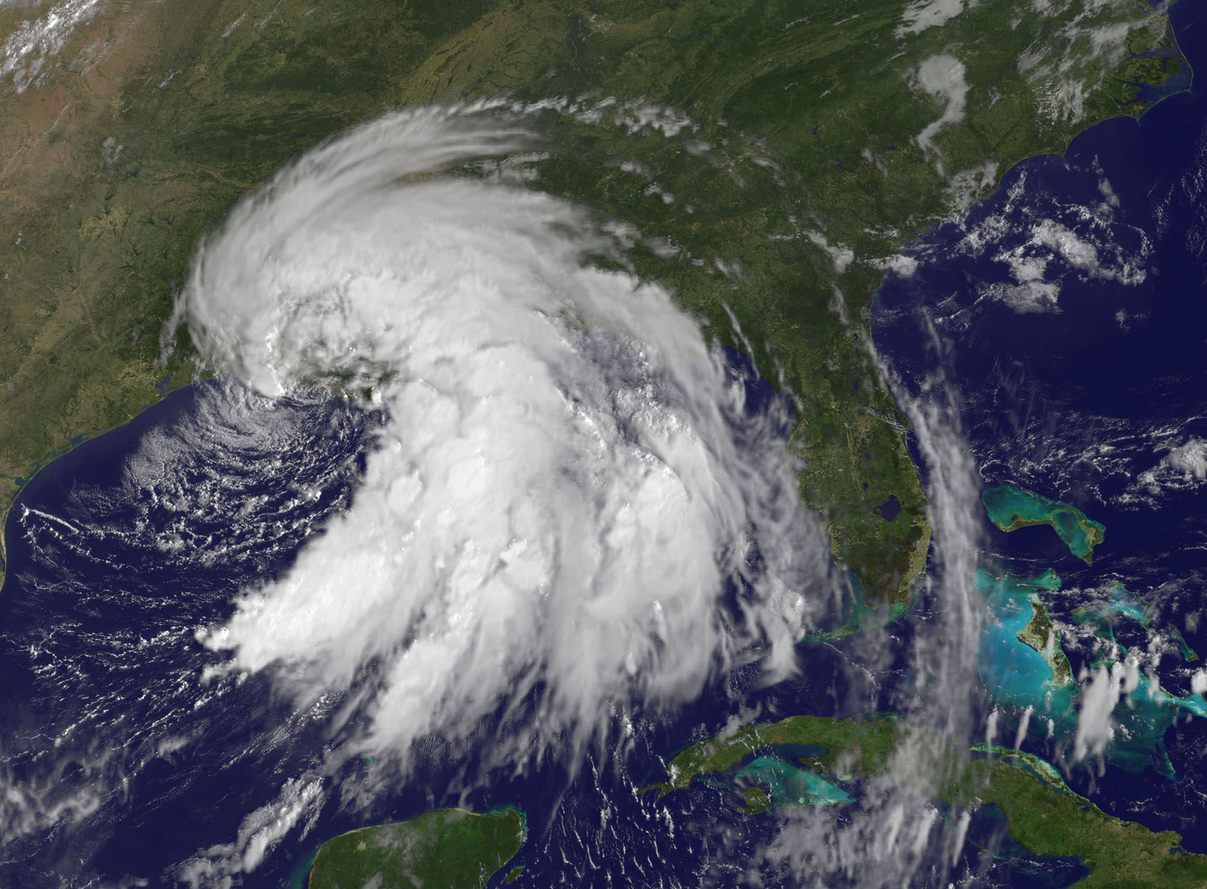
Hurricane Sandy is now in the Caribbean as a Category 2 storm coastal areas from Florida to Maine will feel some effects, forecasters predict. The mix of the two storms could cause weather problems in the Washington DC area to New York city, some of the most populous areas of the US.
Satellite image of then Tropical Storm Sandy taken on October 23, 2012 as it was over the Caribbean Sea taken by the Moderate Resolution Imaging Spectroradiometer (MODIS) on NASA’s Terra satellite. NASA image courtesy Jeff Schmaltz, LANCE MODIS Rapid Response Team at NASA GSFC.
Forecasters are saying this could be a major mess, with a 90 percent chance that the East will get steady gale-force winds, heavy rain, flooding and maybe snow.
While no one can positively predict what Hurricane Sandy will do and how the two storms might mesh into one monster storm, the Washington Post’s Capital Weather Gang has outlined the possible scenarios from worst case to where the storms collide and remained parked over the region for days, to best case, where Sandy heads to the northeast sparing the East Coast from a direct hit.
We’ll post additional updated satellite views as they become available.
This visible image of Tropical Storm Isaac taken from NOAA’s GOES-13 satellite shows the huge extent of the storm, where the eastern-most clouds lie over the Carolinas and the western-most clouds are brushing east Texas. The image was captured on Tuesday, Aug. 28, 2012 at 10:25 a.m. EDT. Image Credit: NASA GOES Project
As expected Tropical Storm Isaac has now become a full-fledged hurricane, after being fed by the warm waters in the Gulf of Mexico. The slow moving storm is now closing in on the Louisiana-Mississippi coast and could make landfall in the region seven years to the day after Hurricane Katrina devastated the same area. It is not expected to be another Katrina, but with the slowness of the storm — about 16 km/h (10 mph) — forecasters are predicting 7-14 inches of rainfall across the coast as well as inland regions, and some places could even see 20 inches. Flooding from rainfall and storm surges are expected, according to NOAA. Satellites have been keeping an eye on the storm, and above is an image from one of the GOES satellites taken on Tuesday, August 28. Below are more satellite views.
The Proba-2 satellite’s X-Cam – Exploration Camera – acquired this image at 11:38:33 GMT on August 27, 2012. Credit: ESA
The Moderate Resolution Imaging Spectroradiometer (MODIS) on NASA’s Aqua satellite captured this natural-color image of Isaac over the Gulf of Mexico at 2:00 p.m. CDT on August 27, 2012. Credit: NASA
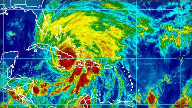
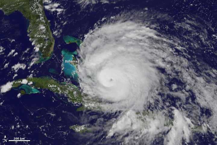
Hurricane Rina's location and forecasted path as of 7 am CDT on Oct 26, 2011. Credit: NOAA
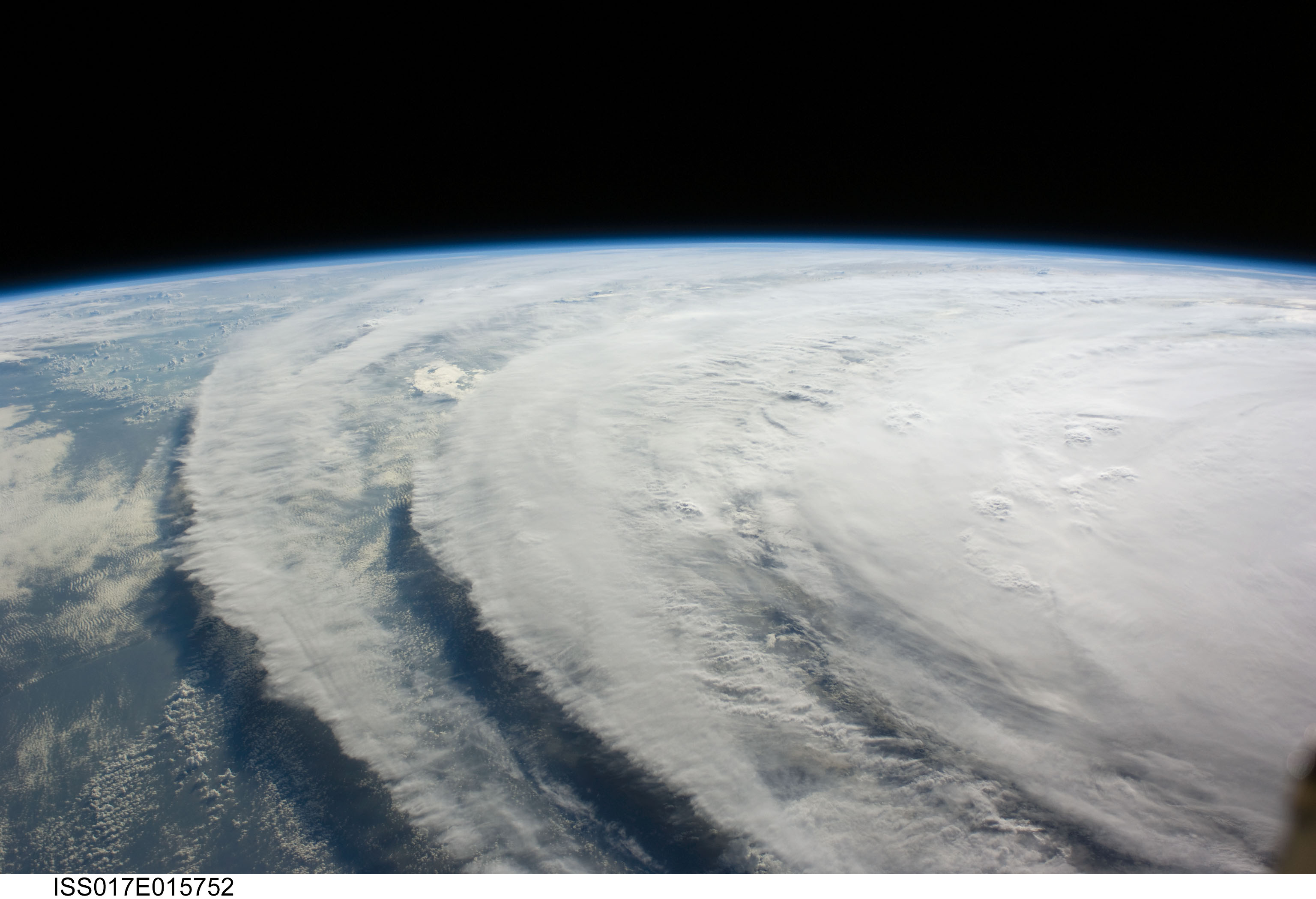
“It’s a big one!” said International Space Station commander Mike Fossum as the space station flew over Hurricane Rina at 2:39 p.m. EDT on Oct. 25, 2011. External cameras on the ISS captured these views as the station flew 248 miles over the Caribbean Sea east of Belize.
Rina’s maximum sustained winds remained steady at about 110 mph early Wednesday, said the U.S. National Hurricane Center in Miami, making it a Category 2 storm. Forecasters predict it will strengthen to a major hurricane as it nears the Mexican coast Wednesday night before rolling over the island of Cozumel, then along the coast to Cancun.
See a map of the Hurricane’s projected path below.
The late season hurricane, which continues to intensify, was located 300 miles east-southeast of Chetumal, Mexico, barely moving west-northwest at a glacial three miles an hour. Hurricane warnings have been issued for the Yucatan from north of Punta Gruesa, Mexico, to Cancun.
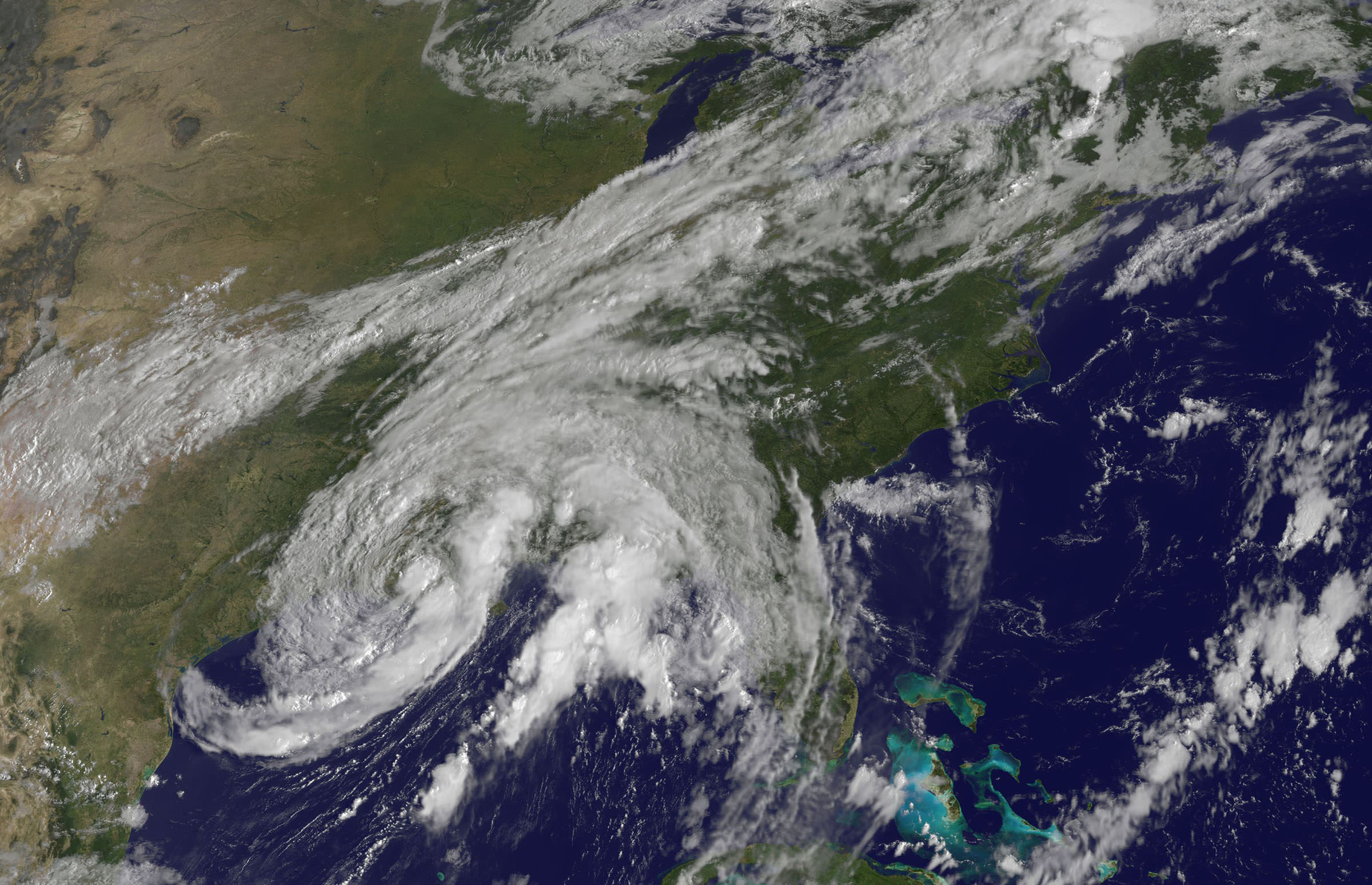
Tropical Storm Lee - Visible image from the GOES-13 satellite on Sunday, Sept. 4 at 9:32 a.m. EDT. It shows the extent of Lee's cloud cover over Louisiana, Mississippi, Alabama and the Florida Panhandle and spread into the Tennessee Valley. The thickest clouds and heaviest rainfall stretch from the northeast to southwest of the center. Credit: NASA/NOAA GOES Project
[/caption]
New imagery from NASA and NOAA satellites taken today (Sept 4) shows the extent of a hurricane season storm currently ravaging the US Gulf Coast and another potentially posing a new threat to US East Coast areas still suffering from the vast destruction caused by Hurricane Irene just days ago. Data from the NASA and NOAA satellites is critical in providing advance warning to government officials and local communities to save human lives and minimize property damage. .
Slow moving Tropical Storm Lee has unleashed strong thunderstorms and heavy rainfall in several Gulf Coast states. Rainfall amounts of up to 7 to 14 inches over the last 48 hours are currently drenching coastal and inland communities – especially in Louisiana, Mississippi and Alabama along a wide swath that extends from Texas to the Florida panhandle.
Isolated pockets of Gulf State areas may see up to 20 inches of rainfall. Severe flooding to homes and roads has occurred in some locations. Winds have diminished from 60 mph on Saturday (Sept. 3) to 45 mph on Sunday.
Imagery and measurements from the Aqua and GOES-13 satellites from NASA and NOAA revealed that TS Lee finally made landfall in Louisiana after two days of drenching rain along the Gulf Coast..
A tropical storm warning is in effect on Sept 4 for New Orleans, Lake Pontchartrain, and Lake Maurepas. Fortunately the rebuilt levees in New Orleans appear to holding in the first serious test since the vast destruction of Hurricane Katrina. Other areas are less lucky.
This infrared image of Tropical Storm Lee on Sept. 3 at 3:47 p.m. EDT when the center was still sitting south of the Louisiana coast. The strongest thunderstorms and coldest clouds (purple) stretched from Mobile Bay, south into the Gulf of Mexico and covered about 1/3rd of the Gulf of Mexico. Winds were 55 mph at the time of this image. The image was taken by the AIRS instrument on NASA's Aqua satellite. Credit: NASA JPL, Ed Olsen NASA
Lee’s tropical force winds now extend out 275 miles from the center. A large part of Lee is still over the Gulf of Mexico where the driving wind and rain affected operations on some oil rigs.
Lee has spawned more than a dozen tornadoes in the Gulf Coast states. The storm is spreading more heavy rain and winds on a northeast to east- northeast heading tracking towards Tennessee over the next 24 to 36 hours according to the latest weather forecasts.
Meanwhile Hurricane Katia is packing winds of 110 MPH and is on a path that could cause it to make landfall on the Outer Banks of North Carolina just a week after the state suffered from Hurricane Irene.
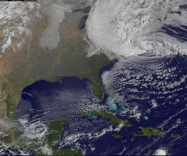
This GOES-13 satellite image shows Hurricane Katia (right), Tropical Depression 13 (left) and System 94L (top). Credit: NASA/NOAA GOES Project
Irene caused extensive flooding and devastation on the hundred year scale in several US states still reeling from flooding and destruction. More than 43 deaths have been reported so far, including emergency rescue workers. Initial damage estimates are over $6 Billion.
Thousands of East Coast homes and businesses are still without power as strong after effects from Irene continue to play out.
President Obama toured flood stricken areas of Paterson, New Jersey today (Sept. 4).
According to a statement by Rob Gutro, of NASA’s Goddard Space Flight Center, Greenbelt, Md; Tropical Storm Lee’s winds had dropped from 60 mph exactly 24 hours before to 45 mph at 8 a.m. EDT on Sept. 4.
Lee’s center was over Vermillion Bay, Louisiana near 29.7 North and 92.0 West. It was crawling to the northeast near 3 mph (6 kmh) and expected to continue in that direction today, turning to the east-northeast tonight. Because Lee’s center is over land, he is expected to continue weakening gradually in the next couple of days. Lee’s outer bands still extend far over the Gulf of Mexico, bringing in more moisture and keeping the system going.
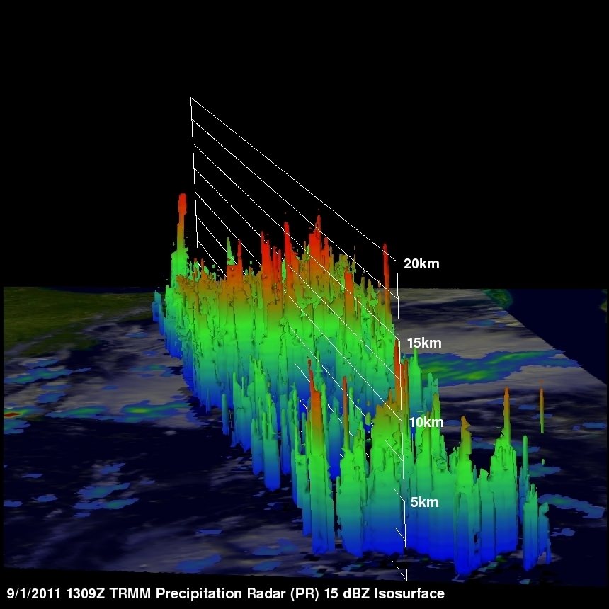
Here's a 3-D look at Tropical Depression 13 from NASA's TRMM Satellite on Sept 1. Some of the highest thunderstorm towers in that area were shown by PR data to reach heights of over 15km (~9.3 miles) and there were areas of heavy rain - which is going to affect the shoreline.. waves of rainfall to move inland. Credit: NASA/GoddardThis visible image of Tropical Storm Lee was taken from the GOES-13 satellite on Saturday, Sept. 3 at 9:32 a.m. EDT. It shows the extent of Lee's cloud cover over Louisiana, Mississippi, Alabama and the Florida Panhandle. The clearing on the southeastern side is a result of drier air moving in and preventing development of thunderstorms. Credit: NASA/NOAA GOES Project
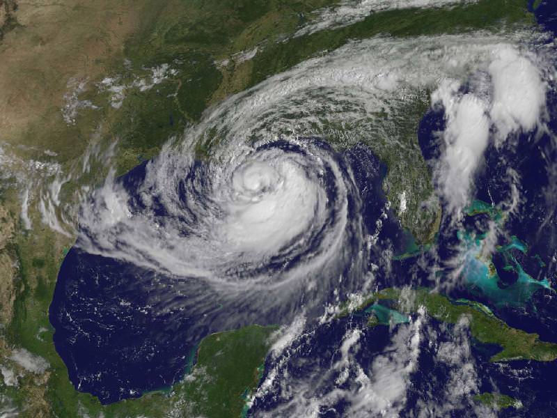
GOES satellite image of Hurricane Irene as of 18:15 UTC on August 26, 2011. Credit: NOAA
What a view: Here’s a video of Hurricane Irene’s path, starting on August 24 up until 18:40 UTC on August 26, 2011, as seen by a GOES satellite. Even though Hurricane Irene is continuing to slowly weaken as it pushes closer to the Carolina coast, this massive storm could affect a huge area of the Eastern US seaboard, and tropical storm force winds and squalls are buffeting the coast. Irene will impact the entire Mid-Atlantic and Northeast Coast, including Washington, Philadelphia, New York City, Hartford, Ct. and Boston this weekend.
This hurricane spans nearly 1,000 kilometers (600 miles).
Below is a video taken from the International Space Station late yesterday afternoon. Includes astronaut commentary on the view of this “huge, scary storm” from 370 km (230 miles) up:
Cameras mounted on the International Space Station captured this video. Forecasters are predicting landfall on the outer banks of North Carolina Saturday before tracking up the mid-Atlantic states and a possible path over the metropolitan New York area and New England late this weekend.
[/caption]
Hot off the wires is this satellite image of Hurricane Irene taken less than an hour ago (as of this writing) by one of the GOES satellites for NOAA.
A view of Hurricane Irene taken by the GOES satellite at 2:55 p.m. Eastern Daylight Time on August 24, 2011. Credit: NASA
Here are several different views of Hurricane Irene: from 230 miles above the Earth, cameras on the International Space Station captured several views of powerful Hurricane Irene as it churned over the Bahamas at 3:10 p.m. EDT on August 24, 2011. Irene is moving to the northwest as a Category 3 hurricane, packing winds of 120 miles an hour. Irene is expected to strengthen to a Category 4 storm as it heads toward the Outer Banks of North Carolina, the Eastern Seaboard and the middle Atlantic and New England states.
See more from other satellites, below:
[/caption]
This view of Irene was taken by the GOES satellite at 2:55 p.m. Eastern Daylight Time on August 24, 2011. Irene now has a distinct eye and the clouds spiraling around the center are becoming more compact. The image also shows how large Irene has become, measuring several hundred kilometers across.
A three dimensional perspective of Irene, showing rainfall. Credit: NASA/TRMM satellite
This image was taken on August 22, but is a really nifty, three-dimensional view of the precipitation from Irene, as seen by the Tropical Rainfall Measuring Mission. It reveals an area of deep convection (shown in red) near the storm’s center where precipitation-sized particles are being carried aloft. These tall towers are associated with strong thunderstorms responsible for the area of intense rain near the center of Irene seen in the previous image. They can be a precursor to strengthening as they indicate areas within a storm where vast amounts of heat are being released. This heating, known as latent heating, is what is drives a storm’s circulation and intensification.
As of 8 a.m. EDT on August 25, Hurricane Irene was located near 25.5 N and 76.5 W, or 65 miles east-southeast of Nassau, Bahamas. This places it about 670 miles south of Cape Hatteras, N.C. Irene`s top sustained winds remain at 115 mph, and is moving to the northwest at 13 mph.
What is a hurricane? Well, a hurricane is a tropical cyclone that occurs in the North Atlantic Ocean or the Northeast Pacific Ocean and remains east of the International Dateline. Tropical cyclones are characterized by a large low pressure center and numerous thunderstorms. These produce strong winds and heavy rain. These cyclones feed on heat released when moist air rises causing condensation of the water vapor that is contained in the moist air. These storms are fueled by a different heat mechanism than other cyclonic windstorms(nor’easters, polar lows, and European windstorms). They are classified as a warm core storm system.
All tropical cyclones are areas of low atmospheric pressure. As a matter of fact, the pressures recorded at the center of tropical cyclones are among the lowest that occur at sea level. A hurricane is characterized and driven by the release of large amounts of latent heat of condensation(water vapor condenses as it moves upward). This heat is distributed vertically around the center of the storm, so, except at the surface of water, it is warmer inside the cyclone than it is outside. At the center of the hurricane is an area of sinking air. If this area is strong enough, it can develop into a large eye. Weather in the eye is normally calm and free of clouds, but the surface of the sea may be tossing violently. The eye is normally circular in shape, and may range in size from 3 km to 370 km in diameter.
While a tropical cyclone’s primary energy source is the release of the heat of condensation, solar heating is the initial source of that evaporation. An initial warm core system(an organized thunderstorm complex) is necessary for the formation of a tropical cyclone, but a large flux of energy is needed to lower atmospheric pressure. The influx of warmth and moisture from the underlying ocean surface is critical for tropical cyclone strengthening and most of it comes from the lower 1 km of the atmosphere. Condensation leads to higher wind speeds. These faster winds and the lower pressure associated with them cause an increase in surface evaporation and more condensation. This positive feedback system continues and feeds the hurricane until the conditions for hurricane formation are gone. The rotation of Earth causes the system to spin,(the Coriolis effect) which gives it a cyclonic appearance and affects its trajectory.
Tropical cyclones are distinguished by the deep convection that fuels them. Since convection is strongest in the tropics it defines the initial domain of the tropical cyclone. To continue to feed itself a tropical cyclone must remain over warm water. When a tropical cyclone passes over land, it is cut off from its heat source and its strength diminishes rapidly. The passage of a tropical cyclone over the ocean can cause the upper layers of the ocean to cool substantially, which can influence subsequent cyclone development. Scientists at the National Center for Atmospheric Research in the US estimate that a tropical cyclone releases heat energy equal to 70 times the world energy consumption, 200 times the worldwide electrical generating capacity, or the same as exploding a 10 megaton nuclear bomb every 20 minutes.
Well, there you have the answer to what is a hurricane. It is a tropical nightmare, but if humans could somehow harness that energy we would never need fossil fuels again.
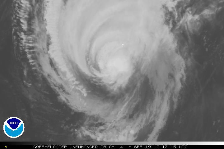
Hurrican Igor as seen by one of the GOES satellites, taken on Sept. 19, 2010 at 17:15 UTC. Credit: NOAA
[/caption]
The massive Hurricane Igor is now a Category One storm, with maximum sustained wind speeds of 140 km per hour, (85 miles per hour). As of this writing at 2:30 EDT, it looks as if it is on a direct collision course with Bermuda and is about 220 km (135 miles) southwest of Bermuda. The intensity of the storm has decreased over the past few days, but the size and rotation of the Igor means that Bermuda will be hit repeatedly as the arms of the hurricane spin over the 54 square kilometer (21 sq mi) island nation. In the satellite image above, Bermuda is the small white dot near the center of the image.
Projected track of Hurricane Igor. Credit: NOAA
Damaging sustained winds of hurricane force will reach the Bermuda late Sunday afternoon, and they will continue into early Monday morning. Wind gusts are predicted to be near or just over 160 km/hour (100 mph) as Igor makes its closest approach to Bermuda. Here’s a link to even more hurricane images.
The hurricane threatens to leave widespread tree damage and power outages in its wake. Some structures will also sustain damage; but fortunately, many buildings on Bermuda are made of stone with foundations into bedrock.
Flooding is also a serious concern across Bermuda. Igor will not only drop 4 to 8 inches of rain but will also trigger a 6- to 10-foot storm surge. Worsening the situation is the fact that waves pounding Bermuda will rise to heights in excess of 40 feet into this evening.
The massive size of Igor will cause the hurricane to keep battering the island well into Monday afternoon.
This 3-D image of Igor's cloud heights and rainfall from NASA TRMM satellite. Credit: Credit: NASA/SSAI, Hal Pierce
This 3-D image of Igor’s cloud heights and rainfall from NASA TRMM data shows a large area of heavy rainfall (falling at about 2 inches per hour) shown here in red on Sept. 15 at 0353 UTC. The yellow and green areas indicate moderate rainfall between .78 to 1.57 inches per hour. The image reveals that Igor’s eye was still very distinct but the southwestern portion of the eye wall had eroded.
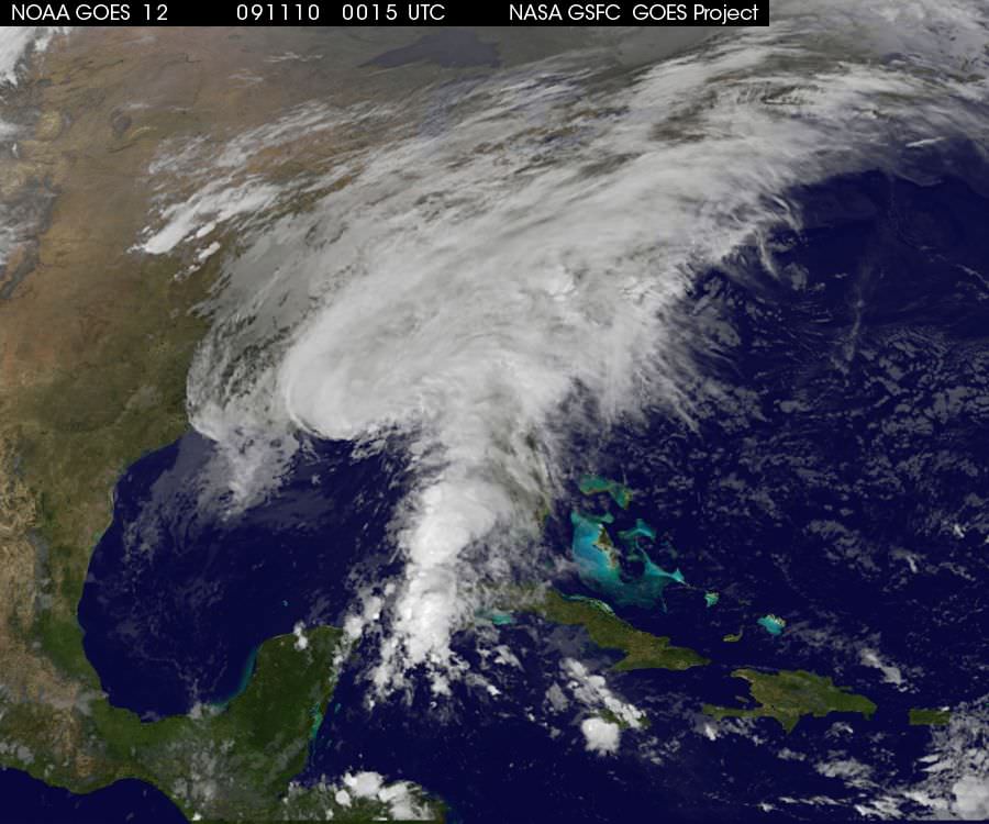
The GOES-12 satellite is monitoring the status of tropical storm Ida to help in predicting its path. Image Credit: GOES Project Science
NASA has been keeping an eye on tropical storm Ida off the Gulf Coast, which was downgraded from a hurricane earlier today. Its satellites have been helping meteorologists to measure the rainfall and windspeeds of the storm. Ida is predicted by the National Hurricane Center in Miami, Florida to make landfall near Pensacola, Florida on Tuesday morning (Nov. 10th), after which it is expected to drop in intensity and head East.
NASA has been using three different satellites to monitor the tropical storm. The Tropical Rainfall Measuring Mission (TRMM) satellite flew over the storm earlier today, just before it was downgraded from hurricane status. At that time, the data from TRMM showed scattered convective thunderstorms producing moderate to heavy rainfall of about 50mm (2 inches) per hour. The windspeeds were measured at 70 knots (80.5 mph), but have since dropped.
The Quick Scatterometer satellite (QuikScat) used microwaves to observe Ida’s winds. The satellite data showed the speed of the rotating winds in the storm near the ocean surface to be 50-55 knots (57-63 mph) at 7a.m. Eastern Time. The tropical force winds extend out up to 200 miles from the center of Ida.
The third satellite NASA is using is the Geostationary Operational Environmental Satellite, GOES-12. From the imaging taken with GOES-12, the GOES Project at NASA’s Goddard Space Flight Center in Greenbelt, Md. was able to make a movie of the storm’s movement from November 7th-9th. The movie and many other images of the storm, updated hourly, are available on the GOES Project Science website.
Though Ida is not a hurricane, it still poses a significant threat to those living in the region where it will make landfall. The National Hurricane Center noted that “Large and destructive waves will accompany a storm surge of 3 to 5 feet near the point of landfall.” Local advisories are in effect on the ground for residents of the Gulf coast from the Florida panhandle to New Orleans and Baton Rouge, Louisiana. These areas and more northern areas into eastern Tennessee Valley and southern Appalachians can expect 3 to 5 inches of rainfall, with isolated totals of 8 inches.
If you live in these areas, please take care to follow any official advisories on the storm, available on the National Hurricane Center website.


 on the Terra satellite on August 25. Credit: NASA")