In addition to being the birthplace of humanity and the cradle of human civilization, Earth is the only known planet in our Solar System that is capable of sustaining life. As a terrestrial planet, Earth is located within the Inner Solar System between between Venus and Mars (which are also terrestrial planets). This place Earth in a prime location with regards to our Sun’s Habitable Zone.
Earth has a number of nicknames, including the Blue Planet, Gaia, Terra, and “the world” – which reflects its centrality to the creation stories of every single human culture that has ever existed. But the most remarkable thing about our planet is its diversity. Not only are there an endless array of plants, animals, avians, insects and mammals, but they exist in every terrestrial environment. So how exactly did Earth come to be the fertile, life-giving place we all know and love?
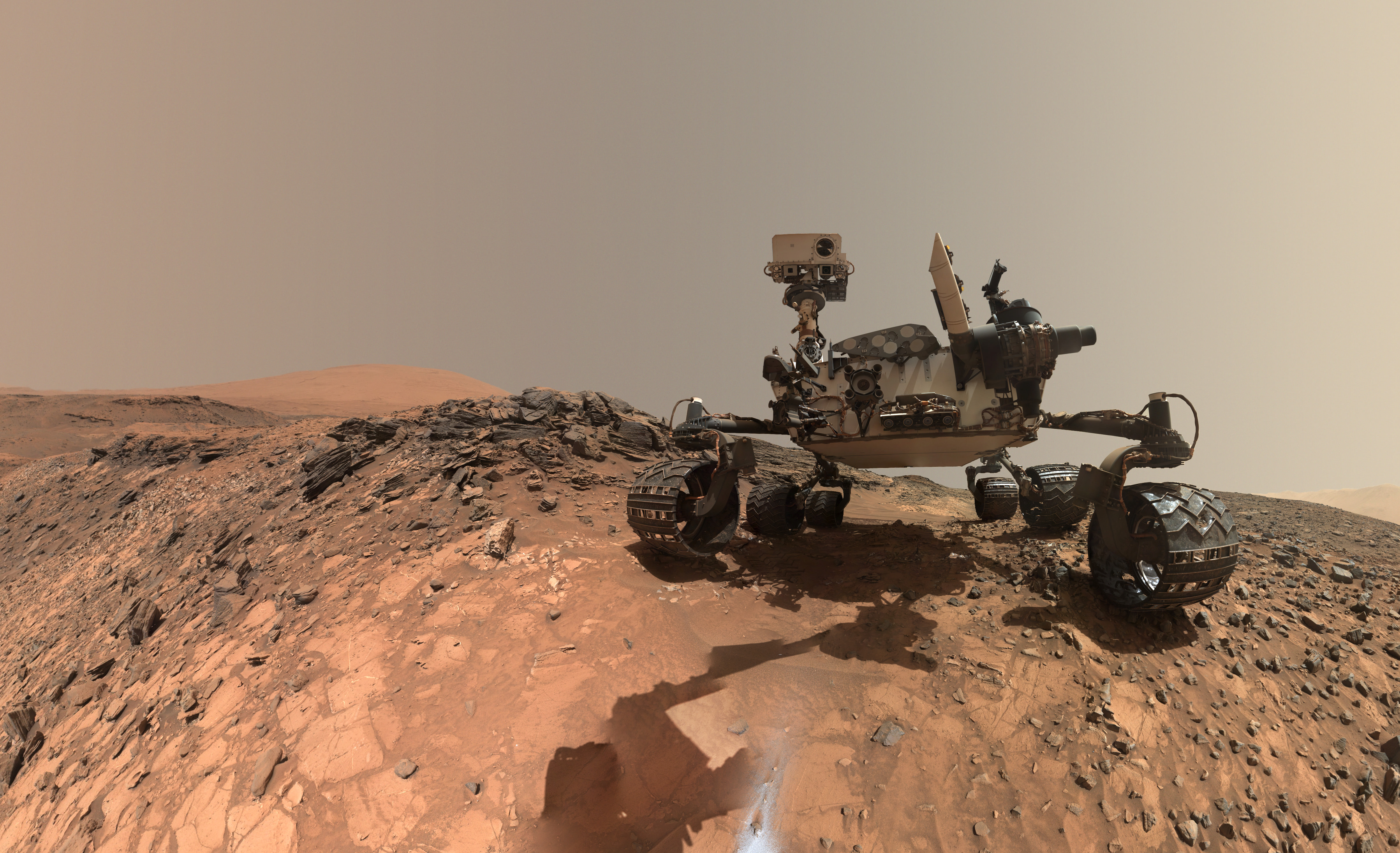
This low-angle self-portrait of NASA's Curiosity Mars rover shows the vehicle at the site from which it reached down to drill into a rock target called "Buckskin." The MAHLI camera on Curiosity's robotic arm took multiple images on Aug. 5, 2015, that were stitched together into this selfie. Credits: NASA/JPL-Caltech/MSSS
This low-angle self-portrait of NASA’s Curiosity Mars rover shows the vehicle at the site from which it reached down to drill into a rock target called “Buckskin.” The MAHLI camera on Curiosity’s robotic arm took multiple images on Aug. 5, 2015, that were stitched together into this selfie. Credits: NASA/JPL-Caltech/MSSS
More selfie and drilling mosaics below[/caption]
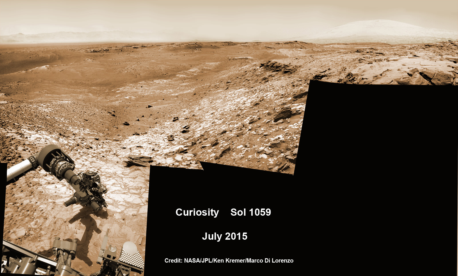
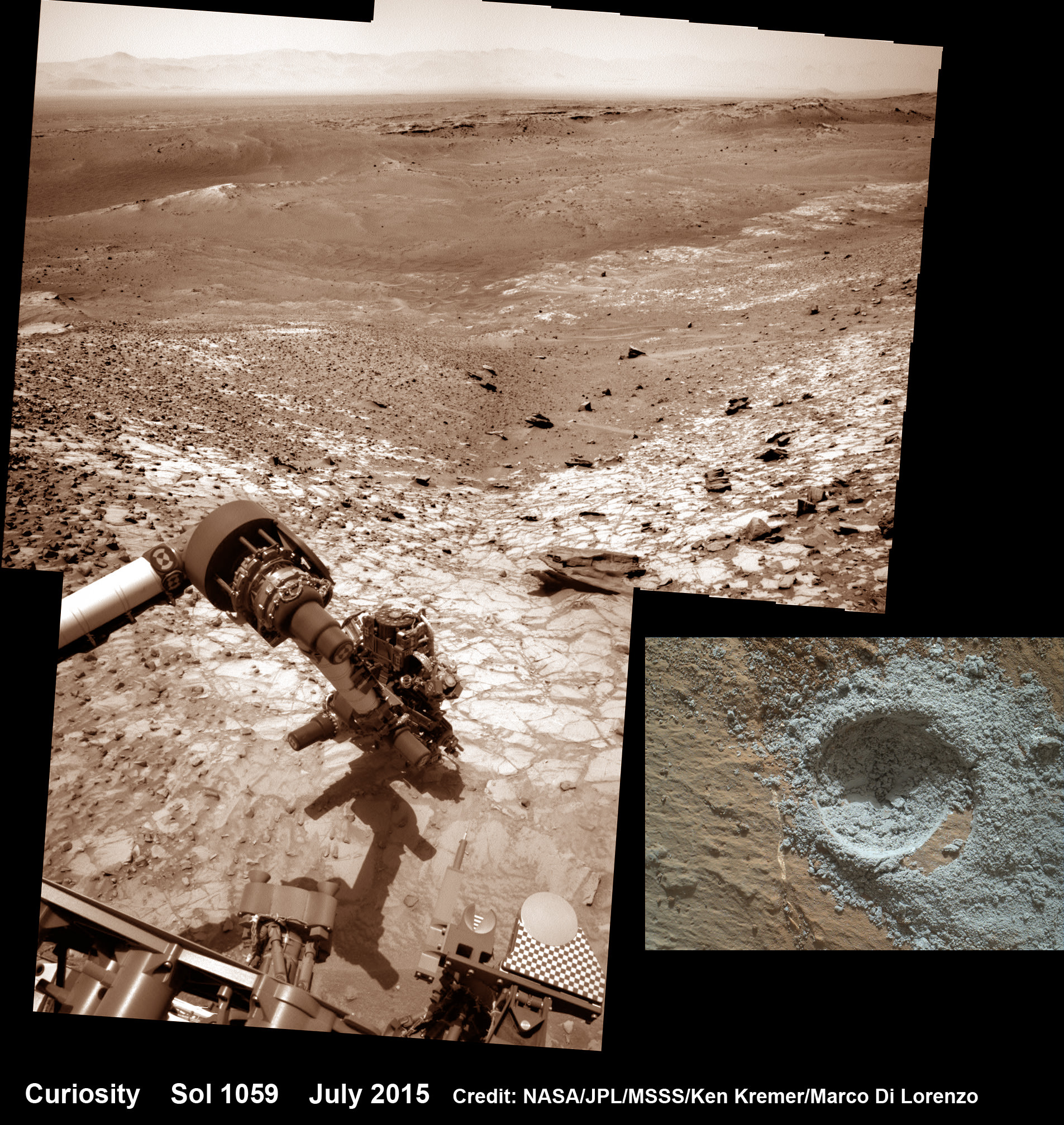
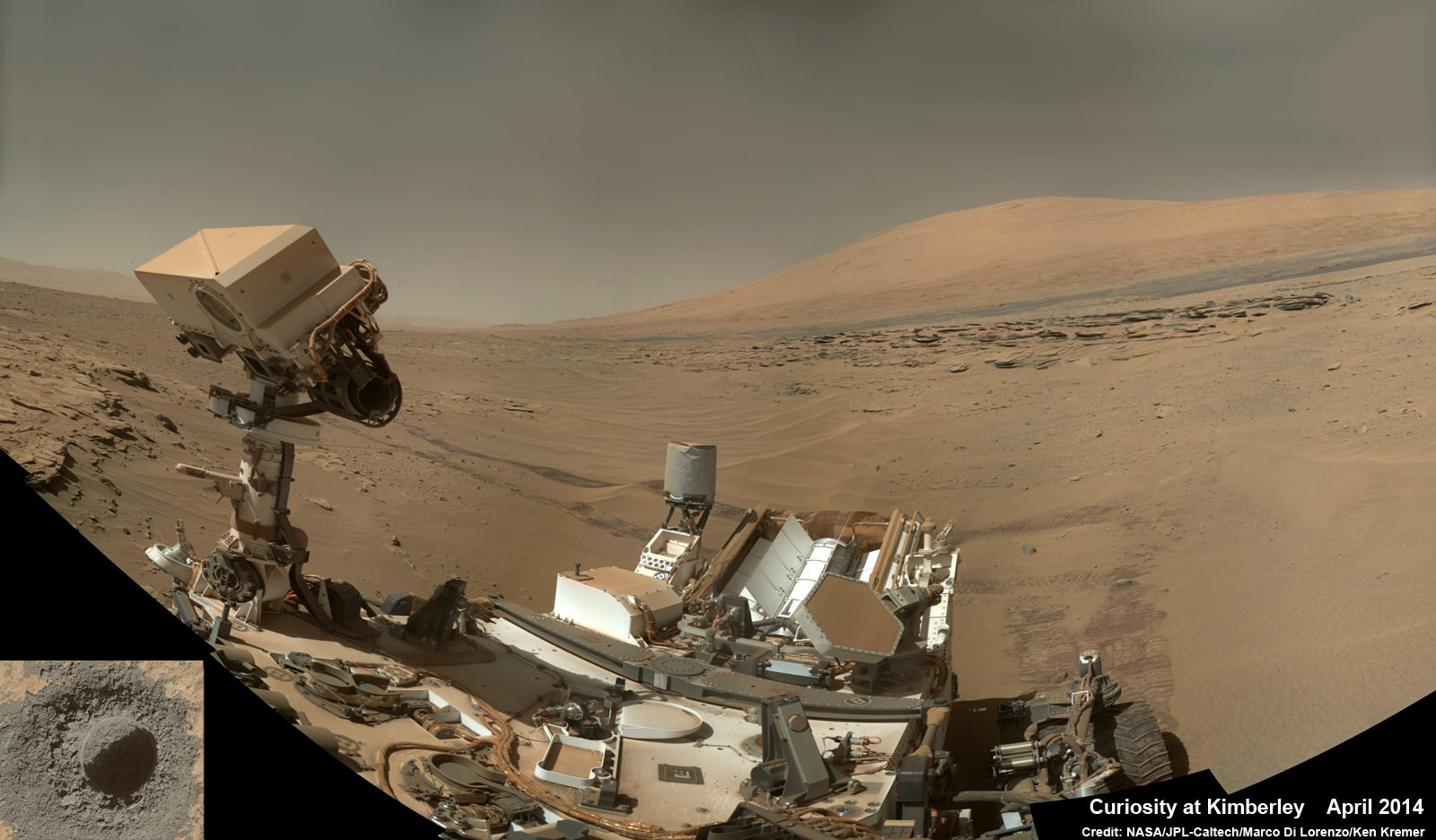
The unique self portrait was taken from a low-angle for the first time and shows the six wheeled rover at work collecting her seventh drilled sample at the ‘Buckskin’ rock target earlier this month in the “Marias Pass” area of lower Mount Sharp.
‘Buckskin’ is also unique in a fabulously scientifically way because the rover discovered a new type of Martian rock that’s surprisingly rich in silica – and unlike any other targets found before.
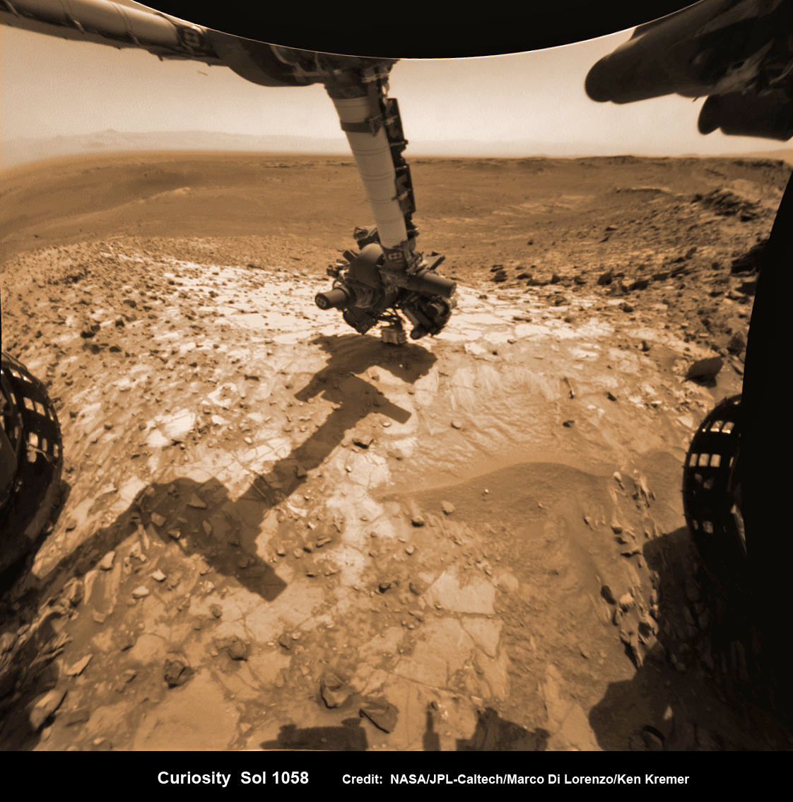
The low camera angle is what enables the awesome Buckskin belly selfie. It’s a distinctively dramatic view and actually stitched from 92 images captured by the Mars Hand Lens Imager (MAHLI) on Aug. 5, 2015, or Sol 1065 of the mission.
The high resolution MAHLI color camera is located on the end of the 7 foot-long (2.1 meter-long) robotic arm.
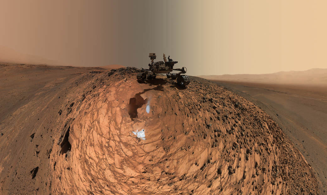
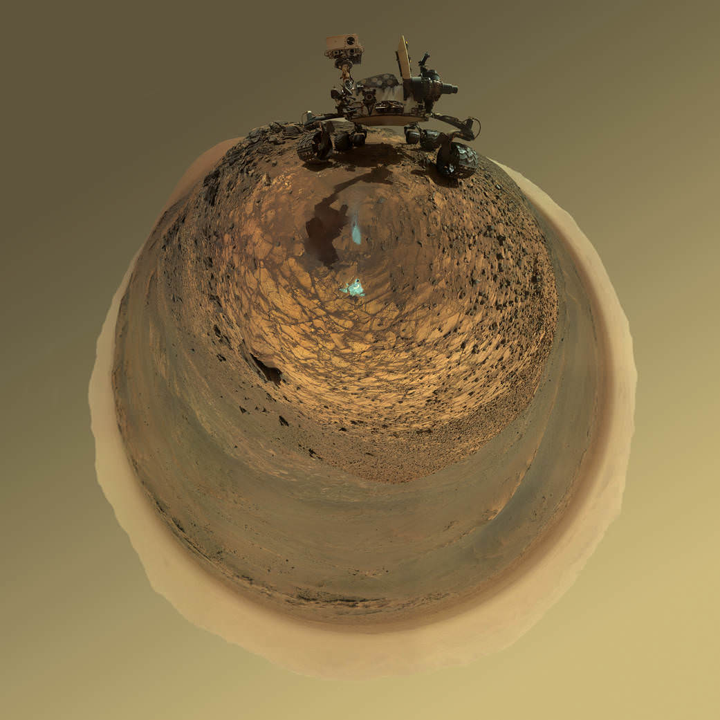
This version of a self-portrait of NASA’s Curiosity Mars rover at a drilling site called “Buckskin” is presented as a stereographic projection, which shows the horizon as a circle. The MAHLI camera on Curiosity’s robotic arm took dozens of component images for this selfie on Aug. 5, 2015. Credits: NASA/JPL-Caltech/MSSS
Indeed the car-sized rover has taken spectacular selfies several times before during her three year long trek across the Martian surface, since the August 2012 landing inside Mars’ Gale Crater. But for those past selfies the MAHLI camera was hoisted higher to give the perspective of looking somewhat downward and showing the rovers top deck and trio of sample inlet ports.
In this case, the rover team specifically commanded Curiosity to position “the camera lower in relation to the rover body than for any previous full self-portrait of Curiosity,” said NASA officials.
Two patches of gray colored powdered rock material drilled from Buckskin are visible in the selfie scene, in front of the rover.
“The patch closer to the rover is where the sample-handling mechanism on Curiosity’s robotic arm dumped collected material that did not pass through a sieve in the mechanism. Sieved sample material was delivered to laboratory instruments inside the rover. The patch farther in front of the rover, roughly triangular in shape, shows where fresh tailings spread downhill from the drilling process.”
Prior selfies were taken at the “Rocknest” (http://photojournal.jpl.nasa.gov/catalog/PIA16468), “John Klein” (http://photojournal.jpl.nasa.gov/catalog/PIA16937), “Windjana” (http://photojournal.jpl.nasa.gov/catalog/PIA18390) and “Mojave” drill sites.
Basically in the Sol 1065 belly selfie at “Buckskin” we see the underbelly of the rover and all six wheels along with a complete self portrait.
This version of a self-portrait of NASA’s Curiosity Mars rover at a drilling site called “Buckskin” is presented as a stereographic projection, which shows the horizon as a circle. The MAHLI camera on Curiosity’s robotic arm took dozens of component images for this selfie on Aug. 5, 2015. Credits: NASA/JPL-Caltech/MSSS
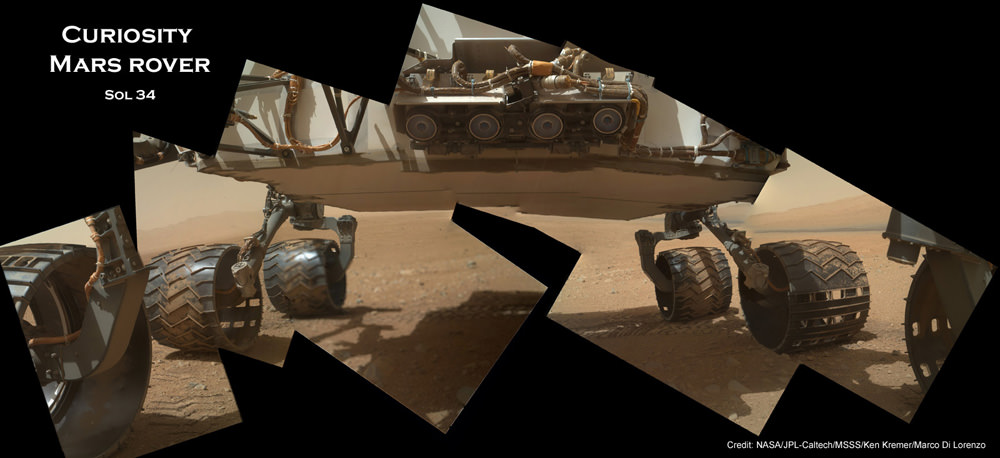
On several prior occasions, MAHLI was used to image just the underbelly and wheels to aid in inspecting the wheels to look for signs of damage inflicted by sharp-edged Martian rocks poking holes in the aluminum wheels.
Underbelly view of Curiosity rover and wheels on Sol 34, Sept. 9, 2012. Credit: NASA/JPL/MSSS/Ken Kremer/Marco Di Lorenzo
Each wheel measures 20 inches (50 centimeters) in diameter and about 16 inches (40 centimeters) wide. And the MAHLI monitoring images have shown the effects of increasing wear and tear that ultimately forced the rover drivers to alter Curiosity’s driving route on the crater floor in favor of smoother and less rocky terrain imparting less damage to the critical wheels.
If you take a close look at the new selfie up top, you’ll see a small rock stuck onto Curiosity’s left middle wheel (on the right in this head-on view). The rock was seen also in prior wheel monitoring images taken three weeks ago.
“The selfie at Buckskin does not include the rover’s robotic arm beyond a portion of the upper arm held nearly vertical from the shoulder joint. With the wrist motions and turret rotations used in pointing the camera for the component images, the arm was positioned out of the shot in the frames or portions of frames used in this mosaic,” according to officials.
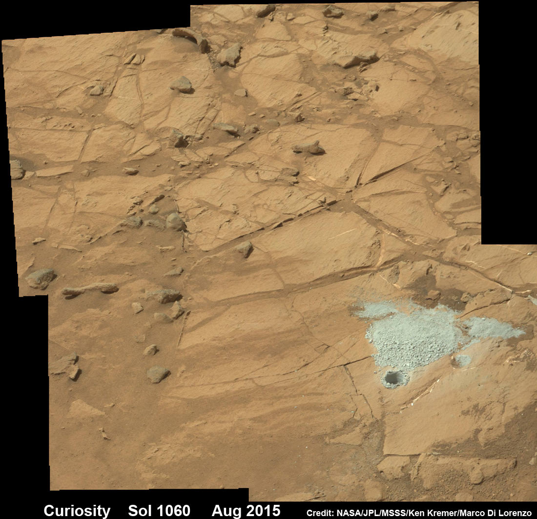
The drilling campaign into “Buckskin” was successfully conducted on Sol 1060 (July 30, 2015) at the bright toned “Lion” outcrop to a full depth of about 2.6 inches (6.5 centimeters) and approximately 1.6 cm (0.63 inch) diameter.
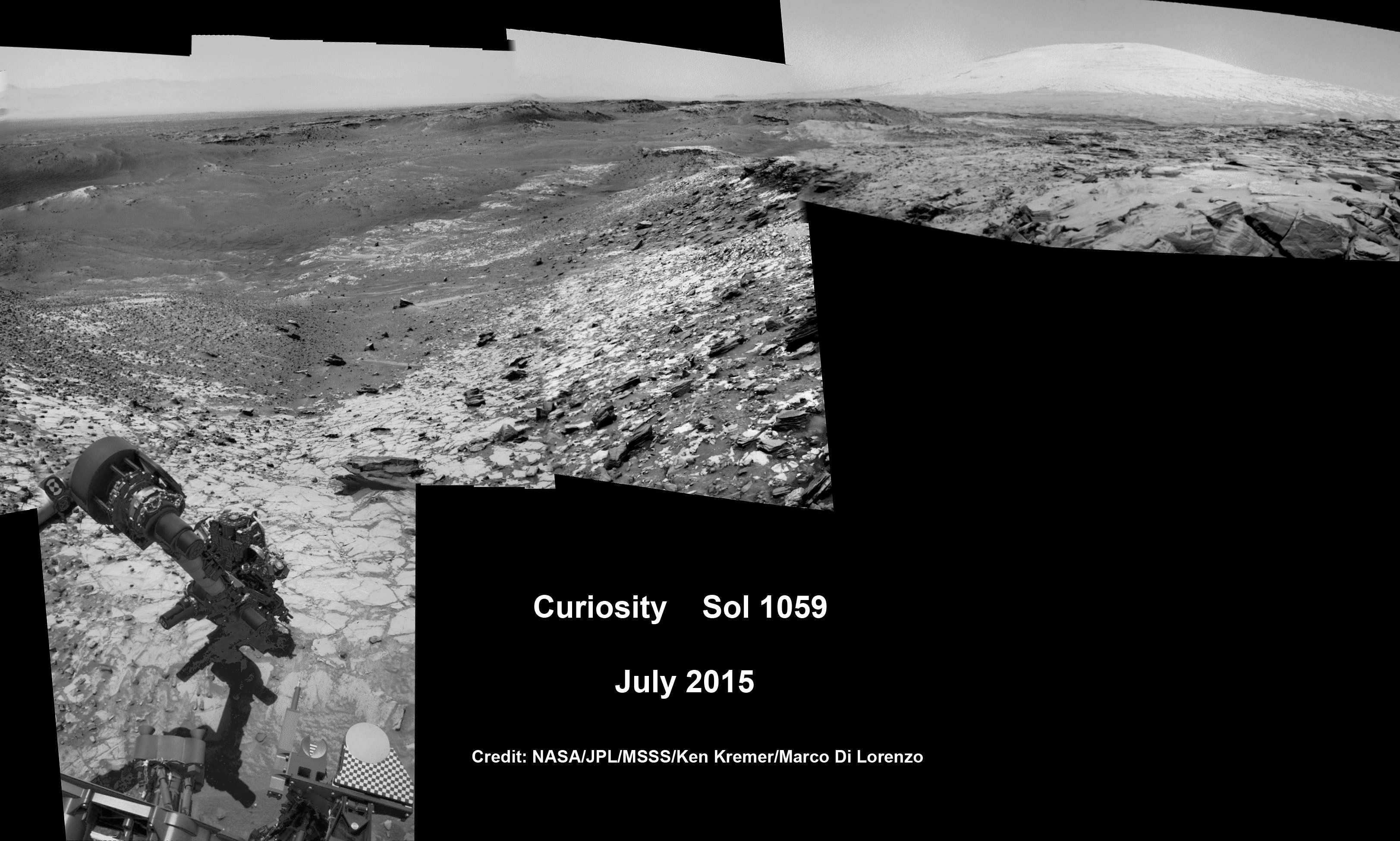
Curiosity extends robotic arm and conducts sample drilling at “Buckskin” rock target at bright toned “Lion” outcrop at the base of Mount Sharp on Mars, seen at right. Gale Crater eroded rim seen in the distant background at left, in this composite multisol mosaic of navcam raw images taken to Sol 1059, July 30, 2015. Navcam camera raw images stitched and colorized. Inset: MAHLI color camera up close image of full depth drill hole at “Buckskin” rock target on Sol 1060. Credit: NASA/JPL-Caltech/MSSS/Ken Kremer/kenkremer.com/Marco Di Lorenzo
You can also see another perspective of the rover at work while reaching out with the robotic arm and drilling into ‘Buckskin’ as illustrated in our mosaics of mastcam and navcam camera raw images created by the image processing team of Ken Kremer and Marco Di Lorenzo.
The main bore hole was drilled next to the initial mini hole test and shows the indicative residue of grey colored tailings from the Martian subsurface seen distributed around the new hole.
Curiosity rover successfully drills into Martian outcrop at Buckskin rock target at current work site at base of Mount Sharp in August 2015, in this mosaic showing full depth drill hole and initial test hole, with grey colored subsurface tailings and mineral veins on surrounding Red Planet terrain. This high resolution photo mosaic is a multisol composite of color images taken by the mast mounted Mastcam-100 color camera up to Sol 1060, July 31, 2015. Credit: NASA/JPL-Caltech/Ken Kremer/kenkremer.com/Marco Di Lorenzo
Curiosity has now moved on from the “Marias Pass” area.
As of today, Sol 1080, August 20, 2015, she has driven some 6.9 miles (11.1 kilometers) kilometers and taken over 260,000 amazing images.
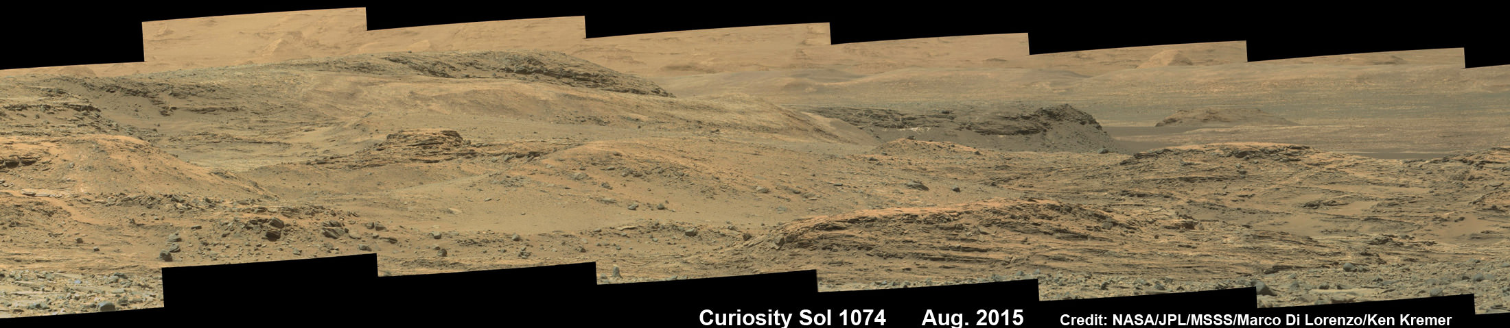
Curiosity rover scans toward south east around Marias Pass area at the base of Mount Sharp on Mars on Sol 1074, Aug. 14, 2015 in this photo mosaic stitched from Mastcam color camera raw images. Credit: NASA/JPL/MSSS/Marco Di Lorenzo/Ken Kremer/kenkremer.com
Curiosity has already accomplished her primary objective of discovering a habitable zone on the Red Planet – at the Yellowknife Bay area – that contains the minerals necessary to support microbial life in the ancient past when Mars was far wetter and warmer billions of years ago.
Stay tuned here for Ken’s continuing Earth and planetary science and human spaceflight news.
Earth Observation of sun-glinted ocean and clouds. Credit: NASA
Earth is the only planet in our Solar System where life is known to exists. Note the use of the word “known”, which is indicative of the fact that our knowledge of the Solar System is still in its infancy, and the search for life continues. However, from all observable indications, Earth is the only place in our Solar System where life can – and does – exist on the surface.
This is due to a number of factors, which include Earth’s position relative to the Sun. Being in the “Goldilocks Zone” (aka. habitable zone), and the existence of an atmosphere (and magnetosphere), Earth is able to maintain a stable average temperature on its surface that allows for the existence of warm, flowing water on its surface, and conditions favorable to life.
Variations:
The average temperature on the surface of Earth depends on a number of factors. These include the time of day, the time of year, and where the temperatures measurements are being taken. Given that the Earth experiences a sidereal rotation of approximately 24 hours – which means one side is never always facing towards the Sun – temperatures rise in the day and drop in the evening, sometimes substantially.
And given that Earth has an inclined axis (approximately 23° towards the Sun’s equator), the Northern and Southern Hemispheres of Earth are either tilted towards or away from the Sun during the summer and winter seasons, respectively. And given that equatorial regions of the Earth are closer to the Sun, and certain parts of the world experience more sunlight and less cloud cover, temperatures range widely across the planet.
However, not every region on the planet experiences four seasons. At the equator, the temperature is on average higher and the region does not experience cold and hot seasons in the same way the Northern and Southern Hemispheres do. This is because the amount of sunlight the reaches the equator changes very little, although the temperatures do vary somewhat during the rainy season.
Measurement:
The average surface temperature on Earth is approximately 14°C; but as already noted, this varies. For instance, the hottest temperature ever recorded on Earth was 70.7°C (159°F), which was taken in the Lut Desert of Iran. These measurements were part of a global temperature survey conducted by scientists at NASA’s Earth Observatory during the summers of 2003 to 2009. For five of the seven years surveyed (2004, 2005, 2006, 2007, and 2009) the Lut Desert was the hottest spot on Earth.
However, it was not the hottest spot for every single year in the survey. In 2003, the satellites recorded a temperature of 69.3°C (156.7°F) – the second highest in the seven-year analysis – in the shrublands of Queensland, Australia. And in 2008, the Flaming Mountain got its due, with a yearly maximum temperature of 66.8°C (152.2°F) recorded in the nearby Turpan Basin in western China.
Meanwhile, the coldest temperature ever recorded on Earth was measured at the Soviet Vostok Station on the Antarctic Plateau. Using ground-based measurements, the temperature reached a historic low of -89.2°C (-129°F) on July 21st, 1983. Analysis of satellite data indicated a probable temperature of around -93.2 °C (-135.8 °F; 180.0 K), also in Antarctica, on August 10th, 2010. However, this reading was not confirmed by ground measurements, and thus the previous record remains.
All of these measurements were based on temperature readings that were performed in accordance with the World Meteorological Organization standard. By these regulations, air temperature is measured out of direct sunlight – because the materials in and around the thermometer can absorb radiation and affect the sensing of heat – and thermometers are to be situated 1.2 to 2 meters off the ground.
Comparison to Other Planets:
Despite variations in temperature according to time of day, season, and location, Earth’s temperatures are remarkably stable compared to other planets in the Solar System. For instance, on Mercury, temperatures range from molten hot to extremely cold, due to its proximity to the Sun, lack of an atmosphere, and its slow rotation. In short, temperatures can reach up to 465 °C on the side facing the Sun, and drop to -184°C on the side facing away from it.
Venus, thanks to its thick atmosphere of carbon dioxide and sulfur dioxide, is the hottest planet in our Solar System. At its hottest, it can reach temperatures of up to 460 °C on a regular basis. Meanwhile, Mars’ average surface temperature is -55 °C, but the Red Planet also experiences some variability, with temperatures ranging as high as 20 °C at the equator during midday, to as low as -153 °C at the poles.
On average though, it is much colder than Earth, being just on the outer edge of the habitable zone, and because of its thin atmosphere – which is not sufficient to retain heat. In addition, its surface temperature can vary by as much as 20 °C due to Mars’ eccentric orbit around the Sun (meaning that it is closer to the Sun at certain points in its orbit than at others).
Since Jupiter is a gas giant, and has no solid surface, an accurate assessment of it’s “surface temperature” is impossible. But measurements taken from the top of Jupiter’s clouds indicate a temperature of approximately -145°C. Similarly, Saturn is a rather cold gas giant planet, with an average temperature of -178 °Celsius. But because of Saturn’s tilt, the southern and northern hemispheres are heated differently, causing seasonal temperature variation.
Uranus is the coldest planet in our Solar System, with a lowest recorded temperature of -224°C, while temperatures in Neptune’s upper atmosphere reach as low as -218°C. In short, the Solar System runs the gambit from extreme cold to extreme hot, with plenty of variance and only a few places that are temperate enough to sustain life. And of all of those, it is only planet Earth that seems to strike the careful balance required to sustain it perpetually.
Variations Throughout History:
Estimates on the average surface temperature of Earth are somewhat limited due to the fact that temperatures have only been recorded for the past two hundred years. Thus, throughout history the recorded highs and lows have varied considerably. An extreme example of this would during the early history of the Solar System, some 3.75 billion years ago.
At this time, the Sun roughly 25% fainter than it is today, and Earth’s atmosphere was still in the process of formation. Nevertheless, according to some research, it is believed that the Earth’s primordial atmosphere – due to its concentrations of methane and carbon dioxide – could have sustained surface temperatures above freezing.
The Earth has been through five major ice ages in the past 2.4 billion years, including the one we are currently living in. Credit: NASA Goddard’s Scientific Visualization Studio
Earth has also undergone periodic climate shifts in the past 2.4 billion years, including five major ice ages – known as the Huronian, Cryogenian, Andean-Saharan, Karoo, and Pliocene-Quaternary, respectively. These consisted of glacial periods where the accumulation of snow and ice increased the surface albedo, more of the Sun’s energy was reflected into space, and the planet maintained a lower atmospheric and average surface temperature.
These periods were separated by “inter-glacial periods”, where increases in greenhouse gases – such as those released by volcanic activity – increased the global temperature and produced a thaw. This process, which is also known as “global warming”, has become a source of controversy during the modern age, where human agency has become a dominant factor in climate change. Hence why some geologists use the term “Anthropocene” to refer to this period.
This map represents global temperature anomalies averaged from 2008 through 2012. Credit: NASA Goddard Institute for Space Studies/NASA Goddard’s Scientific Visualization Studio.
Internal Temperatures:
When talking about the temperatures of planets, there is a major difference between what is measured at the surface and what conditions exist within the planet’s interior. Essentially, the temperature gets cooler the farther one ventures from the core, which is due to the planet’s internal pressure steadily decreasing the father out one goes. And while scientists have never sent a probe to our planet’s core to obtain accurate measurements, various estimates have been made.
For instance, it is believed that the temperature of the Earth’s inner core is as high as 7000 °C, whereas the outer core is thought to be between 4000 and 6000 °C. Meanwhile, the mantle, the region that lies just below the Earth’s outer crust, is estimated to be around 870 °C. And of course, the temperature continues to steadily cool as you rise in the atmosphere.
In the end, temperatures vary considerably on every planet in our Solar System, due to a multitude of factors. But from what we can tell, Earth is alone in that it experiences temperature variations small enough to achieve a degree of stability. Basically, it is the only place we know of that it is both warm enough and cool enough to support life. Everywhere else is just too extreme!
Curiosity extends robotic arm and conducts test drill at “Buckskin” rock target at bright toned “Lion” outcrop on the lower region of Mount Sharp on Mars, seen at right. Gale Crater eroded rim seen in the distant background at left, in this composite multisol mosaic of navcam raw images taken to Sol 1059, July 30, 2015. Navcam camera raw images stitched and colorized. Credit: NASA/JPL-Caltech/Ken Kremer/kenkremer.com/Marco Di Lorenzo
On the eve of the 3rd anniversary since her nail biting touchdown inside Gale Crater, NASA’s car sized Curiosity Mars Science Laboratory (MSL) rover has discovered a new type of Martian rock that’s surprisingly rich in silica – and unlike any other targets found before.
Excited by this new science finding on Mars, Curiosity’s handlers are now gearing the robot up for her next full drill campaign today, July 31 (Sol 1060) into a rock target called “Buckskin” – which lies at the base of Mount Sharp, the huge layered mountain that is the primary science target of this Mars rover mission.
“The team selected the “Buckskin” target to drill,” says Lauren Edgar, Research Geologist at the USGS Astrogeology Science Center and an MSL science team member, in a mission update.
See the rover at work reaching out with her robotic arm and drilling into Buckskin, as illustrated in our new mosaics of navcam camera images created by the image processing team of Ken Kremer and Marco Di Lorenzo (above and below). Also featured at Alive Universe Images – here.
NASA Curiosity rover inspects ‘Buckskin’ rock outcrop on Mars with APXS mineral spectrometer in this hazcam camera raw image taken on July 29, 2015 (Sol 1058), colorized and linearized. Credit: NASA/JPL-Caltech/Marco Di Lorenzo/Ken Kremer/kenkremer.com
For about the past two months, the six wheeled robot has been driving around and exploring a geological contact zone named “Marias Pass” – an area on lower Mount Sharp, by examining the rocks and outcrops with her suite of state-of-the-art science instruments.
The goal is to provide geologic context for her long term expedition up the mountains sedimentary layers to study the habitability of the Red Planet over eons of time.
Data from Curiosity’s “laser-firing Chemistry & Camera (ChemCam) and Dynamic Albedo of Neutrons (DAN), show elevated amounts of silicon and hydrogen, respectively,” in certain local area rocks, according to the team.
Silica is a rock-forming compound containing silicon and oxygen, commonly found on Earth as quartz.
“High levels of silica could indicate ideal conditions for preserving ancient organic material, if present, so the science team wants to take a closer look.”
Curiosity extends robotic arm and conducts test drill at “Buckskin” rock target at bright toned “Lion” outcrop on the lower region of Mount Sharp on Mars. Gale crater rim seen in the distant background, in this composite mosaic of navcam raw images taken to Sol 1059, July 30, 2015. Inset: MAHLI camera up close image of test drill at “Buckskin” rock target. Navcam camera raw images stitched and colorized. Credit: NASA/JPL-Caltech/Ken Kremer/kenkremer.com/Marco Di Lorenzo Credit: NASA/JPL-Caltech/MSSS
Therefore the team scouted targets suitable for in depth analysis and sample drilling and chose “Buckskin”.
“Buckskin” is located among some high-silica and hydrogen enriched targets at a bright outcrop named “Lion.”
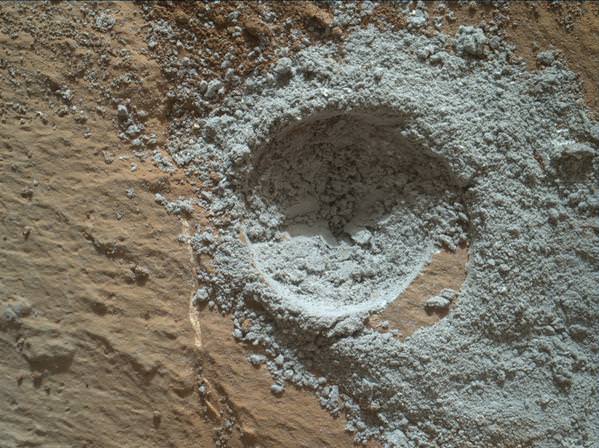
An initial test bore operation was conducted first to confirm whether that it was indeed safe to drill into “Buckskin” and cause no harm to the rover before committing to the entire operation.
The bore hole is about 1.6 cm (0.63 inch) in diameter.
“This test will drill a small hole in the rock to help determine whether it is safe to go ahead with the full hole,” elaborated Ryan Anderson, planetary scientist at the USGS Astrogeology Science Center and an MSL science team member.
So it was only after the team received back new high resolution imagery last night from the arm-mounted MAHLI camera which confirmed the success of the mini-drill operation, that the “GO” was given for a full depth drill campaign. MAHLI is short for Mars Hand Lens Imager.
“We successfully completed a mini drilling test yesterday (shown in the MAHLI image). That means that today we’re going for the FULL drill hole” Edgar confirmed.
“GO for Drilling.”
So it’s a busy day ahead on the Red Planet, including lots of imaging along the way to document and confirm that the drilling operation proceeds safely and as planned.
“First we’ll acquire MAHLI images of the intended drill site, then we’ll drill, and then we’ll acquire more MAHLI images after drilling,” Edgar explains.
“The plan also includes Navcam imaging of the workspace, and Mastcam imaging of the target and drill bit. In addition to drilling, we’re getting CheMin ready to receive sample in an upcoming plan. Fingers crossed!” Surface observations with the arm-mounted Alpha Particle X-ray Spectrometer (APXS) instrument are also planned.
If all goes well, the robot will process and pulverize the samples for eventual delivery to the onboard pair of miniaturized chemistry labs located inside her belly – SAM and CheMin. Tiny samples will be fed to the inlet ports on the rover deck through the sieved filters.
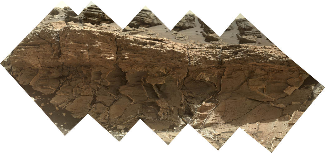
A rock outcrop dubbed “Missoula,” near Marias Pass on Mars, is seen in this image mosaic taken by the Mars Hand Lens Imager on NASA’s Curiosity rover. Pale mudstone (bottom of outcrop) meets coarser sandstone (top) in this geological contact zone, which has piqued the interest of Mars scientists. Credit: NASA/JPL-Caltech/MSSS
Meanwhile the team is studying a nearby rock outcrop called “Ch-paa-qn” which means “shining peak” in the native Salish language of northern Montana.”
Anderson says the target is a bright patch on a nearby outcrop. Via active and passive observations with the mast-mounted ChemCam laser and Mastcam multispectral imager, the purpose is to determine if “Ch-paa-qn” is comprised of calcium sulfate like other white veins visible nearby, or perhaps it’s something else entirely.
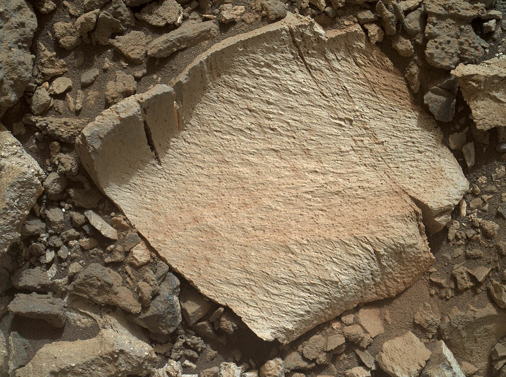
A rock fragment dubbed “Lamoose” is shown in this picture taken by the Mars Hand Lens Imager (MAHLI) on NASA’s Curiosity rover. Like other nearby rocks in a portion of the “Marias Pass” area of Mt. Sharp, Mars, it has unusually high concentrations of silica. The high silica was first detected in the area by the Chemistry & Camera (ChemCam) laser spectrometer. This rock was targeted for follow-up study by the MAHLI and the arm-mounted Alpha Particle X-ray Spectrometer (APXS). Credits: NASA/JPL-Caltech/MSSS
Before arriving by the “Lion” outcrop last week, Curiosity was investigating another outcrop area nearby, the high-silica target dubbed “Elk” with the ChemCam instrument, while scouting around the “Marias Pass” area in search of tasty science targets for in-depth analysis.
Sometimes the data subsequently returned and analyzed is so extraordinary, that the team decides on a return trip to a spot previously departed. Such was the case with “Elk” and the rover was commanded to do a U-turn to acquire more precious data.
“One never knows what to expect on Mars, but the Elk target was interesting enough to go back and investigate,” said Roger Wiens, the principal investigator of the ChemCam instrument from the Los Alamos National Laboratory in New Mexico.
Soon, ChemCam will have fired on its 1,000th target. Overall the laser blaster has been fired more than 260,000 times since Curiosity landed inside the nearly 100 mile wide Gale Crater on Mars on Aug. 6, 2012, alongside Mount Sharp.
“ChemCam acts like eyes and ears of the rover for nearby objects,” said Wiens.
“Marias Pass” is a geological context zone where two rock types overlap – pale mudstone meets darker sandstone.
The rover spotted a very curious outcrop named “Missoula.”
“We found an outcrop named Missoula where the two rock types came together, but it was quite small and close to the ground. We used the robotic arm to capture a dog’s-eye view with the MAHLI camera, getting our nose right in there,” said Ashwin Vasavada, the mission’s project scientist at NASA’s Jet Propulsion Laboratory in Pasadena, California.
White mineral veins, possibly comprised of calcium sulfate, filled the fractures by depositing the mineral from running groundwater.
“Such clues help scientists understand the possible timing of geological events,” says the team.
Read more about Curiosity in an Italian language version of this story at Alive Universe Images – here.
NASA’s Martian Curiosity rover looks backs to 1000 Sols of science and exploration on the surface of the Red Planet. Robot wheel tracks lead back through valley dunes. Gale Crater rim seen in the distant hazy background. Sol 997 (May 28, 2015) navcam camera raw images stitched and colorized. Credit: NASA/JPL-Caltech/ Marco Di Lorenzo/Ken Kremer/kenkremer.com Featured on APOD on June 13, 2015
As of today, Sol 1060, July 31, 2015, she has taken over 255,000 amazing images.
Red Mars, Gray Mars: “Mini-start hole” drill maneuver was successful. Image of mini start drill hole taken by Mars Hand Lens Imager (MAHLI) aboard NASA’s Mars rover Curiosity on July 30, 2015, Sol 1059. Credit: NASA/JPL-Caltech/MSSSCuriosity extends robotic arm and conducts test drill at “Buckskin” rock target at bright toned “Lion” outcrop on the lower region of Mount Sharp on Mars, seen at right. Gale crater rim seen in the distant background at left, in this composite mosaic of navcam raw images taken to Sol 1059, July 30, 2015. Navcam camera raw images stitched. Credit: NASA/JPL-Caltech/Ken Kremer/kenkremer.com/Marco Di Lorenzo
We’ve found hundreds of exoplanets in the galaxy. But only a few of them have just the right combination of factors to hold life like Earth’s.
The weather in your hometown is downright uninhabitable. There’s scorching heatwaves, annual tyhpoonic deluges, and snow deep enough to bury a corn silo.
The bad news is planet Earth is the only habitable place we know of in the entire Universe. Also, are the Niburians suffering from Niburian made climate change? Only Niburian Al Gore can answer that question.
We as a species are interested in habitability for an assortment of reasons, political, financial, humanitarian and scientific. We want to understand how our own climate is changing. How we’ll live in the climate of the future and what we can do to stem the tide of what our carbon consumption causes.
There could be agendas to push for cleaner energy sources, or driving politicians towards climate change denial to maintain nefarious financial gain.
We also might need a new lilypad to jump to, assuming we can sort out the travel obstacles. The thing that interests me personally the most is, when can I see an alien?
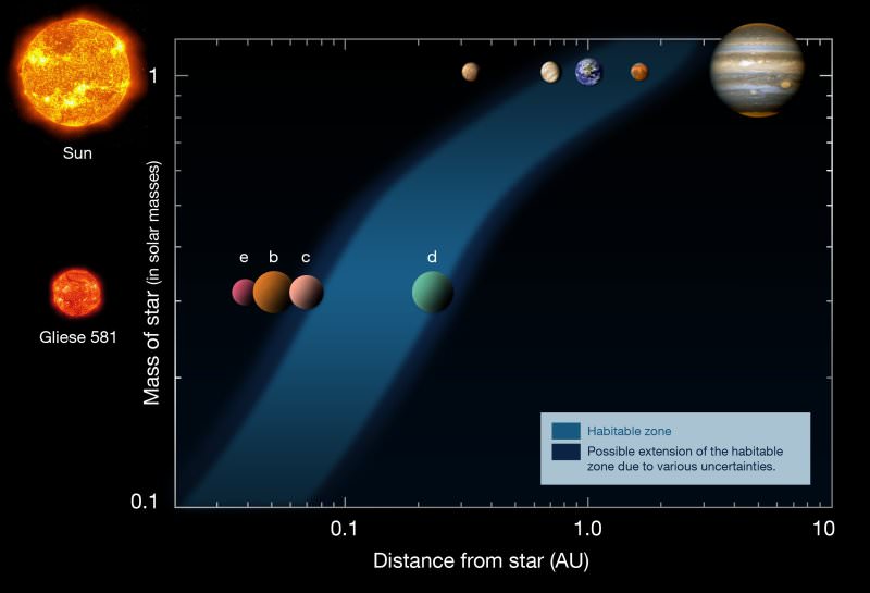
The habitable zone, also known as the “Goldilocks Zone”, is the region around a star where the average temperature on a planet allows for liquid water with which to make porridge. It’s that liquid water that we hunt for not only for our future uses, but as an indicator of where alien life could be in the Universe.
Problems outside this range are pretty obvious. Too hot, it’s a perpetual steam bath, or it produces separate piles of hydrogen and oxygen. Then your oxygen combines with carbon to form carbon dioxide, and then hydrogen just buggers off into space.
This is what happened with Venus. If the planet’s too cold, then bodies of water are solid skating rinks. There could be pockets of liquid water deep beneath the icy surface, but overall, they’re bad places to live.
We’ve got this on Mars and the moons of Jupiter and Saturn. The habitable zone is a rough measurement. It’s a place where liquid water might exist.
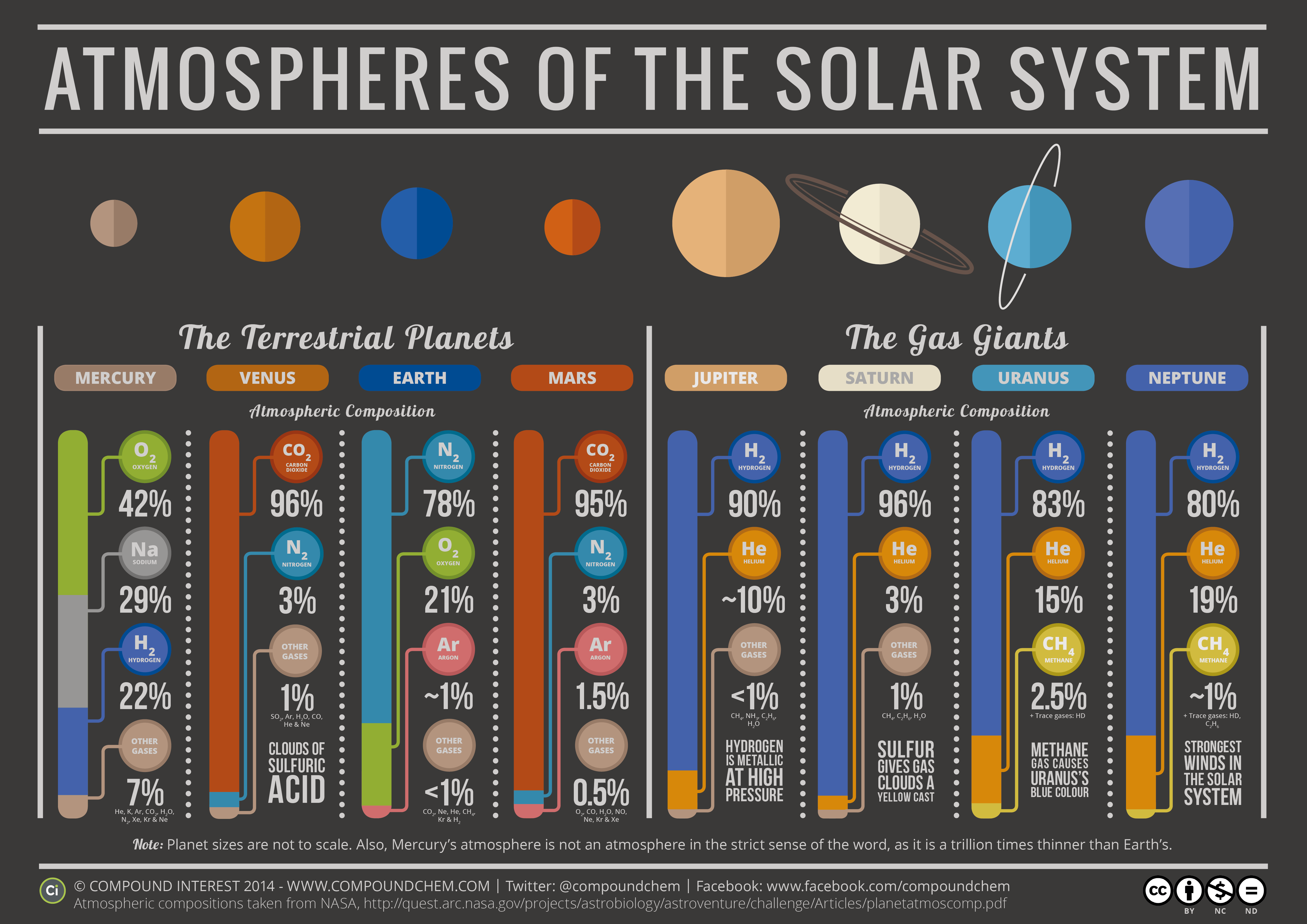
“The Chemistry of the Solar System” by Compound Interest’s Andy Brunning
Unfortunately, it’s not just a simple equation of the distance to the star versus the amount of energy output. The atmosphere of the planet matters a lot. In fact, both Venus and Mars are considered to be within the Solar System’s habitable zone.
Venusian atmosphere is so thick with carbon dioxide that it traps energy from the Sun and creates an inhospitable oven of heat that would quickboil any life faster than you can say “pass the garlic butter”.
It’s the opposite on Mars. The thin atmosphere won’t trap any heat at all, so the planet is bun-chillingly cold. Upgrade the atmospheres of either planet and you could get worlds which would be perfectly reasonable to live on. Maybe if we could bash them together and we could spill the atmosphere of one onto the other? Tell Blackbolt to ring up Franklin Richards, I have an idea!
When we look at other worlds in the Milky Way and wonder if they have life, it’s not enough to just check to see if they’re in the habitable zone. We need to know what shape their atmosphere is in.
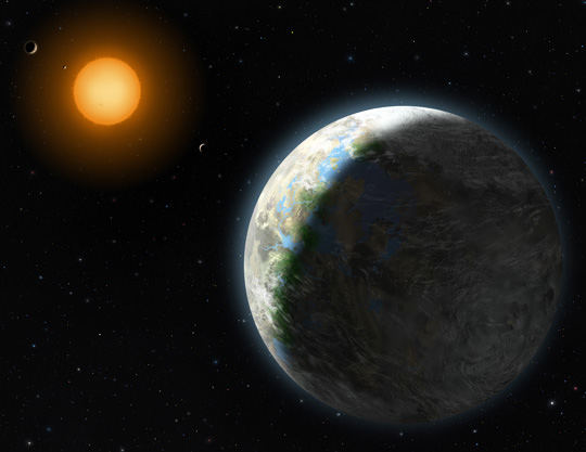
Astronomers have actually discovered planets located in the habitable zones around other stars, but from what we can tell, they’re probably not places you’d want to live. They’re all orbiting red dwarf stars.
Artists impression of Gliese 581g. Credit: Lynette Cook/NSF
It doesn’t sound too bad to live in a red tinted landscape, provided it came with an Angelo Badalamenti soundtrack, red dwarf stars are extremely violent in their youth. They blast out enormous solar flares and coronal mass ejections. These would scour the surface of any planets caught orbiting them close enough for liquid water to be present.
There is some hope. After a few hundred million years of high activity, these red dwarf stars settle down and sip away at their fuel reserves of hydrogen for potentially trillions of years. If life can hold on long enough to get through the early stages, it might have a long existence ahead of it.
When you’re thinking about a new home among the stars, or trying to seek out new life in the Universe, look for planets in the habitable zone.
As we’ve seen, it’s only a rough guideline. You probably want to check out the place first and make sure it’s truly liveable before you commit to a timeshare condo around Gliese 581.
Do you think habitable planets are common in the Milky Way? Tell us what your perfect planet environment might be in the comments below.
Artist's illustration of a SpaceX Starship lands on Mars. Credit: SpaceX
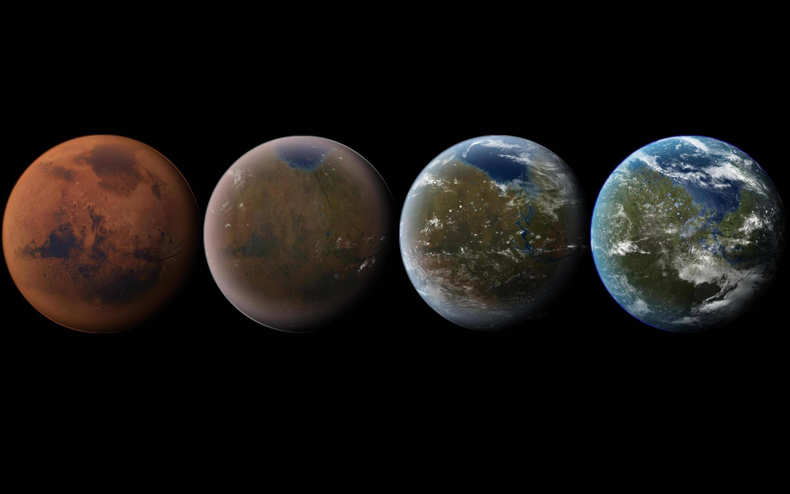
Welcome back to our series on Settling the Solar System! Today, we take a look at that cold and dry world known as “Earth’s Twin”. I’m talking about Mars. Enjoy!
Mars. It’s a pretty unforgiving place. On this dry, desiccated world, the average surface temperature is -55 °C (-67 °F). And at the poles, temperatures can reach as low as -153 °C (243 °F). Much of that has to do with its thin atmosphere, which is too thin to retain heat (not to mention breathe). So why then is the idea of colonizing Mars so intriguing to us?
Well, there are a number of reasons, which include the similarities between our two planets, the availability of water, the prospects for generating food, oxygen, and building materials on-site. And there are even long-term benefits to using Mars as a source of raw materials and terraforming it into a liveable environment. Let’s go over them one by one…
Examples in Fiction:
The idea of exploring and settling Mars has been explored in fiction for over a century. Most of the earliest depiction of Mars in fiction involved a planet with canals, vegetation, and indigenous life – owing to the observations of the astronomers like Giovanni Schiaparelli and Percival Lowell.
However, by the latter half of the 20th century (thanks in large part to the Mariner 4 missions and scientists learning of the true conditions on Mars) fictional accounts moved away from the idea of a Martian civilization and began to deal with humans eventually colonizing and transforming the environment to suit their needs.
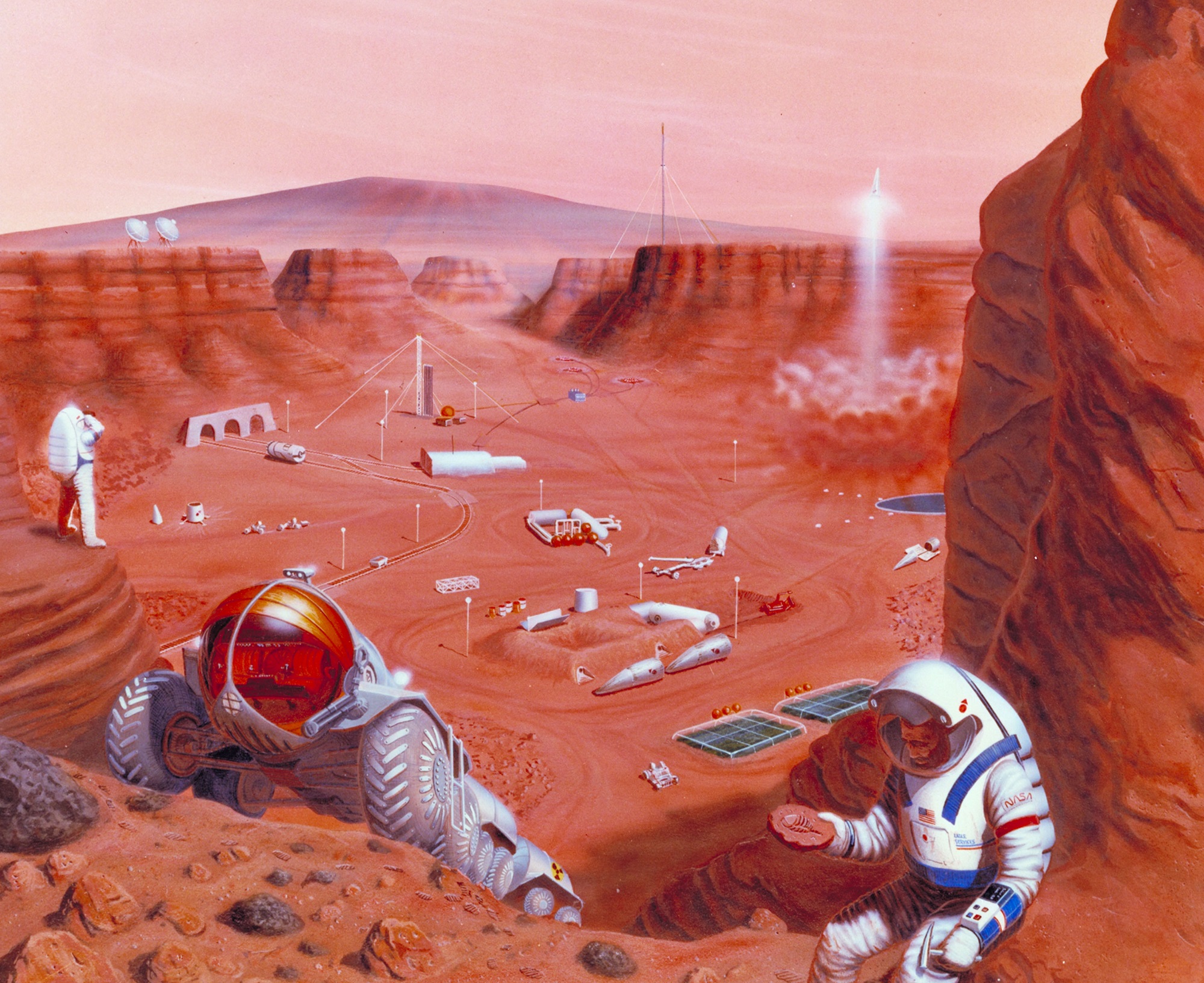
Artist impression of a Mars settlement with cutaway view. Credit: NASA Ames Research Center
This shift is perhaps best illustrated by Ray Bradbury’s The Martian Chronicles(published in 1950). A series of short stories that take place predominantly on Mars, the collection begins with stories about a Martian civilization that begins to encounter human explorers. The stories then transition to ones that deal with human settlements on the planet, the genocide of the Martians, and Earth eventually experiencing nuclear war.
During the 1950s, many classic science fiction authors wrote about colonizing Mars. These included Arthur C. Clarke and his 1951 story The Sands of Mars, which is told from the point of view of a human reporter who travels to Mars to write about human colonists. While attempting to make a life for themselves on a desert planet, they discover that Mars has native life forms.
In 1952, Isaac Asimov released The Martian Way, a story that deals with the conflict between Earth and Mars colonists. The latter manage to survive by salvaging space junk and are forced to travel to Saturn to harvest ice when Earth enforces an embargo on their planet.
Robert A. Heinlein’s seminal novel Stranger in a Strange Land (1961) tells the story of a human who was raised on Mars by the native Martians and then travels to Earth as a young adult. His contact with humans proves to have a profound effect on Earth’s culture, and calls into questions many of the social mores and accepted norms of Heinlein’s time.
Artist’s concept of possible exploration of the surface of Mars. Credit: NASA Ames Research Center
Philip K. Dick’s fiction also features Mars often, in every case being a dry, empty land with no native inhabitants. In his works Martian Time Slip (1964), and The Three Stigmata of Palmer Eldritch (1965), life on Mars is presented as difficult, consisting of isolated communities who do not want to live there.
In Do Androids Dream of Electric Sheep? (1968), most of humanity has left Earth after a nuclear war and now live in “the colonies” on Mars. Androids (Replicants) escaping illegally to come back to Earth claim that they have left because “nobody should have to live there. It wasn’t conceived for habitation, at least not within the last billion years. It’s so old. You feel it in the stones, the terrible old age”.
Kim Stanley Robinson’s Mars trilogy (published between 1992–1996), Mars is colonized and then terraformed over the course of many centuries. Ben Bova’s Grand Tour series – which deals with the colonization of the Solar System – also includes a novel titled Mars(1992). In this novel, explorers travel to Mars – locations including Mt. Olympus and Valles Marineris – to determine is Mars is worth colonizing.
Alastair Reynolds’ short story “The Great Wall of Mars” (2000) takes place in a future where the most technologically advanced humans are based on Mars and embroiled in an interplanetary war with a faction that takes issue with their experiments in human neurology.
Artist’s impression of the terraforming of Mars, from its current state to a livable world. Credit: Daein Ballard
In Hannu Rajaniemi’s The Quantum Thief (2010), we get a glimpse of Mars in the far future. The story centers on the city of Oubliette, which moves across the face of the planet. Andry Weir’s The Martian (2011) takes place in the near future, where an astronaut is stranded on Mars and forced to survive until a rescue party arrives.
Kim Stanley Robinson’s 2312(2012) takes place in a future where humanity has colonized much of the Solar System. Mars is mentioned in the course of the story as a world that has been settled and terraformed (which involved lasers cutting canals similar to what Schiaparelli described) and now has oceans covering much of its surface.
Proposed Methods:
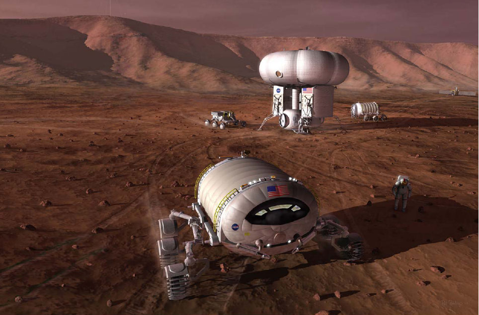
NASA’s proposed manned mission to Mars – which is slated to take place during the 2030s using the Orion Multi-Purpose Crew Vehicle (MPCV) and the Space Launch System (SLS) – is not the only proposal to send humans to the Red Planet. In addition to other federal space agencies, there are also plans by private corporations and non-profits, some of which are far more ambitious than mere exploration.
The European Space Agency (ESA) has long-term plans to send humans, though they have yet to build a manned spacecraft. Roscosmos, the Russian Federal Space Agency, is also planning a manned Mars mission, with simulations (called Mars-500) having been completed in Russia back in 2011. The ESA is currently participating in these simulations as well.
In 2012, a group of Dutch entrepreneurs revealed plans for a crowdfunded campaign to establish a human Mars base, beginning in 2023. Known as Mars One, the plan calls for a series of one-way missions to establish a permanent and expanding colony on Mars, which would be financed with the help of media participation.
Mars-manned-mission vehicle (NASA Human Exploration of Mars Design Reference Architecture 5.0) Feb 2009. Credit: NASA
Other details of the MarsOne plan include sending a telecom orbiter by 2018, a rover in 2020, and the base components and its settlers by 2023. The base would be powered by 3,000 square meters of solar panels, and the SpaceX Falcon 9 Heavy rocket would be used to launch the hardware. The first crew of 4 astronauts would land on Mars in 2025; then, every two years, a new crew of 4 astronauts would arrive.
On December 2nd, 2014, NASA’s Advanced Human Exploration Systems and Operations Mission Director Jason Crusan and Deputy Associate Administrator for Programs James Reuther announced tentative support for the Boeing “Affordable Mars Mission Design.” Currently planned for the 2030s, the mission profile includes plans for radiation shielding, centrifugal artificial gravity, in-transit consumable resupply, and a return-lander.
SpaceX and Tesla CEO Elon Musk also announced plans to establish a colony on Mars with a population of 80,000 people. Intrinsic to this plan is the development of the Mars Colonial Transporter (MCT), a spaceflight system that would rely on reusable rocket engines, launch vehicles, and space capsules to transport humans to Mars and return to Earth.
As of 2014, SpaceX has begun developing the large Raptor rocket engine for the Mars Colonial Transporter, and a successful test was announced in September of 2016. In January 2015, Musk said that he hoped to release details of the “completely new architecture” for the Mars transport system in late 2015.
In June 2016, Musk stated in the first unmanned flight of the Mars transport spacecraft would take place in 2022, followed by the first manned MCT Mars flight departing in 2024. In September 2016, during the 2016 International Astronautical Congress, Musk revealed further details of his plan, which included the design for an Interplanetary Transport System (ITS) and estimated costs.
There may come a day when, after generations of terraforming and numerous waves of colonists, that Mars will begin to have a viable economy as well. This could take the form of mineral deposits being discovered and then sent back to Earth for sale. Launching precious metals, like platinum, off the surface of Mars would be relatively inexpensive thanks to its lower gravity.
But according to Musk, the most likely scenario (at least for the foreseeable future) would involve an economy based on real estate. With human populations exploding all over Earth, a new destination that offers plenty of room to expand is going to look like a good investment.
And once transportation issues are worked out, savvy investors are likely to start buying up land. Plus, there is likely to be a market for scientific research on Mars for centuries to come. Who knows what we might find once planetary surveys really start to open up!
Over time, many or all of the difficulties in living on Mars could be overcome through the application of geoengineering (aka. terraforming). Using organisms like cyanobacteria and phytoplankton, colonists could gradually convert much of the CO² in the atmosphere into breathable oxygen.
In addition, it is estimated that there is a significant amount of carbon dioxide (CO²) in the form of dry ice at the Martian south pole, not to mention absorbed by in the planet’s regolith (soil). If the temperature of the planet were raised, this ice would sublimate into gas and increase atmospheric pressure. Although it would still not be breathable by humans, it would be sufficient enough to eliminate the need for pressure suits.
A possible way of doing this is by deliberately triggering a greenhouse effect on the planet. This could be done by importing ammonia ice from the atmospheres of other planets in our Solar System. Because ammonia (NH³) is mostly nitrogen by weight, it could also supply the buffer gas needed for a breathable atmosphere – much as it does here on Earth.
Similarly, it would be possible to trigger a greenhouse effect by importing hydrocarbons like methane – which is common in Titan’s atmosphere and on its surface. This methane could be vented into the atmosphere where it would act to compound the greenhouse effect.
Zubrin and Chris McKay, an astrobiologist with NASA’s Ames Research center, have also suggested creating facilities on the surface that could pump greenhouse gases into the atmosphere, thus triggering global warming (much as they do here on Earth).
Other possibilities exist as well, ranging from orbital mirrors that would heat the surface to deliberately impacting the surface with comets. But regardless of the method, possibilities exist for transforming Mars’ environment that could make it more suitable for humans in the long run – many of which we are currently doing right here on Earth (with less positive results).
Another proposed solution is building habitats underground. By building a series of tunnels that connect between subterranean habitats, settlers could forgo the need for oxygen tanks and pressure suits when they are away from home.
Additionally, it would provide protection against radiation exposure. Based on data obtained by the Mars Reconnaissance Orbiter, it is also speculated that habitable environments exist underground, making it an even more attractive option.
Potential Benefits:
As already mentioned, there are many interesting similarities between Earth and Mars that make it a viable option for colonization. For starters, Mars and Earth have very similar lengths of days. A Martian day is 24 hours and 39 minutes, which means that plants and animals – not to mention human colonists – would find that familiar.
Diagram showing the habitable zones of the Solar System (upper row) and the Gliese 581 system (lower row). Based on a diagram by Franck Selsis, Univ. of Bordeaux. Credit: ESO
Mars also has an axial tilt that is very similar to Earth’s, which means it has the same basic seasonal patterns as our planet (albeit for longer periods of time). Basically, when one hemisphere is pointed towards the Sun, it experiences summer while the other experiences winter – complete with warmer temperatures and longer days.
This too would work well when it comes to growing seasons and would provide colonists with a comforting sense of familiarity and a way of measuring out the year. Much like farmers here on Earth, native Martians would experience a “growing season”, a “harvest”, and would be able to hold annual festivities to mark the changing of the seasons.
Also, much like Earth, Mars exists within our Sun’s habitable zone (aka. “Goldilocks zone“), though it is slightly towards its outer edge. Venus is similarly located within this zone, but its location on the inner edge (combined with its thick atmosphere) has led to it becoming the hottest planet in the Solar System. That, combined with its sulfuric acid rains makes Mars a much more attractive option.
Additionally, Mars is closer to Earth than the other Solar planets – except for Venus, but we already covered why it’s not a very good option! This would make the process of colonizing it easier. In fact, every few years when the Earth and Mars are at opposition – i.e. when they are closest to each other – the distance varies, making certain “launch windows” ideal for sending colonists.
For example, on April 8th, 2014, Earth and Mars were 92.4 million km (57.4 million miles) apart at opposition. On May 22nd, 2016, they will be 75.3 million km (46.8 million miles) apart, and by July 27th of 2018, a meager 57.6 million km (35.8 million miles) will separate our two worlds. During these windows, getting to Mars would be a matter of months rather than years.
Also, Mars has vast reserves of water in the form of ice. Most of this water ice is located in the polar regions, but surveys of Martian meteorites have suggested that much of it may also be locked away beneath the surface. This water could be extracted and purified for human consumption easily enough.
In his book, The Case for Mars, Robert Zubrin also explains how future human colonists might be able to live off the land when traveling to Mars, and eventually colonize it. Instead of bringing all their supplies from Earth – like the inhabitants of the International Space Station – future colonists would be able to make their own air, water, and even fuel by splitting Martian water into oxygen and hydrogen.
New estimates of water ice on Mars suggest there may be large reservoirs of underground ice at non-polar latitudes. Credit: Feldman et al., 2011
Preliminary experiments have shown that Mars soil could be baked into bricks to create protective structures, which would reduce the amount of material that needs to be shipped to the surface. Earth plants could eventually be grown in Martian soil too, assuming they get enough sunlight and carbon dioxide. Over time, planting on the native soil could also help to create a breathable atmosphere.
Challenges:
Despite the aforementioned benefits, there are also some rather monumental challenges to colonizing the Red Planet. For starters, there is the matter of the average surface temperature, which is anything but hospitable. While temperatures around the equator at midday can reach a balmy 20 °C, at the Curiosity site – the Gale Crater, which is close to the equator – typical nighttime temperatures are as low as -70 °C.
The gravity on Mars is also only about 40% of what we experience on Earth’s, which would make adjusting to it quite difficult. According to a NASA report, the effects of zero-gravity on the human body are quite profound, with a loss of up to 5% muscle mass a week and 1% of bone density a month.
Naturally, these losses would be lower on the surface of Mars, where there is at least some gravity. But permanent settlers would still have to contend with the problems of muscle degeneration and osteoporosis in the long run.
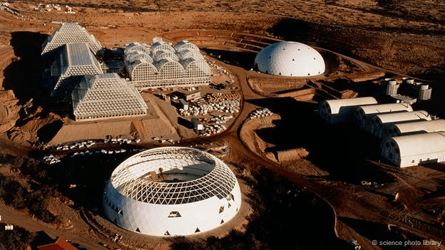
The Biosphere 2 project is an attempt to simulate Mars-like conditions on Earth. Credit: Science Photo Library
And then there’s the atmosphere, which is unbreathable. About 95% of the planet’s atmosphere is carbon dioxide, which means that in addition to producing breathable air for their habitats, settlers would also not be able to go outside without a pressure suit and bottled oxygen.
Mars also has no global magnetic field comparable to Earth’s geomagnetic field. Combined with a thin atmosphere, this means that a significant amount of ionizing radiation is able to reach the Martian surface.
Thanks to measurements taken by the Mars Odyssey spacecraft’s Mars Radiation Environment Experiment (MARIE), scientists learned that radiation levels in orbit above Mars are 2.5 times higher than at the International Space Station. Levels on the surface would be lower, but would still be higher than human beings are accustomed to.
In fact, a recent paper submitted by a group of MIT researchers – which analyzed the Mars One plan to colonize the planet beginning in 2020 – concluded that the first astronaut would suffocate after 68 days, while the others would die from a combination of starvation, dehydration, or incineration in an oxygen-rich atmosphere.
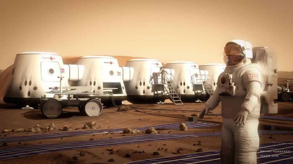
Artist’s concept of a Martian astronaut standing outside the Mars One habitat. Credit: Bryan Versteeg/Mars One
In short, the challenges to creating a permanent settlement on Mars are numerous, but not necessarily insurmountable. And if we do decide, as individuals and as a species, that Mars is to become a second home for humanity, we will no doubt find creative ways to address them all.
Who knows? Someday, perhaps even within our own lifetimes, there could be real Martians. And they would be us!
Universe Today has many interesting articles about the possibility of humans living on Mars. Here’s a great article by Nancy Atkinson about the possibility of a one-way, one-person trip to Mars
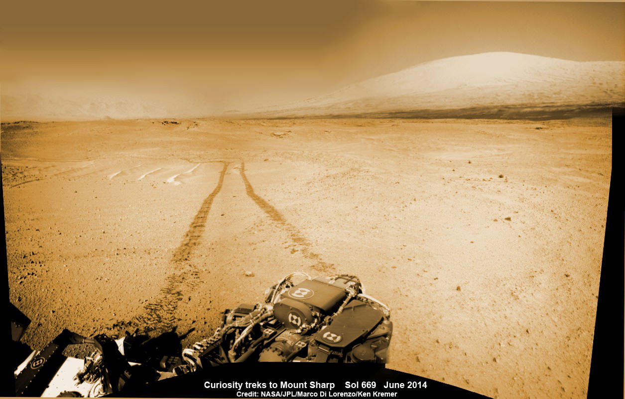
1 Martian Year on Mars! Curiosity treks to Mount Sharp in this photo mosaic view captured on Sol 669, June 24, 2014. Navcam camera raw images stitched and colorized. Credit: NASA/JPL-Caltech/Marco Di Lorenzo/Ken Kremer – kenkremer.com
2 Years on Mars!
Curiosity treks to Mount Sharp, her primary science destination, in this photo mosaic view captured on Sol 669, June 24, 2014. Navcam camera raw images stitched and colorized. Credit: NASA/JPL-Caltech/Marco Di Lorenzo/Ken Kremer – kenkremer.com
Story and mosaics updated[/caption]
NASA’s most scientifically powerful rover ever dispatched to the Red Planet, Curiosity, is celebrating her 2nd anniversary on Mars since the dramatic touchdown inside Gale Crater on Aug. 6, 2012, EDT (Aug. 5, 2012, PDT) while simultaneously approaching a bedrock unit that for the first time is actually part of the humongous mountain she will soon scale and is the primary science destination of the mission.
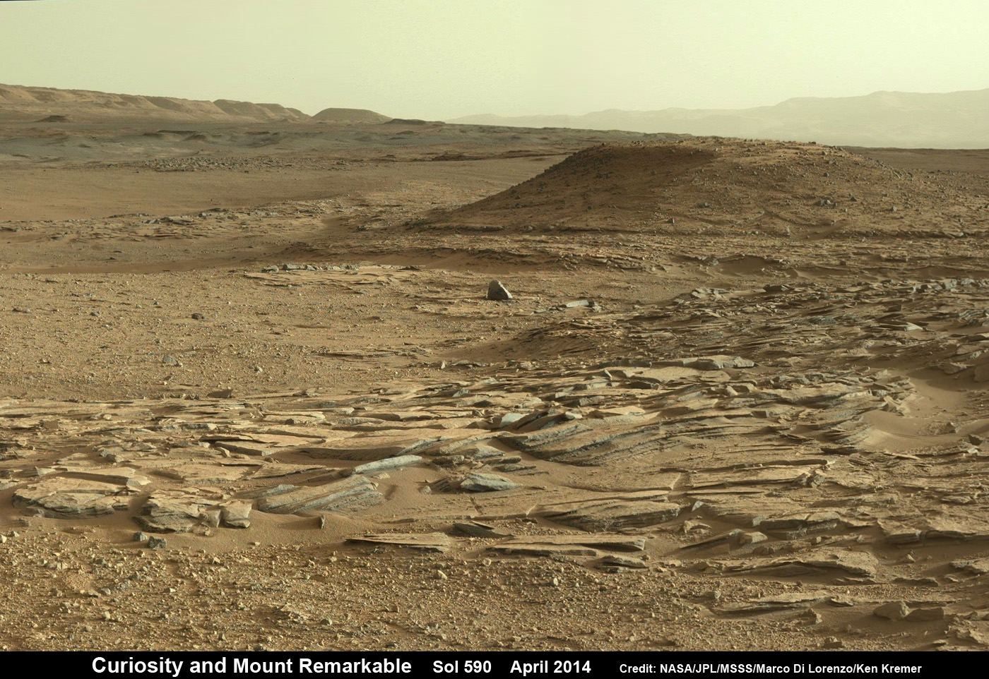
Mount Sharp is a layered mountain that dominates most of Gale Crater and towers 3.4 miles (5.5 kilometers) into the Martian sky and is taller than Mount Rainier.
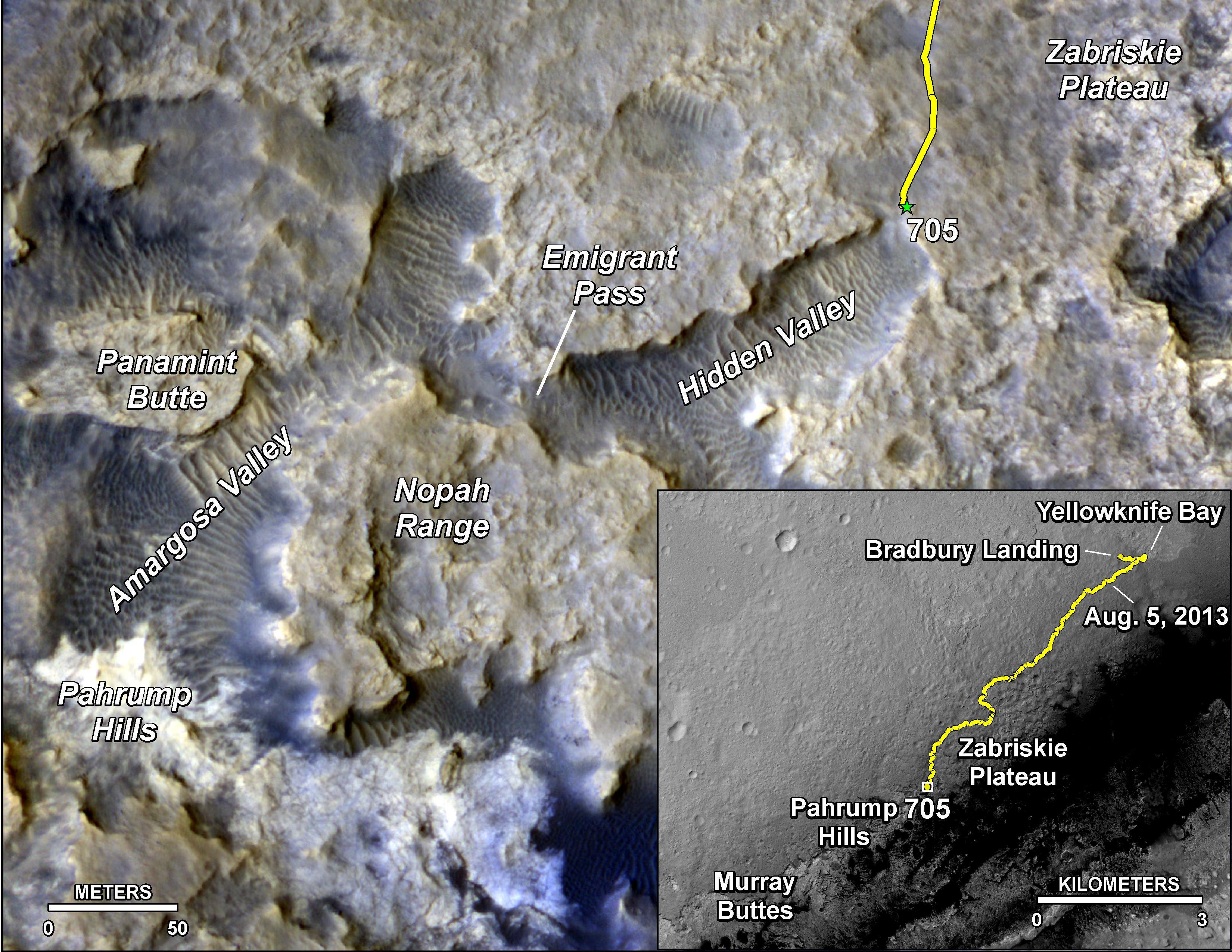
Aug. 6, 2014 marks ‘2 Years on Mars’ and Sol 711 for Curiosity in an area called “Hidden Valley.”
“Getting to Mount Sharp is the next big step for Curiosity and we expect that in the Fall of this year,” Dr. Jim Green, NASA’s Director of Planetary Sciences at NASA Headquarters, Washington, DC, told me in an interview making the 2nd anniversary.
The 1 ton rover is equipped with 10 state-of-the-art science instruments and searching for signs of life.
The mysterious mountain is so huge that outcrops of bedrock extend several miles out from its base and Curiosity is now within striking distance of reaching the area the rover team calls “Pahrump Hills.”
2 Earth Years on Mars!
NASA’s Curiosity rover celebrated the 2nd anniversary on Mars at ‘Hidden Valley’ as shown in this photo mosaic view captured on Aug. 6, 2014, Sol 711. Note the valley walls, rover tracks and distant crater rim. Navcam camera raw images stitched and colorized. Credit: NASA/JPL-Caltech/Ken Kremer-kenkremer.com/Marco Di Lorenzo
Scientists anticipate that the outcrops at “Pahrump Hills” offer a preview of a geological unit that is part of the base of Mount Sharp for the first time since landing rather than still belonging to the floor of Gale Crater.
“We’re coming to our first taste of a geological unit that’s part of the base of the mountain rather than the floor of the crater,” said Curiosity Project Scientist John Grotzinger of the California Institute of Technology, Pasadena, in a statement.
“We will cross a major terrain boundary.”
Since “Pahrump Hills” is less than one-third of a mile (500 meters) from Curiosity she should arrive soon.
In late July 2014, the rover arrived in an area of sandy terrain called “Hidden Valley” which is on the planned route ahead leading to “Pahrump Hills” and easily traversable with few of the sharp edged rocks that have caused significant damage to the rovers six aluminum wheels.
This full-circle panorama of the landscape surrounding NASA’s Curiosity Mars rover on July 31, 2014, Sol 705, offers a view into sandy lower terrain called “Hidden Valley,” which is on the planned route ahead. It combines several images from Curiosity’s Navigation Camera. South is at the center. Credit: NASA/JPL-Caltech
The sedimentary layers in the lower slopes of Mount Sharp have been Curiosity’s long-term science destination.
They are the principal reason why the science team specifically chose Gale Crater as the primary landing site based on high resolution spectral observations collected by NASA’s powerful Mars Reconnaissance Orbiter (MRO) indicating the presence of deposits of clay-bearing sedimentary rocks.
Curiosity’s goal all along has been to determine whether Mars ever offered environmental conditions favorable for microbial life. Finding clay bearing minerals. or phyllosilicates, in Martian rocks is the key to fulfilling its major objective.
The team expected to find the clay bearing minerals only in the sedimentary layers at the lower reaches of Mount Sharp.
Curiosity rover panorama of Mount Sharp captured on June 6, 2014 (Sol 651) during traverse inside Gale Crater. Note rover wheel tracks at left. She will eventually ascend the mountain at the ‘Murray Buttes’ at right later this year. Assembled from Mastcam color camera raw images and stitched by Marco Di Lorenzo and Ken Kremer. Credit: NASA/JPL/MSSS/Marco Di Lorenzo/Ken Kremer-kenkremer.com
Soon after landing, the team spotted some rather interesting looking outcrops barely a half mile away from the touchdown zone at a spot dubbed ‘Yellowknife Bay” and decided to take a detour towards it to investigate.
Well the scientists won the bet and struck scientific gold barely six months after landing when they drilled into a rock outcrop named “John Klein” at “Yellowknife Bay” and unexpectedly discovered the clay bearing minerals on the crater floor.
Yellowknife Bay was found to be an ancient lakebed where liquid water flowed on Mars surface billions of years ago.
The discovery of phyllosilicates in the 1st drill sample during the spring of 2013 meant that Curiosity had rather remarkably already fulfilled its primary goal of finding a habitable zone during its first year of operations!
The rock analysis “yielded evidence of a lakebed environment billions of years ago that offered fresh water, all of the key elemental ingredients for life, and a chemical source of energy for microbes, if any existed there,” according to NASA.
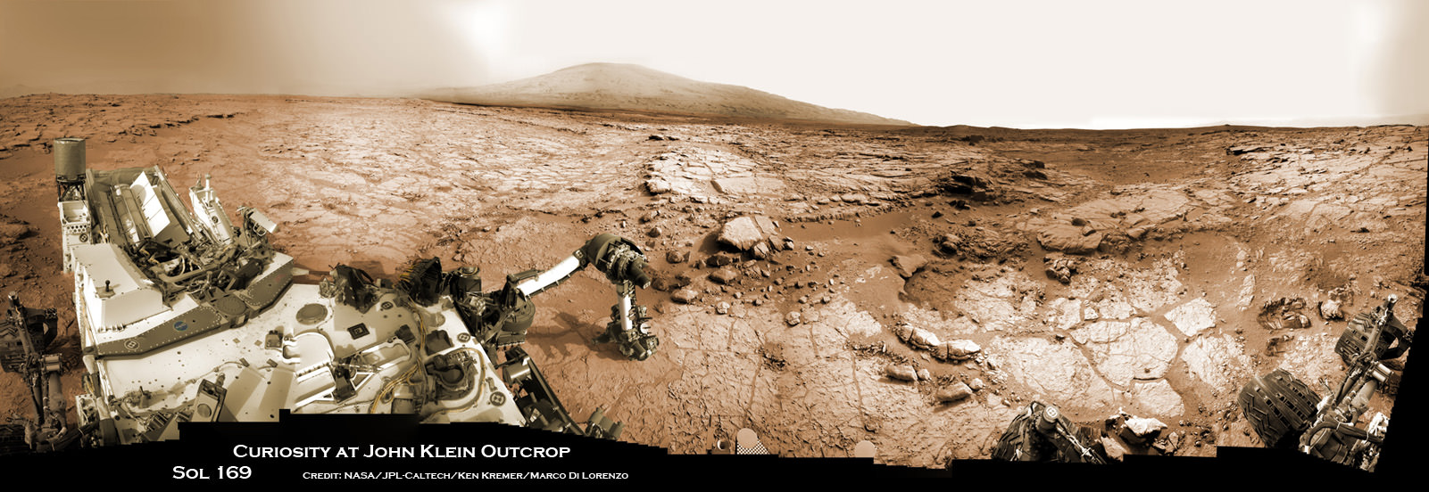
Curiosity accomplished Historic 1st drilling into Martian rock at John Klein outcrop on Feb 8, 2013 (Sol 182) and discovered a habitable zone, shown in this context mosaic view of the Yellowknife Bay basin taken on Jan. 26 (Sol 169). The robotic arm is pressing down on the surface at John Klein outcrop of veined hydrated minerals – dramatically back dropped with her ultimate destination; Mount Sharp. Credit: NASA/JPL-Caltech/Ken Kremer-kenkremer.com/Marco Di Lorenzo
“Before landing, we expected that we would need to drive much farther before answering that habitability question,” said Curiosity Project Scientist John Grotzinger of the California Institute of Technology, Pasadena. “We were able to take advantage of landing very close to an ancient streambed and lake. Now we want to learn more about how environmental conditions on Mars evolved, and we know where to go to do that.”
During the rovers second Earth year on the Red Planet, Curiosity has been driving as fast as possible towards a safe entry point to the slopes of Mount Sharp. The desired destination for the car sized rover is now about 2 miles (3 kilometers) southwest of its current location.
‘Driving, Driving, Driving’ is indeed the rover teams mantra.
The main map here shows the assortment of landforms near the location of NASA’s Curiosity Mars rover as the rover’s second anniversary of landing on Mars nears. The gold traverse line entering from upper right ends at Curiosity’s position as of Sol 705 on Mars (July 31, 2014). The inset map shows the mission’s entire traverse from the landing on Aug. 5, 2012, PDT (Aug. 6, EDT) to Sol 705, and the remaining distance to long-term science destinations near Murray Buttes, at the base of Mount Sharp. The label “Aug. 5, 2013” indicates where Curiosity was one year after landing. Credit: NASA/JPL-Caltech/Univ. of Arizona
To date, Curiosity’s odometer totals over 5.5 miles (9.0 kilometers) since landing inside Gale Crater on Mars in August 2012. She has taken over 174,000 images.
Curiosity still has about another 2 miles (3 kilometers) to go to reach the entry way at a gap in the treacherous sand dunes at the foothills of Mount Sharp sometime later this year.
And NASA is moving forward with future Red Planet missions when it recently announced the selection of 7 instruments chosen to fly aboard the Mars 2020 rover, the agency’s next rover going to Mars that will search for signs of ancient life as well as carry a technology demonstration that will help pave the way for ‘Humans to Mars’ in the 2030s. Read my story – here.
Coincidentally, ESA’s Rosetta comet hunting spacecraft arrived in orbit at its destination Comet 67P after a 10 year voyage on the same day as Curiosity’s 2 Earth year anniversary.
Stay tuned here for Ken’s continuing Rosetta, Curiosity, Opportunity, Orion, SpaceX, Boeing, Orbital Sciences, commercial space, MAVEN, MOM, Mars and more planetary and human spaceflight news.
Up close view of hole in one of rover Curiosity’s six wheels caused by recent driving over rough Martian rocks. Mosaic assembled from Mastcam raw images taken on Dec. 22, 2013 (Sol 490). Credit: NASA/JPL/MSSS/Ken Kremer – kenkremer.com/Marco Di Lorenzo
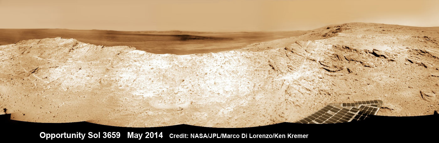
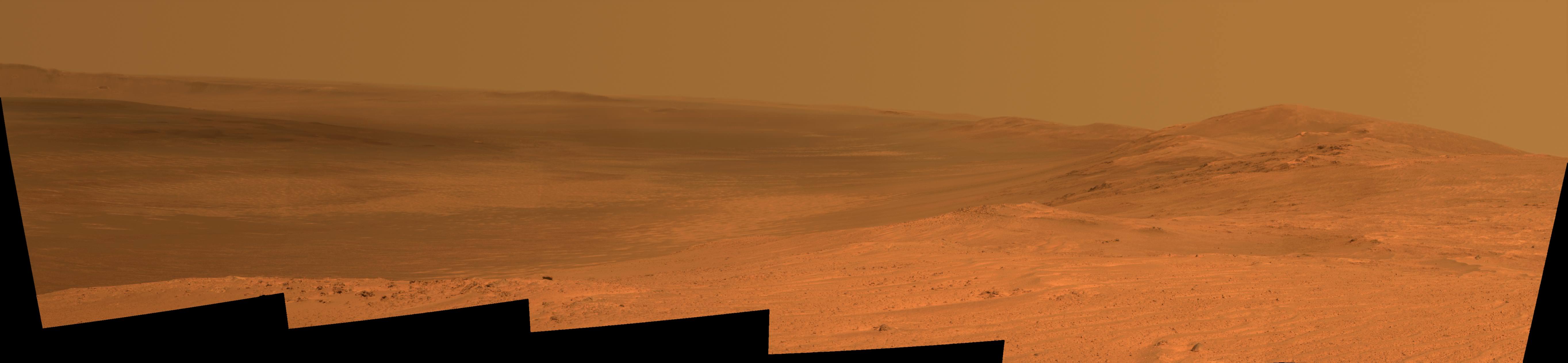
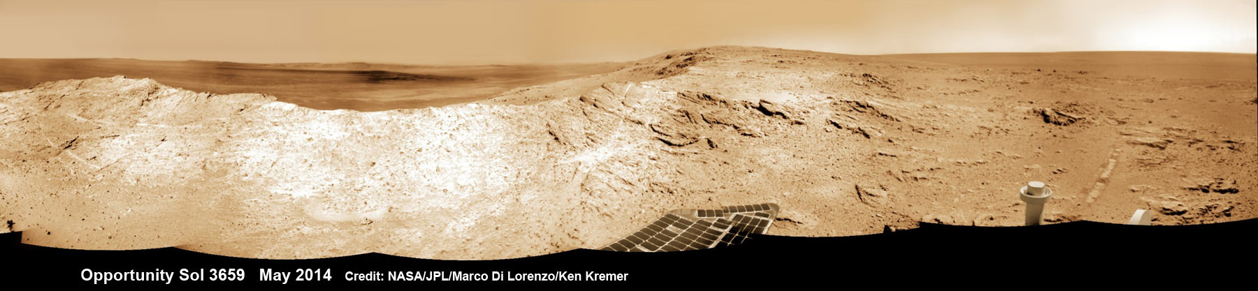
NASA’s Opportunity Mars rover captures sweeping panoramic vista near the ridgeline of 22 km (14 mi) wide Endeavour Crater’s western rim. The center is southeastward and also clearly shows the distant rim. See the complete panorama below. This navcam panorama was stitched from images taken on May 10, 2014 (Sol 3659) and colorized. Credit: NASA/JPL/Cornell/Marco Di Lorenzo/Ken Kremer-kenkremer.com
NASA’s Opportunity Mars rover captures sweeping panoramic vista near the ridgeline of 22 km (14 mi) wide Endeavour Crater’s western rim. The center is southeastward and also clearly shows the distant rim. See the complete panorama below. This navcam panorama was stitched from images taken on May 10, 2014 (Sol 3659) and colorized. Credit: NASA/JPL/Cornell/Marco Di Lorenzo/Ken Kremer-kenkremer.com
More mosaics and 10 year route map below[/caption]
NASA’s incredibly long lived Opportunity rover has driven to the ridgeline of a Martian mountain and captured spectacular panoramic vistas peering down into the vast expanse of huge Endeavour crater and out along the jagged rim segments leading to her next target – which scientists believe holds minerals indicative of a habitable zone. See mosaic views above and below.
Since departing the world famous ‘Jelly Doughnut’ rock by the summit of ‘Solander Point’ in February, Opportunity has spent the past several months driving south and exploring intriguing rock outcrops on ‘Murray Ridge’ located along the eroded western rim of Endeavour Crater.
The renowned robot is now exploring a region of outcrops atop the rims ridge that’s a possible site harboring deposits of hydrated clay minerals, formed in the ancient past when Mars was warmer and wetter.
The ten year oldRed Planet rover first reached the rim of Endeavour Crater in August 2011. She has captured numerous sweeping gorgeous vistas during her first of its kind expedition on the surface of another planet by an alien probe from Earth.
Read my earlier story detailing the top 10 discoveries from twin sisters Spirit and Opportunity according to Deputy Principal Investigator Prof. Ray Arvidson – here.
The gigantic crater spans 14 miles (22 kilometers) in diameter.
So there is endless enthralling terrain to investigate – for at least another 10 years!
The floor of Endeavour crater is filled with dark sand, brighter dust, and, in the distance, dusty haze, says NASA.
This vista of the Endeavour Crater rim was acquired by NASA’s Mars Exploration Rover Opportunity’s panoramic camera on April 18, 2014, from the southern end of “Murray Ridge” on the western rim of the crater. In mid-May, the rover approached the dark outcrops on the flank of the hill at right. The high peak in the distance on the right is informally named “Cape Tribulation” and is about 1.2 miles (2 kilometers) to the south of Opportunity’s position when this view was recorded Credit: NASA/JPL-Caltech/Cornell Univ./Arizona State Univ.
Opportunity’s goal all the while has been to doggedly trek southwards towards exposures of aluminum-rich clays detected from orbit by NASA’s powerful Martian ‘Spysat’ – the Mars Reconnaissance Orbiter (MRO) – while gathering context data at rock outcrops at Murray Ridge along the winding way.
These aluminum-rich clay minerals, or phyllosilicates, likely formed billions of years ago in flowing liquid neutral water which is more conducive to life, compared to more acidic environments explored earlier in the mission, and is therefore potentially indicative of a Martian habitable zone and a scientific goldmine.
The science and engineering team has used the high resolution MRO spectral and imaging data to more efficiently direct Opportunity southwards along the Endeavour crater rim and towards the biggest caches of the clay minerals – which were detected at a mountainous rim segment called ‘Cape Tribulation’ and which is seen in the panoramic vistas.
Although Cape Tribulation still lies some 1.2 miles (2 kilometers) further south, the rover has just arrived at a region which the team believes shows the first signatures of the clay minerals.
NASA’s Opportunity Mars rover captures sweeping panoramic vista near the ridgeline of 22 km (14 mi) wide Endeavour Crater’s western rim. The center is southeastward and the distant rim is visible in the center. An outcrop area targeted for the rover to study is at right of ridge. This navcam panorama was stitched from images taken on May 10, 2014 (Sol 3659) and colorized. Credit: NASA/JPL/Cornell/Marco Di Lorenzo/Ken Kremer-kenkremer.com
“The rover is exploring the region of aluminum-hydroxyl clay minerals seen from orbit,” said NASA in a mission update.
The six wheeled robot will utilize her mast mounted cameras and arm mounted microscopic imager (MI) and APXS spectrometer to gather images and measurements to unlock the mysteries of Mars ability to support life – past or present.
“The more we explore Mars, the more interesting it becomes. These latest findings present yet another kind of gift that just happens to coincide with Opportunity’s 10th anniversary on Mars,” said Michael Meyer, lead scientist for NASA’s Mars Exploration Program.
“We’re finding more places where Mars reveals a warmer and wetter planet in its history. This gives us greater incentive to continue seeking evidence of past life on Mars.”
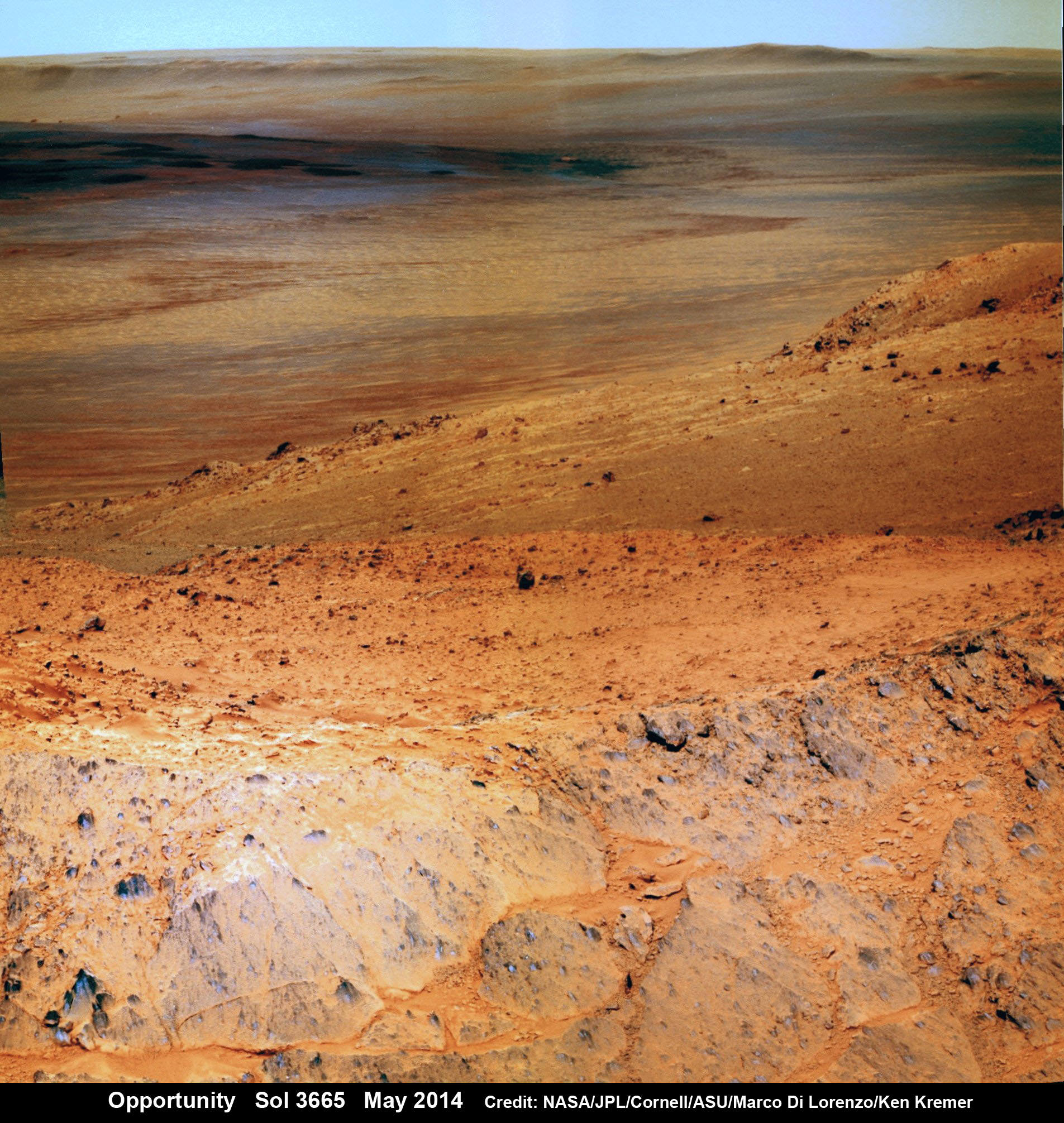
Opportunity Mars rover peers over mountain ridge for gorgeous vista into floor and out to distant rim of 22 km (14 mi) wide Endeavour Crater. This pancam camera view was assembled from images taken on May 16, 2014 (Sol 3665) with false color sky. Credit: NASA/JPL/Cornell/Marco Di Lorenzo/Ken Kremer-kenkremer.com
And Opportunity is now power-rich following a series of fortuitous wind cleaning events that substantially cleared the dust off the power generating solar wing arrays.
The solar array energy production has reached 761 watt-hours compared to about 900 watt-hours at landing in 2004 and only about 270 watt-hours just before Christmastime in December 2013.
“Solar panels [are] cleanest since about sol 1600 [September 2008],” says mission science team member Larry Crumpler.
More power means more work time and more bonus science studies and data return.
So the robot survived magnificently through her 6th harsh Martian winter with plenty of science rich targets planned ahead during the southern hemisphere Martian spring and summer.
Opportunity by Solander Point peak – 2nd Mars Decade Starts here!
NASA’s Opportunity rover captured this panoramic mosaic on Dec. 10, 2013 (Sol 3512) near the summit of “Solander Point” on the western rim of Endeavour Crater where she starts Decade 2 on the Red Planet. She is currently investigating outcrops of potential clay minerals formed in liquid water on her 1st mountain climbing adventure. Assembled from Sol 3512 navcam raw images. Credit: NASA/JPL/Cornell/Marco Di Lorenzo/Ken Kremer-kenkremer.com
Today, May 24, marks Opportunity’s 3673nd Sol or Martian Day roving Mars – compared to a warranty of just 90 Sols.
So far she has snapped over 192,600 amazing images on the first overland expedition across the Red Planet.
Her total odometry stands at over 24.49 miles (39.41 kilometers) since touchdown on Jan. 24, 2004 at Meridiani Planum.
Meanwhile on the opposite side of Mars, Opportunity’s younger sister rover Curiosity is trekking towards gigantic Mount Sharp and just drilled into her 3rd Red Planet rock at Kimberley.
Stay tuned here for Ken’s continuing Curiosity, Opportunity, Orion, SpaceX, Boeing, Orbital Sciences, MAVEN, MOM, Mars and more planetary and human spaceflight news.
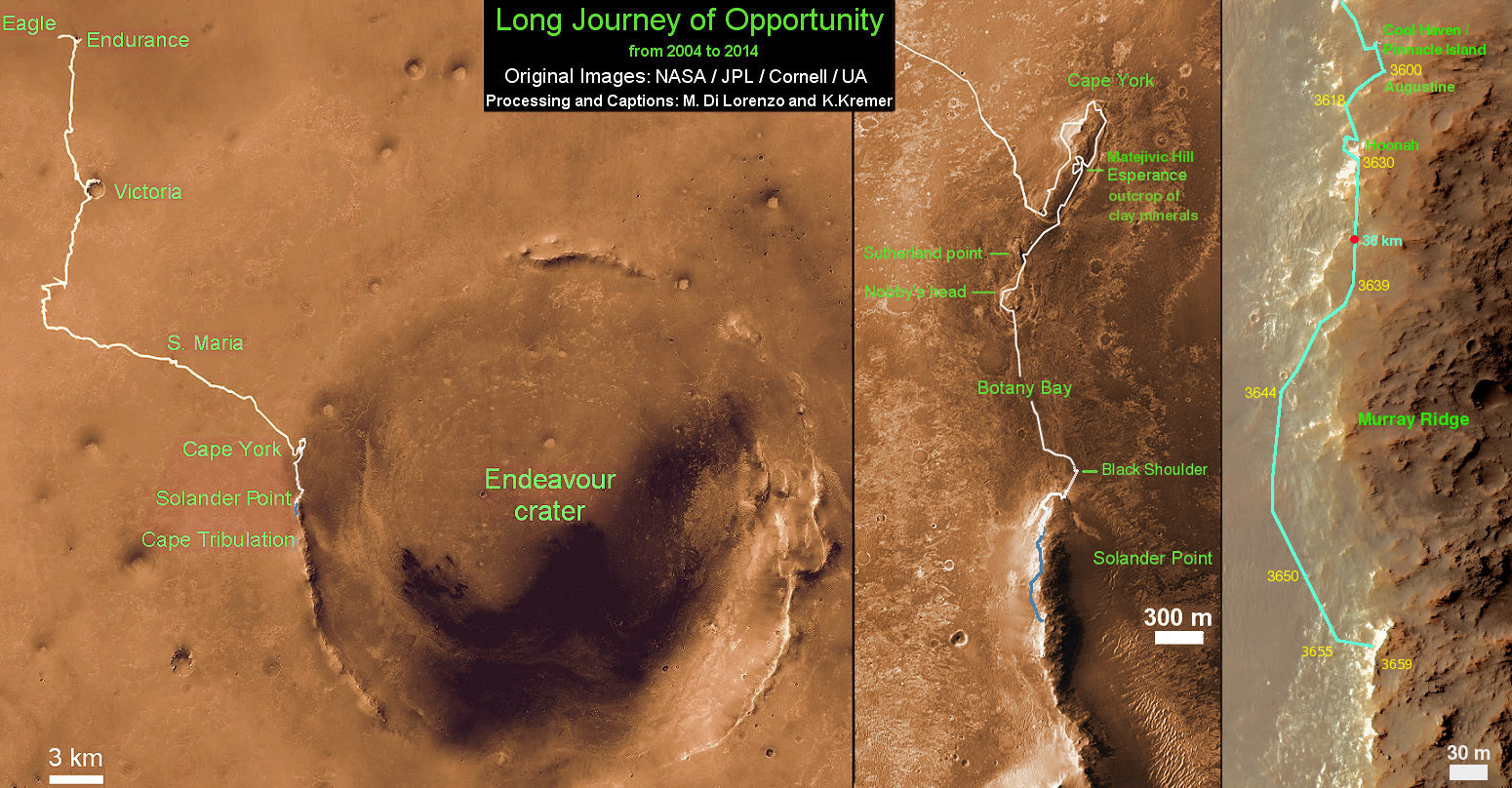
Traverse Map for NASA’s Opportunity rover from 2004 to 2014 – A Decade on Mars
This map shows the entire path the rover has driven during a decade on Mars and over 3660 Sols, or Martian days, since landing inside Eagle Crater on Jan 24, 2004 to current location along Murray Ridge south of Solander Point summit at the western rim of Endeavour Crater and heading to clay minerals at Cape Tribulation. Opportunity discovered clay minerals at Esperance – indicative of a habitable zone. Credit: NASA/JPL/Cornell/ASU/Marco Di Lorenzo/Ken Kremer
Composite photo mosaic shows deployment of NASA Curiosity rovers robotic arm and two holes after drilling into ‘Windjana’ sandstone rock on May 5, 2014, Sol 621, at Mount Remarkable as missions third drill target for sample analysis by rover’s chemistry labs. The navcam raw images were stitched together from several Martian days up to Sol 621, May 5, 2014 and colorized. Credit: NASA/JPL-Caltech/Ken Kremer - kenkremer.com/Marco Di Lorenzo
Composite photo mosaic shows deployment of NASA Curiosity rovers robotic arm and two holes after drilling into ‘Windjana’ sandstone rock on May 5, 2014, Sol 621, at Mount Remarkable as missions third drill target for sample analysis by rover’s chemistry labs. The navcam raw images were stitched together from several Martian days up to Sol 621, May 5, 2014 and colorized. Credit: NASA/JPL-Caltech/Ken Kremer – kenkremer.com/Marco Di Lorenzo
See additional Curiosity mosaics below-See our APOD featured on May 7, 2014[/caption]
After a rather satisfying test bore into a sandstone slab at “Kimberley” just last week, NASA’s rover Curiosity decided to go all the way for a deep drill excursion into the Red Planet rock target called “Windjana” and successfully collected powdery samples from the interior on Monday evening, May 5, Sol 621, that the rover will soon consume inside her belly for high tech compositional analysis with her state-of-the-art science instruments.
NASA reported the great news today, Tuesday, May 6, soon after receiving confirmation of the successful acquisition effort by the hammering drill, located at the terminus of the 1 ton robots 7-foot-long (2 meter) arm.
At long last its “Drill, Baby, Drill” time on Mars.
The “Kimberley Waypoint” drill campaign into “Windjana” at the Mount Remarkable butte thus marks only the third Martian rock bored for sampling analysis by the SUV sized rover. This also counts as a new type of Mars rock – identified as sandstone, compared to the pair of mudstone rocks bored into last year.
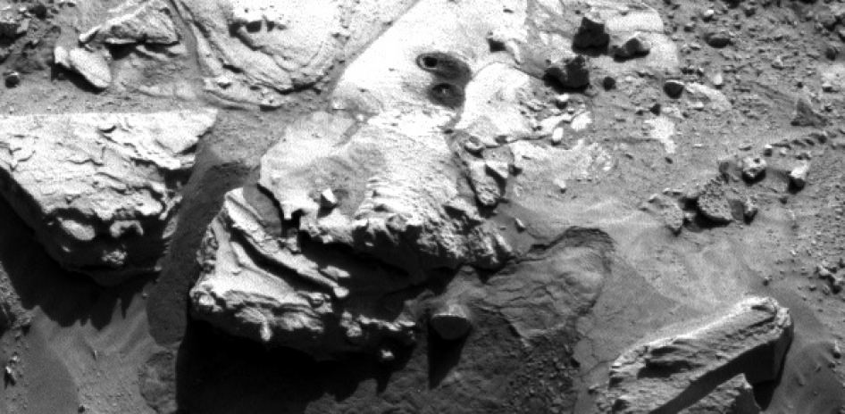
This May 5, 2014, image (Sol 621) from the Navigation Camera on NASA’s Curiosity Mars rover shows two holes at top center drilled into a sandstone target called “Windjana.” The farther hole was created by the rover’s drill while it collected rock-powder sample material from the interior of the rock that will be fed to the rovers chemistry labs for analysis. Credit: NASA/JPL-Caltech
The fresh hole in “Windjana” created on Monday night was clearly visible in images received this afternoon and showed it was 0.63 inch (1.6 centimeters) in diameter and about 2.6 inches (6.5 centimeters) deep.
The operation went exactly as planned and left behind a residual pile of drill tailings much darker in color compared to the ubiquitous red color seen covering most of Mars surface.
The new full-depth hole is very close in proximity to the shallower “Mini-drill” test hole operation carried out on April 29 at Windjama to determine if this site met the science requirements for sampling analysis and delivery to the two onboard, miniaturized chemistry labs – SAM and CheMin.
“Windjana” is named after a gorge in Western Australia.
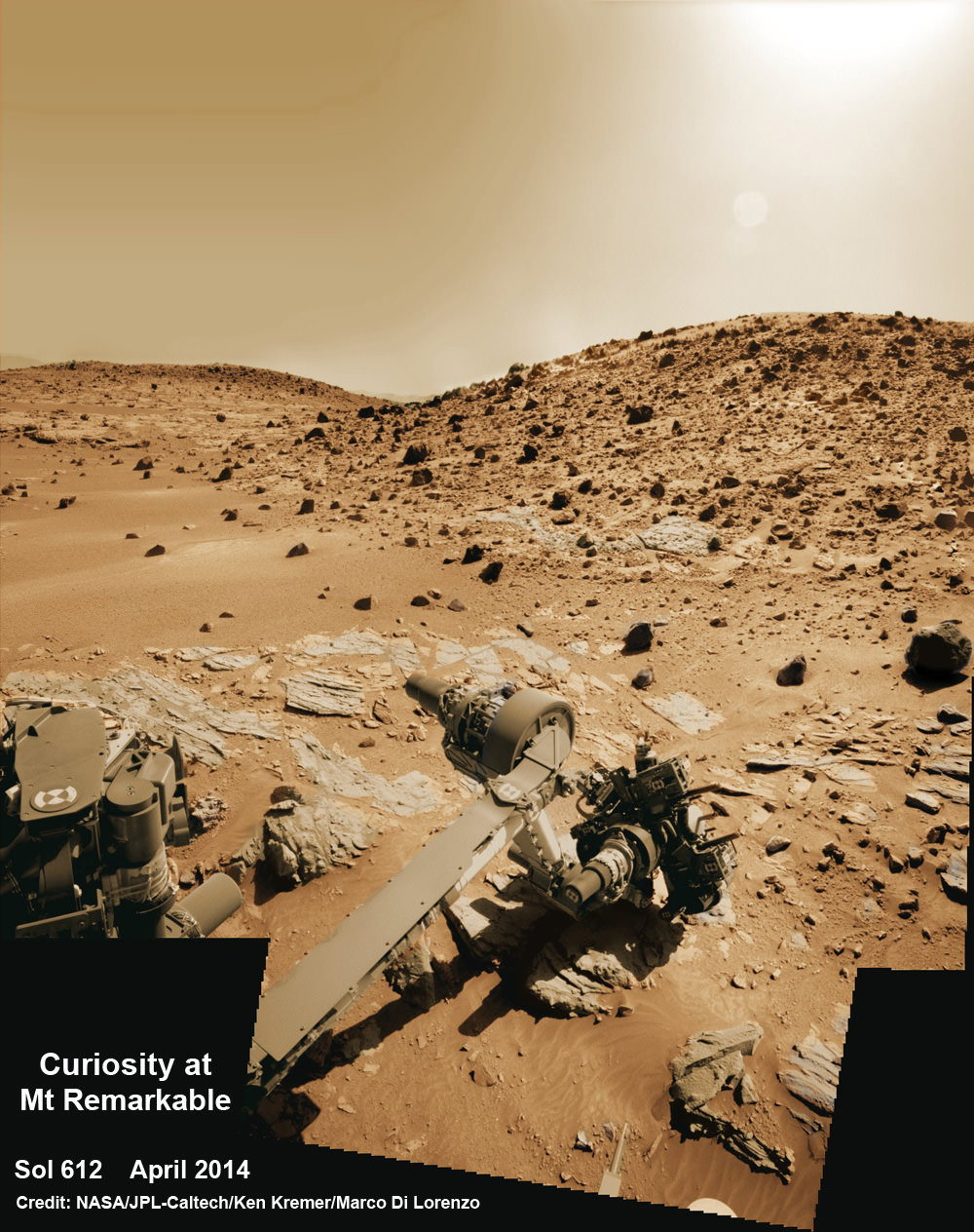
Curiosity’s Panoramic view of Mount Remarkable at ‘The Kimberley Waypoint’ where rover will conduct 3rd drilling campaign inside Gale Crater on Mars. The navcam raw images were taken on Sol 603, April 17, 2014, stitched and colorized. Credit: NASA/JPL-Caltech/Ken Kremer – kenkremer.com/Marco Di Lorenzo
Featured on APOD – Astronomy Picture of the Day on May 7, 2014
“The drill tailings from this rock are darker-toned and less red than we saw at the two previous drill sites,” said Jim Bell of Arizona State University, Tempe, deputy principal investigator for Curiosity’s Mast Camera (Mastcam).
“This suggests that the detailed chemical and mineral analysis that will be coming from Curiosity’s other instruments could reveal different materials than we’ve seen before. We can’t wait to find out!”
In coming days, the sample will be pulverized and sieved prior to delivery to the Chemistry and Mineralogy instrument (CheMin) and the Sample Analysis at Mars instrument (SAM) for chemical and compositional analysis.
Windjana is an outcrop of sandstone located at the base of a Martian butte named Mount Remarkable at “The “Kimberley Waypoint” – a science stopping point reached by the rover in early April 2014 halfway along its epic trek to towering Mount Sharp, the primary destination of the mission.
See herein our illustrative photo mosaics of the Kimberly Waypoint region assembled by the image processing team of Marco Di Lorenzo and Ken Kremer.
Multisol composite photo mosaic shows deployment of Curiosity’s rovers robotic arm and APXS X-ray spectrometer onto the ‘Winjana’ rock target at Mount Remarkable for evaluation as missions third drill target inside Gale Crater on Mars. The colorized navcam raw images were stitched together from several Martian days up to Sol 612, April 26, 2014. Credit: NASA/JPL-Caltech/Ken Kremer – kenkremer.com/Marco Di Lorenzo
The first two drill campaigns conducted during 2013 at ‘John Klein’ and ‘Cumberland’ inside Yellowknife Bay were on mudstone rock outcrops.
The science team chose Windjana for drilling “to analyze the cementing material that holds together sand-size grains in this sandstone,” says NASA.
“The Kimberley Waypoint was selected because it has interesting, complex stratigraphy,” Curiosity Principal Investigator John Grotzinger, of the California Institute of Technology, Pasadena, told me.
Curiosity snaps selfie at Kimberley waypoint with towering Mount Sharp backdrop on April 27, 2014 (Sol 613). Inset shows MAHLI camera image of rovers mini-drill test operation on April 29, 2014 (Sol 615) into “Windjana” rock target at Mount Remarkable butte. MAHLI color photo mosaic assembled from raw images snapped on Sol 613, April 27, 2014. Credit: NASA/JPL/MSSS/Marco Di Lorenzo/Ken Kremer – kenkremer.com
Curiosity departed the ancient lakebed at the Yellowknife Bay region in July 2013 where she discovered a habitable zone with the key chemical elements and a chemical energy source that could have supported microbial life billions of years ago – and thereby accomplished the primary goal of the mission.
Windjama is about 2.5 miles (4 kilometers) southwest of Yellowknife Bay.
Curiosity still has about another 4 kilometers to go to reach the base of Mount Sharp sometime later this year.
Martian landscape with rows of curved rock outcrops at ‘Kimberly’ in the foreground and spectacular Mount Sharp on the horizon. NASA’s Curiosity Mars rover pulled into Kimberly waypoint dominated by layered rock outcrops as likely drilling site. This colorized navcam camera photomosaic was assembled from imagery taken on Sol 576 (Mar. 20, 2014). Credit: NASA/JPL-Caltech/Marco Di Lorenzo/Ken Kremer-kenkremer.com
The sedimentary foothills of Mount Sharp, which reaches 3.4 miles (5.5 km) into the Martian sky, is the 1 ton robots ultimate destination inside Gale Crater because it holds caches of water altered minerals. Such minerals could possibly indicate locations that sustained potential Martian life forms, past or present, if they ever existed.
Stay tuned here for Ken’s continuing Curiosity, Opportunity, Chang’e-3, SpaceX, Orbital Sciences, LADEE, MAVEN, MOM, Mars and more planetary and human spaceflight news.
Curiosity scans scientifically intriguing rock outcrops of gorgeous Martian terrain at ‘The Kimberley’ waypoint in search of next drilling location beside Mount Remarkable butte, at right. Mastcam color photo mosaic assembled from raw images snapped on Sol 590, April 4, 2014. Credit: NASA/JPL/MSSS/Marco Di Lorenzo/Ken Kremer – kenkremer.com
Artist's rendering of Kepler-186f (Credit: NASA Ames/SETI Institute/Caltech)
It wasn’t so long ago that we found out there is an Earth-sized planet in a habitable zone of a star. But how many others are out there, and do we know if planets like this are truly habitable?
“Looking towards the future, what we really want to do eventually is transform our knowledge from planets in the habitable zone to [characterizing] planetary environments,” said Natalie Batalha, a co-investigator on NASA’s Kepler Space Telescope, in a webcast presentation today (April 28) .
This means that astronomers will be able to, from a distance, look at “biosignatures” of life in the atmosphere. What a biosignature would be is still being characterized, but it could be something like an unusually high proportion of oxygen — as long as abiotic processes are not accounted for, of course.
Batalha identified these parameters for finding other Earths in a presentation at the “Habitable Worlds Across Time and Space” conference presented by the Space Telescope Science Institute:
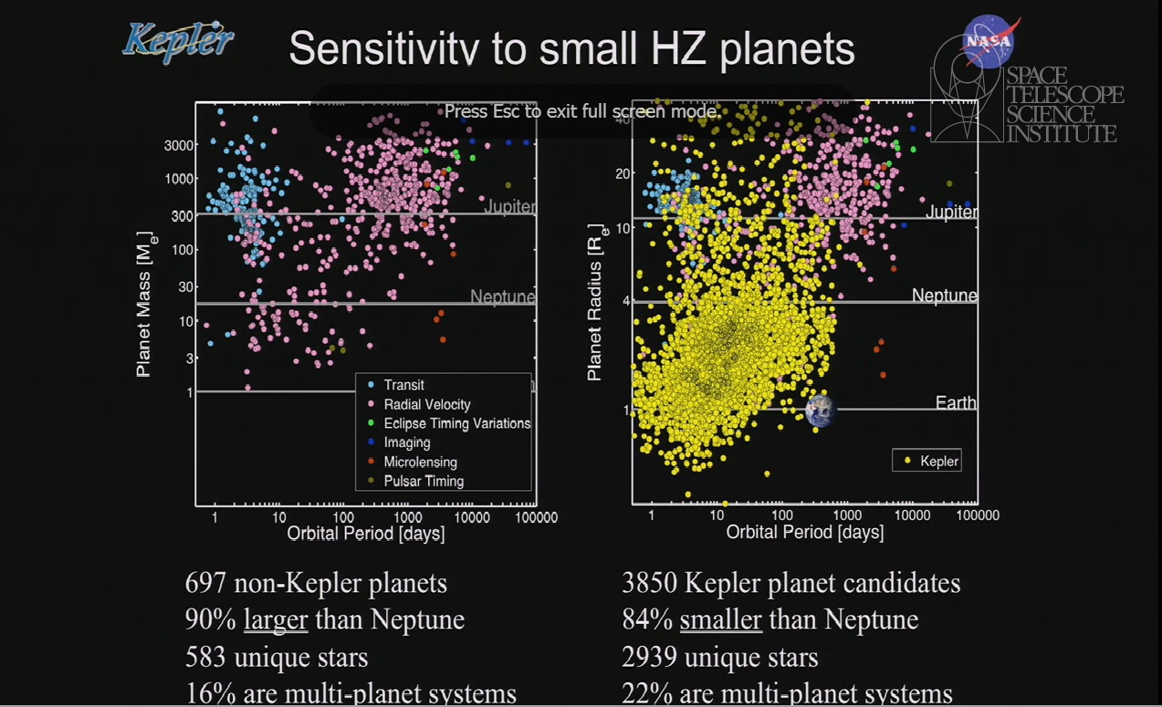
Detections of planets in the habitable zone: other telescopes (left) vs. the Kepler space telescope. Credit: Natalie Batalha / NASA (screenshot)
– The telescope must be sensitive to an Earth-sized planet in the habitable zone of a G, K or M-type star (which are stars that are like the sun);
– A uniform and reliable detection catalog with well-understood sizes, orbital periods and insolation fluxes (energy received from the sun);
– Knowledge of Kepler’s detection efficiency and the planetary catalog’s reliability;
– Well-documented and accessible data products for other community members to analyze.
What would also be helpful to planetary scientists is learning more about how a planet forms in the habitable region of its star.
Meet Kepler-22b, an exoplanet with an Earth-like radius in the habitable zone of its host star. Unfortunately its mass remains unknown. Image Credit: NASA
In a presentation at the same conference, the University of Toronto’s Diana Valencia (an astrophysicist) pointed out there is no single predictor for how large a planet will get. It depends on how close a planetesimal disc is to its star, the rate of accretion in the area and dust opacity, among other factors.
She also gave a brief overview of processes that demonstrate how hard it is to predict habitability. Earth had at least two atmospheres in its past, presentation slides said, with the first atmosphere lost and the second built from volcanism and impacts. Valencia also pointed to complexities involving the Earth’s mantle and plate tectonics.