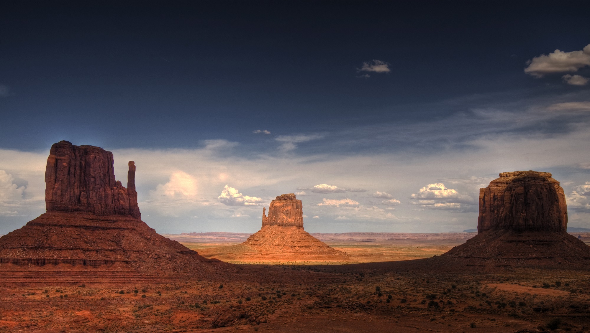
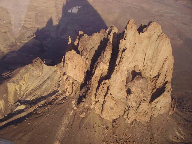
Image of the Mittens and Merrick Butte, in Monument Valley, Arizona. Credit: Wikipedia Commons/Wolfgang Staudt
During the 16h century, Spanish explorers ventured north from Mexico looking for gold and the legendary “Seven cities of Cibola”. What they found instead were some of the most amazing natural formations in the world, which are today known as “buttes”. To the local Hopi, Navajo, and other indigenous nations, these features – which resemble tall, isolated plateaus – have been regarded as sacred sites since time immemorial.
By the beginning of the 19th century, the term “butte” entered common parlance and quickly became adopted by the geological community. And while their existence was something of a mystery for thousands of years, spawning mythological connections and folk tales, improvements in the fields of Earth sciences and geology have led scientists to understand what these features are and how they are formed.
Definition:
By definition, a Butte is a conspicuous isolated hill with steep, often vertical sides and a small, relatively flat top. The word “butte” comes from a French word meaning “small hill”. They are not to be confused with Mesas or Plateaus, which are typically differentiated based on the fact that their top surfaces are larger than their vertical faces, while a butte is taller than it is wide. However, definitions of the surface areas of mesas and buttes vary.
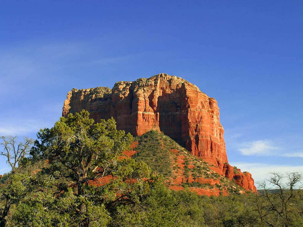
The Courthouse Butte, located near the town of Sedona, Arizona. Credit: Wikipedia Commons
One source states that a mesa has a surface area of less than 10 square kilometers, while a butte has a surface area less than 1,000 square meters. Another source states that the surface area of a mesa is larger than 2.59 square kilometers. However, all sides are in agreement that is the difference between their vertical and horizontal measurements that are key.
Formation:
Both buttes and mesas are formed by the same geological process, which involves the physical weathering of rock formations. Essentially, this involves the surface material of a hill or mountain (the cap rock) resists wind and water erosion, but the underlying materials do not. Over time, the underlying material is stripping away, leaving an isolated, standing feature with a flat top.
The top layer of a butte is a hardened layer of rock that is resistant to erosion. This top layer, called the cap rock, is usually composed of sedimentary rock, but sometimes is the remains of cooled and hardened lava that had spread out across the landscape in repeated flows from fissures or cracks in the ground.
Beneath this flat, protective cap of rock, horizontal layers of softer sedimentary rock are found. To varying degrees, these layers are not as resistant to wind and water erosion. As a result, when the softer rock is stripped away, a standing, isolated rock is left behind. Typically, buttes are found in arid and semiarid regions.
Merrick’s Butte, in Monument Valley, Utah. Credit: Wikipedia Commons/Ernst Brötz
Because water evaporates quickly in these normally dry environments, plants and other ground cover are scarce. Left exposed to the action of running water, the bare sides of the softer rock layers of buttes are eroded away over time. The base of these landforms is often gently sloped, contrasting with the almost-vertical sides leading down from the top. Rock material that has been eroded from the sides is carried downward, forming this sloping base.
Notable Buttes:
Because of their isolated and imposing nature, many buttes have become geographical land markers and major tourist destinations. They also figured prominently in the spiritual beliefs and creation myths of the indigenous peoples across North America. Buttes can be found all over North America, though they are most commonly found in the arid regions of the American Southwest.
For example, there is the Courthouse Butte, a prominent feature located just north of the Village of Oak Creek, and south of the town of Sedona in Yavapai County. Then there’s the Elephant Butte, which is located in the Elephant Butte Lake State Park in Sierra Country, New Mexico,. This geographical feature is so-named because of the combination of a vertical side and a sloping side, which resemble the shape of an elephant.
Bear Butte in South Dakota also has a long history of being a geological and cultural significant feature. Long before the arrival of European settlers, Bear Butte featured prominently in the religious and mythological traditions of the Lakota, Sioux and Cheyenne nations. To the Lakota and Sioux, the feature was known as “Matho Paha” (literally, Bear Mountain), while the Cheyenne referred to it as Nahkohe-vose (“bear hill”).
Bear Butte (aka. Bear Mountain or Bear Hill),, located in South Dakota. Credit: Jerrye & Roy Klotz, MD.
According to Cheyenne mythology, it was here that Ma’heo’o (God, or the Great Spirit) imparted the knowledge from which the Cheyenne base their religion, political, social and economic customs to the prophet Sweet Medicine. Today, the location remains a sacred site for many indigenous peoples, who make pilgrimages to leave prayer cloths and tobacco bundles tied to branches taken from the trees that surround the butte.
To the north, buttes can be found in the Canadian provinces of Saskatchewan, Alberta and British Columbia, in regions that are arid and semi-arid. For example, there is the Pilot Butte, which is located in southern Saskatchewan, near the town of the same name. This feature’s name is derived from the fact that the flat-topped butte served as a lookout for hunting buffalo and as a landmark for planes approaching the provincial capitol of Regina.
And there’s Lone Butte, a prehistoric basalt feature located in the southern Cariboo Plateau in central British Columbia. A part of the geological formation known as the Chilcotin Group, this feature was formed roughly six million years ago as a result of the extensive volcanic activity in the region.
Buttes on Other Planets:
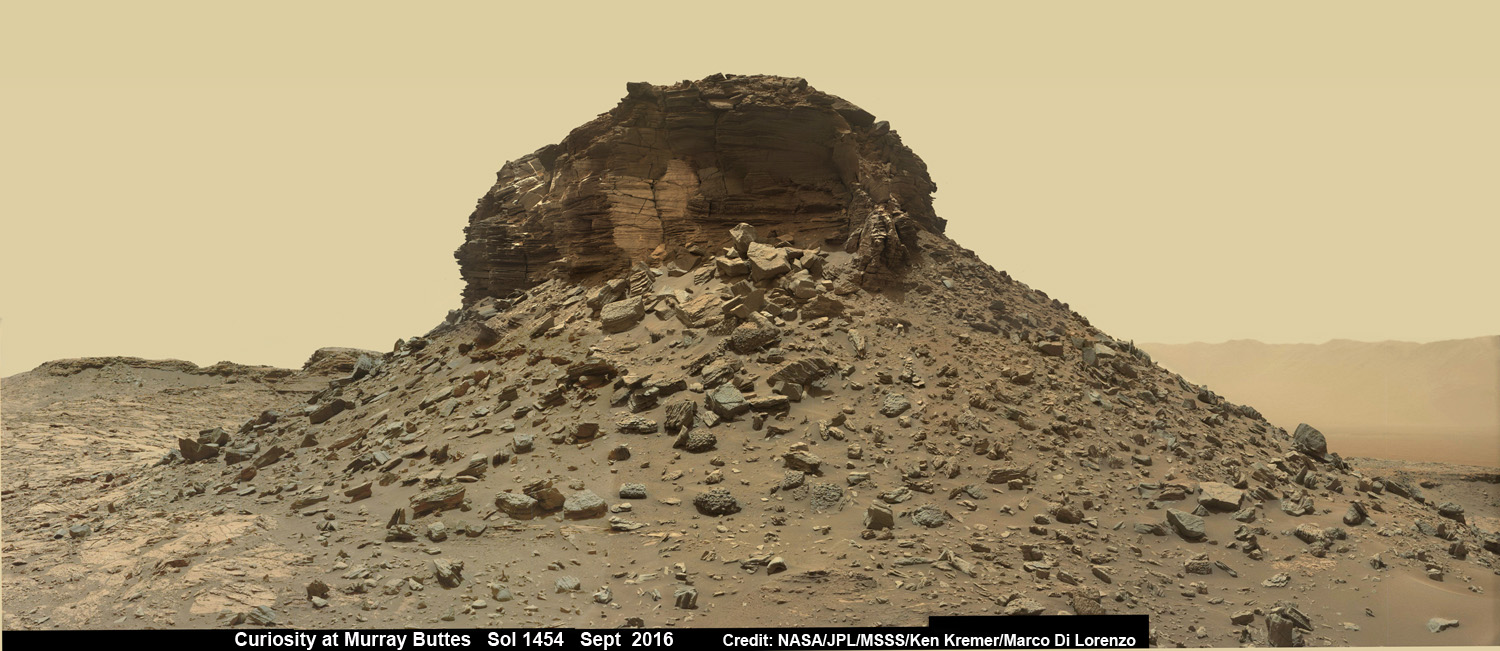
Buttes have also been spotted on other planets in the Solar System, where they are also linked to geological activity and erosion. For example, NASA’s Curiosity rover mission has taken extensive images of the area currently known as the “Murray Buttes” region on Mars, which is located in the lower region of Mount Sharp (in the Gale Crater). In addition, Curiosity has taken drill samples from the surface rock in the region.
Wide-angle mosaic of a butte with sandstone layers showing cross-bedding, in the Murray Buttes region on lower Mount Sharp. Credit: NASA/JPL/MSSS/Ken Kremer/Marco Di Lorenzo
At one time, this crater was believed to be a standing body of water, which was largely responsible for the creation of these features. As Ashwin Vasavada, the Curiosity Project Scientist of NASA’s Jet Propulsion Laboratory, described the area as being “reminiscent of parts of the American southwest because of its butte and mesa landscape. In both areas, thick layers of sediment were deposited by wind and water, eventually resulting in a “layer cake” of bedrock that then began to erode away as conditions changed. In both places, more resistant sandstone layers cap the mesas and buttes because they protect the more easily eroded, fine-grained rock underneath. ”
Buttes have also been photographed by the Mars Reconnaissance Orbiter’s (MRO) HiRISE instrument. These include the many buttes spotted in the Candor Chasma region – part of the Valles Marineris canyon system – back in 2007. The Viking 1 orbiter also noted the presence of many buttes in the Cydonia region during its flyby in 1976 – the occasion when it took pictures of the “Face of Mars” (later revealed to be a mesa).
Much like polygonal ridges that have been observed in the Medusae Fossae region and other locations across Mars (and Earth), these features are believed to be the remains of volcanic rock that remained in place after the surrounding rock was stripped away by erosion.
Ongoing studies into the various forces that shape our planet has allowed us to understand just how dynamic and changing it is. In addition, developments in space exploration and the planetary sciences have helped us to realize that Earth has a lot in common with other planets in our Solar System.
Volcanoes are an impressive force of nature. Physically, they dominate the landscape, and have an active role in shaping our planet’s geography. When they are actively erupting, they are an extremely dangerous and destructive force. But when they are passive, the soil they enrich can become very fertile, leading to settlements and cities being built nearby.
Such is the nature of volcanoes, and is the reason why we distinguish between those that are “active” and those that are “dormant”. But what exactly is the differences between the two, and how do geologists tell? This is actually a complicated question, because there’s no way to know for sure if a volcano is all done erupting, or if it’s going to become active again.
Put simply, the most popular way for classifying volcanoes comes down to the frequency of their eruption. Those that erupt regularly are called active, while those that have erupted in historical times but are now quiet are called dormant (or inactive). But in the end, knowing the difference all comes down to timing!
Sarychev volcano, (located in Russia’s Kuril Islands, northeast of Japan) in an early stage of eruption on June 12, 2009. Credit: NASA
Active Volcano:
Currently, there is no consensus among volcanologists about what constitutes “active”. Volcanoes – like all geological features – can have very long lifespans, varying between months to even millions of years. In the past few thousand years, many of Earth’s volcanoes have erupted many times over, but currently show no signs of impending eruption.
As such, the term “active” can mean only active in terms of human lifespans, which are entirely different from the lifespans of volcanoes. Hence why scientists often consider a volcano to be active only if it is showing signs of unrest (i.e. unusual earthquake activity or significant new gas emissions) that mean it is about to erupt.
Aleutian island #volcano letting off a little steam after the new year on Jan 2, 2016. #YearInSpace. Credit: NASA/Scott Kelly/@StationCDRKelly
By this definition, those volcanoes that have erupted in the course of human history (which includes more than 500 volcanoes) are defined as active. However, this too is problematic, since this varies from region to region – with some areas cataloging volcanoes for thousands of years, while others only have records for the past few centuries.
As such, an “active volcano” can be best described as one that’s currently in a state of regular eruptions. Maybe it’s going off right now, or had an event in the last few decades, or geologists expect it to erupt again very soon. In short, if its spewing fire or likely to again in the near future, then it’s active!
Dormant Volcano:
Meanwhile, a dormant volcano is used to refer to those that are capable of erupting, and will probably erupt again in the future, but hasn’t had an eruption for a very long time. Here too, definitions become complicated since it is difficult to distinguish between a volcano that is simply not active at present, and one that will remain inactive.
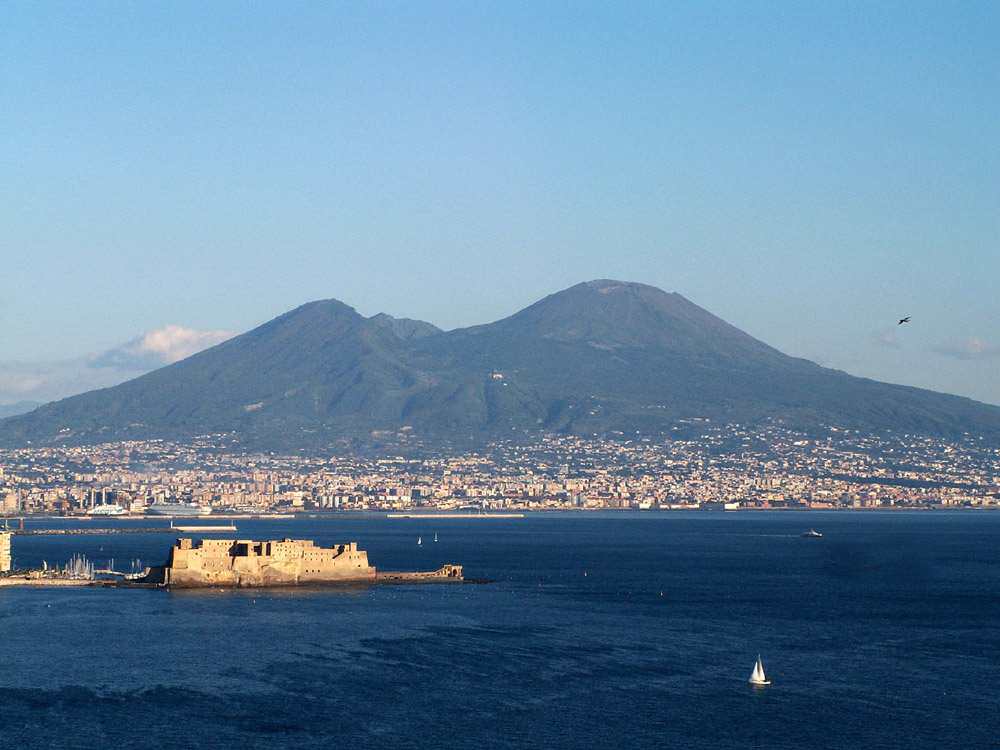
Volcanoes are often considered to be extinct if there are no written records of its activity. Nevertheless, volcanoes may remain dormant for a long period of time. For instance, the volcanoes of Yellowstone, Toba, and Vesuvius were all thought to be extinct before their historic and devastating eruptions.
The area around Mount Vesuvius, which erupted in 79 CE, is now densely populated. Credit: Wikipedia Commons/Jeffmatt
The same is true of the Fourpeaked Mountain eruption in Alaska in 2006. Prior to this, the volcano was thought to be extinct since it had not erupted for over 10,000 years. Compare that to Mount Grímsvötn in south-east Iceland, which erupted three times in the past 12 years (in 2011, 2008 and 2004, respectively).
And so a dormant volcano is actually part of the active volcano classification, it’s just that it’s not currently erupting.
Extinct Volcano:
Geologists also employ the category of extinct volcano to refer to volcanoes that have become cut off from their magma supply. There are many examples of extinct volcanoes around the world, many of which are found in the Hawaiian-Emperor Seamount Chain in the Pacific Ocean, or stand individually in some areas.
For example, the Shiprock volcano, which stands in Navajo Nation territory in New Mexico, is an example of a solitary extinct volcano. Edinburgh Castle, located just outside the capitol of Edinburgh, Scotland, is famously located atop an extinct volcano.
Aerial photograph of the Shiprock extinct volcano. Credit: Wikipedia Commons
But of course, determining if a volcano is truly extinct is often difficult, since some volcanoes can have eruptive lifespans that measure into the millions of years. As such, some volcanologists refer to extinct volcanoes as inactive, and some volcanoes once thought to be extinct are now referred to as dormant.
In short, knowing if a volcano is active, dormant, or extinct is complicated and all comes down to timing. And when it comes to geological features, timing is quite difficult for us mere mortals. Individuals and generations have limited life spans, nations rise and fall, and even entire civilization sometimes bite the dust.
But volcanic formations? They can endure for millions of years! Knowing if there still life in them requires hard work, good record-keeping, and (above all) immense patience.
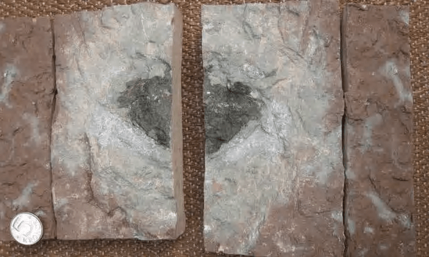
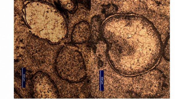
Osterplana 65, the meteorite at the heart of a mystery. This meteorite is different than the thousands of other meteorites in collections around the world. Image: Birger Schmitz
470 million years ago, somewhere in our Solar System, there was an enormous collision between two asteroids. We know this because of the rain of meteorites that struck Earth at that time. But inside that rain of meteorites, which were all of the same type, there is a mystery: an oddball, different from the rest. And that oddball could tell us something about how rocks from space can change ecosystems, and allow species to thrive.
This oddball meteorite has a name: Osterplana 65. It’s a fossilized meteorite, and it was found in a limestone quarry in Sweden. Osterplana 65 fell to Earth some 470 mya, during the Ordovician period, and sank to the bottom of the ocean. There, it became sequestered in a bed of limestone, itself created by the sea-life of the time.
The Ordovician period is marked by a couple thing: a flourishing of life similar to the Cambrian period that preceded it, and a shower of meteors called the Ordovician meteor event. There is ample evidence of the Ordovician meteor event in the form of meteorites, and they all conform to similar chemistry and structure. So it’s long been understood that they all came from the same parent body.
The collision that caused this rain of meteorites had to have two components, two parent bodies, and Osterplana 65 is evidence that one of these parent bodies was different. In fact, Ost 65 represents a so far unknown type of meteorite.
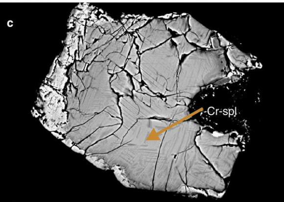
The faint grey lines in this electron image of Ost 65 are called “shock deformation lamellae” and they are evidence that Ost 65 was the result of a collision. Image: B. Schmidt
The study that reported this finding was published in Nature on June 14 2016. As the text of the study says, “Although single random meteorites are possible, one has to consider that Öst 65 represents on the order of one per cent of the meteorites that have been found on the mid-Ordovician sea floor. “It goes on to say, “…Öst 65 may represent one of the dominant types of meteorites arriving on Earth 470 Myr ago.”
The discovery of a type of meteorite falling on Earth 470 mya, and no longer falling in our times, is important for a couple reasons. The asteroid that produced it is probably no longer around, and there is no other source for meteorites like Ost 65 today.
The fossil record of a type of meteorite no longer in existence may help us unravel the story of our Solar System. The asteroid belt itself is an ongoing evolution of collision and destruction. It seems reasonable that some types of asteroids that were present in the earlier Solar System are no longer present, and Ost 65 provides evidence that that is true, in at least one case.
Ost 65 shows us that the diversity in the population of meteorites was greater in the past than it is today. And Ost 65 only takes us back 470 mya. Was the population even more diverse even longer ago?
The Earth is largely a conglomeration of space rocks, and we know that there are no remnants of these Earthly building blocks in our collections of meteorites today. What Ost 65 helps prove is that the nature of space rock has changed over time, and the types of rock that came together to form Earth are no longer present in space.
Ost 65 was found in amongst about 100 other meteorites, which were all of the same type. It was found in the garbage dump part of the quarry. It’s presence is a blemish on the floor tiles that are cut at the quarry. Study co-author Birgen Schmitz told the BBC in an interview that “It used to be that they threw away the floor tiles that had ugly black dots in them. The very first fossil meteorite we found was in one of their dumps.”
According to Schmitz, he and his colleagues have asked the quarry to keep an eye out for these types of defects in rocks, in case more of them are fossilized meteorites.
Finding more fossilized meteorites could help answer another question that goes along with the discovery of Ost 65. Did the types and amounts of space rock falling to Earth at different times help shape the evolution of life on Earth? If Ost 65 was a dominant type of meteorite falling to Earth 470 mya, what effect did it have? There appear to be a confounding number of variables that have to be aligned in order for life to appear and flourish. A shower of minerals from space at the right time could very well be one of them.
Whether that question ever gets answered is anybody’s guess at this point. But Ost 65 does tell us one thing for certain. As the text of the study says, “Apparently there is potential to reconstruct important aspects of solar-system history by looking down in Earth’s sediments, in addition to looking up at the skies.”
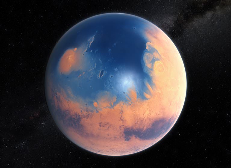
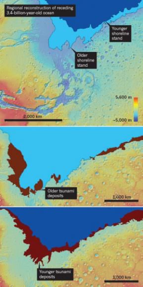
An artist's impression of the ancient Martian ocean. When two meteors slammed into Mars 3.4 billion years ago, they triggered massive, 400 ft. tsunamis that reshaped the coastline. Image: ESO/M. Kornmesser, via N. Risinger
About 3.4 billion years ago, (according to a new study) when the Late Heavy Bombardment had ended, and the first cells resembling prokaryotes were appearing on Earth, two enormous meteoroids slammed into the ancient, frigid ocean on Mars. These impacts generated massive 400 ft. high tsunamis that reshaped the shoreline of the Martian ocean, leaving behind fields of sediments and boulders.
It was long thought that ancient Mars had oceans. Sedimentary deposits discovered in the Martian north by radar in 2012 helped make the case for Martian oceans. 3.4 billion years ago, this ocean covered most of the Northern Martian lowlands. It’s thought that the ocean itself was fed by catastrophic flooding, perhaps fuelled by geothermal activity on Mars at the time.
These catastrophic tsunamis would have dwarfed most Earthly disasters. Waves 120 meters high would have swamped landmarks like the Statue of Liberty (93 m. high), and caused enormous destruction along the Martian coastline. If the research behind this new study stands up to scrutiny, then it will help prove the existence of the ancient Martian ocean.
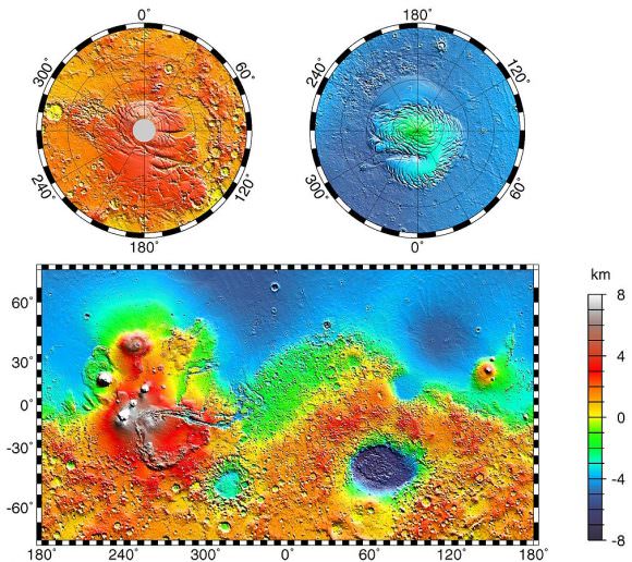
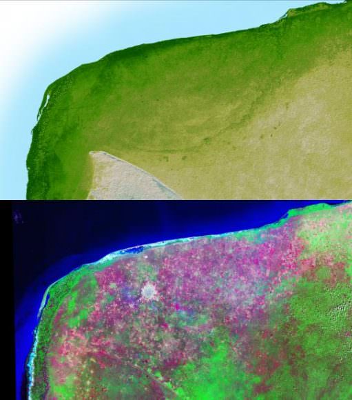
The blue area in the above image is thought to be the location of a primordial ocean Mars. Image: NASA/JPL-Caltech/GSFC – Public Domain
The Martian surface shows the remains of an ancient ocean. In some areas, radar data shows a layer of water-borne sediment on top of a layer of volcanic rock. There’s also evidence of a shoreline, described by some scientists as being like a bathtub ring. The problems is, the shoreline can’t be seen everywhere it should be.
The tsunami hypothesis helps explain this missing shoreline.
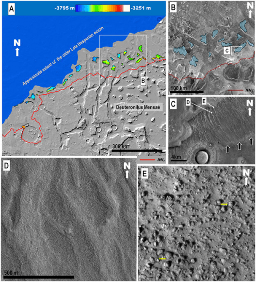
According to the new study, led by Alexis Rodriguez, a Mars researcher at the Planetary Science Institute in Tucson Arizona, the tsunamis would have wiped away portions of the coastline, and left behind fields of sediment and boulders, and large backwash channels cut into the Martian surface.
The study is focussed on a specific region on Mars where a highland feature called Arabia Terra abuts the Chryse Planitia lowlands. This area was part of the shoreline of the Martian ocean. In that area, the team behind the study identified two separate geological formations that they say were created by two separate tsunami events.
The top image shows the shoreline of the ancient Martian shoreline at two separate times. The bottom images show debris left behind by the two tsunamis. Image: Alexis Rodriguez.
The first formation, and older of the two, looks every bit like a disturbed shoreline. An enormous wave washed over the beach, and in its wake deposited boulders over 10 meters across. Then, as the water drained back down into the ocean, it cut large backwash channels through its debris and boulder field.
A sequence of zoomed in images of the Martian surface in the study. (A) shows distances and elevations of backwash channels. (B) shows some of the channel-scoured, north-sloping highland mesas in blue. (C) shows the channelled surface, and (D) shows them in closer detail. Finally, (E) is zoomed in to show boulders as much as 10 m. in diameter. (Yellow bars are 10m.) Image: A,B:MOLA Science Team, MSS, JPL, NASA. C,D,E: NASA/JPL/University of Arizona
Then, some time passed. Millions of years, probably, until the second meteor hit, triggering another enormous tsunami. But this one behaved a little differently.
Conditions on Mars had changed by then, with temperatures dropping, and glaciers marching across the landscape, gouging out deep valleys on the surface of Mars. When the second tsunami hit the shore, its effect was different.
This time, the tsunami was more like an icy slurry, according to the team. Because of the cold temperatures, the icy water froze in place in some areas, before it could wash back into the ocean. The result? Deposits of frozen debris formed in dense lobes on the surface.
This long lobe of dark material on the surface of Mars was left behind when a tsunami of icy flush washed over the Martian coastline, freezing in place before it could wash back into the sea. Image: Alexis Rodriquez
But according to Rodriguez, this is just a snapshot of a process that likely occurred multiple times in the history of Mars. Successive meteors could have caused successive mega-tsunamis that would have repeatedly wiped away evidence of a shoreline. This could have happened as often as every 3 million years.
This study isn’t the knockout blow that proves the existence of a Martian ocean in ancient times. But it is certainly intriguing, and is a reasonable hypothesis that explains missing shorelines.
Rodriguez intends to keep looking for other evidence of tsunamis on the Martian surface. If he finds more, it will help make the case for the meteor-tsunami explanation.
Rodriguez will also be visiting places on Earth that are analogues for the Martian surface of ancient times. This summer he plans on visiting high-altitude, cold, alpine lakes in Tibet, where he hopes to learn something about the processes and geological formations involved.
Even better would be a mission to Mars, to sample the area where the tsunamis came ashore. A group of small craters near the shore that were drenched by the tsunamis is of particular interest to Rodriguez and his team. Martian ocean water could have been trapped there for millions of years. This site could provide evidence about the briny nature of the ancient ocean on Mars, and possibly tell us something about the evolution of life there.
Few forces in nature are are impressive or frightening as a volcanic eruption. In an instant, from within the rumbling depths of the Earth, hot lava, steam, and even chunks of hot rock are spewed into the air, covering vast distances with fire and ash. And thanks to the efforts of geologists and Earth scientists over the course of many centuries, we have to come to understand a great deal about them.
However, when it comes to the nomenclature of volcanoes, a point of confusion often arises. Again and again, one of the most common questions about volcanoes is, what is the difference between lava and magma? They are both molten rock, and are both associated with volcanism. So why the separate names? As it turns out, it all comes down to location.
Earth’s Composition:
As anyone with a basic knowledge of geology will tell you, the insides of the Earth are very hot. As a terrestrial planet, its interior is differentiated between a molten, metal core, and a mantle and crust composed primarily of silicate rock. Life as we know it, consisting of all vegetation and land animals, live on the cool crust, whereas sea life inhabits the oceans that cover a large extent of this same crust.
The Earth’s layers, showing the Inner and Outer Core, the Mantle, and Crust. Credit: discovermagazine.com
However, the deeper one goes into the planet, both pressures and temperatures increase considerably. All told, Earth’s mantle extends to a depth of about 2,890 km, and is composed of silicate rocks that are rich in iron and magnesium relative to the overlying crust. Although solid, the high temperatures within the mantle cause pockets of molten rock to form.
This silicate material is less dense than the surrounding rock, and is therefore sufficiently ductile that it can flow on very long timescales. Over time, it will also reach the surface as geological forces push it upwards. This happens as a result of tectonic activity.
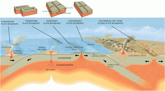
Basically, the cool, rigid crust is broken into pieces called tectonic plates. These plates are rigid segments that move in relation to one another at one of three types of plate boundaries. These are known as convergent boundaries, at which two plates come together; divergent boundaries, at which two plates are pulled apart; and transform boundaries, in which two plates slide past one another laterally.
Interactions between these plates are what is what is volcanic activity (best exemplified by the “Pacific Ring of Fire“) as well as mountain-building. As the tectonic plates migrate across the planet, the ocean floor is subducted – the leading edge of one plate pushing under another. At the same time, mantle material will push up at divergent boundaries, forcing molten rock to the surface.
The Earth’s Tectonic Plates. Credit: msnucleus.org
Magma:
As already noted, both lava and magma are what results from rock superheated to the point where it becomes viscous and molten. But again, the location is the key. When this molten rock is still located within the Earth, it is known as magma. The name is derived from Greek, which translate to “thick unguent” (a word used to describe a viscous substance used for ointments or lubrication).
It is composed of molten or semi-molten rock, volatiles, solids (and sometimes crystals) that are found beneath the surface of the Earth. This vicious rock usually collects in a magma chamber beneath a volcano, or solidify underground to form an intrusion. Where it forms beneath a volcano, it can then be injected into cracks in rocks or issue out of volcanoes in eruptions. The temperature of magma ranges between 600 °C and 1600 °C.
Magma is also known to exist on other terrestrial planets in the Solar System (i.e. Mercury, Venus and Mars) as well as certain moons (Earth’s Moon and Jupiter’s moon Io). In addition to stable lava tubes being observed on Mercury, the Moon and Mars, powerful volcanoes have been observed on Io that are capable of sending lava jets 500 km (300 miles) into space.
Igneous rock (aka. “fire rock”) is formed from cooled and solidified lava. Credit: geologyclass.org
Lava:
When magma reaches the surface and erupts from a volcano, it officially becomes lava. There are actually different kinds of lava depending on its thickness or viscosity. Whereas the thinnest lava can flow downhill for many kilometers (thus creating a gentle slope), thicker lavas will pile up around a volcanic vent and hardly flow at all. The thickest lava doesn’t even flow, and just plugs up the throat of a volcano, which in some cases cause violent explosions.
The term lava is usually used instead of lava flow. This describes a moving outpouring of lava, which occurs when a non-explosive effusive eruption takes place. Once a flow has stopped moving, the lava solidifies to form igneous rock. Although lava can be up to 100,000 times more viscous than water, lava can flow over great distances before cooling and solidifying.
The word “lava” comes from Italian, and is probably derived from the Latin word labes which means “a fall” or “slide”. The first use in connection with a volcanic event was apparently in a short written account by Franscesco Serao, who observed the eruption of Mount Vesuvius between May 14th and June 4th, 1737. Serao described “a flow of fiery lava” as an analogy to the flow of water and mud down the flanks of the volcano following heavy rain.
Such is the difference between magma and lava. It seems that in geology, as in real estate, its all about location!
This is an artist’s depiction of a 10-kilometer (6-mile) diameter asteroid striking the Earth. New evidence in Australia suggests an asteroid 2 to 3 times larger than this struck Earth early in its life. Credit: Don Davis/Southwest Research Institute.
New evidence found in northwestern Australia suggests that a massive asteroid, 20 to 30 kilometres in diameter, struck Earth about 3.5 billion years ago. This impact would have dwarfed anything experienced by humans, and dinosaurs, releasing as much energy as millions of nuclear weapons. Impacts this large can trigger earthquakes and tsunamis, and change the geological history of Earth.
The evidence was uncovered by Andrew Glikson and Arthur Hickman from the Australian National University. While drilling for the Geological Survey of Western Australia, the two obtained drilling cores from some of the oldest known sediments on Earth. Sandwiched between two layers of sediment were tiny glass beads called spherules, which were formed from vaporized material from the asteroid impact.
Impact spherules formed from material vaporized by an asteroid impact. Image: A. Glikson/Australian National University
The enormity of this impact cannot be overstated. “The impact would have triggered earthquakes orders of magnitude greater than terrestrial earthquakes, it would have caused huge tsunamis and would have made cliffs crumble,” said Dr. Glikson, from the ANU Planetary Institute.
This asteroid impact is the second oldest one that we know of. It is also one of the largest found yet, and at 20 to 30 kilometers in diameter, it is 2 the 3 times the size of the famous Chicxulub asteroid that struck the Yucatan in Mexico. That impact is thought to be responsible for ending the age of dinosaurs on Earth.
This image shows a very faint circular outline of the Chicxulub crater. After 65 million years, it is barely visible. All evidence of craters billions of years old would now be gone. Image: NASA/JPL
The crater itself would have been hundreds of kilometers in diameter, though all traces of it are now gone. “Exactly where this asteroid struck the earth remains a mystery,” Dr. Glikson said. “Any craters from this time on Earth’s surface have been obliterated by volcanic activity and tectonic movements.”
“Material from the impact would have spread worldwide. These spherules were found in sea floor sediments that date from 3.46 billion years ago,” said Glikson.
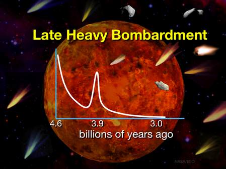
At 3.46 billion years ago, this puts this impact event close to a period of time 4.1 to 3.8 billion years ago known as the Late Heavy Bombardment. This was a period of time when a disproportionate number of asteroids struck the Earth and the Moon, and probably Mercury, Venus, and Mars, too. The Late Heavy Bombardment was probably caused by the gas giants in our Solar System. As these planets migrated, their gravity caused enormous disruption, pulling objects in the asteroid belt and the Kuiper Belt into trajectories that sent them towards the inner Solar System.
The Late Heavy Bombardment is thought to be a period of time when the Earth, and the rest of the bodies in the inner Solar System, were repeatedly struck by asteroids. Image: NASA/ESA
The surfaces of Mercury and the Moon are covered in impact craters. Samples of rock from the lunar surface, brought back to Earth by the Apollo astronauts, have been subjected to isotopic dating. Their age is constrained to a fairly narrow band of time, corresponding to the Late Heavy Bombardment. Obviously, the Earth would have been subjected to the same thing. But on geologically active Earth, most traces of impact events have been erased. It’s the sediment that hints at these events.
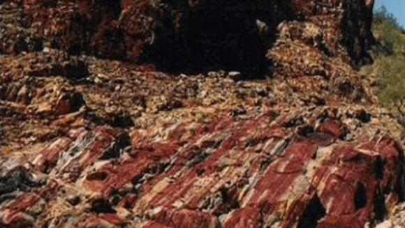
Australia is geologically ancient, and contains some of the most ancient rocks on Earth. Glikson and Hickman found the glass spherules in cores while drilling at Marble Bar in north-western Australia. Because the sediment layer containing the spherules was preserved between two volcanic layers, its age was determined with great precision.
The sediments at Marble Bar, north-western Australia, where the spherules were found. Image: A Glikson/Australian National University
For over 20 years, Dr. Glikson has been searching for evidence of asteroid impacts. When these glass beads were found in the core samples, he suspected an asteroid impact. Testing confirmed that the levels of elements such as platinum, nickel and chromium, matched those in asteroids.
This is not the first evidence of impact events that Glikson has uncovered. In 2015, Glikson discovered evidence of another massive asteroid strike in the Warburton Basin in Central Australia. At that site, buried in the crust 30 kilometers deep, in rock that is 300 to 500 million years old, Glikson found evidence of a double impact crater covering an area 400 kilometers wide.
This crater was believed to be the result of an asteroid that broke into two before slamming into Earth. “The two asteroids must each have been over 10 kilometers (6.2 miles) across — it would have been curtains for many life species on the planet at the time,” said Glikson.
“There may have been many more similar impacts, for which the evidence has not been found, said Dr. Glikson. “This is just the tip of the iceberg. We’ve only found evidence for 17 impacts older than 2.5 billion years, but there could have been hundreds.”
Finding the sites of ancient impacts is not easy. Advances in satellite imaging helped locate and pinpoint the Chicxulub crater, and others. If there have been hundreds of enormous asteroid impacts, like Dr. Glikson suggests, then they would have had an equally enormous impact on Earth’s evolution. But pinpointing these sites remains elusive.
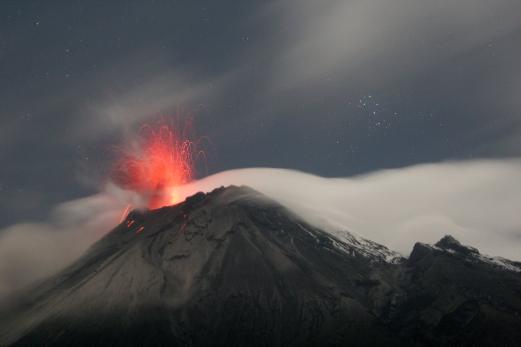
Tungurahua ("throat of fire"), an active stratovolcano in Ecuador. Credit: Patrick Taschler
Without a doubt, volcanoes are one of the most powerful forces of nature a person can bear witness to. Put simply, they are what results when a massive rupture takes place in the Earth’s crust (or any planetary-mass object), spewing hot lava, volcanic ash, and toxic fumes onto the surface and air. Originating from deep within the Earth’s crust, volcanoes leave a lasting mark on the landscape.
But what are the specific parts of a volcano? Aside from the “volcanic cone” (i.e. the cone-shaped mountain), a volcano has many different parts and layers, most of which are located within the mountainous region or deep within the Earth. As such, any true understanding of their makeup requires that we do a little digging (so to speak!)
While volcanoes come in a number of shapes and sizes, certain common elements can be discerned. The following gives you a general breakdown of a volcanoes specific parts, and what goes into making them such a titanic and awesome natural force.
Magma Chamber:
A magma chamber is a large underground pool of molten rock sitting underneath the Earth’s crust. The molten rock in such a chamber is under extreme pressure, which in time can lead to the surrounding rock fracturing, creating outlets for the magma. This, combined with the fact that the magma is less dense than the surrounding mantle, allows it to seep up to the surface through the mantle’s cracks.
Lava cooling after an eruption from Kilauea, a shield volcano near Kalapana, Hawaii Credit: kalapanaculturaltours.com
When it reaches the surface, it results in a volcanic eruption. Hence why many volcanoes are located above a magma chamber. Most known magma chambers are located close to the Earth’s surface, usually between 1 km and 10 km deep. In geological terms, this makes them part of the Earth’s crust – which ranges from 5–70 km (~3–44 miles) deep.
Lava:
Lava is the silicate rock that is hot enough to be in liquid form, and which is expelled from a volcano during an eruption. The source of the heat that melts the rock is known as geothermal energy – i.e. heat generated within the Earth that is leftover from its formation and the decay of radioactive elements. When lava first erupted from a volcanic vent (see below), it comes out with a temperature of anywhere between 700 to 1,200 °C (1,292 to 2,192 °F). As it makes contact with air and flows downhill, it eventually cools and hardens.
Main Vent:
A volcano’s main vent is the weak point in the Earth’s crust where hot magma has been able to rise from the magma chamber and reach the surface. The familiar cone-shape of many volcanoes are an indication of this, the point at which ash, rock and lava ejected during an eruption fall back to Earth around the vent to form a protrusion.
Throat:
The uppermost section of the main vent is known as the volcano’s throat. As the entrance to the volcano, it is from here that lava and volcanic ash are ejected.
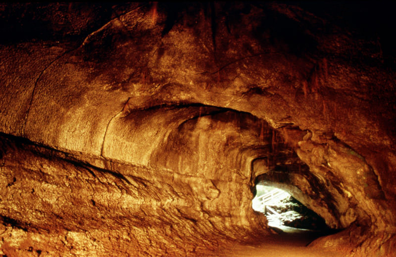
Thurston lava tube is located on Kilauea in Hawaii. Credit: P. Mouginis-Mark, LPI
Crater:
In addition to cone structures, volcanic activity can also lead to circular depressions (aka. craters) forming in the Earth. A volcanic crater is typically a basin, circular in form, which can be large in radius and sometimes great in depth. In these cases, the lava vent is located at the bottom of the crater. They are formed during certain types of climactic eruptions, where the volcano’s magma chamber empties enough for the area above it to collapse, forming what is known as a caldera.
Pyroclastic Flow:
Otherwise known as a pyroclastic density current, a pyroclastic flow refers to a fast-moving current of hot gas and rock that is moving away from a volcano. Such flows can reach speeds of up to 700 km/h (450 mph), with the gas reaching temperatures of about 1,000 °C (1,830 °F). Pyroclastic flows normally hug the ground and travel downhill from their eruption site.
Their speeds depend upon the density of the current, the volcanic output rate, and the gradient of the slope. Given their speed, temperature, and the way they flow downhill, they are one of the greatest dangers associated with volcanic eruptions and are one of the primary causes of damage to structures and the local environment around an eruption site.
Ash Cloud:
Volcanic ash consists of small pieces of pulverized rock, minerals and volcanic glass created during a volcanic eruption. These fragments are generally very small, measuring less than 2 mm (0.079 inches) in diameter. This sort of ash forms as a result of volcanic explosions, where dissolved gases in magma expand to the point where the magma shatters and is propelled into the atmosphere. The bits of magma then cool, solidifying into fragments of volcanic rock and glass.
Because of their size and the explosive force with which they are generated, volcanic ash is picked up by winds and dispersed up to several kilometers away from the eruption site. Due to this dispersal, ash an also have a damaging effect on the local environment, which includes negatively affecting human and animal health, disrupting aviation, disrupting infrastructure, and damaging agriculture and water systems. Ash is also produced when magma comes into contact with water, which causes the water to explosively evaporate into steam and for the magma to shatter.
Volcanic Bombs:
In addition to ash, volcanic eruptions have also been known to send larger projectiles flying through the air. Known as volcanic bombs, these ejecta are defined as those that measure more than 64mm (2.5 inches) in diameter, and which are formed when a volcano ejects viscous fragments of lava during an eruption. These cool before they hit the ground, are thrown many kilometers from the eruption site, and often acquire aerodynamic shapes (i.e. streamlined in form).
While the term applies to any ejecta larger than a few centimeters, volcanic bombs can sometimes be very large. There have been recorded instances where objects measuring several meters were retrieved hundreds of meters from an eruptions. Small or large, volcanic bombs are a significant volcanic hazard and can often cause serious damage and multiple fatalities, depending on where they land. Luckily, such explosions are rare.
Secondary Vent:
On large volcanoes, magma can reach the surface through several different vents. Where they reach the surface of the volcano, they form what is referred to as a secondary vent. Where they are interrupted by accumulated ash and solidified lava, they become what is known as a Dike. And where these intrude between cracks, pool and then crystallize, they form what is called a Sill.
Cross-section of a stratovolcano: 1. Magma chamber 2. Bedrock 3. Vent 4. Base 5. Sill 6. Dike 7. Layers of ash 8. Flank 9. Layers of lava 10. Throat 11. Parasitic cone 12. Lava flow 13. Vent 14. Crater 15. Ash cloud. Credit: MesserWoland
Secondary Cone:
Also known as a Parasitic Cone, secondary cones build up around secondary vents that reach the surface on larger volcanoes. As they deposit lava and ash on the exterior, they form a smaller cone, one that resembles a horn on the main cone.
Yes indeed, volcanoes are as powerful as they are dangerous. And yet, without these geological phenomena occasionally breaking through the surface and reigning down fire, smoke, and clouds of ash, the world as we know it would be a very different place. More than likely, it would be a geologically dead one, with no change or evolution in its crust. I think we can all agree that while such a world would be much safer, it would also be painfully boring!
The Earth's layers, showing the Inner and Outer Core, the Mantle, and Crust. Credit: discovermagazine.com
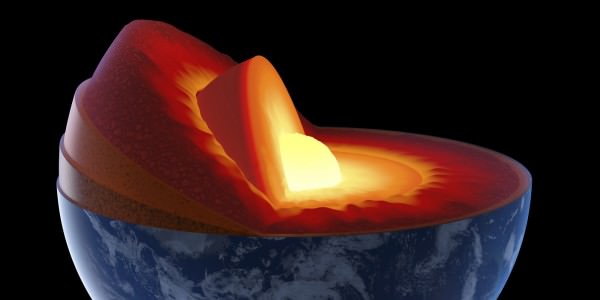
There is more to the Earth than what we can see on the surface. In fact, if you were able to hold the Earth in your hand and slice it in half, you’d see that it has multiple layers. But of course, the interior of our world continues to hold some mysteries for us. Even as we intrepidly explore other worlds and deploy satellites into orbit, the inner recesses of our planet remains off limit from us.
However, advances in seismology have allowed us to learn a great deal about the Earth and the many layers that make it up. Each layer has its own properties, composition, and characteristics that affects many of the key processes of our planet. They are, in order from the exterior to the interior – the crust, the mantle, the outer core, and the inner core. Let’s take a look at them and see what they have going on.
Modern Theory:
Like all terrestrial planets, the Earth’s interior is differentiated. This means that its internal structure consists of layers, arranged like the skin of an onion. Peel back one, and you find another, distinguished from the last by its chemical and geological properties, as well as vast differences in temperature and pressure.
Our modern, scientific understanding of the Earth’s interior structure is based on inferences made with the help of seismic monitoring. In essence, this involves measuring sound waves generated by earthquakes, and examining how passing through the different layers of the Earth causes them to slow down. The changes in seismic velocity cause refraction which is calculated (in accordance with Snell’s Law) to determine differences in density.
Model of a flat Earth, with the continents modeled in a disk-shape and Antarctica as an ice wall. Credit: Wikipedia Commons
These are used, along with measurements of the gravitational and magnetic fields of the Earth and experiments with crystalline solids that simulate pressures and temperatures in the Earth’s deep interior, to determine what Earth’s layers looks like. In addition, it is understood that the differences in temperature and pressure are due to leftover heat from the planet’s initial formation, the decay of radioactive elements, and the freezing of the inner core due to intense pressure.
History of Study:
Since ancient times, human beings have sought to understand the formation and composition of the Earth. The earliest known cases were unscientific in nature – taking the form of creation myths or religious fables involving the gods. However, between classical antiquity and the medieval period, several theories emerged about the origin of the Earth and its proper makeup.
Most of the ancient theories about Earth tended towards the “Flat-Earth” view of our planet’s physical form. This was the view in Mesopotamian culture, where the world was portrayed as a flat disk afloat in an ocean. To the Mayans, the world was flat, and at it corners, four jaguars (known as bacabs) held up the sky. The ancient Persians speculated that the Earth was a seven-layered ziggurat (or cosmic mountain), while the Chinese viewed it as a four-side cube.
By the 6th century BCE, Greek philosophers began to speculate that the Earth was in fact round, and by the 3rd century BCE, the idea of a spherical Earth began to become articulated as a scientific matter. During the same period, the development of a geological view of the Earth also began to emerge, with philosophers understanding that it consisted of minerals, metals, and that it was subject to a very slow process of change.
Illustration of Edmond Halley’s model of a Hallow Earth, one that was made up of concentric spheres. Credit: Wikipedia Commons/Rick Manning
However, it was not until the 16th and 17th centuries that a scientific understanding of planet Earth and its structure truly began to advance. In 1692, Edmond Halley (discoverer of Halley’s Comet) proposed what is now known as the “Hollow-Earth” theory. In a paper submitted to Philosophical Transactions of Royal Society of London, he put forth the idea of Earth consisting of a hollow shell about 800 km thick (~500 miles).
Between this and an inner sphere, he reasoned there was an air gap of the same distance. To avoid collision, he claimed that the inner sphere was held in place by the force of gravity. The model included two inner concentric shells around an innermost core, corresponding to the diameters of the planets Mercury, Venus, and Mars respectively.
Halley’s construct was a method of accounting for the values of the relative density of Earth and the Moon that had been given by Sir Isaac Newton, in his Philosophiæ Naturalis Principia Mathematica (1687) – which were later shown to be inaccurate. However, his work was instrumental to the development of geography and theories about the interior of the Earth during the 17th and 18th centuries.
Another important factor was the debate during the 17th and 18th centuries about the authenticity of the Bible and the Deluge myth. This propelled scientists and theologians to debate the true age of the Earth, and compelled the search for evidence that the Great Flood had in fact happened. Combined with fossil evidence, which was found within the layers of the Earth, a systematic basis for identifying and dating the Earth’s strata began to emerge.
The growing importance of mining in the 17th and 18th centuries, particularly for precious metals, led to further developments in geology and Earth sciences. Credit: minerals.usgs.gov
The development of modern mining techniques and growing attention to the importance of minerals and their natural distribution also helped to spur the development of modern geology. In 1774, German geologist Abraham Gottlob Werner published Von den äusserlichen Kennzeichen der Fossilien (On the External Characters of Minerals) which presented a detailed system for identifying specific minerals based on external characteristics.
In 1741, the National Museum of Natural History in France created the first teaching position designated specifically for geology. This was an important step in further promoting knowledge of geology as a science and in recognizing the value of widely disseminating such knowledge. And by 1751, with the publication of the Encyclopédieby Denis Diderot, the term “geology” became an accepted term.
By the 1770s, chemistry was starting to play a pivotal role in the theoretical foundation of geology, and theories began to emerge about how the Earth’s layers were formed. One popular idea had it that liquid inundation, like the Biblical Deluge, was responsible for creating all the geological strata. Those who accepted this theory became known popularly as the Diluvianists or Neptunists.
Another thesis slowly gained currency from the 1780s forward, which stated that instead of water, strata had been formed through heat (or fire). Those who followed this theory during the early 19th century referred to this view as Plutonism, which held that the Earth formed gradually through the solidification of molten masses at a slow rate. These theories together led to the conclusion that the Earth was immeasurably older than suggested by the Bible.
HMS Beagle in the Galapagos Islands, painted by John Chancellor. Credit: hmsbeagleproject.otg
In the early 19th century, the mining industry and Industrial Revolution stimulated the rapid development of the concept of the stratigraphic column – that rock formations were arranged according to their order of formation in time. Concurrently, geologists and natural scientists began to understand that the age of fossils could be determined geologically (i.e. that the deeper the layer they were found in was from the surface, the older they were).
During the imperial period of the 19th century, European scientists also had the opportunity to conduct research in distant lands. One such individual was Charles Darwin, who had been recruited by Captain FitzRoy of the HMS Beagle to study the coastal land of South America and give geological advice.
Darwin’s discovery of giant fossils during the voyage helped to establish his reputation as a geologist, and his theorizing about the causes of their extinction led to his theory of evolution by natural selection, published in On the Origin of Species in 1859.
During the 19th century, the governments of several countries including Canada, Australia, Great Britain and the United States began funding geological surveys that would produce geological maps of vast areas of the countries. Thought largely motivated by territorial ambitions and resource exploitation, they did benefit the study of geology.
The Earth’s Tectonic Plates. Credit: msnucleus.org
By this time, the scientific consensus established the age of the Earth in terms of millions of years, and the increase in funding and the development of improved methods and technology helped geology to move farther away from dogmatic notions of the Earth’s age and structure.
By the early 20th century, the development of radiometric dating (which is used to determine the age of minerals and rocks), provided the necessary the data to begin getting a sense of the Earth’s true age. By the turn of the century, geologists now believed the Earth to be 2 billion years old, which opened doors for theories of continental movement during this vast amount of time.
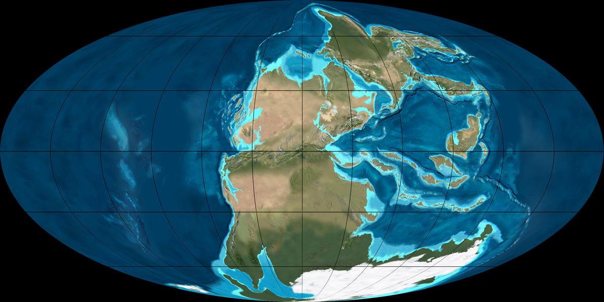
In 1912, Alfred Wegener proposed the theory of Continental Drift, which suggested that the continents were joined together at a certain time in the past and formed a single landmass known as Pangaea. In accordance with this theory, the shapes of continents and matching coastline geology between some continents indicated they were once attached together.
The super-continent Pangea during the Permian period (300 – 250 million years ago). Credit: NAU Geology/Ron Blakey
Research into the ocean floor also led directly to the theory of Plate Tectonics, which provided the mechanism for Continental Drift. Geophysical evidence suggested lateral motion of continents and that oceanic crust is younger than continental crust. This geophysical evidence also spurred the hypothesis of paleomagnetism, the record of the orientation of the Earth’s magnetic field recorded in magnetic minerals.
Then there was the development of seismology, the study of earthquakes and the propagation of elastic waves through the Earth or through other planet-like bodies, in the early 20th century. By measuring the time of travel of refracted and reflected seismic waves, scientists were able to gradually infer how the Earth was layered and what lay deeper at its core.
For example, in 1910, Harry Fielding Ried put forward the “elastic rebound theory”, based on his studies of the 1906 San Fransisco earthquake. This theory, which stated that earthquakes occur when accumulated energy is released along a fault line, was the first scientific explanation for why earthquakes happen, and remains the foundation for modern tectonic studies.
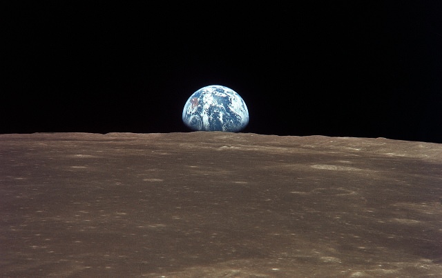
Earth viewed from the Moon by the Apollo 11 spacecraft. Credit: NASA
Then in 1926, English scientist Harold Jeffreys claimed that below the crust, the core of the Earth is liquid, based on his study of earthquake waves. And then in 1937, Danish seismologist Inge Lehmann went a step further and determined that within the earth’s liquid outer core, there is a solid inner core.
By the latter half of the 20th century, scientists developed a comprehensive theory of the Earth’s structure and dynamics had formed. As the century played out, perspectives shifted to a more integrative approach, where geology and Earth sciences began to include the study of the Earth’s internal structure, atmosphere, biosphere and hydrosphere into one.
This was assisted by the development of space flight, which allowed for Earth’s atmosphere to be studied in detail, as well as photographs taken of Earth from space. In 1972, the Landsat Program, a series of satellite missions jointly managed by NASA and the U.S. Geological Survey, began supplying satellite images that provided geologically detailed maps, and have been used to predict natural disasters and plate shifts.
Earth’s Layers:
The Earth can be divided into one of two ways – mechanically or chemically. Mechanically – or rheologically, meaning the study of liquid states – it can be divided into the lithosphere, asthenosphere, mesospheric mantle, outer core, and the inner core. But chemically, which is the more popular of the two, it can be divided into the crust, the mantle (which can be subdivided into the upper and lower mantle), and the core – which can also be subdivided into the outer core, and inner core.
The inner core is solid, the outer core is liquid, and the mantle is solid/plastic. This is due to the relative melting points of the different layers (nickel–iron core, silicate crust and mantle) and the increase in temperature and pressure as depth increases. At the surface, the nickel-iron alloys and silicates are cool enough to be solid. In the upper mantle, the silicates are generally solid but localized regions of melt exist, leading to limited viscosity.
In contrast, the lower mantle is under tremendous pressure and therefore has a lower viscosity than the upper mantle. The metallic nickel–iron outer core is liquid because of the high temperature. However, the intense pressure, which increases towards the inner core, dramatically changes the melting point of the nickel–iron, making it solid.
The differentiation between these layers is due to processes that took place during the early stages of Earth’s formation (ca. 4.5 billion years ago). At this time, melting would have caused denser substances to sink toward the center while less-dense materials would have migrated to the crust. The core is thus believed to largely be composed of iron, along with nickel and some lighter elements, whereas less dense elements migrated to the surface along with silicate rock.
Earth’s Crust:
The crust is the outermost layer of the planet, the cooled and hardened part of the Earth that ranges in depth from approximately 5-70 km (~3-44 miles). This layer makes up only 1% of the entire volume of the Earth, though it makes up the entire surface (the continents and the ocean floor).
The Earth’s layers (strata) shown to scale. Credit: pubs.usgs.gov
The thinner parts are the oceanic crust, which underlies the ocean basins at a depth of 5-10 km (~3-6 miles), while the thicker crust is the continental crust. Whereas the oceanic crust is composed of dense material such as iron magnesium silicate igneous rocks (like basalt), the continental crust is less dense and composed of sodium potassium aluminum silicate rocks, like granite.
The uppermost section of the mantle (see below), together with the crust, constitutes the lithosphere – an irregular layer with a maximum thickness of perhaps 200 km (120 mi). Many rocks now making up Earth’s crust formed less than 100 million (1×10⁸) years ago. However, the oldest known mineral grains are 4.4 billion (4.4×10⁹) years old, indicating that Earth has had a solid crust for at least that long.
Upper Mantle:
The mantle, which makes up about 84% of Earth’s volume, is predominantly solid, but behaves as a very viscous fluid in geological time. The upper mantle, which starts at the “Mohorovicic Discontinuity” (aka. the “Moho” – the base of the crust) extends from a depth of 7 to 35 km (4.3 to 21.7 mi) downwards to a depth of 410 km (250 mi). The uppermost mantle and the overlying crust form the lithosphere, which is relatively rigid at the top but becomes noticeably more plastic beneath.
Compared to other strata, much is known about the upper mantle, thanks to seismic studies and direct investigations using mineralogical and geological surveys. Movement in the mantle (i.e. convection) is expressed at the surface through the motions of tectonic plates. Driven by heat from deeper in the interior, this process is responsible for Continental Drift, earthquakes, the formation of mountain chains, and a number of other geological processes.
Computer simulation of the Earth’s field in a period of normal polarity between reversals. Credit: science.nasa.govThe mantle is also chemically distinct from the crust, in addition to being different in terms of rock types and seismic characteristics. This is due in large part to the fact that the crust is made up of solidified products derived from the mantle, where the mantle material is partially melted and viscous. This causes incompatible elements to separate from the mantle, with less dense material floating upward and solidifying at the surface.
The crystallized melt products near the surface, upon which we live, are typically known to have a lower magnesium to iron ratio and a higher proportion of silicon and aluminum. These changes in mineralogy may influence mantle convection, as they result in density changes and as they may absorb or release latent heat as well.
In the upper mantle, temperatures range between 500 to 900 °C (932 to 1,652 °F). Between the upper and lower mantle, there is also what is known as the transition zone, which ranges in depth from 410-660 km (250-410 miles).
Lower Mantle:
The lower mantle lies between 660-2,891 km (410-1,796 miles) in depth. Temperatures in this region of the planet can reach over 4,000 °C (7,230 °F) at the boundary with the core, vastly exceeding the melting points of mantle rocks. However, due to the enormous pressure exerted on the mantle, viscosity and melting are very limited compared to the upper mantle. Very little is known about the lower mantle apart from that it appears to be relatively seismically homogeneous.
The internal structure of Earth. Credit: Wikipedia Commons/Kelvinsong
Outer Core:
The outer core, which has been confirmed to be liquid (based on seismic investigations), is 2300 km thick, extending to a radius of ~3,400 km. In this region, the density is estimated to be much higher than the mantle or crust, ranging between 9,900 and 12,200 kg/m3. The outer core is believed to be composed of 80% iron, along with nickel and some other lighter elements.
Denser elements, like lead and uranium, are either too rare to be significant or tend to bind to lighter elements and thus remain in the crust. The outer core is not under enough pressure to be solid, so it is liquid even though it has a composition similar to that of the inner core. The temperature of the outer core ranges from 4,300 K (4,030 °C; 7,280 °F) in the outer regions to 6,000 K (5,730 °C; 10,340 °F) closest to the inner core.
Because of its high temperature, the outer core exists in a low viscosity fluid-state that undergoes turbulent convection and rotates faster than the rest of the planet. This causes eddy currents to form in the fluid core, which in turn creates a dynamo effect that is believed to influence Earth’s magnetic field. The average magnetic field strength in Earth’s outer core is estimated to be 25 Gauss (2.5 mT), which is 50 times the strength of the magnetic field measured on Earth’s surface.
Inner Core:
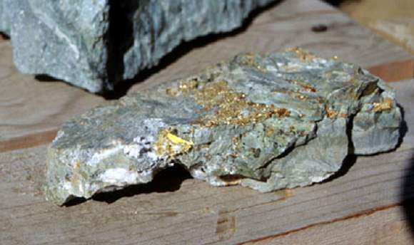
Like the outer core, the inner core is composed primarily of iron and nickel and has a radius of ~1,220 km. Density in the core ranges between 12,600-13,000 kg/m³, which suggests that there must also be a great deal of heavy elements there as well – such as gold, platinum, palladium, silver and tungsten.
Artist’s illustration of Earth’s core, inner core, and inner-inner core. Credit: Huff Post Science
The temperature of the inner core is estimated to be about 5,700 K (~5,400 °C; 9,800 °F). The only reason why iron and other heavy metals can be solid at such high temperatures is because their melting temperatures dramatically increase at the pressures present there, which ranges from about 330 to 360 gigapascals.
Because the inner core is not rigidly connected to the Earth’s solid mantle, the possibility that it rotates slightly faster or slower than the rest of Earth has long been considered. By observing changes in seismic waves as they passed through the core over the course of many decades, scientists estimate that the inner core rotates at a rate of one degree faster than the surface. More recent geophysical estimates place the rate of rotation between 0.3 to 0.5 degrees per year relative to the surface.
Recent discoveries also suggest that the solid inner core itself is composed of layers, separated by a transition zone about 250 to 400 km thick. This new view of the inner core, which contains an inner-inner core, posits that the innermost layer of the core measures 1,180 km (733 miles) in diameter, making it less than half the size of the inner core. It has been further speculated that while the core is composed of iron, it may be in a different crystalline structure that the rest of the inner core.
What’s more, recent studies have led geologists to conjecture that the dynamics of deep interior is driving the Earth’s inner core to expand at the rate of about 1 millimeter a year. This occurs mostly because the inner core cannot dissolve the same amount of light elements as the outer core.
The freezing of liquid iron into crystalline form at the inner core boundary produces residual liquid that contains more light elements than the overlying liquid. This in turn is believed to cause the liquid elements to become buoyant, helping to drive convection in the outer core. This growth is therefore likely to play an important role in the generation of Earth’s magnetic field by dynamo action in the liquid outer core. It also means that the Earth’s inner core, and the processes that drive it, are far more complex than previously thought!
Yes indeed, the Earth is a strange and mysteries place, titanic in scale as well as the amount of heat and energy that went into making it many billions of years ago. And like all bodies in our universe, the Earth is not a finished product, but a dynamic entity that is subject to constant change. And what we know about our world is still subject to theory and guesswork, given that we can’t examine its interior up close.
As the Earth’s tectonic plates continue to drift and collide, its interior continues to undergo convection, and its core continues to grow, who knows what it will look like eons from now? After all, the Earth was here long before we were, and will likely continue to be long after we are gone.
Sarychev volcano, (located in Russia's Kuril Islands, northeast of Japan) in an early stage of eruption on June 12, 2009. Credit: NASA
What if someone were to tell you that there’s a region in the world where roughly 90% of the world’s earthquakes occur. What if they were to tell you that this region is also home to over 75% of the world’s active and dormant volcanoes, and all but 3 of the world’s 25 largest eruptions in the last 11,700 years took place here.
Chances are, you’d think twice about buying real-estate there. But strangely enough, hundreds of millions of people live in this area, and some of the most densely-packed cities in the world have been built atop its shaky faults. We are talking about the Pacific Ring of Fire, a geologically and volcanically active region that stretches from one side of the Pacific to the other.
Definition:
Also known as the circum-Pacific belt, the “Ring of Fire” is a 40,000 km (25,000 mile) horseshoe-shaped basin that is associated with a nearly continuous series of oceanic trenches, volcanic arcs, and volcanic belts and/or plate movements. This ring accounts for 452 volcanoes (active and dormant), stretching from the southern tip of South America, up along the coast of North America, across the Bering Strait, down through Japan, and into New Zealand – with several active and dormant volcanoes in Antarctica closing the ring.
Tectonic Activity:
The Ring of Fire is the direct result of plate tectonics and the movement and collisions of lithospheric plates. These plates, which constitute the outer layer of the planet, are constantly in motion atop the mantle. Sometimes they collide, pull apart, or slide alongside each other; resulting in convergent boundaries, divergent boundaries, and transform boundaries.
The Pacific Ring of Fire, a string of volcanic regions extending from the South Pacific to South America. Credit: Public Domain
In the case of the former, subduction zones are often the result, where the heavier plate slips under the lighter plate – forming a deep trench. This subduction changes the dense mantle into buoyant magma, which rises through the crust to the Earth’s surface. Over millions of years, this rising magma creates a series of active volcanoes known as a volcanic arc.
These ocean trenches and volcanic arcs run parallel to one another. For instance, the Aleutian Islands in the U.S. state of Alaska run parallel to the Aleutian Trench. Both geographic features continue to form as the Pacific Plate subducts beneath the North American Plate. Meanwhile, the Andes Mountains of South America run parallel to the Peru-Chile Trench, created as the Nazca Plate subducts beneath the South American Plate.
In the case of divergent boundaries, these are formed when tectonic plates pull apart, forming rift valleys on the seafloor. When this happens, magma wells up in the rift as the old crust pulls itself in opposite directions, where it is cooled by seawater to form new crust. This upward movement and eventual cooling of this magma has created high ridges on the ocean floor over millions of years.
The East Pacific Rise is a site of major seafloor spreading in the Ring of Fire, located on the divergent boundary of the Pacific Plate and the Cocos Plate (west of Central America), the Nazca Plate (west of South America), and the Antarctic Plate. The largest known group of volcanoes on Earth is found underwater along the portion of the East Pacific Rise between the coasts of northern Chile and southern Peru.
The different type of tectonic plate boundaries. Credit: oceanexplorer.noaa.gov
A transform boundary is formed when tectonic plates slide horizontally and parts get stuck at points of contact. Stress builds in these areas as the rest of the plates continue to move, which causes the rock to break or slip, suddenly lurching the plates forward and causing earthquakes. These areas of breakage or slippage are called faults, and the majority of Earth’s faults can be found along transform boundaries in the Ring of Fire.
The San Andreas Fault, stretching along the central west coast of North America, is one of the most active faults on the Ring of Fire. It lies on the transform boundary between the North American Plate, which is moving south, and the Pacific Plate, which is moving north. Measuring about 1,287 kilometers (800 miles) long and 16 kilometers (10 miles) deep, the fault cuts through the western part of the U.S. state of California.
Plate Boundaries:
The eastern section of the Ring of Fire is the result of the Nazca Plate and the Cocos Plate being subducted beneath the westward moving South American Plate. Meanwhile, the Cocos Plate is being subducted beneath the Caribbean Plate, in Central America. A portion of the Pacific Plate along with the small Juan de Fuca Plate are being subducted beneath the North American Plate.
Along the northern portion, the northwestward-moving Pacific plate is being subducted beneath the Aleutian Islands arc. Farther west, the Pacific plate is being subducted along the Kamchatka Peninsula arcs on south past Japan.
The Earth’s Tectonic Plates. Credit: msnucleus.org
The southern portion is more complex, with a number of smaller tectonic plates in collision with the Pacific plate from the Mariana Islands, the Philippines, Bougainville, Tonga, and New Zealand. This portion excludes Australia, since it lies in the center of its tectonic plate.
Indonesia lies between the Ring of Fire along the northeastern islands adjacent to and including New Guinea and the Alpide belt along the south and west from Sumatra, Java, Bali, Flores, and Timor. The famous and very active San Andreas Fault zone of California is a transform fault which offsets a portion of the East Pacific Rise under southwestern United States and Mexico.
Volcanic Activity:
Most of the active volcanoes on The Ring of Fire are found on its western edge, from the Kamchatka Peninsula in Russia, through the islands of Japan and Southeast Asia, to New Zealand. Mount Ruapehu in New Zealand is one of the more active volcanoes in the Ring of Fire, with yearly minor eruptions, and major eruptions occurring about every 50 years.
Krakatau, perhaps better known as Krakatoa, is an island volcano in Indonesia. Krakatoa erupts less often than Mount Ruapehu, but much more spectacularly. Beneath Krakatoa, the denser Australian Plate is being subducted beneath the Eurasian Plate. An infamous eruption in 1883 destroyed the entire island, sending volcanic gas, volcanic ash, and rocks as high as 80 kilometers (50 miles) in the air. A new island volcano, Anak Krakatau, has been forming with minor eruptions ever since.
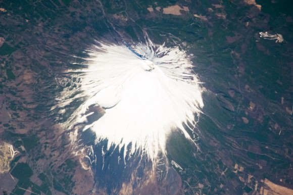
Mount Fuji, Japan, as seen from the ISS. Credit: NASA
Mount Fuji, Japan’s tallest and most famous mountain, is an active volcano in the Ring of Fire. Mount Fuji last erupted in 1707, but recent earthquake activity in eastern Japan may have put the volcano in a “critical state.” Mount Fuji sits at a “triple junction,” where three tectonic plates (the Amur Plate, Okhotsk Plate, and Philippine Plate) interact.
The Ring of Fire’s eastern half also has a number of active volcanic areas, including the Aleutian Islands, the Cascade Mountains in the western U.S., the Trans-Mexican Volcanic Belt, and the Andes Mountains. Mount St. Helens, in the U.S. state of Washington, is an active volcano in the Cascade Mountains.
Below Mount St. Helens, both the Juan de Fuca and Pacific plates are being subducted beneath the North American Plate. Its historic 1980 eruption lasted 9 hours and covered 11 U.S. states with tons of volcanic ash. The eruption caused the deaths of 57 people, over a billion dollars in property damage, and reduced hundreds of square miles to wasteland.
Popocatépetl is one of the most active and dangerous volcanoes in the Ring of Fire, with 15 recorded eruptions since 1519. The volcano lies on the Trans-Mexican Volcanic Belt, which is the result of the small Cocos Plate subducting beneath the North American Plate. Located close to the urban areas of Mexico City and Puebla, Popocatépetl poses a risk to the more than 20 million people that live close enough to be threatened by a destructive eruption.
Map of the Earth showing the relation between fault lines (blue) and zones of volcanic activity (red). Credit: zmescience.com
Earthquakes:
Scientists have known for some time that the majority of the seismic activity occurs along plate boundaries. Hence why roughly 90% of the world’s earthquakes – which is estimated to be around 500,000 a year, one-fifth of which are detectable – occur around the Pacific Rim, where multiple plate boundaries exist.
As a result, earthquakes are a regular occurrence in places like Japan, Indonesia and New Zealand in Asia and the South Pacific; Alaska, British Columbia, California and Mexico in North America; and El Salvador, Guatemala, Peru and Chile in Central and South America. Where fault lines run beneath the ocean, larger earthquakes in these regions also trigger tsunamis.
The most well-known tsumanis to take place in the Ring of Fire include the 2004 Indian Ocean earthquake and tsunami. This was the most devastating tsunami of its kind in modern times, killing around 230,000 people and laying waste to communities throughout Indonesia, Thailand, and Southern Asia.
In 2010, an earthquake triggered a tsunami which caused 4334 confirmed deaths and devastating several coastal towns in south-central Chile, including the port at Talcahuano. The earthquake also generated a blackout that affected 93 percent of the Chilean population.
In 2011, an earthquake off the Pacific coast of Tohoku led to a tsunami that struck Japan and led to 5,891 deaths, 6,152 injuries, and 2,584 people to be declared missing across twenty prefectures. The tsunami also caused meltdowns at three reactors in the Fukushima Daiichi Nuclear Power Plant complex.
The Ring of Fire is a crucial region for many reasons. It serves as one of the main boundary regions for the tectonic plates of over half of the globe. It also affects the lives of millions if not billions of people who live in these regions. For many of the people who live in the Pacific Ring of Fire, the reality of a volcanic eruption or earthquake is commonplace and a challenge they have come to deal with over time.
At the same time, the volcanic activity has also provided many valuable resources, such as rich farmland and the possibility of tapping geothermal activity for heating and electricity. As always, nature gives with one hand and takes with the other!
If you have enjoyed this article there are several others on Universe Today that you will find interesting. Here is one called 10 Interesting Facts About Volcanoes. There is also a great article about plate tectonics.
You can also find some good resources online. There is a companion site for the PBS program Savage Earth that talks about the Ring of Fire. You can also check out the USGS site to see a detailed map of the Pacific Ring of Fire and more detailed information about plate tectonics.
You can also listen to Astronomy Cast. Episode 141 talks about volcanoes.


![Computer simulation of the Earth's field in a period of normal polarity between reversals.[1] The lines represent magnetic field lines, blue when the field points towards the center and yellow when away. The rotation axis of the Earth is centered and vertical. The dense clusters of lines are within the Earth's core](https://www.universetoday.com/wp-content/uploads/2010/03/Geodynamo_Between_Reversals-e1449100829326.gif)