Impactors strike during the reign of the dinosaurs (image credit: MasPix/devianart)
There are bad days, and then there are really bad days. 65 million years ago, life on Earth – especially if you were a dinosaur – experienced the worst possible bad day, as a giant meteor came crashing down to the surface of our planet, unleashing an inferno followed by decades of nuclear winter. And the worst part? It didn’t have to be so bad.
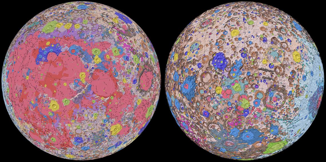
A geological map of the Moon showing different formations and mineral deposits. Credit: NASA/GSFC/USGS
The prospect of mining asteroids and the Moon is on a lot of peoples’ minds lately. Maybe it’s all the growth that’s happened in the commercial aerospace industry in the past few decades. Or perhaps it’s because of Trump’s recent executive order to allow for asteroid and lunar mining. Either way, there is no shortage of entrepreneurs and futurists who can’t wait to start prospecting and harvest the natural bounty of space!
Coincidentally enough, future lunar miners now have a complete map of the lunar surface, which was created by the US Geological Society’s (USGS) Astrogeology Science Center, in collaboration with NASA and the Lunar Planetary Institute (LPI). This map shows the distribution and classification of the mineral deposits on the Moon’s surface, effectively letting us know what its familiar patchwork of light and dark patches the really are.
Artist's depiction of a waterworld. A new study suggests that Earth is in a minority when it comes to planets, and that most habitable planets may be greater than 90% ocean. Credit: David A. Aguilar (CfA)
Evidence from an ancient section of the Earth’s crust suggest that Earth was once a water-world, some three billion years ago. If true, it’ll mean scientists need to reconsider some thinking around exoplanets and habitability. They’ll also need to reconsider their understanding of how life began on our planet.
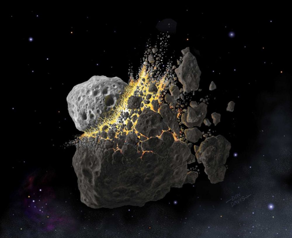
An artist's illustration of the Ordovician Meteor Event. Image Credit: DON DAVIS, SOUTHWEST RESEARCH INSTITUTE
About 466 million years ago, there was an asteroid collision in the asteroid belt between Mars and Jupiter. The collision caused the breakup of a major asteroid, creating a shower of dust throughout the inner Solar System. That event is called the Ordovician Meteor Event, and its dust caused an ice age here on Earth.
That ice age contributed to an enormous boost in biodiversity on ancient Earth.
It is believed that 4.4 billion years ago, a celestial body (Theia) slammed into Earth and produced the Moon. Image Credit: NASA/JPL-Caltech
The most comprehensive and widely-held theory of how the Moon formed is called the ‘giant impact hypothesis.’ That hypothesis shows that about 150 million years after the Solar System formed, a roughly Mars-sized planet named Theia collided with Earth. Though the timeline is hotly-debated in the scientific community, we know that this collision melted Theia and some of Earth, and that molten rock orbited around Earth until it coalesced into the Moon.
But now a new study, though not contradicting the giant impact hypothesis, is suggesting a different timeline, and an older Moon.
People always want to know how old everything is. And more specifically, they want to know how we know how old everything is. Well, here at Astronomy Cast, it’s our job to tell you now only what we know, but how we know what we know. And today we’ll begin a series on how we know how old everything is.
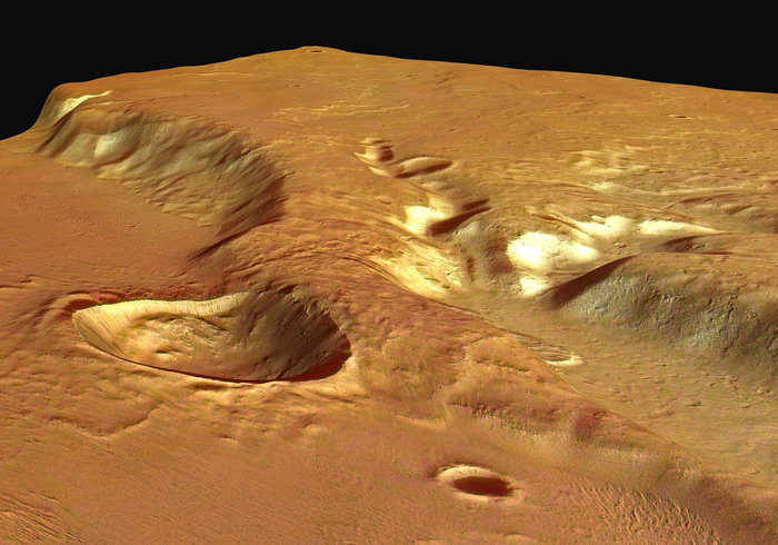
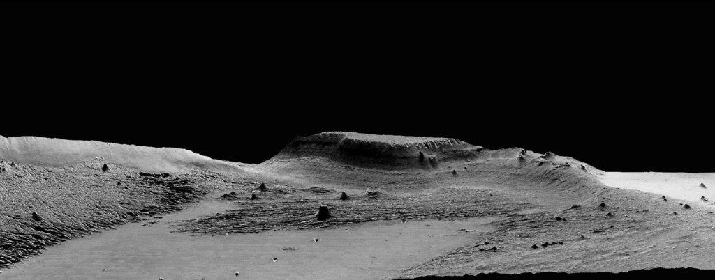
A 13-kilometer (8-mile) diameter crater being infilled by the Medusae Fossae Formation. Credit: High Resolution Stereo Camera/European Space Agency.
Scientists first observed the Medusae Fossae Formation (MFF) in the 1960s, thanks to the efforts of the Mariner spacecraft. This massive deposit of soft, sedimentary rock extends for roughly 1,000 km (621 mi) along the equator and consists of undulating hills, abrupt mesas, and curious ridges (aka. yardangs) that appear to be the result of wind erosion. What’s more, an unusual bump on top of this formation also gave rise to a UFO conspiracy theory.
Needless to say, the formation has been a source of scientific curiosity, with many geologists attempting to explain how it could have formed. According to a new study from Johns Hopkins University, the region was the result of volcanic activity that took place on the Red Planet more than 3 billion years ago. These findings could have drastic implications for scientists’ understanding of Mars’ interior and even its past potential for habitability.
Perspective view of Medusa Fossae looking south-east. Copyright: ESA/DLR/FU Berlin (G. Neukum)
Ojha’s past work includes finding evidence that water on Mars occurs in seasonal brine flows on the surface, which he discovered in 2010 as an undergraduate student. Lewis, meanwhile, has dedicated much of his academic carreer to the in-depth study of the nature of sedimentary rock on Mars for the sake of determining what this geological record can tell us about that planet’s past climate and habitability.
As Ojha explained, the study of the Medusa Fossae Formation is central to understanding Mars geological history. Much like the Tharsus Montes region, this formation was formed at a time when the planet was still geologically active. “This is a massive deposit, not only on a Martian scale, but also in terms of the solar system, because we do not know of any other deposit that is like this,” he said.
Basically, sedimentary rock is the result of rock dust and debris accumulating on a planet’s surface and becoming hardened and layered over time. These layers serve as a geological record, indicating what types of processes where taking place on the surface at the time that the layers were deposited. When it comes to the Medusae Fossae Formation, scientists were unsure whether wind, water, ice or volcanic eruptions were responsible for the deposits.
In the past, radar measurements were made of the formation that suggested that Medusae Fosssae had an unusual composition. However, scientists were unsure whether the formation was made of highly porous rock or a mixture of rock and ice. For the sake of their study, Ojha and Lewis used gravity data from various Mars orbiters to measure the formation’s density for the first time.
An isolated hill in the Medusae Fossae Formation. The effect of wind erosion on this hill is evident by its streamlined shape. Credit: High Resolution Stereo Camera/European Space Agency
What they found was that the rock is unusually porous and about two-thirds as dense as the rest of the Martian crust. They also used radar and gravity data to show that the Formation’s density was too great to be explained by the presence of ice. From this, they concluded that the heavily-porous rock had to have been deposited by volcanic eruptions when Mars was still geologically active – ca. 3 billion years ago.
As these volcanoes exploded, casting ash and rock into the atmosphere, the material would have then fallen back to the surface, building up layers and streaming down hills. After enough time, the ash would have cemented into rock, which was slowly eroded over time by Martian winds and dust storms, leaving the Formation scientists see there today. According to Ojha, these new findings suggest that Mars’ interior is more complex than previously thought.
While scientists have known for some time that Mars has some volatiles – i.e. water, carbon dioxide and other elements that become gas with slight increases in temperature – in its crust that allow for periodic explosive eruptions to occur on the surface, the kind of eruption needed to create the Medusa Fossae region would have been immense. This indicates that the planet may have massive amounts of volatiles in its interior. As Ojha explained:
“If you were to distribute the Medusae Fossae globally, it would make a 9.7-meter (32-foot) thick layer. Given the sheer magnitude of this deposit, it really is incredible because it implies that the magma was not only rich in volatiles and also that it had to be volatile-rich for long periods of time.”
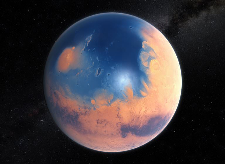
According to Ojha and Lewis’ study, the eruption that created the Medusa Fossae Formation would have covered Mars in a global ocean. Image: ESO/M. Kornmesser, via N. Risinger
In addition, this activity would have had a drastic impact on Mars’ past habitability. Basically, the formation of the Medusae Fossae Formation would have occurred during a pivotal point in Mars’ history. After the eruption occurred, massive amounts of carbon dioxide and (most likely) methane would have been ejected into the atmosphere, causing a significant greenhouse effect.
In addition, the authors indicated that the eruption would have ejected enough water to cover Mars in a global ocean more than 9 cm (4 inches) in thickness. This resulting greenhouse effect would have been enough to keep Mars’ surface warm to the point that the water would remain in a liquid state. At the same time, the expulsion of volcanic gases like hydrogen sulfide and sulfur dioxide would have altered the chemistry of Mars’ surface and atmosphere.
All of this would have had a drastic impact on the planet’s potential habitability. What’s more, as Kevin Lewis indicated, the new study shows that gravity surveys have the potential to interpret Mars’ geological record. “Future gravity surveys could help distinguish between ice, sediments and igneous rocks in the upper crust of the planet,” he said.
Studying Mars surface features and geological history is a lot like peeling an onion. With every layer we peel back, we get another piece of the puzzle, which together adds up to a rich and varied history. In the coming years and decades, more robotic missions will be studying the Red Planet’s surface and atmosphere in preparation for an eventual crewed mission by the 2030s.
All of these missions will allow us to learn more about Mars warmer, wetter past and whether or not may have existed there at some time (or perhaps, still does!)
Earth's Hadean Eon is a bit of a mystery to us, because geologic evidence from that time is scarce. Researchers at the Australian National University have used tiny zircon grains to get a better picture of early Earth. Credit: NASA
It might seem unlikely, but tiny grains of minerals can help tell the story of early Earth. And researchers studying those grains say that 4.4 billion years ago, Earth was a barren, mountainless place, and almost everything was under water. Only a handful of islands poked above the surface.
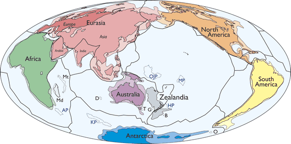
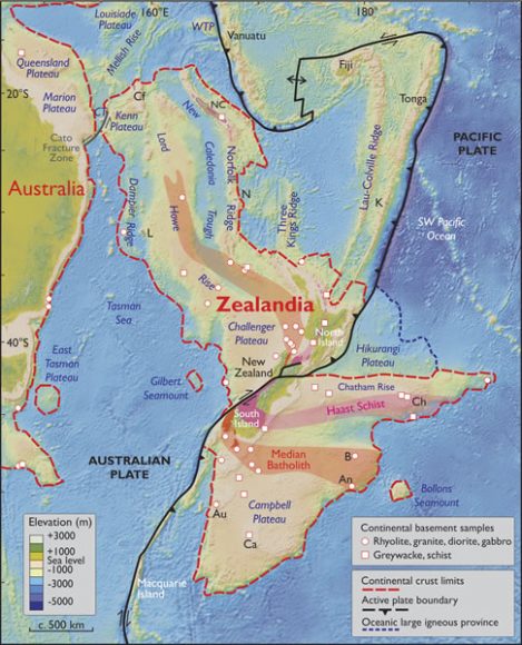
This simplified map of the continents shows the new continent Zealandia in grey. Image: Mortimer et. al. 2017, GSA Today.
We tend to lump New Zealand and Australia together. They’re similar culturally and share the same geographical position, relative to North America and Europe, anyway. But according to a new paper published in the Geological Society of America Today, it looks like New Zealand and their neighbor New Caledonia are actually their own continent: ‘Zealandia.’
Continent means something different to geographers and geologists. To be considered a geological continent, like Zealandia, the area in question has to satisfy a few conditions:
the land in question has to be higher than the ocean floor
it has to include a broad range of siliceous igneous, metamorphic, and sedimentary rocks
it has to have thicker crust than the ocean floor that surrounds it
it has to have well-defined limits, and be large enough to be considered a continent
In Geology, the first three points are well-understood. But as the authors say in the introduction to their paper, “…the last point—how “major” a piece of continental crust has to be to be called a continent—is almost never discussed… .” Since the Earth has so many micro-continents and continental fragments, defining how large something has to be to be called a continent is challenging. But the researchers did their homework.
They noted that the term “Zealandia” has been used before to describe New Zealand and surrounding regions. But the boundaries were never fully explored. 94% of this new continent is submerged, which helps explain why it’s taken this long to be identified.
This map shows the spatial limits of Zealandia. Note the dotted red line that delineates continental crust from ocean crust. Zealandia is also bisected by a plate boundary between the Pacific Plate and the Australian Plate. Image: Mortimer et. al. 2017, GSA Today
Zealandia seemed to be a collection of broken pieces, but new data collected over the years has challenged that interpretation. Recent satellite data has given us new gravity and elevation maps of the seafloor. This data has shown that Zealandia is a unified region large as large as India.
“This is not a sudden discovery but a gradual realization; as recently as 10 years ago we would not have had the accumulated data or confidence in interpretation to write this paper.”
As the authors point out in their paper, it took a while to determine that Zealandia is a continent. There was no Eureka moment. “This is not a sudden discovery but a gradual realization; as recently as 10 years ago we would not have had the accumulated data or confidence in interpretation to write this paper.”
Besides satisfying our intellectual curiosity about our planet, the discovery is important for other reasons. A proper understanding of the plate structures and continental boundaries is important to other sciences, and may trigger further understandings that we can’t predict yet. It may also point to other areas of research.
Also, many treaties rely on the agreed upon delineation of maritime and continental boundaries, including rights to fish stocks and underground resources. While the recognition of Zealandia seems clear from a scientific standpoint, it remains to be seen if it will be accepted politically.
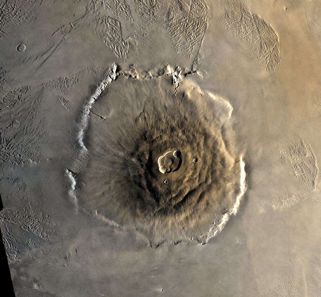
Olympus Mons on Mars is the largest volano in our Solar System. Analysis of a Martian meteorite that fell to Earth in 2012 confirms that Mars also has the longest-lived volcanoes in our Solar System. Image: NASA/JPL
Mars is renowned for having the largest volcano in our Solar System, Olympus Mons. New research shows that Mars also has the most long-lived volcanoes. The study of a Martian meteorite confirms that volcanoes on Mars were active for 2 billion years or longer.
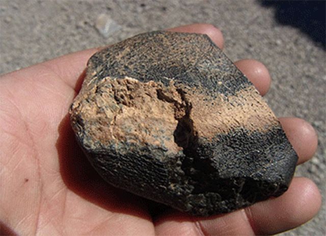
A lot of what we know about the volcanoes on Mars we’ve learned from Martian meteorites that have made it to Earth. The meteorite in this study was found in Algeria in 2012. Dubbed Northwest Africa 7635 (NWA 7635), this meteorite was actually seen travelling through Earth’s atmosphere in July 2011.
A sample from the meteorite Northwest Africa 7635. Image: Mohammed Hmani
The lead author of this study is Tom Lapen, a Geology Professor at the University of Houston. He says that his findings provide new insights into the evolution of the Red Planet and the history of volcanic activity there. NWA 7635 was compared with 11 other Martian meteorites, of a type called shergottites. Analysis of their chemical composition reveals the length of time they spent in space, how long they’ve been on Earth, their age, and their volcanic source. All 12 of them are from the same volcanic source.
Mars has much weaker gravity than Earth, so when something large enough slams into the Martian surface, pieces of rock are ejected into space. Some of these rocks eventually cross Earth’s path and are captured by gravity. Most burn up, but some make it to the surface of our planet. In the case of NWA 7635 and the other meteorites, they were ejected from Mars about 1 million years ago.
“We see that they came from a similar volcanic source,” Lapen said. “Given that they also have the same ejection time, we can conclude that these come from the same location on Mars.”
Taken together, the meteorites give us a snapshot of one location of the Martian surface. The other meteorites range from 327 million to 600 million years old. But NWA 7635 was formed 2.4 billion years ago. This means that its source was one of the longest lived volcanoes in our entire Solar System.
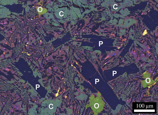
This false color X-ray of NWA 7635 shows the meteorite’s mineralogy mineral textures. O, olivine; P, plagioclase (maskelynite); C, clinopyroxene (augite). Chemical compositions: Fe (purple), Mg (green), Ca (blue), Ti (magenta), and S (yellow). Purple colors in the mesostasis represent Fe-rich augite. You’re welcome, mineral nerds. Image: Lapen et. al.
Volcanic activity on Mars is an important part of understanding the planet, and whether it ever harbored life. It’s possible that so-called super-volcanoes contributed to extinctions here on Earth. The same thing may have happened on Mars. Given the massive size of Olympus Mons, it could very well have been the Martian equivalent of a super-volcano.
The ESA’s Mars Express Orbiter sent back images of Olympus Mons that showed possible lava flows as recently as 2 million years ago. There are also lava flows on Mars that have a very small number of impact craters on them, indicating that they were formed recently. If that is the case, then it’s possible that Martian volcanoes will be visibly active again.
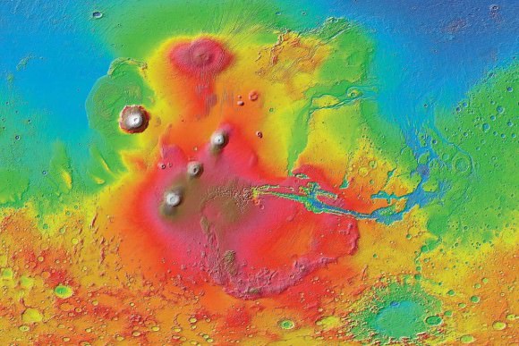
A colorized image of the surface of Mars taken by the Mars Reconnaissance Orbiter. The line of three volcanoes is the Tharsis Montes, with Olympus Mons to the northwest. Valles Marineris is to the east. Image: NASA/JPL-Caltech/ Arizona State University
Continuing volcanic activity on Mars is highly speculative, with different researchers arguing for and against it. The relatively crater-free, smooth surfaces of some lava features on Mars could be explained by erosion, or even glaciation. In any case, if there is another eruption on Mars, we would have to be extremely lucky for one of our orbiters to see it.