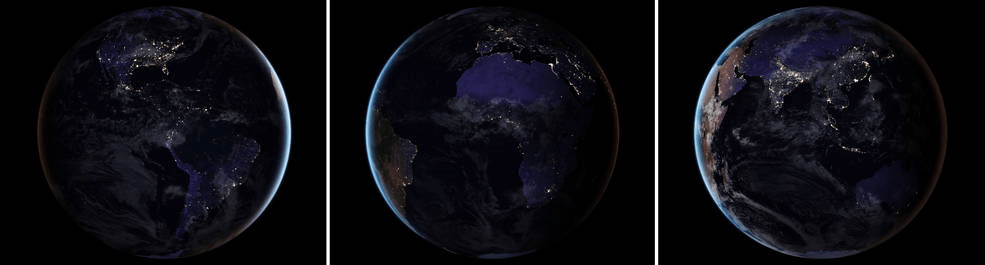
NASA strives to explore space and to expand our understanding of our Solar System and beyond. But they also turn their keen eyes on Earth in an effort to understand how our planet is doing. Now, they’re releasing a new composite image of Earth at night, the first one since 2012.
We’ve grown accustomed to seeing these types of images in our social media feeds, especially night-time views of Earth from the International Space Station. But this new image is much more than that. It’s part of a whole project that will allow scientists—and the rest of us—to study Earth at night in unprecedented detail.
Night-time views of Earth have been around for 25 years or so, usually produced several years apart. Comparing those images shows clearly how humans are changing the face of the planet. Scientists have been refining the imaging over the years, producing better and more detailed images.
The team behind this is led by Miguel Román of NASA’s Goddard Space Flight Center. They’ve been analyzing data and working on new software and algorithms to improve the quality, clarity, and availability of the images.
This new work stems from a collaboration between the National Oceanic and Atmospheric Administration (NOAA) and NASA. In 2011, NASA and NOAA launched a satellite called the Suomi National Polar-orbiting Partnership (NPP) satellite. The key instrument on that satellite is the Visible Infrared Imaging Radiometer Suite (VIIRS), a 275 kg piece of equipment that is a big step forward in Earth observation.
VIIRS detects photons of light in 22 different wavelengths. It’s the first satellite instrument to make quantitative measurements of light emissions and reflections, which allows researchers to distinguish the intensity, types and the sources of night lights over several years.
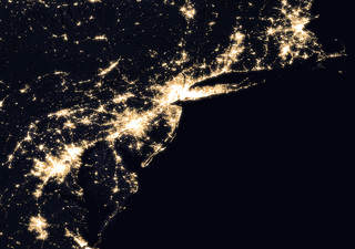
Credits: NASA Earth Observatory images by Joshua Stevens, using Suomi NPP VIIRS data from Miguel Román, NASA’s Goddard Space Flight Center
Producing these types of maps is challenging. The raw data from SUOMI NPP and its VIIRS instrument has to be skillfully manipulated to get these images. The main challenge is the Moon itself.
As the Moon goes through its different phases, the amount of light hitting Earth is constantly changing. Those changes are predictable, but they still have to be accounted for. Other factors have to be managed as well, like seasonal vegetation, clouds, aerosols, and snow and ice cover. Other changes in the atmosphere, though faint, also affect the outcome. Phenomenon like auroras change the way that light is observed in different parts of the world.
The newly released maps were made from data throughout the year, and the team developed algorithms and code that picked the clearest night views each month, ultimately combining moonlight-free and moonlight-corrected data.
The SUOMI NPP satellite is in a polar orbit, and it observes the planet in vertical swaths that are about 3,000 km wide. With its VIIRS instrument, it images almost every location on the surface of the Earth, every day. VIIRS low-light sensor has six times better spatial resolution for distinguishing night lights, and 250 times better resolution overall than previous satellites.
What do all those numbers mean? The team hopes that their new techniques, combined with the power of VIIRS, will create images with extraordinary resolution: the ability to distinguish a single highway lamp, or fishing boat, anywhere on the surface of Earth.
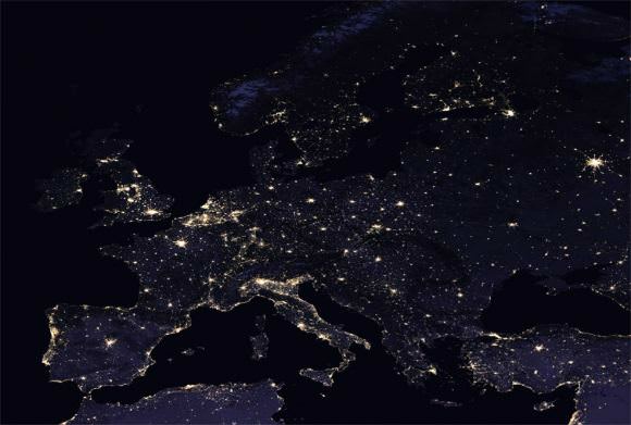
Credits: NASA Earth Observatory images by Joshua Stevens, using Suomi NPP VIIRS data from Miguel Román, NASA’s Goddard Space Flight Center
Beyond thought-provoking eye-candy for the rest of us, these images of night-time Earth have practical benefits to researchers and planners.
“Thanks to VIIRS, we can now monitor short-term changes caused by disturbances in power delivery, such as conflict, storms, earthquakes and brownouts,” said Román. “We can monitor cyclical changes driven by reoccurring human activities such as holiday lighting and seasonal migrations. We can also monitor gradual changes driven by urbanization, out-migration, economic changes, and electrification. The fact that we can track all these different aspects at the heart of what defines a city is simply mind-boggling.”
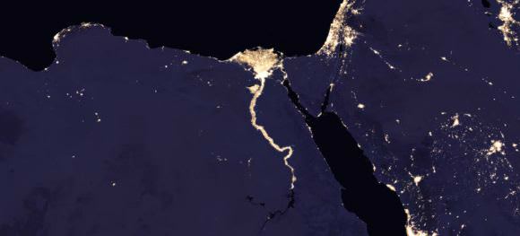
Credits: NASA Earth Observatory images by Joshua Stevens, using Suomi NPP VIIRS data from Miguel Román, NASA’s Goddard Space Flight Center
These maps of night-time Earth are a powerful tool. But the newest development will be a game-changer: Román and his team aim to provide daily, high-definition views of Earth at night. Daily updates will allow real-time tracking of changes on Earth’s surface in a way never before possible.
Maybe the best thing about these upcoming daily night-time light maps is that they will be publicly available. The SUOMI NPP satellite is not military and its data is not classified in any way. They hope to have these daily images available later this year. Once the new daily light-maps of Earth are available, it’ll be another powerful tool in the hands of researchers and planners, and the rest of us.
These maps will join other endeavours like NASA-EOSDIS Worldview. Worldview is a fascinating, easy-to-use data tool that anyone can access. It allows users to look at satellite images of the Earth with user-selected layers for things like dust, smoke, draught, fires, and storms. It’s a powerful tool that can change how you understand the world.