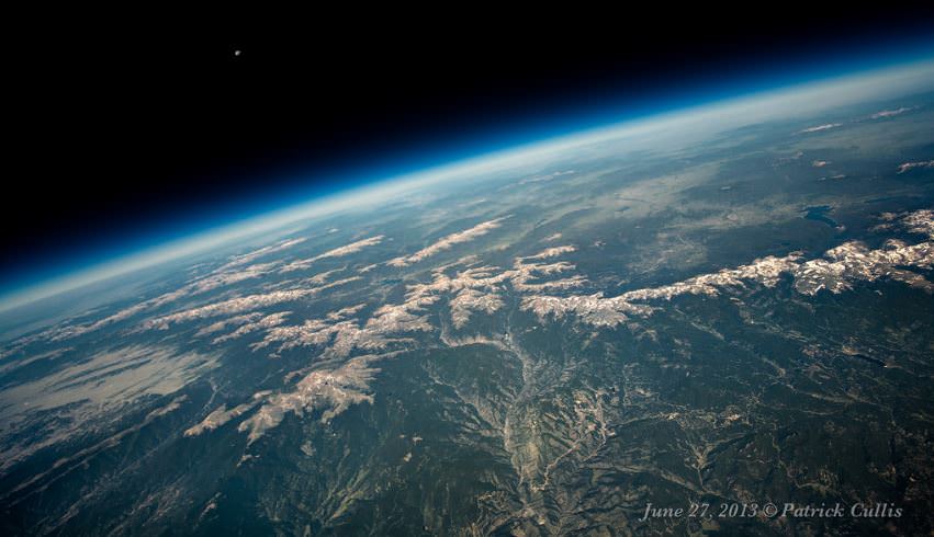
The Moon sets above the Continental Divide in Colorado from 86,000 feet. Taken June 27, 2013 on a meteorological balloon launched from Boulder, Colorado. Credit and copyright: Patrick Cullis.
I love those images taken from the International Space Station that show the Moon rising or setting above Earth’s limb, and when I first saw this image posted on Universe Today’s Flickr Group page, I thought someone had randomly posted one of those images taken by an astronaut on the ISS. But then I saw it was taken by Patrick Cullis, one of our “regulars” in our featured astrophotography posts.
This very beautiful, crisp and clear image was taken from a meteorological balloon at 86,000 feet (26,200 meters) above Earth, and it was no fluke that Patrick captured the Moon setting above Earth — it was planned.
“Once I knew the weather was going to work out for a launch I really planned out what time it needed to happen for the Moon to show up in the frame,” Patrick said via Flickr. “Definitely got lucky since the camera is just swinging around randomly under the balloon.”
He calls this image “Divided Moon,” as it shows the Continental Divide in Colorado. “I-70 can be seen snaking up from the bottom center towards Georgetown (valley stretching from left to right,) Loveland Pass, and the Eisenhower Tunnel,” Patrick explained. If you click on the image above (or go here to see it on Flickr) you can see other landmarks labeled.
This is an article from our archive, but we’ve updated it with this spiffy video.
Every now and then I go looking for a free aerial view of my home. It’s amazing what’s available through the internet now, totally free. Thanks to commercial Earth observation satellites, and internet tools that make these photos accessible through the internet, it’s easy to see your house from space.
In our modern space age, there are more than 8,000 satellites currently orbiting the Earth. The vast majority of these are relaying data to and from the Earth, and many are equipped with high power cameras. Just look up into the sky any night, and you’re sure to see satellite after satellite passing overhead. But what are some ways you can get access to these satellite and aerial images of your house?
Satellite Images of the Whole Earth
If you want to go way out and just see a satellite image of the entire planet, there are some solutions for you: weather satellites. For example, NOAA’s Geostationary Operational Environmental Satellites (GOES) release images of an entire hemisphere of planet Earth every 3 hours. From these images you can see major weather patterns affecting parts of the Earth. But you really can’t see any specific spot on Earth with any detail.
What is really cool about these satellite views is that they’re live. The weather systems you’re seeing in those images are happening on the planet right now.
If you don’t want a live view, and really just want to see a beautiful view of the Earth’s hemisphere, check out these images produced by NASA. Here’s a composite photograph that shows the Earth’s Western Hemisphere, and here’s a view of the Earth’s Eastern Hemisphere.
Zoom in. Let’s see Satellite Pictures of Houses
If those whole Earth pictures don’t give you enough detail, let’s zoom in, and see some pictures of houses from space. The best tool on the market, in my opinion, is the service from Google Maps. All you need is a web browser and a connection to the internet. When you first start up, Google Maps displays a satellite view of North America. You can then zoom in, or pan the camera around to see any location on Earth. You can also type in the address of the location that you want to see. Once you do that, you’ll get a free satellite view of your house. You can save the image or print it off.
Another cool tool from Google is Google Earth. You can access by going to http://earth.google.com. The main difference between Google Maps and Google Earth is that you have to download and install Earth on your local computer (they have a version for PCs, Mac, Linux, and even the iPhone). Once you’ve downloaded and installed Google Earth, you can see a 3-dimensional view of Earth that you can zoom in and out and spin around. You can type in your address and get a view of your house from above. I actually like the printing function of Google Earth better, since it’s using your printer directly, and not going through the web browser.
And if you really hate using products from Google, no problem. There are similar services from Yahoo and Microsoft. Microsoft’s mapping service used to be called MSN Maps, and now it’s been changed to Bing Maps with their new identity. The Yahoo service is called Yahoo Maps, and it’s very similar to Google Maps. The two services do have some big differences, though, and there’s a cool application that lets you see the two of them side-by-side. I used it for my home and found that Google Maps has better resolution maps for my city.
Where Do All these Pictures Come From?
Google Maps and the other internet mapping services are really just customers for the satellite services that actually take these photographs from space. There are a few major services on the market, including GeoEye. GeoEye’s main competitors include DigitalGlobe and Spot Image.
Each company has a fleet of Earth observation satellites, with a capability of resolving features on the surface of the Earth as small as about 45 cm (18 inches). In other words, an object 45 centimeters across would appear as a single pixel in their photographs.
Each of these services allow customers to purchase satellite imagery directly, but I’ll warn you, the prices are extremely high: hundreds or even thousands of dollars for satellite imagery. You typically can’t buy directly from the satellite company itself, but through their international partners.It’s better to stick to the free sources.
Are These Live Satellite Views?
When you look at these amazing views of your house from space, you might wonder if this is live. If you walk outside and look up, will you be able to see yourself from space? Unfortunately, no. All of the free satellite images you’re accessing were captured by various spacecraft over the last couple of years.
You can actually get a pretty good sense of when the picture was taken by the image of your property. For example, in the photo of my house from space, I can see a car that I sold a couple of years ago. Obviously, this image isn’t live, it’s at least a couple of years old – even a decade old in some cases. A live satellite view of your house, is still a few years off.
There are some services which will give you a live view of Earth from space. For example, you can access a live broadcast from NASA’s International Space Station. About 40% of the time, if you follow this link you can see a live view of Earth from the space station. Another service called Urthecast will be attaching a high definition camera to the International Space Station in 2013 to broadcast a live view of Earth from space.
Click for a larger version of this image to see if you can see the Pyramids at Giza from the International Space Station. Via astronaut Nicole Stott's Twitpic feed.
[/caption]
Astronaut Nicole Stott posted this image on her Twitter account. If you can spot the Great Pyramids at Giza in this small image, you’ve pretty good eyesight! Click the image for a larger version if can’t find them.
Astronaut Soichi Noguchi posted an image of different set of pyramids at Dahshur, Egypt, from his stint on the ISS in 2010. He zoomed in a little more, making them easier to see, below:
The Red Pyramid and the Bent Pyramid in Dahshur, Egypt. Credit: Soichi Noguchi/NASA/JAXA
Looking for a picture of Earth from Space? Here is a collection.
[/caption]
Here’s a spectacular image of the earth with the full coverage of the Pacific Ocean. This image was obtained by the Galileo spacecraft on December 12, 1990 while on its way to planet Jupiter 1.6 million miles from the Earth.
The Blue Marble from Apollo 17
This is a spectacular full view of our planet earth. It was taken by the Apollo 17 during their journey to the moon in December 7, 1972. The south polar ice cap of Antarctica can be clearly seen in the image. This region constitutes 70% of the world’s freshwater. This photo of the earth was the first to feature the south polar ice cap.
A Stormy Atlantic
Here’s an image of different storms and hurricanes forming at the Atlantic Ocean. This image was generated using the data provided by the Geostationary Operational Environmental Satellite (GOES) satellite on September 3, 2008.
Earth - Western Hemisphere
Here’s a nice view of the earth particularly focusing on the Western Hemisphere. Earth is the third planet from the sun and is the only place in the universe where life is known to exist.
The Earth-Moon System
This is a nice view of the planet earth and the moon in one frame as seen from the Galileo spacecraft 6.2 million kilometers away.
Picture of Earth from Space
Here’s a picture of Earth from Space as well as the Moon. These images were taken separately and then stitched together on computer to show them together.
Earth from Space
This picture was taken by the Space Shuttle, and shows the Earth from high orbit. You can see how the clouds rise up into the atmosphere.
Earth from space
Here’s another picture of Earth. Again, this was taken from the space shuttle.
NASA satellite map of the Earth
This is a satellite map that shows all of the Earth.
This is the classic “Blue Marble” photo of Earth.
Earth from Space at Night
Earth from Space at Night
Here’s a photo of the entire Earth, seen from space at night. You can easily see cities and towns in North America, Asia and Europe. And you can also see vast regions of the Earth which are totally dark.
Chicago at night
Here’s a photo of the city of Chicago at night. It might look upside down, but that’s because it was captured from the International Space Station as it was passing over the city.
Tokyo at night
This night space image shows the city of Tokyo at night. The blue green glow in the photograph comes from the mercury vapor lighting that lines the streets of the city.
London at night
This space pic from night shows the city of London. You can see the brightest areas are the most densely populated, and the less dense areas are dimmer. You can see the ring road that surrounds London, as well as the path of the Thames river.
Los Angeles at night
Here’s one of the brightest cities in the world. It’s Los Angeles from space, seen at night.
A Crescent Earth at Midnight
Here’s an amazing picture of the earth in crescent. This breathtaking view of our planet was obtained by the Geostationary Operational Environmental Satellite (GOES-8) on June 22, 1996. GOES is primarily assigned in monitoring the weather particularly the development of storms and hurricanes in different parts of the earth.
Earth at Twilight
This is an amazing still photo of the earth taken during its transition from day to night. This beautiful photo was taken from the International Space Station in June 2001.
All Is Illuminated
This spectacular image of the crescent earth was captured by the Optical Spectroscopic and Infrared Remote Imaging System (OSIRIS) camera on board the Rosetta spacecraft in November 2007.
Houston, Texas at Night
Here’s a nice view of Houston, Texas at night as seen from the International Space Station on February 28, 2010. This photo was taken by the crew member of the Expedition 22 mission. Houston, Texas is the world’s energy capital.
Earth from Orbit
Manicouagan Reservoir. Credit: NASA
Here’s an image of the Manicougan Reservoir situated at Canadian Shield in the province of Quebec. This was taken from the International Space Station in December 1983. Manicougan Reservoir covers an area of about 1,942 km².
Sunset
This image of the sunset on earth was captured from the International Space Station by an Expedition 13 astronaut in August 10, 2006. Expedition 13 mission was able to accomplish a total of 2,886 orbits.
Expedition 11 Earth Observation Photos
This photo shows the Central Gulf Coast obtained from the International Space Station by an Expedition 11 astronaut in September 10, 2005.
Into the Eye of the Storm
This is a photo of the eye of Hurricane Alberto taken in August 19, 2000 during the Terra orbit 3571. Hurricane Alberto is a Category 3 hurricane in the Atlantic that lasted for 19.75 days.
Hurricane Emily and the Moon
This beautiful view of the eye of Hurricane Emily and the moon was captured from the International Space Station in July 16, 2005. Hurricane Emily is a Category 5 hurricane having a maximum wind speed of 160 mph.
Earth from the Space Shuttle
Sunrise in Space
This photo of the earth’s atmosphere during sunrise was taken in July 2005 by a Discovery crew member during the STS-114 mission. STS-114 mission was the first Return to Flight mission after the unfortunate loss of the Columbia space shuttle.
Onboard View - Space Shuttle Endeavour
This image of the earth was taken from the space shuttle Endeavor during the STS-59 mission in April 12, 1994. The image particularly shows the shuttle’s payload bay and the region of the Andes Mountains in Bolivia.
Sinai Peninsula and the Mediterranean Sea
Here’s a stunning image of the Sinai Peninsula and the Mediterranean Sea as seen from the space shuttle Atlantis. A crew member of the STS-125 mission took this photo during the mission’s first flight in space.
View of the Journey Home
Here’s a unique photo of the earth’s atmosphere taken by the crew members of Atlantis’ STS-125 mission during its preparation for landing on May 20, 2009.
STS-39 view of the Aurora Australis
Here’s a great view of the Aurora Australis taken in May 1991 by the STS-39 crew member onboard the space shuttle.
Here are some cool pictures of islands… from space!
[/caption]
This is a picture of South Georgia Island, one of the southernmost islands in the world, off the tip of South America. It was used as a whaling base and now has no permanent inhabitants, other than some scientists. In this picture, taken by NASA’s Terra satellite, the entire island is covered in snow. Here are some more island pictures.
Surtsey Island
This is a picture of Surtsey Island, captured by the IKONOS satellite. This volcanic island is one of the newest in the world, breaking through the surface of the ocean in 1963. The volcanoes that formed the island erupted for about 4 years and then stopped, and now erosion from the ocean is wearing it back down again.
Ascension Island
Next in our pictures of islands is Ascension Island. You can see the airstrip down on the lower right side of the island, and a cinder cone above it. The northern part of the island has lava flows and you can see individual clouds above the island. Ascension Island is one of the space shuttle’s alternative landing sites.
Palm Island
Here’s a picture of a completely man made island. This is Palm Island, off the coast of Dubai in the United Arab Emirates. Now complete, it has palm fronds surrounded by a circular breakwater. There will eventually be more than 100 luxury hotels, marinas, water theme parks, and many houses.
Akpatok Island
This is a picture of Akpatok Island, in Northern Quebec, which is accessible only by air. The picture was taken by a Landsat satellite.


