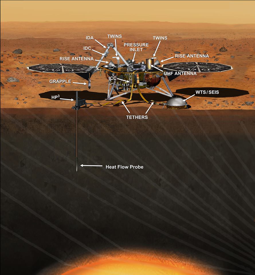
This artist's concept depicts the InSight lander on Mars after the lander's robotic arm has deployed a seismometer and a heat probe directly onto the ground. InSight is the first mission dedicated to investigating the deep interior of Mars. The findings will advance understanding of how all rocky planets, including Earth, formed and evolved. NASA approved a new launch date in May 2018. Credits: NASA/JPL-Caltech
NASA managers have just made the difficult but unavoidable decision to scrub the planned March 2016 launch of the InSight lander, the agency’s next mission to Mars, by at least two years because of a vacuum leak that was just detected in the probes flawed seismometer instrument which cannot be fixed in time.
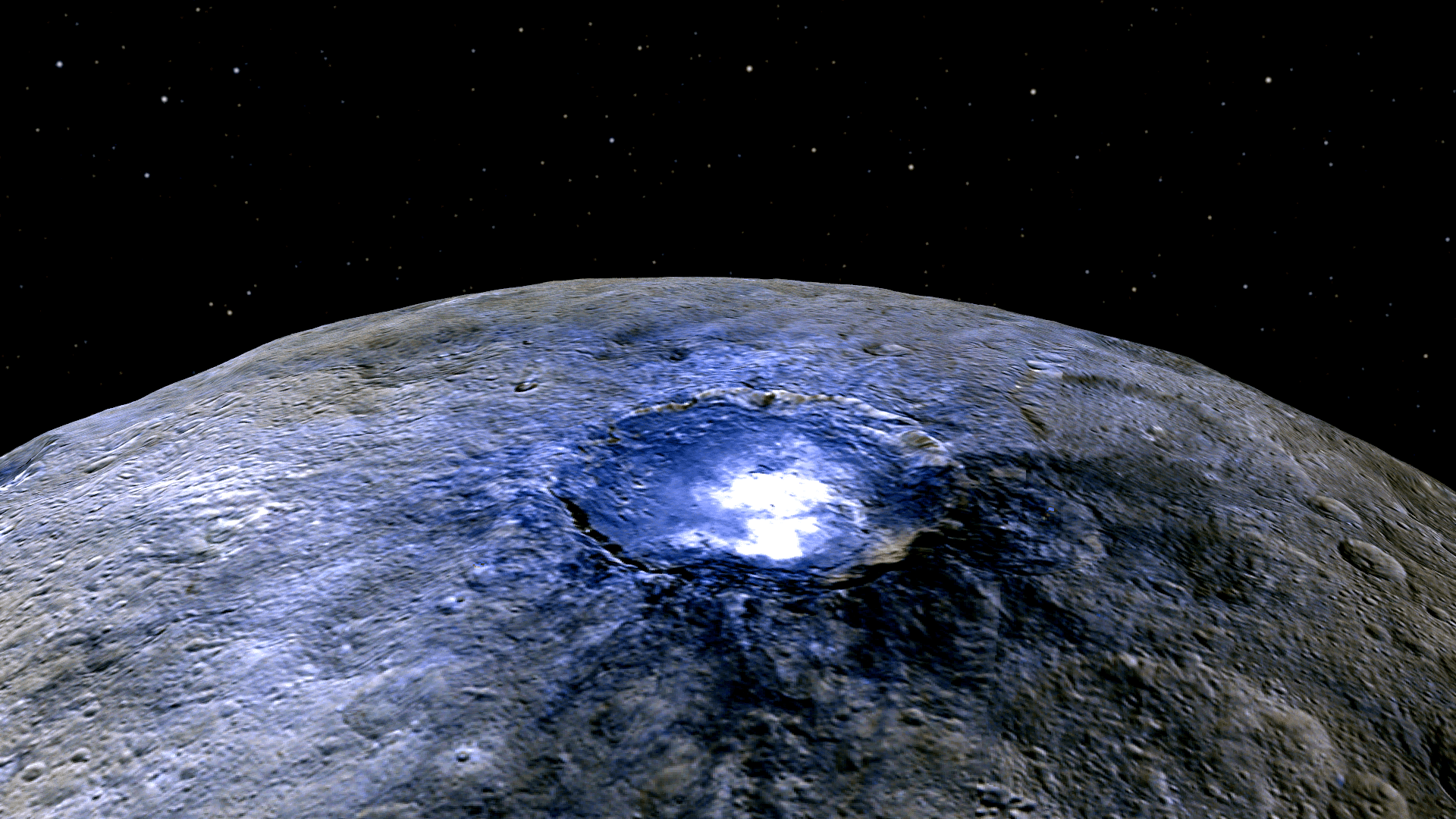
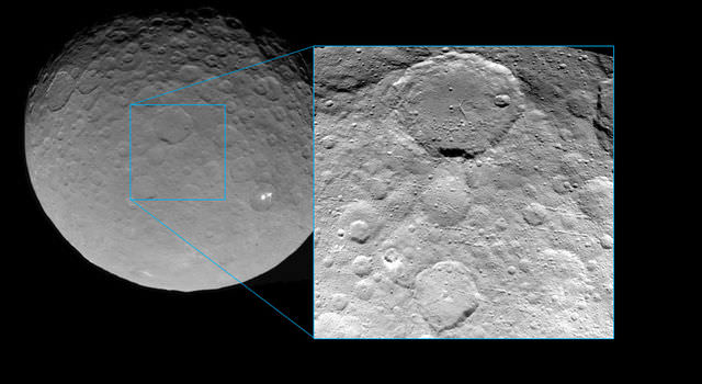
This representation of Ceres' Occator Crater in false colors shows differences in the surface composition. Red corresponds to a wavelength range around 0.97 micrometers (near infrared), green to a wavelength range around 0.75 micrometers (red, visible light) and blue to a wavelength range of around 0.44 micrometers (blue, visible light). Occator measures about 60 miles (90 kilometers) wide. Credits: NASA/JPL-Caltech/UCLA/MPS/DLR/IDA
This representation of Ceres’ Occator Crater in false colors shows differences in the surface composition. Red corresponds to a wavelength range around 0.97 micrometers (near infrared), green to a wavelength range around 0.75 micrometers (red, visible light) and blue to a wavelength range of around 0.44 micrometers (blue, visible light). Occator measures about 60 miles (90 kilometers) wide. Credits: NASA/JPL-Caltech/UCLA/MPS/DLR/IDA
With NASA’s Dawn spacecraft set to enter its final and lowest orbit around the dwarf planet Ceres, spectral measurements are enabling researchers to gradually unravel the nature of the numerous mysterious and intriguing bright spots recently discovered, and now they conclude that briny mixtures of ice and salts apparently reside just beneath certain patches of the pockmarked surface and that “water is sublimating” from the surface of an “active crater”.
Scene from ‘The Martian’ starring Matt Damon as NASA astronaut Mark Watney contemplating magnificent panoramic vista while stranded alone on Mars. Credits: 20th Century Fox
Scene from ‘The Martian’ starring Matt Damon as NASA astronaut Mark Watney contemplating magnificent panoramic vista while stranded alone on Mars.
Credits: 20th Century Fox
See real Martian maps and flyover video from DLR and NSA below
Story/imagery updated[/caption]
Go now and experience Hollywood’s blockbuster new space epic ‘The Martian’ helmed by world renowned director Ridley Scott and starring Matt Damon as the protagonist, NASA astronaut Mark Watney. And you can follow Watney’s dramatic fictional path across the Red Planet in newly released real photos and a flyover video of the region, from DLR and NASA, as it looks today.
‘The Martian’ is a mesmerizingly enjoyable cinematic triumph for everyone that’s all about science, space exploration and one man’s struggle to survive while left totally isolated on the Red Planet in the face of seemingly insurmountable odds – relying on his wits alone to endure “on a planet where nothing grows” while hoping somehow for a rescue by NASA four years in the future.
The movie combines compelling and plausible storytelling with outstanding special effects that’s clearly delighting huge audiences worldwide with a positive and uplifting view of what could be achieved in the future – if only we really put our minds to it!
Based on the bestselling book by Andy Weir, ‘The Martian’ movie from 20th Century Fox tells the spellbinding story of how NASA astronaut Mark Watney is accidentally stranded on the surface of Mars during the future Ares 3 manned expedition in 2035, after a sudden and unexpectedly fierce dust storm forces the rest of the six person crew – commanded by Jessica Chastain as Commander Lewis – to quickly evacuate after they believe he is dead.
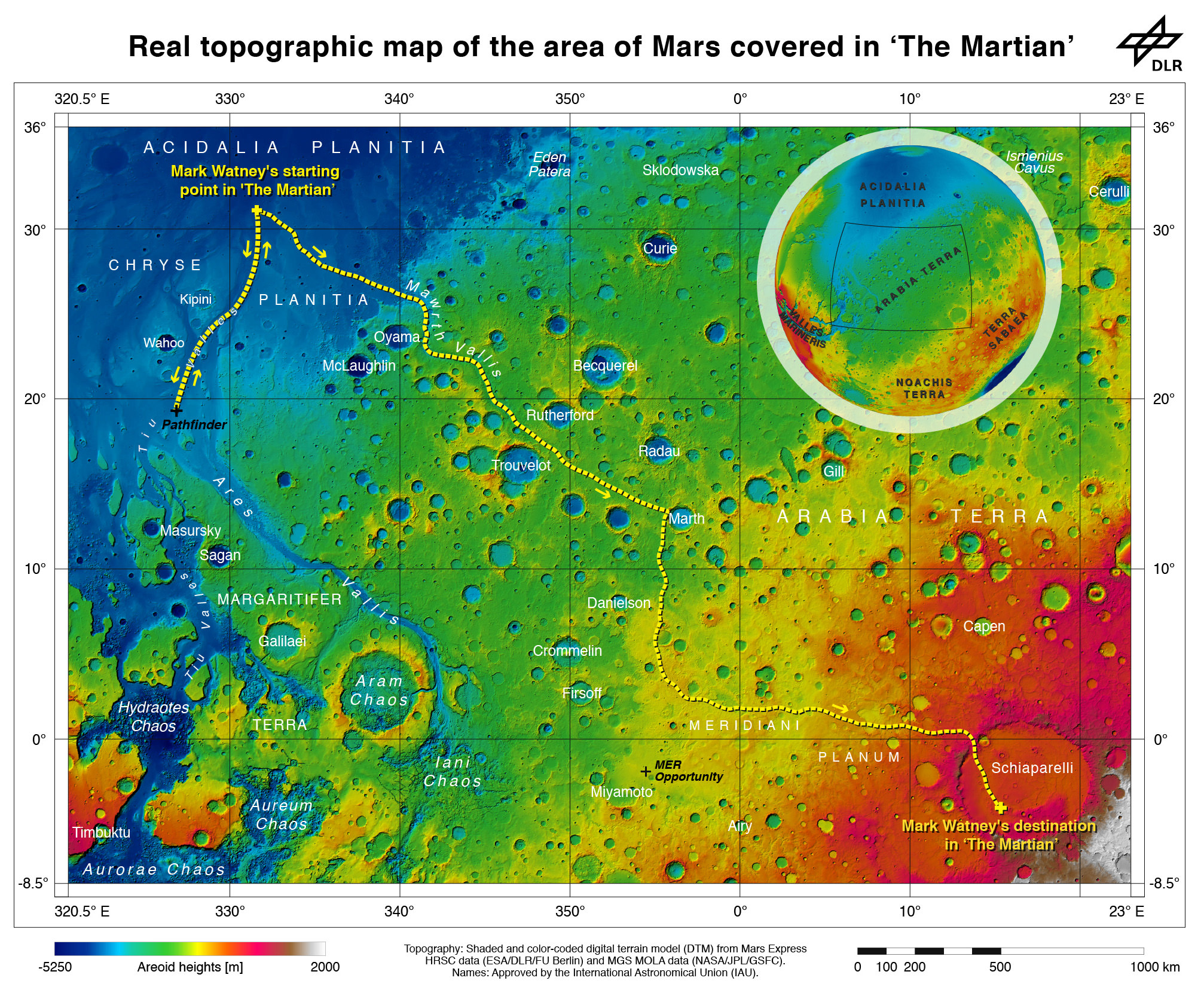
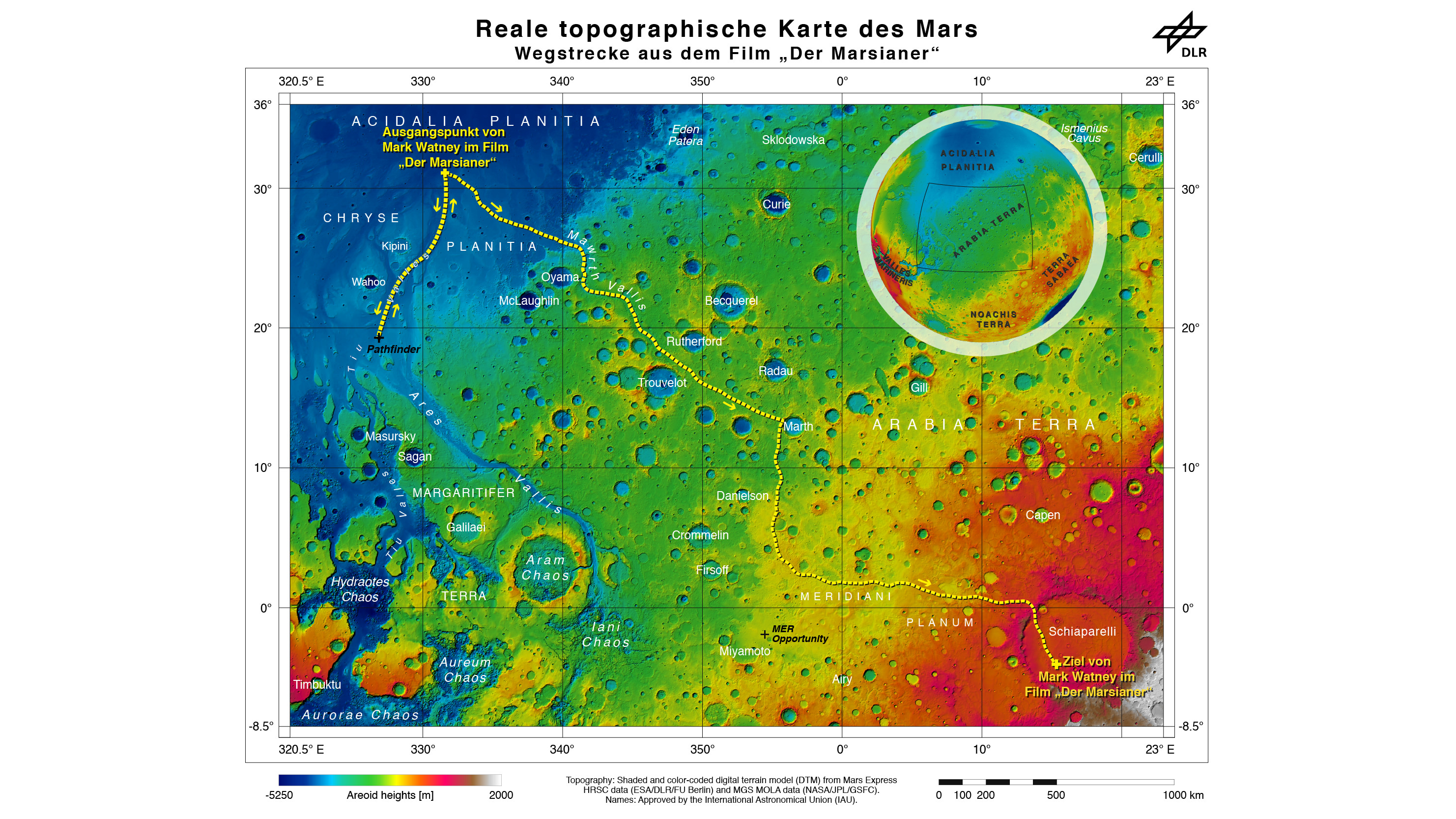
Real topographic map of the area of Mars covered in ‘The Martian.’ Follow the path of Mark Watney’s fictional endeavors from the Ares 3 landing site at Acidalia Planitia to NASA’s real Mars Pathfinder lander at the mouths of Ares Vallis and Tiu Valles and back, and finally to the Ares 4 landing site at Schiaparelli Crater. Credit: DLR/ESA/NASA
Now you can follow the fictional exploits of Mark Watney’s stunningly beautiful trail across the real Mars through a set of newly released maps, imagery and a 3D video created by the DLR, the German Aerospace Agency, and NASA – and based on photos taken by the European Space Agency’s Mars Express orbiter and NASA’s Mars Reconnaissance Orbiter (MRO).
DLR’s stunning 3D overflight video sequence was created from a dataset of 7300 stereo images covering roughly two-and-a-half million square kilometres of precisely mapped Martian landscape captured over the past 12 years by Mars Express High Resolution Stereo Camera (HRSC). The electric score is by Stephan Elgner.
Video Caption: Following the path of The Martian – video generated using images acquired by the Mars Express orbiter. Scientists from German Aerospace Center, DLR– who specialise in producing highly accurate topographical maps of Mars – reconstructed Watney’s route using stereo image data acquired by the High Resolution Stereo Camera on board European Space Agency’s #MarsExpress spacecraft. They then compiled this data into a video that shows the spectacular landscape that the protagonist would see ‘in the future’ on his trek from Ares 3 at Acidalia Planitia/Chryse Planitia to Ares 4 at Schiaparelli Crater. Credit: DLR/ESA
Ridley Scotts ‘The Martian’ takes place mostly on the surface of the Red Planet and is chock full of breathtakingly beautiful panoramic vistas. In the book you can only imagine Mars. In the movie Scott’s talents shine as he immerses you in all the action on the alien world of Mars from the opening scene.
Starting with the landing site for Watney’s Ares 3 mission crew at Acidalia Planitia, the book and movie follows his triumphs and tribulations, failures and successes as he logically solves one challenging problem after another – only to face increasingly daunting and unexpected hurdles as time goes by and supplies run low.
The DLR route map shows a real topographic view of Watney’s initial journey back and forth from the fictional Ares 3 landing site to the actual landing site of NASA’s 1997 Mars Pathfinder lander and Sojourner rover mission at the mouth of Ares Vallis.
Mark Watney arrives at the NASA’s 1997 Pathfinder lander to gather communications gear in a scene from “The Martian.” People and technology from NASA’s Jet Propulsion Laboratory aid fictional astronaut Mark Watney during his epic survival story in “The Martian.” Credits: 20th Century Fox
The map continues with Watney’s months-long epic trek to the fictional landing site of Ares 4 Mars Ascent Vehicle (MAV) spacecraft at Schiaparelli Crater, by way of Marth Valles and other Martian landmarks, craters and valleys.
At the request of Andy Weir, the HiRISE camera on NASA’s MRO orbiter took photos of the Martian plain at the Ares 3 landing site in Acidalia Planitia, which is within driving distance from the Pathfinder lander and Sojourner rover in the book and movie.
This May 2015 image from the HiRISE camera on NASA’s Mars Reconnaissance Orbiter shows a location on Mars associated with the best-selling novel and Hollywood movie, “The Martian.” It is in a region called Acidalia Planitia, at the landing site for the science-fiction tale’s Ares 3 mission. For the story’s central character, Acidalia Planitia is within driving distance from where NASA’s Mars Pathfinder, with its Sojourner rover, landed in 1997. Credits: NASA/JPL-Caltech/Univ. of Arizona
The Martian is all about how Watney uses his botany, chemistry and engineering skills to “Science the sh** out of it” to grow food and survive until the hoped for NASA rescue.
Learning how to live off the land will be a key hurdle towards enabling NASA’s real strategy for long term space voyages on a ‘Journey to Mars’ and back.
‘The Martian’ is a must see movie that broadly appeals to space enthusiasts and general audiences alike who can easily identify with Watney’s ingenuity and will to live.
Since its worldwide premiere on Oct. 2, ‘The Martian’ has skyrocketed to the top of the US box office for the second weekend in a row, hauling in some $37.3 million. The total domestic box office receipts now top $108 million and rockets to over $228 million worldwide in the first 10 days alone.
I absolutely loved ‘The Martian’ when I first saw the movie on opening weekend. And enjoyed it even more the second time, when I could pick up a few details I missed the first time around.
Matt Damon stars as NASA astronaut Mark Watney in ‘The Martian.’ Credit: 20th Century Fox
The movie begins as the crew evacuates after they believe Watney was killed by the dust storm. Watney actually survived the storm but lost contact with NASA. The film recounts his ingenious years long struggle to survive, figure out how to tell NASA he is alive and send a rescue crew before he starves to death on a planet where nothing grows. Watney’s predicament is a survival lesson to all including NASA.
‘The Martian’ was written by Andy Weir in 2010 and the film could well break the October movie box office record currently held by ‘Gravity.’
The movie closely follows the book, which I highly recommend you read at some point.
By necessity, the 2 hour 20 minute movie cannot capture every event in the book. So there is an abbreviated sense of Watney’s detailed science to survive and lengthy overland trips.
All the heroics and difficulties in traveling to Pathfinder and back and getting communications started, as well as the final month’s long journey to Schiaparelli crater are significantly condensed, but captured in spirit.
The Martian is brilliant and intelligent and rivals Stanley Kubrik’s space epic ‘2001: A Space Odyssey’ as one of the top movies about humanities space exploration quest.
The one big science inaccuracy takes place right at the start with the violent Martian dust storm.
On Mars the atmosphere is so thin that the winds would not be anywhere near as powerful or destructive as portrayed. This is acknowledged by Weir and done for dramatic license. We can look past that since the remainder of the tale portrays a rather realistic architectural path to Mars and vision of how scientists and engineers think. Plus the dust storms can in fact kick up tremendous amounts of particles that significantly block sunlight from impinging on solar energy generating panels.
Personally I can’t wait for the ‘Directors Cut’ with an added 30 to 60 minutes of scenes that were clearly filmed – but not included in the original theatrical release.
THE MARTIAN features a star studded cast that includes Matt Damon, Jessica Chastain, Kristen Wiig, Kate Mara, Michael Pena, Jeff Daniels, Chiwetel Ejiofor, and Donald Glover.
“NASA has endorsed “The Martian’” Jim Green, NASA’s Director of Planetary Sciences, told Universe Today. Green served as technical consultant on the film.
At NASA’s Kennedy Space Center in Florida agency scientists, astronauts actors from the 20th Century Fox Entertainment film “The Martian” met the media. Participants included, from the left, Center Director Bob Cabana, NASA’s Planetary Science Division Director Jim Green, Ph.D., actress Mackenzie Davis, who portrays Mindy Park in the movie, retired NASA astronaut Nicole Stott and actor Chiwetel Ejiofor, who portrays Vincent Kapoor in “The Martian.” Credit: Julian Leek
The DLR film was created by a team led by Ralf Jaumann from the DLR Institute of Planetary Research, Principal Investigator for HRSC. He believes that producing the overflight video was not just a gimmick for a science fiction film:
“Mars generates immense fascination, and our curiosity continues to grow! Many people are interested in our research, and young people in particular want to know what it is really like up there, and how realistic the idea that one day people will leave their footprints on the surface of Mars truly is. The data acquired by HRSC shows Mars with a clarity and detail unmatched by any other experiment. Only images acquired directly on the surface, for instance by rovers like Curiosity, are even closer to reality, but they can only show a small part of the planet. Thanks to this animation, we have even noticed a few new details that we had not seen in a larger spatial context. That is why we made the film – it helps everyone see what it would be like for Watney to travel through these areas… the clouds were the only creative touches we added, because, fortunately, they do not appear in the HRSC data,” according to a DLR statement.
Here’s the second official trailer for The Martian:
As a scientist and just plain Earthling, my most fervent hope is that ‘The Martian’ will inspire our young people to get interested in all fields of science, math and engineering and get motivated to become the next generation of explorers – here on Earth and beyond to the High Frontier to benefit all Mankind.
Stay tuned here for Ken’s continuing Earth and planetary science and human spaceflight news.
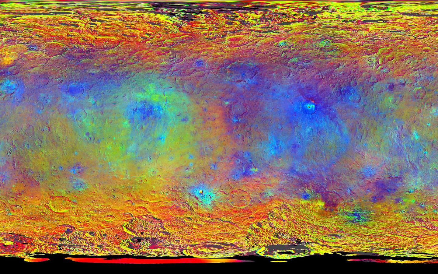
This map-projected view of Ceres was created from images taken by NASA's Dawn spacecraft during its high-altitude mapping orbit, in August and September, 2015. This color coded map can provide valuable insights into the mineral composition of the surface, as well as the relative ages of surface features. Credits: NASA/JPL-Caltech/UCLA/MPS/DLR/IDA
Slowly but surely the mysteries of dwarf planet Ceres are being peeled back layer by layer as NASA’s Dawn spacecraft orbits lower and lower and gathers detailed measurements that have now yielded global mineral and topographic maps, tantalizing researchers with the best resolution ever.
The Dawn science team has been painstakingly stitching together the spectral and imaging products captured from the lowest orbit yet achieved into high resolution global maps of Ceres, released today Sept. 30, by NASA.
“Ceres continues to amaze, yet puzzle us, as we examine our multitude of images, spectra and now energetic particle bursts,” said Chris Russell, Dawn principal investigator at the University of California, Los Angeles, in a statement.
The color coded map above is providing researchers with valuable insights into the mineral composition of Ceres surface, as well as the relative ages of the surface features that were a near total mystery until Dawn arrived on March 6, 2015.
The false-color mineral map view combines images taken using infrared (920 nanometers), red (750 nanometers) and blue (440 nanometers) spectral filters.
“Redder colors indicate places on Ceres’ surface that reflect light strongly in the infrared, while bluish colors indicate enhanced reflectivity at short (bluer) wavelengths; green indicates places where albedo, or overall brightness, is strongly enhanced,” say officials.
“Scientists use this technique in order to highlight subtle color differences across Ceres, which would appear fairly uniform in natural color. This can provide valuable insights into the mineral composition of the surface, as well as the relative ages of surface features.”
Researchers say the mineral variations at Ceres “are more subtle than on Vesta, Dawn’s previous port of call.”
The asteroid Vesta was Dawn’s first orbital target and conducted extensive observations of the bizarre world for over a year in 2011 and 2012.
The Dawn team is meeting this week to review and publish the mission results so far at the European Planetary Science Conference in Nantes, France.
Dawn is Earth’s first probe in human history to explore any dwarf planet, the first to explore Ceres up close and the first to orbit two celestial bodies.
Ceres is a Texas-sized world, ranks as the largest object in the main asteroid belt between Mars and Jupiter, and may have a subsurface ocean of liquid water that could be hospitable to life.
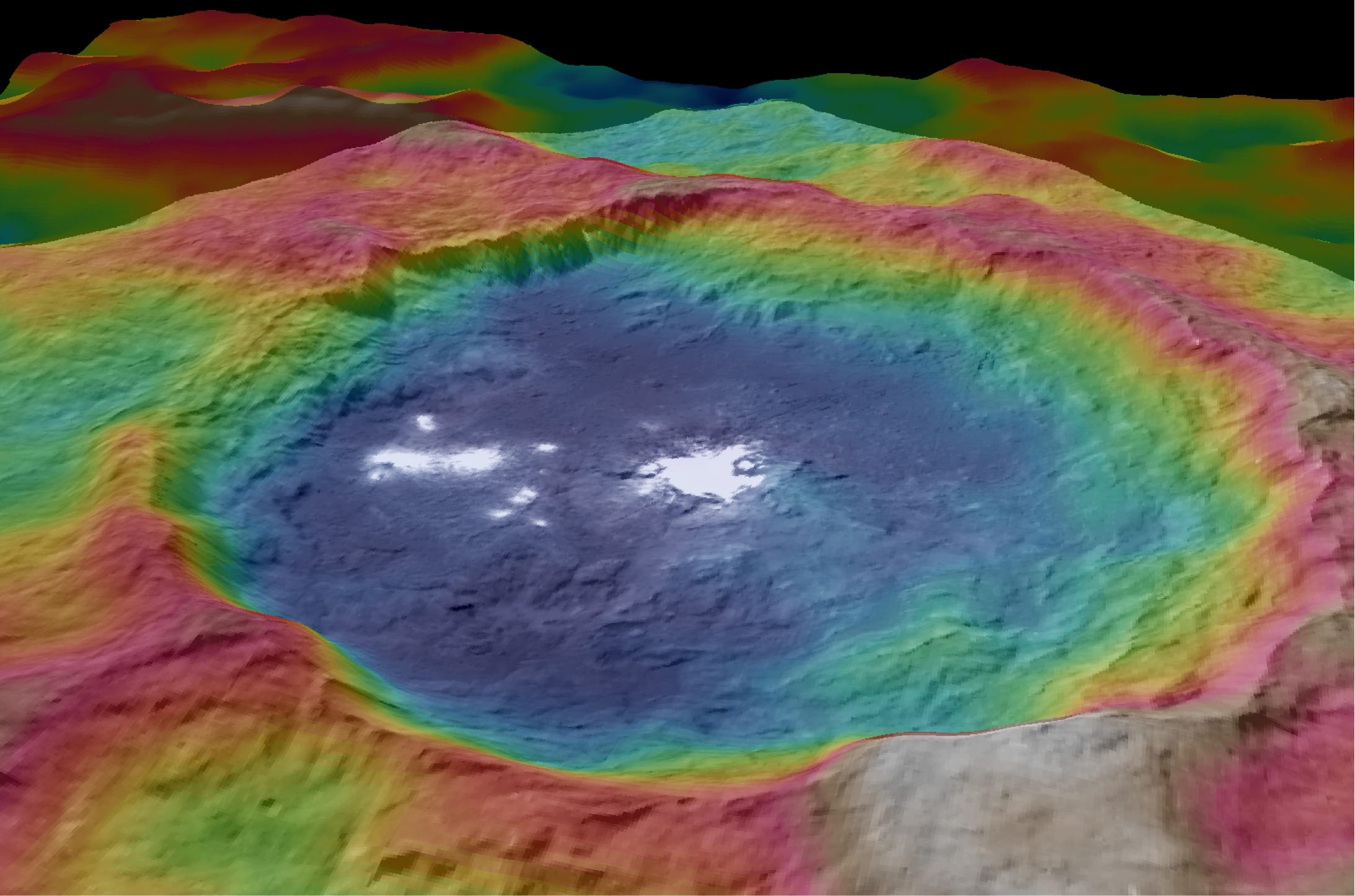
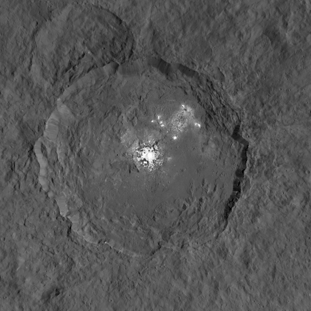
This view from NASA’s Dawn spacecraft is a color-coded topographic map of Occator crater on Ceres. Blue is the lowest elevation, and brown is the highest. The crater, which is home to the brightest spots on Ceres, is approximately 56 miles (90 kilometers wide). Credits: NASA/JPL-Caltech/UCLA/MPS/DLR/IDA
The newly released maps were created from data gathered at Dawn’s current science orbit, known as the High Altitude Mapping Orbit (HAMO) phase of the mission, during August and September.
At HAMO, Dawn is circling Ceres at an altitude of barely 915 miles (1,470 kilometers) above the heavily cratered surface.
“Dawn arrived in this third mapping orbit [HAMO] on Aug. 13. It began this third mapping phase on schedule on Aug. 17,” Dr. Marc Rayman, Dawn’s chief engineer and mission director based at NASA’s Jet Propulsion Laboratory, Pasadena, California, told Universe Today.
Each HAMO mapping orbit cycle lasts 11 days and consists of 14 orbits lasting 19 hours each. Ceres is entirely mapped during each of the 6 cycles. The third mapping cycle started on Sept. 9.
Dawn’ instruments, including the Framing Camera and Visible and Infrared Spectrometer (VIR) will be aimed at slightly different angles in each mapping cycle allowing the team to generate stereo views and construct 3-D maps.
“The emphasis during HAMO is to get good stereo data on the elevations of the surface topography and to get good high resolution clear and color data with the framing camera,” Russell told me.
“We are hoping to get lots of VIR IR data to help understand the composition of the surface better.”
“Dawn will use the color filters in its framing camera to record the sights in visible and infrared wavelengths,” notes Rayman.
The new maps at HAMO provide about three times better resolution than the images captured from its previous orbit in June, and nearly 10 times better than in the spacecraft’s initial orbit at Ceres in April and May.
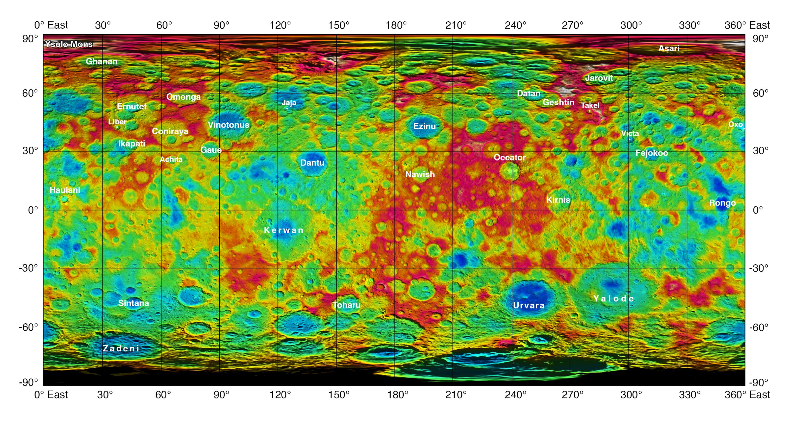
This color-coded map from NASA’s Dawn shows the highs and lows of topography on the surface of dwarf planet Ceres. It is labeled with names of features approved by the International Astronomical Union. The color scale extends about 5 miles (7.5 kilometers) below the reference surface in indigo to 5 miles (7.5 kilometers) above the reference surface in white. Credits: NASA/JPL-Caltech/UCLA/MPS/DLR/IDA
The science team also released a new color-coded topographic map annotated with over a dozen Cerean feature names recently approved by the IAU.
“The names for features on Ceres are all eponymous for agricultural spirits, deities and festivals from cultures around the world. These include Jaja, after the Abkhazian harvest goddess, and Ernutet, after the cobra-headed Egyptian harvest goddess. A 12-mile (20-kilometer) diameter mountain near Ceres’ north pole is now called Ysolo Mons, for an Albanian festival that marks the first day of the eggplant harvest.”
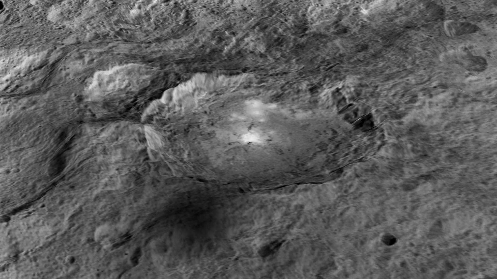
The biggest Cerean mystery of all remains the nature of the bright spots at Occator crater. It’s still under analysis and the team released a new color coded topographic map.
The imagery and other science data may point to evaporation of salty water as the source of the bright spots.
“Occasional water leakage on to the surface could leave salt there as the water would sublime,” Russell told me.
“The big picture that is emerging is that Ceres fills a unique niche,” Prof. Chris Russell, Dawn principal investigator told Universe Today exclusively.
“Ceres fills a unique niche between the cold icy bodies of the outer solar system, with their rock hard icy surfaces, and the water planets Mars and Earth that can support ice and water on their surfaces,” said Russell.
“The irregular shapes of craters on Ceres are especially interesting, resembling craters we see on Saturn’s icy moon Rhea,” says Carol Raymond, Dawn’s deputy principal investigator based at NASA’s Jet Propulsion Laboratory, Pasadena, California. “They are very different from the bowl-shaped craters on Vesta.”
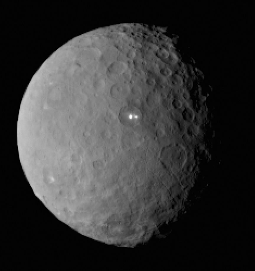
This image was taken by NASA’s Dawn spacecraft of dwarf planet Ceres on Feb. 19 from a distance of nearly 29,000 miles (46,000 km). It shows that the brightest spot on Ceres has a dimmer companion, which apparently lies in the same basin. See below for the wide view. Credit: NASA/JPL-Caltech/UCLA/MPS/DLR/IDA
Dawn was launched on September 27, 2007 by a United Launch Alliance (ULA) Delta II Heavy rocket from Space Launch Complex-17B (SLC-17B) at Cape Canaveral Air Force Station, Florida.
Stay tuned here for Ken’s continuing Earth and planetary science and human spaceflight news.
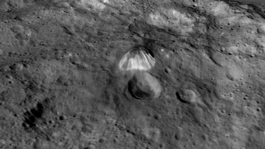
This image, made using images taken by NASA’s Dawn spacecraft during the mission’s High Altitude Mapping Orbit (HAMO) phase, shows Occator crater on Ceres, home to a collection of intriguing bright spots. Credits: NASA/JPL-Caltech/UCLA/MPS/DLR/IDA
The intriguing brightest spots on Ceres lie in a crater named Occator, which is about 60 miles (90 kilometers) across and 2 miles (4 kilometers) deep. Vertical relief has been exaggerated by a factor of five. Exaggerating the relief helps scientists understand and visualize the topography much more easily, and highlights features that are sometimes subtle. Credits: NASA/JPL-Caltech/UCLA/MPS/DLR/IDA/LPI
Video caption: Take a tour of weird Ceres! Visit a 2-mile-deep crater and a 4-mile-tall mountain in the video narrated by mission director Marc Rayman. Get your red/blue glasses ready for the finale – a global view of the dwarf planet in 3D. Credits: NASA/JPL-Caltech/UCLA/MPS/DLR/IDA/LPI/PSI
Mysterious bright spots and a pyramidal shaped mountain star in a daunting new flyover video of dwarf planet Ceres created from imagery gathered by NASA’s history making Dawn mission – the first ever to visit any dwarf planet which simultaneously ranks as the largest world in the main asteroid belt residing between Mars and Jupiter.
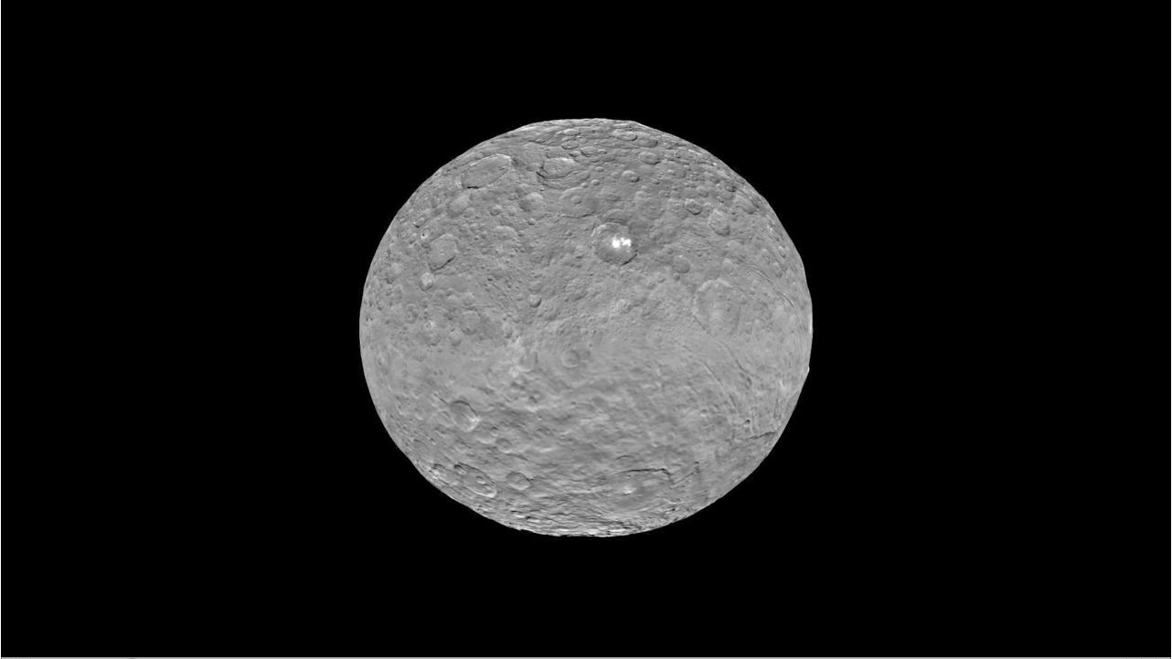
Ceres was nothing more than a fuzzy blob to humankinds most powerful telescopes like the Hubble Space Telescope (HST), until the probe swooped in this year and achieved orbit on March 6, 2015.
The newly released, stunning video takes takes you on a tour like none before for a global cruise over the most fascinating features on Ceres – including the 2-mile-deep (4-km-deep) crater dubbed Occator and a towering 4-mile-tall (6 kilometer-tall) mountain as tall as any in North America.
The spectacular flyover animation was generated from high resolution images taken by Dawn’s framing camera during April and May and is narrated by Marc Rayman, Dawn Chief Engineer and Mission Director of NASA’s Jet Propulsion Laboratory, Pasadena, California.
The video concludes with a 3D view, so you’ll need to whip out your handy red/blue glasses for the finale – a global view of the dwarf planet in 3D.
From the orbital altitude at that time ranging from about 8,400 miles (13,600 kilometers) to 2,700 miles (4,400 kilometers), the highest-resolution regions on Ceres have a resolution of 1,600 feet (480 meters) per pixel.
Pockmarked Ceres is an alien world unlike any other in our solar system, replete with unexplained bright spots and craters of many sizes, large and small.
Occatur has captured popular fascination world-wide because the 60 miles (90 kilometers) diameter crater is rife with a host of the bodies brightest spots and whose nature remains elusive to this day, nearly half a year after Dawn arrived in orbit this past spring.
“Now, after a journey of 3.1 billion miles (4.9 billion kilometers) and 7.5 years, Dawn calls Ceres, home,” says Rayman.
The crater is named after the Roman agriculture deity of harrowing, a method of pulverizing and smoothing soil.
Dawn is an international science mission managed by NASA and equipped with a trio of science instruments from the US, Germany and Italy. The framing camera was provided by the Max Planck Institute for Solar System Research, Göttingen, Germany and the German Aerospace Center (DLR).
The visible and infrared mapping spectrometer (VIR), provided by Italy is an imaging spectrometer that examines Ceres in visible and infrared light.
Dawn’s science team is using the instruments to investigate the light reflecting from Occator at different wavelengths.
From a distance, the crater appeared to be home to a duo of bright spots that looked like a pair of eyes. As Dawn moves ever closer, they became more resolved and now are split into dozens of smaller bright spots.
Global view of Ceres uses data collected by NASA’s Dawn mission in April and May 2015. The highest-resolution parts of the map have a resolution of 1,600 feet (480 meters) per pixel. Credits: NASA/JPL-Caltech/UCLA/MPS/DLR/IDA/LPI/PSI
Although some early speculation centered on the spots possibly being consistent with water ice or salts, newly gathered data “has not found evidence that is consistent with ice. The spots’ albedo -¬ a measure of the amount of light reflected -¬ is also lower than predictions for concentrations of ice at the surface,” according to the scientists.
“The science team is continuing to evaluate the data and discuss theories about these bright spots at Occator,” said Chris Russell, Dawn’s principal investigator at the University of California, Los Angeles, in a statement.
“We are now comparing the spots with the reflective properties of salt, but we are still puzzled by their source. We look forward to new, higher-resolution data from the mission’s next orbital phase.”
Occator lies in Ceres northern hemisphere.
The huge pyramidal mountain lies farther to the southeast of Occator – at 11 degrees south, 316 degrees east.
Based on the latest calculations, the mountain sits about 4 miles (6 kilometers) high, with respect to the surface around it. That make it roughly the same elevation as Mount McKinley in Denali National Park, Alaska, the highest point in North America.
Among the highest features seen on Ceres so far is a mountain about 4 miles (6 kilometers) high, which is roughly the elevation of Mount McKinley in Alaska’s Denali National Park. Vertical relief has been exaggerated by a factor of five to help understand the topography. Credits: NASA/JPL-Caltech/UCLA/MPS/DLR/IDA/LPI
The Texas-sized world is slightly smaller than previously thought. Based on new measurements from Dawn, Ceres’ average diameter to 584 miles (940 kilometers), compared to earlier estimates of 590 miles (950 kilometers).
Dawn made history in March when it simultaneously became the first probe from Earth to reach Ceres as well as the first spacecraft to orbit two extraterrestrial bodies.
It had previously visited Vesta. After achieving orbit in July 2011, Dawn became the first spacecraft from Earth to orbit a body in the main Asteroid Belt.
In sharp contrast to rocky Vesta, Ceres is an icy world.
Scientists believe that Ceres may harbor an ocean of subsurface liquid water as large in volume as the oceans of Earth below a thick icy mantle despite its small size – and thus could be a potential abode for life. Overall Ceres is estimated to be about 25% water by mass.
“We really appreciate the interest in our mission and hope they are as excited as we have been about these scientific surprises,” Russell told Universe Today.
“Since we are only just beginning our investigation, I expect that there will be more surprises. So please stick with us!”
As Dawn spirals down to a lower orbit of about 1,200 miles (1,900 km) above Ceres (and then even lower) using its ion engines, new answers and new mysteries are sure to be forthcoming.
“There are many other features that we are interested in studying further,” said Dawn science team member David O’Brien, with the Planetary Science Institute, Tucson, Arizona.
“These include a pair of large impact basins called Urvara and Yalode in the southern hemisphere, which have numerous cracks extending away from them, and the large impact basin Kerwan, whose center is just south of the equator.”
The mission is expected to last until at least June 2016 depending upon fuel reserves.
Dawn was launched on September 27, 2007 by a United Launch Alliance (ULA) Delta II Heavy rocket from Space Launch Complex-17B (SLC-17B) at Cape Canaveral Air Force Station, Florida.
Stay tuned here for Ken’s continuing Earth and planetary science and human spaceflight news.
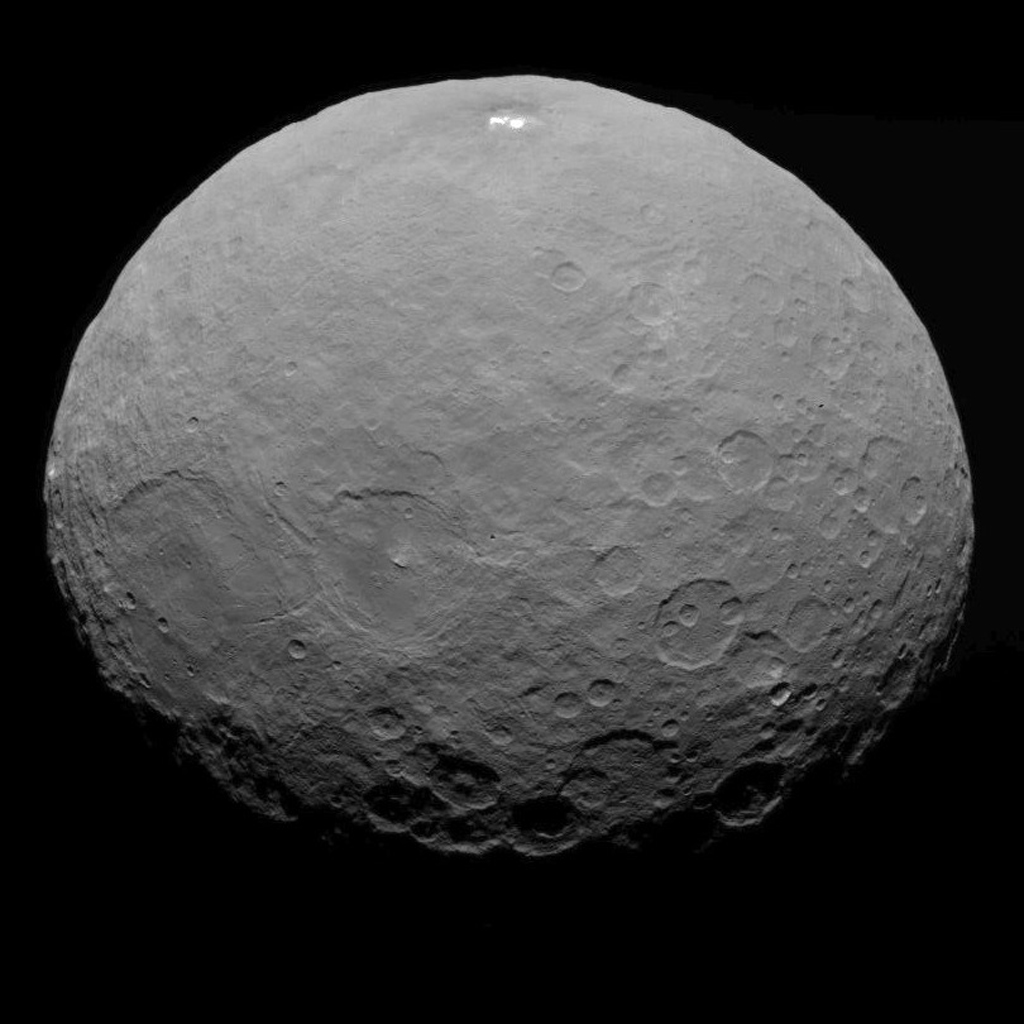
This image of Ceres was taken by NASA's Dawn spacecraft on May 7, 2015, from a distance of 8,400 miles (13,600 kilometers). Credit: NASA/JPL-Caltech/UCLA/MPS/DLR/IDA
Video caption: This new video animation of Ceres was created from images taken by NASA’s Dawn spacecraft at altitudes of 8,400 miles (13,600 kilometers) and 3,200 miles (5,100 kilometers) away. Vertical dimension has been exaggerated by a factor of two and a star field added. Credit: NASA/JPL-Caltech/UCLA/MPS/DLR/IDA
Scientists leading NASA’s Dawn mission to dwarf planet Ceres have just released a brand new animated video showing a dramatic fly over of the heavily cratered world featuring its mysterious bright spots whose exact origin and nature remain elusive.
Meanwhile, the venerable probe has just successfully entered its new and lower mapping orbit on June 3 from which researchers hope to glean hordes of new data to unravel the secrets of the bright spots and unlock the nature of Ceres origin and evolution.
Pockmarked Ceres is an alien world unlike any other in our solar system.
“Dawn completed the maneuvering to reach its second mapping orbit and stopped ion-thrusting on schedule. Since May 9, the spacecraft has reduced its orbital altitude from 8,400 miles (13,600 kilometers) to 2,700 miles (4,400 kilometers),” reported Marc Rayman, Dawn Chief Engineer/ Mission Director of NASA’s Jet Propulsion Laboratory, Pasadena, California.
“As Dawn flew 2,700 miles (4,400 kilometers) over Ceres’ north pole on June 5 that marked the beginning of the new mapping phase, and Dawn began taking photos and making other measurements on schedule.”
Each orbit of Dawn around Ceres at this second science mapping orbit lasts 3.1 days.
The new video was created by the research team based on observations of Ceres that were taken from Dawn’s initial mapping orbit, at an altitude of 8,400 miles (13,600 kilometers), as well as the most recent navigational images taken from 3,200 miles (5,100 kilometers), according to NASA.
It is based on data from over 80 images captured by Dawn’s framing cameras which were provided The German Aerospace Center (DLR) and Max Planck Institute for Solar System Research in Göttingen, Germany.
The images were used to provide a three-dimensional video view. The vertical dimension is exaggerated by a factor of two in the video.
“We used a three-dimensional terrain model that we had produced based on the images acquired so far,” said Dawn team member Ralf Jaumann of the German Aerospace Center (DLR), in Berlin.
“They will become increasingly detailed as the mission progresses — with each additional orbit bringing us closer to the surface.”
Imagery of the mysterious bright spots show them to seemingly be sheets of many spots of water ice, and not just single huge patches. The famous duo of ice spots are located inside the middle of a 57 miles (92 kilometers) wide crater situated in Ceres northern hemisphere.
Dawn is an international science mission managed by NASA’s Jet Propulsion Laboratory, Pasadena, California. The trio of science instruments are from the US, Germany and Italy.
The framing camera was provided by the Max Planck Institute for Solar System Research, Göttingen, Germany and the German Aerospace Center (DLR).
This view of Ceres was taken by Dawn spacecraft on May 23 and shows finer detail becoming visible on the dwarf planet. The spacecraft snapped the image at a distance of 3,200 miles (5,100 kilometers) with a resolution of 1,600 feet (480 meters) per pixel. Credit: NASA/JPL-Caltech/UCLA/MPS/DLR/IDA
Dawn will spend most if June at this second mapping orbit before firing up the ion engines and spiraling yet lower for a mission expected to last until at least June 2016.
Stay tuned here for Ken’s continuing Earth and planetary science and human spaceflight news.
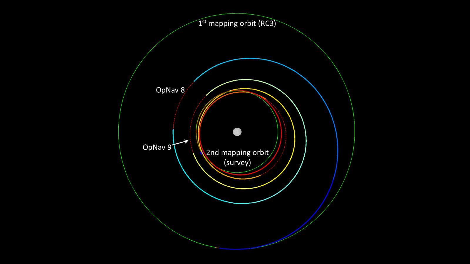
Dawn’s spiral descent from its first mapping orbit (RC3) to its second (survey). The two mapping orbits are shown in green. The color of Dawn’s trajectory progresses through the spectrum from blue, when it began ion-thrusting on May 9, to red, when ion-thrusting concludes on June 3. The red dashed sections show where Dawn is coasting, mostly for telecommunications. The first two coast periods include OpNav 8 and 9. Image credit: NASA/JPL-Caltech
NASA's InSight Mars lander spacecraft in a Lockheed Martin clean room near Denver. As part of a series of deployment tests, the spacecraft was commanded to deploy its solar arrays in the clean room to test and verify the exact process that it will use on the surface of Mars. Credits: NASA/JPL-Caltech/Lockheed Martin
NASA’s ‘Journey to Mars’ is ramping up significantly with ‘InSight’ – as the agency’s next Red Planet lander has now been assembled into its flight configuration and begun a comprehensive series of rigorous and critical environmental stress tests that will pave the path to launch in 2016 on a mission to unlock the riddles of the Martian core.
The countdown clock is ticking relentlessly and in less than nine months time, NASA’s InSight Mars lander is slated to blastoff in March 2016.
InSight, which stands for Interior Exploration Using Seismic Investigations, Geodesy and Heat Transport, is a stationary lander. It will join NASA’s surface science exploration fleet currently comprising of the Curiosity and Opportunity missions which by contrast are mobile rovers.
But before it will even be allowed to get to the launch pad, the Red Planet explorer must first prove its mettle and show that it can operate in and survive the harsh and unforgiving rigors of the space environment via a battery of prelaunch tests. That’s an absolute requirement in order for it to successfully carry out its unprecedented mission to investigate Mars deep interior structure.
InSight’s purpose is to elucidate the nature of the Martian core, measure heat flow and sense for “Marsquakes.” These completely new research findings will radically advance our understanding of the early history of all rocky planets, including Earth and could reveal how they formed and evolved.
“Today, our robotic scientific explorers are paving the way, making great progress on the journey to Mars,” said Jim Green, director of NASA’s Planetary Science Division at the agency’s headquarters in Washington, in a statement.
“Together, humans and robotics will pioneer Mars and the solar system.”
The science deck of NASA’s InSight lander is being turned over in this April 29, 2015, photo from InSight assembly and testing operations inside a clean room at Lockheed Martin Space Systems, Denver. The large circular component on the deck is the protective covering to be placed over InSight’s seismometer after the seismometer is placed directly onto the Martian ground. Credits: NASA/JPL-Caltech/Lockheed Martin
The launch window for InSight opens on March 4 and runs through March 30, 2016.
InSight counts as NASA’s first ever interplanetary mission to launch from California.
The car sized probe will touch down near the Martian equator about six months later in the fall of 2016.
The prime contractor for InSight is Lockheed Martin Space Systems in Denver, Co and the engineering and technical team recently finished assembling the lander into its final configuration.
So now the time has begun to start the shakedown that literally involve “shaking and baking and zapping” the spacecraft to prove its ready and able to meet the March 2016 launch deadline.
During the next seven months of environmental testing at Lockheed’s Denver facility, “the lander will be exposed to extreme temperatures, vacuum conditions of nearly zero air pressure simulating interplanetary space, and a battery of other tests.”
“The assembly of InSight went very well and now it’s time to see how it performs,” said Stu Spath, InSight program manager at Lockheed Martin Space Systems, Denver, in a statement.
“The environmental testing regimen is designed to wring out any issues with the spacecraft so we can resolve them while it’s here on Earth. This phase takes nearly as long as assembly, but we want to make sure we deliver a vehicle to NASA that will perform as expected in extreme environments.”
The first test involves “a thermal vacuum test in the spacecraft’s “cruise” configuration, which will be used during its seven-month journey to Mars. In the cruise configuration, the lander is stowed inside an aeroshell capsule and the spacecraft’s cruise stage – for power, communications, course corrections and other functions on the way to Mars — is fastened to the capsule.”
After the vacuum test, InSight will be subjected to a series of tests simulating the vibrations of launch, separation and deployment shock, as well as checking for electronic interference between different parts of the spacecraft and compatibility testing.
Finally, a second thermal vacuum test will expose the probe “to the temperatures and atmospheric pressures it will experience as it operates on the Martian surface.”
The $425 million InSight mission is expected to operate for about two years on the Martian surface.
Artist rendition of NASA’s Mars InSight (Interior exploration using Seismic Investigations, Geodesy and Heat Transport) Lander. InSight is based on the proven Phoenix Mars spacecraft and lander design with state-of-the-art avionics from the Mars Reconnaissance Orbiter (MRO) and Gravity Recovery and Interior Laboratory (GRAIL) missions. Credit: JPL/NASA
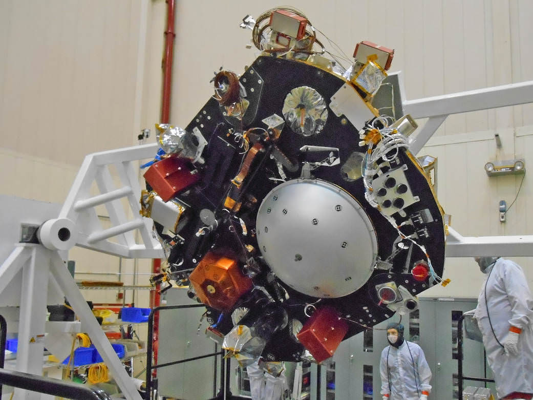
InSight is an international science mission and a near duplicate of NASA’s successful Phoenix Mars landing spacecraft, Bruce Banerdt, InSight Principal Investigator of NASA’s Jet Propulsion Laboratory (JPL), Pasadena, California, told Universe Today.
“InSight is essentially built from scratch, but nearly build-to-print from the Phoenix design,” Banerdt, of NASA’s Jet Propulsion Laboratory (JPL) in Pasadena , Calif, told me. The team can keep costs down by re-using the blueprints pioneered by Phoenix instead of creating an entirely new spacecraft.
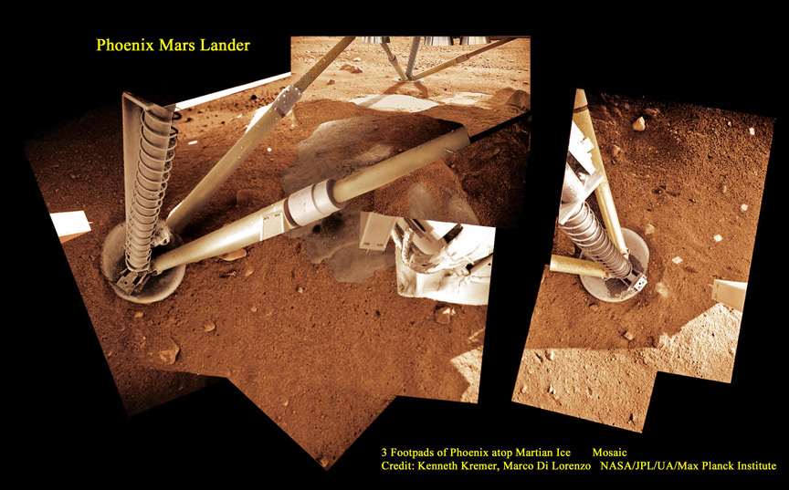
3 Footpads of Phoenix Mars Lander atop Martian Ice. NASA’s Mars InSight spacecraft design is based on the successful 2008 Phoenix lander. This mosaic shows Phoenix touchdown atop Martian ice. Phoenix thrusters blasted away Martian soil and exposed water ice. InSight carries instruments to peer deep into the Red Planet and investigate the nature and size of the mysterious Martian core. Credit: Ken Kremer/kenkremer.com/Marco Di Lorenzo/NASA/JPL/UA/Max Planck Institute
It is funded by NASA’s Discovery Program as well as several European national space agency’s and countries. Germany and France are providing InSight’s two main science instruments; HP3 and SEIS through the Deutsches Zentrum für Luft- und Raumfahrt. or German Aerospace Center (DLR) and the Centre National d’Etudes Spatiales (CNES).
“The seismometer (SEIS, stands for Seismic Experiment for Interior Structure) is from France (built by CNES and IPGP) and the heat flow probe (HP3, stands for Heat Flow and Physical Properties Probe) is from Germany (built by DLR),” Banerdt explained.
SEIS and HP3 are stationed on the lander deck. They will each be picked up and deployed by a robotic arm similar to that flown on Phoenix with some modifications.
Stay tuned here for Ken’s continuing Earth and planetary science and human spaceflight news.
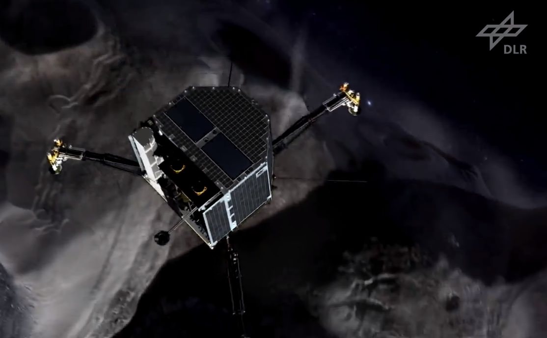
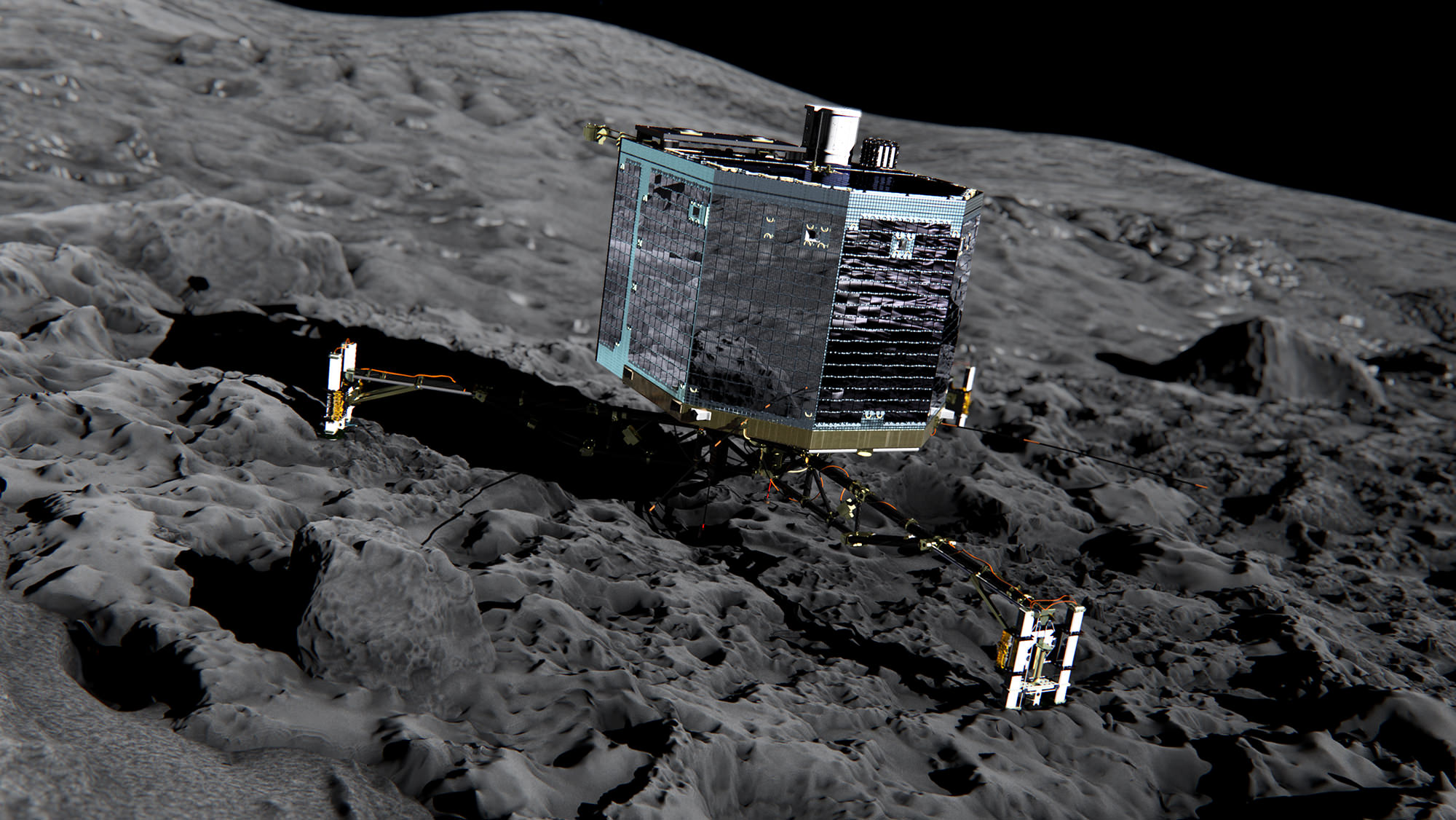
Artist's impression of the 100-kg Philae lander (screenshot) Credit: ESA/DLR
In less than a month, on November 12, 2014, the 100-kg Philae lander will separate from ESA’s Rosetta spacecraft and descend several kilometers down to the dark, dusty and frozen surface of Comet 67P/Churyumov-Gerasimenko, its three spindly legs and rocket-powered harpoon all that will keep it from crashing or bouncing hopelessly back out into space. It will be the culmination of a decade-long voyage across the inner Solar System, a testament to human ingenuity and inventiveness and a shining example of the incredible things we can achieve through collaboration. But first, Philae has to get there… it has to touch down safely and successfully become, as designed, the first human-made object to soft-land on the nucleus of a comet. How will the little spacecraft pull off such a daring maneuver around a tumbling chunk of icy rubble traveling over 18 km/s nearly 509 million km away? The German Aerospace Center (DLR) has released a “trailer” for the event, worthy of the best sci-fi film. Check it out below.
Want to see more? Of course you do. Keep an eye out for the 11-minute short film “Landing on a Comet – The Rosetta Mission” to be released soon on YouTube here, and follow the latest news from the Rosetta mission here (and here on Universe Today, too!)
“The reason we’re at this comet is for science, no other reason. We’re doing this to get the best science. To characterize this comet has never been done before.”
Original Material: DLR (CC-BY 3.0)
Footage: ESA
Credit 67P image: ESA/Rosetta/MPS for OSIRIS Team MPS/UPD/LAM/IAA/SSO/INTA/UPM/DASP/IDA
Music: Omega by TimMcMorris
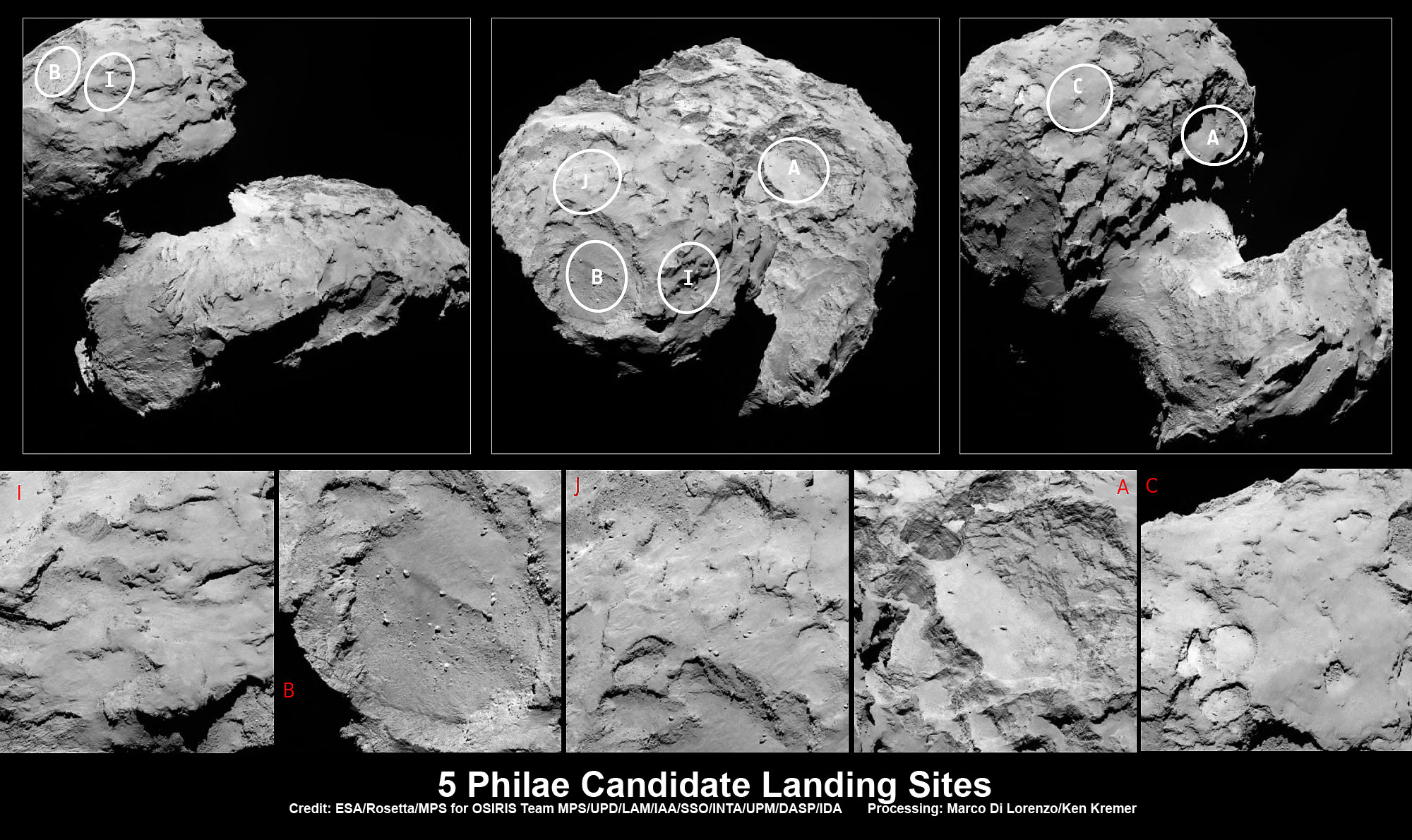
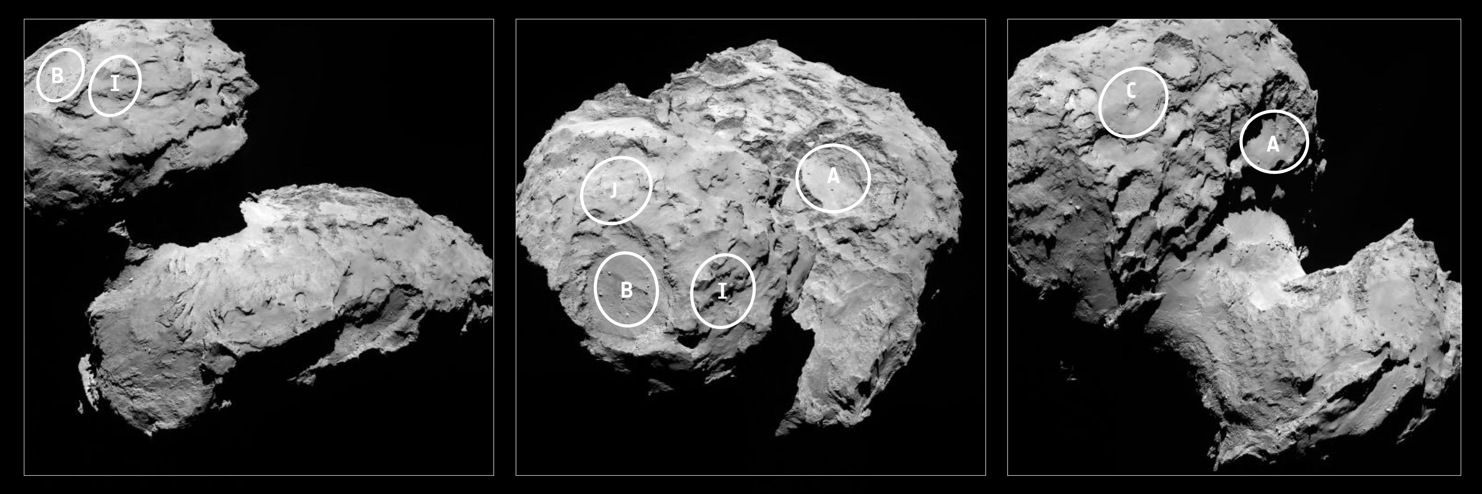
Five candidate sites were identified on Comet 67P/Churyumov-Gerasimenko for Rosetta’s Philae lander. The approximate locations of the five regions are marked on these OSIRIS narrow-angle camera images taken on 16 August 2014 from a distance of about 100 km. Enlarged insets below highlight 5 landing zones. Credits: ESA/Rosetta/MPS for OSIRIS Team MPS/UPD/LAM/IAA/SSO/INTA/UPM/DASP/IDA Processing: Marco Di Lorenzo/Ken Kremer
Five candidate sites were identified on Comet 67P/Churyumov-Gerasimenko for Rosetta’s Philae lander. The approximate locations of the five regions are marked on these OSIRIS narrow-angle camera images taken on 16 August 2014 from a distance of about 100 km. Enlarged insets below highlight 5 landing zones. Credits: ESA/Rosetta/MPS for OSIRIS Team MPS/UPD/LAM/IAA/SSO/INTA/UPM/DASP/IDA Processing: Marco Di Lorenzo/Ken Kremer
Story updated[/caption]
The ‘Top 5’ landing site candidates have been chosen for the Rosetta orbiters piggybacked Philae lander for humankind’s first attempt to land on a comet. See graphics above and below.
The potential touchdown sites were announce today, Aug. 25, based on high resolution measurements collected by ESA’s Rosetta spacecraft over the past two weeks since arriving at the bizarre and pockmarked Comet 67P/Churyumov-Gerasimenko on Aug. 6, 2014.
Rosetta is a mission of many firsts, including history’s first ever attempt to orbit a comet for long term study.
Philae’s history making landing on comet 67P is currently scheduled for around Nov. 11, 2014, and will be entirely automatic. The 100 kg lander is equipped with 10 science instruments.
“This is the first time landing sites on a comet have been considered,” said Stephan Ulamec, Lander Manager at DLR (German Aerospace Center), in an ESA statement.
Artist impression of Philae on the surface of comet 67P/Churyumov-Gerasimenko. Credit: ESA/ATG medialab
Since rendezvousing with the comet after a decade long chase of over 6.4 billion kilometers (4 Billion miles), a top priority task for the science and engineering team leading Rosetta has been “Finding a landing strip” for the Philae comet lander.
“The challenge ahead is to map the surface and find a landing strip,” said Andrea Accomazzo, ESA Rosetta Spacecraft Operations Manager, at the Aug. 6 ESA arrival live webcast.
So ‘the clock is ticking’ to select a suitable landing zone soon as the comet warms up and the surface becomes ever more active as it swings in closer to the sun and makes the landing ever more hazardous.
This past weekend, the site selection team met at CNES, Toulouse, France, and intensively discussed and scrutinized a preliminary list of 10 potential sites, and whittled that down to the ‘Top 5.’
Their goal was to find a ‘technically feasible’ touchdown site that was both safe and scientifically interesting.
“The site must balance the technical needs of the orbiter and lander during all phases of the separation, descent, and landing, and during operations on the surface with the scientific requirements of the 10 instruments on board Philae,” said ESA.
They also had to be within an ellipse of at least 1 square kilometer (six-tenths of a square mile) in diameter due to uncertainties in navigation as well as many other factors.
“For each possible zone, important questions must be asked: Will the lander be able to maintain regular communications with Rosetta? How common are surface hazards such as large boulders, deep crevasses or steep slopes? Is there sufficient illumination for scientific operations and enough sunlight to recharge the lander’s batteries beyond its initial 64-hour lifetime, while not so much as to cause overheating?” according to ESA.
Stephan Ulamec, Philae Lander Manager at DLR (German Aerospace Center) discusses landing during ESA webcast of Rosetta’s arrival at comet Comet 67P/Churyumov-Gerasimenko. Credit: ESA
The Landing Site Selection Group (LSSG) team was comprised of engineers and scientists from Philae’s Science, Operations and Navigation Centre (SONC) at CNES, the Lander Control Centre (LCC) at DLR, scientists representing the Philae Lander instruments as well as the ESA Rosetta team, which includes representatives from science, operations and flight dynamics.
“Based on the particular shape and the global topography of Comet 67P/ Churyumov-Gerasimenko, it is probably no surprise that many locations had to be ruled out,” said Ulamec.
“The candidate sites that we want to follow up for further analysis are thought to be technically feasible on the basis of a preliminary analysis of flight dynamics and other key issues – for example they all provide at least six hours of daylight per comet rotation and offer some flat terrain. Of course, every site has the potential for unique scientific discoveries.”
When Rosetta arrived on Aug. 6, it was initially orbiting at a distance of about 100 km (62 miles) in front of the comet. Carefully timed thruster firings then brought it to within about 80 km distance. And it is moving far closer – to within 50 kilometers (31 miles) and even closer!
Upon arrival the comet was 522 million km from the Sun. As Rosetta escorts the comet looping around the sun, they move much closer. By landing time in mid-November they are only about 450 million km (280 million mi) from the sun.
At closest approach on 13 August 2015 the comet and Rosetta will be 185 million km from the Sun. That corresponds to an eightfold increase in the light received from the Sun.
Five candidate sites were identified on Comet 67P/Churyumov-Gerasimenko for Rosetta’s Philae lander. The approximate locations of the five regions are marked on these OSIRIS narrow-angle camera images taken on 16 August 2014 from a distance of about 100 km. Credits: ESA/Rosetta/MPS for OSIRIS Team MPS/UPD/LAM/IAA/SSO/INTA/UPM/DASP/IDA
Therefore Rosetta and Philae will simultaneously study the warming effects of the sun as the comet outgases dust, water and much more.
The short period Comet 67P/Churyumov-Gerasimenko has an orbital period of 6.5 years.
“The comet is very different to anything we’ve seen before, and exhibits spectacular features still to be understood,” says Jean-Pierre Bibring, a lead lander scientist and principal investigator of the CIVA instrument.
“The five chosen sites offer us the best chance to land and study the composition, internal structure and activity of the comet with the ten lander experiments.”
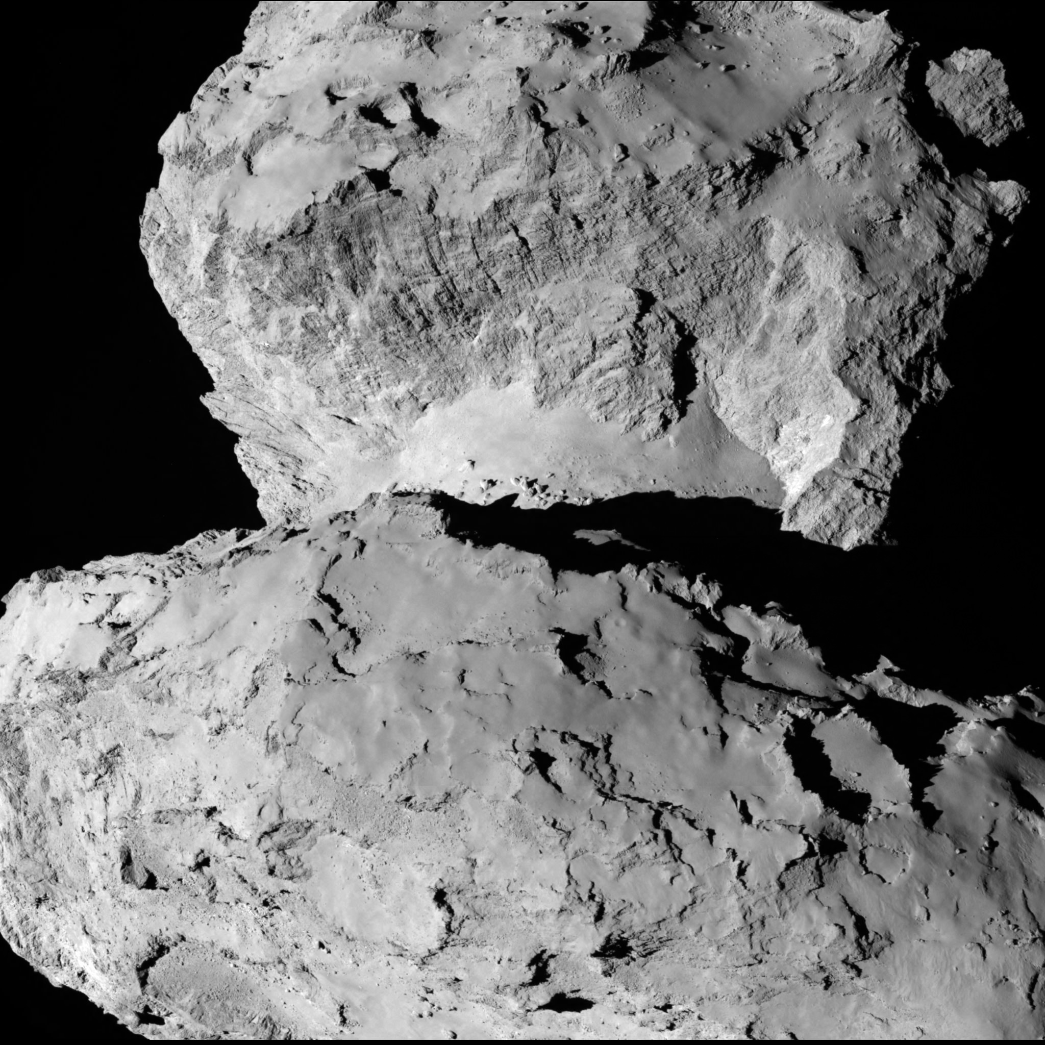
A close-up view of Comet 67P/Churyumov–Gerasimenko taken by the Rosetta spacecraft on Aug. 7, 2014. Credit: ESA/Rosetta/MPS for OSIRIS Team MPS/UPD/LAM/IAA/SSO/INTA/UPM/DASP/IDA
The ‘Top 5’ zones will be ranked by 14 September. Three are on the ‘head’ and two are on the ‘body’ of the bizarre two lobed alien world.
And a backup landing site will also be chosen for planning purposes and to develop landing sequences.
The ultimate selection of the primary landing site is slated for 14 October after consultation between ESA and the lander team on a “Go/No Go” decision.
The three-legged lander will fire two harpoons and use ice screws to anchor itself to the 4 kilometer (2.5 mile) wide comet’s surface. Philae will collect stereo and panoramic images and also drill 23 centimeters into and sample its incredibly varied surface.
Why study comets?
Comets are leftover remnants from the formation of the solar system. Scientists believe they delivered a vast quantity of water to Earth. They may have also seeded Earth with organic molecules – the building blocks of life as we know it.
Any finding of organic molecules will be a major discovery for Rosetta and ESA and inform us about the origin of life on Earth.
Read an Italian language version of this story by my imaging partner Marco Di Lorenzo – here
Stay tuned here for Ken’s continuing Earth and Planetary science and human spaceflight news.
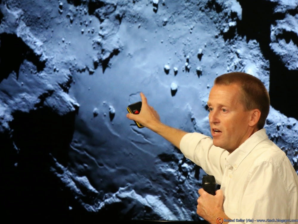
Holger Sierks, OSIRIS principal investigator, discusses spectacular hi res comet images returned so far by Rosetta during the Aug. 6 ESA webcast from mission control at ESOC, Darmstadt, Germany. Credit: Roland KellerESA’s Rosetta Spacecraft nears final approach to Comet 67P/Churyumov-Gerasimenko in late July 2014. This collage of imagery from Rosetta combines Navcam camera images at right taken nearing final approach from July 25 (3000 km distant) to July 31, 2014 (1327 km distant), with OSIRIS wide angle camera image at left of comet’s expanding coma cloud on July 25. Images to scale and contrast enhanced to show further detail. Credit: ESA/Rosetta/NAVCAM/OSIRIS/MPS/UPD/LAM/IAA/SSO/INTA/UPM/DASP/IDA Collage/Processing: Marco Di Lorenzo/Ken Kremer
Holger Sierks, OSIRIS principal investigator, discusses spectacular hi res comet images returned so far by Rosetta during the Aug. 6 ESA webcast from mission control at ESOC, Darmstadt, Germany. Credit: Roland Keller
Animation Caption: Possible landing sites on Comet 67P/Churyumov-Gerasimenko. The model shows the illumination of the comets surface and regions under landing site consideration for the Philae lander on board ESA’s Rosetta spececraft . Credit: CNES
“The race is on” to find a safe and scientifically interesting landing site for the Philae lander piggybacked on ESA’s Rosetta spacecraft as it swoops in ever closer to the heavily cratered Comet 67P/Churyumov-Gerasimenko since arriving two weeks ago after a decade long chase of 6.4 billion kilometers (4 Billion miles).
Rosetta made history by becoming the first ever probe from Earth to orbit a comet upon arrival on Aug. 6, 2014.
The probe discovered an utterly alien and bizarre icy wanderer that science team member Mark McCaughrean, of ESA’s Science Directorate, delightedly calls a ‘Scientific Disneyland.’
“It’s just astonishing,” he said during a live ESA webcast of the Aug. 6 arrival event.
Now, another audacious and history making event is on tap – Landing on the comet!
To enable a safe landing, Rosetta is moving in closer to the comet to gather higher resolution imaging and spectroscopic data. When Rosetta arrived on Aug. 6, it was initially orbiting at a distance of about 100 km (62 miles). As of today, carefully timed thruster firings have brought it to within about 80 km distance. And it will get far closer.
Right now a top priority task for the science and engineering team leading Rosetta is “Finding a landing strip” for the Philae comet lander.
Philae’s landing on comet 67P is currently scheduled for Nov. 11, 2014. The 100 kg lander is equipped with 10 science instruments
“The challenge ahead is to map the surface and find a landing strip,” said Andrea Accomazzo, ESA Rosetta Spacecraft Operations Manager, at the Aug. 6 ESA webcast.
The team responsibility for choosing the candidate sites comprises “the Landing Site Selection Group (LSSG), which comprises engineers and scientists from Philae’s Science, Operations and Navigation Centre (SONC) at CNES, the Lander Control Centre (LCC) at DLR, scientists representing the Philae Lander instruments, and supported by the ESA Rosetta team, which includes representatives from science, operations and flight dynamics,” according to an ESA statement.
This week the team is intensively combing through a preliminary list of 10 potential landing sites.
Over the weekend they will whittle the list down to five candidate landing sites for continued detailed analysis.
ESA will announce the Top 5 landing site candidates on Monday, Aug. 25.
Where will Philae land?
This image of comet 67P/Churyumov-Gerasimenko shows the diversity of surface structures on the comet’s nucleus. It was taken by the Rosetta spacecraft’s OSIRIS narrow-angle camera on August 7, 2014. At the time, the spacecraft was 65 miles (104 kilometers) away from the 2.5 mile (4 kilometer) wide nucleus. Credit: ESA/Rosetta/MPS for OSIRIS Team MPS/UPD/LAM/IAA/SSO/INTA/UPM/DASP/IDA/Enhanced processing Marco Di Lorenzo/Ken Kremer
The decision rests on the results of Rosetta’s ongoing global mapping campaign, including high resolution imaging from the OSIRIS and NAVCAM cameras and further observations from the other science instruments, especially MIRO, VIRTIS, ALICE, GIADA and ROSINA.
The surface criteria for a suitable landing site include day time landing illumination, a balance between day and night to allow the solar panels to recharge the batteries, avoiding steep slopes, large boulders and deep crevasses so it doesn’t topple over.
Of course the team also must consider the comet’s rotation period (12.4 hours) and axis of rotation (see animation at top). Sites near the equator offering roughly equal periods of day and night may be preferred.
The selection of the primary landing site is slated for mid-October after consultation between ESA and the lander team on a “Go/No Go” decision.
The three-legged lander will fire two harpoons and use ice screws to anchor itself to the 4 kilometer (2.5 mile) wide comet’s surface. Philae will collect stereo and panoramic images and also drill 23 centimeters into and sample its incredibly varied surface.
Artist impression of Philae on the surface of comet 67P/Churyumov-Gerasimenko. Credit: ESA/ATG medialab
Read an Italian language version of this story by my imaging partner Marco Di Lorenzo – here
Stay tuned here for Ken’s continuing Earth and Planetary science and human spaceflight news.