Spectacular Panoramas from Curiosity Reveal Layered Martian Rock Formations Like America’s Desert Southwest

Dramatic hillside view showing sloping buttes and layered outcrops within of the Murray Buttes region on lower Mount Sharp from the Mast Camera (Mastcam) on NASA's Curiosity Mars rover. This photo mosaic is stitched and cropped from Mastcam camera raw images taken on Sol 1454, Sept. 8, 2016, with added artificial sky. Credit: NASA/JPL/MSSS/Ken Kremer/kenkremer.com/Marco Di Lorenzo
Spectacular wide angle mosaic view showing sloping buttes and layered outcrops within the Murray Buttes region on lower Mount Sharp from the Mast Camera (Mastcam) on NASA's Curiosity Mars rover. This photo mosaic is stitched from Mastcam camera raw images taken on Sol 1454, Sept. 9, 2016 with added artificial sky.  Credit: NASA/JPL/MSSS/Ken Kremer/kenkremer.com/Marco Di Lorenzo
Spectacular wide angle mosaic view showing sloping buttes and layered outcrops within the Murray Buttes region on lower Mount Sharp from the Mast Camera (Mastcam) on NASA’s Curiosity Mars rover. This photo mosaic is stitched from Mastcam camera raw images taken on Sol 1454, Sept. 8, 2016 with added artificial sky. Credit: NASA/JPL/MSSS/Ken Kremer/kenkremer.com/Marco Di Lorenzo

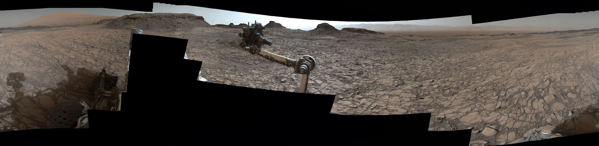
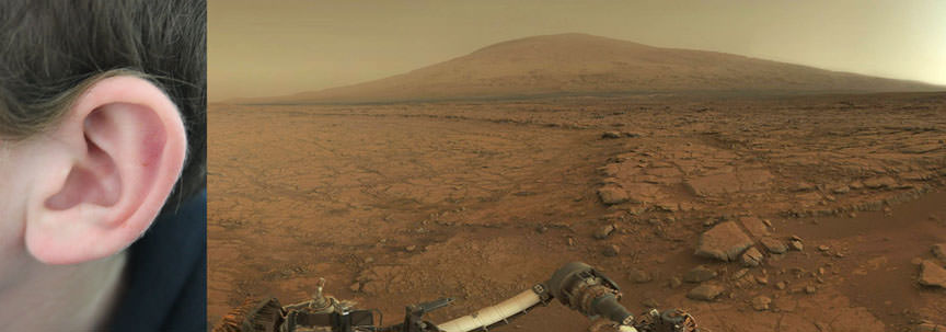
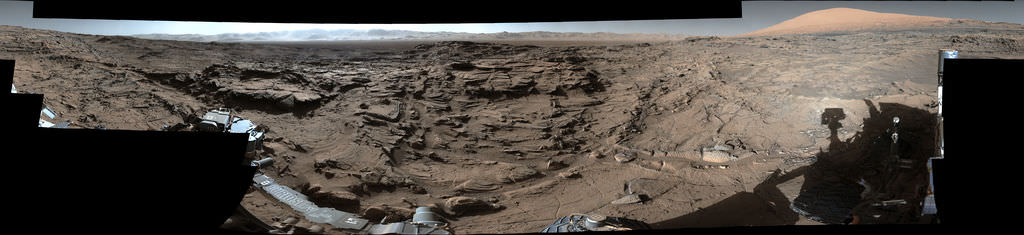
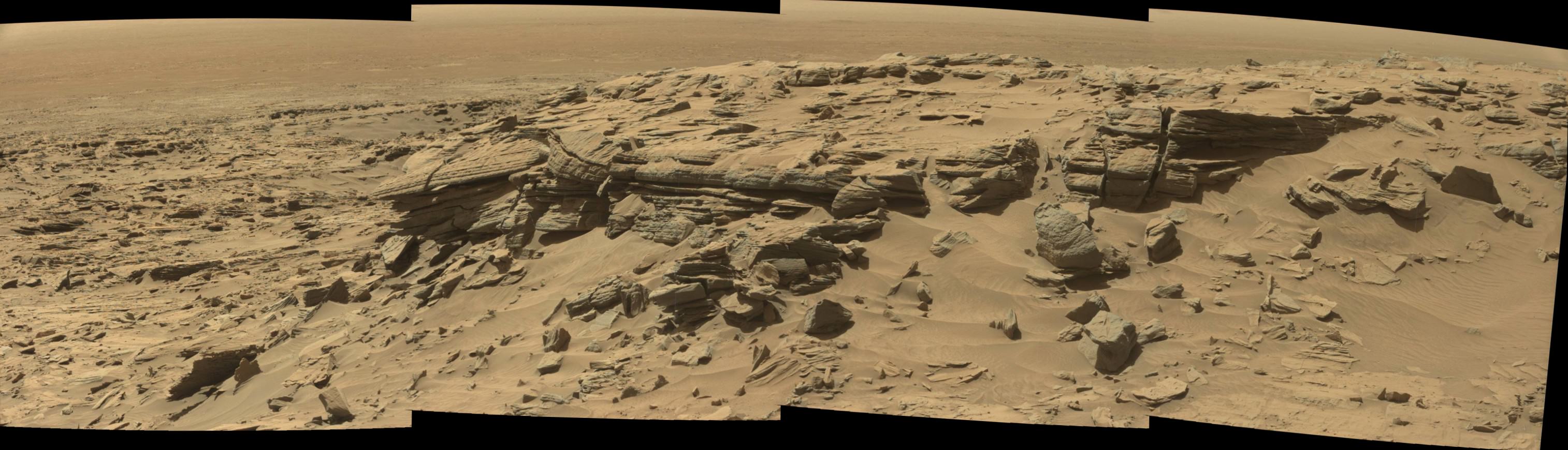
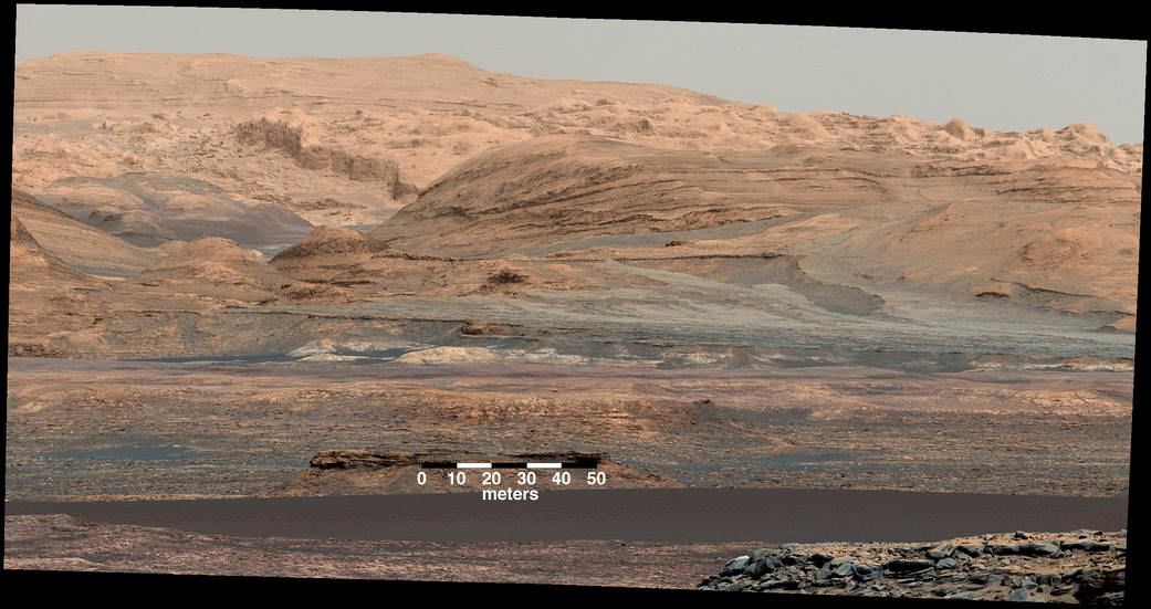
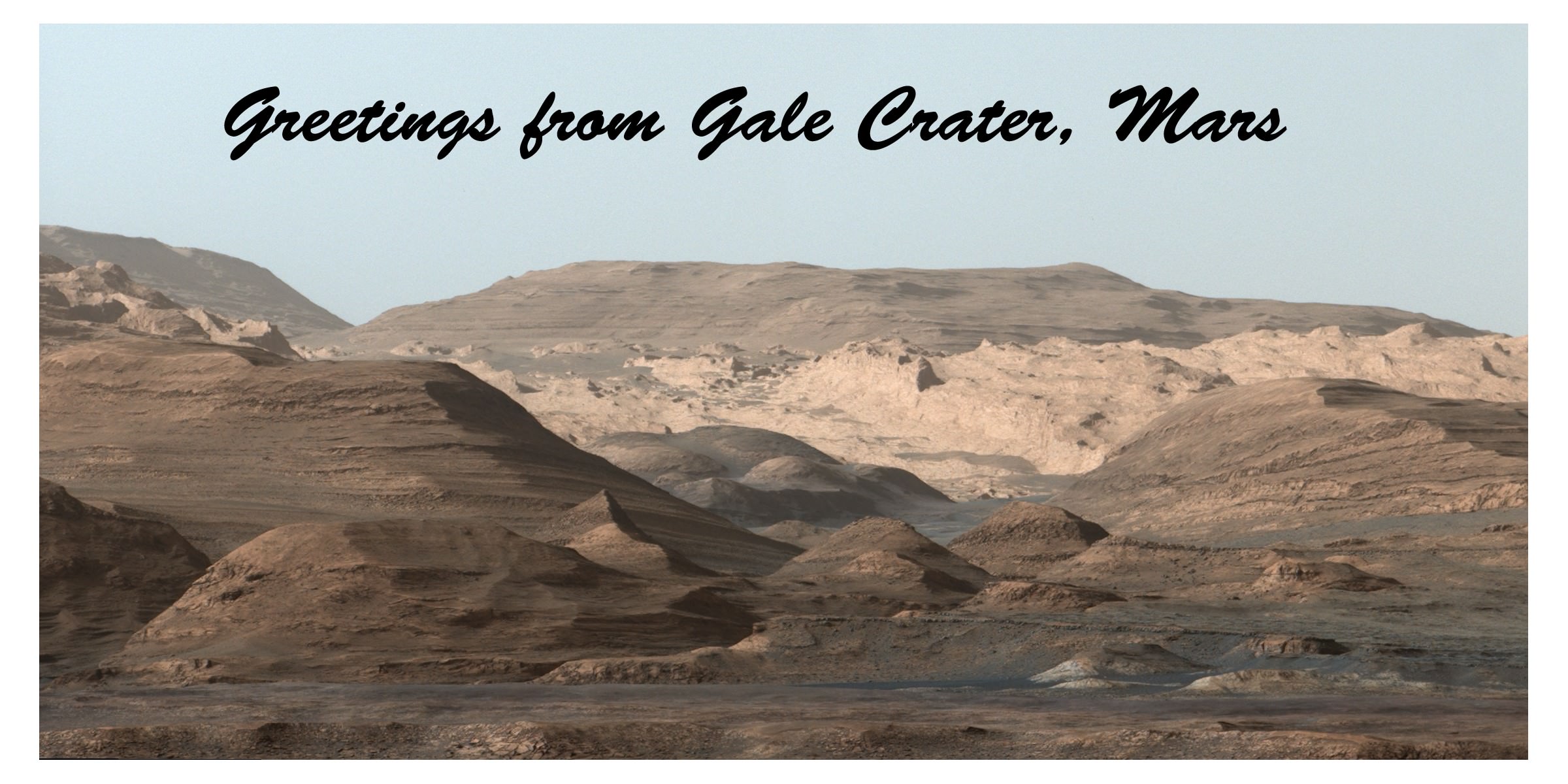
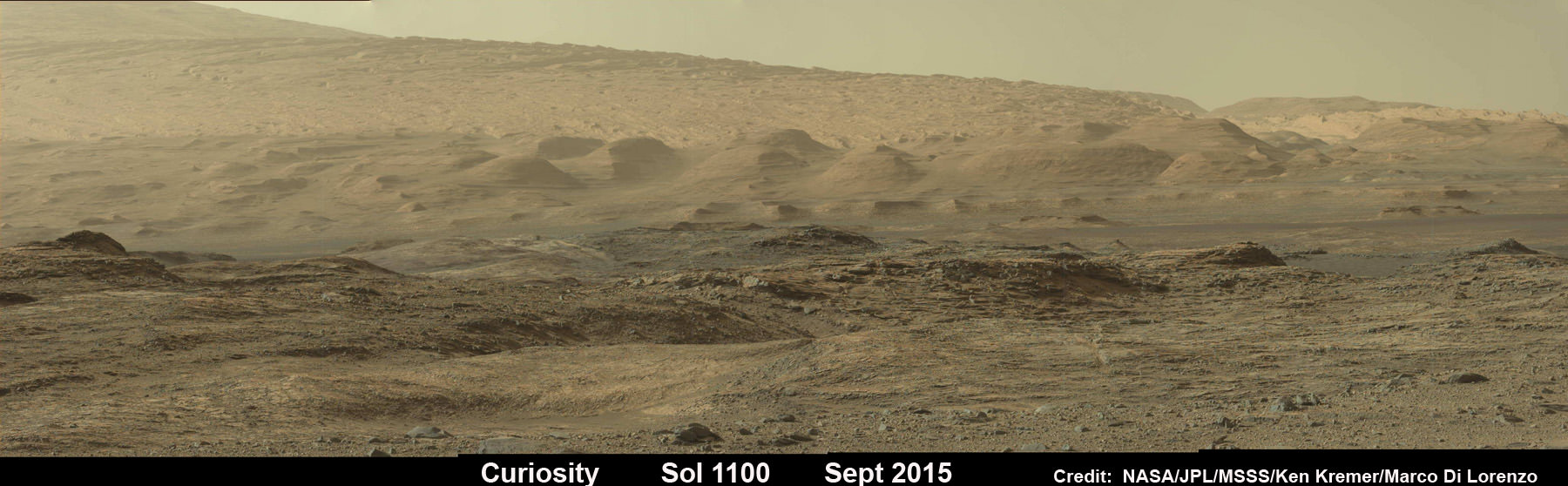
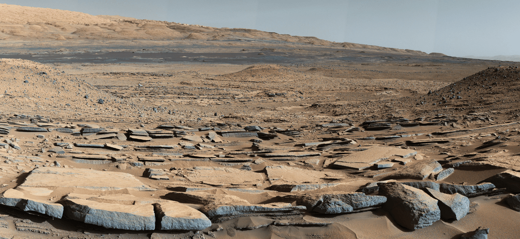
The most stunning panoramic vistas likely ever snapped by NASA’s Curiosity rover reveal spectacularly layered Martian rock formations in such exquisite detail that they look and feel just like America’s desert Southwest landscapes. They were just captured a week ago and look like a scene straight out of the hugely popular science fiction movie ‘The Martian’ – only they are real !!

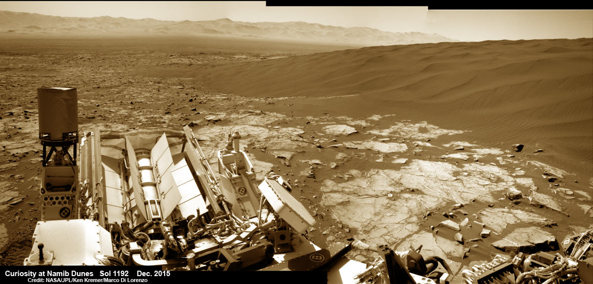
Indeed several magnificent panoramas were taken by Curiosity in just the past week and you can see our newly stitched mosaic versions of several – above and below.

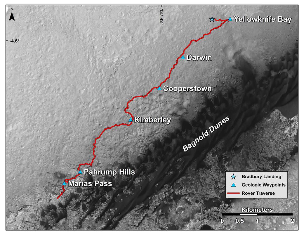
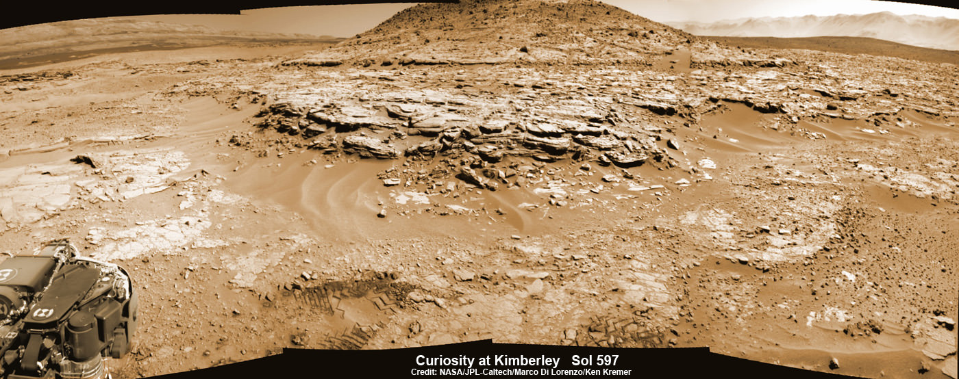
The rock formations lie in the “Murray Buttes” region of lower Mount Sharp where Curiosity has been exploring for roughly the past month. She just finished a campaign of detailed science observations and is set to bore a new sampling hole into the Red Planet, as you read this.

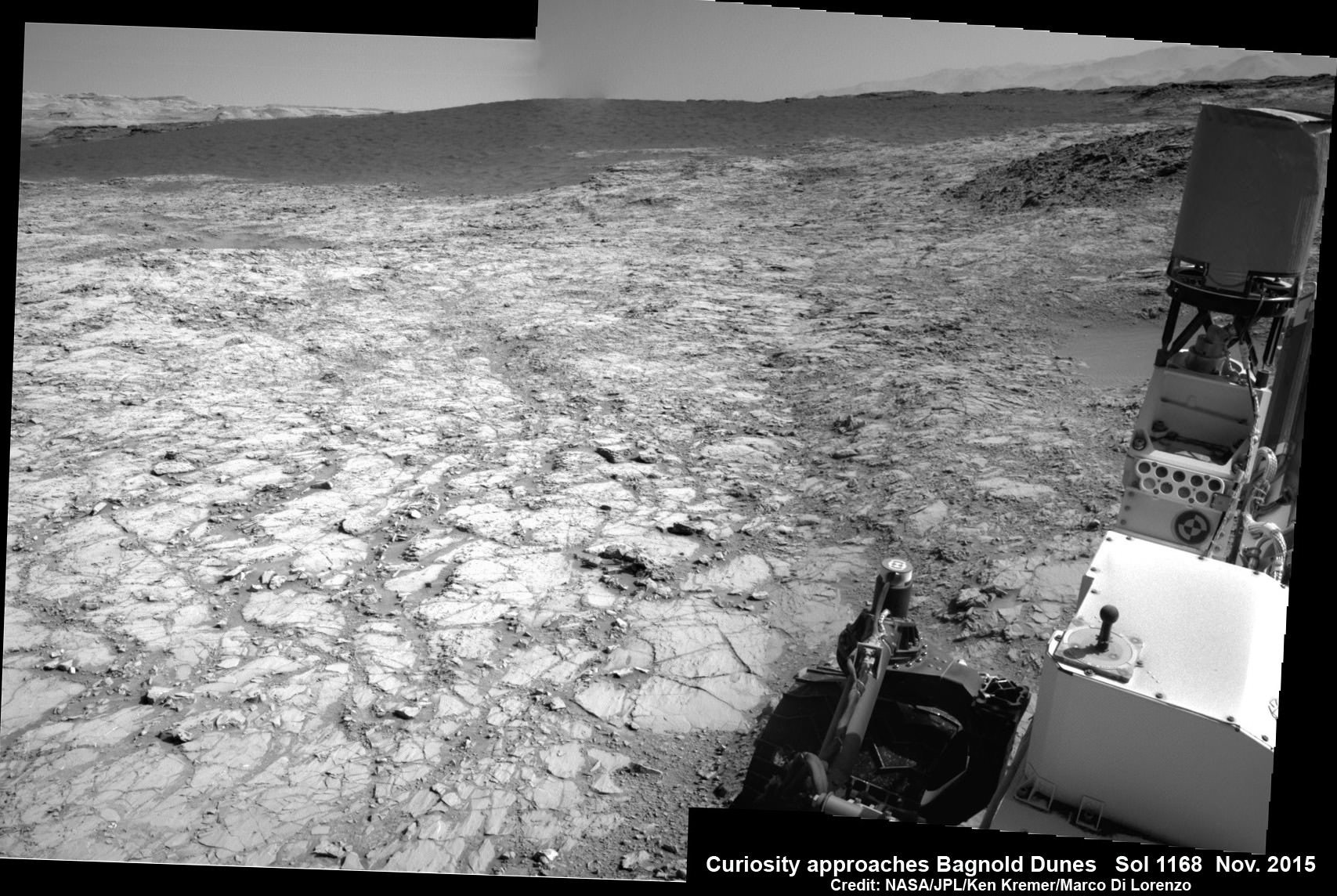
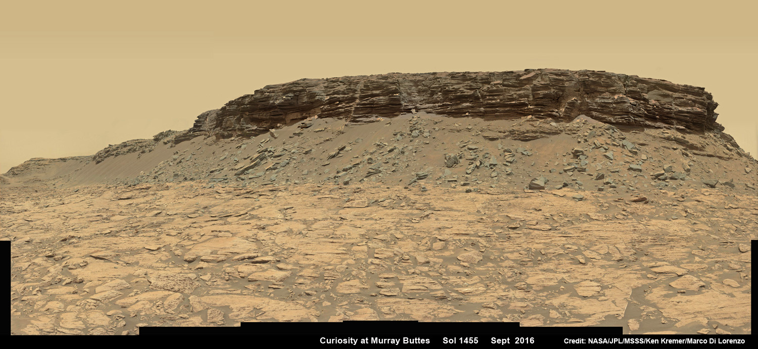
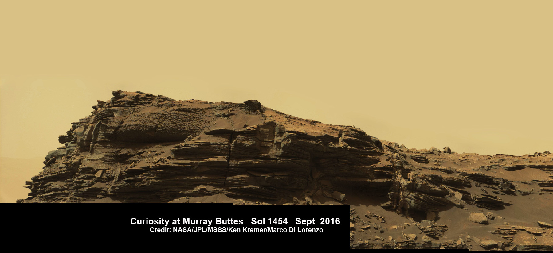
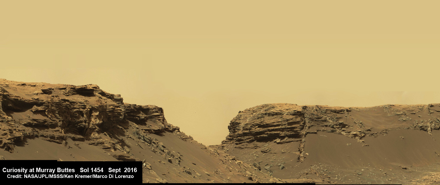
While scouting around the “Murray Buttes,” the SUV sized rover captured thousands of color and black and white raw images to document the geology of this thus far most unrivaled spot on the Red Planet ever visited by an emissary from Earth.

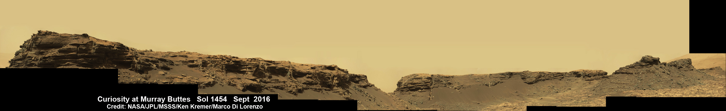
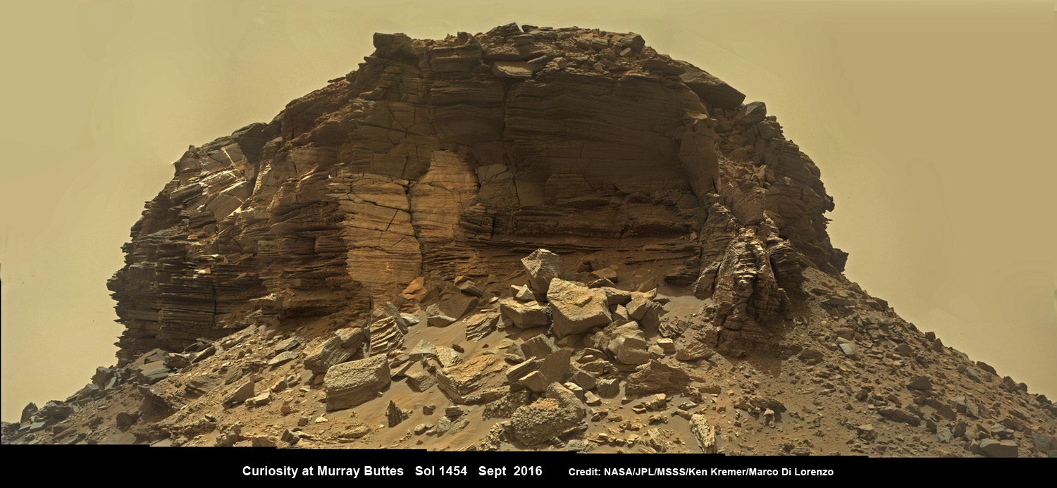
So the image processing team of Ken Kremer and Marco Di Lorenzo has begun stitching together wide angle mosaic views starting with images gathered by the high resolution mast mounted Mastcam right color camera, or M-100, on Sept, 8, 2016, or Sol 1454 of the robots operations on Mars.

Dramatic closeup mosaic view of hilly outcrop with sandstone layers showing cross-bedding  in the Murray Buttes region on lower Mount Sharp from the Mast Camera (Mastcam) on NASA's Curiosity Mars rover. This photo mosaic is stitched from Mastcam camera raw images taken on Sol 1454, Sept. 8, 2016, with added artificial sky.  Credit: NASA/JPL/MSSS/Ken Kremer/kenkremer.com/Marco Di Lorenzo
Dramatic closeup mosaic view of Martian butte with sandstone layers showing cross-bedding in the Murray Buttes region on lower Mount Sharp from the Mast Camera (Mastcam) on NASA’s Curiosity Mars rover. This photo mosaic is stitched from Mastcam camera raw images taken on Sol 1454, Sept. 8, 2016, with added artificial sky. Credit: NASA/JPL/MSSS/Ken Kremer/kenkremer.com/Marco Di Lorenzo

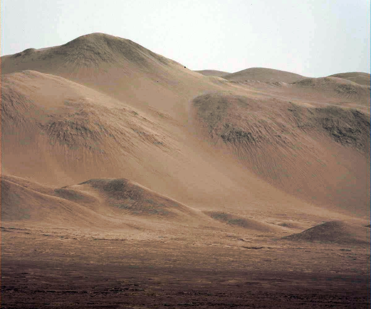
The mosaics give context and show us exactly what the incredible alien surroundings look like where the six wheeled rover is exploring today.

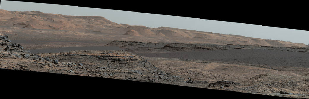
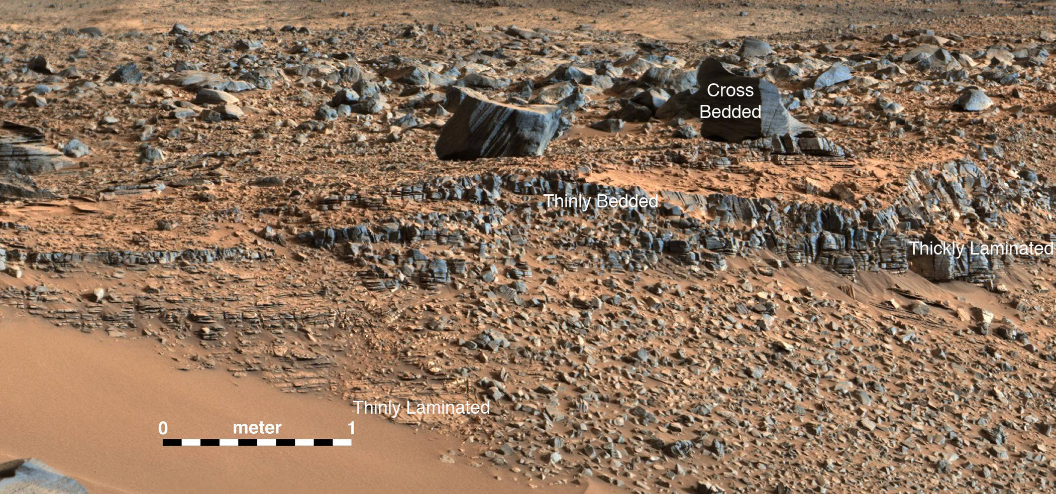
The imagery of the Murray Buttes and mesas show them to be eroded remnants of ancient sandstone that originated when winds deposited sand after lower Mount Sharp had formed.

Wide angle mosaic shows lower region of Mount Sharp at center in between spectacular sloping hillsides  and layered rock outcrops of the Murray Buttes region in Gale Crater as imaged by the Mast Camera (Mastcam) on NASA's Curiosity Mars rover. This photo mosaic is stitched from Mastcam camera raw images taken on Sol 1451, Sept. 5, 2016 with added artificial sky.  Credit: NASA/JPL/MSSS/Ken Kremer/kenkremer.com/Marco Di Lorenzo
Wide angle mosaic shows lower region of Mount Sharp at center in between spectacular sloping hillsides and layered rock outcrops of the Murray Buttes region in Gale Crater as imaged by the Mast Camera (Mastcam) on NASA’s Curiosity Mars rover. This photo mosaic is stitched from Mastcam camera raw images taken on Sol 1451, Sept. 5, 2016 with added artificial sky. Credit: NASA/JPL/MSSS/Ken Kremer/kenkremer.com/Marco Di Lorenzo

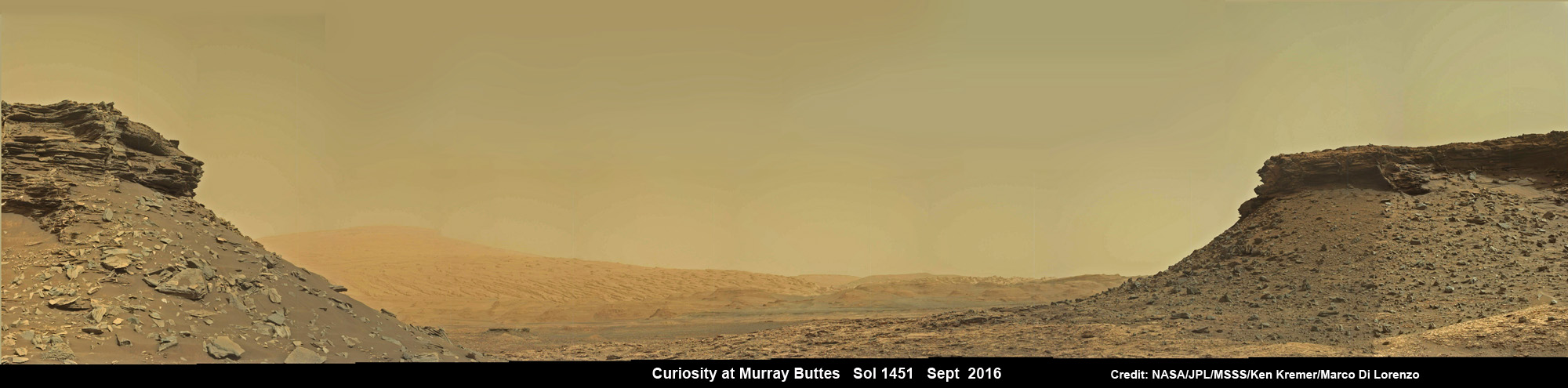
Scanning around the Murray Buttes mosaics one sees finely layered rocks, sloping hillsides, the distant rim of Gale Crater barely visible through the dusty haze, dramatic hillside outcrops with sandstone layers exhibiting cross-bedding. The presence of “cross-bedding” indicates that the sandstone was deposited by wind as migrating sand dunes, says the team.

Wide angle mosaic view shows spectacular buttes and layered sandstone in the Murray Buttes region on lower Mount Sharp from the Mastcam cameras on NASA's Curiosity Mars rover. This photo mosaic is stitched from Mastcam camera raw images taken on Sol 1455, Sept. 9, 2016 with added artificial sky.  Credit: NASA/JPL/MSSS/Ken Kremer/kenkremer.com/Marco Di Lorenzo
Wide angle mosaic view shows spectacular buttes and layered sandstone in the Murray Buttes region on lower Mount Sharp from the Mastcam cameras on NASA’s Curiosity Mars rover. This photo mosaic was assembled from Mastcam color camera raw images taken on Sol 1455, Sept. 9, 2016 and stitched by Marco Di Lorenzo and Ken Kremer, with added artificial sky. Credit: NASA/JPL/MSSS/Ken Kremer/kenkremer.com/Marco Di Lorenzo

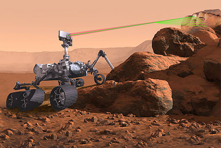
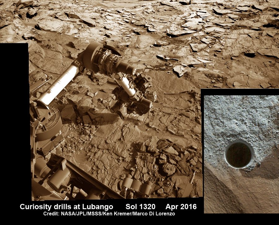
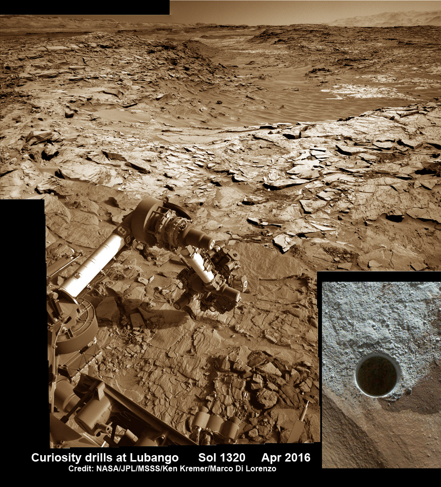
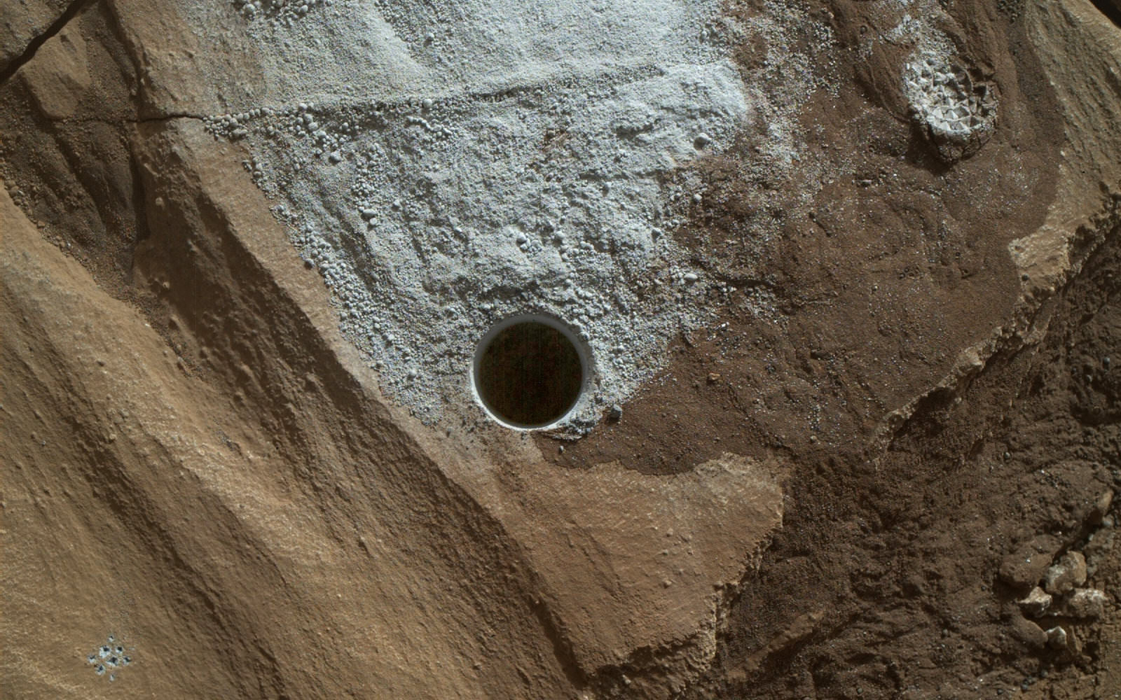
But there is no time to rest as she was commanded to head further south to the last of these Murray Buttes. And right now the team is implementing a plan for Curiosity to drill a new hole in Mars today – at a target named “Quela” at the base of the last of the buttes. The rover approached the butte from the south side a few days ago to get in place and plan for the drilling, take imagery to document stratigraphy and make compositional observations with the ChemCam laser instrument.

“It’s always an exciting day on Mars when you prepare to drill another sample – an engineering feat that we’ve become so accustomed to that I sometimes forget how impressive this really is!” wrote Lauren Edgar, in a mission update today. Edgar is a Research Geologist at the USGS Astrogeology Science Center and a member of the MSL science team.

Curiosity will then continue further south to begin exploring higher and higher sedimentary layers up Mount Sharp. The “Murray Buttes” are the entry way along Curiosity’s planned route up lower Mount Sharp.

Dramatic closeup view of hillside outcrop with sandstone layers showing cross-bedding  in the Murray Buttes region on lower Mount Sharp from the Mast Camera (Mastcam) on NASA's Curiosity Mars rover. This photo mosaic is stitched and cropped from Mastcam camera raw images taken on Sol 1454, Sept. 8, 2016, with added artificial sky.  Credit: NASA/JPL/MSSS/Ken Kremer/kenkremer.com/Marco Di Lorenzo
Dramatic closeup view of hillside outcrop with sandstone layers showing cross-bedding in the Murray Buttes region on lower Mount Sharp from the Mast Camera (Mastcam) on NASA’s Curiosity Mars rover. This photo mosaic is stitched and cropped from Mastcam camera raw images taken on Sol 1454, Sept. 8, 2016, with added artificial sky. Credit: NASA/JPL/MSSS/Ken Kremer/kenkremer.com/Marco Di Lorenzo

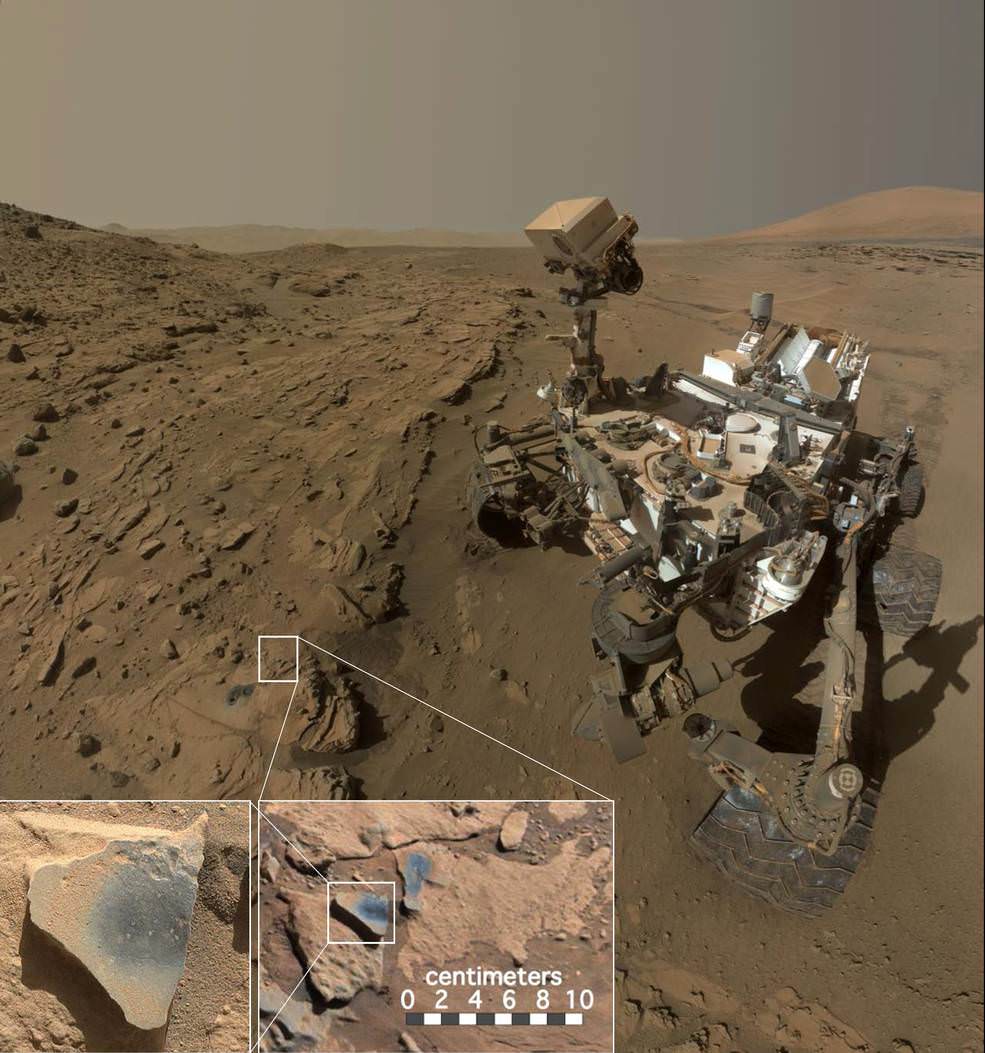
Meanwhile Curiosity is still conducting science observations of the last drill sample gathered from the “Marimba” target in August focusing on MAHLI and APXS examination of the dump pile leftovers from the sieved sample. She just completed chemical analysis of the sieved sample using the miniaturized SAM and CheMin internal chemistry laboratories.

It’s interesting to note that although the buttes are striking, their height also presents communications issues by blocking radio signals with NASA’s orbiting relay satellites. NASA’s Opportunity rover faced the same issues earlier this year while exploring inside the high walled Marathon Valley along Ecdeavour Crater.

“While the buttes are beautiful, they pose a challenge to communications, because they are partially occluding communications between the rover and the satellites we use to relay data (MRO and ODY), so sometimes the data volume that we can relay is pretty low” wrote Edgar.

“But it’s a small price to pay for the great stratigraphic exposures and gorgeous view!”

Dramatic hillside view showing sloping buttes and layered outcrops within of the Murray Buttes region on lower Mount Sharp from the Mast Camera (Mastcam) on NASA's Curiosity Mars rover. This photo mosaic is stitched and cropped from Mastcam camera raw images taken on Sol 1454, Sept. 8, 2016, with added artificial sky.  Credit: NASA/JPL/MSSS/Ken Kremer/kenkremer.com/Marco Di Lorenzo
Dramatic hillside view showing sloping buttes and layered outcrops within of the Murray Buttes region on lower Mount Sharp from the Mast Camera (Mastcam) on NASA’s Curiosity Mars rover. This photo mosaic is stitched and cropped from Mastcam camera raw images taken on Sol 1454, Sept. 8, 2016, with added artificial sky. Credit: NASA/JPL/MSSS/Ken Kremer/kenkremer.com/Marco Di Lorenzo

Ascending and diligently exploring the sedimentary lower layers of Mount Sharp, which towers 3.4 miles (5.5 kilometers) into the Martian sky, is the primary destination and goal of the rovers long term scientific expedition on the Red Planet.

Three years ago, the team informally named the Murray Buttes site to honor Caltech planetary scientist Bruce Murray (1931-2013), a former director of NASA’s Jet Propulsion Laboratory, Pasadena, California. JPL manages the Curiosity mission for NASA.

As of today, Sol 1461, September 15, 2016, Curiosity has driven over 7.9 miles (12.7 kilometers) since its August 2012 landing inside Gale Crater, and taken over 353,000 amazing images.

Stay tuned here for Ken’s continuing Earth and planetary science and human spaceflight news.

Ken Kremer

Curiosity rover panorama of Mount Sharp captured on June 6, 2014 (Sol 651) during traverse inside Gale Crater.  Note rover wheel tracks at left.  She will eventually ascend the mountain at the ‘Murray Buttes’ at right later this year. Assembled from Mastcam color camera raw images and stitched by Marco Di Lorenzo and Ken Kremer.   Credit:   NASA/JPL/MSSS/Marco Di Lorenzo/Ken Kremer-kenkremer.com
Curiosity rover panorama of Mount Sharp captured on June 6, 2014 (Sol 651) during traverse inside Gale Crater. Note rover wheel tracks at left. She will eventually ascend the mountain at the ‘Murray Buttes’ at right later this year. Assembled from Mastcam color camera raw images and stitched by Marco Di Lorenzo and Ken Kremer. Credit: NASA/JPL/MSSS/Marco Di Lorenzo/Ken Kremer-kenkremer.com

Curiosity Rover Captures Full-Circle Panorama of Enticing ‘Murray Buttes’ on Mars

This 360-degree panorama was acquired by the Mast Camera (Mastcam) on NASA's Curiosity Mars rover as the rover neared features called "Murray Buttes" on lower Mount Sharp. Credit: NASA/JPL-Caltech/MSSS
This 360-degree panorama was acquired by the Mast Camera (Mastcam) on NASA's Curiosity Mars rover as the rover neared features called "Murray Buttes" on lower Mount Sharp.  Credit: NASA/JPL-Caltech/MSSS
This 360-degree panorama was acquired by the Mast Camera (Mastcam) on NASA’s Curiosity Mars rover as the rover neared features called “Murray Buttes” on lower Mount Sharp. Credit: NASA/JPL-Caltech/MSSS

Four years after a nail biting touchdown on the Red Planet, NASA’s SUV-sized Curiosity rover is at last nearing the long strived for “Murray Buttes” formation on the lower reaches of Mount Sharp.

This is a key milestone for the Curiosity mission because the “Murray Buttes” are the entry way along Curiosity’s planned route up lower Mount Sharp.

Ascending and diligently exploring the sedimentary lower layers of Mount Sharp, which towers 3.4 miles (5.5 kilometers) into the Martian sky, is the primary destination and goal of the rovers long term scientific expedition on the Red Planet.

The area features eroded mesas and buttes that are reminiscent of the U.S. Southwest.

So the team directed the rover to capture a 360-degree color panorama using the robots mast mounted Mastcam camera earlier this month on Aug. 5.

The full panorama shown above combines more than 130 images taken by Curiosity on Aug. 5, 2016, during the afternoon of Sol 1421 by the Mastcam’s left-eye camera.

In particular note the dark, flat-topped mesa seen to the left of the rover’s arm. It stands about 50 feet (about 15 meters) high and, near the top, about 200 feet (about 60 meters) wide.

Coincidentally, Aug. 5 also marks the fourth anniversary of the six wheeled rovers landing on the Red Planet via the unprecedented Sky Crane maneuver.

You can explore this spectacular Mars panorama in great detail via this specially produced 360-degree panorama from JPL. Simply move the magnificent view back and forth and up and down and all around with your mouse or mobile device.

Video Caption: This 360-degree panorama was acquired on Aug. 5, 2016, by the Mastcam on NASA’s Curiosity Mars rover as the rover neared features called “Murray Buttes” on lower Mount Sharp. The dark, flat-topped mesa seen to the left of the rover’s arm is about 50 feet (about 15 meters) high and, near the top, about 200 feet (about 60 meters) wide.

“The buttes and mesas are capped with rock that is relatively resistant to wind erosion. This helps preserve these monumental remnants of a layer that formerly more fully covered the underlying layer that the rover is now driving on,” say rover scientists.

“The relatively flat foreground is part of a geological layer called the Murray formation, which formed from lakebed mud deposits. The buttes and mesas rising above this surface are eroded remnants of ancient sandstone that originated when winds deposited sand after lower Mount Sharp had formed. Curiosity closely examined that layer — the Stimson formation — during the first half of 2016 while crossing a feature called “Naukluft Plateau” between two exposures of the Murray formation.”

Three years ago, the team informally named the site to honor Caltech planetary scientist Bruce Murray (1931-2013), a former director of NASA’s Jet Propulsion Laboratory, Pasadena, California. JPL manages the Curiosity mission for NASA.

As of today, Sol 1447, August 31, 2016, Curiosity has driven over 7.9 miles (12.7 kilometers) since its August 2012 landing, and taken over 348,500 amazing images.

Curiosity explores Red Planet paradise at Namib Dune during Christmas 2015 - backdropped by Mount Sharp.  Curiosity took first ever self-portrait with Mastcam color camera after arriving at the lee face of Namib Dune.  This photo mosaic shows a portion of the full self portrait and is stitched from Mastcam color camera raw images taken on Sol 1197, Dec. 19, 2015.  Credit: NASA/JPL/MSSS/Ken Kremer/kenkremer.com/Marco Di Lorenzo
Curiosity explores Red Planet paradise at Namib Dune during Christmas 2015 – backdropped by Mount Sharp. Curiosity took first ever self-portrait with Mastcam color camera after arriving at the lee face of Namib Dune. This photo mosaic shows a portion of the full self portrait and is stitched from Mastcam color camera raw images taken on Sol 1197, Dec. 19, 2015. Credit: NASA/JPL/MSSS/Ken Kremer/kenkremer.com/Marco Di Lorenzo

Stay tuned here for Ken’s continuing Earth and planetary science and human spaceflight news.

Ken Kremer

We’re Finally Sending Ears to Mars

Be patient. We'll soon be hearing from Mars. Left: Wikipedia CC BY-SA 3.0; right: NASA/JPL-Caltech
The Curiosity rover took this photo of the Martian landscape on July 12, 2016. Imagine if we could listen to it at the same time. NASA now plans to include a microphone on the upcoming Mars 2020 Mission. Credit: NASA/JPL-Caltech
The Curiosity rover took this photo of the Martian landscape on July 12, 2016. Imagine if we could hear the wind passing by. We will soon. NASA plans to include a microphone on the upcoming Mars 2020 Mission. Credit: NASA/JPL-Caltech

We all love that feeling of “being there” when it comes to missions to other planets.  Juno’s arrival at Jupiter, New Horizons’ flyby of Pluto and the daily upload of raw images from the Mars Curiosity rover makes each of us an armchair explorer of alien landscapes. But there’s always been something missing. Something essential in shaping our environment — sound.

The microphone selected for the Mars 2020 Mission would be mounted It would be mounted on a tiny tube that protrudes from the warm electronics box, on the bracket that holds the window for the SuperCam instrument. Credit: S. Mauric et. all, 47th Lunar and Planetary Science Conference

NASA recently gave the go-ahead for the Mars 2020 rover that will bristle with a new suite of science instruments including a microphone. Hallelujah! Finally, we’ll get to listen to the sound of the Martian wind, the occasional whirl of dust devils, the crunch of rocks beneath the rover’s wheels and even sharp pops from laser-zapped rocks!

These photos show the microphones used in two earlier missions. Neither was ever used. On left, the Mars Descent Imager and microphone for the Phoenix lander; right, the device for the failed Mars Polar Lander. Credit: NASA/JPL-Caltech
Microphones were included on two earlier missions but never used. On left, the Mars Descent Imager and microphone for the Phoenix lander; right, the device for the failed Mars Polar Lander mission. Credit: NASA/JPL-Caltech

The staff and membership of The Planetary Society have been trying for 20 years to get a working microphone to the Red Planet. One flew aboard NASA’s Mars Polar Lander mission in 1998 but that probe crashed landed when its engine shut down prematurely during the descent phase. In 2008 the Society partnered with Malin Space Science Systems to include its next microphone in the descent imager package on the Mars Phoenix lander in 2008. While that mission was successful,  the imager (along with its microphone) was turned off for fear it might cause an electrical problem with a critical landing system. Mission planners hoped it might be turned on later but whether it was a money issue or fear of shorting out other critical lander instruments, it never happened. Heartbreaking.

One sound souvenir we did get from Phoenix comes to us from the European Space Agency’s Mars which recorded the radio transmissions from the lander as it descended. The signals were then processed into audio within the range of human hearing. Give a listen, there’s a music to it.

The microphone for the upcoming Mars mission will be attached to the SuperCam, seen here in this illustration zapping a rock with its laser. Credit: NASA/JPL-Caltech
The microphone for the upcoming Mars mission will be attached to the rover’s SuperCam, seen here in this illustration zapping a rock with its laser. Credit: NASA/JPL-Caltech

The Mars 2020 mission, which is expected to launch in the summer of 2020 and land the following February, will search directly for signs of ancient Martian life as well as identify and cache samples and specimens at several locations on the surface for pick-up by later missions. The microphone would be housed with the rover’s SuperCam, a souped-up version of Curiosity’s ChemCam, which fires a laser at rocks and soils from a distance to analyze the resulting vapors for their elemental composition.

SuperCam will also shoot a laser to vaporize rocks and spectroscopy to tease out their molecular and mineral composition. The microphone would be mounted on a tube sticking out of the electronics box housing SuperCam and used for scientific purposes but I suspect for public outreach as well. One of its more intriguing uses will be to record the ‘snap’ or ‘pop’ when a rock is struck with the laser. Based on the volume of the sound, scientists can estimate the specimen’s mass.

NASA plans to land the 1-ton rover using the same sky crane method that settled Curiosity to the surface in dramatic fashion. While the rover will be busy photographing the entry, descent and landing sequence, the microphone will record the ambient sound. Synched together, this should make for one of the most compelling videos ever!

A beautiful dust devil recorded by NASA's Opportunity rover. Wouldn't it be wonderful to hear it at the same time as viewing the photo? Credit: NASA/JPL-Caltech/James Sorenson
A tall, beautiful dust devil recorded by NASA’s Opportunity rover. Wouldn’t it be wonderful to hear it at the same time as viewing the photo? Credit: NASA/JPL-Caltech/James Sorenson

The microphone will also be used to augment studies of Martian weather (the aforementioned winds and dust devils) and listen to the rover’s creaks, groans and whir of its motors as the car-sized machine rolls across the alternately sandy and rocky surface of Mars. The Planetary Society is collaborating with the SuperCam team to make the most of the microphone. Who knows what else we might hear? Exploding fireball overhead? Static electricity? Rhythmic winds? Blowing sand? Slime-slap of alien pseudopods? OK, probably not the last one, but new instruments often reveal completely unexpected phenomena.

It’s been hard as hell getting a microphone on a space mission. They’ve had to compete with other instruments considered more essential not to mention the precious space the device would take up and the burden of additional mass. Mission planners consider every fraction of a gram when building a space probe because getting it into Earth orbit and blasting it to a planet takes energy. Rockets only hold so much fuel!


Your Voice on Mars

You might wonder if Mars’ atmosphere is thick enough to carry sound. The good news is that it is, but unlike Earth’s much denser nitrogen-oxygen mix, Martian air is 100 times thinner and composed of 95% carbon dioxide. If you could snap off your helmet and talk out loud on the Red Planet, your voice would sound deeper and not travel as far. Scientists liken it to having a conversation at 100,000 feet (30,500 meters) above Earth’s surface. Check out the crazy video for a simulation.

Now that you’ve made it to the end of this story, sit back and pump up the volume. We’ll have ears on Mars soon!


Pump Up the Volume by M|A|R|R|S

Curiosity Finds Ancient Mars Likely Had More Oxygen and Was More Hospitable to Life

This scene shows NASA's Curiosity Mars rover at a location called "Windjana," where the rover found rocks containing manganese-oxide minerals, which require abundant water and strongly oxidizing conditions to form. Credits: NASA/JPL-Caltech/MSSS
This scene shows NASA’s Curiosity Mars rover at a location called “Windjana,” where the rover found rocks containing manganese-oxide minerals, which require abundant water and strongly oxidizing conditions to form. Credits: NASA/JPL-Caltech/MSSS

New chemical science findings from NASA’s Mars rover Curiosity indicate that ancient Mars likely had a higher abundance of molecular oxygen in its atmosphere compared to the present day and was thus more hospitable to life forms, if they ever existed.

Thus the Red Planet was much more Earth-like and potentially habitable billions of years ago compared to the cold, barren place we see today.

Curiosity discovered high levels of manganese oxide minerals in rocks investigated at a location called “Windjana” during the spring of 2014.

Manganese-oxide minerals require abundant water and strongly oxidizing conditions to form.

“Researchers found high levels of manganese oxides by using a laser-firing instrument on the rover. This hint of more oxygen in Mars’ early atmosphere adds to other Curiosity findings — such as evidence about ancient lakes — revealing how Earth-like our neighboring planet once was,” NASA reported.

The newly announced results stem from results obtained from the rovers mast mounted ChemCam or Chemistry and Camera laser firing instrument. ChemCam operates by firing laser pulses and then observes the spectrum of resulting flashes of plasma to assess targets’ chemical makeup.

“The only ways on Earth that we know how to make these manganese materials involve atmospheric oxygen or microbes,” said Nina Lanza, a planetary scientist at Los Alamos National Laboratory in New Mexico, in a statement.

“Now we’re seeing manganese oxides on Mars, and we’re wondering how the heck these could have formed?”

The discovery is being published in a new paper in the American Geophysical Union’s Geophysical Research Letters. Lanza is the lead author.

The manganese oxides were found by ChemCam in mineral veins investigated at “Windjana” and are part of geologic timeline being assembled from Curiosity’s research expedition across of the floor of the Gale Crater landing site.

Scientists have been able to link the new finding of a higher oxygen level to a time when groundwater was present inside Gale Crater.

“These high manganese materials can’t form without lots of liquid water and strongly oxidizing conditions,” says Lanza.

“Here on Earth, we had lots of water but no widespread deposits of manganese oxides until after the oxygen levels in our atmosphere rose.”

The high-manganese materials were found in mineral-filled cracks in sandstones in the “Kimberley” region of the crater.

Curiosity’s Panoramic view of Mount Remarkable at ‘The Kimberley Waypoint’ where rover conducted 3rd drilling campaign inside Gale Crater on Mars. The navcam raw images were taken on Sol 603, April 17, 2014, stitched and colorized. Credit: NASA/JPL-Caltech/Ken Kremer – kenkremer.com/Marco Di Lorenzo.  Featured on APOD - Astronomy Picture of the Day on May 7, 2014
Curiosity’s Panoramic view of Mount Remarkable at ‘The Kimberley Waypoint’ where rover conducted 3rd drilling campaign inside Gale Crater on Mars. The navcam raw images were taken on Sol 603, April 17, 2014, stitched and colorized. Credit: NASA/JPL-Caltech/Ken Kremer – kenkremer.com/Marco Di Lorenzo. Featured on APOD – Astronomy Picture of the Day on May 7, 2014

High concentrations of manganese oxide minerals in Earth’s ancient past correspond to a major shift in our atmosphere’s composition from low to high oxygen atmospheric concentrations. Thus its reasonable to suggest the same thing happened on ancient Mars.

As part of the investigation, Curiosity also conducted a drill campaign at Windjana, her 3rd of the mission.

Composite photo mosaic shows deployment of NASA Curiosity rovers robotic arm and two holes after drilling into ‘Windjana’ sandstone rock on May 5, 2014, Sol 621, at Mount Remarkable as missions third drill target for sample analysis by rover’s chemistry labs.  The navcam raw images were stitched together from several Martian days up to Sol 621, May 5, 2014 and colorized.   Credit: NASA/JPL-Caltech/Ken Kremer - kenkremer.com/Marco Di Lorenzo
Composite photo mosaic shows deployment of NASA Curiosity rovers robotic arm and two holes after drilling into ‘Windjana’ sandstone rock on May 5, 2014, Sol 621, at Mount Remarkable as missions third drill target for sample analysis by rover’s chemistry labs. The navcam raw images were stitched together from several Martian days up to Sol 621, May 5, 2014 and colorized. Credit: NASA/JPL-Caltech/Ken Kremer – kenkremer.com/Marco Di Lorenzo

How much manganese oxide was detected and what is the meaning?

“The Curiosity rover observed high-Mn abundances (>25 wt% MnO) in fracture-filling materials that crosscut sandstones in the Kimberley region of Gale crater, Mars,” according to the AGU paper.

“On Earth, environments that concentrate Mn and deposit Mn minerals require water and highly oxidizing conditions, hence these findings suggest that similar processes occurred on Mars.”

“Based on the strong association between Mn-oxide deposition and evolving atmospheric dioxygen levels on Earth, the presence of these Mn-phases on Mars suggests that there was more abundant molecular oxygen within the atmosphere and some groundwaters of ancient Mars than in the present day.”

Stay tuned here for Ken’s continuing Earth and planetary science and human spaceflight news.

Ken Kremer

Curiosity Cores Hole in Mars at ‘Lubango’ Fracture Zone

Curiosity rover reached out with robotic arm and drilled into ‘Lubango’ outcrop target on Sol 1320, Apr. 23, 2016, in this photo mosaic stitched from navcam camera raw images and colorized. Lubango is located in the Stimson unit on the lower slopes of Mount Sharp inside Gale Crater. MAHLI camera inset image shows drill hole up close on Sol 1321. Credit: NASA/JPL/MSSS/Ken Kremer/kenkremer.com/Marco Di Lorenzo
Curiosity rover reached out with robotic arm and drilled into ‘Lubango’ outcrop target on Sol 1320, Apr. 23, 2016, in this photo mosaic stitched from navcam  camera raw images and colorized.  Lubango is located in the Stimson unit on the lower slopes of Mount Sharp inside Gale Crater.  MAHLI camera inset image shows drill hole up close on Sol 1321.  Credit: NASA/JPL/Ken Kremer/kenkremer.com/Marco Di Lorenzo
Curiosity rover reached out with robotic arm and drilled into ‘Lubango’ outcrop target on Sol 1320, Apr. 23, 2016, in this photo mosaic stitched from navcam camera raw images and colorized. Lubango is located in the Stimson unit on the lower slopes of Mount Sharp inside Gale Crater. MAHLI camera inset image shows drill hole up close on Sol 1321. Credit: NASA/JPL/MSSS/Ken Kremer/kenkremer.com/Marco Di Lorenzo

NASA’s Curiosity Mars Science Laboratory (MSL) rover successfully bored a brand new hole in Mars at a tantalizing sandstone outcrop in the ‘Lubango’ fracture zone this past weekend on Sol 1320, Apr. 23, and is now carefully analyzing the shaken and sieved drill tailings for clues to Mars watery past atop the Naukluft Plateau.

“We have a new drill hole on Mars!” reported Ken Herkenhoff, Research Geologist at the USGS Astrogeology Science Center and an MSL science team member, in a mission update.

“All of the activities planned for last weekend have completed successfully.”

“Lubango” counts as the 10th drilling campaign since the one ton rover safely touched down on the Red Planet some 44 months ago inside the targeted Gale Crater landing site, following the nailbiting and never before used ‘sky crane’ maneuver.

After transferring the cored sample to the CHIMRA instrument for sieving it, a portion of the less than 0.15 mm filtered material was successfully delivered this week to the CheMin miniaturized chemistry lab situated in the rovers belly.

CheMin is now analyzing the sample and will return mineralogical data back to scientists on earth for interpretation.

The science team selected Lubango as the robots 10th drill target after determining that it was altered sandstone bedrock and had an unusually high silica content based on analyses carried out using the mast mounted ChemCam laser instrument.

Indeed the rover had already driven away for further scouting and the team then decided to return to Lubango after examining the ChemCam results. They determined the ChemCam and other data observation were encouraging enough – regarding how best to sample both altered and unaltered Stimson bedrock – to change course and drive backwards.

Lubango sits along a fracture in an area that the team dubs the Stimson formation, which is located on the lower slopes of humongous Mount Sharp inside Gale Crater.

This mid-afternoon, 360-degree panorama was acquired by the Mast Camera (Mastcam) on NASA's Curiosity Mars rover on April 4, 2016, as part of long-term campaign to document the context and details of the geology and landforms along Curiosity's traverse since landing in August 2012.  Credit: NASA/JPL-Caltech/MSSS
This mid-afternoon, 360-degree panorama was acquired by the Mast Camera (Mastcam) on NASA’s Curiosity Mars rover on April 4, 2016, as part of long-term campaign to document the context and details of the geology and landforms along Curiosity’s traverse since landing in August 2012. Credit: NASA/JPL-Caltech/MSSS

Since early March, the rover has been traversing along a rugged region dubbed the Naukluft Plateau.

“The team decided to drill near this fracture to better understand both the altered and unaltered Stimson bedrock,” noted Herkenhoff.

See our photo mosaic above showing the geologically exciting terrain surrounding Curiosity with its outstretched 7-foot-long (2-meter-long) robotic arm after completing the Lubango drill campaign on Sol 1320. The mosaic was created by the imaging team of Ken Kremer and Marco Di Lorenzo.

Its again abundantly clear from the images that beneath the rusty veneer of the Red Planet lies a greyish interior preserving the secrets of Mars ancient climate history.

Curiosity rover views ‘Lubango’ drill target up close in this MAHLI camera image taken on Sol 1321, Apr. 24, 2016, processed to enhance details. Credit: NASA/JPL/Ken Kremer/kenkremer.com/Marco Di Lorenzo
Curiosity rover views ‘Lubango’ drill target up close in this MAHLI camera image taken on Sol 1321, Apr. 24, 2016, processed to enhance details. Credit: NASA/JPL/MSSS/Marco Di Lorenzo/Ken Kremer/kenkremer.com

The team then commanded Curiosity to dump the unsieved portion of the sample onto the ground and examine the leftover drill tailing residues with the Mastcam, Navcam, MAHLI multispectral characterization cameras and the APXS spectrometer. ChemCam is also being used to fire laser shots in the wall of the drill hole to make additional chemical measurements.

To complement the data from Lubango, scientists are now looking around the area for a suitable target of unaltered Stimson bedrock as the 11th drill target.

“The color information provided by Mastcam is really helpful in distinguishing altered versus unaltered bedrock,” explained MSL science team member Lauren Edgar, Research Geologist at the USGS Astrogeology Science Center, in a mission update.

The ChemCam laser has already shot at the spot dubbed “Oshikati,” a potential target for the next drilling campaign.

“On Sunday we will drive to our next drilling location, which is on a nearby patch of normal-looking Stimson sandstone,” wrote Ryan Anderson, planetary scientist at the USGS Astrogeology Science Center and a member of the ChemCam team on MSL in today’s (Apr. 28) mission update.

As time permits, the Navcam imager is also being used to search for dust devils.

As I reported here, Opportunity recently detected a beautiful looking dust devil on the floor of Endeavour crater on April 1. Dust devil detections by the NASA rovers are relatively rare.

Curiosity has been driving to the edge of the Naukluft Plateau to reach the interesting fracture zone seen in orbital data gathered from NASA’s Mars orbiter spacecraft.

Curiosity images Naukluft Plateau in this photo mosaic stitched from Mastcam camera raw images taken on Sol1296.  Credit: NASA/JPL/MSSS/Marco Di Lorenzo/Ken Kremer/kenkremer.com
Curiosity images Naukluft Plateau in this photo mosaic stitched from Mastcam camera raw images taken on Sol1296. Credit: NASA/JPL/MSSS/Marco Di Lorenzo/Ken Kremer/kenkremer.com

The rover is almost finished crossing the Naukluft Plateau which is “the most rugged and difficult-to-navigate terrain encountered during the mission’s 44 months on Mars,” says NASA.

Prior to climbing onto the Naukluft Plateau the rover spent several weeks investigating sand dunes including the two story tall Namib dune.

Curiosity explores Red Planet paradise at Namib Dune during Christmas 2015 - backdropped by Mount Sharp.  Curiosity took first ever self-portrait with Mastcam color camera after arriving at the lee face of Namib Dune.  This photo mosaic shows a portion of the full self portrait and is stitched from Mastcam color camera raw images taken on Sol 1197, Dec. 19, 2015.  Credit: NASA/JPL/MSSS/Ken Kremer/kenkremer.com/Marco Di Lorenzo
Curiosity explores Red Planet paradise at Namib Dune during Christmas 2015 – backdropped by Mount Sharp. Curiosity took first ever self-portrait with Mastcam color camera after arriving at the lee face of Namib Dune. This photo mosaic shows a portion of the full self portrait and is stitched from Mastcam color camera raw images taken on Sol 1197, Dec. 19, 2015. Credit: NASA/JPL/MSSS/Ken Kremer/kenkremer.com/Marco Di Lorenzo

As of today, Sol 1325, April 28, 2016, Curiosity has driven over 7.9 miles (12.7 kilometers) since its August 2012 landing, and taken over 320,100 amazing images.

Spectacular Mastcam camera view of Gale Crater rim from Curiosity on Sol 1302 enhanced to bring out detail.   Credit: NASA/JPL/MSSS/Marco Di Lorenzo/Ken Kremer/kenkremer.com
Spectacular Mastcam camera view of Gale Crater rim from Curiosity on Sol 1302 enhanced to bring out detail. Credit: NASA/JPL/MSSS/Marco Di Lorenzo/Ken Kremer/kenkremer.com

Stay tuned here for Ken’s continuing Earth and planetary science and human spaceflight news.

Ken Kremer

Curiosity Reaches Massive Field of Spectacularly Rippled Active Martian Sand Dunes

Curiosity explores Namib Dunes at base of Mount Sharp, for first in-place study of an active sand dune anywhere other than Earth. See Gale Crater rim in the distance.This colorized photo mosaic is stitched from navcam camera raw images taken on Sol 1192, Dec. 13, 2015. Credit: NASA/JPL/Ken Kremer/kenkremer.com/Marco Di Lorenzo
Curiosity explores Namib Dunes at base of Mount Sharp, for first in-place study of an active sand dune anywhere other than Earth.  See Gale Crater rim in the distance.This colorized photo mosaic is stitched from navcam camera raw images taken on Sol 1192, Dec. 13, 2015.  Credit: NASA/JPL/Ken Kremer/kenkremer.com/Marco Di Lorenzo
Curiosity’s View on Mars Today
Curiosity explores Namib Dunes at base of Mount Sharp, for first in-place study of an active sand dune anywhere other than Earth. See Gale Crater rim in the distance.This colorized photo mosaic is stitched from navcam camera raw images taken on Sol 1192, Dec. 13, 2015. Credit: NASA/JPL/Ken Kremer/kenkremer.com/Marco Di Lorenzo

After many months of painstaking driving, NASA’s Curiosity Mars rover has reached the edge of a massive field of spectacular rippled sand dunes located at the base of Mount Sharp that range up to two stories tall. And she has now begun humanity’s first up-close investigation of currently active sand dunes anywhere beyond Earth.

The dark dunes, named the “Bagnold Dunes,” skirt the northwestern flank of Mount Sharp and lie on the alien road of Curiosity’s daring trek up the lower portion of the layered Martian mountain. Continue reading “Curiosity Reaches Massive Field of Spectacularly Rippled Active Martian Sand Dunes”

Curiosity Mars Rover Nears First Study Site of Active Sand Dunes Beyond Earth

The dark band in the lower portion of this Martian scene is part of the "Bagnold Dunes" dune field lining the northwestern edge of Mount Sharp. The view combines multiple images taken with the Mast Camera on Curiosity on Sept. 25, 2015, Sol 1115th. The images are from Mastcam's right-eye camera, which has a telephoto lens. The view is toward south-southeast. The scene is white balanced. Credits: NASA/JPL-Caltech/MSSS

NASA’s Curiosity rover is on the Martian road to soon start the first ever study of currently active sand dunes anywhere beyond Earth. The dunes are located nearby, at the foothills of Mount Sharp, and Curiosity is due to arrive for an up close look in just a few days to start her unique research investigations.

The eerily dark dunes, named the “Bagnold Dunes,” skirt the northwestern flank of Mount Sharp. Ascending and diligently exploring the sedimentary layers of Mount Sharp is the primary goal of the mission.

“The ‘Bagnold Dunes’ are tantalizingly close,” says Ken Herkenhoff, Research Geologist at the USGS Astrogeology Science Center and an MSL science team member, in a mission update on Wednesday, Nov. 18.

The “Bagnold Dunes” have been quite noticeable in numerous striking images taken from Mars orbit, during the vehicles nail biting ‘7 Minutes of Terror’ descent from orbit, as well as in thousands upon thousands of images taken by Curiosity herself as the robot edged ever closer during her over three year long traverse across the floor of the Gale Crater landing site.

Curiosity must safely cross the expansive dune field before climbing Mount Sharp.

Although multiple NASA rovers, including Curiosity, have studied much smaller Martian sand ripples or drifts, none has ever visited and investigated up close these types of large dunes that range in size as tall as a two story building or more and as wide as a football field or more.

Moreover the Martian dunes are shifting even today.

“Shifting sands lie before me,” Curiosity tweeted. “Off to image, scoop and scuff active dunes on Mars. I’ll be the first craft to visit such dunes beyond Earth!”

Curiosity rover panorama of Mount Sharp captured on June 6, 2014 (Sol 651) during traverse inside Gale Crater.  Note rover wheel tracks at left.  She will eventually ascend the mountain at the ‘Murray Buttes’ at right later this year. Assembled from Mastcam color camera raw images and stitched by Marco Di Lorenzo and Ken Kremer.   Credit:   NASA/JPL/MSSS/Marco Di Lorenzo/Ken Kremer-kenkremer.com
Mount Sharp and dark Bagnold Dunes
Curiosity rover panorama of Mount Sharp captured on June 6, 2014 (Sol 651) during traverse inside Gale Crater. Note rover wheel tracks at left. She will eventually ascend the mountain at the ‘Murray Buttes’ at right later this year. Assembled from Mastcam color camera raw images and stitched by Marco Di Lorenzo and Ken Kremer. Credit: NASA/JPL/MSSS/Marco Di Lorenzo/Ken Kremer-kenkremer.com

“The Bagnold Dunes are active: Images from orbit indicate some of them are migrating as much as about 3 feet (1 meter) per Earth year. No active dunes have been visited anywhere in the solar system besides Earth,” notes NASA.

Curiosity is currently only some 200 yards or meters away from the first dune she will investigate, simply named “Dune 1.”

Curiosity approaches the dark Bagnold Dunes for first in-place study of an active sand dune anywhere other than Earth.  This photo mosaic is stitched from navcam camera raw images taken on Sol 1168, Nov. 18, 2015.  Credit: NASA/JPL/Ken Kremer/kenkremer.com/Marco Di Lorenzo
Curiosity approaches the dark Bagnold Dunes for first in-place study of an active sand dune anywhere other than Earth. This photo mosaic is stitched from navcam camera raw images taken on Sol 1168, Nov. 18, 2015. Credit: NASA/JPL/Ken Kremer/kenkremer.com/Marco Di Lorenzo

As the rover approaches closer and closer, the dune research campaign is already in progress as she snaps daily high resolution images and gathers measurements of the area’s wind direction and speed.

“We’ve planned investigations that will not only tell us about modern dune activity on Mars but will also help us interpret the composition of sandstone layers made from dunes that turned into rock long ago,” said Bethany Ehlmann of the California Institute of Technology and NASA’s Jet Propulsion Laboratory, in Pasadena, California, in a statement.

After arriving at the dune, the team will command Curiosity to scoop up samples for analysis by the rover’s pair of miniaturized chemistry instruments inside its belly. It will also scuff the dune with a wheel to examine and compare the surface and interior physical characteristics.

This Sept. 25, 2015, view from the Mast Camera on NASA's Curiosity Mars rover shows a dark sand dune in the middle distance.  The rover's examination of dunes on the way toward higher layers of Mount Sharp will be the first in-place study of an active sand dune anywhere other than Earth.  Credits: NASA/JPL-Caltech/MSSS
This Sept. 25, 2015, view from the Mast Camera on NASA’s Curiosity Mars rover shows a dark sand dune in the middle distance. The rover’s examination of dunes on the way toward higher layers of Mount Sharp will be the first in-place study of an active sand dune anywhere other than Earth. Credits: NASA/JPL-Caltech/MSSS

The dark dunes are informally named after British military engineer Ralph Bagnold (1896-1990), who conducted pioneering studies of the effect of wind on motion of individual particles in dunes on Earth. Curiosity will carry out “the first in-place study of dune activity on a planet with lower gravity and less atmosphere.”

Although the huge Bagnold dunes are of great scientific interest, the team will also certainly exercise caution in maneuvering the car sized six wheel robot.

Recall that NASA’s smaller golf cart Spirit Mars rover perished a few years back – albeit over 6 years into her 3 month mission – when the robot became unexpectedly mired in a nearly invisible sand ripple from which she was unable to escape.

Likewise, sister Opportunity got stuck in a sand ripple earlier in her mission that took the engineering team weeks of painstaking effort to extricate from a spot subsequently named ‘Purgatory’ that resulted in many lessons learned for future operations.

Opportunity is still hard at work – currently exploring Marathon Valley – nearly a dozen years into her planned 3 month mission.

Based on orbital observations by the CRISM and HiRISE instruments aboard NASA’s Mars Reconnaissance Orbiter, the science team has concluded that the Bagnold Dunes are mobile and also have an uneven distribution of minerals, such as olivine.

“We will use Curiosity to learn whether the wind is actually sorting the minerals in the dunes by how the wind transports particles of different grain size,” Ehlmann said.

“If the Bagnold campaign finds that other mineral grains are sorted away from heavier olivine-rich grains by the wind’s effects on dune sands, that could help researchers evaluate to what extent low and high amounts of olivine in some ancient sandstones could be caused by wind-sorting rather than differences in alteration by water,” say researchers.

“These dunes have a different texture from dunes on Earth,” said team member Nathan Bridges, of the Johns Hopkins University’s Applied Physics Laboratory, Laurel, Maryland.

“The ripples on them are much larger than ripples on top of dunes on Earth, and we don’t know why. We have models based on the lower air pressure. It takes a higher wind speed to get a particle moving. But now we’ll have the first opportunity to make detailed observations.”

Last month Curiosity conducted her eighth drill campaign for sample chemical analysis at the ‘Big Sky’ site, before moving on to ‘Greenhorn’. Big Sky was an area of cross-bedded sandstone rock in the Stimson geological unit on the lower slopes of Mount Sharp.

NASA Curiosity rover reaches out with robotic arm to drill into cross-bedded sandstone rock at ‘Big Sky’ target on Sol 1119, Sept. 29, 2015, in this photo mosaic stitched from navcam  camera raw images and colorized.  Big Sky is located in the Stimson unit on the lower slopes of Mount Sharp inside Gale Crater.  Credit: NASA/JPL/Ken Kremer/kenkremer.com/Marco Di Lorenzo
NASA Curiosity rover reaches out with robotic arm to drill into cross-bedded sandstone rock at ‘Big Sky’ target on Sol 1119, Sept. 29, 2015, in this photo mosaic stitched from navcam camera raw images and colorized. Big Sky is located in the Stimson unit on the lower slopes of Mount Sharp inside Gale Crater. Credit: NASA/JPL/Ken Kremer/kenkremer.com/Marco Di Lorenzo

Curiosity has already accomplished her primary objective of discovering a habitable zone on the Red Planet – at the Yellowknife Bay area – that contains the minerals necessary to support microbial life in the ancient past when Mars was far wetter and warmer billions of years ago.

As of today, Sol 1168, November 19, 2015, she has driven over 6.9 miles (11.1 kilometers) kilometers and taken over 282,100 amazing images.

Stay tuned here for Ken’s continuing Earth and planetary science and human spaceflight news.

Ken Kremer

This map shows the route driven by NASA's Curiosity Mars rover from the location where it landed in August 2012 to its location in mid-November 2015 through Sol 1165, approaching examples of dunes in the "Bagnold Dunes" dune field.  Credits: NASA/JPL-Caltech/Univ. of Arizona
This map shows the route driven by NASA’s Curiosity Mars rover from the location where it landed in August 2012 to its location in mid-November 2015 through Sol 1165, approaching examples of dunes in the “Bagnold Dunes” dune field. Credits: NASA/JPL-Caltech/Univ. of Arizona

………….

Learn more about Orbital ATK Cygnus, ISS, ULA Atlas rocket, SpaceX, Boeing, Space Taxis, Mars rovers, Orion, SLS, Antares, NASA missions and more at Ken’s upcoming outreach events:

Dec 1 to 3: “Orbital ATK Atlas/Cygnus launch to the ISS, ULA, SpaceX, SLS, Orion, Commercial crew, Curiosity explores Mars, Pluto and more,” Kennedy Space Center Quality Inn, Titusville, FL, evenings

Dec 8: “America’s Human Path Back to Space and Mars with Orion, Starliner and Dragon.” Amateur Astronomers Assoc of Princeton, AAAP, Princeton University, Ivy Lane, Astrophysics Dept, Princeton, NJ; 7:30 PM.

Opportunity Rover Prospecting for Water Altered Minerals at Crater Rim in Marathon Valley

Panoramic view from NASA’s Opportunity rover looking down the floor of Marathon Valley and out to the vast expense of Endeavour Crater. Marathon Valley holds significant deposits of water altered clay minerals. This composite photo mosaic shows the rover’s robotic arm reaching out at left to investigate Martian rocks holding clues to the planets watery past, and robot shadow and wheel tracks visible at right. The mosaic combines a flattened fisheye hazcam image at left with a trio of navcam camera images taken on Sol 4144 (Sept. 20, 2015) and colorized. Credit: NASA/JPL/Cornell/Ken Kremer/kenkremer.com/Marco Di Lorenzo

As NASA’s Opportunity rover approaches the 12th anniversary of landing on Mars, her greatest science discoveries yet are likely within grasp in the coming months since she has successfully entered Marathon Valley from atop a Martian mountain and is now prospecting downhill for outcrops of water altered clay minerals.

The valley is the gateway to alien terrain holding significant caches of the water altered minerals that formed under environmental conditions conducive to support Martian microbial life forms, if they ever existed. But as anyone who’s ever climbed down a steep hill knows, you have to be extra careful not to slip and slide and break something, no matter how beautiful the view is – Because no one can hear you scream on Mars! See the downward looking valley view above.

After a years long Martian mountain climbing and mountain top exploratory trek, Opportunity entered a notch named Marathon Valley from atop a breathtakingly scenic ridge overlook atop the western rim of Endeavour Crater.

Marathon Valley measures about 300 yards or meters long and cuts downhill through the west rim of Endeavour crater from west to east. Endeavour crater spans some 22 kilometers (14 miles) in diameter.

See our photo mosaics illustrating Opportunity’s view around and about Marathon Valley and Endeavour Crater, created by the image processing team of Ken Kremer and Marco Di Lorenzo.

Our mosaic above affords a downward looking view from Marathon Valley on Sol 4144, Sept. 20. It uniquely combines raw images from the hazcam and navcam cameras to gain a wider perspective panoramic view of the steep walled valley, and also shows the rover at work stretching out the robotic arm to potential clay mineral rock targets at left. Opportunity’s shadow and wheel tracks are visible at right.

Mosaic view from Opportunity rover looking along the high walls and down the floor of Marathon Valley with deposits of water altered clay minerals and out to the vast expense of Endeavour Crater. This navcam camera photo mosaic was assembled from images taken on Sol 4159  (Oct. 5, 2015) and colorized.  Credit: NASA/JPL/Cornell/Marco Di Lorenzo/Ken Kremer/kenkremer.com
Mosaic view from Opportunity rover looking along the high walls and down the floor of Marathon Valley with deposits of water altered clay minerals and out to the vast expense of Endeavour Crater. This navcam camera photo mosaic was assembled from images taken on Sol 4159 (Oct. 5, 2015) and colorized. Credit: NASA/JPL/Cornell/Marco Di Lorenzo/Ken Kremer/kenkremer.com

In late July, Opportunity began the decent into the valley from the western edge and started investigating scientifically interesting rock targets by conducting a month’s long “walkabout” survey ahead of the upcoming frigid Martian winter – the seventh since touchdown at Meridiani Planum in January 2004.

The walkabout was done to identify targets of interest for follow up scrutiny in and near the valley floor. Opportunity’s big sister Curiosity conducted a similarly themed “walkabout” at the base of Mount Sharp near her landing site located on the opposite side of the Red Planet.

“The valley is somewhat like a chute directed into the crater floor, which is a long ways below. So it is somewhat scary, but also pretty interesting scenery,” writes Larry Crumpler, a science team member from the New Mexico Museum of Natural History & Science, in a mission update.

“Its named Marathon Valley because the rover traveled one marathon’s distance to reach it,” Prof. Ray Arvidson, the rover Deputy Principal Investigator of Washington University told Universe Today.

The NASA rover exceeded the distance of a marathon on the surface of Mars on March 24, 2015, Sol 3968. Opportunity has now driven over 26.46 miles (42.59 kilometers) over nearly a dozen Earth years.

Opportunity’s view (annotated) on the day the NASA rover exceeded the distance of a marathon on the surface of Mars on March 24, 2015, Sol 3968 with features named in honor of Charles Lindbergh’s historic solo flight across the Atlantic Ocean in 1927. Rover stands at Spirit of Saint Louis Crater near mountaintop at Marathon Valley overlook and Martian cliffs at Endeavour crater holding deposits of water altered clay minerals.  This navcam camera photo mosaic was assembled from images taken on Sol 3968 (March 24, 2015) and colorized.  Credit: NASA/JPL/Cornell/Marco Di Lorenzo/Ken Kremer/kenkremer.com
Opportunity’s view (annotated) on the day the NASA rover exceeded the distance of a marathon on the surface of Mars on March 24, 2015, Sol 3968 with features named in honor of Charles Lindbergh’s historic solo flight across the Atlantic Ocean in 1927. Rover stands at Spirit of Saint Louis Crater near mountaintop at Marathon Valley overlook and Martian cliffs at Endeavour crater holding deposits of water altered clay minerals. This navcam camera photo mosaic was assembled from images taken on Sol 3968 (March 24, 2015) and colorized. Credit: NASA/JPL/Cornell/Marco Di Lorenzo/Ken Kremer/kenkremer.com

Now for the first time in history, a human emissary has arrived to conduct an up close inspection of and elucidate clues into this regions potential regarding Martian habitability.

The ancient, weathered slopes around Marathon Valley hold a motherlode of ‘phyllosilicate’ clay minerals, based on data obtained from the extensive Mars orbital measurements gathered by the CRISM spectrometer on NASA’s Mars Reconnaissance Orbiter (MRO) – accomplished earlier at the direction of Arvidson.

'Hinners Point' Above Floor of 'Marathon Valley' on Mars. This Martian scene shows contrasting textures and colors of "Hinners Point," at the northern edge of "Marathon Valley," and swirling reddish zones on the valley floor to the left. Credit: NASA/JPL-Caltech/Cornell Univ./Arizona State Univ.
‘Hinners Point’ Above Floor of ‘Marathon Valley’ on Mars. This Martian scene shows contrasting textures and colors of “Hinners Point,” at the northern edge of “Marathon Valley,” and swirling reddish zones on the valley floor to the left. Credit: NASA/JPL-Caltech/Cornell Univ./Arizona State Univ.

Initially the science team was focused on investigating the northern region of the valley while the sun was still higher in the sky and generating more power for research activities from the life giving solar arrays.

“We have detective work to do in Marathon Valley for many months ahead,” said Opportunity Deputy Principal Investigator Ray Arvidson, of Washington University in St. Louis.

But now that the rover is descending into a narrow valley with high walls, the rovers engineering handlers back on Earth have to exercise added caution regarding exactly where they send the Opportunity on her science forays during each sols drive, in order to maintain daily communications.

The high walls to the north and west of the valley ridgeline has already caused several communications blackouts for the “low-elevation Ultra-High-Frequency (UHF) relay passes to the west,” according to the JPL team controlling the rover.

Indeed on two occasions in mid September – coinciding with the days just before and after our Sol 4144 (Sept. 20) photo mosaic view above, “no data were received as the orbiter’s flight path was below the elevation on the valley ridgeline.

On Sept 17 and Sept. 21 “the high ridgeline of the valley obscured the low-elevation pass” and little to no data were received. However the rover did gather imagery and spectroscopic measurements for later transmission.

Now that winter is approaching the rover is moving to the southern side of Marathon Valley to soak up more of the sun’s rays from the sun-facing slope and continue research activities.

“During the Martian late fall and winter seasons Opportunity will conduct its measurements and traverses on the southern side of the valley,” says Arvidson.

“When spring arrives the rover will return to the valley floor for detailed measurements of outcrops that may host the clay minerals.”

The shortest-daylight period of this seventh Martian winter for Opportunity will come in January 2016.

NASA’s Opportunity Rover scans along a spectacular overlook toward Marathon Valley on March 3, 2015, showing flat-faced rocks exhibiting a completely new composition from others examined earlier. Marathon Valley and Martian cliffs on Endeavour crater hold deposits of water altered clay minerals. This navcam camera photo mosaic was assembled from images taken on Sol 3948 (March 3, 2015) and colorized. Credit: NASA/JPL/Cornell/Ken Kremer/kenkremer.com/Marco Di Lorenzo

As of today, Sol 4168, Oct, 15, 2015 Opportunity has taken over 206,300 images and traversed over 26.46 miles (42.59 kilometers).

Stay tuned here for Ken’s continuing Earth and planetary science and human spaceflight news.

Ken Kremer

Nearly 12 Year Traverse Map for NASA’s Opportunity rover from 2004 to 2015. This map shows the entire path the rover has driven during almost 12 years and more than a marathon runners distance on Mars for over 4163 Sols, or Martian days, since landing inside Eagle Crater on Jan 24, 2004 - to current location at the western rim of Endeavour Crater and descending into Marathon Valley. Rover surpassed Marathon distance on Sol 3968 and marked 11th Martian anniversary on Sol 3911. Opportunity discovered clay minerals at Esperance – indicative of a habitable zone - and is currently searching for more at Marathon Valley.  Credit: NASA/JPL/Cornell/ASU/Marco Di Lorenzo/Ken Kremer/kenkremer.com
Nearly 12 Year Traverse Map for NASA’s Opportunity rover from 2004 to 2015
This map shows the entire path the rover has driven during almost 12 years and more than a marathon runners distance on Mars for over 4163 Sols, or Martian days, since landing inside Eagle Crater on Jan 24, 2004 – to current location at the western rim of Endeavour Crater and descending into Marathon Valley. Rover surpassed Marathon distance on Sol 3968 and marked 11th Martian anniversary on Sol 3911. Opportunity discovered clay minerals at Esperance – indicative of a habitable zone – and is currently searching for more at Marathon Valley. Credit: NASA/JPL/Cornell/ASU/Marco Di Lorenzo/Ken Kremer/kenkremer.com

Curiosity Snaps ‘Big Sky’ Drill Site Selfie at Martian Mountain Foothill

This self-portrait of NASA's Curiosity Mars rover shows the vehicle at the "Big Sky" site. Credit: NASA/JPL-Caltech/MSSS

This self-portrait of NASA’s Curiosity Mars rover shows the vehicle at the “Big Sky” site, where its drill collected the mission’s fifth taste of Mount Sharp, at lower left corner. The scene combines images taken by the Mars Hand Lens Imager (MAHLI) camera on Sol 1126 (Oct. 6, 2015). Credit: NASA/JPL-Caltech/MSSS
See below navcam drilling photo mosaic at Big Sky[/caption]

NASA’s Curiosity rover has managed to snap another gorgeous selfie while she was hard at work diligently completing her newest Martian sample drilling campaign – at the ‘Big Sky’ site at the base of Mount Sharp, the humongous mountain dominating the center of the mission’s Gale Crater landing site – which the science team just confirmed was home to a life bolstering ancient lake based on earlier sample analyses.

And the team is already actively planning for the car sized robots next drill campaign in the next few sols, or Martian days!

Overall ‘Big Sky’ marks Curiosity’s fifth ‘taste’ of Mount Sharp – since arriving at the mountain base one year ago – and eighth drilling operation since the nail biting Martian touchdown in August 2012.

NASA’s newly published self-portrait was stitched from dozens of images taken at Big Sky last week on Oct. 6, 2015, or Sol 1126, by the high resolution Mars Hand Lens Imager (MAHLI) color camera at the end of the rover’s 7 foot long robotic arm. The view is centered toward the west-northwest.

At Big Sky, the Curiosity Mars Science Laboratory (MSL) bored into an area of cross-bedded sandstone rock in the Stimson geological unit on Sept. 29, or Sol 1119. Stimson is located on the lower slopes of Mount Sharp inside Gale Crater.

NASA Curiosity rover reaches out with robotic arm to drill into cross-bedded sandstone rock at ‘Big Sky’ target on Sol 1119, Sept. 29, 2015, in this photo mosaic stitched from navcam  camera raw images and colorized.  Big Sky is located in the Stimson unit on the lower slopes of Mount Sharp inside Gale Crater.  Credit: NASA/JPL/Ken Kremer/kenkremer.com/Marco Di Lorenzo
NASA Curiosity rover reaches out with robotic arm to drill into cross-bedded sandstone rock at ‘Big Sky’ target on Sol 1119, Sept. 29, 2015, in this photo mosaic stitched from navcam camera raw images and colorized. Big Sky is located in the Stimson unit on the lower slopes of Mount Sharp inside Gale Crater. Credit: NASA/JPL/Ken Kremer/kenkremer.com/Marco Di Lorenzo

“Success! Our drill at “Big Sky” went perfectly!” wrote Ryan Anderson, a planetary scientist at the USGS Astrogeology Science Center and a member of the Curiosity ChemCam team.

The drill hole is seen at the lower left corner of the MAHLI camera selfie and appears grey along with grey colored tailing – in sharp contrast to the rust red surface. The hole itself is 0.63 inch (1.6 centimeters) in diameter.

Another panoramic view of the ‘Big Sky’ location shot from the rover’s eye perspective with the mast mounted Navcam camera, is shown in our photo mosaic view herein and created by the image processing team of Ken Kremer and Marco Di Lorenzo. The navcam mosaic was stitched from raw images taken up to Sol 1119 and colorized.

“With Big Sky, we found the ordinary sandstone rock we were looking for,” said Curiosity Project Scientist Ashwin Vasavada, in a statement.

The Big Sky drilling operation is part of a coordinated multi-step campaign to examine different types of sandstone rocks to provide geologic context.

“It also happens to be relatively near sandstone that looks as though it has been altered by fluids — likely groundwater with other dissolved chemicals. We are hoping to drill that rock next, compare the results, and understand what changes have taken place.”

Per normal operating procedures, the Big Sky sample was collected for analysis of the Martian rock’s ingredients in the rover’s two onboard laboratories – the Chemistry and Mineralogy X-Ray diffractometer (CheMin) and the Sample Analysis at Mars (SAM) instrument suite.

“We are all eagerly looking forward to the CheMin results from Big Sky to compare with our previous results from “Buckskin”! noted Anderson.

Curiosity extends robotic arm and conducts sample drilling at “Buckskin” rock target at bright toned “Lion” outcrop at the base of Mount Sharp on Mars, seen at right.   Gale Crater eroded rim seen in the distant background at left, in this composite multisol mosaic of navcam raw images taken to Sol 1059, July 30, 2015.  Navcam camera raw images stitched and colorized. Inset: MAHLI color camera up close image of full depth drill hole at “Buckskin” rock target on Sol 1060.  Credit:  NASA/JPL-Caltech/MSSS/Ken Kremer/kenkremer.com/Marco Di Lorenzo
Curiosity extends robotic arm and conducts sample drilling at “Buckskin” rock target at bright toned “Lion” outcrop at the base of Mount Sharp on Mars, seen at right. Gale Crater eroded rim seen in the distant background at left, in this composite multisol mosaic of navcam raw images taken to Sol 1059, July 30, 2015. Navcam camera raw images stitched and colorized. Inset: MAHLI color camera up close image of full depth drill hole at “Buckskin” rock target on Sol 1060. Credit: NASA/JPL-Caltech/MSSS/Ken Kremer/kenkremer.com/Marco Di Lorenzo

This past weekend, Curiosity successfully fed pulverized and sieved samples of Big Sky to the inlet ports for both CheMin and SAM on the rover deck.

“The SAM analysis of the Big Sky drill sample went well and there is no need for another analysis, so the rest of the sample will be dumped out of CHIMRA on Sol 1132,” said Ken Herkenhoff, Research Geologist at the USGS Astrogeology Science Center and an MSL science team member, in a mission update.

Concurrently the team is hard at work readying the rover for the next drill campaign within days, likely at a target dubbed “Greenhorn.”

So the six wheeled rover drove about seven meters to get within range of Greenhorn.

With the sample deliveries accomplished, attention shifted to the next drilling campaign.

Today, Wednesday, Oct. 14, or Sol 1133, Curiosity was commanded “to dump the “Big Sky” sample and “thwack” CHIMRA (the Collection and Handling for in-Situ Martian Rock Analysis) to clean out any remnants of the sample,” wrote Lauren Edgar, a Research Geologist at the USGS Astrogeology Science Center and a member of MSL science team, in a mission update.

The ChemCam and Mastcam instruments are simultaneously making observations of the “Greenhorn” and “Gallatin Pass” targets “to assess chemical variations across a fracture.”

This Martian "postcard" comes after Mars Curiosity drilled its eighth hole on the Red Planet.  This composite image looking toward the higher regions of Mount Sharp was taken on September 9, 2015, by NASA's Curiosity rover. In the foreground -- about 2 miles (3 kilometers) from the rover -- is a long ridge teeming with hematite, an iron oxide.  Credits: NASA/JPL-Caltech/MSSS
This Martian “postcard” comes after Mars Curiosity drilled its eighth hole on the Red Planet. This composite image looking toward the higher regions of Mount Sharp was taken on September 9, 2015, by NASA’s Curiosity rover. In the foreground — about 2 miles (3 kilometers) from the rover — is a long ridge teeming with hematite, an iron oxide. Credits: NASA/JPL-Caltech/MSSS

Curiosity has already accomplished her primary objective of discovering a habitable zone on the Red Planet – at the Yellowknife Bay area – that contains the minerals necessary to support microbial life in the ancient past when Mars was far wetter and warmer billions of years ago.

As of today, Sol 1133, October 14, 2015, she has driven some 6.9 miles (11.1 kilometers) kilometers and taken over 274,600 amazing images.

Stay tuned here for Ken’s continuing Earth and planetary science and human spaceflight news.

Ken Kremer

Curiosity looks toward fabulous canyons and buttes at the base of Mount Sharp from the Stimson sand dunes on Mars on Sol 1100, Sept. 10  2015 in this photo mosaic stitched from Mastcam color camera raw images.  Credit: NASA/JPL/MSSS/Ken Kremer/kenkremer.com/Marco Di Lorenzo
Curiosity looks toward fabulous canyons and buttes at the base of Mount Sharp from the Stimson sand dunes on Mars on Sol 1100, Sept. 10 2015 in this photo mosaic stitched from Mastcam color camera raw images. Credit: NASA/JPL/MSSS/Ken Kremer/kenkremer.com/Marco Di Lorenzo

Curiosity Rover Confirms Ancient Lake Filled Gale Crater, Boosting Chance of Life

A view from the "Kimberley" formation on Mars taken by NASA's Curiosity rover. The strata in the foreground dip towards the base of Mount Sharp, indicating flow of water toward a basin that existed before the larger bulk of the mountain formed. This image was taken by the Mast Camera (Mastcam) on Curiosity on Sol 580 of the mission and has been “white balanced” to adjust for the lighting on Mars make the sky appear light blue. Credits: NASA/JPL-Caltech/MSSS

A view from the “Kimberley” formation on Mars taken by NASA’s Curiosity rover. The strata in the foreground dip towards the base of Mount Sharp, indicating flow of water toward a basin that existed before the larger bulk of the mountain formed. This image was taken by the Mast Camera (Mastcam) on Curiosity on Sol 580 of the mission and has been “white balanced” to adjust for the lighting on Mars make the sky appear light blue. Credits: NASA/JPL-Caltech/MSSS
Story/imagery updated[/caption]

Hot on the heels of NASA’s groundbreaking announcement on Sept. 28 of the discovery that “liquid water flows intermittently” across multiple spots on the surface of today’s Mars, scientists leading NASA’s Curiosity rover mission have confirmed that an ancient lake once filled the Gale Crater site which the robot has been methodically exploring since safely landing back in August 2012 near the base of a layered mountain known as Mount Sharp.

The new research finding from the Curiosity team was just published in the journal Science on Friday, Oct. 9, and boosts the chances that alien life may have taken hold in the form of past or present day Martian microbes.

The article is titled “Wet Paleoclimate of Mars Revealed by Ancient Lakes at Gale Crater,” with John Grotzinger, the former project scientist for the Mars Science Laboratory (MSL) mission at the California Institute of Technology in Pasadena, as lead author of the new report.

Simulated view of Gale Crater Lake on Mars. This illustration depicts a lake of water partially filling Mars’ Gale Crater, receiving runoff from snow melting on the crater’s northern rim. Credit: NASA/JPL-Caltech/ESA/DLR/FU Berlin/MSSS

The new study is coauthored by four dozen team members intimately involved in Curiosity’s ongoing exploits and “confirmed that Mars was once, billions of years ago, capable of storing water in lakes over an extended period of time.”

“Observations from the rover suggest that a series of long-lived streams and lakes existed at some point between about 3.8 to 3.3 billion years ago, delivering sediment that slowly built up the lower layers of Mount Sharp,” said Ashwin Vasavada, current MSL project scientist at NASA’s Jet Propulsion Laboratory in Pasadena, California, and co-author of the new report, in a statement.

Over the past three years, the Curiosity Mars Science Laboratory rover has been traversing the floor of Gale Crater investigating scores of different rocks and outcrops with her suite of state-of-the-art instruments, and painstakingly analyzing drill samples cored from their interiors with a pair of chemistry labs to elucidate the history of Mars based on NASA’s “follow the water” mantra.

The soundness of NASA Mars exploration strategy has repeatedly borne fruit and is now validated by overwhelming measurements gathered during Curiosity’s epic Martian trek confirming the existence of a lake where Mount Sharp now stands.

Exploring the sedimentary layers of Mount Sharp, which towers 3.4 miles (5.5 kilometers) into the Martian sky, is the primary destination and goal of the rovers long term scientific expedition on the Red Planet.

Since the nail biting touchdown on Aug. 5, 2012, Curiosity has been on a path towards the sedimentary layers at the lower reaches of Mount Sharp at the center of Gale Crater.

Curiosity rover panorama of Mount Sharp captured on June 6, 2014 (Sol 651) during traverse inside Gale Crater.  Note rover wheel tracks at left.  She will eventually ascend the mountain at the ‘Murray Buttes’ at right later this year. Assembled from Mastcam color camera raw images and stitched by Marco Di Lorenzo and Ken Kremer.   Credit:   NASA/JPL/MSSS/Marco Di Lorenzo/Ken Kremer-kenkremer.com
Curiosity rover panorama of Mount Sharp captured on June 6, 2014 (Sol 651) during traverse inside Gale Crater. Note rover wheel tracks at left. She will eventually ascend the mountain at the ‘Murray Buttes’ at right later this year. Assembled from Mastcam color camera raw images and stitched by Marco Di Lorenzo and Ken Kremer. Credit: NASA/JPL/MSSS/Marco Di Lorenzo/Ken Kremer-kenkremer.com

The car sized robot arrived at the foothills of Mount Sharp a year ago in September 2014, marking the start of the mountains formal investigation.

But the origin of Mount Sharp has been up for debate.

With the new data, researchers believe that the ancient lake helped fill Gale Crater with sediments deposited in layers over time that formed the foundation for Mount Sharp which now dominates the center of the crater.

“What we thought we knew about water on Mars is constantly being put to the test,” said Michael Meyer, lead scientist for NASA’s Mars Exploration Program at NASA Headquarters in Washington.

“It’s clear that the Mars of billions of years ago more closely resembled Earth than it does today. Our challenge is to figure out how this more clement Mars was even possible, and what happened to that wetter Mars.”

Mars was far wetter and warmer and possessed a much more massive atmosphere billions of years ago than it does today.

An image taken at the "Hidden Valley" site, en-route to Mount Sharp, by NASA's Curiosity rover. A variety of mudstone strata in the area indicate a lakebed deposit, with river- and stream-related deposits nearby.  This image was taken by the Mast Camera (Mastcam) on Curiosity on Sol 703.  Credits: NASA/JPL-Caltech/MSSS
An image taken at the “Hidden Valley” site, en-route to Mount Sharp, by NASA’s Curiosity rover. A variety of mudstone strata in the area indicate a lakebed deposit, with river- and stream-related deposits nearby. This image was taken by the Mast Camera (Mastcam) on Curiosity on Sol 703. Credits: NASA/JPL-Caltech/MSSS

Gale Crater lake existed long before Mount Sharp ever formed during that period billions of years ago when the Red Planet was far warmer and wetter.

“Paradoxically, where there is a mountain today there was once a basin, and it was sometimes filled with water,” said Grotzinger, in a statement.

“We see evidence of about 250 feet (75 meters) of sedimentary fill, and based on mapping data from NASA’s Mars Reconnaissance Orbiter and images from Curiosity’s camera, it appears that the water-transported sedimentary deposition could have extended at least 500 to 650 feet (150 to 200) meters above the crater floor.”

Indeed there is additional evidence that the sedimentary deposits from interaction with water may be as thick as one-half mile (800 meters) above the crater floor. However beyond that there is no evidence of hydrated strata further up Mount Sharp.

But for reasons we are still trying to decipher and comprehend, Mars underwent radical climactic change between 3 and 4 billion years ago and was transformed from an ancient wet world, potentially hospitable to life, to a cold, dry desiccated world, rather inhospitable to life, that exists today.

Curiosity’s Panoramic view of Mount Remarkable at ‘The Kimberley Waypoint’ where rover conducted 3rd drilling campaign inside Gale Crater on Mars. The navcam raw images were taken on Sol 603, April 17, 2014, stitched and colorized. Credit: NASA/JPL-Caltech/Ken Kremer – kenkremer.com/Marco Di Lorenzo.  Featured on APOD - Astronomy Picture of the Day on May 7, 2014
Curiosity’s Panoramic view of Mount Remarkable at ‘The Kimberley Waypoint’ where rover conducted 3rd drilling campaign inside Gale Crater on Mars. The navcam raw images were taken on Sol 603, April 17, 2014, stitched and colorized. Credit: NASA/JPL-Caltech/Ken Kremer – kenkremer.com/Marco Di Lorenzo. Featured on APOD – Astronomy Picture of the Day on May 7, 2014

Unlocking the mysteries, mechanisms and time periods of Mars climate change, loss of a thick atmosphere, ability to sustain liquid surface water and searching for organic compounds and for evidence of past or present habitable zones favorable to life are the questions driving NASA’s Mars Exploration program

Curiosity has already accomplished her primary objective of discovering a habitable zone on the Red Planet – at the Yellowknife Bay area – that contains the minerals necessary to support microbial life in the ancient past when Mars was far wetter and warmer billions of years ago.

NASA’s Curiosity rover looks back to ramp with potential 4th drill site target at ‘Bonanza King’ rock outcrop in ‘Hidden Valley’ in this photo mosaic view captured on Aug. 6, 2014, Sol 711.  Inset shows results of brushing on Aug. 17, Sol 722, that revealed gray patch beneath red dust.  Note the rover’s partial selfie, valley walls, deep wheel tracks in the sand dunes and distant rim of Gale crater beyond the ramp. Navcam camera raw images stitched and colorized.  Credit: NASA/JPL-Caltech/Ken Kremer-kenkremer.com/Marco Di Lorenzo
NASA’s Curiosity rover looks back to ramp with potential 4th drill site target at ‘Bonanza King’ rock outcrop in ‘Hidden Valley’ in this photo mosaic view captured on Aug. 6, 2014, Sol 711. Inset shows results of brushing on Aug. 17, Sol 722, that revealed gray patch beneath red dust. Note the rover’s partial selfie, valley walls, deep wheel tracks in the sand dunes and distant rim of Gale crater beyond the ramp. Navcam camera raw images stitched and colorized. Credit: NASA/JPL-Caltech/Ken Kremer-kenkremer.com/Marco Di Lorenzo

“We have tended to think of Mars as being simple,” Grotzinger mused. “We once thought of the Earth as being simple too. But the more you look into it, questions come up because you’re beginning to fathom the real complexity of what we see on Mars. This is a good time to go back to reevaluate all our assumptions. Something is missing somewhere.”

Curiosity recently celebrated 1000 Sols of exploration on Mars on May 31, 2015 – detailed here with our Sol 1000 mosaic by Marco Di Lorenzo and Ken Kremer also featured at Astronomy Picture of the Day on June 13, 2015.

As of today, Sol 1129, October 10, 2015, she has driven some 6.9 miles (11.1 kilometers) kilometers and taken over 274,000 amazing images.

Curiosity is at the vanguard of Earth’s fleet of seven robotic missions paving the path for NASA’s plans to send humans on a ‘Journey to Mars’ in the 2030s.

Stay tuned here for Ken’s continuing Earth and planetary science and human spaceflight news.

Ken Kremer

Curiosity Mars rover captured this panoramic view of a butte called "Mount Remarkable" and surrounding outcrops at “The Kimberley " waypoint on April 11, 2014, Sol 597. Colorized navcam photomosaic was stitched by Marco Di Lorenzo and Ken Kremer.  Credit: NASA/JPL-Caltech/Marco Di Lorenzo/Ken Kremer - kenkremer.com
Curiosity Mars rover captured this panoramic view of a butte called “Mount Remarkable” and surrounding outcrops at “The Kimberley ” waypoint on April 11, 2014, Sol 597. Colorized navcam photomosaic was stitched by Marco Di Lorenzo and Ken Kremer. Credit: NASA/JPL-Caltech/Marco Di Lorenzo/Ken Kremer – kenkremer.com