Asteroid impacts on Mars could have generated supersonic winds that shaped the surface, according to a new study. Credit: geol.umd.edu
The study of another planet’s surface features can provide a window into its deep past. Take Mars for example, a planet whose surface is a mishmash of features that speak volumes. In addition to ancient volcanoes and alluvial fans that are indications of past geological activity and liquid water once flowing on the surface, there are also the many impact craters that dot its surface.
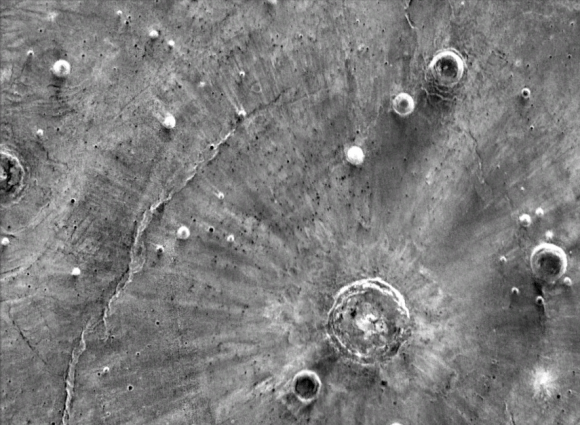
In some cases, these impact craters have strange bright streaks emanating from them, ones which reach much farther than basic ejecta patterns would allow. According to a new research study by a team from Brown University, these features are the result of large impacts that generated massive plumes. These would have interacted with Mars’ atmosphere, they argue, causing supersonic winds that scoured the surface.
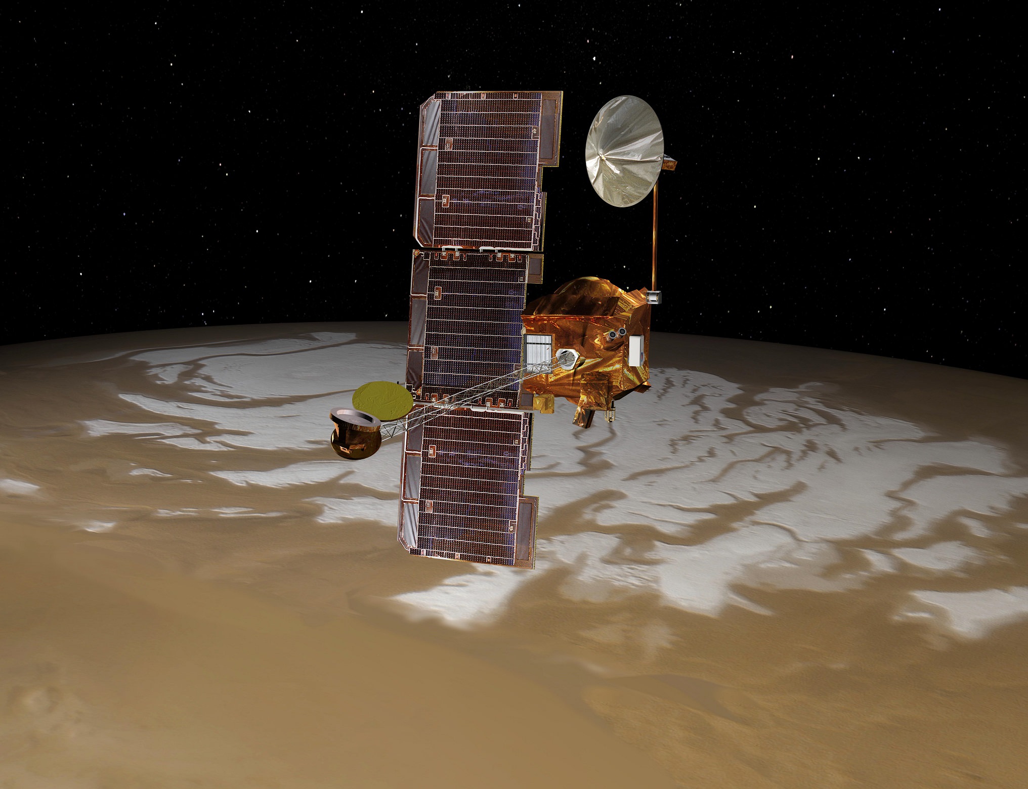
These features were noticed years ago by Professor Peter H. Schultz, a professor of geological science with the Department of Earth, Environmental, and Planetary Sciences (DEEPS) at Brown University. When studying images taken at night by the Mars Odyssey orbiter using its THEMIS instrument, he noticed steaks that only appeared when imaged in the infrared wavelength.
Artist’s conception of the Mars Odyssey spacecraft. Credit: NASA/JPL
These streaks were only visible in IR because it was only at this wavelength that contrasts in heat retention on the surface were visible. Essentially, brighter regions at night indicate surfaces that retain more heat during the day and take longer to cool. As Schultz explained in a Brown University press release, this allowed for features to be discerned that would otherwise not be noticed:
“You couldn’t see these things at all in visible wavelength images, but in the nighttime infrared they’re very bright. Brightness in the infrared indicates blocky surfaces, which retain more heat than surfaces covered by powder and debris. That tells us that something came along and scoured those surfaces bare.”
Along with Stephanie N. Quintana, a graduate student from DEEPS, the two began to consider other explanations that went beyond basic ejecta patterns. As they indicate in their study – which recently appeared in the journal Icarus under the title “Impact-generated winds on Mars” – this consisted of combining geological observations, laboratory impact experiments and computer modeling of impact processes.
Ultimately, Schultz and Quintana concluded that crater-forming impacts led to vortex-like storms that reached speeds of up to 800 km/h (500 mph) – in other words, the equivalent of an F8 tornado here on Earth. These storms would have scoured the surface and ultimately led to the observed streak patterns. This conclusion was based in part on work Schultz has done in the past at NASA’s Vertical Gun Range.
An infrared image revealing strange bright streaks extending from Santa Fe crater on Mars. Credit: NASA/JPL-Caltech/Arizona State University.
This high-powered cannon, which can fire projectiles at speeds up to 24,000 km/h (15,000 mph), is used to conduct impact experiments. These experiments have shown that during an impact event, vapor plumes travel outwards from the impact point (just above the surface) at incredible speeds. For the sake of their study, Schultz and Quintana scaled the size of the impacts up, to the point where they corresponded to the impact craters on Mars.
The results indicated that the vapor plume speed would be supersonic, and that its interaction with the Martian atmosphere would generate powerful winds. However, the plume and associated winds would not be responsible for the strange streaks themselves. Since they would be travelling just above the surface, they would not be capable of causing the kind of deep scouring that exists in the streaked areas.
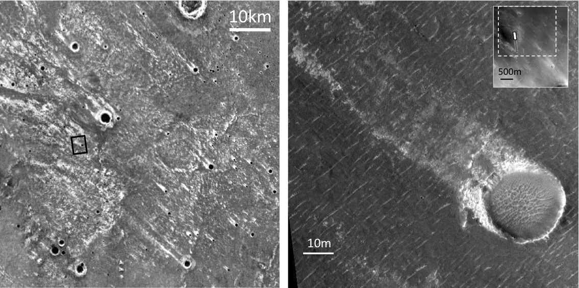
Instead, Schultz and Quintana showed that when the plume struck a raised surface feature – like the ridges of a smaller impact crater – it would create more powerful vortices that would then fall to the surface. It is these, according to their study, that are responsible for the scouring patterns they observed. This conclusion was based on the fact that bright streaks were almost always associated with the downward side of a crater rim.
IR images showing the correlation between the streaks and smaller craters that were in place when the larger crater was formed. Credit: NASA/JPL-Caltech/Arizona State University
As Schultz explained, the study of these streaks could prove useful in helping to establish that rate at which erosion and dust deposition occurs on the Martian surface in certain areas:
“Where these vortices encounter the surface, they sweep away the small particles that sit loose on the surface, exposing the bigger blocky material underneath, and that’s what gives us these streaks. We know these formed at the same time as these large craters, and we can date the age of the craters. So now we have a template for looking at erosion.”
In addition, these streaks could reveal additional information about the state of Mars during the time of impacts. For example, Schultz and Quintana noted that the streaks appear to form around craters that are about 20 km (12.4 mi) in diameter, but not always. Their experiments also revealed that the presence of volatile compounds (such as surface or subsurface water ice) would affect the amount of vapor generated by an impact.
In other words, the presence of streaks around some craters and not others could indicate where and when there was water ice on the Martian surface in the past. It has been known for some time that the disappearance of Mars’ atmosphere over the course of several hundred million years also resulted in the loss of its surface water. By being able to put dates to impact events, we might be able to learn more about Mars’ fateful transformation.
The study of these streaks could also be used to differentiate between the impacts of asteroids and comets on Mars – the latter of which would have had higher concentrations of water ice in them. Once again, detailed studies of Mars’ surface features are allowing scientists to construct a more detailed timeline of its evolution, thus determining how and when it became the cold, dry place we know today!
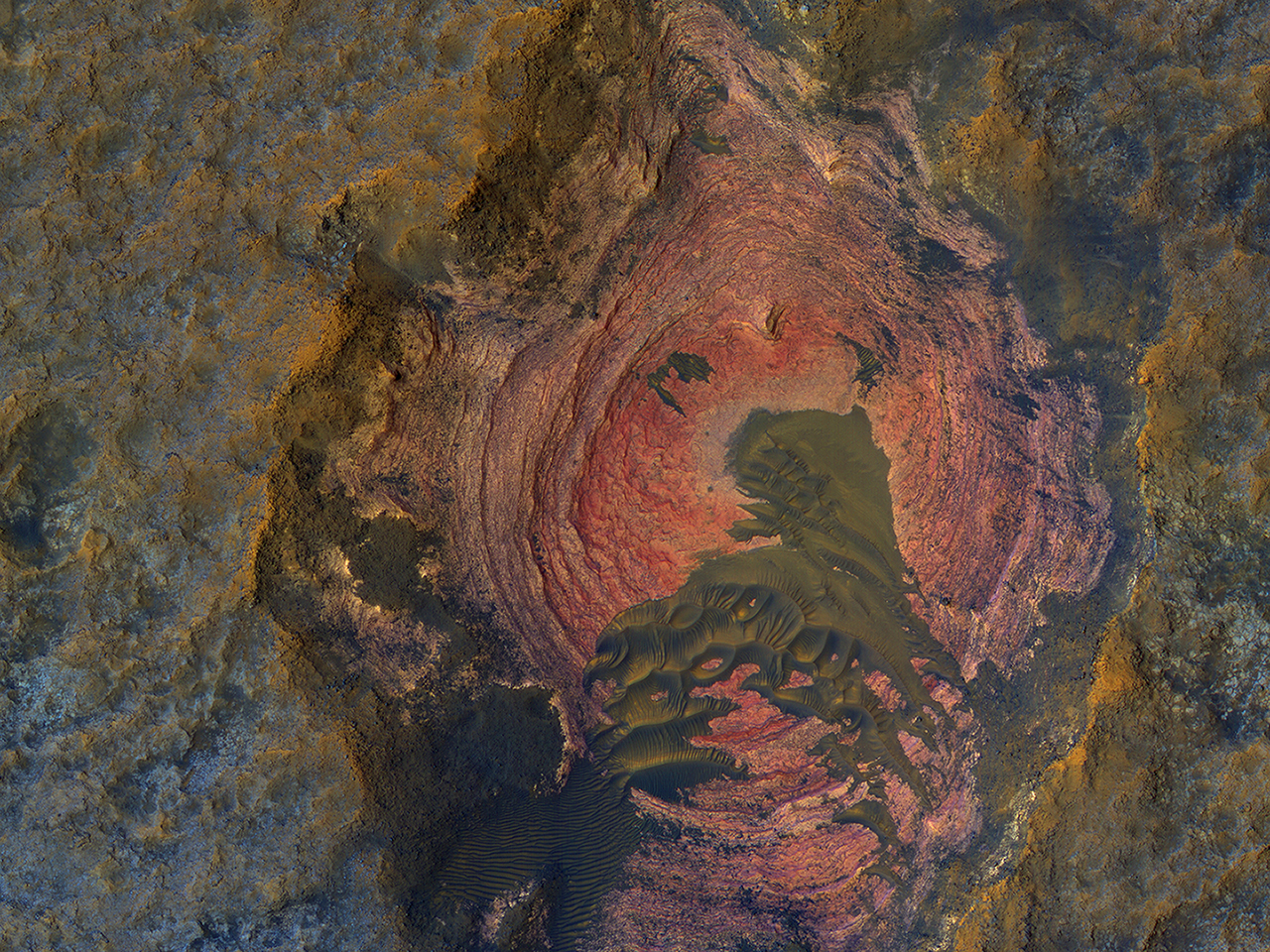
This colorful image of Martian bedrock, punctuated in the center by dunes, is courtesy of the HiRise camera aboard NASA's Mars Reconnaissance Orbiter. Image: NASA/JPL/University of Arizona
For a supposedly dead world, Mars sure provides a lot of eye candy. The High Resolution Imaging Science Experiment (HiRise) aboard NASA’s Mars Reconnaissance Orbiter (MRO) is our candy store for stunning images of Mars. Recently, HiRise gave us this stunning image (above) of colorful, layered bedrock on the surface of Mars. Notice the dunes in the center. The colors are enhanced, which makes the images more useful scientifically, but it’s still amazing.
HiRise has done it before, of course. It’s keen vision has fed us a steady stream of downright jaw-dropping images of Elon Musk’s favorite planet. Check out this image of Gale Crater taken by HiRise to celebrate its 10 year anniversary orbiting Mars. This image was captured in March 2016.
HiRise captured this image of unusual textures on the floor of the Gale Crater, the same crater where the Curiosity rover is working. Image: NASA/JPL-Caltech/Univ. of Arizona
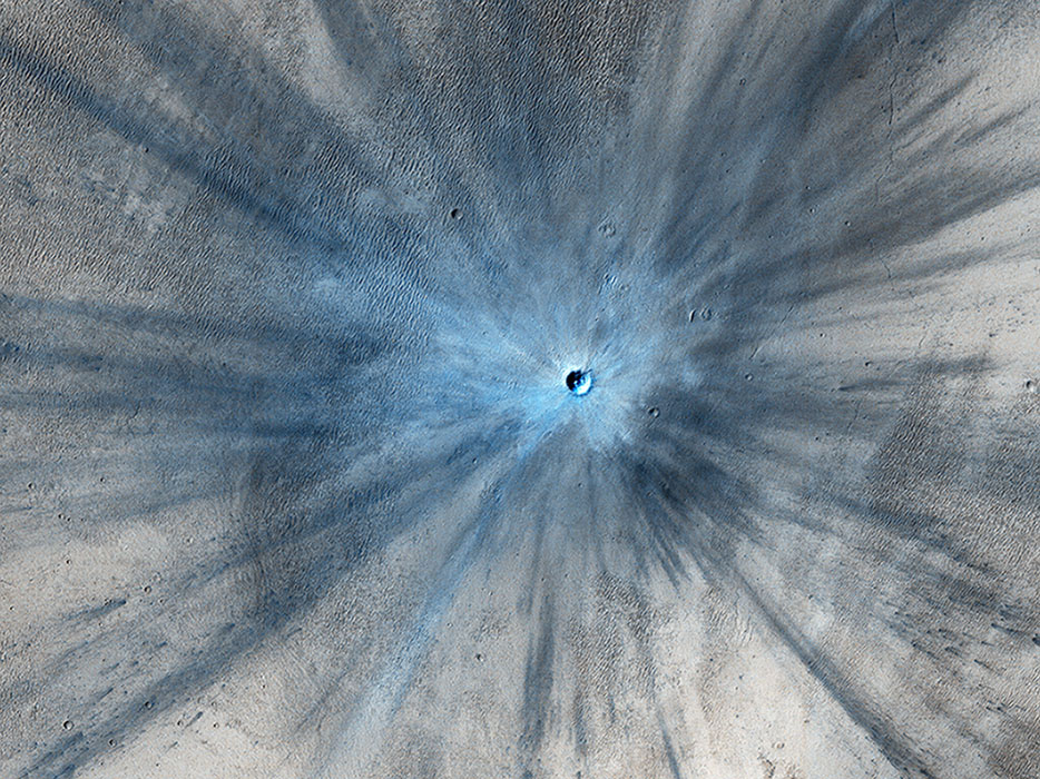
The MRO is approaching its 11 year anniversary around Mars. It has completed over 45,000 orbits and has taken over 216,000 images. The next image is of a fresh impact crater on the Martian surface that struck the planet sometime between July 2010 and May 2012. The impact was in a dusty area, and in this color-enhanced image the fresh crater looks blue because the impact removed the red dust.
This color-enhanced image of a fresh Martian crater was captured by the HiRise camera. Image: NASA/JPL-Caltech/Univ. of Arizona
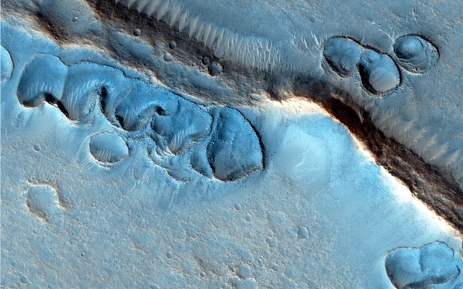
These landforms on the surface of Mars are still a bit of a mystery. It’s possible that they formed in the presence of an ancient Martian ocean, or perhaps glaciers. Whatever the case, they are mesmerizing to look at.
These odd ridges are still a mystery. Were they formed by glaciers? Oceans? Image: NASA/JPL-Caltech/Univ. of Arizona
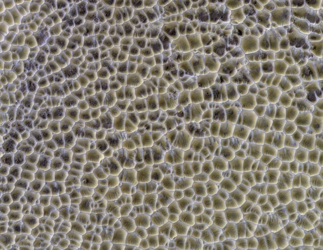
Many images of the Martian surface have confounded scientists, and some of them still do. But some, though they look puzzling and difficult to explain, have more prosaic explanations. The image below is a large area of intersecting sand dunes.
What is this? A vast area of Martian rice paddies? Lizard skin? Nope, just an area of intersecting sand dunes. Image: NASA/JPL-Caltech/Univ. of Arizona
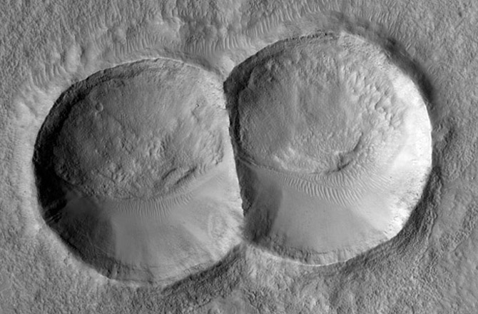
The surface of Mars is peppered with craters, and HiRise has imaged many of them. This double crater was caused by a meteorite that split in two before hitting the surface.
This double impact crater was caused by a meteorite that split into two before hitting Mars. Notice how the eroding force of the wind has shaped each crater the same, smoothing one edge and creating dunes in the same place. Image: NASA/JPL-Caltech/Univ. of Arizona
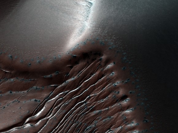
The image below shows gullies and dunes at the Russell Crater. In this image, the field of dunes is about 30 km long. This image was taken during the southern winter, when the carbon dioxide is frozen. You can see the frozen CO2 as white on the shaded side of the ridges. Scientists think that the gullies are formed when the CO2 melts in the summer.
These gullies are on the dunes of Russell Crater on Mars. This image was taken during winter, and the frozen carbon dioxide on the shaded slopes. Credit: NASA/JPL/University of Arizona
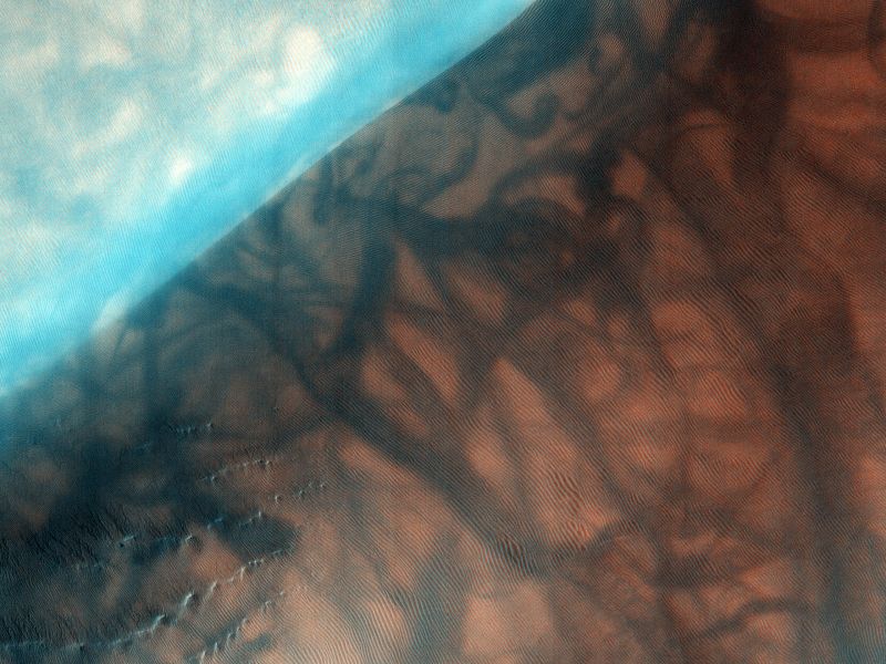
The next image is also the Russell Crater. It’s an area of study for the HiRise team, which means more Russell eye candy for us. This images shows the dunes, CO2 frost, and dust devil tracks that punctuate the area.
This image of the Russell Crater, an area of study for HiRise, shows the area covered in dunes, with some frost visible in the lower left. The larger, darker markings are dust devil tracks. Image: By NASA/JPL/University of Arizona – HiRISE, Public Domain, https://commons.wikimedia.org/w/index.php?curid=12015650
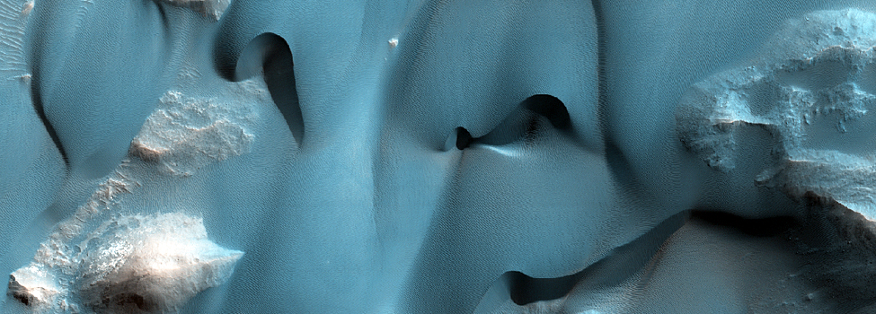
One of the main geological features on Mars is the Valles Marineris, the massive canyon system that dwarfs the Grand Canyon here on Earth. HiRise captured this image of delicate dune features inside Valles Marineris.
These delicate dune features formed inside the Valles Mariners, the massive canyon system on Mars. Image: NASA/JPL/University of Arizona
The Mars Reconnaissance Orbiter is still going strong. In fact, it continues to act as a communications relay for surface rovers. The HiRise camera is along for the ride, and if the past is any indication, it will continue to provide astounding images of Mars.
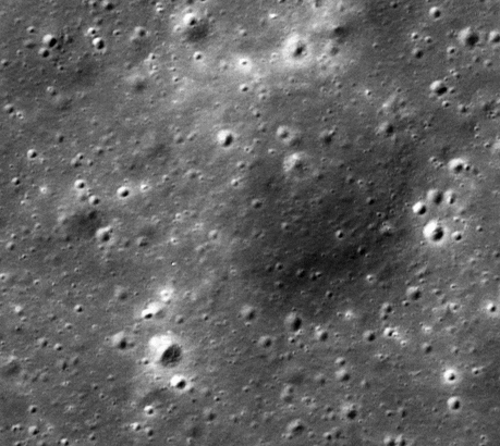
A brand new crater on the Moon! This new 12 meter (39 foot) diameter impact crater formed between 25 October 2012 and 21 April 2013 Credit: NASA/GSFC/Arizona State University].
Animation of a temporal pair of the new 39-foot (12-meter) impact crater on the moon photographed by NASA’s Lunar Reconnaissance Orbiter Credit: NASA/GSFC/Arizona State University
We often hear how the Moon’s appearance hasn’t changed in millions or even billions of years. While micrometeorites, cosmic rays and the solar wind slowly grind down lunar rocks, the Moon lacks erosional processes such as water, wind and lurching tectonic plates that can get the job done in a hurry.
One of a series of photos Apollo 11 astronaut Edwin Aldrin made of his bootprint in the dusty, sandy lunar soil, called regolith. Based on a newy study, the impression may disappear in a few tens of thousands of years instead a few million. Credit: NASA
Remember Buzz Aldrin’s photo of his boot print in the lunar regolith? It was thought the impression would last up to 2 million years. Now it seems that estimate may have to be revised based on photos taken by the Lunar Reconnaissance Orbiter (LRO) that reveal that impacts are transforming the surface much faster than previously thought.
This map shows the distribution of new impact craters (yellow dots) discovered by analyzing 14,000 narrow-angle camera (NAC) temporal pairs. The two red dots mark the location of the March 17, 2013 and September 11, 2013 impacts that were recorded by Earth-based video monitoring. LRO’s mission was recently extended an addition two years through September 2018. Credit: NASA/GSFC/ASUThe LRO’s high resolution camera, which can resolve features down to about 3 feet (1-meter) across, has been peering down at the Moon from orbit since 2009. Taking before and after images, called temporal pairs, scientists have identified 222 impact craters that formed over the past 7 years. The new craters range from 10 feet up to 141 feet (3-43 meters) in diameter.
By analyzing the number of new craters and their size, and the time between each temporal pair, a team of scientists from Arizona State University and Cornell estimated the current cratering rate on the Moon. The result, published in Nature this week, was unexpected: 33% more new craters with diameters of at least 30 feet (10 meters) were found than anticipated by previous cratering models.
LRO before and after images of an impact event on March 17, 2013. The newly formed crater is 59 feet (18 meters) in diameter. Subsurface regolith not exposed to sunlight forms a bright halo around the new crater. There also appears to be a larger nimbus of darker reflectance material visible much further beyond but centered on the impact. Credit: NASA/GSFC/Arizona State University
Similar to the crater that appeared on March 17, 2013 (above), the team also found that new impacts are surrounded by light and dark reflectance patterns related to material ejected during crater formation. Many of the larger impact craters show up to four distinct bright or dark reflectance zones. Nearest to the impact site, there are usually zone of both high and low reflectance. These two zones likely formed as a layer of material that was ejected from the crater during the impact shot outward to about 2½ crater diameters from the rim.
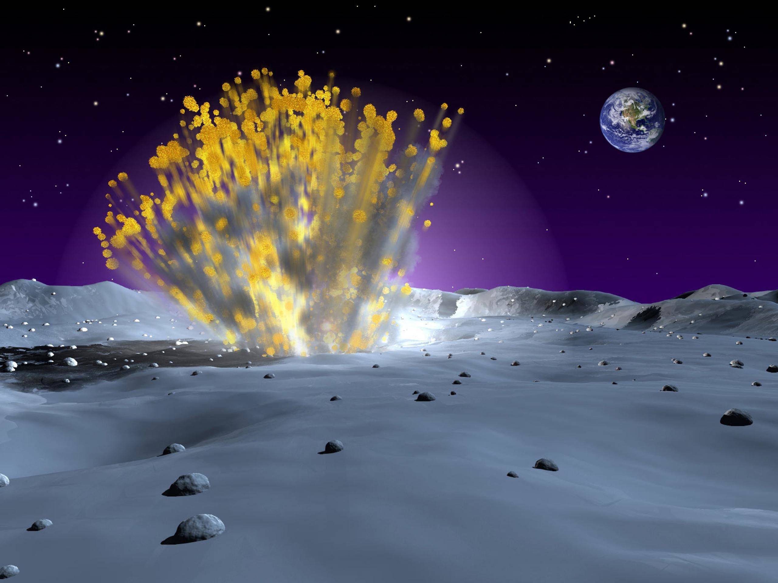
An artist’s illustration of a meteoroid impact on the Moon. Impacts dig up fresh material from below as well as send waves of hot rock vapor and molten rock across the lunar landscape, causing a much faster turnover of the moon soil than previously thought. Credit: NASA
From analyzing multiple impact sites, far flung ejecta patterns wrap around small obstacles like hills and crater rims, indicating the material was traveling nearly parallel to the ground. This kind of path is only possible if the material was ejected at very high speed around 10 miles per second or 36,000 miles per hour! The jet contains vaporized and molten rock that disturb the upper layer of lunar regolith, modifying its reflectance properties.
How LRO creates temporal pairs and scientists use them to discover changes on the moon’s surface.
In addition to discovering impact craters and their fascinating ejecta patterns, the scientists also observed a large number of small surface changes they call ‘splotches’ most likely caused by small, secondary impacts. Dense clusters of these splotches are found around new impact sites suggesting they may be secondary surface changes caused by material thrown out from a nearby primary impact. From 14,000 temporal pairs, the group identified over 47,000 splotches so far.
Here are two examples of a low reflectance (top) and high reflectance (bottom) splotch created either by a small impactor or more likely from secondary ejecta. In either case, the top few inches of the regolith (soil) was churned Credit: NASA/GSFC/Arizona State UniversityBased on estimates of size, depth and frequency of formation, the group estimated that the relentless churning caused by meteoroid impacts will turn over 99% of the lunar surface after about 81,000 years. Keep in mind, we’re talking about the upper regolith, not whole craters and mountain ranges. That’s more than 100 times faster than previous models that only took micrometeorites into account. Instead of millions of years for those astronaut boot prints and rover tracks to disappear, it now appears that they’ll be wiped clean in just tens of thousands!
A depression on Ceres is possibly what’s left of one of the largest craters from Ceres’ earliest collisional history. Credit: SwRI/Simone Marchi.
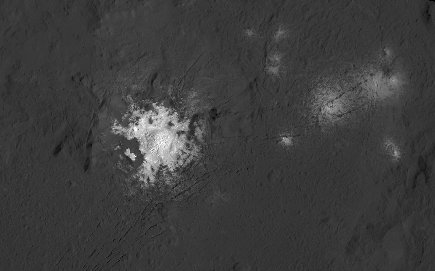
Scientists have found a bit of a mystery at the dwarf planet Ceres. Yes, there are those intriguing bright spots inside numerous craters, which is a mystery that has mostly been solved (the bright areas likely made of bright salts leftover from the sublimation of a briny solution of sodium carbonate and ammonium chloride; read more details in this NASA article.)
But a new puzzle involves the craters themselves. In the rough and tumble environment of the asteroid belt, ancient Ceres was certainly pummeled by numerous large asteroids during its 4.5 billion-year lifetime. But yet, there are just a few large craters on Ceres.
How could that be?
“It is as though Ceres cures its own large impact scars and regenerates new surfaces, over and over,” said Dr. Simone Marchi, a senior research scientist at the Southwest Research Institute.
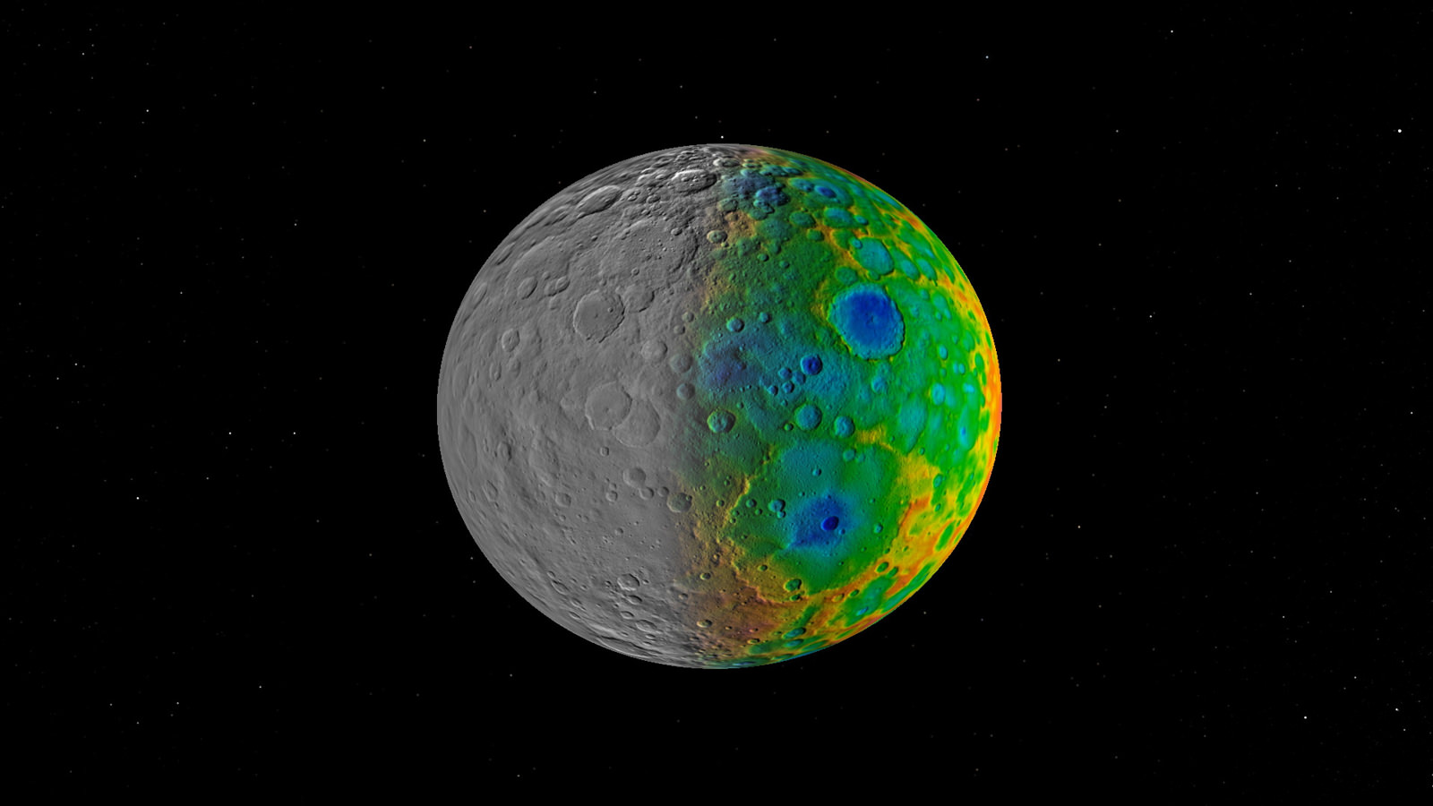
Scientists with NASA’s Dawn mission were surprised to find that Ceres has no clear signs of truly giant impact basins. This image shows both visible (left) and topographic (right) mapping data from Dawn. Credit: NASA/JPL-Caltech/SwRI.
Ceres has lots of little craters, but the Dawn spacecraft, orbiting Ceres since early 2015, has found only 16 craters larger than 100 km, and none larger than 280 km (175 miles) across. Scientists who model asteroid collisions in our Solar System predicted Ceres should have amassed up to 10 to 15 craters larger than 400 kilometers (250 miles) wide, and at least 40 craters larger than 100 km (62 miles) wide.
By comparison, Dawn’s other target of study, the smaller asteroid Vesta, has several large craters, including one 500 kilometers (300 miles) in diameter, covering almost the entire south pole region.
While they aren’t visible now, the scientists say there are clues that large impact basins may be hidden beneath Ceres’ surface.
“We concluded that a significant population of large craters on Ceres has been obliterated beyond recognition over geological time scales, likely the result of Ceres’ peculiar composition and internal evolution,” Marchi said.
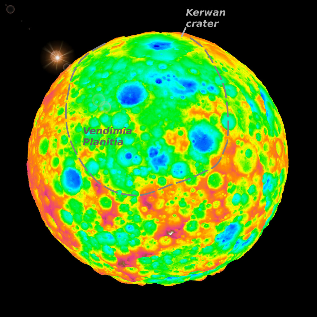
The top of this false-color image includes a grazing view of Kerwan, Ceres’ largest impact crater. This well-preserved crater is 280 km (175 miles) wide and is well defined with red-yellow high-elevation rims and a deep central depression shown in blue. Kerwan gradually degrades as one moves toward the center of the image into an 800-km (500-mile) wide, 4-km (2.5-mile) deep depression (in green) called Vendimia Planitia. This depression is possibly what’s left of one of the largest craters from Ceres’ earliest collisional history. Credit: SwRI/Simone Marchi.
There are hints of about three shallow depressions around 800 km (500 miles) wide, and Marchi said they could be what are called or planitiae, or ancient impact basins, left over from large collisions that took place early in Ceres’ history.
There are a few possible reasons why the big craters have been erased, and the scientists now have to figure out which reason or combination of reasons best explain their findings. One reason could be because of large amounts of water or ice in Ceres’ interior, which has long been suspected. Does the absence of large craters lend any insight into Ceres’ water content?
“It might,” Marchi said via email. “There is evidence for ice locally at the surface but it is not clear how much water ice there is in the subsurface.”
Marchi said the craters allow scientists to “probe” down to different depths, depending on their sizes, and that the missing large craters (greater than 100 km in diameter) can provide information on the properties on just the upper 100-200 km or so of Ceres’s outer shell.
Because ice is less dense than rock, the topography could “relax” over time — like what happens if you push on your skin, then take the pressure off, and it relaxes back to its original shape, although this happened extremely more slowly on Ceres. The scientists said that over geological timescales of several million years the water or ice would slowly flow and the craters would smooth out.
Additionally, recent analysis of the center of Ceres’ Occator Crater — where the largest bright areas are located — suggests that the salts found there could be remnants of a frozen ocean under the surface, and that liquid water could have been present in Ceres’ interior.
A recent paper constrains the amount of subsurface ice to be no more than 30-40%.
“However, the lack of large craters cannot be solely explained by the presence of 30-40% of water,” Marchi told Universe Today.
Another reason for the lack of large craters could be hydrothermal activity, such as geysers or cryovolcanoes, which could have flowed across the surface, possibly burying pre-existing large craters. Smaller impacts would have then created new craters on the resurfaced area. Hydrothermal activity has been linked to bright areas on Ceres, as well.
A close look at some of the craters on Ceres show cracked-like surfaces and other areas that looks like there was flow of the surface that “softened” some of the features. Marchi said the team is still working to clarify the Ceres’ peculiar composition and how cryolava or “low viscous material” could have caused the crater rims and bowls to “relax.”
The bright central spots near the center of Occator Crater are shown in enhanced color in this view from NASA’s Dawn spacecraft. The view was produced by combining the highest resolution images taken in February 2016 (at image scales 115 feet (35 meters) per pixel of 35 meters with color images obtained in September 2015 at a lower resolution. Click for a highest-res view. Credit: NASA/JPL-Caltech/UCLA/MPS/DLR/IDA/PSI
“This is still work in progress,” he told Universe Today. “Ceres is far more richer than Vesta in terms of smooth, flow features. Given that they are in the same environment (e.g. similar impact speed with asteroids), one would think that the production of impact melts would be the same. Thus the fact that we see more flow features on Ceres is a confirmation of its peculiar composition. This may facilitate production of impact “melt” (or ‘mud’ if there is enough water and clays).”
Another reason for the lack of large craters is that smaller, later impacts could have erased the bigger older impact basins. But if that were the case, the older basins would seemingly be more visible than they are now.
But the answer to this puzzle might all come back to the intriguing bright areas on Ceres.
“The presence of ammoniated phyllosilicates, carbonates and salts is truly amazing,” Marchi said. “I think this peculiar composition and Ceres’ internal structure are responsible for the lack of large craters, although we do not know precisely what the obliteration mechanism is.”
Marchi said the large crater obliteration was active well after the late heavy bombardment era, or about 4 billion year ago, so the resurfacing is inextricably linked to Ceres itself and its internal evolution, not impact events.
“All this shows over and over how peculiar Ceres is,” Marchi said. “Beside being a transition object (at inner/outer solar system boundary), it is peculiar in composition, and now also in cratering record.”
Finding out more about Ceres’ interior is one of the more intriguing aspects of Dawn’s continued mission there.
A six degree True Polar Wander occurred on the Moon due to ancient volcanic activity. Image: University of Arizona/James Tuttle Keane
It’s tempting to think that the Moon never changes. You can spend your whole life looking at it, and see no evidence of change whatsoever. In fact, the ancients thought the whole Universe was unchanging.
You may have heard of a man named Aristotle. He thought the Universe was eternal and unchanging. Obviously, with our knowledge of the Big Bang, stellar evolution, and planetary formation, we know better. Still, the placid and unchanging face of the Moon can tempt us into thinking astronomers are making up all this evolving universe stuff.
But now, according to a new paper in Nature, the Moon’s axis of rotation is different now than it was billions of years ago. Not only that, but volcanoes may been responsible for it. Volcanoes! On our placid little Moon.
The clue to this lunar True Polar Wander (TPW) is in the water ice locked in the shadows of craters on the Moon. When hydrogen was discovered on the surface of the Moon in the 1990s by the Lunar Prospector probe, scientists suspected that they would eventually find water ice. Subsequent missions proved the presence of water ice, especially in craters near the polar regions. But the distribution of that water-ice wasn’t uniform.
You would expect to see ice uniformly distributed in the shadows of craters in the polar regions, but that’s not what scientists have found. Instead, some craters had no evidence of ice at all, which led the team behind this paper to conclude that these ice-free craters must have been exposed to the Sun at some point. What else would explain it?
The way that the ice in these craters is distributed forms two trails that lead away from each pole. They’re mirror images of each other, but they don’t conform with the Moon’s current axis of rotation, which is what led the team to conclude that the Moon underwent a 6 degree TPW billions of years ago.
The paper also highlights the age of the water on the Moon. Since the TPW, and the melting of some of the ice as a result of it, occurred some billions of years ago, then the water ice that is still frozen in the shadows of some of the Moon’s craters must be ancient. According to the paper, its existence records the “early delivery of water to the inner Solar System.” Hopefully, a future mission will return a sample of this ancient water for detailed study.
But even more interesting than the age of the ice in the craters and the TPW, to me anyways, is what is purported to have caused it. The team behind the paper reports that volcanic activity on the Moon in the Procellarum region, which was most active in the early history of the Moon, moved a substantial amount of material and “altered the density structure of the Moon.” This alteration would have changed the moments of inertia on the Moon, resulting in a TPW.
It’s strange to think of the Moon with volcanic activity viewable from Earth. I wonder what effect visible lunar volcanoes would have had on thinkers like Aristotle, if lunar volcanic activity had occurred during recorded history, rather than ending one billion years ago or so.
We know that events like eclipses and comets caused great confusion and sometimes upheaval in ancient civilizations. Would lunar volcanoes have had the same effect?
Callisto has many more craters than Europa and a thicker icy crust. Image credit: NASA/JPL
With 67 confirmed satellites, Jupiter has the largest system of moons in the Solar System. The greatest of these are the four major moons of Io, Europa, Ganymede and Callisto – otherwise known as the Galilean Moons. Named in honor of their founder, these moons are not only comparable in size to some planets (such as Mercury), they are also some of the few places outside of Earth where liquid water exists, and perhaps even life.
But it is Callisto, the fourth and farthest moon of Jupiter, that may be the most rewarding when it comes to scientific research. In addition to the possibility of a subsurface ocean, this moon is the only Galilean far enough outside of Jupiter’s powerful magnetosphere that it does not experience harmful levels of radiation. This, and the prospect of finding life, make Callisto a prime candidate for future exploration.
Discovery and Naming:
Along with Io, Europa and Ganymede, Callisto was discovered in January of 1610 by Galileo Galilei using a telescope of his own design. Like all the Galilean Moons, it takes its name from one of Zeus’ lovers in classic Greek mythology. Callisto was a nymph (or the daughter of Lycaon) who was associated with the goddess of the hunt, Artemis.
The name was suggested by German astronomer Simon Marius, apparently at the behest of Johannes Kepler. However, Galileo initially refused to use them, and the moons named in his honor were designed as Jupiter I through IV, based on their proximity to their parent planet. Being the farthest planet from Jupiter, Callisto was known as Jupiter IV until the 20th century, by which time, the names suggested by Marius were adopted.
The Galilean moons to scale, with Callisto in the bottom left corner. Credit: NASA/JPL
Size, Mass and Orbit:
With a mean radius of 2410.3 ± 1.5 km (0.378 Earths) and a mass of 1.0759 × 10²³ kg (0.018 Earths), Callisto is the second largest Jupiter’s moons (after Ganymede) and the third largest satellite in the solar system. Much like Ganymede, it is comparable in size to Mercury – being 99% as large – but due to its mixed composition, it has less than one-third of Mercury mass.
Callisto orbits Jupiter at an average distance (semi-major axis) of 1,882,700 km. It has a very minor eccentricity (0.0074) and ranges in distance from 1,869,000 km at periapsis to 1,897,000 km at apoapsis. This distance, which is far greater than Ganymede’s, means that Callisto does not take part in the mean-motion resonance that Io, Europa and Ganymede do.
Much like the other Galileans, Callisto’s rotation is synchronous with its orbit. This means that it takes the same amount of time (16.689 days) for Callisto to complete a single orbit of Jupiter and a single rotation on its axis. Its orbit is very slightly eccentric and inclined to the Jovian equator, with the eccentricity and inclination changing over the course of centuries due to solar and planetary gravitational perturbations.
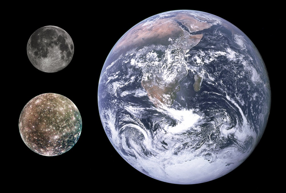
Size comparison of Earth, Moon and Callisto. Credit: NASA/JPL/DLR/Gregory H. Revera
Unlike the other Galileans, Callisto’s distant orbit means that it has never experienced much in the way of tidal-heating, which has had a profound impact on its internal structure and evolution. Its distance from Jupiter also means that the charged particles from Jupiter’s magnetosphere have had a very minor influence on its surface.
Composition and Surface Features:
The average density of Callisto, at 1.83 g/cm3, suggests a composition of approximately equal parts of rocky material and water ice, with some additional volatile ices such as ammonia. Ice is believed to constitute 49-55% of the moon, with the rock component likely made up of chondrites, silicates and iron oxide.
Callisto’s surface composition is thought to be similar to its composition as a whole, with water ice constituting 25-50% of its overall mass. High-resolution, near-infrared and UV spectra imaging have revealed the presence of various non-ice materials, such as magnesium and iron-bearing hydrated silicates, carbon dioxide, sulfur dioxide, and possibly ammonia and various organic compounds.
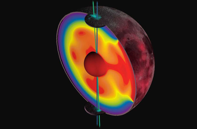
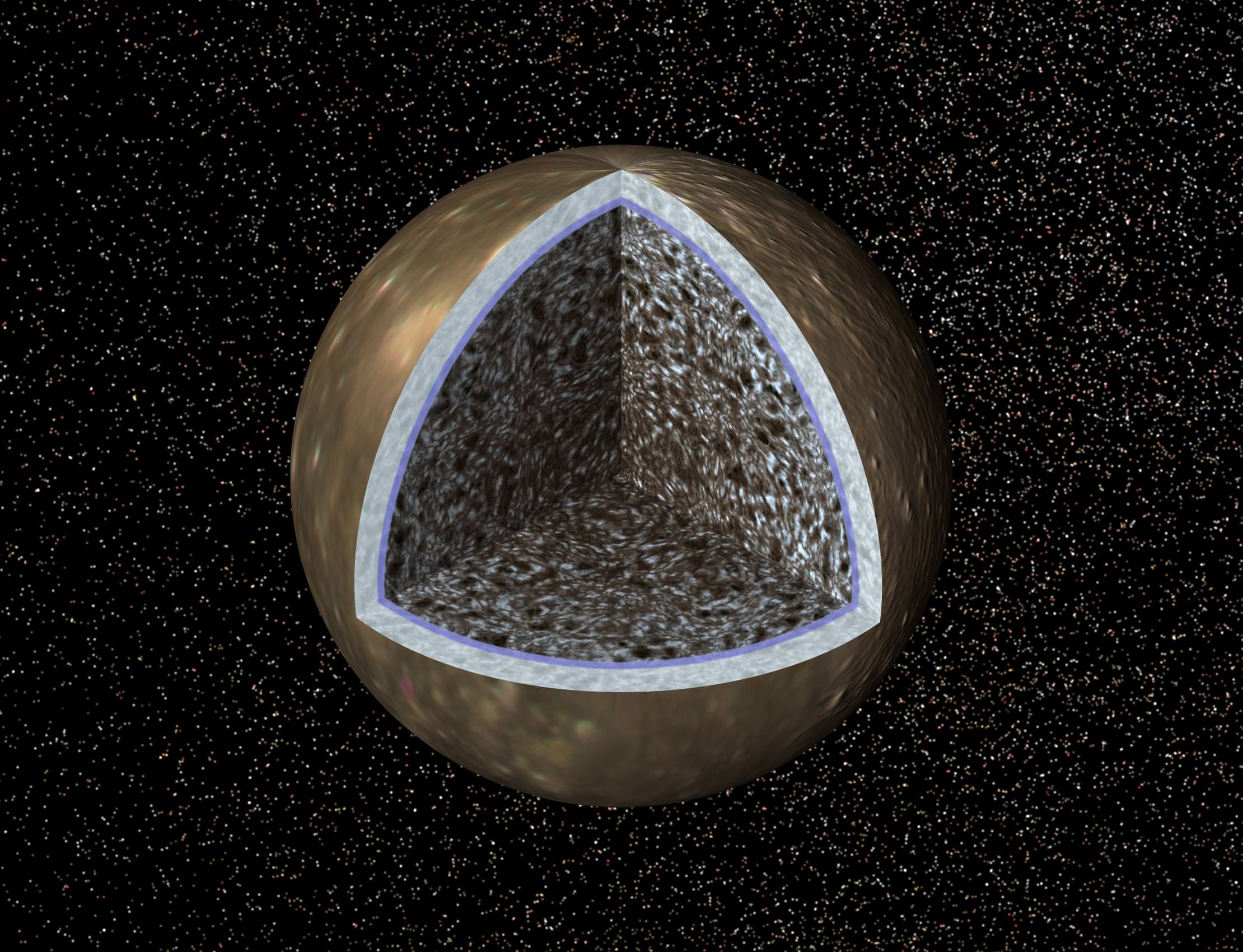
Model of Callisto’s internal structure showing a surface ice layer, a possible liquid water layer, and an ice–rock interior. Credit: NASA/JPL
Beneath the surface is an icy lithosphere that is between 80-150 m thick. A salty ocean 50–200 km deep is believed to exist beneath this, thanks to the presence of radioactive elements and the possible existence of ammonia. Evidence of this ocean include Jupiter’s magnetic field, which shows no signs of penetrating Callisto’s surface. This suggests a layer of highly conductive fluid that is at least 10 km in depth. However, if this water contains ammonia, which is more likely, than it could be up to 250-300 km.
Beneath this hypothetical ocean, Callisto’s interior appears to be composed of compressed rocks and ices, with the amount of rock increasing with depth. This means, in effect, that Callisto is only partially differentiated, with a small silicate core no larger than 600 km (and a density of 3.1-3.6 g/cm³) surrounded by a mix of ice and rock.
Spectral data has also indicated that Callisto’s surface is extremely heterogeneous at the small scale. Basically, the surface consists of small, bright patches of pure water ice, intermixed with patches of a rock–ice mixture, and extended dark areas made of a non-ice material.
Compared to the other Galilean Moons, Callisto’s surface is quite dark, with a surface albedo of about 20%. Another difference is the nature of its asymmetric appearance. Whereas with the other Galileans, the leading hemisphere is lighter than the trailing one, with Callisto the opposite is true.
Interior density structures created by an outer solar system late heavy bombardment onto Ganymede (top row) and Callisto (bottom row). Credit: SwRI
An immediately obvious feature about Callisto’s surface is the ancient and heavily cratered nature of it. In fact, the surface is the most cratered in the Solar System and is almost entirely saturated by craters, with newer ones having formed over older ones. What’s more, impact craters and their associated structures are the only large features on the surface. There are no mountains, volcanoes or other endogenic tectonic features.
Callisto’s impact craters range in size from 0.1 km to over 100 km, not counting the multi-ring structures. Small craters, with diameters less than 5 km, have simple bowl or flat-floored shapes, whereas those that measure 5–40 km usually have a central peak.
Larger impact features, with diameters that range from 25–100 km have central pits instead of peaks. Those with diameters over 60 km can have central domes, which are thought to result from central tectonic uplift after an impact.
The largest impact features on Callisto’s surface are multi-ring basins, which probably originated as a result of post-impact concentric fracturing which took place over a patch of lithosphere that overlay a section of soft or liquid material (possibly a patch of the interior ocean). The largest of these are Valhalla and Asgard, whose central, bright regions measure 600 and 1600 km in diameter (respectively) with rings extending farther outwards.
Voyager 1 image of Valhalla, a multi-ring impact structure 3800 km in diameter. Credit: NASA/JPL
The relative ages of the different surface units on Callisto can be determined from the density of impact craters on them – the older the surface, the denser the crater population. Based on theoretical considerations, the cratered plains are thought to be ~4.5 billion years old, dating back almost to the formation of the Solar System.
The ages of multi-ring structures and impact craters depend on chosen background cratering rates, and are estimated by different researchers to vary between 1 and 4 billion years of age.
Atmosphere:
Callisto has a very tenuous atmosphere composed of carbon dioxide which has an estimated surface pressure of 7.5 × 10-¹² bar (0.75 micro Pascals) and a particle density of 4 × 108 cm-3. Because such a thin atmosphere would be lost in only about 4 days, it must be constantly replenished, possibly by slow sublimation of carbon dioxide ice from Callisto’s icy crust.
While it has not been directly detected, it is believed that molecular oxygen exists in concentrations 10-100 times greater than CO². This is evidenced by the high electron density of the planet’s ionosphere, which cannot be explained by the photoionization of carbon dioxide alone. However, condensed oxygen has been detected on the surface of Callisto, trapped within its icy crust.
Habitability:
Much like Europa and Ganymede, and Saturn’s moons of Enceladus, Mimas, Dione, Titan, the possible existence of a subsurface ocean on Callisto has led many scientists to speculate about the possibility of life. This is particularly likely if the interior ocean is made up of salt-water, since halophiles (which thrive in high salt concentrations) could live there.
In addition, the possibility of extra-terrestrial microbial life has also been raised with respect to Callisto. However, the environmental conditions necessary for life to appear (which include the presence of sufficient heat due to tidal flexing) are more likely on Europa and Ganymede. The main difference is the lack of contact between the rocky material and the interior ocean, as well as the lower heat flux in Callisto’s interior.
In essence, while Callisto possesses the necessary pre-biotic chemistry to host life, it lacks the necessary energy. Because of this, the most likely candidate for the existence of extra-terrestrial life in Jupiter’s system of moons remains Europa.
Exploration:
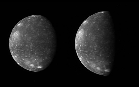
The first exploration missions to Callisto were the Pioneer 10 and 11 spacecrafts, which conducted flybys of the Galilean moon in 1973 and 1974, respectively, But these missions provided little additional information beyond what had already learned through Earth-based observations. In contrast, the Voyager 1 and 2 spacecraft, which conducted flybys of the moon in 1979, managed to image more than half the surface and precisely measured Callisto’s temperature, mass and shape.
New Horizons Long Range Reconnaissance Imager (LORRI) captured these two images of Jupiter’s outermost large moon, Callisto, during its flyby in February 2007. Credit: NASA/JPL
Further exploration took place between 1994 and 2003, when the Galileo spacecraft performed eight close flybys with Callisto. The orbiter completed the global imaging of the surface and delivered a number of pictures with a resolution as high as 15 meters. In 2000, while en route to Saturn, the Cassini spacecraft acquired high-quality infrared spectra of the Galilean satellites, including Callisto.
In February–March 2007, while en route to Pluto, the New Horizons probe obtained new images and spectra of Callisto. Using its Linear Etalon Imaging Spectral Array (LEISA) instrument, the probe was able to reveal how lighting and viewing conditions affect infrared spectrum readings of its surface water ice.
The next planned mission to the Jovian system is the European Space Agency’s Jupiter Icy Moon Explorer (JUICE), due to launch in 2022. Ostensibly geared towards exploring Europa and Ganymede, the mission profile also includes several close flybys of Callisto.
Colonization:
Compared to the other Galileans, Callisto presents numerous advantages as far as colonization is concerned. Much like the others, the moon has an abundant supply of water in the form of surface ice (but also possibly liquid water beneath the surface). But unlike the others, Callisto’s distance from Jupiter means that colonists would have far less to worry about in terms of radiation.
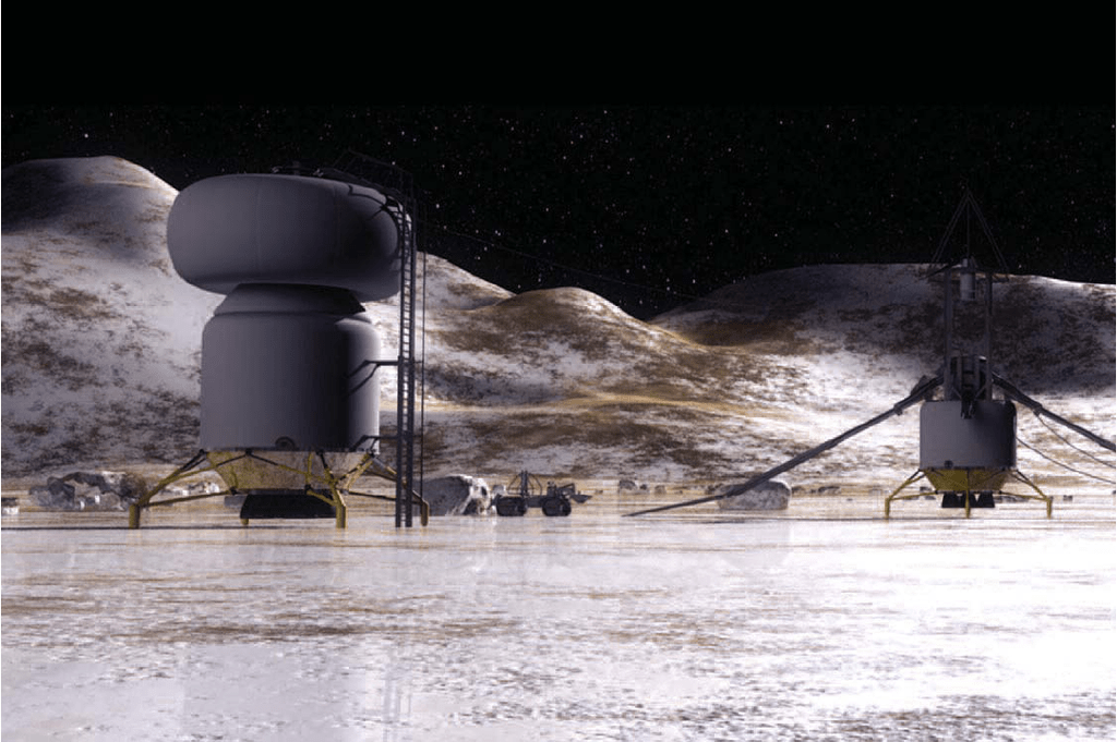
In 2003, NASA conducted a conceptual study called Human Outer Planets Exploration (HOPE) regarding the future human exploration of the outer Solar System. The target chosen to consider in detail was Callisto, for the purposes of investigating the possible existence of life forms embedded in the ice crust on this moon and on Europa.
Artist’s impression of a base on the icy surface of Callisto. Credit: NASA
The study proposed a possible surface base on Callisto where a crew could “teleoperate a Europa submarine and excavate Callisto surface samples near the impact site”. In addition, this base could extract water from Callisto’s ample supply of water ices to produce rocket propellant for further exploration of the Solar System.
The advantages of a base on Callisto include low radiation (due to its distance from Jupiter) and geological stability. Such a base could facilitate exploration on other Galilean Moons, and be an ideal location for a Jovian system way station, servicing spacecraft heading farther into the outer Solar System – which would likely take the form of craft using a gravity assist from a close flyby of Jupiter.
Reports filed by NASA’s Glenn Research Center and Langley Research Center – in December and February of 2003, respectively – both outlined possible manned missions to Callisto, as envisioned by HOPE. According to these reports, a mission that would likely involve a ship using a Mangetoplasmadynamic (MPD) or Nuclear-Electric Propulsion (NEP) drive system, and equipped to generate artificial gravity, could be mounted in the 2040s.
So while Callisto may not be the best target in the search for extra-terrestrial life, it may be the most hospitable of Jupiter’s moons for human life. In either case, any future missions to Jupiter will likely include a stopovers to Callisto, with the intent of investigating both of these possibilities.
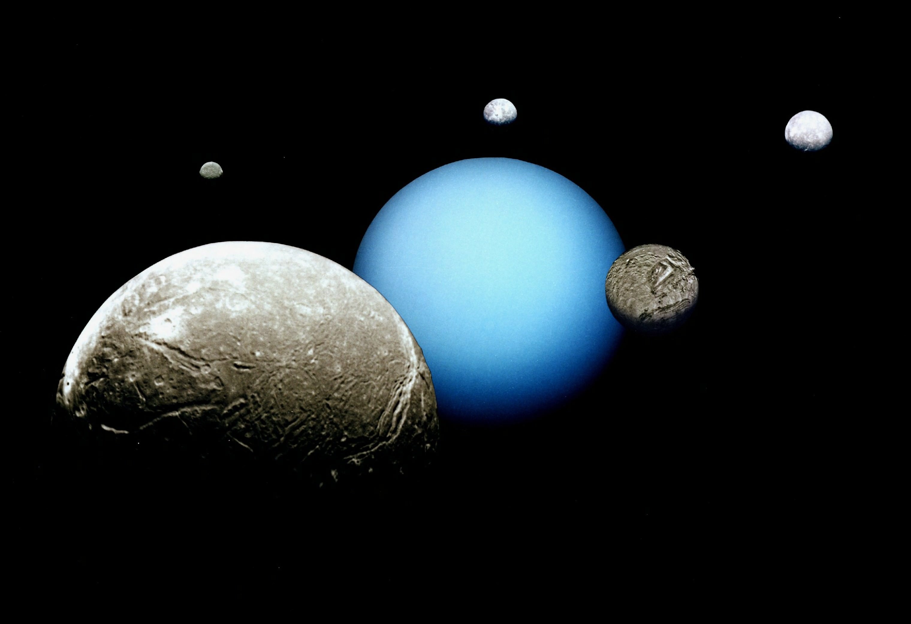
The 19th century was an auspicious time for astronomers and planet hunters. In addition to the discovery of the Asteroid Belt that rests between Mars and Jupiter – as well as the many minor planets within – the outer solar planet of Uranus and its series of moons were also observed for the very first time.
Of these, Umbriel was certainly one of the most interesting finds. Aside from being Uranus’ third largest moon, it is also its darkest – a trait which contributed greatly to the selection of its name. And to this day, this large satellite of Uranus is shrouded in mystery…
Discovery and Naming:
Umbriel, along with its fellow moon Ariel, was discovered by English astronomer William Lassell on October 24th, 1851. Fellow English astronomer William Herschel, who had discovered Uranus’ moons of Titania and Oberon at the end of the 18th century, also claimed to have observed four additional moons around Uranus. However, his observations were not confirmed, leaving the confirmed discoveries of Ariel and Umbriel to Lassell, roughly half a century later.
Much like all of Uranus’ 27 moons, Umbriel was named after a character from Alexander Pope’s The Rape of the Lock, as well as plays by William Shakespeare. These names were suggested by John Herschel, the son of William Herschel, when he announced the discoveries of Titania and Oberon.
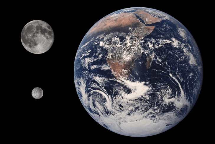
Size comparison of Earth, the Moon, and Umbriel. Credit: Tom Reding/Public Domain
In keeping with the moon’s dark appearance, the name Umbriel – which was the name of the ‘dusky melancholy sprite’ in the The Rape of the Lock and is derived from the Latin Umbra (which means “shadow”) – seemed most appropriate for this satellite.
Size, Mass and Orbit:
Ariel and Umbriel are nearly the same size, with diameters of 1,158 kilometers and 1,170 kilometers respectively. Based on spectrograph analyses and estimates of the moon’s mass and density, astronomers believe that the majority of the planet consists of water ice, with a dense non-ice component constituting around 40% of its mass.
This could mean that Umbriel consists of an icy outer shell that surrounds a rocky core, or one made out of carbonaceous materials. It also means that though Umbriel is the third largest moon of Uranus, it is only the fourth largest in terms of mass. Furthermore, its dark appearance is believed to be the result of the interactions of surface water ice with energetic particles from Uranus’ magnetosphere.
These energetic particles would cause methane deposits (trapped in the ice as clathrate hydrate) to decompose and other organic molecules to darken, leaving behind a dark, carbon-rich residue. The satellite’s dark color is also due to its very low bond albedo – which is basically the amount of electromagnetic radiation (i.e. light) that gets reflected back from the surface.
So far, spectrographic analyses have only confirmed the existence of water and carbon dioxide. So the existence of organic particles or methane deposits in the ice remains theoretical. However, their presence would explain the prevalence of CO² and why it is concentrated mainly on the trailing hemisphere.
Umbriel’s orbital period – i.e. the time it takes the moon to orbit Uranus – is approximately 4.1 days, which is coincident with its rotational period. This means that the moon is a synchronous and tidally-locked satellite, with one face always pointing towards Uranus. The satellite is at an average distance of 266,000 kilometers from its planet, which makes it the third farthest from Uranus, behind Miranda and Ariel.
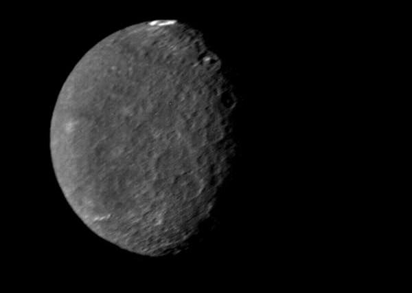
Voyager 2:
So far, the only close-up images of Umbriel have been provided by the Voyager 2 probe, which photographed the moon during its flyby of Uranus in January of 1986. During this flyby, the closest distance between Voyager 2 and Umbriel was 325,000 km (202,000 mi).
The images cover about 40% of the surface, but only 20% was photographed with the quality required for geological mapping. At the time of the flyby, the southern hemisphere of Umbriel was pointed towards the Sun – so the northern, darkened hemisphere could not be studied. At present, no future missions are planned to study the moon in greater detail.
US Geological Survey map of Umbriel, showing its cratered surface and polygons. Credit: ISGS
Interesting Facts:
The surface of Umbriel has far more and larger craters than do Ariel and Titania, ranging in diameter from a few kilometers to several hundred. The largest known crater on the surface is Wokolo, which is 210 km in diameter. Wunda, a crater with a diameter of about 131 kilometers, is the most noticeable surface feature, due to the ring of bright material on its floor (which scientists think are from the impact).
Other craters include Fin, Peri, and Zlyden which, like all of Umbriel’s surface features, are named after dark sprites from different cultures’ mythology. The only satellite of Uranus to have more craters is Oberon, and the planet is believed to be geologically stable.
It is further believes that surface has probably been stable since the Late Heavy Bombardment. The only signs of ancient internal activity are canyons and dark polygons – dark patches with complex shapes measuring from tens to hundreds of kilometers across. The polygons were identified from precise photometry of Voyager 2′s images and are distributed more or less uniformly on the surface of Umbriel, trending northeast – southwest.
Because Uranus orbits the Sun almost on its side, it is subject to an extreme seasonal cycle. Both northern and southern poles spend 42 years in complete darkness, and another 42 years in continuous sunlight, with the Sun rising close to the zenith over one of the poles at each solstice.
The southern hemisphere of Umbriel displays heavy cratering in this Voyager 2 image, taken Jan. 24, 1986. The large impact crater of Wunda is visible at the top. Credit: NASA/JPL
Because they are in the planet’s equatorial plane, Uranus’ satellites also experience these changes. This means that Umbriel’s north and south poles spend 42 years in light and then 42 years in darkness before repeating the cycle. In fact, the Voyager 2 flyby coincided with the southern hemisphere’s 1986 summer solstice, when nearly the entire northern hemisphere was in darkness.
Interesting little moon isn’t it? Even though no missions are currently planned to observe it in the coming years, one can only hope that future satellites happen to sneak a peek at it on their way to some other destination in the outer Solar System.
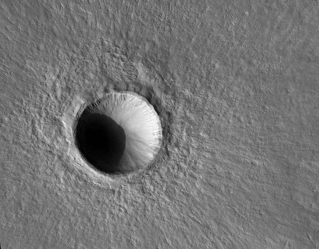
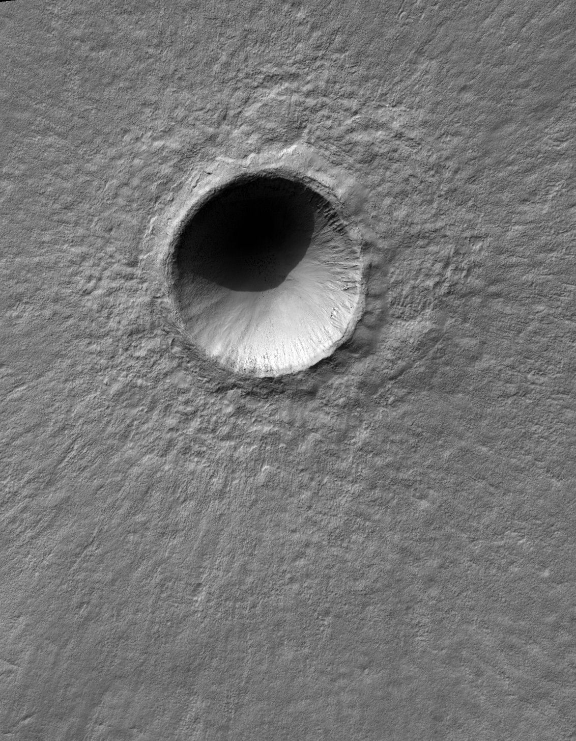
A 'new' fresh 1-km wide crater on Mars, captured by the HiRISE camera on the Mar Reconnaissance Orbiter. Or does it look like a mountain to you? Credit: NASA/JPL/University of Arizona.
Yesterday, we posted an image taken by the HiRISE camera on the Mars Reconnaissance Orbiter (MRO) of an unusual crater formed by a triple-asteroid. We noticed some comments on the article and on social media of people who said, “hey, that looks like a mountain, not a crater!”
Thanks to our brains, this is a common illusion! Depending on the angle of the Sun when the picture was taken, images of craters taken from overhead (i.e. from orbit) may appear to be a mountain. Here on Earth, we’re used to seeing sunlight coming from overhead, and our brain interprets what we see with the assumption that the sunlight *must* always come from above. Satellite photos of terrain, however usually only show shadows when the light source is nearly horizontal with the surface.
There’s an easy fix for this illusion: flip the image over so it appears the sunlight is coming from above. We’ve done that for you, below:
The same 1-km fresh crater on Mars, but with the image upside down. Credit: NASA/JPL/University of Arizona.
When a crater is illuminated from above, the shadow inside the crater is near the top and the bright part is near the bottom. A mountain shows exactly the opposite lighting pattern: bright at the top and shadowed at the bottom. This is because the part of the crater or mountain that is most perpendicular to the incoming light reflects it the best. Anyway, your brain interprets pictures under the assumption that the light is from the top of the scene. So if a picture shows an object that is bright at the top and dark at the bottom, it interprets it as a mound lit from above, not as a crater lit from below.
We do know that any photo of anything that is concave or convex will flip in its appearance if the photo is turned upside down. Take a look at any of these crater images from HiRISE, and you’ll likely be deceived on most of them! (remember, they are ALL craters!)
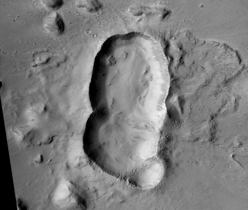
And here’s the image from yesterday:
A triple crater in Elysium Planitia on Mars. Credit: NASA/JPL/University of Arizona.
A triple crater in Elysium Planitia on Mars. Credit: NASA/JPL/University of Arizona.
At first glance, you many not guess that this feature on Mars is an impact crater. The reason it looks so unusual is that it likely is a triple impact crater, formed when three asteroids struck all at once in the Elysium Planitia region.
Why do planetary scientists think the three craters did not form independently at different times?
“The ejecta blanket appears to be uniform around the triple-crater showing no signs of burial or overlapping ejecta from overprinting craters,” write scientists Eric Pilles, Livio Tornabene, Ryan Hopkins, and Kayle Hansen on the HiRISE website. “The crater rims are significantly stunted where the craters overlap.”
This oblong-shaped crater could have been created from a triple asteroid, or it could have been a binary asteroid, and one broke apart, creating the three overlapping craters. The team says the two larger craters must have been produced by asteroids of approximately the same size, probably on the order of a few hundred meters across.
“The northern crater might have been created by a smaller asteroid, which was orbiting the larger binary pair, or when one of the binary asteroids broke up upon entering the atmosphere,” the team explained. “The shape of the triple-crater is oblong, suggesting an oblique impact; therefore, another alternative would be that the asteroid split upon impact and ricocheted across the surface, creating additional craters.”
Studying craters on Mars — and there are lots of them, thanks to Mars’ sparse atmosphere — can help estimate the ages of different terrains, as well as revealing materials such as ice or minerals that get exposed from the impact.
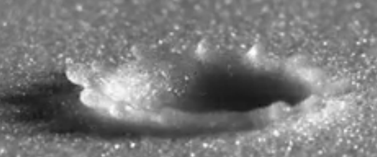
Close-up view of a raindrop falling on a granular surface, which produces effects similar to an asteroid collision (but on a much smaller scale). Credit: Xiang Cheng, University of Minnesota et al./APS Physics/YouTube (screenshot)
It’s hard to study what an asteroid impact does real-time as you’d need to be looking at the right spot at the right time. So simulations are often the way to go. Here’s a fun idea captured on video — throwing drops of water on to granular particles, similar to what you would find on a beach. The results, the researchers say, look surprisingly similar to “crater morphology”.
A quick caution — the similarity isn’t completely perfect. Raindrops are much smaller, and hit the ground at quite a lower speed than you would see an asteroid slam into Earth’s surface. But as the authors explain in a recent abstract, there is enough for them to do high-speed photography and make extrapolations.
Although the mechanism of granular impact cratering by solid spheres is well explored, our knowledge on granular impact cratering by liquid drops is still very limited. Here, by combining high-speed photography with high-precision laser profilometry, we investigate liquid-drop impact dynamics on granular surface and monitor the morphology of resulting impact craters. Surprisingly, we find that despite the enormous energy and length difference, granular impact cratering by liquid drops follows the same energy scaling and reproduces the same crater morphology as that of asteroid impact craters.
There are of course other ways of understanding how craters are formed. A common one is to look at them in “airless” bodies such as the Moon, Vesta or Ceres — and that latter world will be under extensive study in the next year. NASA’s Dawn spacecraft is en route to the dwarf planet right now and will arrive there in 2015 to provide the first high-resolution views of its surface.
Amateurs can even collaborate with professionals in this regard by participating in Cosmoquest, an organization that hosts Moon Mappers, Planet Mappers: Mercury and Asteroid Mappers: Vesta — all examples of bodies in a vacuum with craters on them.


![Distribution of new impact craters (yellow dots) discovered by analyzing 14,000 NAC temporal pairs. The two red dots mark the location of the 17 March 2013 and the 11 September 2013 impacts that were recorded by Earth-based video monitoring [NASA/GSFC/Arizona State University]](https://www.universetoday.com/wp-content/uploads/2016/10/Moon-new-crater-distribution-NASA-GSFC-ASU.jpg)
![Example of a low reflectance (top) and high reflectance (bottom) splotch created either by a small impactor or more likely from secondary ejecta. In either case, the top few centimeters of the regolith (soil) was churned [NASA/GSFC/Arizona State University].](https://www.universetoday.com/wp-content/uploads/2016/10/Moon-craters-splotches-NASA.gif)