Hubble’s Best Gravitational Lens

Quintuple quasar gravitational lens. Image credit: Hubble. Click to enlarge
The most powerful telescopes in the Universe are relatively nearby galaxies, which warp and focus the light of more distant objects. Called gravitation lenses, which occur randomly, are a boon for astronomers as they allow powerful telescopes, like Hubble, to look even further out into the Universe. This Hubble image is the first “quintuple quasar” ever seen, where an entire galaxy perfectly focuses a more distant quasar – located 12 billion light-years away.

NASA’s Hubble Space Telescope has captured the first-ever picture of a group of five star-like images of a single distant quasar.

The multiple-image effect seen in the Hubble picture is produced by a process called gravitational lensing, in which the gravitational field of a massive object — in this case, a cluster of galaxies — bends and amplifies light from an object — in this case, a quasar — farther behind it.

Although many examples of gravitational lensing have been observed, this “quintuple quasar” is the only case so far in which multiple quasar images are produced by an entire galaxy cluster acting as a gravitational lens.

The background quasar is the brilliant core of a galaxy. It is powered by a black hole, which is devouring gas and dust and creating a gusher of light in the process. When the quasar’s light passes through the gravity field of the galaxy cluster that lies between us and the quasar, the light is bent by the space-warping gravity field in such a way that five separate images of the object are produced surrounding the cluster’s center. The fifth quasar image is embedded to the right of the core of the central galaxy in the cluster. The cluster also creates a cobweb of images of other distant galaxies gravitationally lensed into arcs.

The galaxy cluster creating the lens is known as SDSS J1004+4112 and was discovered in the Sloan Digital Sky Survey. It is one of the more distant clusters known (seven billion light-years away), and is seen as it appeared when the universe was half its present age.

Spectral data taken with the Keck I 10-meter telescope show that these are images of the same galaxy. The spectral results match those inferred by a lens model based only on the image positions and measurements of the light emitted from the quasar.

A gravitational lens will always produce an odd number of lensed images, but one image is usually very weak and embedded deep within the light of the lensing object itself. Though previous observations of SDSS J1004+4112 have revealed four of the images of this system, Hubble’s sharp vision and the high magnification of this gravitational lens combine to place a fifth image far enough from the core of the central imaging galaxy to make it visible as well.

The galaxy hosting the background quasar is at a distance of 10 billion light-years. The quasar host galaxy can be seen in the image as multiple faint red arcs. This is the most highly magnified quasar host galaxy ever seen.

The Hubble picture also shows a large number of stretched arcs that are more distant galaxies lying behind the cluster, each of which is split into multiple distorted images. The most distant galaxy identified and confirmed so far is 12 billion light-years away (corresponding to only 1.8 billion years after the Big Bang).

By comparing this image to a picture of the cluster obtained with Hubble a year earlier, the researchers discovered a rare event — a supernova exploding in one of the cluster galaxies. The supernova exploded seven billion years ago, and the data, together with other supernova observations, are being used to try to reconstruct how the universe was enriched by heavy elements through these explosions.

Original Source: Hubble News Release

First Light from Japan’s AKARI

Reflection nebula IC4954. Image credit: ESA. Click to enlarge
Japan’s newly launched AKARI spacecraft took its first images on April 13, 2006, testing out its scientific instruments. AKARI (formally known as ASTRO-F) used its Far Infrared Surveyor and near-mid-infrared camera to make a survey of the entire sky in 6 infrared wavebands. It was then pointed towards the reflection nebula IC4954, and was able to distinguish newly born stars. The space observatory is now entering its first mission phase, which will last about 6 months.

AKARI, the new Japanese infrared sky surveyor mission in which ESA is participating, saw ‘first light’ on 13 April 2006 (UT) and delivered its first images of the cosmos. The images were taken towards the end of a successful checkout of the spacecraft in orbit.

The mission, formerly known as ASTRO-F, was launched on 21 February 2006 (UT) from the Uchinoura Space Centre in Japan. Two weeks after launch the satellite reached its final destination in space – a polar orbit around Earth located at an altitude of approximately 700 kilometres.

On 13 April, during the second month of the system checkout and verification of the overall satellite performance, the AKARI telescope’s aperture lid was opened and the on-board two instruments commenced their operation. These instruments – the Far Infrared Surveyor (FIS) and the near-mid-infrared camera (IRC) – make possible an all-sky survey in six infrared wavebands. The first beautiful images from the mission have confirmed the excellent performance of the scientific equipment beyond any doubt.

AKARI’s two instruments were pointed toward the reflection nebula IC4954, a region situated about 6000 light years away, and extending more than 10 light years across space. Reflection nebulae are clouds of dust which reflect the light of nearby stars. In these infrared images of IC4954 ? a region of intense star formation active for several million years – it is possible to pick out individual stars that have only recently been born. They are embedded in gas and dust and could not be seen in visible light. It is also possible to see the gas clouds from which these stars were actually created.

“These beautiful views already show how, thanks to the better sensitivity and improved spatial resolution of AKARI, we will be able to discover and study fainter sources and more distant objects which escaped detection by the previous infrared sky-surveyor, IRAS, twenty years ago,” says Pedro García-Lario, responsible for ‘pointing reconstruction’ – a vital part of the AKARI data processing – at ESA’s European Space Astronomy Centre (ESAC), Spain. “With the help of the new infrared maps of the whole sky provided by AKARI we will be able to resolve for the first time heavily obscured sources in crowded stellar fields like the centre of our Galaxy,” he continued.

With its near-mid-infrared camera, AKARI also imaged the galaxy M81 at six different wavelengths. M81 is a spiral galaxy located about 12 million light years away. The images taken at 3 and 4 microns show the distribution of stars in the inner part of the galaxy, without any obscuration from the intervening dust clouds. At 7 and 11 microns the images show the radiation from organic materials (carbon-bearing molecules) in the interstellar gas of the galaxy. The distribution of the dust heated by young hot stars is shown in the images at 15 and 24 microns, showing that the star forming regions sit along the spiral arms of the galaxy.

“It’s a feeling of tremendous accomplishment for all of us involved in the AKARI project to finally see the fruits of the long years of labour in these amazing new infrared images of our Universe,” said Chris Pearson, ESA astronomer located at ISAS and involved with AKARI since 1997, “We are now eagerly waiting for the next ‘infrared revelation’ about the origin and evolution of stars, galaxies and planetary systems.”

Having concluded all in-orbit checks, AKARI is now entering the first mission phase. This will last about six months and is aimed at performing a complete survey of the entire infrared sky. This part of the mission will then be followed by a phase during which thousands of selected astronomical targets will be observed in detail. During this second phase, as well as in the following third phase in which only the infrared camera will be at work, European astronomers will have access to ten percent of the overall pointed observation opportunity.

“The user support team at ESAC are enthusiastic about the first images. They show that we can expect a highly satisfactory return for the European observing programme,” said Alberto Salama, ESA Project Scientist for AKARI. “Furthermore, the new data will be of enormous value to plan follow-up observations of the most interesting celestial objects with ESA’s future infrared observatory, Herschel,” he concluded.

Original Source: ESA News Release

Six New Candidates for Earth Observation

Artist illustration of the GOCE mission. Image credit: ESA. Click to enlarge
The European Space Agency has decided on the shortlist of spacecraft that could launch in less than a decade and contribute to the scientific exploration of our planet. The missions include Biomass, which will measure the Earth’s forests; TRAQ, which will monitor air quality; PREMIER, to watch how gasses change in the atmosphere; FLEX, to observe global photosynthesis; A-SCOPE, to track the global carbon cycle; and CoReH20, which will measure the ice/water/snow cycle. ESA requested proposals more than a year ago, and received 24 from different research groups.

ESA has announced the shortlist of new Earth Explorer mission proposals within its Living Planet Programme. This is part of the selection procedure that will eventually lead to the launch of the fourth Earth Explorer Core mission during the first half of the next decade.

The six missions cover a range of environmental issues with the aim of furthering our understanding of the Earth system and changing climate:

* BIOMASS – to take global measurements of forest biomass.

* TRAQ (TRopospheric composition and Air Quality) – to monitor air quality and long-range transport of air pollutants.

* PREMIER (PRocess Exploration through Measurements of Infrared and millimetre-wave Emitted Radiation) – to understand processes that link trace gases, radiation, chemistry and climate in the atmosphere.

* FLEX (FLuorescence EXplorer) – to observe global photosynthesis through the measurement of fluorescence.

* A-SCOPE (Advanced Space Carbon and Climate Observation of Planet Earth) – to improve our understanding of the global carbon cycle and regional carbon dioxide fluxes.

* CoReH2O (Cold Regions Hydrology High-resolution Observatory – to make detailed observations of key snow, ice and water cycle characteristics.

The selection of these six mission proposals follows the release of the Call for Earth Explorer Core mission ideas in March 2005. ESA received 24 responses, which covered a broad range of Earth science disciplines, and in particular responded well to the priorities set by the Agency’s Earth Science Advisory Committee (ESAC). These priorities focused on the global carbon and water cycles, atmospheric chemistry and climate, as well as the human element as a cross cutting issue.

The proposals were peer reviewed by scientific teams, and also appraised technically and programmatically. Based on these reviews, the ESAC evaluated the proposals and recommended the list of six mission ideas in order of priority. Following these recommendations, ESA’s Programme Board for Earth Observation on 18-19 May approved the proposal of the Director of Earth Observation Programmes to initiate assessment studies for these six mission candidates.

Earth Explorer Core missions are ESA-led research missions and the budget limit for the current set is 300 M€. The first Earth Explorer Core Missions were selected in 1999: the Earth Gravity field and Ocean Circulation (GOCE) mission and the Atmospheric Dynamics Mission (ADM-Aeolus) to be launched in 2007 and 2008 respectively. The third Core mission, Earth Clouds Aerosols and Radiation Explorer (EarthCARE), was selected in 2004 and will be launched in 2012.

In addition to the Earth Explorer Core missions, three Earth Explorer Opportunity missions are currently under implementation: SMOS for soil moisture and ocean salinity, CryoSat-2 for the study of ice sheets and sea ice, and Swarm, which is a constellation of small satellites to study the dynamics of the Earth’s magnetic field and its interactions with the Earth system, due for launch in 2007, 2009 and 2010, respectively.

The six mission candidates recently selected will significantly extend the scientific disciplines covered by ESA’s Living Planet Programme. When the assessment studies have been completed, a subset of the six candidates will be selected for feasibility study, and the mission finally selected for implementation will be launched during the first half of the next decade.

BIOMASS – the mission aims at global measurements of forest biomass. The measurement is accomplished by a space borne P-band synthetic aperture polarimetric radar. The technique is mainly based on the measurement of the cross-polar backscattering coefficient, from which forest biomass is directly retrieved. Use of multi-polarization measurements and of interferometry is also proposed to enhance the estimates. In line with the ESAC recommendations, the analysis for this mission will include comparative studies to measure terrestrial biomass using P- or L-band and consideration of alternative implementations using L-band.

TRAQ – the mission focuses on monitoring air quality and long-range transport of air pollutants. A new synergistic sensor concept allows for process studies, particularly with respect to aerosol-cloud interactions. The main issues are the rate of air quality change on regional and global scales, the strength and distribution of sources and sinks of tropospheric trace gases and aerosols influencing air quality, and the role of tropospheric composition in global change. The instrumentation consists of imaging spectrometers in the range from ultraviolet to short-wave infrared.

PREMIER – Many of the most important processes for prediction of climate change occur in the upper troposphere and lower stratosphere (UTLS). The objective is to understand the many processes that link trace gases, radiation, chemistry and climate in the atmosphere – concentrating on the processes in the UTLS region. By linking with MetOp/ National Polar-orbiting Operational Environmental Satellite System (NPOESS) data, the mission also aims to provide useful insights into processes occurring in the lower troposphere. The instrumentation consists of an infrared and a microwave radiometer.

FLEX – The main aim of the mission is global remote sensing of photosynthesis through the measurement of fluorescence. Photosynthesis by land vegetation is an important component of the global carbon cycle, and is closely linked to the hydrological cycle through transpiration. Currently there are no direct measurements available from satellites of this parameter. The main specification is for instruments to measure high spectral resolution reflectance and temperature, and to provide a multi-angular capability.

A-SCOPE – The mission aims to observe total column carbon dioxide with a nadir-looking pulsed carbon dioxide DIfferential Absorption Lidar (DIAL) for a better understanding of the global carbon cycle and regional carbon dioxide fluxes, as well as for the validation of greenhouse gas emission inventories. It will provide a spatially resolved global carbon budget combined with diagnostic model analysis through global and frequent observation of carbon dioxide. Spin-off products like aerosols, clouds and surface reflectivity are important parameters of the radiation balance of the Earth. A contribution to Numerical Weather Prediction is foreseen in connection with accurate temperature profiles. Investigations on plant stress and vitality will be supported by a fluorescence imaging spectrometer.

CoReH2O – The mission focuses on spatially detailed observations of key snow, ice, and water cycle characteristics necessary for understanding land surface, atmosphere and ocean processes and interactions by using two synthetic aperture radars at 9.6 and 17.2 GHz. It aims at closing the gaps in detailed information on snow glaciers, and surface water, with the objectives of improving modelling and prediction of water balance and streamflow for snow covered and glacierised basins, understanding and modelling the water and energy cycles in high latitudes, assessing and forecasting water supply from snow cover and glaciers, including the relation to climate change variability

Original Source: ESA News Release

Lava Tubes on Pavonis Mons

Lava tubes down the side of Pavonis Mons. Image credit: ESA. Click to enlarge
This photograph shows one of Mars’ three great shield volcanos: Pavonis Mons. The image was taken by ESA’s Mars Express spacecraft, and shows a top view of the extinct volcano as it rises 12 km (7.5 miles) above the surrounding plains. Scientists believe the linear features are lava tubes that were created when the volcano was active. Similar to here on Earth, lava forms a crust on top while molten rock continues to flow under the surface. The longest tube extends over 59 km (37 miles).

This image, taken by the High Resolution Stereo Camera (HRSC) on board ESA’s Mars Express, shows Pavonis Mons, the central volcano of the three ‘shield’ volcanoes that comprise Tharsis Montes.

ESA’s Mars Express spacecraft obtained this image using the HRSC during orbit 902 with a ground resolution of approximately 14.3 metres per pixel. The image was acquired in the region of Pavonis Mons, at approximately 0.6° South and 246.4° East.

The context map is centred on Pavonis Mons, one of the three volcanoes called Tharsis Montes (the others being Arsia and Ascreus Montes, aligned with Pavonis in a line nearly 1500 km long).

Pavonis Mons, rising roughly 12 km above the surrounding plains, is the central volcano of the three ‘shield’ volcanoes that comprise Tharsis Montes. Gently sloping shield volcanoes are shaped like a flattened dome and are built almost exclusively of lava flows.

The dramatic features visible in the colour image are located on the south-west flank of Pavonis Mons. Researchers believe these are lava tubes, channels originally formed by hot, flowing lava that forms a crust as the surface cools. Lava continues to flow beneath this hardened surface, but when the lava production ends and the tunnels empty, the surface collapses, forming elongated depressions. Similar tubes are well known on Earth and the Moon.
The long, continuous lava tube in the northwest of the colour image extends over 59 km and ranges from approximately 1.9 km to less than 280 m wide.

Pit chains, strings of circular depressions thought to form as the result of collapse of the surface, are also visible within the colour image. In the northeast, there is a clear distinction between the brighter terrain at higher elevations and darker material located down slope. In the southwest, the lava tubes appear to be covered by subsequent lava flows.

By studying Martian volcanoes, scientists can obtain information regarding this intriguing planet. For example, the gradual flank slopes and the flattened, dome-like appearance of Pavonis Mons suggest that low-viscosity lava formed this volcano.

Original Source: ESA News Release

Iapetus in Dark and Light

Saturn’s moon Iapetus. Image credit: NASA/JPL/SSI. Click to enlarge
Cassini captured these images of Saturn’s moon Iapetus, with opposing bright and dark hemispheres. The dark terrain extends from the equator to the mid southern regions, and then becomes more patchy leading to its bright south pole. Cassini took this photograph on April 9, 2006, at a distance of approximately 692,000 kilometers (430,000 miles) from Iapetus.

Cassini’s landmark investigation of Saturn’s yin-yang moon Iapetus, with its bright and dark hemispheres, continues to provide insights into the nature of this intriguing body.

These two views of Iapetus primarily show terrain in the southern part of the moon’s dark leading hemisphere — the side of Iapetus that is coated with dark material. The bright south pole of Iapetus is visible, along with some terrain (at the bottom) that lies on the bright trailing hemisphere.

The dark terrain known as Cassini Regio is uniformly dark between the equator and about 30 degrees south latitude. From there down to about 50 to 60 degrees south latitude, the dark material looks “patchy” because south-facing crater walls are bright (being largely devoid of the dark material). South of this region, only some northward-facing crater walls are still dark, while the bright terrain has a somewhat reddish color.

See Dark-stained Iapetus for an up-close view of this transition in the northern hemisphere.

Beyond 90 degrees south (i.e., on the trailing side), the reddish color becomes white. The region at the bottom of the color view presented here shows this “color boundary” in the bright terrain, which also marks the boundary between the leading and trailing hemispheres.

Iapetus is 1,468 kilometers (912 miles) across. North is up in the monochrome image and rotated 16 degrees to the left in the color image.

The monochrome image on the left was taken using a filter sensitive to wavelengths of infrared light centered at 930 nanometers. The image was obtained with the Cassini spacecraft narrow-angle camera on April 8, 2006, at a distance of approximately 866,000 kilometers (538,000 miles) from Iapetus and at a Sun-Iapetus-spacecraft, or phase, angle of 88 degrees. The image scale is 5 kilometers (3 miles) per pixel.

The color view on the right was created by combining images taken in ultraviolet, green and infrared spectral filters. The images were acquired with the Cassini spacecraft narrow-angle camera on April 9, 2006, at a distance of approximately 692,000 kilometers (430,000 miles) from Iapetus and at a Sun-Iapetus-spacecraft, or phase, angle of 101 degrees. The image scale is 4 kilometers (2.5 miles) per pixel.

The Cassini-Huygens mission is a cooperative project of NASA, the European Space Agency and the Italian Space Agency. The Jet Propulsion Laboratory, a division of the California Institute of Technology in Pasadena, manages the mission for NASA’s Science Mission Directorate, Washington, D.C. The Cassini orbiter and its two onboard cameras were designed, developed and assembled at JPL. The imaging operations center is based at the Space Science Institute in Boulder, Colo.

For more information about the Cassini-Huygens mission visit http://saturn.jpl.nasa.gov . The Cassini imaging team homepage is at http://ciclops.org .

Original Source: NASA/JPL/SSI News Release

Astrophoto: The Whirlpool Galaxy by Robert Gendler

The Whirlpool Nebula by Robert Gendler
Looking up into the midnight sky, with a faint cool breeze at your neck and the stars scattered like shards of glass caught in a spotlight, you can gain a sense of serenity. From gazing on the face of forever, your contemplations move from this bright star to that planet overhead. Yet, the universe is filled with routine violence on a scale that is unimaginably powerful and vast.

For example, untold numbers of objects fall to earth and are vaporized in a flash; mammoth tongues of flame leap from the Sun that would instantly incinerate our world we were any closer; and stars in the process of ending their useful lives suddenly implode and rip themselves into pieces during titanic blasts that briefly outshine the combined luminance of their home galaxy. These and many other events just as spectacular are common throughout the Universe. Safely tucked in our docile corner of the Milky Way galaxy, sequestered by a protective sea of air it’s easy to consider these events as abstractions that are curious but irrelevant to everyday life.

Perhaps our perspective would be quite different if our home planet was nestled within a galaxy that ventured too close to its neighbor, such as The Whirlpool Nebula (M51) or its yellow companion, NGC5195, pictured here. Our viewpoint about the nature of the Universe would most likely be quite different and we might quickly learn the consequences of trees falling in a forest even when no one was listening .

Placed within the northern constellation of Canes Venatici, this pair of entwined galaxies, 60 million light years distant, is one of nighttime’s most mesmerizing icons and a favorite target for sky gazers with binoculars or small telescopes. It’s a showpiece but light polluted skies wash away the view and render it unremarkable. But under dark skies hints of spiral structuring can be glimpsed with telescopes as small as 4 inches diameter.

The intense spiral arms of the larger galaxy are the result of its proximity to the smaller, more distant associate. When the two grew closer, the gravity of NGC 5195 induced ripples within the larger member. As these waves moved throughout the big spiral, the edge of each arm was squeezed and their original enormity was further accentuated. This energy formed storm clouds of gas and dark dust that eventually collapsed under their own gravity into dense areas of new star formation that are notably red. The stars these areas produced included massive short-lived members that terminated as supernovas. The winds blown from their massive explosions dissipated the clouds to reveal other new, bright clusters of stars that gave the arms a characteristic blue glow.

Meanwhile, the smaller galaxy became disrupted as its material was both thrown into intergalactic space and pulled into the larger spiral. Over time, these two will further distort and eventually merge through an ongoing spectacle of events that would capture the attention of any civilization possibly existing within either.

This exceptional picture of The Whirlpool Nebula was the result of an epic 42-hour exposure by Robert Gendler. Earlier this year, 21 hours was devoted to capturing black and white luminance data and the same amount of time was used gathering color information. Rob images from his Nighthawk Observatory located in the south central Sacramento Mountains of New Mexico using a 12 and 20 inch Ritchey-Chretien telescope equipped with an 11 mega-pixel camera.

Do you have photos you’d like to share? Post them to the Universe Today astrophotography forum or email them, and we might feature one in Universe Today.

Written by R. Jay GaBany

What’s Up This Week – May 22 – May 28, 2006

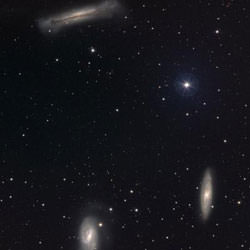
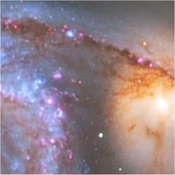
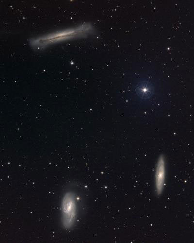
The Leo Triplet. Image credit: REU Program/NOAO/AURA/NSF. Click to enlarge
Greeting fellow SkyWatchers! This week will be a great time to go galaxy hunting and seeking out all the bright a beautiful deep space objects that signal the end of Spring and the beginning of Summer. So get out your binoculars and telescopes and get ready to rock, because…

Here’s what’s up!

Monday, May 22, 2006 – Tonight would be a great opportunity to do some binocular hunting. Starting at Regulus, see how many faint galaxies you can spot about a fist width due east. Among the brightest will be M105, M95 and M96. Another fist width east will take you just below Theta Leonis for the must easier M65 and M66.

Now return to Regulus. About a thumb’s length to the west-southwest you will spot dim R Leonis – a Mira-type variable. Discovered in 1782 by J.A. Koch, this awesome star moves from magnitude 4.4 to 11.0 magnitude is less than a year. As one of the earliest discovered, you will find it a ruby red color that goes to deep purple during its cycle. A true gem!

Tuesday, May 23 – Tonight we move on to small telescope studies as we begin at Beta Leonis (Denebola) and look about a hand span west-southwest for Epsilon Virginis (Vindemiatrix). Almost directly between them is the most heavily galaxy populated portion of the sky for a small scope!

About three finger-widths west of Epsilon, you will find M59 and M60 with M58 just a breath further west. At low power, shifting northwest one field of view will bring you to M89 and then go northeast another field for M90. Return to M89 and go less than two fields away for M87. Two fields north will bring you to M88, while one east will help you find M91.

If you get lost, don’t worry. One of the most beautiful experiences in Virgo is to simply enjoy all you can see!

Wednesday, May 24 – Be sure to check the sky this morning as brilliant Venus and the Moon have a scenic encounter.

Tonight we’ll head into larger scope territory as we explore the area around the galactic pole and star 31 Comae.

As a known member of Melotte 111, 31 Comae is an eclipsing variable star with a faint companion. Begin by centering on 31, and move south a little more than two degrees for a large, 9.2 magnitude spiral galaxy – NGC 4725. Encircled by a halo, this study contains a luminous oval nucleus. A little more than 3 degrees west-northwest will bring you to the spectacular NGC 4565. This large, slender, edge-on presentation is an easy 9.6 magnitude which shows a dark dust lane.

Now shift NGC 4565 a little more than a degree east to view the small, 9.9 magnitude elliptical galaxy – NGC 4494. Return to NGC 4565 and move two degrees north for NGC 4559. This large, 9.9 magnitude, tilted spiral will show a multi-armed structure and some patchiness to its detail. To complete the tour, four degrees east again and you’ll find yourself back at 31 Comae!

Thursday, May 25 – Has Gemini gained another twin? No. It’s just Mars south of Pollux.

Tonight, let’s try a series of challenges designed to intrigue all SkyWatchers. For visual observers, your goal is just east of Saturn. Allow your eyes plenty of time to dark adapt and seek out a large hazy patch of barely visible stars. Congratulations! You’ve just spotted M44 and seen the light – light that left the cluster in the year 1480!

For binoculars, look a fist width west of bright Spica and you’ll pick up M104. Its light came from 400 million years ago.

For the large telescope, your challenge lies five and a half degrees south of Beta Virginis and one half degree west. Classified as Arp 248, and more commonly known as “Wild’s Triplet,” these three very small interacting galaxies are a real treat! Best observed using higher magnifications, use wide aversion and try to keep the star just north of the trio at the edge of the field to cut glare.

Best of luck!

Friday, May 26 – This evening we’re going to have a look at two of the finest globular clusters for the northern hemisphere. Entering the middle third of the sky to the northeast is everyone’s favorite and champion of the overhead sky – the Great Hercules Cluster – M13. Just grazing the sky’s middle third to the south-southeast is the equally spectacular M5 in Serpens.

At magnitude 5.8, M5 is only slightly brighter cumulatively than M13 and is also just slightly larger. With good reason…It’s 600 light-years closer.

Now let’s go locate each of them. M13 is easily found just one-third the way between Eta and Zeta Herculis along the western flank of the Keystone. To locate M5, you’ll find it slightly northeast of 5 Serpens.

Which gives the better view? Well leave the decision to you!

Saturday, May 27 – Tonight is New Moon Saturday and many observers will be packing their scopes up and heading for dark skies. Many will enjoy the camaraderie of other amateurs – plus opportunities to look through different equipment and discover entirely new night sky favorites. If you’re on your own, keep this in mind: the best locations for observing will be far from city lights, at higher altitudes, and hampered by little foliage – especially to the south where studies sometimes only barely manage to clear the trees before they’re gone again. Since most star parties are held at well-selected locations, a lot of the work has already been done for you!

For observers below 40 degrees north latitude, one study will be on everyone’s list tonight – the incomparable Omega Centauri! To see it, you simply must have a clear view of the horizon to the south and begin looking for it well south of Spica as soon as it starts to get reasonably dark out. Don’t expect much of a view from the northern hemisphere. Omega may look no better than a large unresolved misty glow. But you just have to look anyway!

Even before that peek at Omega, Jupiter will dominate the sky to the south – so arrive early and set up just after sunset. Within a half hour you will see the planet culminating south. Once you’ve had that first look at Jupiter, you might want to look west toward Gemini and say goodbye to Mars and Saturn. If the seeing is really good, you will probably want to spend some quality time with Jupiter throughout the evening. One thing to watch for, the strikingly high contrast and well-defined shadow of a Galilean as it transits Jupiter’s atmosphere.

After Omega Centauri and the planets, the sky’s the limit!

Sunday, May 28 – On this day in 1959, the first primates made it to space. Abel (a rhesus monkey) and Baker (a squirrel monkey) lifted off in the nose cone of an Army Jupiter missile and were carried aloft into sub-orbital flight. Recovered unharmed, Abel died just three days later from anesthesia during an electrode removal, but Baker lived on to the ripe old age of 27.

Tonight let’s monkey around with the stars as we climb into the canopy of the heavens towards 7.7 magnitude M101!

The sprawling nature of this face-on spiral means that the light of an 8th magnitude star has to be spread very thin to cover all that celestial terrain. Its 10th magnitude core region allowed Pierre M?chain to view it on March 27, 1781. This inclusion was the last published entry in Charles Messier’s catalog. Meanwhile William Parsons (Lord Rosse), described M101 as “Large, spiral, faintish; several arms and knots. 14′ diameter at least.” – a description comparable to what is seen through the largest backyard telescopes used today.

At a distance of 27 million light-years, the true size of M101 is extraordinary – some 170,000 light-years in diameter. Its total luminosity is equivalent to over 30 billion suns. Even as large as this galaxy is, it merely approaches the size of the Milky Way!

May all your journeys be at light speed… ~Tammy Plotner with Jeff Barbour.

Three Storms on Saturn

Three big vortices swirling through Saturn’s southern latitudes. Image credit: NASA/JPL/SSI. Click to enlarge
Three giant storms swirl across the atmosphere of Saturn in this photograph taken by Cassini – the two in the upper part of the photo appear to be interacting. This image was taken by Cassini on April 15 when the spacecraft was approximately 3.9 million kilometers (2.4 million miles) from Saturn.

Three large and impressive vortices, including two that appear to be interacting, are captured here as they swirl through Saturn’s active southern latitudes.

This view shows latitudes slightly to the north of those seen in Round and Round They Go and was taken a few minutes prior to the left side image in that release.

The image was taken with the Cassini spacecraft narrow-angle camera using a spectral filter sensitive to wavelengths of infrared light centered at 750 nanometers. The image was acquired on April 15, 2006, at a distance of approximately 3.9 million kilometers (2.4 million miles) from Saturn. The image scale is 23 kilometers (14 miles) per pixel.

The Cassini-Huygens mission is a cooperative project of NASA, the European Space Agency and the Italian Space Agency. The Jet Propulsion Laboratory, a division of the California Institute of Technology in Pasadena, manages the mission for NASA’s Science Mission Directorate, Washington, D.C. The Cassini orbiter and its two onboard cameras were designed, developed and assembled at JPL. The imaging operations center is based at the Space Science Institute in Boulder, Colo.

For more information about the Cassini-Huygens mission visit http://saturn.jpl.nasa.gov . The Cassini imaging team homepage is at http://ciclops.org .

Original Source: NASA/JPL/SSI News Release

Exposed Bedrock on Mars

Cobbles appearing on trough floors between wind-blown ripples. Image credit: NASA/JPL. Click to enlarge
NASA’s Opportunity rover captured this photograph of the surface of Mars during its trek from Erebus Crater to Victoria Crater. The image shows exposed bedrock between large windblown sand ripples. Opportunity took the photo on April 27, 2006 during its 802nd Martian day of exploration.

As NASA’s Mars Exploration Rover Opportunity continues to traverse from “Erebus Crater” toward “Victoria Crater,” the rover navigates along exposures of bedrock between large, wind-blown ripples. Along the way, scientists have been studying fields of cobbles that sometimes appear on trough floors between ripples. They have also been studying the banding patterns seen in large ripples.

This view, obtained by Opportunity’s panoramic camera on the rover’s 802nd Martian day (sol) of exploration (April 27, 2006), is a mosaic spanning about 30 degrees. It shows a field of cobbles nestled among wind-driven ripples that are about 20 centimeters (8 inches) high.

The origin of cobble fields like this one is unknown. The cobbles may be a lag of coarser material left behind from one or more soil deposits whose finer particles have blown away. The cobbles may be eroded fragments of meteoritic material, secondary ejecta of Mars rock thrown here from craters elsewhere on the surface, weathering remnants of locally-derived bedrock, or a mixture of these. Scientists will use the panoramic camera’s multiple filters to study the rock types, variability and origins of the cobbles. This is an approximately true-color rendering that combines separate images taken through the panoramic camera’s 753-nanometer, 535-nanometer and 432-nanometer filters.

Original Source: NASA News Release

“Lucky” Cluster Spacecraft Buffeted by the Solar Wind

Sketch of the different regions in of Earth’s magnetosphere. Image credit: ESA. Click to enlarge
ESA’s Cluster spacecraft were in the right place at the right time when they flew through a region of the Earth’s magnetic field that accelerates electrons to approximately 1/100th the speed of light. The region is called the electron diffusion region; a boundary just a few kilometres thick between the Earth’s magnetic field and the Sun’s. Over the course of an hour, the spacecraft were engulfed in an electron diffusion region, as the solar wind was causing this layer to move back and forth.

ESA’s Cluster satellites have flown through regions of the Earth’s magnetic field that accelerate electrons to approximately one hundredth the speed of light. The observations present Cluster scientists with their first detection of these events and give them a look at the details of a universal process known as magnetic reconnection.

On 25 January 2005, the four Cluster spacecraft found themselves in the right place at the right time: a region of space known as an electron diffusion region. It is a boundary just a few kilometres thick that occurs at an altitude of approximately 60 000 kilometres above the Earth’s surface. It marks the frontier between the Earth’s magnetic field and that of the Sun. The Sun’s magnetic field is carried to the Earth by a wind of electrically charged particles, known as the solar wind.

An electron diffusion region is like an electrical switch. When it is flipped, it uses energy stored in the Sun’s and Earth’s magnetic fields to heat the electrically charged particles in its vicinity to large speeds. In this way, it initiates a process that can result in the creation of the aurora on Earth, where fast-moving charged particles collide with atmospheric atoms and make them glow.

There is also a more sinister side to the electron diffusion regions. The accelerated particles can damage satellites by colliding with them and causing electrical charges to build up. These short circuit and destroy sensitive equipment.

Nineteen times in one hour, the Cluster quartet found themselves engulfed in an electron diffusion region. This was because the solar wind was buffeting the boundary layer, causing it to move back and forth. Each crossing of the electron diffusion region lasted just 10-20 milliseconds for each spacecraft and yet a unique instrument, known as the Electron Drift Instrument (EDI), was fast enough to measure the accelerated electrons.

The observation is important because it provides the most complete measurements yet of an electron diffusion region. “Not even the best computers in the world can simulate electron diffusion regions; they just don’t have the computing power to do it,” says Forrest Mozer, University of California, Berkeley, who led the investigation of the Cluster data.

The data will provide invaluable insights into the process of magnetic reconnection. The phenomenon occurs throughout the Universe on many different scales, anywhere there are tangled magnetic fields. In these complex situations, the magnetic fields occasionally collapse into more stable configurations. This is the reconnection and releases energy through electron diffusion regions. On the Sun, magnetic reconnection drives the solar flares that occasionally release enormous amounts of energy above sunspots.

This work may also have an important bearing on solving energy needs on Earth. Nuclear physicists trying to build fusion generators attempt to create stable magnetic fields in their reactors but are plagued by reconnection events that ruin their configurations. If the process of reconnection can be understood, perhaps ways of preventing it in nuclear reactors will become clear.

However, that still lies in the future. “We need to do a lot more science before we fully understand reconnection,” says Mozer, whose aim is now to understand which solar wind conditions trigger the reconnection events and their associated electron diffusion regions seen by Cluster.

Original Source: ESA Portal