Looking Down the Barrel of A Gamma Ray Burst

movie_11.thumbnail.gif

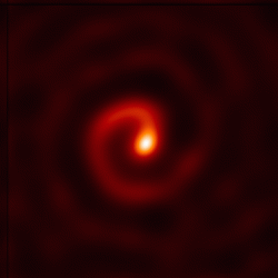
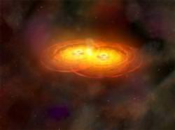
A team of astronomers from the University of Sydney in Australia have been keeping an eye on a binary star system called Wolf-Rayet 104, located in the constellation Sagittarius. Wolf-Rayet stars are hot, gargantuan, older stars that are losing their masses, and astronomers consider these stars as ticking bombs: they could go supernova at any time within the next few hundred thousand years. That’s a relatively short fuse for astronomers. Images of this system from the Keck Telescope show an almost perfect spiral nebula formed by the two stars orbiting each other as they each blow off streams of gas. The way this system is spinning caught the eyes of these astronomers, who say Earth could be in the line of fire when the system blows.

Usually, a supernova explosion would be harmless at interstellar distances like the 8000 lightyears that this system lays from Earth, and it would just provide an impressive show for stargazers. But astronomers say the only way WR 104 could appear as an almost perfect spiral is if those of us on Earth were looking down the spin-axis of the system. Astronomer Peter Tuthill says that sometimes, supernovae focus their energy into a narrow beam of very destructive gamma-ray radiation along the axis of the system. A gamma-ray burst is a super-duper supernova that sometimes happens to massive stars, like the ones in WR 104.

As of now, no one can say for sure when the system will go supernova, or how massive and powerful the explosion might be. But the way these two stars are spinning about each other has astronomers thinking this system won’t provide just a run-of-the-mill explosion.

And an intensive gamma-ray burst at that distance could possibly be harmful to life on Earth.

But right now, this is all speculation, and more study on this system is needed before anyone needs to get worried. And this is all definitely very fascinating.

11 image stack.  Image Credit:  University of Sydney
“I used to appreciate this spiral just for its beautiful form, but now I can’t help a twinge of feeling that it is uncannily like looking down a rifle barrel,” says Dr. Peter Tuthill.

With a sequence of 11 different images, the astronomers were able to portray how the spiral nebula of this system is rotating in a circle every 8 months.

Original News Source: University of Sydney Press Release

HiRISE Captures Stunning Images of Mars Avalanches in Action

A Mars Avalanche, taken by NASAs HiRISE instrument on the Mars Reconnaisance Orbiter (Credit: NASA/HiRISE)

Magnificent images of avalanches of ice and rock in the northern polar regions of Mars have been captured by NASA Mars Reconnaissance Orbiter’s (MRO) High Resolution Imaging Science Experiment (HiRISE). These images are not of landslides that have happened in the past, they are actual Mars avalanches happening at the moment of observation. This rare event will be of tremendous value to Mars scientists currently analysing the effects of seasons on the landscape and will provide information on the geological activity of the planet…

This event occurred along a scarp (a distinct cliff, with a steep runoff) around the North Polar Region where surface ice can be found in large quantities. The HiRISE instrument was being used to assess seasonal changes around the North Pole when four areas of activity were seen along the scarp. HiRISE was witness to something more familiar on Earth than on Mars: avalanches.

This particular scarp is a high cliff over 700 m (2300 ft) tall and slopes at over 60 degrees. A mixture of ice, rock and dust can be seen, frozen in time, as it is plummeting down the slope, ejecting a plume of dust as the debris begins to settle on the gentle slope at the bottom of the cliff. The ejected cloud is approximately 180 meters across and extends about 190 meters beyond the base of the cliff. It is worth noting that the clouds are large 3D structures reaching into the Martian atmosphere and not 2D patterns on the surface (shadows from the plume can be seen to the lower left of the clouds of dust).

Mars polar region including scarp where avalanches were discovered - approximate locations of avalanches ringed (credit: NASA/JPL/UA)

The Martian landscape does not change very much over millions of years. Unlike the Earth, Mars does not have a thick, eroding atmosphere blasting away at the surface features. The lack of water also reduces these erosion effects. Mars also has very little geological activity as core reactions are thought to have slowed or even stopped – there is therefore very little tectonic movement, no major earthquakes and no evidence for present volcanic activity.

So what caused these avalanches? HiRISE scientists have some ideas:

  • Disappearance of carbon dioxide frost, dislodging rocks.
  • Expansion and contraction of ice due to seasonal temperature differences.
  • Small Mars-quakes.
  • A nearby meteorite impact.
  • Vibrations from other avalanches causing other avalanches along the scarp

Detail of the avalanches occurring along the scarp (credit: NASA/JPL/UA)

It seems most likely that the trigger may be down to seasonal changes. As the North Polar Region heats up (progressing toward summer), solid carbon dioxide (“dry ice”) may be subliming, weakening rocks around the edge of the cliff. The same could be said for the thermal expansion and contraction of water ice as the seasonal air temperature becomes warmer or cooler.

Whatever the cause, we are very lucky to have captured this event, the science collected from these observations will be critical to understanding how the Martian landscape can change very rapidly. The HiRISE instrument continues to return the most magnificently detailed images of the Red Planets surface, these observations of Mars avalanches will certainly go into the Mars Reconnaissance Orbiter’s Hall of Fame…

Source: HiRISE Project Site

Tracking Debris from US Spy Satellite USA 193; Delays to Rocket Launch

orbits.thumbnail.gif

The shoot down of US spy satellite USA 193 was condemned by some quarters of the international community. However, the fact remains, this was a resounding success for the US military. Observers of the operation to destroy the potentially dangerous satellite likened it to “trying to fire a missile through the eye of a needle”. After all, the dead satellite was orbiting at a height of about 250 km, and the satellite-killing missile was fired from a boat; assuring impact with an object the size of a small bus was never going to be easy. But the mission was a success and the satellite disintegrated into bits (no bigger than a football). Now the task of tracking the debris is under way, and the fallout from last months fireworks are impacting the scheduled launch of other space missions…

According to CelesTrak, there are 52 catalogued bits of USA 193 orbiting the Earth. The pieces range in altitude from 167 km (at the closest approach) to over 2,600 km (at apogee – the highest point of orbit) and they are being tracked with great accuracy (pictured above).
Plot showing the projected lifetime of the USA 193 space debris (credit: CelesTrak)
The 5,000 pound (2,300 kg) satellite apparently disintegrated into many small pieces of debris, each no bigger than the volume of a football (equivalent to a circle with a diameter of 20 cm). Anything smaller than 10 cm cannot be tracked with any degree of accuracy, so an analysis by CelesTrak (pictured left) shows the upper and lower bounds of debris that can be tracked and how long they are likely to stay in orbit.

As a rule, larger pieces of debris will remain in orbit for longer, whilst the smaller objects will have less momentum to stay above the Earths atmosphere. As can be seen, most of the debris can be expected to burn up through atmospheric re-entry within 30 days, but there is a massive difference in the lifetime of the remaining 10 cm debris when compared with the 20 cm debris. The remaining 5% of large chunks of satellite are projected to stay in orbit for 50 days longer than their smaller cousins.

Tracking these bits of debris is an arduous task, but the monitoring continues. The destruction of USA 193 has influenced the scheduled launch of rockets since February 20th, and disruption is likely to continue should these larger pieces of debris pass through spacecraft launch windows. The launch of a US National Reconnaissance Office NROL-28 reconnaissance satellite last Friday from Vandenberg Air Force Base in California, has been postponed for two weeks until the USA 193 debris poses no threat of collision.

Universe Today coverage of the demise of satellite USA 193:

Original Source: CelesTrak

Latest Mars Images Round-up

With three orbiters and two rovers currently at Mars, there are always interesting images coming back from the Red Planet. Here’s a round-up of the latest images from the five different spacecraft. First up is a fascinating image from the Mars Odyssey spacecraft of dust devil tracks. It’s amazing just how many tracks there are in just this one image. Martian dust devils can be up to fifty times as wide and ten times as high as dust devils seen on Earth. This image was taken by Odyssey’s Thermal Emission Imaging System (THEMIS), and shows an area in the south polar region, just east of Daly Crater. Resolution is about 17 meters per pixel. Original Image link.


NASA’s Mars Exploration Rover Spirit has this view northward from the position at the north edge of the “Home Plate” plateau where the rover will spend its third Martian winter. And no, that’s not a pool of water in the image. It’s just rippled sand in the “El Dorado” sand dune field, and the image is shown in false color.

Husband Hill is on the horizon. Spirit used its panoramic camera (Pancam) to capture this image during the rover’s 1,448th Martian day, on January 29, 2008.
Original image link.

This view from the Opportunity rover shows a close-up of bedrock from the inside of Victoria Crater, where the rover is currently studying a stratigraphic layer of rocks. This area is informally named “Lyell,” which is the lowermost of three layers the rover has examined at a bright band around the inside of the Crater.

Opportunity used its panoramic camera (Pancam) to capture this image with low-sun angle at a local solar time of 3:21 p.m. during the rover’s 1,433rd Martian day, on February 4, 2008. This image, too, is in false color to highlight the ripples and bands in the bedrock.
Original Image link.

Mars Express Candor Chasma.  Image Credits: ESA/ DLR/ FU Berlin (G. Neukum)
ESA’s Mars Express took snapshots of Candor Chasma, a valley in the northern part of Mar’s huge canyon, Valles Marineris, as it was in orbit above the region on 6 July 2006.

The High Resolution Stereo Camera on the orbiter obtained the data,with a ground resolution of approximately 20 m/pixel. Candor Chasma lies at approximately 6° south and 290° east.
Original Image link.

HiRISE Volcanic Vent.  Credit: NASA/JPL/University of Arizona

This image taken by the Mars Reconnaissance Orbiter (MRO) shows a volcanic vent. A volcanic vent is an opening in the crust of a planet that emits lava (molten rock) and volcanic gases. The rough texture of the plains surrounding the vent iindicates that it is lava.

There is a large number of snake-like features emanating from the vent. The parallel lines that outline the features are levees, which mark the edges of channels that carried molten lava. As lava flows, it moves slowest at its edges and bottom because the lava sticks to the non-flowing rocks, and as the lava slows, it cools off and hardens.

Levees form when the sides harden but the center of the flow keeps moving. As the eruption episode ends, and the lava drains, the center is left lower than the sides producing these high-standing structures. Of course, these lava flows are very, very old.
Original Image page.

UK Urged to Focus on Satellite Technology, not Manned Exploration of Space

41346372_sellers_nasa_203.thumbnail.jpg

The UK is the only G8 country (the eight richest countries in the world) without a manned space program. 20 years ago, Prime Minister Margaret Thatcher put pay to any hope for a British astronaut by opting out of plans citing it as “too expensive” for the island nation. However, the UK government signalled last month they were considering a review of this space exploration policy, receiving a mixed reaction. A prominent satellite manufacturer has come forward with a suggestion that the UK may after all be better suited to constructing a space exploration “infrastructure” and leaving manned exploration to the ESA and NASA…


In 1986, the UK was effectively ruled out of manned expeditions into space. Plans outlined by the European Space Agency (ESA) at the time were considered too expensive for the nation to pursue, so the UK concentrated on its civil and defence space capabilities through robotic explorers rather than participating in any national or international collaboration.

As of 2007, after two decades of research and development, Britain spends over £200 million ($400 million) a year on space initiatives, putting some of the world’s most advanced technology into space. UK companies such as SSTL, Qinetiq, Logica and Astrium are leading the world in certain space technology areas as a result. Many in the industry (especially the satellite manufacturing sector) would agree that the lack on participation in a manned space program has provided growth in robotic exploration sectors.

This may be the case, but there is pressure for the UK to catch up with the other seven nations of the G8 and begin sending British astronauts into space rather than depending on NASA and the ESA. British-born astronauts have been into space, such as Piers Sellers (pictured above), Michael Foale (dual nationality – Britain and USA) and Nicholas Patrick; Helen Sharman was the first Briton in space in 1991. All British astronauts were either naturalized American or involved with other space programs, little investment was made by the UK government in any manned mission.
An artists impression of the Habitation Extension Module - a concept by British designers for the ISS (credit: SimComm/Ducros)
Many academics would disagree with the UK’s past unwillingness to “get involved” in a manned program. As the worlds nations become more and more space-worthy, many believe the UK is being left behind and the dependence on NASA and ESA will become problematic as time goes on. There would be economic and educational value in starting a UK manned space program too. Looking back on the stimulation that the Apollo program had on the US in the 1960’s, the nation saw a surge of interest in the sciences and engineering subjects. This educated an entire generation of college and university students who have formed the foundations of the hugely influential space program that exists today.

The UK needs to take early steps for a future role in a human exploration programme. It can stimulate education and excite the young to get involved in science and technology.” – Professor Frank Close, Oxford University and Chairman of the UK Space Exploration Working Group (in an interview with The Independent Online).

But the idea of a UK manned space program may push the nation beyond its means according to David Williams, head of Avanti, a satellite communications company. Williams believes that the UK, after many years of space innovation and robotic exploration of space and the planets, is ideally placed to dominate the world’s communication ability with deep space missions.

If mankind is going to exploit the resources of the solar system, you are going to have to travel over very long distances and you are going to have to communicate over very long distances and you will need a network of data-relay satellites. The UK has a big advantage. We have the opportunity to control the space internet, which is going to be this network of data-relay satellites.” – David Williams.

Following this logic, as space exploration is an international effort, letting big space agencies such as ones controlled by the USA, Russia and Europe pursue manned exploration, the UK has an important role to play to insure advanced communication technology keep the international manned space efforts in touch with Earth.

Either way, this is an exciting time for UK space efforts. Although recently buffeted by funding shortages, there appears to be some positive movement toward greater involvement in international collaboration and investment in satellite technologies.

Source: The Guardian Online, The Independent Online

Mars Gullies Produced by Dry Granular Debris and Not by Recent Water Flow

The High Resolution Imaging Science Experiment (HiRISE) on board NASA’s Mars Reconnaissance Orbiter (MRO) observed what appeared to be fresh gullies formed by a rapid release of water on the Martian surface in 2006. However, new computer models simulating the creation of gullies on the surface of Mars suggest that they are in fact created by the flow of dry debris (i.e. landslides) and not by the flow of water. A blow for the microbial life hunters and a huge blow for mission planners looking for easy sources of water for manned missions…

The MRO isn’t the only orbiter to view apparent gullies forged by spurts of water. The Mars Orbiter Camera (MOC) onboard NASA’s Mars Global Surveyor (MGS) also made news in 2006 when scanning the cratered regions of Terra Sirenum and Centauri Montes. Images taken several years apart revealed some changes in the most recent pictures, highlighting what looked like outflow channels from surges of liquid water (pictured below). What made this especially exciting was that this was possible evidence for the existence of liquid water flowing on Mars within the past few years (albeit very quickly).
Before and after pictures by MOC of a gully inside a crater (credit: NASA/JPL)
New work by scientists at the University of Arizona appears to conflict with these observations. In an attempt to demonstrate the characteristics of water flowing in Martian conditions, Associate Professor Jon D. Pelletier (Geophysics) and colleagues used topological data from the HiRISE instrument (the most advanced imaging system currently orbiting Mars) and modelled the flow of water down a slope. What the simulation showed was a surprise; the researchers went into the project thinking they were going to prove that the gullies were formed by water. Instead, they had shown that the shapes and characteristics of the observed gullies most resembled that of the modelled gullies shaped by dry debris tumbling down a slope.

The dry granular case was the winner. I was surprised. I started off thinking we were going to prove it’s liquid water.” – Jon D. Pelletier

Looking at the comparison between the two cases (water and dry debris flow) and the HiRISE observations, it is very easy to see the striking resemblance between dry debris flow and what is actually observed. The water simulation appears to be more diffuse, lacking the characteristic “fingers” reaching down the slope.

On hearing the news in 2006 that there was a possibility of liquid water flowing on the Martian surface, biologists hoped that a new tool had been found to pinpoint where sub-surface deposits of liquid water may be stored. This will have provided future missions with a location to hunt for life in the most likely place, near fresh gullies, near a source of water. Unfortunately it seems that these gullies are in fact shaped by small landslides, not by surges of water from a sub-surface reservoir.

Research to be published in the March issue of Geology, entitled: “Recent bright gully deposits on Mars: wet or dry flow?“.

Source: University of Arizona News

First Experiment Starts in ISS Columbus Module Testing Plant Growth

01_arabidopsis_large0.thumbnail.jpg

The brand new ESA Columbus Module installed on the International Space Station (ISS) by the STS-122 crew last week is beginning a first run of biological experiments. This first experiment tests the reaction of root growth in different gravitational states. Of particular interest is how the roots of seeds develop in space when compared to terrestrial conditions. This has obvious applications for growing plants in space, underpinning agricultural science in some of the most extreme and challenging environments man will experience.

Today saw the first ever experiment on the ESA Columbus Module on board the ISS. European astronaut Léopold Eyharts activated the Waving and Coiling of Arabidopsis Roots at Different g-levels (WAICO) experiment, comparing two types of arabidopsis seed (one wild and one genetically modified) in gravity conditions from zero to one Earth gravity (or 1G). The arabidopsis seed is derived from the arabidopsis thaliana plant which copes very well in restricted space and thrives in hostile surroundings.
The Columbus module Biolab where biological experiments will be carried out on the ISS (credit: ESA)
The WAICO experiment will last for 10 to 15 days and the sprouted seeds will be returned by the STS-123 Space Shuttle mission due for launch on March 11th so the results can be analysed. Throughout the experiment, using the brand new “Biolab” equipment (pictured), the advanced telemetry of the Columbus Module will relay real-time video of seed development to ESA scientists in Germany.

The development of the root growth will be scrutinized; especially the amount of “waving” and “coiling” that occurs as a reaction to different gravity conditions. These experiments will also help terrestrial farming methods, giving farmers the opportunity to optimize plant growing conditions.

Source: ESA

Shuttle Endeavour to Launch on March 11th; View the STS-123 Interactive Mission Timeline

We haven’t had time to catch our breath after STS-122 touched down on February 20th, only nine days ago, and yet the next launch date to the International Space Station (ISS) has been announced today. The date? March 11th - only 11 days from now. This time NASA has put together a nice little interactive gadget so you can see the 17 day mission from day to day…

STS-122 was a highly successful round trip to the ISS. The Space Shuttle Atlantis crew delivered ESA’s Columbus science module without a hitch on February 11th. The only small problem arose when one of the crew members suffered an undisclosed minor medical problem, postponing installation for a day, but the crew adapted and performed excellently.
Space Shuttle Endeavour waiting on the launchpad (credit: NASA)
With Atlantis’ engines still warm, Endeavour is being prepared for launch on March 11th. This time the mission is to install a part of the Japanese laboratory complex called “Kibo”. In addition, a new Canadian robotics system will be attached to complement the existing robotic arm servicing the Harmony module.

STS-123 will be a complex mission for crew members Dominic Gorie (Commander), Gregory H. Johnson (Pilot), Rick Linnehan (Mission Specialist), Robert L. Behnken (Mission Specialist), Mike Foreman (Mission Specialist), Garret Reisman (Mission Specialist) and Japanese astronaut Takao Doi. Five spacewalks (EVAs) will need to be carried out to continue the expansion of the station.

The Associate Administrator for Space Operations, Bill Gerstenmaier, stated that there were very few issues with the pre-launch stages and said that Space Shuttle Endeavour is ready to blast off.

View the interactive guide of the STS-123 mission to the ISS.

Source: NASA

Final Detector in Place at the Large Hadron Collider

smallwheel1.thumbnail.jpg

One of the most complicated construction projects ever attempted reached a major milestone today. The final large detector element for the ATLAS instrument was lowered into the Large Hadron Collider. And this baby’s big. Weighing in at 100 tonnes. When the collider finally comes online, this instrument will measure the cascade of particles generated in proton-proton collisions.

The ATLAS detector itself is enormous, weighing 7,000 tonnes and measuring 46 metres long, 25 metres high and 25 metres wide. It has 100 million sensors that will track all the particles that freeze out when protons are smashed together at tremendous energies.

And so today, the final element for ATLAS was plugged into its permanent home. It’s known as a “small wheel”, and there are two of them in the detector. Compared to the full ATLAS instrument, it only weighs 100 tonnes, and measures a mere 9.3 metres across.

Since the whole detector is located deep underground, engineers had to lower each piece down a 100 metre shaft. And they’ve been installing pieces this way since 2003. In the case of the small wheel, it was even harder to get it down.

“One of the major challenges is lowering the small wheel in a slow motion zigzag down the shaft,” explained Ariella Cattai, leader of the small wheel team, “and performing precision alignment of the detector within a millimetre of the other detectors already in the cavern.”

With all of ATLAS’ parts in place, it’s time to enter the commissioning phase. Researchers will test all of the parts together in preparation for the first tests this Summer.

By this time next year, physicists might have many more answers about the nature of gravity, dark matter, and nature’s preference for matter over dark matter. And I’m sure they’ll have even more new questions. But that’s how science works.

Original Source: CERN News Release

What Happens When Supermassive Black Holes Collide?

070517_bholemerger_hmed_11ah2.thumbnail.jpg

As galaxies merge together, you might be wondering what happens with the supermassive black holes that lurk at their centres. Just imagine the forces unleashed as two black holes with hundreds of millions of times the mass of the Sun come together. The answer will surprise you. Fortunately, it’s an event that we should be able to detect from here on Earth, if we know what we’re looking for.

Most, if not all, galaxies in the Universe seem to contain supermassive blackholes. Some of the biggest can contain hundreds of millions, or even billions of times the mass of our own Sun. And the environments around them can only be called “extreme”. Researchers think that many could be spinning at the maximum rates predicted by Einstein’s theories of relativity – a significant fraction of the speed of light.

As two galaxies merge, their supermassive black holes have to eventually interact. Either through a direct collision, or by spiraling inward until they eventually merge as well.

And that’s when things get interesting.

According to simulations made by G.A. Shields from the University of Texas, Austin, and E.W. Bonning, from Yale University, the result is often a powerful recoil. Instead of coming together nicely, the forces are so extreme that one black holes is kicked away at a tremendous velocity.

The maximum kick happens with the two black holes are spinning in opposite directions, but they’re on the same orbital plane – imagine two spinning tops coming together. In a fraction of a second, one black hole is given enough of a kick to send it right out of the newly merged galaxy, never to return.

As one black hole is given a kick, the other receives a tremendous amount of energy, injected into the disk of gas and dust surrounding it. The accretion disk will blaze with a soft X-ray flare that should last thousands of years.

So even though mergers between supermassive black holes are extremely rare events, the afterglow lasts long enough that we should be able to detect a large number out there in space right now. The researchers estimate that there could be as many as 100 of these recent recoil events happening within 5 billion light-years of the Earth.

Their recently updated journal article, entitled Powerful Flares from Recoiling Black Holes in Quasars will be published in an upcoming issue of the Astrophysics Journal.

Original Source: Arxiv