[/caption]
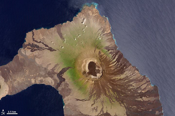
Some of the most dramatic mountains in the world are volcanoes. Volcanoes can grow to enormous heights quickly, sometimes just a few years. But have you ever wondered, how are volcanoes formed?
As you probably know, you’re standing on the Earth’s crust; a relatively thin layer of solid Earth. Beneath this is the mantle, an extremely hot region just a few dozen kilometers beneath your feet. Although the mantle is almost entirely solid, it can form small pockets of liquid rock and hot gasses. It’s hard to think of this way, but the molten rock – called magma – is more buoyant than the surrounding solid rock. It slowly forces its way upward through weaknesses in the Earth’s crust. These become volcanoes.
When the magma reaches the surface, it wells out onto the surface forming a volcano. What kind of volcano forms depends on the size of the crack in the crust, and the kind of lava that comes out. Some lava is very fluid, and can flow for long distances. This kind of lava creates shield volcanoes, like in the Hawaiian islands. Other lava is very thick, and doesn’t travel very far, creating the more familiar cinder cone shaped volcanoes.
Some very energetic volcanoes will spew rock, ash and magma high into the air. This material falls back down around the vent, and this is how the volcano builds up. The volcano is like a big debris pile surrounding the volcanic vent.
The largest, most dramatic volcanoes in the world are composite volcanoes, or stratovolcanoes. These can have vast networks of volcanic vents and chambers, with many openings to the surface. They can be made up of lava flows and deposits of ash that build up into huge mountains over millions of years. Some of the most dramatic mountains in the world are composite volcanoes: Mt. Fuji, Mt Kilimanjaro, and Mt. Rainier, for example.
Obama and friends chat with ISS astronauts. Image Credit: White House/Pete Souza
[/caption]
The ten astronauts aboard the International Space Station chatted with US President Barack Obama – along with some school children and Congressmen (“big kids when it comes to talking to astronauts,” Obama said). Topics discussed during the 30 minute conversation included the new solar arrays installed by the STS-119 crew, extraterrestrial life, video games, space food and exercise. Obama got a big laugh in orbit and on the ground when said he was glad the astronauts were using a hands-free phone since they were cruising along at 17,500 mph. He also asked if the astronauts still drank Tang, which didn’t even merit a reply from space.
The president told the ISS crews and the visiting shuttle crew he was extraordinarily proud of them for their work the past week, and wanted details of how they installed the new solar panels.
“We’re investing back here on the ground a whole array of solar and other renewable energy projects and so to find out that you’re doing this up at the space station is particularly exciting,” Obama said.
Last week’s addition of the last set of solar wings doubled the amount of power available for science experiments and will help support a larger crew in a few months.
Obama also asked Sandy Magnus, who has been on board the ISS for several months, and the only woman on board, whether she was ever tempted to cut her hair, which floated around her head. She said no, and the president called it “a real fashion statement.”
Obama also noted the “international-ness” of the ISS and said, “One of the things about this that this is an international space station, and we hope this is an example of the sort of spirit of cooperation we can apply not just in space by here on the ground as well.”
If you didn’t get a chance to watch the IYA telescope “live” on Galactic TV today, don’t worry. We took a video capture for you. Step inside to enjoy today’s view of NGC 4755…
The Jewel Box (also known as NGC 4755 or Kappa Crucis Cluster) is an open cluster in the constellation of Crux. As Kappa Crucis, it has a Bayer designation despite the fact that it is a cluster rather than an individual star.
It is one of the finest open clusters discovered by Nicolas Louis de Lacaille when he was in South Africa during 17511752. This cluster is one of the youngest known, with an estimated age of only 7.1 million years. It has an apparent magnitude of 4.2, and is located 6,440 light years from Earth and contains around 100 stars. This famous group of young bright stars was named the Jewel Box from its description by Sir John Herschel as “a casket of variously coloured precious stones,” which refers to its appearance in the telescope. The bright orange star Kappa Crucis contrasts strongly against its predominantly blue, hot companions. Kappa Crucis is a very large (hence very luminous) young star in its red supergiant stage, which paradoxically indicates that its life is drawing to a close. The cluster looks like a star to the unaided eye and appears close to the easternmost star of the Southern Cross, (Beta Crucis), so is only visible from southern latitudes. (Information courtesy of Wikipedia)
Right now the IYA remote live telescope is a work in progress. Be aware that video recordings will be jerky until we get some of the system bugs worked out. As always, you can visit the remote telescope by clicking on the IYA “LIVE Remote Cam” Logo to your right. We’ll be broadcasting whenever skies are clear and dark in Central Victoria! Enjoy….
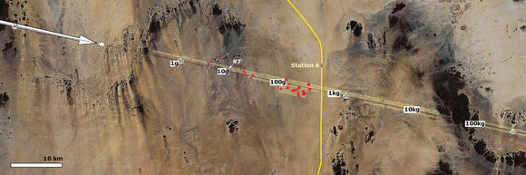
Map of the Nubian Desert of northern Sudan with the groundprojected approach path of the asteroid 2008 TC3 and the location of the recovered meteorites. Credit: P. Jenniskens, et. al
[/caption]
Remember in October 2008 when Asteroid 2008 TC3 hit the scene – literally? This was the first asteroid that was predicted –and predicted correctly — to impact the Earth. Luckily, it wasn’t big enough to cause any problems, and its path was over a remote area in Africa. It streaked into the skies over northern Sudan in the early morning of October 7, 2008, and then exploded at a high 37 km above the Nubian Desert, before the atmosphere could slow it down. It was believed that the asteroid likely had completely disintegrated into dust. But meteor astronomer Peter Jenniskens thought there might be a chance to recover some of the remains of this truck-sized asteroid. And he was right.
Never before have meteorites been collected from such a high altitude explosion. Additionally, as it turns out, the assembled remnants are unlike anything in our meteorite collections, and may be an important clue in unraveling the early history of the solar system.
A meteor astronomer with the SETI Institute’s Carl Sagan Center, Jenniskens established a collaboration with Mauwia Shaddad of the Physics Department and Faculty of Sciences of the University of Khartoum. The two traveled to the Sudan. Various meteorites from 2008 TC3. Credit: P. Jenniskens, et. al. Click image for full description
Fifteen fresh-looking meteorites with a total mass of 563 g were recovered by 45 students and staff of the University of Khartoum during a field campaign on December 5-8, 2008. A second search on December 25-30 with 72 participants raised the total to 47 meteorites and 3.95 kg. Masses range from 1.5 g to 283 g, spread for 29km along the approach path in a manner expected for debris from 2008 TC3
“This was an extraordinary opportunity, for the first time, to bring into the lab actual pieces of an asteroid we had seen in space,” said Jenniskens, the lead author on a cover story article in the journal Nature that describes the recovery and analysis of 2008 TC3.
Click here for several images from NASA about the asteroid hit and the recovery of the meteorites.
Picked up by Arizona’s Catalina Sky Survey telescope on 6 October, 2008, Asteroid 2008 TC3 abruptly ended its 4.5 billion year solar-system odyssey only 20 hours after discovery, when it broke apart in the African skies. The incoming asteroid was tracked by several groups of astronomers, including a team at the La Palma Observatory in the Canary Islands that was able to measure sunlight reflected by the object.
Studying the reflected sunlight gives clues to the minerals at the surface of these objects. Astronomers group the asteroids into classes, and attempt to assign meteorite types to each class. But their ability to do this is often frustrated by layers of dust on the asteroid surfaces that scatter light in unpredictable ways.
Jenniskens teamed with planetary spectroscopist Janice Bishop of the SETI Institute to measure the reflection properties of the meteorite, and discovered that both the asteroid and its meteoritic remains reflected light in much the same way — similar to the known behavior of so-called F-class asteroids.
“F-class asteroids were long a mystery,” Bishop notes. “Astronomers have measured their unique spectral properties with telescopes, but prior to 2008 TC3 there was no corresponding meteorite class, no rocks we could look at in the lab.” Petrography of Almahata Sitta. Credit: Jenniskens, et. al. Click for full description
The good correspondence between telescopic and laboratory measurements for 2008 TC3 suggests that small asteroids don’t have the troublesome dust layers, and may therefore be more suitable objects for establishing the link between asteroid type and meteorite properties. That would allow us to characterize asteroids from afar.
Rocco Mancinelli, a microbial ecologist at the SETI Institute’s Carl Sagan Center, and a member of the research team, says that “2008 TC3 could serve as a Rosetta Stone, providing us with essential clues to the processes that built Earth and its planetary siblings.”
In the dim past, as the solar system was taking shape, small dust particles stuck together to form larger bodies, a process of accumulation that eventually produced the asteroids. Some of these bodies collided so violently that they melted throughout.
2008 TC3 turns out to be an intermediate case, having been only partially melted. The resulting material produced what’s called a polymict ureilite meteorite. The meteorites from 2008 TC3, now called “Almahata Sitta,” are anomalous ureilites: very dark, porous, and rich in highly cooked carbon. This new material may serve to rule out many theories about the origin of ureilites.
In addition, knowing the nature of F-class asteroids could conceivably pay off in protecting Earth from dangerous impactors. The explosion of 2008 TC3 at high altitude indicates that it was of highly fragile construction. Its estimated mass was about 80 tons, of which only some 5 kg has been recovered on the ground. If at some future time we discover an F-class asteroid that’s, say, several kilometers in size — one that could wipe out entire species — then we’ll know its composition and can devise appropriate strategies to ward it off.
As efforts such as the Pan-STARRS project uncover smaller near-Earth asteroids, Jenniskens expects more incidents similar to 2008 TC3. “I look forward to getting a call from the next person to spot one of these,” he says. “I would love to travel to the impact area in time to see the fireball in the sky, study its breakup and recover the pieces. If it’s big enough, we may well find other fragile materials not yet in our meteorite collections.”
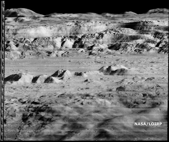
Restored image of Copernicus Crater. Credit: NASA/LOIRP
[/caption]
More imaging goodness is now available from the folks at the Lunar Orbiter Image Recovery Project (LOIRP), a cooperative effort between NASA and private business to give new life to some of the first ever close-up images of the Moon. When this image was originally released in November of 1966, it was called the “Image of the Century.” Taken by the Lunar Orbiter 2 spacecraft, 45.7 kilometers (28.4 miles) above the Moon’s surface, the image showed details of the interior of the crater Copernicus. Now, through the work of (LOIRP), the image has been remastered to show even more detail and the dramatic landscape within the crater.
At the time this image was originally released most views of the lunar surface involved looking straight down. Little, if any, sense of the true elevation of lunar surface features was usually available. This photo changed that perception by showing the Moon to be a world with tremendous topography – some of it Earth-like, much of it decidedly un-earth-like.
Time Magazine wrote about the image in December of 1966, (“A New Look at Copernicus”): “Except for the black sky in the background, the photograph might have been mistaken for a composite of the scenic grandeur of Grand Canyon and the barren desolation of the Badlands of South Dakota. But when it was flashed unexpectedly onto a screen at a meeting of the American Institute of Aeronautics and Astronautics in Boston last week, sophisticated space scientists and engineers recognized the terrain immediately. It was a spectacular close up shot of lunar landscape. That photograph of the moon’s Crater of Copernicus, said NASA Scientist Martin Swetnick, is “one of the great pictures of the century.”
NASA and a few private space business leaders spent a quarter million dollars rescuing the historic photos from early NASA lunar robotic probes and restoring them in an abandoned McDonald’s at Moffet Field, in California. This project uses the original analog data tapes and restored tape drives to digitize original Lunar Orbiter project imagery. Utilizing computer technology unavailable at the time the images were originally taken, LOIRP has been able to produce images which greatly exceed the resolution of the images as they were first seen in 1966 and 1967.
The first image released by the LOIRP, the famous “earthrise image”, was made public in November 2008, and they hope to be releasing more “new” images soon.
The LOIRP, funded by NASA’s Exploration Mission Systems Directorate and NASA’s Innovative Partnership’s Program, with support from Odyssey Moon, Skycorp Inc., SpaceRef Interactive Inc., ACES, and the NASA Lunar Science Institute.
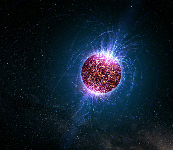
Einstein@Home is one of the world’s largest public computing projects, with more than 200,000 people donating time on their own computers to mine gravitational wave data for the tell-tale signs of pulsars.
Now, Einstein@Home will begin searching Arecibo radio data to find binary systems consisting of the most extreme objects in the universe: a spinning neutron star orbiting another neutron star or a black hole.
And the project needs even more public participation.
Today, Bruce Allen, director of the Einstein@Home project, and Jim Cordes, of Cornell University, announced that the Einstein@Home project is beginning to analyze data taken by the PALFA Consortium at the Arecibo Observatory in Puerto Rico. PALFA is the Pulsar Arecibo L-band Feed Array Consortium, an ongoing search effort.
The Arecibo Observatory is the largest single-aperture radio telescope on the planet and is used for studies of pulsars, galaxies, solar system objects, and the Earth’s atmosphere.
Current searches of radio data lose sensitivity for orbital periods shorter than about 50 minutes. But the enormous computational capabilities of the Einstein@Home project (equivalent to tens of thousands of computers) make it possible to detect pulsars in binary systems with orbital periods as short as 11 minutes. The project is based at the University of Wisconsin in Milwaukee and the Albert Einstein Institute in Germany.
“Discovery of a pulsar orbiting a neutron star or black hole, with a sub-hour orbital period, would provide tremendous opportunities to test General Relativity and to estimate how often such binaries merge,” said Cordes.
The mergers of such systems are among the rarest and most spectacular events in the universe. They emit bursts of gravitational waves that current detectors might be able to detect, and they are also thought to emit bursts of gamma rays just before the merged stars collapse to form a black hole.
“While our long-term goal is to detect gravitational waves, in the shorter term we hope to discover at least a few new radio pulsars per year, which should be a lot of fun for Einstein@Home participants and should also be very interesting for astronomers,” Allen added. “We expect that most of the project’s participants will be eager to do both types of searches.”
Einstein@Home participants will automatically receive work for both the radio and gravitational-wave searches.
The large data sets from the Arecibo survey are archived and processed initially at Cornell and other PALFA institutions. For the Einstein@Home project, data are sent to the Albert Einstein Institute in Hannover via high-bandwidth Internet links, pre-processed and then distributed to computers around the world. The results are returned to AEI, Cornell, and UWM for further investigation.
This video is incredible, almost like something from a sci-fi movie – and the sound is unbelievable! But this is the real deal. NASA mounts cameras on the Solid Rocket Boosters (SRBs), enabling those of us who are Earth-bound to ride along (and for NASA engineers to have a first-hand look at what is going on, too – the real reason for these cameras). In the first part of the video, you see the SRB separation and the shuttle pulling away, which is just magnificent! Plus, you ride along the whole way back to Earth until the parachutes deploy on the SRBs and you splash down in the ocean. The second part, you ride the along for the launch. You get a bird’s eye view (or is that a BAT’s eye view?!) of when the water suppression system starts, the SRBs light, the main engines start, and then you’re hauling the mail. Its great fun and way, way cool:
Cassini's radar mapper has obtained stereo views of close to 2 percent of Titan's surface during 19 flybys over the last five years. Image credit: NASA/JPL/USGS
[/caption]
Hang on, and enjoy a virtual flyover of Saturn’s moon Titan! Data from Cassini’s radar instrument have been used to create new flyover maps of Saturn’s largest moon. The maps show the topography of Titan in 3-D, and illustrating the height of the 1,200-meter (4,000-foot) mountain tops, the north polar lake country, the vast dunes more than 100 meters (300 feet) high that crisscross the moon, and the thick flows that may have oozed from possible ice volcanoes. “These flyovers let you take in the bird’s-eye sweeping views of Titan, the next best thing to being there,” said Randy Kirk, from the Science Center at the U.S. Geological Survey, who created the maps.. “We’ve mapped many kinds of features, and some of them remind me of Earth. Big seas, small lakes, rivers, dry river channels, mountains and sand dunes with hills poking out of them, lava flows.” Click the image above to see one of the movies.
During its mission, Cassini plans to map more than three percent of Titan’s surface in 3-D. About 38 percent of Titan’s surface has been mapped with radar so far. On March 27, Cassini will complete its 52nd targeted flyby of Titan.
Kirk used some of the 20 or so areas where two or more overlapping radar measurements were obtained during 19 Titan flybys to create the 3. These stereo overlaps cover close to two percent of Titan’s surface. The process of making topographic maps from them is just beginning, but the results already reveal some of the diversity of Titan’s geologic features.
High and low features are shown in unprecedented detail at about 2.4-kilometer (1.5-mile) resolution. The maps show some features that may be volcanic flows. These flows meander across a shallow basin in the mountains. One area suspected to be an ice volcano, Ganesa Macula, does not appear to be a volcanic dome. It may still have originated as a volcano, but it’s too soon to know for sure. “It could be a volcanic feature, a crater, or something else that has just been heavily eroded,” added Kirk. A strip of Titan in both black & white and color. Credit: NASA/JPL/USGS
The stereo coverage includes a large portion of Titan’s north polar lakes of liquid ethane and methane, which in previous images has shown changes in lake size over time. Based on these topographical models, scientists are better able to determine the depth of lakes. The highest areas surrounding the lakes are some 1,200 meters (about 4,000 feet) above the shoreline. By comparing terrain around Earth to the Titan lakes, scientists estimate their depth is likely about 100 meters (300 feet) or less.
More 3-D mapping of these lakes will help refine these depth estimates and determine the volume of liquid hydrocarbons that exist on Titan. This information is important because these liquids evaporate and create Titan’s atmosphere. Understanding this methane cycle can provide clues to Titan’s weather and climate.
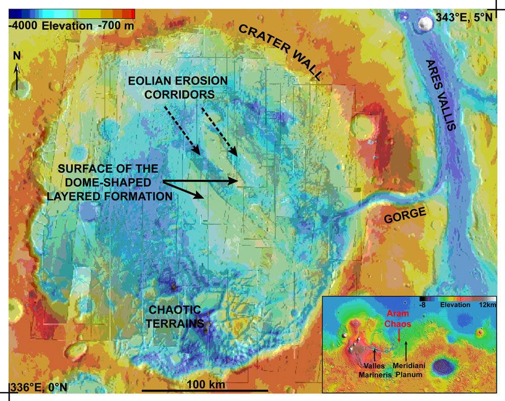
Aram Chaos region of Mars as imaged by the OMEGA instrument on board ESA's Mars Express (ESA)
[/caption]
The picture of Mars’ wet history is gradually becoming more comprehensive. This time, new observations by the European Space Agency’s Mars Express satellite have revealed concentrations of sulphates and ferric oxides in the 175 mile-wide (280 kilometres) Aram Chaos region, an ancient crater basin. Although the true nature of these compounds remain elusive, it could reveal past atmospheric precipitation, otherwise known as rain and snow…
Artist's impression of Mars Express (ESA)It is the mother of all planetary jigsaw puzzles, piecing together the geological and atmospheric evidence to better understand Martian history. Although we have hypothesised for some time about the presence of water in the regolith, it wasn’t until the Mars Phoenix Lander touched down in the Martian arctic in May 2008, dug a trench and detected water ice that we had proof of the existence of water on the surface. Observations made by the lander helped too, as it saw broken, regular shapes of a permafrost layer in the surrounding landscape (suggesting quantities of ice below the surface), and there is tantalizing evidence that liquid water brines may also exist at very low atmospheric pressures (with the help of perchlorate salts). It doesn’t stop there, Phoenix also confirmed that atmospheric ice may get large enough to fall as snow in arctic regions.
Now, from Mars orbit, the ESA Mars Express has used its OMEGA instrument (a.k.a. the Visible and Infrared Mineralogical Mapping Spectrometer) to map an equatorial region to gain clues about Martian history. The results beamed back to Earth are both exciting and a little peculiar.
It is well known that Mars is covered in ferric oxides, contained within the dust that blankets much of the planet. This is the compound that gives Mars its characteristic red hue. However, looking deep into the crater of Aram Chaos, there is a four-fold increase in the spectral signature of ferric oxides. This has led ESA scientists to believe this is indicative of a specific concentration mechanism. On Mars, ferric oxides are usually found with sulphates, but in this location, strong winds have blown away the lighter sulphates, leaving the ferric oxides behind, allowing the Mars Express spectrometer to measure the high concentrations.
On Earth, we commonly know ferric oxide as rust. Rust forms when there is a reaction between iron and atmospheric oxygen, facilitated by the presence of water.
“They have accumulated in dark deposits at the bottom of sulphate cliffs,” said Stephane Le Mouelic of the University of Nantes in France. This suggests that the ferric oxides have been uncovered by eolian (wind) erosion before being eroded themselves, dropping to the bottom of sulphate enriched cliffs. Driven by Martian winds, the ferric oxides went on to enrich dunes in the region.
Opportunity's blue berries, or ferric oxide deposits (NASA)It turns out the ferric oxide accumulation processes are not exclusive to Aram Chaos. According to observations by Mars rover Opportunity, there are ferric oxide concentrations in Meridiani Planum about 1000 km (600 miles) away. Also, Valles Marineris, about 3000 km (1900 miles) away appears to have similar deposits.
This is an intriguing study and it is possible that other regions will show similar accumulation processes, but are covered by other material. “OMEGA is sensitive to the first hundreds of microns of the surface. So, a layer of Martian dust just one millimeter thick will hide the signature from us,” said Marion Masse, also of the University of Nantes. Although OMEGA is restricted to hunting for ferric oxide deposits only in regions where rock is exposed due to wind action, this could be an important method to seek out how and where ferric oxides got deposited. Although scientists are keeping an open mind as to how these deposits formed, it could be due to atmospheric precipitation (rain or snow) or it could be down to volcanic ashes or glacial deposits.
Notice something new here on Universe Today? That’s right… There’s a new International Year of Astronomy logo in the right hand column and a video. If you’re wondering what “Galactic TV” is all about, then step inside…
The International Year of Astronomy 2009 is a global effort initiated by the International Astronomical Union (IAU) and UNESCO to help the citizens of the world rediscover their place in the Universe through the day- and night-time sky, and thereby engage a personal sense of wonder and discovery. Here at Universe Today, we believe in those goals set forth by the IYA founders, so we teamed together to give our readership something you’ll find nowhere else on Earth (or the web) – a live view of the Cosmos via a remote telescope.
Thanks to Internet magic, Universe Today, Northern and Southern Galactic and Warren Rupp Observatory have teamed together to base a small telescope in the southern hemisphere and broadcast a live television image of what the telescope is seeing through the eyepiece camera. Around 09:00 UT, (which is local dark time in Central Victoria, Australia) broadcasting will begin – and will continue non-stop until either daylight or clouds happen. If you tune in and there’s no image, that can only mean one of three things – it’s either clouded out, it’s daylight, or the connection has reached its limits of viewers and you’ll just have to try back in few minutes.
If you’ve ever wondered what southern sky gems look like, now is your chance to see them just as they appear at the moment. All you have to do is click on “LIVE Remote Cam” below the IYA logo. While these aren’t Hubble views, the small telescope and Stellacam are providing very clear looks at objects like you’ll see on the small screen replay of Omega Centauri! Check out this larger version…
If you miss out on a live broadcast of the International Year of Astronomy telescope, don’t despair. Each time the telescope is in operation we’ll take a video recording of each object, add some Wikipedia information and store it in the IYA “Live” Telescope Library! Broadcasts from the telescope will continue for the entire 2009 year and will feature everything from galaxies to double stars.
The International Year of Astronomy 2009 is a global celebration of astronomy and its contributions to society and culture and marks the 400th anniversary of the first use of an astronomical telescope by Galileo Galilei. The aim of the Year is to stimulate worldwide interest, especially among young people, in astronomy and science under the central theme “The Universe, Yours to Discover”. What better way to celebrate than to enjoy this virtual telescope and discover the beauty with your own eyes?