Where In The Universe #148

Here’s this week’s image for the Where In The Universe Challenge, to test your visual knowledge of the cosmos. You know what to do: take a look at this image and see if you can determine where in the universe this image is from; give yourself extra points if you can name the spacecraft/telescope responsible for the image. We’ll provide the image today, but won’t reveal the answer until later. This gives you a chance to mull over the image and provide your answer/guess in the comment section. Please, no links or extensive explanations of what you think this is — give everyone the chance to guess.

UPDATE: The answer has now been posted below.

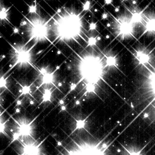
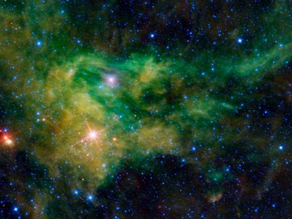
I admit, I too thought this was the Lights of Zetar at first glance, but then learned it is a Hubble close-up of ancient white dwarf stars in the Milky Way Galaxy. Hubble peered deep into the globular star cluster M4 and was able to detect the white dwarfs which are no more luminous than a 100-watt light bulb seen at the moon’s distance from Earth. Hubble reveals a total of 75 white dwarfs in one small area within M4 out of a total of about 40,000 white dwarfs that the cluster is predicted to contain.

See more info at the HubbleSite.

Where In The Universe Challenge #147

It’s time once more for another Where In The Universe Challenge. Name where in the Universe this image was taken and give yourself extra points if you can name the telescope or spacecraft responsible for the image. Post your guesses in the comments section, and check back on later at this same post to find the answer. To make this challenge fun for everyone, please don’t include links or extensive explanations with your answer. Good luck!

UPDATE: The answer has now been posted below.

This is Earth, showing a huge ocean of sand called the the Grand Erg Oriental (Eastern Sand Sea) in Algeria. It was taken by an astronaut on board the International Space Station in December 11, 2004, with a Kodak 760C digital camera with a 400 mm lens. See more images like this at the Astronaut Photography from Space website.

Where In The Universe Challenge #146

Here’s this week’s image for the Where In The Universe Challenge, to test your visual knowledge of the cosmos. You know what to do: take a look at this image and see if you can determine where in the universe this image is from; give yourself extra points if you can name the spacecraft/telescope responsible for the image. We’ll provide the image today, but won’t reveal the answer until later. This gives you a chance to mull over the image and provide your answer/guess in the comment section. Please, no links or extensive explanations of what you think this is — give everyone the chance to guess.

UPDATE: The answer has now been posted below!

Ah, its springtime on Mars’ southern hemisphere! This is Mars, as seen by the HiRISE camera on the Mars Reconnaissance Orbiter. Specifically, this is a “spot” near the south pole of Mars (-84.3 degrees latitude and 242.1 degrees east longitude) called the Starfish region. MRO is monitoring how warmer weather is changing the polar landscape.

And here’s a look at a bigger view of the area.

For more info on this image see the HiRISE website!

Where In The Universe Challenge #145

It’s time once again for another Where In The Universe Challenge. Name where in the Universe this image was taken and give yourself extra points if you can name the telescope or spacecraft responsible for the image. Post your guesses in the comments section, and check back on later at this same post to find the answer. To make this challenge fun for everyone, please don’t include links or extensive explanations with your answer. Good luck!

UPDATE: Answer now posted below!

This is planet Earth, specifically the Tassili n’Ajjer National Park, a part of the Sahara Desert, taken by the Landsat 7 satellite. Landsat 7 used a combination of infrared, near-infrared and visible light to better distinguish between the various rock types found in the region. Sand appears in shades of yellow and tan, while granite rocks appear brick red, and blue areas are likely salts. This area has a bone-dry climate with scant rainfall, but is not just a sea of sand like the rest of the Sahara Desert. Instead, the rocky plateau rises above the surrounding sand. Rich in geologic and human history, Tassili n’Ajjer is a United Nations Educational, Scientific and Cultural Organization (UNESCO) World Heritage Site, and covers 27,800 square miles (72,000 square kilometers) in southeastern Algeria.

This image is part of a special collection of images put out by NASA for Earth Day. See the entire collection at this link.

Where In The Universe Challenge #144

Here’s this week’s image for the Where In The Universe Challenge, to test your visual knowledge of the cosmos. You know what to do: take a look at this image and see if you can determine where in the universe this image is from; give yourself extra points if you can name the spacecraft/telescope responsible for the image. We’ll provide the image today, but won’t reveal the answer until later. This gives you a chance to mull over the image and provide your answer/guess in the comment section. Please, no links or extensive explanations of what you think this is — give everyone the chance to guess.

UPDATE: Answer is now posted below.

This is a closeup of part of the Helix Nebula, or NGC 7293. Produced in 2003, at the time it was one of the largest and most detailed celestial images ever made. The composite picture is a seamless blend of ultra-sharp images from NASA’s Hubble Space Telescope combined with the wide view of the Mosaic Camera on the National Science Foundation’s 0.9-meter telescope at Kitt Peak National Observatory near Tucson, Ariz. See more info on this picture at the HubbleSite.

Where In The Universe Challenge #143

It’s time once again for another Where In The Universe Challenge. Name where in the Universe this image was taken and give yourself extra points if you can name the telescope or spacecraft responsible for the image. Post your guesses in the comments section, and check back on later at this same post to find the answer. To make this challenge fun for everyone, please don’t include links or extensive explanations with your answer. Good luck!

UPDATE: The answer is now posted below.

This trillobite-like feature showed up on a magnetic map of emerging sunspot 10926 recorded by the Hinode spacecraft in Dec. 2006. You can download a 5MB movie of the formation of this sunspot at this link. The picture, and the movie, are a magnetogram—a dynamic map tracing the sunspot’s intense magnetism. Black represents negative (S) polarity, and white represents positive (N).

Scientists said they had never seen anything like this kind of feature before. Read more about it on the Science@NASA website.

Where In The Universe Challenge #142

Ready for another Where In The Universe Challenge? Here’s #142! Take a look and see if you can name where in the Universe this image is from. Give yourself extra points if you can name the spacecraft, telescope or instrument responsible for the image. We provide the image today, but won’t reveal the answer until later. This gives you a chance to mull over the image and provide your answer/guess in the comment section. And Please, no links or extensive explanations of what you think this is — give everyone the chance to guess.

UPDATE: The answer has now been posted below!

This is a “colorized” image of Venus was taken on February 14th, 1990 by the Galileo spacecraft. It was taken from a distance of almost 1.7 million miles, about 6 days after Galileo’s closest approach to the planet. In order to be able to see the subtle contrasts in the clouds in Venus’ upper atmosphere, scientists colorized to a bluish hue, as well as to indicate that it was taken through a UV filter.

This image shows the east-to-west-trending cloud banding, and scientists estimate the winds that flow from east to west are gusting at about 230mph. The smallest features visible are about 45 miles across. Scientists point out an intriguing filimentary dark pattern is seen immediately left of the bright region at the subsolar point (equatorial “noon”). North is at the top and the evening terminator is to the left.

See the original image on the NSSDC Photo Gallery.

Where In The Universe Challenge #141

Icy, cold, and lonely

It’s time once more for another Where In The Universe Challenge (sorry for the short hiatus…) Name where in the Universe this image was taken and give yourself extra points if you can name the telescope or spacecraft responsible for the image. Post your guesses in the comments section, and check back on later at this same post to find the answer. To make this challenge fun for everyone, please don’t include links or extensive explanations with your answer. Good luck!

UPDATE: The answer is now posted below:

It took awhile, but readers finally figured this one out! This our Moon as seen from the MESSENGER spacecraft back on July 31, 2005, less than a year after it launched. As you know, MESSENGER is now successfully in orbit around Mercury (yay!) but at the time this image was taken, the spacecraft was about 992,814 kilometers (616,906 miles) from the Earth on its circuitous route to Mercury.

This image was featured on the Lunar Reconnaissance Orbiter website last week in honor of MESSENGER’s successful orbit insertion. As the LROC website says, this image was not taken simply because the Moon is beautiful and inspiring; it served to help the MESSENGER team calibrate the camera and spectrometer. The Moon is a good calibration standard because its reflectance and color have been measured with many instruments, so it is useful to make comparisons between instruments with different characteristics.

So congrats to the MESSENGER team — who will certainly henceforth be concentrating on Mercury!

And you can find the answer to the previous WITU challenge back on the original post.

Where In The Universe Challenge #140

It’s time once again for another Where In The Universe Challenge. Name where in the Universe this image was taken and give yourself extra points if you can name the telescope or spacecraft responsible for the image. Post your guesses in the comments section, and check back on later at this same post to find the answer. To make this challenge fun for everyone, please don’t include links or extensive explanations with your answer. Good luck!

UPDATE: The answer has been posted below.

This is the nebula BFS 29 surrounding the star CE-Camelopardalis, as seen by the WISE spacecraft. This nebula can be found hovering in the band of the night sky comprising the Milky Way. “BFS” stands for Blitz, Fich, and Stark — the three astronomers who identified and cataloged this nebula back in 1982. The “29” means that it’s the 29th object in their catalog. Learn more about this image on the WISE website.

Where In The Universe Challenge #139

It’s time once again for another Where In The Universe Challenge. Name where in the Universe this image was taken and give yourself extra points if you can name the telescope or spacecraft responsible for the image. Post your guesses in the comments section, and check back on later at this same post to find the answer. To make this challenge fun for everyone, please don’t include links or extensive explanations with your answer. Good luck!

UPDATE: The answer has now been posted below.

This is an image from the Cassini spacecraft of vertical structures in Saturn’s main rings. These unexpected structures rise abruptly from the edge of Saturn’s B ring to cast long shadows on the ring. This image was taken in 2009.

Part of the Cassini Division, between the B and the A rings, appears at the top of the image, showing ringlets in the inner division. Cassini’s narrow angle camera captured a 1,200-kilometer-long (750-mile-long) section arcing along the outer edge of the B ring, and it is estimated the vertical structures tower as high as 2.5 kilometers (1.6 miles) above the plane of the rings — a significant deviation from the vertical thickness of the main A, B and C rings, which is generally only about 10 meters (about 30 feet).

See more about the image on the Cassini website.