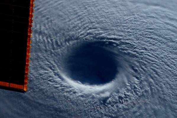
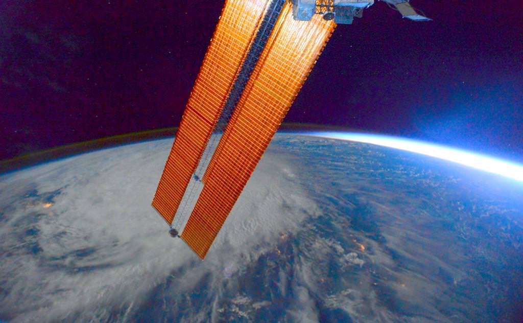
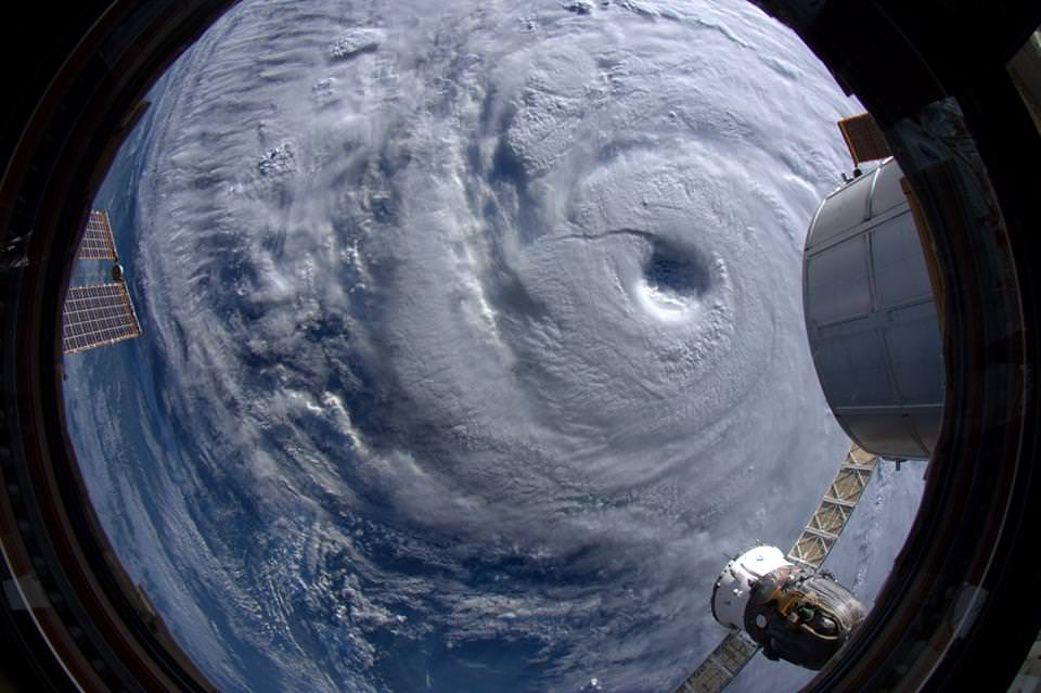
Maysak, a category 4 Super Typhoon, as photographed by astronaut Terry Virts on board the International Space Station. Credit: NASA/Terry Virts.
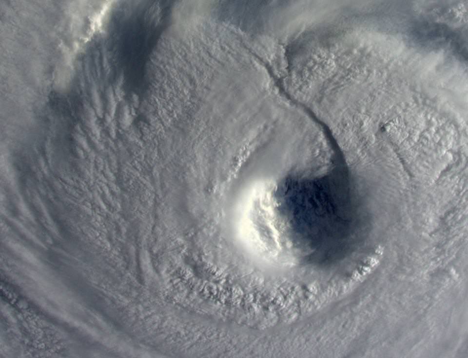
From his perch on the International Space Station, astronaut Terry Virts has been taking some beautiful photos of Earth and space and sharing them on social media. Today, he shared his views of Super Typhoon Maysak, including this terrifying view looking straight down into the huge eye of the storm. “Looking down into the eye – by far the widest one I’ve seen,” he tweeted. “It seemed like a black hole from a Sci-Fi movie.”
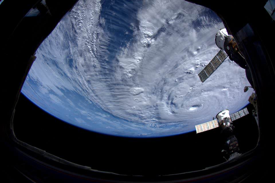
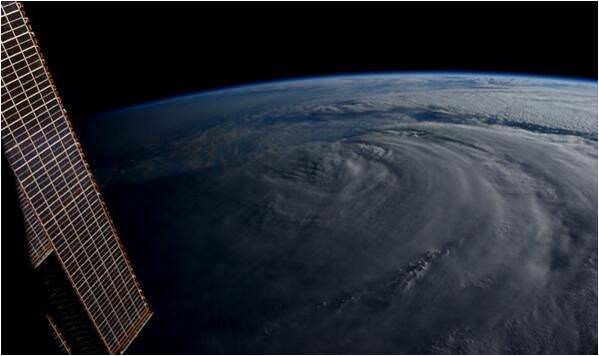
See more of his images, below.
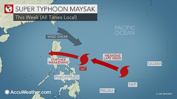
According to AccuWeather.com, Super Typhoon Maysak is one of the strongest cyclones in history during the months of January, February and March. It has slammed several Micronesian islands, killing 5 people, and is now on its way to the Philippines. As of early on April 1, Maysak had sustained winds of 240 kph (150 mph), equivalent of a Category 4 hurricane. Gusts as high as 390 kph (180 mph) are possible with this storm.
Looking down into the eye – by far the widest one I’ve seen. It seemed like a black hole from a Sci-Fi movie #Maysakpic.twitter.com/hmdBStaY6r
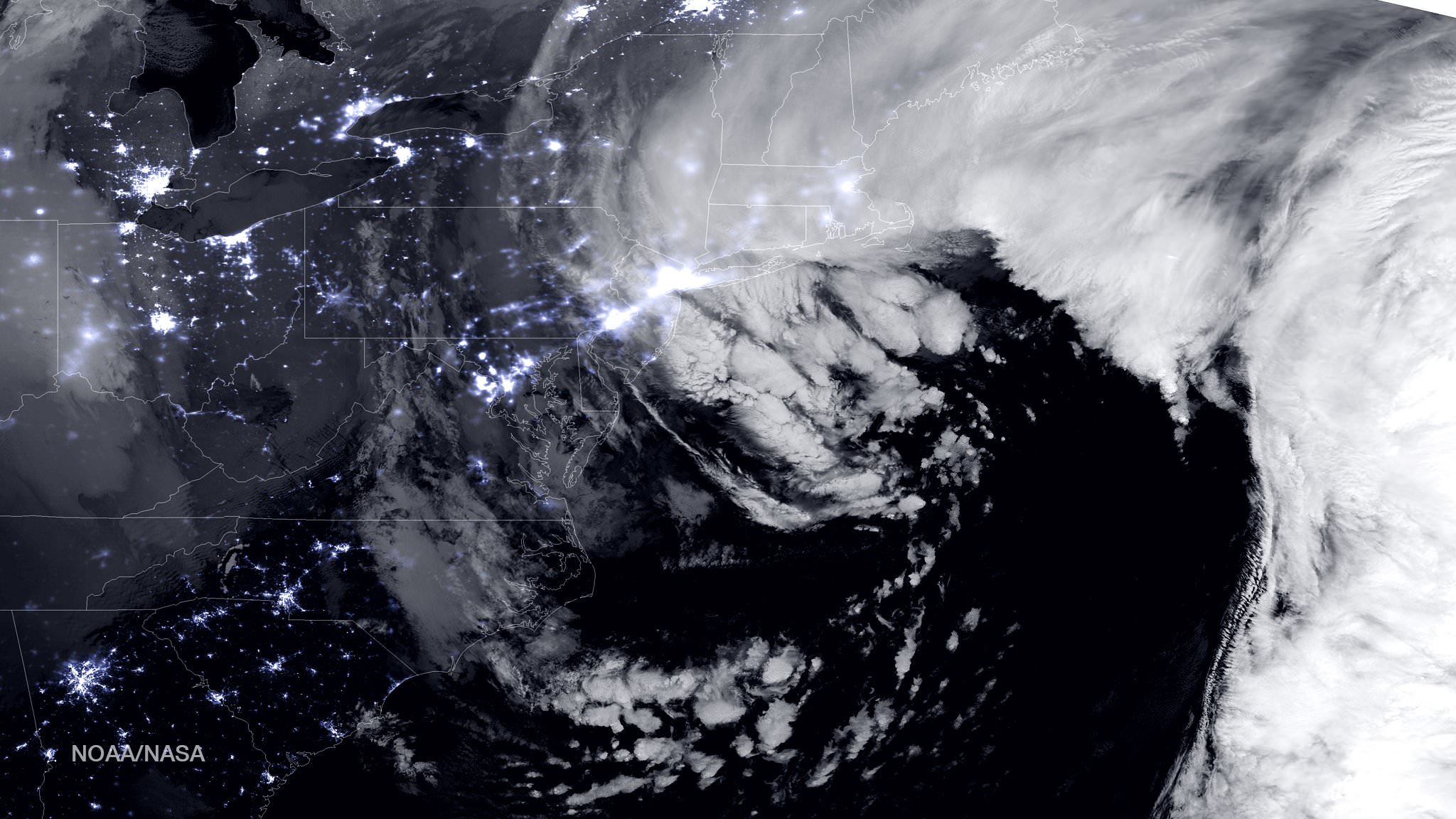
NASA-NOAA Suomi NPP satellite captures blizzard near peak intensity as it moves over New York and Boston regions at 1:45 am EST, Jan. 27, 2015. This view is a combination of the day-night band and high resolution infrared imagery from Suomi NPP showing the historic blizzard near peak intensity as it moves over the New York through Boston Metropolitan areas at 06:45Z (1:45 a.m. EST) on January 27, 2015. Credit: NOAA/NASA
NEW JERSEY – Record breaking snow from the ‘Blizzard of 2015’ hit vast regions of the US Northeast today, Jan. 27, 2015, stretching from Long Island to New England.
NASA and NOAA Earth orbiting satellites are keeping track of the storm affecting millions of residents.
This afternoon the agencies provided a new set of night-time and daytime views of the Blizzard of 2015 taken by the Suomi NPP and the GOES-East satellites.
The crippling blizzard is causing misery, extensive destruction to homes and businesses in localized areas, power outages, traffic accidents, breaks in some sea walls and deaths.
The satellite image above shows a combination of the day-night band and high resolution infrared imagery from the NASA-NOAA’s Suomi NPP satellite.
It was taken as the historic blizzard neared peak intensity as it moved over the New York area and through the Boston Metropolitan areas at 06:45Z (1:45 a.m. EST) on January 27, 2015.
The high cloud tops from the most intense parts of the storm blurred the regions normally bright nighttime lights in the satellite image.
Although the snow totals were about half the over two feet forecast for the New York Metropolitan region, many areas to the north and east were inundated with very heavy to historic snow fall totals, as bad or worse than the forecasters predicted.
Over two feet of snow fell on areas of New York’s Long Island and stretching north to vast regions of Connecticut, Massachusetts, New Hampshire and into Maine.
Near hurricane force waves are crashing into some coastal towns along the Massachusetts shoreline. Wind gusts as high as 78 mph have been recorded.
“Highest snowfall report has been Auburn, MA with 32.5 inches! Wind gust reports as high as 78 mph in Nantucket, MA,” according to a tweet this evening from the National Weather Service (NWS).
Worchester, Mass had a record breaking 31 inches of snow. And it’s still falling this evening in the 2nd largest city in New England.
A flood emergency is in effect in Marshfield, Mass., where an 80 foot section of the seawall was smashed by crashing waves and is destroying homes as shown on NBC Nightly News.
Blinding snow is raging in Portland, Maine this evening according on a live NBC News report.
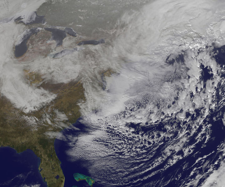
On January 27, 2015 at 17:35 UTC (12:35 p.m. EST) NOAA’s Geostationary Operational Environmental or GOES- East satellite captured an image of the nor’easter over New England. Credit: NASA/NOAA GOES Project
“At 10 a.m. EST, the National Weather Service noted “the powerful nor’easter that brought moderate to heavy snowfall and blizzard conditions to the Northeast on Monday will continue to affect the region on Tuesday, with heavy snow and blizzard conditions expected from eastern Long Island to Maine as the system slowly moves to the northeast. Snow and strong winds will being tapering off from south to north Tuesday night into Wednesday morning,” wrote NASA’s Rob Gutro of NASA’s Goddard Space Flight Center in an update.
“Later on January 27, 2015 at 17:35 UTC (12:35 p.m. EST) NOAA’s Geostationary Operational Environmental or GOES-East satellite captured an image of the nor’easter over New England. The image was created by the NASA/NOAA GOES Project and showed the clouds associated with the nor’easter blanketing New England. An occluded front extended north and eastward out of the low pressure area’s center out into the Atlantic Ocean.”
The latest NOAA forecast as of 4 PM, Jan. 27 states:
HIGH WINDS AND HEAVY SNOW WILL BEGIN TO GRADUALLY TAPER OFF FROM SOUTH TO NORTH TONIGHT…BUT WILL LAST INTO EARLY WEDNESDAY MORNING ACROSS PORTIONS OF MAINE. HEAVY SNOWFALL WILL COMBINE WITH SUSTAINED WINDS OF 30 TO 40 MPH…AND GUSTS IN EXCESS OF 50 MPH…TO CREATE LIFE-THREATENING WHITEOUT OR BLIZZARD CONDITIONS. THESE WINDS MAY LEAD TO DOWNED TREES AND POWER LINES RESULTING IN POWER OUTAGES. TRAVEL WILL BE IMPOSSIBLE AND LIFE-THREATENING IN MANY AREAS. ALONG THE IMMEDIATE COASTLINE…WIND GUSTS TO NEAR 65 MPH WILL BE POSSIBLE. COASTAL FLOODING AND SEVERE BEACH EROSION WILL ALSO BE A POSSIBILITY…AND VULNERABLE ROADS AND STRUCTURES MAY BE FLOODED OR DAMAGED.
Stay tuned here for Ken’s continuing Earth and planetary science and human spaceflight news.
An artistic image of the explosion of a star leading to a gamma-ray burst. (Source: FUW/Tentaris/Maciej Fro?ow)
Gamma ray bursts (GRBs) are some of the brightest, most dramatic events in the Universe. These cosmic tempests are characterized by a spectacular explosion of photons with energies 1,000,000 times greater than the most energetic light our eyes can detect. Due to their explosive power, long-lasting GRBs are predicted to have catastrophic consequences for life on any nearby planet. But could this type of event occur in our own stellar neighborhood? In a new paper published in Physical Review Letters, two astrophysicists examine the probability of a deadly GRB occurring in galaxies like the Milky Way, potentially shedding light on the risk for organisms on Earth, both now and in our distant past and future.
There are two main kinds of GRBs: short, and long. Short GRBs last less than two seconds and are thought to result from the merger of two compact stars, such as neutron stars or black holes. Conversely, long GRBs last more than two seconds and seem to occur in conjunction with certain kinds of Type I supernovae, specifically those that result when a massive star throws off all of its hydrogen and helium during collapse.
Perhaps unsurprisingly, long GRBs are much more threatening to planetary systems than short GRBs. Since dangerous long GRBs appear to be relatively rare in large, metal-rich galaxies like our own, it has long been thought that planets in the Milky Way would be immune to their fallout. But take into account the inconceivably old age of the Universe, and “relatively rare” no longer seems to cut it.
In fact, according to the authors of the new paper, there is a 90% chance that a GRB powerful enough to destroy Earth’s ozone layer occurred in our stellar neighborhood some time in the last 5 billion years, and a 50% chance that such an event occurred within the last half billion years. These odds indicate a possible trigger for the second worst mass extinction in Earth’s history: the Ordovician Extinction. This great decimation occurred 440-450 million years ago and led to the death of more than 80% of all species.
Today, however, Earth appears to be relatively safe. Galaxies that produce GRBs at a far higher rate than our own, such as the Large Magellanic Cloud, are currently too far from Earth to be any cause for alarm. Additionally, our Solar System’s home address in the sleepy outskirts of the Milky Way places us far away from our own galaxy’s more active, star-forming regions, areas that would be more likely to produce GRBs. Interestingly, the fact that such quiet outer regions exist within spiral galaxies like our own is entirely due to the precise value of the cosmological constant – the factor that describes our Universe’s expansion rate – that we observe. If the Universe had expanded any faster, such galaxies would not exist; any slower, and spirals would be far more compact and thus, far more energetically active.
In a future paper, the authors promise to look into the role long GRBs may play in Fermi’s paradox, the open question of why advanced lifeforms appear to be so rare in our Universe. A preprint of their current work can be accessed on the ArXiv.
Typhoon Hagupit seen from the International Space Station on Dec. 6, 2014. Credit: Terry Virts/Twitter
As a million people fled their homes in the Philippines, astronauts on the International Space Station could clearly see the cause of the disruption — Typhoon Hagupit, which struck the chain of Asian islands this weekend.
“This storm looks incredibly dangerous — praying for the people of the Philippines,” wrote Expedition 42 astronaut Terry Virts in one of a series of pictures he tweeted from space yesterday (Dec. 6). Three deaths have been reported in media so far in the Philippines due to the storm.
The Category 3 storm is called “Ruby” among the locals. As always, weather agencies around the world are providing forecasts as they can through satellite imagery. Virts sent several pictures from space, which you can see below.
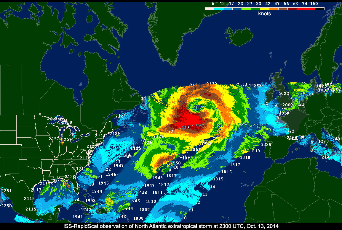
ISS-RapidScat data on a North Atlantic extratropical cyclone, as seen by the National Centers for Environmental Prediction Advanced Weather Interactive Processing System used by weather forecasters at the National Oceanic and Atmospheric Administration's Ocean Prediction Center.
Image Credit:
NASA/JPL-Caltech/NOAA
Barely two months after being launched to the International Space Station (ISS), NASA’s first science payload aimed at conducting Earth science from the station’s exterior has started its ocean wind monitoring operations two months ahead of schedule.
Data from the ISS Rapid Scatterometer, or ISS-RapidScat, payload is now available to the world’s weather and marine forecasting agencies following the successful completion of check out and calibration activities by the mission team.
Indeed it was already producing high quality, usable data following its power-on and activation at the station in late September and has monitored recent tropical cyclones in the Atlantic and Pacific Oceans prior to the end of the current hurricane season.
RapidScat is designed to monitor ocean winds for climate research, weather predictions, and hurricane monitoring for a minimum mission duration of two years.
“RapidScat is a short mission by NASA standards,” said RapidScat Project Scientist Ernesto Rodriguez of JPL.
“Its data will be ready to help support U.S. weather forecasting needs during the tail end of the 2014 hurricane season. The dissemination of these data to the international operational weather and marine forecasting communities ensures that RapidScat’s benefits will be felt throughout the world.”
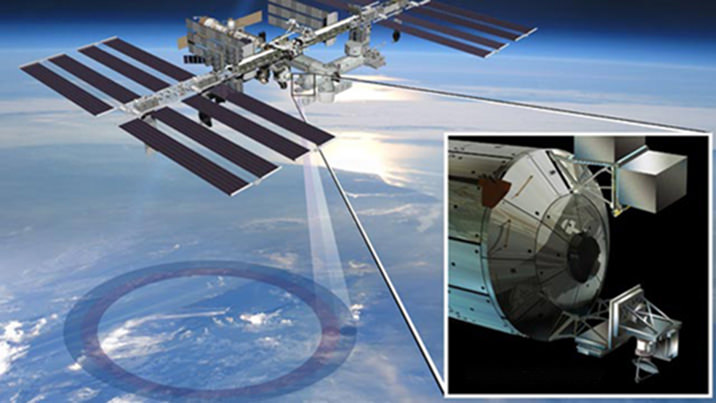
ISS-RapidScat instrument, shown in this artist’s rendering, was launched to the International Space Station aboard the SpaceX CRS-4 mission on Sept. 21, 2014, and attached at ESA’s Columbus module. It will measure ocean surface wind speed and direction and help improve weather forecasts, including hurricane monitoring. Credit: NASA/JPL-Caltech/Johnson Space Center.
The 1280 pound (580kilogram) experimental instrument was developed by NASA’s Jet Propulsion Laboratory. It’s a cost-effective replacement to NASA’s former QuikScat satellite.
The $26 million remote sensing instrument uses radar pulses reflected from the ocean’s surface at different angles to calculate the speed and direction of winds over the ocean for the improvement of weather and marine forecasting and hurricane monitoring.
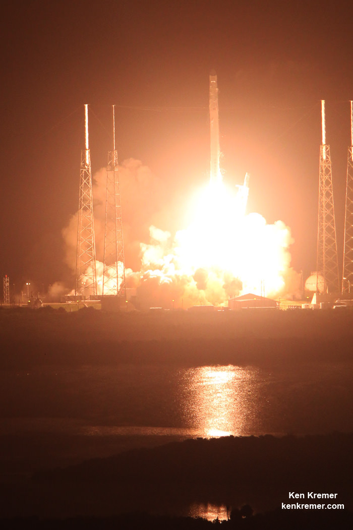
The RapidScat, payload was hauled up to the station as part of the science cargo launched aboard the commercial SpaceX Dragon CRS-4 cargo resupply mission that thundered to space on the company’s Falcon 9 rocket from Space Launch Complex-40 at Cape Canaveral Air Force Station in Florida on Sept. 21.
ISS-RapidScat is NASA’s first research payload aimed at conducting near global Earth science from the station’s exterior and will be augmented with others in coming years.
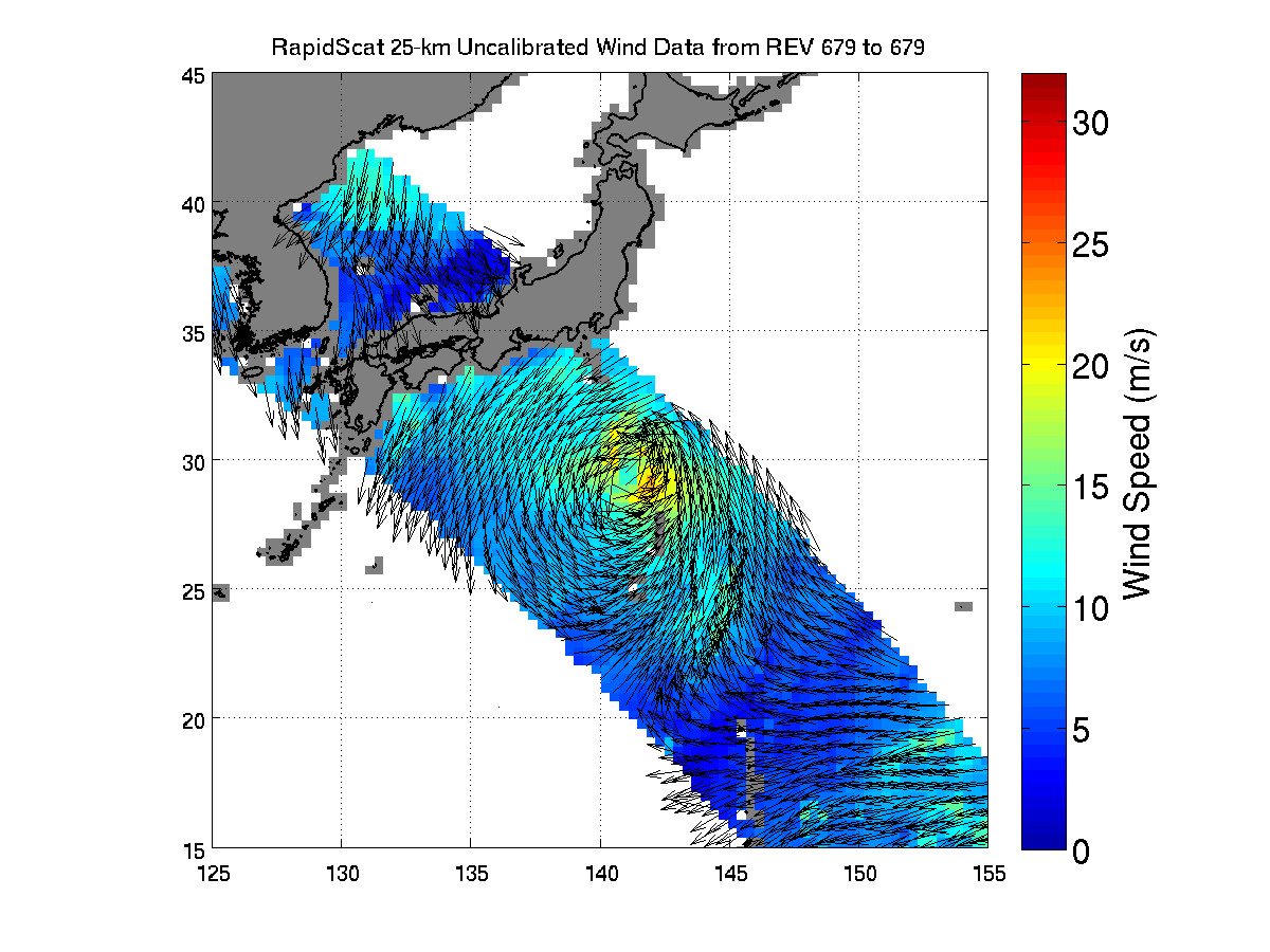
ISS-RapidScat viewed the winds within post-tropical cyclone Nuri as it moved parallel to Japan on Nov. 6, 2014, 05:30 UTC. Image Credit: NASA/JPL-Caltech
It was robotically assembled and attached to the exterior of the station’s Columbus module using the station’s robotic arm and DEXTRE manipulator over a two day period on Sept 29 and 30.
Ground controllers at Johnson Space Center intricately maneuvered DEXTRE to pluck RapidScat and its nadir adapter from the unpressurized trunk section of the Dragon cargo ship and attached it to a vacant external mounting platform on the Columbus module holding mechanical and electrical connections.
The nadir adapter orients the instrument to point its antennae at Earth.
The couch sized instrument and adapter together measure about 49 x 46 x 83 inches (124 x 117 x 211 centimeters).
“The initial quality of the RapidScat wind data and the timely availability of products so soon after launch are remarkable,” said Paul Chang, ocean vector winds science team lead at NOAA’s National Environmental Satellite, Data and Information Service (NESDIS)/Center for Satellite Applications and Research (STAR), Silver Spring, Maryland.
“NOAA is looking forward to using RapidScat data to help support marine wind and wave forecasting and warning, and to exploring the unique sampling of the ocean wind fields provided by the space station’s orbit.”
A SpaceX Falcon 9 rocket carrying a Dragon cargo capsule packed with science experiments and station supplies blasts off from Space Launch Complex 40 at Cape Canaveral Air Force Station, Florida, at 1:52 a.m. EDT on Sept. 21, 2014, bound for the ISS. Credit: Ken Kremer/kenkremer.com
This has been a banner year for NASA’s Earth science missions. At least five missions will be launched to space within a 12 month period, the most new Earth-observing mission launches in one year in more than a decade.
ISS-RapidScat is the third of five NASA Earth science missions scheduled to launch over a year.
NASA has already launched the of the Global Precipitation Measurement (GPM) Core Observatory, a joint mission with the Japan Aerospace Exploration Agency, in February and the Orbiting Carbon Observatory-2 (OCO-2) carbon observatory in July 2014.
Stay tuned here for Ken’s continuing Earth and Planetary science and human spaceflight news.
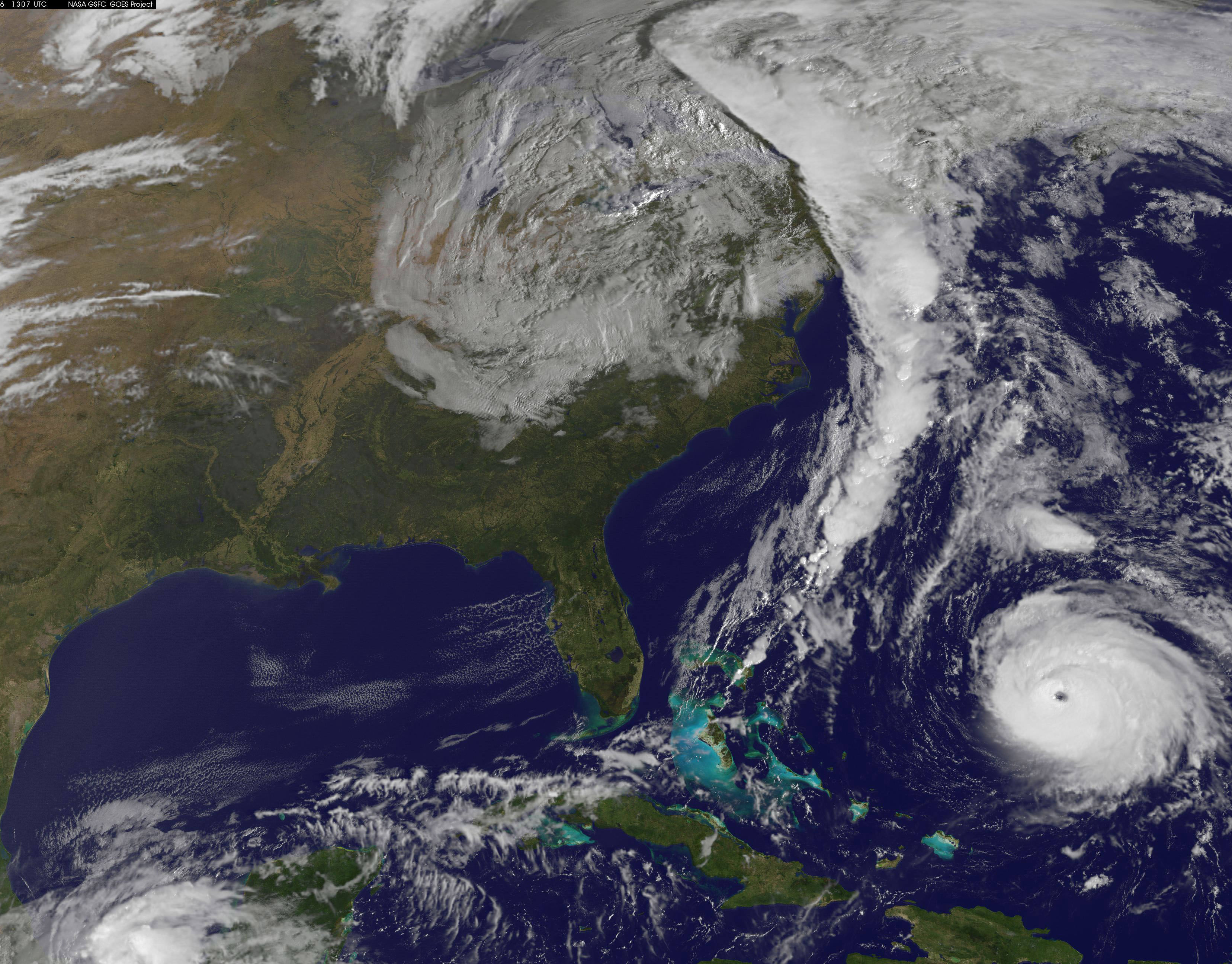
NOAA's GOES-East satellite captured this image of Hurricane Gonzalo off the U.S. East Coast on Oct. 16 at 13:07 UTC (9:07 a.m. EDT). Gonzalo is classified as Category 4 storm. Credit: NASA/NOAA GOES Project
Hurricane Gonzalo, the first major Atlantic Ocean basin hurricane in three years, has strengthened to a dangerous Category 4 storm, threatening Bermuda and forcing a postponement of the upcoming launch of the Orbital Sciences Antares rocket to the space station from the Virginia shore to no earlier than Oct. 27.
A hurricane warning is in effect for the entire island of Bermuda.
NASA and Orbital Sciences had no choice but to delay the Antares blastoff from Oct. 24 to no earlier than Oct. 27 because Bermuda is home to an “essential tracking site” that must be operational to ensure public safety in case of a launch emergency situation.
Antares had been slated for an early evening liftoff with the Cygnus cargo carrier on the Orb-3 mission to the International Space Station (ISS).
NASA and Orbital issued the following statement:
“Due to the impending arrival of Hurricane Gonzalo on the island of Bermuda, where an essential tracking site used to ensure public safety during Antares launches is located, the previously announced “no earlier than” (NET) launch date of October 24 for the Orb-3 CRS mission to the International Space Station for NASA is no longer feasible.”
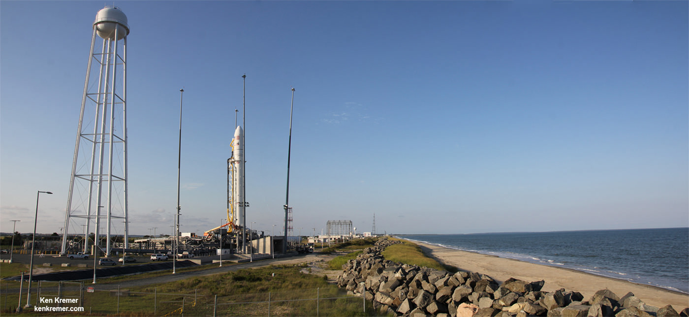
Orbital Sciences Corporation Antares rocket and Cygnus spacecraft prior to blast off on July 13 2014 from Launch Pad 0A at NASA Wallops Flight Facility , VA, on the Orb-2 mission bound for the International Space Station. Credit: Ken Kremer – kenkremer.com
The powerful Gonzalo is currently expected to make a direct hit on Bermuda on Friday afternoon, Oct. 17. It’s packing devastating maximum sustained winds exceeding 145 mph (225 kph).
NASA and NOAA satellites including the Terra, Aqua and GOES-East satellites are providing continuous coverage of Hurricane Gonzalo as it moves toward Bermuda, according to a NASA update today.
The ISS-RapidScat payload tracking ocean winds, that was just attached to the exterior of the ISS, is also designed to help with hurricane monitoring and forecasting.
Tropical storm force winds and 20 to 30 foot wave heights are expected to impact Bermuda throughout Friday and continue through Saturday and into Sunday.
“The National Hurricane Center expects hurricane-force winds, and rainfall totals of 3 to 6 inches in Bermuda. A storm surge with coastal flooding can be expected in Bermuda, with large and destructive waves along the coast. In addition, life-threatening surf and riptide conditions are likely in the Virgin Islands, Puerto Rico, Dominican Republic, Bahamas. Those dangerous conditions are expected along the U.S. East Coast and Bermuda today, Oct. 16,” according to NASA.
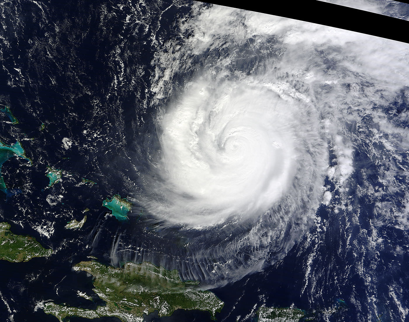
On Oct. 15 at 15:30 UTC (11:30 a.m. EDT) NASA’s Terra satellite captured this image of Hurricane Gonzalo in the Atlantic Ocean. Credit: NASA Goddard MODIS Rapid Response Team
After the hurricane passes, a team will be sent to assess the impact of the storm on Bermuda and the tracking station. Further delays are possible if Bermuda’s essential infrastructure systems are damaged, such as power, transportation and communications.
The Antares/Cygnus rocket and cargo ship launch from the Mid-Atlantic Regional Spaceport at NASA’s Wallops Flight Facility along the eastrn shore of Virginia.
Liftoff is currently target for October 27 at 6:44 p.m. (EDT). The rendezvous and berthing of Cygnus with the ISS remains on November 2, with grapple of the spacecraft by the station’s robotic arm at approximately 4:58 a.m. (EST), according to a NASA update.
Stay tuned here for Ken’s continuing Earth and Planetary science and human spaceflight news.
Oh, to be a stranded astronaut on the surface of the planet Mars this week. There’s a great scene from Andy Weir’s recent novel The Martian where chief protagonist Mark Watney uses the swift moving moons of Phobos and Deimos to roughly gauge his direction while travelling across the expansive Martian desert.
This week, the skies over Mars will also be graced by an unforgettable and spectacular sight: the extremely close passage of Comet C/2013 A1 Siding Spring. The first comet discovered in 2013, A1 Siding Spring was spotted by veteran comet hunter Robert McNaught from the Siding Spring Observatory in Australia. Dozens of comets are discovered in any given year, but this one soon gained the attention of astronomers when it was found that the comet could possibly hit Mars in October 2014.
And although further observations refined A1 Siding Spring’s orbit and ruled out such an impact, the particulars of the close passage of the comet past Mars are still stunning: A1 Siding Spring will pass within 87,000 miles (139,500 kilometres) from the center of Mars on Sunday, October 19th at 18:27 Universal Time (UT) or 2:27 PM EDT.
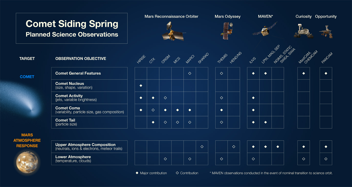
And although we’ve yet to set “boots” on Mars, a fleet of spacecraft arrayed throughout the inner solar system are set to study the comet from both near and far. NASA has taken measures to assure that spacecraft in orbit are afforded maximum protection from incoming cometary debris, and the exciting possibility exists that we’ll be able to study first-hand the interaction of the comet’s tail with the Martian atmosphere.
Mars-based spacecraft set to observe Comet A1 Siding Spring: a scorecard. Credit: NASA.
Universe Today has written extensively on the scientific efforts to study the event, how to observe the comet from Earth, and the unprecedented amateur and professional campaign in progress to witness the close pass.
What we’d like to do now is imagine the unparalleled view under alien skies as the comet slides gracefully overhead.
The nucleus of A1 Siding Spring is thought to be 700 metres across, and the coma extends 19,300 km in diameter. The comet’s closest passage is just under six times the distance of Mars’ outer moon Deimos, and at closest approach, the coma will appear almost 8 degrees in size to any would-be Martian — that’s 16 times the diameter of a Full Moon as seen from the Earth — and will be crossing the skies at a staggering 1.5 degrees a minute. You would be able to easily see the motion of the comet as it moves across the Martian sky with the unaided (well, space suit helmet protected) eye after just a few dozen seconds worth of watching! The comet’s magnitude may reach -5 as seen from Mars, though that would also be extended over its huge expanded surface area.
The enormous tail of the comet would also span the sky, and NASA has already released several mind blowing simulations to this effect. We’ve also constructed some brief simulations using Starry Night that show the view of the encounter from Earth, Phobos, and the perspective from the comet itself:
There’s also been some discussion as of late that A1 Siding Spring has slowed down in terms of its predicted brightening, though this is not unusual or unexpected.
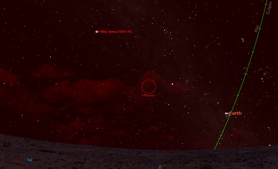
From Acidalia Planitia (the setting for The Martian) located in the mid-northern latitudes on the surface of Mars, the comet would be a fine morning object, sitting 48 degrees above the northeastern horizon at dawn at closest passage for one morning only, and perhaps staying visible even after sunrise. Earth would be in the picture too, shining at magnitude -2.5 in the Martian dawn.
Dawn on October 19th, 2014, as seen from Mars. Created using Starry Night.
And the view from the comet? Now that would be a truly spectacular ride, as Mars swells to 3 degrees in diameter as it approaches and recedes. The comet itself is on a million year plus orbit, never to again visit the realm of the inner solar system in our lifetimes.
Such a view has never been seen in recorded history from the Earth. The closest confirmed passage of a large comet near our planet was Comet D/1770 L1 Lexell, which passed over 15 times more distant than A1 Siding Spring from Mars, at 2.2 million km from Earth on July 1st, 1770. Note that an even closer cometary passage in 1491 remains unverified. In more recent times, Comet Hyakutake passed 15.8 million km from Earth on March 25th, 1996, with a tail that spanned half the sky as seen from a dark sky site, and long-time comet observers might also remember the 1983 passage of Comet IRAS-Araki-Alcock, which passed just 4.7 million kilometres from the Earth.
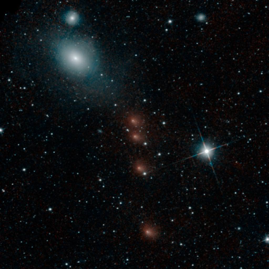
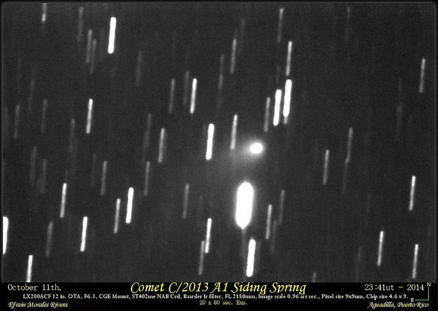
A1 Siding Spring imaged from Earth on October 11th, 2014. Credit: Efrain Morales Rivera.
And then there was the historic impact on Comet Shoemaker-Levy 9 into Jupiter in 1994, reminding us that cosmic catastrophes can and do indeed occur… the upper size limit estimate for the nucleus of A1 Siding Spring compares to 70% the size of Fragment G, and an impact on Earth or Mars of such a dirty snowball would be a very bad day, for rovers or the humans. An extinction level event such as the Chicxulub impactor, however, was estimated to be much larger, at about 10 km in size.
A1 Siding Springs as imaged on September 3rd, 2014. Credit: Roger Hutchinson.
Thankfully, we’ve merely got a front row seat to the show this weekend, and our planet is not the main event. From Earth, Comet A1 Siding Spring will be a binocular object, shining at magnitude +9 as it passes 3’ from +0.9 magnitude Mars. Both will be visible briefly in dusk skies, and the Virtual Telescope Project also plans to broadcast the event live starting at 16:45 UT on October 19th.
Don’t miss the historic passage of Comet A1 Siding Spring past Mars… by this time next week, we fully expect more images of the comet — both amateur and professional — to grace the cyber-pages of Universe Today!
Imaging A1 Siding Spring and/or Mars? Send those astro-pics into Universe Today at our Flickr forum.
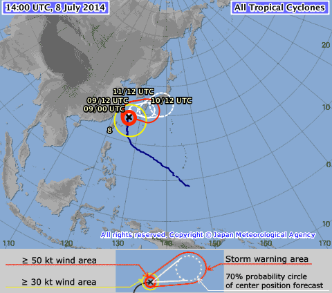
“Watch Out Japan!” added Gerst while he and his crewmates working aboard the ISS send back breathtaking imagery of the gigantic super typhoon heading towards Japan.
Neoguri is currently lashing the Japanese island of Okinawa with powerful damaging winds of over 125 mph and heavy downpours of flooding rain.
The Joint Typhoon Warning Center or JTWC reports that Neoguri is creating large and dangerous swells with wave heights to 37 feet (11.2 meters).
CNN reports today, July 8, that over 600,000 people have been told to evacuate and over 100,000 already have no power. Gusts have reached 212 kph (132 mph),
“Supertyphoon Neoguri did not even fit into our fisheye lens view. I have never seen anything like this.” Taken from the ISS on 8 July 2014. Credit: ESA/NASA/Alexander Gerst
The storm is so big it could not even be captured in a single image taken today using the astronauts fisheye lens on the ISS.
“Supertyphoon Neoguri did not even fit into our fisheye lens view. I have never seen anything like this,” reports Gerst today, July 8.
And the worst may be yet to come as Neoguri is forecast to make landfall on Kyushu, the southernmost island of the Japanese mainland and home to more than 13 million people after 0000 UTC on July 10 (8 p.m. EDT on July 9).
Super Typhoon Neoguri formed in the western Pacific Ocean south-southeast of Guam on July 3, 2014, according to NASA.
ISS above Supertyphoon Neoguri. Taken from the ISS on 7 July 2014. Credit: ESA/NASA/Alexander Gerst
By July 5 it had maximum sustained winds near 110 knots (127 mph).
The NASA and Japan Aerospace Exploration Agency’s Tropical Rainfall Measuring Mission or TRMM satellite passed over the typhoon on Monday, July 7. It was classified as a category four typhoon on the Saffir-Simpson hurricane scale with sustained winds estimates at 135 knots (155 mph), says NASA.
The eerie looking eye is 65 kilometers (40 miles) in diameter. See photo.
“Scary. The sunlight is far from reaching down the abyss of Neoguri’s 65 km-wide eye.” Taken from the ISS on 8 July 2014. Credit: ESA/NASA/Alexander Gerst
It has since decreased slightly in intensity to a category three typhoon.
According to the Japanese Meteorological Agency Neoguri is currently located at 28°55′ (N) and E125°50′ (E).
At 5:02 PM EDT today, July 8, NASA just reported that the ISS flew directly over Neoguri and may have been visible in the new live HDEV cameras residing on the stations truss.
“Neoguri has been literally cut in half. Unreal.” Taken from the ISS on 8 July 2014. Credit: NASA/Reid Wiseman
Stay tuned here for Ken’s continuing ISS, OCO-2, GPM, Curiosity, Opportunity, Orion, SpaceX, Boeing, Orbital Sciences, MAVEN, MOM, Mars and more Earth & Planetary science and human spaceflight news.
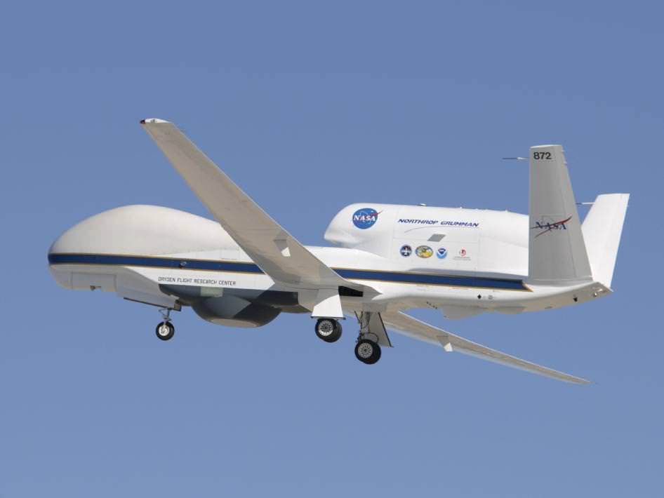
A member of NASA's Global Hawk fleet takes to the air. Credit: NASA/Armstrong Spaceflight Research Center.
What’s in the cards weather-wise for the 2014 Atlantic hurricane season? Although the start of astronomical summer for the northern hemisphere is still over a week away on June 21st, meteorological summer has already begun and with it, hurricane season, which runs from June 1st to November 30th.
This year, NASA is deploying its latest weapons in its hurricane-hunting arsenal to study tropical storms like never before, including two new Earth observing satellites and two uncrewed Global Hawk aircraft.
The Global Hawk flights are set to begin on August 26th from NASA’s Wallops Flight Facility based along the Virginia coast and run through September 29th. This coincides with the peak of the Atlantic hurricane season, when storm activity should be in full swing. The campaign is part of NASA’s airborne Hurricane and Severe Storm Sentinel mission, also known as HS3.
“This year, we’re going full-force into tropical cyclone research,” stated HS3 mission principal investigator Scott Braun in a recent press release from NASA’s Goddard Space Flight center headquartered at Greenbelt, Maryland. “We’ll have two Global Hawks equipped with six instruments. The new NASA-JAXA Global Precipitation Measurement (GPM) Core Observatory will be providing much higher quality data than previously available on rain structure in tropical cyclones in all ocean basins. The surface-wind monitoring ISS-RapidScat instrument to be launched to the International Space Station this season will provide valuable information on surface winds and storms.”
One of the key mysteries that the HS3 program is targeting is the role that a dry hot air phenomenon known as the Saharan Air Layer or SAL plays in hurricane formation and subsequent intensification. Some studies suggest the SAL feeds and triggers hurricane formation off of the north African coast —a mainstream view held by many meteorologists — while other studies imply that it may actually suppress it. HS3 will also give researchers the enhanced capability to monitor and track the formation of thunderstorms near the core of hurricanes and tropical storms and follow their progression.
To accomplish this, the HS3 Global Hawk aircraft will deploy devices that measure humidity, temperature and wind speeds known as dropsondes. All of the dropsondes to be deployed by NASA in the 2014 season are managed by the National Oceanic and Atmospheric Administration.
Global Hawk aircraft are ideal for hurricane tracking and hunting because they can stay aloft for up to 26 hours and fly at altitudes of over 18,000 metres. HS3 mission control for the Global Hawks is based out of NASA’s Wallops Flight Facility.
The first Global Hawk will provide data on the storm’s environment. The gear it uses to accomplish this will include the Cloud Physics Lidar (CPL), the Advanced Vertical Atmospheric Profiling System (AVAPS), and the Scanning High-resolution Interferometer Sounder (S-HIS).
Global Hawk number two will analyze the core storm regions to gauge temperature, humidity, surface winds and precipitation. It will use an array of instruments to accomplish this, including the High-Altitude Monolithic Microwave Integrated Circuit Sounding Radiometer (HAMSR), the Hurricane Imaging Radiometer (HIRAD), and Doppler Radar.
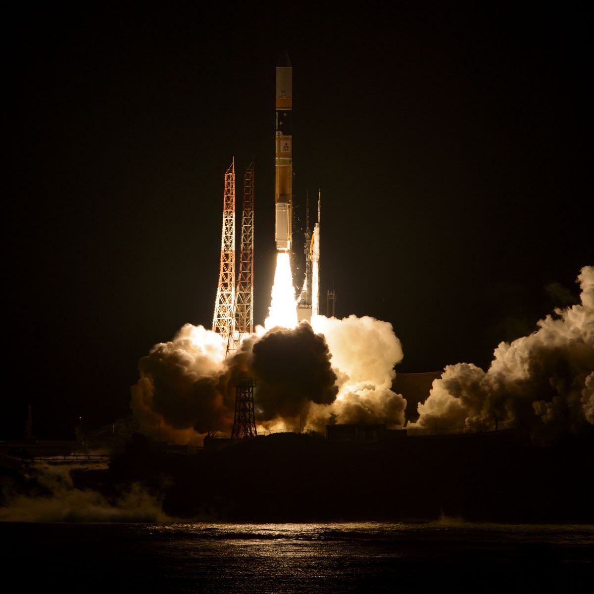
The dramatic night launch of the GPM satellite from Tanegashima, Japan. Credit: NASA/JAXA
In orbit, the Global Precipitation Mission (GPM) will continue with the legacy of the Tropical Rainfall Measuring Mission (TRMM) and follow hurricanes through all phases of formation and decay. A joint NASA/JAXA mission, GPM was launched atop an H-IIA rocket earlier this year on February 27th from Tanegashima Space Center located on the southern tip of Kyushu Island in Japan. Of particular interest to GPM researchers is the formation of deep thunderstorms known as hot towers near the hurricane eyewall. GPM is located in an 65° degree inclination in low Earth orbit and will be able to track hurricanes and study hot tower formation as they move out of the tropics.
Newsflash- no sooner than we finished this article than we noticed that a rocket booster associated with the GPM launch is set to reenter soon on June 17th.
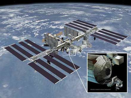
A diagram of RapidScat’s future home on the ISS. Credit: NASA/JPL-Caltech/Johnson Spaceflight Center.
And finally, RapidScat is set to head to the International Space Station later this year. Set to be mounted on the exterior of the Columbus module of the ISS, RapidScat will be an invaluable tool for monitoring ocean surface winds and is a cost effective replacement for the QuickScat satellite that ceased operation in 2009. RapidScat is set to launch on a SpaceX Falcon-9 rocket as part of the CRS-4 Dragon resupply mission slated for sometime this August.
These assets will give NASA the ability to study hurricanes that form during the 2014 season like never before. And speaking of the ISS, the live camera that now broadcasts HD images 24 hours a day will make for some interesting views of hurricanes online from space.
And what’s on tap for the 2014 Atlantic season? Well, forecast models out of Colorado State University suggest that an anomalous cooling early on in the Atlantic will lead to fewer than usual named storms, with perhaps only 9, as opposed to the usual average number of 12. Of these, perhaps 1-2 will reach category 3 or higher, as opposed to the average number of 3. A leading factor in this weakened trend is the possibility of a moderate to strong El Nino event earlier this year. Keep in mind through, that it only takes one destructive hurricane to wreak havoc, and these still can and do occur, even on off years.
Whatever the case, NASA and the NOAA will have all their tools at their disposal ready to study these powerful storms as the season rolls on.
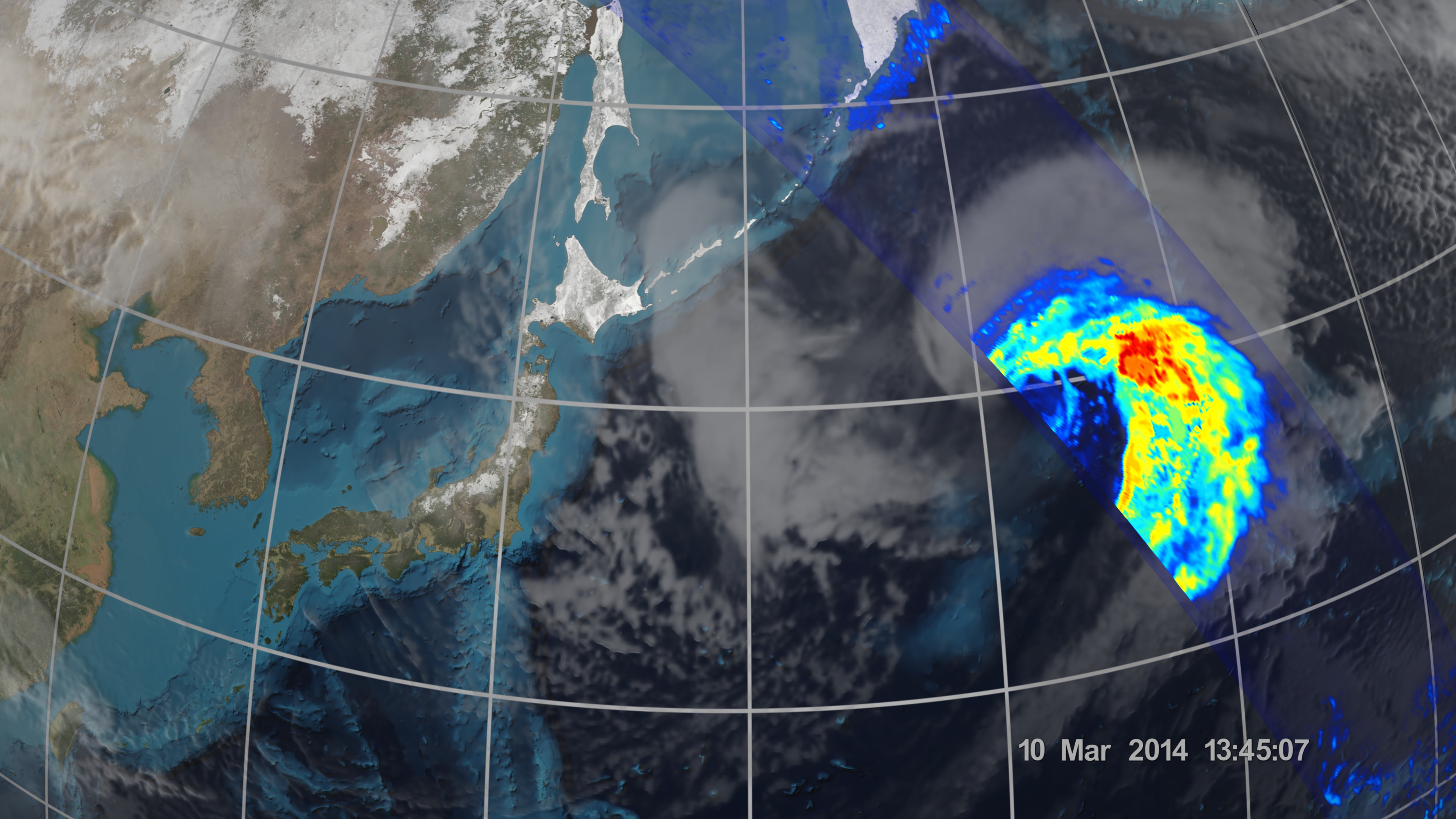
An extra-tropical cyclone seen off the coast of Japan, March 10, 2014, by the GPM Microwave Imager. The colors show the rain rate: red areas indicate heavy rainfall, while yellow and blue indicate less intense rainfall. The upper left blue areas indicate falling snow. Credit: NASA/JAXA
KENNEDY SPACE CENTER, FL – Weather researchers worldwide now have the ability to capture unprecedented three-dimensional images and detailed rainfall measurements of cyclones, hurricanes and other storms from space on a global basis thanks to the newest Earth observing weather satellite – jointly developed by the US and Japan.
NASA and the Japan Aerospace Exploration Agency (JAXA) have now released the first images captured by their Global Precipitation Measurement (GPM) Core Observatory satellite.
GPM soared to space on Feb. 27, exactly one month ago, during a spectacular night launch from the Japanese spaceport at the Tanegashima Space Center on Tanegashima Island off southern Japan.
The newly released series of images show precipitation falling inside a vast extra-tropical cyclone cascading over a vast swath of the northwest Pacific Ocean, approximately 1,000 miles off the coast of eastern Japan.
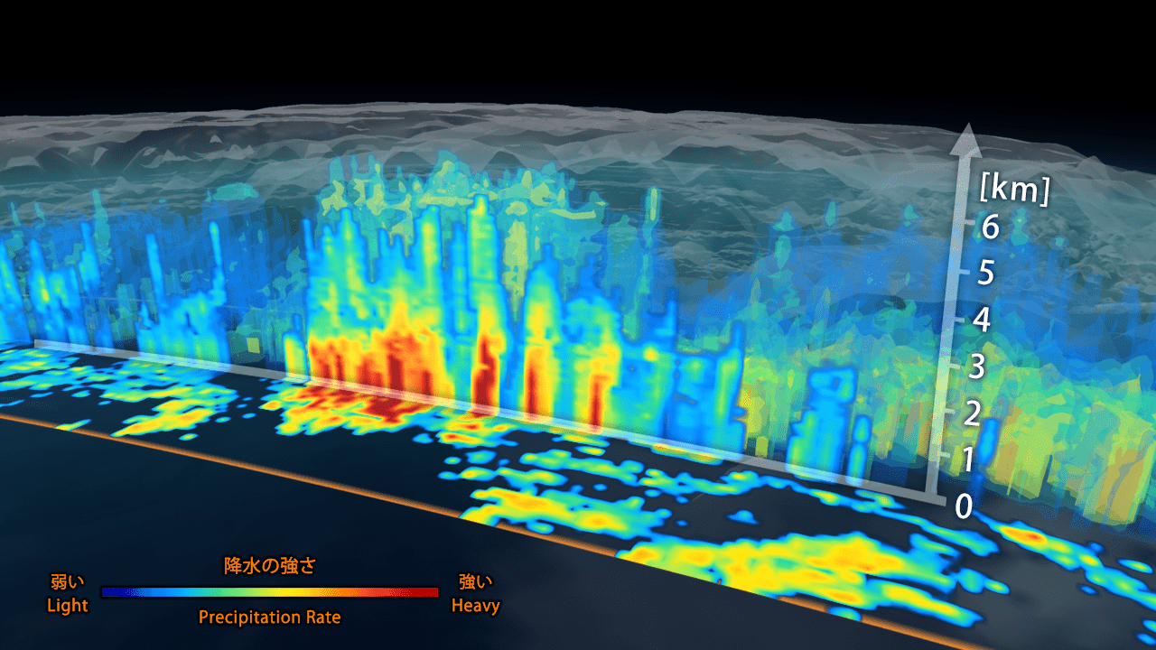
3D view inside an extra-tropical cyclone observed off the coast of Japan, March 10, 2014, by GPM’s Dual-frequency Precipitation Radar. The vertical cross-section approx. 4.4 mi (7 km) high show rain rates: red areas indicate heavy rainfall while yellow and blue indicate less intense rainfall. Credit: JAXA/NASA
“It was really exciting to see this high-quality GPM data for the first time,” said GPM project scientist Gail Skofronick-Jackson at NASA’s Goddard Spaceflight Center in Greenbelt, Md., in a NASA statement.
“I knew we had entered a new era in measuring precipitation from space. We now can measure global precipitation of all types, from light drizzle to heavy downpours to falling snow.”
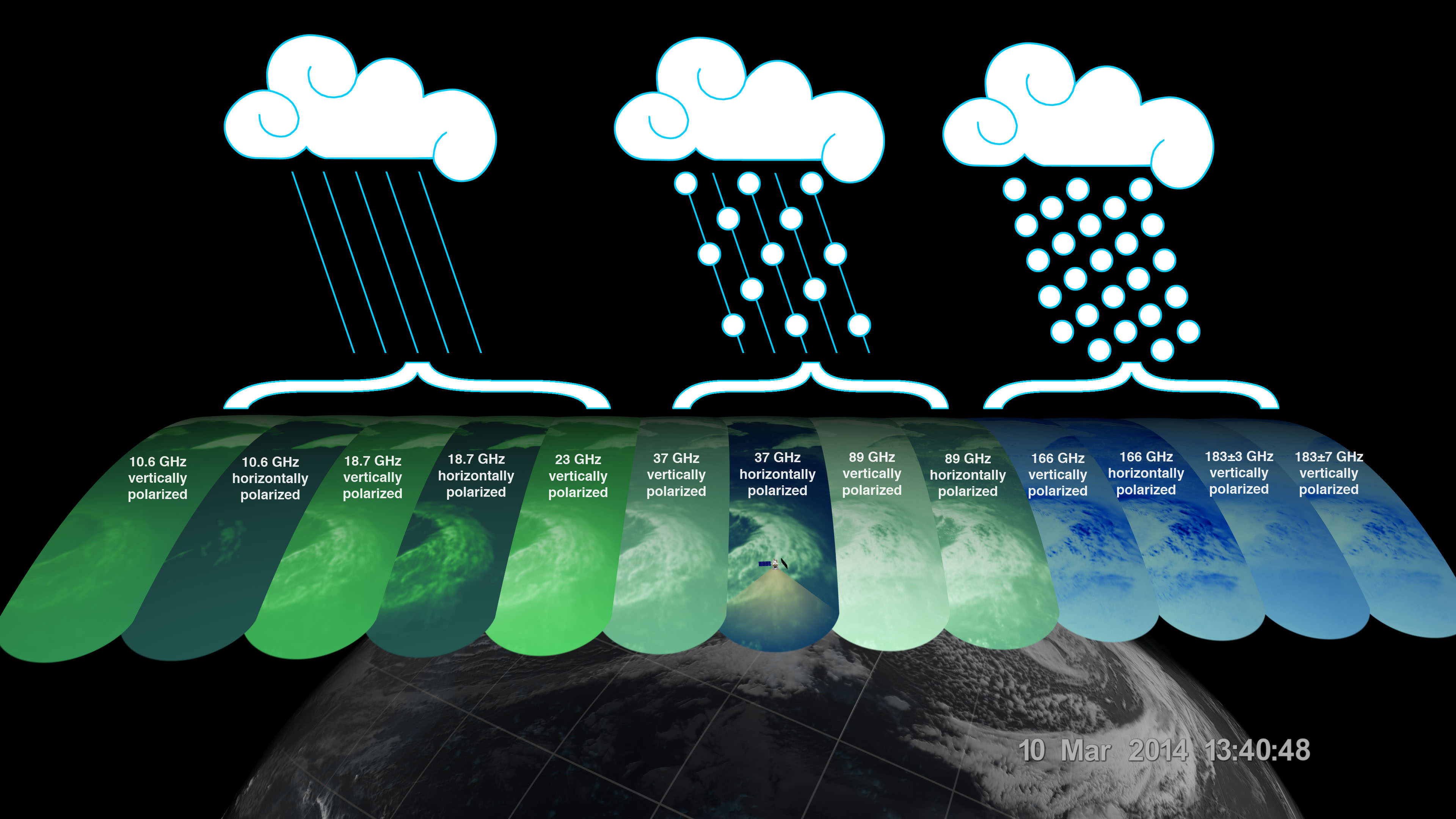
The imagery was derived from measurements gathered by GPM’s two advanced instruments: JAXA’s high resolution dual-frequency precipitation (DPR) radar instrument (Ku and Ka band), which imaged a three-dimensional cross-section of the storm, and the GPM microwave imager (GMI) built by Ball Aerospace in the US which observed precipitation across a broad swath.
“The GMI instrument has 13 channels that measure natural energy radiated by Earth’s surface and also by precipitation itself. Liquid raindrops and ice particles affect the microwave energy differently, so each channel is sensitive to a different precipitation type,” according to a NASA statement.
On March 10, 2014 the Global Precipitation Measurement (GPM) Core Observatory passed over an extra-tropical cyclone about 1,055 miles (1,700 km) east of Japan’s Honshu Island. Formed when a cold air mass wrapped around a warm air mass near Okinawa on March 8, it moved NE drawing cold air over Japan before weakening over the North Pacific. Credit: NASA/JAXA
The 3850 kilogram GPM observatory is the first satellite designed to measure light rainfall and snow from space, in addition to heavy tropical rainfall.
The data were released following check out and activation of the satellites pair of instruments.
“GPM’s precipitation measurements will look like a CAT scan,” Dr. Dalia Kirschbaum, GPM research scientist, told me during a prelaunch interview with the GPM satellite in the cleanroom at NASA’s Goddard Space Flight Center in Greenbelt, Md.
“The radar can scan through clouds to create a three dimensional view of a clouds structure and evolution.”
The $933 Million GPM observatory will provide high resolution global measurements of rain and snow every 3 hours. It is a joint venture between NASA and JAXA.
It will collect a treasure trove of data enabling the most comprehensive measurements ever of global precipitation – and across a wide swath of the planet where virtually all of humanity lives from 65 N to 65 S latitudes.
The GMI instrument has 13 channels, each sensitive to different types of precipitation. Channels for heavy rain, mixed rain and snow, and snowfall are displayed of the extra-tropical cyclone observed March 10, off the coast of Japan. Multiple channels capture the full range of precipitation. Credit: NASA/JAXA
GPM orbits at an altitude of 253 miles (407 kilometers) above Earth – quite similar to the International Space Station (ISS).
GPM is the lead observatory of a constellation of nine highly advanced Earth orbiting weather research satellites contributed by the US, Japan, Europe and India.
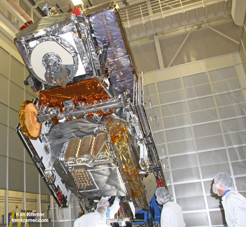
NASA’s next generation Global Precipitation Measurement (GPM) observatory inside the clean room at NASA Goddard Space Flight Center, MD. Technicians at work on final processing during exclusive up-close inspection tour by Universe Today. GPM launched on February 27, 2014 and will provide global measurements of rain and snow every 3 hours. Credit: Ken Kremer/kenkremer.com
Stay tuned here for Ken’s continuing GPM, Curiosity, Opportunity, Chang’e-3, SpaceX, Orbital Sciences, LADEE, MAVEN, MOM, Mars and more planetary and human spaceflight news.
Learn more at Ken’s upcoming presentations at the NEAF convention on April 12/13 and at Washington Crossing State Park, NJ on April 6. Also at the Quality Inn Kennedy Space Center, Titusville, FL, March 29.