Opportunity Begins Standing Up

Image credit: NASA/JPL
NASA’s Opportunity rover has untucked its front wheels and latched its suspension system in place, key steps in preparing to drive off its lander and onto martian soil.

Overnight tonight, mission controllers at NASA’s Jet Propulsion Laboratory, Pasadena, Calif., plan to try tilting the lander platform down in the front by pressing the rear petal downward to raise the back.

“What we want to do is lower the front edge by about 5 degrees,” said JPL’s Dr. Rick Welch, activity lead for preparing the rover for roll-off. Plans call for driving off straight ahead, possibly as early as overnight Sunday-Monday, if all goes well.

Meanwhile, halfway around Mars, Opportunity’s twin, Spirit, continues on the mend from a computer memory problem that struck it a week ago. “Right now we’re working to get complete control of the vehicle, and we’re still not quite there,” said JPL’s Jennifer Trosper, mission manager. “If we’re on the right track, we hope to be back doing some science by early next week. If we’re not on the right track, it could take longer than that.”

Opportunity’s infrared sensing instrument, the miniature thermal emission spectrometer, passed a health check last night. Scientists plan to begin using it tonight. The instrument detects the composition of rocks and soils from a distance. That information will help scientists decide what targets to approach after Opportunity drives off the lander.

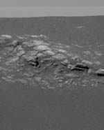
Scientists and rover engineers are already discussing which specific rocks within an outcropping near the lander will make the best targets, said Dr. Jim Bell of Cornell University, Ithaca, N.Y., lead scientist for the panoramic cameras on Opportunity and Spirit. Details of the outcrop can be seen in a new a color-picture mosaic Bell presented, the first portion of a full-circle panorama that has been taken and partially transmitted.

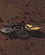
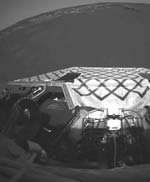
Other new images show how Opportunity’s airbags left detailed impressions in the fine-textured soil as the spacecraft was rolling to a stop in the small crater where it now sits. “These marks are telling us about the physical properties of the material,” Bell said.

Some scientists believe that dark colored granules covering most of the crater’s surface were pressed down into an underlying layer of powdery, lighter red material when the airbags hit. Others hold to a theory that the dark granules are agglomerations that crumble into the finer, lighter material when disturbed. After roll-off, soil near the lander will be the rover’s first target for close-up examination with a microscope and two tools for detecting the composition of the target. The soil at Opportunity’s landing site appears to have different properties than the soil at Spirit’s landing site, Bell said.

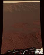
Opportunity has already validated predictions about the landing site made on the basis of images and measurements taken by spacecraft orbiting Mars, said JPL’s Dr. Matt Golombek, a member of the rover science team and co-chair of a steering committee that evaluated potential landing sites for the rovers. The predictions included that the region of Meridiani Planum where Opportunity landed would be safe for landing, would be safe for rover driving, would have very few rocks and would look unlike any place previously seen on Mars.

“This bodes well for our ability to use remote sensing data in the future for picking landing sites,” Golombek said.

Engineers have been able to confirm a diagnosis that an unplanned drawdown of battery power each night on Opportunity is due to a heater on the rover’s robotic arm. A switch designed to overrule the heater’s thermostatic control has not been working. “In the near term, it’s not providing any operational constraints,” Welch said.

JPL, a division of the California Institute of Technology in Pasadena, manages the Mars Exploration Rover project for NASA’s Office of Space Science, Washington, D.C. Images and additional information about the project are available from JPL at http://marsrovers.jpl.nasa.gov and from Cornell University at http://athena.cornell.edu.

Original Source: NASA/JPL News Release

Opportunity Landing Site Named for Challenger Crew

NASA announced plans to name the landing site of the Mars Opportunity rover in honor of the Space Shuttle Challenger’s final crew. The area in the vast flatland called Meridiani Planum, where Opportunity landed this weekend, will be called the Challenger Memorial Station.

The seven-member crew of Space Shuttle Challenger was lost when the orbiter suffered an in-flight breakup during launch Jan. 28, 1986, 18 years ago today.

NASA selected Meridiani Planum because of extensive deposits of a mineral called crystalline hematite, which usually forms in the presence of liquid water. Scientists had hoped for a specific landing site where they could examine both the surface layer that’s rich in hematite and an underlying geological feature of light-colored layered rock. The small crater in which Opportunity alighted appears to have exposures of both, with soil that could be the hematite unit and an exposed outcropping of the lighter rock layer.

Challenger’s 10th flight was to have been a six-day mission dedicated to research and education, as well as the deployment of the TDRS-B communications satellite.

Challenger’s commander was Francis R. Scobee and the mission pilot was Michael J. Smith. Mission specialists included Judith A. Resnik, Ellison S. Onizuka and Ronald E. McNair. The mission also carried two payload specialists, Gregory B. Jarvis and Sharon Christa McAuliffe, who was the agency’s first teacher in space.

Opportunity successfully landed on Mars Jan. 25. It will spend the next three months exploring the region surrounding what is now known as Challenger Memorial Station to determine if Mars was ever watery and suitable to sustain life.

Opportunity?s twin, Spirit, is trailblazing a similar path on the other side of the planet, in a Connecticut-sized feature called Gusev Crater.

A composite image depicting the location of the Challenger Memorial Station can be found on the Web at:

http://www.jpl.nasa.gov/mer2004/rover-images/jan-28-2004/captions/image-1.html

NASA’s Jet Propulsion Laboratory (JPL), a division of the California Institute of Technology, Pasadena, manages the Mars Exploration Rover project for NASA’s Office of Space Science in Washington.

Additional information about the project is available from NASA, JPL and Cornell University, Ithaca, N.Y., on the Internet at: http://www.nasa.gov/

Martian Terrain Named for Lost Apollo Astronauts

Image credit: NASA
NASA memorialized the Apollo 1 crew — Gus Grissom, Ed White and Roger Chaffee — by dedicating the hills surrounding the Mars Exploration Rover Spirit’s landing site to the astronauts. The crew of Apollo 1 perished in flash fire during a launch pad test of their Apollo spacecraft at Kennedy Space Center, Fla., 37 years ago today.

“Through recorded history explorers have had both the honor and responsibility of naming significant landmarks,” said NASA administrator Sean O’Keefe. “Gus, Ed and Roger’s contributions, as much as their sacrifice, helped make our giant leap for mankind possible. Today, as America strides towards our next giant leap, NASA and the Mars Exploration Rover team created a fitting tribute to these brave explorers and their legacy.”

Newly christened “Grissom Hill” is located 7.5 kilometers (4.7 miles) to the southwest of Spirit’s position. “White Hill” is 11.2 kilometers (7 miles) northwest of its position and “Chaffee Hill” is 14.3 kilometers (8.9 miles) south-southwest of rover’s position.

Lt. Colonel Virgil I. “Gus” Grissom was a U.S. Air Force test pilot when he was selected in 1959 as one of NASA’s Original Seven Mercury Astronauts. On July 21, 1961, Grissom became the second American and third human in space when he piloted Liberty Bell 7 on a 15 minute sub-orbital flight. On March 23, 1965 he became the first human to make the voyage to space twice when he commanded the first manned flight of the Gemini space program, Gemini 3. Selected as commander of the first manned Apollo mission, Grissom perished along with White and Chaffee in the Apollo 1 fire. He is buried at Arlington National Cemetery, Va.

Captain Edward White was a US Air Force test pilot when selected in 1962 as a member of the “Next Nine,” NASA’s second astronaut selection. On June 3, 1965, White became the first American to walk in space during the flight of Gemini 4. Selected as senior pilot for the first manned Apollo mission, White perished along with Grissom and Chaffee in the Apollo 1 fire. He is buried at his alma mater, the United States Military Academy, West Point, N.Y.

Selected in 1963 as a member of NASA’s third astronaut class, U.S. Navy Lieutenant Commander Roger Chaffee worked as a Gemini capsule communicator. He also researched flight control communications systems, instrumentation systems, and attitude and translation control systems for the Apollo Branch of the Astronaut office. On March 21, 1966, he was selected as pilot for the first 3-man Apollo flight. He is buried at Arlington National Cemetery, Va.

Images of the Grissom, White and Chaffee Hills can be found at: http://www.jpl.nasa.gov/mer2004/rover-images/jan-27-2004/captions/image-1.html

The Jet Propulsion Laboratory, Pasadena, Calif., manages the Mars Exploration Rover project for NASA’s Office of Space Science, Washington, D.C. JPL is a division of the California Institute of Technology, also in Pasadena. Additional information about the project is available from JPL at http://marsrovers.jpl.nasa.gov and from Cornell University, Ithaca, N.Y., at http://athena.cornell.edu.

Original Source: NASA/JPL News Release

Volcanoes Would Be Good Future Targets

Image credit: NASA/JPL
The current generation of Mars missions have adopted the theme, “Follow the Water”, as a quest to understand the complex geological history of a planet that may have had significant reserves once. For that much warmer and wetter Mars, this motto also requires other ingredients for microbial life, including primordial “fire” in the form of biological temperature ranges.

The global picture of Mars is sometimes compared terrestrially to Antarctic dry regions, only colder. The surface temperature averages -64 F (-53 C), but varies between 200 below zero during polar nights to 80 F (27 C) at midday peaks near the equator. Such temperature extremes suggest that to realize a locally warmer Mars today may require extra heat, such as near a geothermal source.

To consider such interesting places where martian fire might work with other primordial elements like soil, wind and water to give unique science opportunities, Astrobiology Magazine had the chance to talk with Tracy Gregg, Ph.D., assistant professor of geology at the University of Buffalo and chair of the Planetary Geology Division of the Geological Society of America.

Astrobiology Magazine (AM): Given the Pathfinder and Spirit successes with airbag landings, does this descent method make scientists interested in going to places more challenging, like near volcanoes?

Dr. Tracy Gregg (TG): With the success of Spirit, I feel so much more confident about future Mars landers. The airbags seem to be able to withstand quite a bit of trauma. If both of these [Opportunity and Spirit] landers survive with airbag technology, then it blows the doors wide open for future Mars landing sites with far more interesting terrain.

A landing site near a volcano might be possible, now that the airbag technology has worked so wonderfully.

AM: Isn’t Spirit’s landing site at Gusev crater southeast about 120 miles from Apollinaris Patera, and so would that interest include taking a trip back to the Gusev region?

TG: I’d like to see us land ON a volcano. Right on the flanks.

AM: As a geologist, is there interest in the evidence for layering at Meridiani for the Opportunity mission to explore? Would that be sediment or volcanic layering?

TG: Probably some of both. There is a high possibility that we will get to see layers of ancient rock, deposited when Mars was warm and wet and could have supported life. Evidence of river channels, which we expect to see at Sinus Meridiani, could be remnants of that early, warm history. Those layers could be lava flows. Often the best place to look for evidence of life on any planet is near volcanoes.

That may sound counterintuitive, but think about Yellowstone National Park, which really is nothing but a huge volcano. Even when the weather in Wyoming is 20 below zero, all the geysers, which are fed by volcanic heat, are swarming with bacteria and all kinds of happy little things cruising around in the water. So, since we think that the necessary ingredients for life on earth were water and heat, we are looking for the same things on Mars, and while we definitely have evidence of water there, we still are looking for a source of heat.

AM: On the surface, what would exposed hematite look like in pictures? Matt Golombek, the project scientist for Pathfinder and a current rover science team member, indicated that Meridiani will look totally different from Gusev, with a grey, basaltic landscape. Are there any places on Earth that might give a tie-point to anticipating what the images will show?

TG: It depends what “pictures” you’re talking about and how fine-grained the hematite is. Hematite, if sufficiently abundant on the surface, may make the surface black and sparkly to a human eye. But it’s more likely to be observed using the special tools Spirit is equipped with–microscopic imagers and a spectrometer.

AM: Where are large hematite deposits found on Earth, and is their history terrestrially always tied to water?

TG: I’m not sure off the top of my head where they are globally–there are some huge deposits in the north-central US (think about the Minnestota and Michigan mining histories). Certainly on Earth they only form in the presence of large volumes of water.

AM: Is it correct to say that there are no active surface volcanoes on Mars today?

TG: If you’d asked me that 10 years ago–or even 5–I might’ve said yes. Now I’m not so sure.

AM: Do you think there is geological interest in landing in higher latitudes, nearer the martian poles?

TG: YES.

AM: Would the rocks be less interesting at higher latitudes but the seasons more interesting because of the presence of frost and the annual melting exchanges that happen between ice and dry-ice subliming at different rates?

TG: Higher latitudes are interesting to me because that’s where the large volcanoes are, and there’s more opportunities for magma/water interactions. Those interactions are probably extremely important for the origin and evolution of life.

AM: Are there alternatives to airbags and rocket landings?

TG: Sure, but so far airbags seem to work the best.

AM: Do you have an opinion about a sample return mission to Mars, using the Stardust mission profile–in which a projectile is dropped on the surface and that kicked-up dust is then flown through with a capture device from orbit?

TG: I’m a volcanologist who studies lava flows. I’m most interested in hard lava, or indurated volcanic ash. I’d much rather see a rock hammer go to Mars than a dust bin. However, any sample return would reveal a phenomenal amount of information about the surface processes operating on Mars.

I’d embrace any sample over none…

AM: If you were to guess at where the best chance to find active volcanology today on Mars might be, can you describe that spot briefly? For instance would this be a shield volcano visible on the surface, or some kind of subterranean magma chamber that is not exposed permanently?

TG: OK, I have to be a little picky here and supply some definitions before I can answer your question. As a planetary volcanologist, I have some pretty specific meanings in mind for certain terms, and I want to be sure you understand where I’m coming from.

Typically, a volcano on Earth is considered to be “active” if it has erupted sometime within the past 10 thousand years. By that definition, a “subterranean magma chamber” in and of itself would not constitute “active” volcanism, if all the activity is beneath the surface.

Can we use those same definitions on Mars to define “active volcanism?” Sure. But should we? I don’t think so.

The 10,000 year cutoff was chosen for Earth both for scientific and practical reasons. Scientifically, we know that it isn’t terribly likely for a given volcanic vent to spout off again if it hasn’t done anything in about 10,000 years. Practically, that’s about the time that the last Ice Age ended, leaving behind remarkable geologic signs–so all we have to do is decide if the volcanic activity is older or younger than the most recent glacial activity.

That’s not something we can do on Mars.

That said, where would I look for recent volcanic activity? Depends on how you want to define it on Mars. I strongly suspect there are still molten (or at least mushy) magma bodies beneath the huge Tharsis volcanoes, and beneath Elysium Mons.

But the youngest surficial activity discovered to date (and it’s probably 1 million years old, which would be considered quite young, and possibly “active” on Mars) is in a region that contains no large volcanic structures of any kind. Instead, there are cracks in the ground, and a few low-lying volcanoes that can’t even be seen except in the high-resolution topography (they are too subtle for imagery to reveal). This area is called Cerberus Fossae.

This tells me that “active” volcanism, if it exists in the terrestrial sense, is probably in the Northern Hemisphere, where the crust is thin, and possibly close to Tharsis or Elysium. But not necessarily.

Original Source: Astrobiology Magazine

What is that Bedrock?

Image credit: NASA/JPL
The first impression of the Opportunity landing site in color is the light, exposed area about ten meters from the rover’s location inside a crater. The region has by now accumulated a plethora of adjectives and names: bizarre, alien, hummocky, layered, crater-rim, outcrop, stratigraphic slice, tabular, segmented, slabby.

But what has scientists most intrigued is that the slabs are bedrock. The literal foundation of Mars is its bedrock. Bedrock is the solid, intact part of the planet’s crust. Whereas in comparison to terrestrial crust, parts of southern Arizona or Louisian may have thousands of feet of unconsolidated surficial material overlying bedrock, the depth to bedrock in a place like Maine ranges from ten to only a few hundred feet. Many of the more spectacular sites in Maine feature rugged bedrock exposed to view. To find bedrock is to know geologically that the history of this location is free from rock and boulder transport, mainly by wind, water, lava and impact debris.

Whatever happened on Mars over billions of years, that hummocky slab bears its records.

Steve Squyres, principal investigator for rover science, described the five exploration stages likely to follow in the next few weeks.

While still perched on its base petal, the rover cameras will first snap panoramic color images in octets of 45 degrees each, until a full picture shows the surroundings. Without driving, the rover’s pancam can probably get a good idea of the soil and rock surface composition, using its infrared capabilities to image circular aspects of the horizon in heat-sensitive colors. Called the mini-TES instrument, the main tool for this measures thermal emissions.

The mobile laboratory will then drive off its station, maneuvering down a ramp and 40 cm drop (slightly more than a foot). The rover will look at the fine soil nearby, in hopes of finding out why this particular region is rare on Mars in being rich with iron-oxides. The surface soil’s top layer is grey, much more grey than anything seen on Mars before. On the surface, Meridiani is the darkest color yet visited.

But this dark layer gave way when the airbags were retracted revealing a deep maroon layer underneath. When summarizing the science activities by discipline, Steve Squyres noted that most of the group members–atmospherics, long-term planning, mineralogy, geology–are not fully engaged until the instrument suite is checked out and deployed on the surface. But “the soil physical properties group is having the most fun” speculating about how this maroon and grey landform came to be. Squyres described the competing theories as either “we have soil with two distinct components of coarse, grey grains on top of fine red soil–or we have aggregates that are grey but when squished, the red comes out.

When certified to drive, the rover will explore the bedrock outcrop, while looking carefully for any layers or stratigraphic history. Since the rover is inside a crater (20 meters wide, 2-3 meters deep), the next step is probably to climb out. Depending on the soil texture, the rover is probably able to climb an embankment at a relatively steep 15 to 20 degree angle. As Squyres remarked: “We traveled 200 milllon miles or so to land in a crater. It was a hole-in-one.”

Since orbital images of the landing area shows three distinct color gradations, a first guess is that once outside this crater, the view will suddenly change to what is expected to be lighter colored soil. The brightest areas seen orbitally are the crater rims, followed by the flat plains, then the darkest interior to the craters, where Opportunity now is snapping charcoal-grey scenery. Since the horizon’s range is mainly restricted to 10 meters for now, once outside this crater the startling picture of a dark grey Mars will likely change yet again.

This second soil unit is brighter, perhaps from wind not apparent inside the craters, and will be looked at closely using the same diagnostics used on the crater floor and outcrop.

Squyres said the science team then looks to “head for the big one”–a 150 meter wide crater, probably 10-15 meters deep at least and about half-a-mile away. The bright rim of that crater may well be another remnant of bedrock or something different altogether.

How that driving spree will go looks promising so far. As pancam science lead, Jim Bell, described, where they can barely glimpse the horizon, it is flat and free of large rocks for five to six kilometers. This kind of “flat-out” driving terrain makes for fewer maneuvers to go the distance.

Once they survey the real Meridiani plain outside their crater, they will gain some higher ground–about the height of an average person of five to six feet climbing out of a hole of similar depth.

As JPL Center Director, Charles Elachi, pointed out on the night when Spirit first landed, the unique part of these missions is their multiplicity–not only two views of opposite sides of the planet, but also local mobility in which each science day that involves driving is comparable to a new landing. In 1976 Viking could only reach out and scratch the soil surface. The tiny Pathfinder rover could move between larger boulders, but had limited range. The Mars Exploration Rovers, with their mobile geology toolkit, are designed for the road.

Original Source: Astrobiology Magazine

Opportunity’s Hardware is Working Properly

Image credit: NASA/JPL
During the second day on Mars for NASA’s Opportunity rover, key science instruments passed health tests and the rover made important steps in communicating directly with Earth.

Halfway around the planet, during its 22nd day on Mars, NASA’s Spirit obeyed commands for transmitting information that is helping engineers set a strategy for fixing problems with the rover’s computer memory.

On Earth this morning, scientists marveled at a high-resolution color “postcard” of Opportunity’s surroundings. The mosaic of 24 frames from the panoramic camera shows details from the edge of the lander to the distant horizon beyond the rim of the rover’s small home crater.

“We’re looking out across a pretty spectacular landscape,” said Dr. Jim Bell of Cornell University, Ithaca, N.Y., lead scientist for the panoramic cameras on Spirit and Opportunity. “It’s going to be a wonderful area for geologists to explore with the rover.”

The color view shows dark soil that brightened where it was compacted by the rolling spacecraft, and an outcropping of bedrock on the inside slope of the 20-meter (66-foot) crater in which the rover sits. Opportunity will be commanded to finish taking a 360- degree color panorama of the site during its third Mars day, which began at 12:01 p.m. PST today.

Another major step planned for Opportunity’s third day is to begin using its high-gain antenna for communicating directly with Earth at a high data rate, said Jackie Lyra of NASA’s Jet Propulsion Laboratory, Pasadena, Calif., activity lead for this rover event. In preparation for this transition, Opportunity found the Sun with its panoramic camera yesterday. Once oriented by knowing the position of the Sun, it can calculate how to point its high-gain antenna toward Earth.

“We’re making steady progress in our effort to get the wheels of the rover dirty,” said Mission Manager Jim Erickson of JPL. Still the earliest scenario for the rover to drive off its lander platform is more than a week away.

Opportunity has tested the three scientific sensing instruments on its robotic arm that will be used for up-close examination of rocks and soil: the microscopic imager, the alpha particle X-ray spectrometer for determining what elements are present, and a Moessbauer spectrometer for identifying iron-containing minerals. “I’m pleased to report that all are in perfect health,” said Dr. Steve Squyres of Cornell University, Ithaca, N.Y., principal investigator for the science instruments on the rovers.

Squyres had been especially concerned about the Moessbauer spectrometer because tests conducted while the spacecraft was on its way to Mars showed that an internal calibration system was not working as intended. However, after the rover landed on Mars, the instrument is functioning normally again. The Moessbauer spectrometer’s function for identifying iron-bearing minerals will be important in the scientific goal of determining the origin of iron-bearing hematite deposits in the Meridiani Planum region selected as Opportunity’s landing site.

“We have a perfectly functioning Moessbauer spectrometer, and given that we are now perched atop the hematite capital of the Solar System, that’s a good thing,” Squyres said.

Restoration efforts continue making progress on Spirit. “We have a patient in rehab, and we’re nursing her back to health,” said JPL’s Jennifer Trosper, mission manager.

Engineers found a way to stop Spirit’s computer from resetting itself about once an hour by putting the spacecraft into a mode that avoids use of flash memory. Flash memory is a type common in many electronic products, such as digital cameras, for storing information even when the power is off. The rover also has random- access memory, which cannot hold information during the rover’s overnight sleep. One of the next steps planned is to erase from flash memory the files stored there from the spacecraft’s cruise to Mars from Earth. That is intended to lessen the task of managing the flash memory files.

The rovers’ main task is to explore their landing sites during coming months for evidence in the rocks and soil about whether the sites’ past environments were ever watery and possibly suitable for sustaining life.

JPL, a division of the California Institute of Technology in Pasadena, manages the Mars Exploration Rover project for NASA’s Office of Space Science, Washington, D.C. Images and additional information about the project are available from JPL at http://marsrovers.jpl.nasa.gov and from Cornell University, Ithaca, N.Y., at http://athena.cornell.edu.

Original Source: NASA/JPL News Release

Search for Beagle 2 is Winding Down

Image credit: Beagle 2
No contact has been made with the Beagle 2 lander, despite repeated efforts over the last few days to communicate via the Mars Express and Mars Odyssey spacecraft and the Jodrell Bank radio telescope in Cheshire, UK.

At a press briefing in London this afternoon, members of the Beagle 2 team described the latest efforts to contact their missing lander.

“We haven?t found Beagle 2, despite three days of intensive searching,” said Professor Colin Pillinger, lead scientist for Beagle 2. “Under those circumstances, we have to begin to accept that, if Beagle 2 is on the Martian surface, it is not active.

“That isn?t to say that we are going to give up on Beagle. There is one more thing that we can do – however, it is very much a last resort. We will be asking the American Odyssey spacecraft (team) tomorrow whether they will send an embedded command – a hail to Beagle with a command inside it. If it gets through, it will tell Beagle to switch off and reload the software. We are now working on the basis that there is a corrupt system and the only way we might resurrect is to send that command.”

“We can also ask Mars Express to send that command. However, they cannot send it probably until the 2 or 3 February,” he added.

“We?ll move with the next phase in the search for Beagle 2,” said Professor Pillinger. “We have discussed on our side of the house what we intend to do in the future. We are dedicated to trying to refly Beagle 2 in some shape or form, therefore we need to know how far it got because we need know which parts of this mission we don?t have to study in further detail.”

Detailing the efforts to contact Beagle 2 in recent days, Mark Sims, Beagle 2 Mission Manager from the University of Leicester, explained that the lander should have entered an emergency communication mode known as CSM2 no later than 22 January. In this mode, the spacecraft?s receiver is switched on throughout daylight hours on Mars. The only possible explanation that no communication has been established during the last few days is that the lander?s battery is in a low state of charge.

Meanwhile, the academia-industry “Tiger Team” at the National Space Centre in Leicester is beginning to concentrate on detailed analysis of the possible causes for failure of the mission and the lessons that can be learned for future missions.

The analysis of the mission now under way includes an assessment of the landing site ellipse from orbital images, reanalysis of atmospheric conditions during the entry into the Martian atmosphere on 25 December, examination of the separation from Mars Express and of the cruise phase preceding arrival at Mars.

One extremely useful piece of evidence could be provided by an image of the lander. The team is hoping that the High Resolution Stereo Camera on Mars Express or the camera on board Mars Global Surveyor may eventually be able to capture an image that reveals its location on the Martian surface.

Original Source: PPARC News Release

Opportunity is in a Small Crater

Image credit: NASA/JPL
A small impact crater on Mars is the new home for NASA’s Opportunity rover, and a larger crater lies nearby. Scientists value such crater locations as a way to see what’s beneath the surface without needing to dig.

Encouraging developments continued for Opportunity’s twin, Spirit, too. Engineers have determined that Spirit’s flash memory hardware is functional, strengthening a theory that Spirit’s main problem is in software that controls file management of the memory. “I think we’ve got a patient that’s well on the way to recovery,” said Mars Exploration Rover Project Manager Pete Theisinger at NASA’s Jet Propulsion Laboratory, Pasadena, Calif.

Opportunity returned the first pictures of its landing site early today, about four hours after reaching Mars. The pictures indicate that the spacecraft sits in a shallow crater about 20 meters (66 feet) across.

“We have scored a 300-million mile interplanetary hole in one,” said Dr. Steve Squyres of Cornell University, Ithaca, N.Y., principal investigator for the science instruments on both rovers.

NASA selected Opportunity’s general landing area within a region called Meridiani Planum because of extensive deposits of a mineral called crystalline hematite, which usually forms in the presence of liquid water. Scientists had hoped for a specific landing site where they could examine both the surface layer that’s rich in hematite and an underlying geological feature of light-colored layered rock. The small crater appears to have exposures of both, with soil that could be the hematite unit and an exposed outcropping of the lighter rock layer.

“If it got any better, I couldn’t stand it,” said Dr. Doug Ming, rover science team member from NASA Johnson Space Center, Houston. With the instruments on the rover and just the rocks and soil within the small crater, Opportunity should be allow scientists to determine which of several theories about the region’s past environment is right, he said. Those theories include that the hematite may have formed in a long-lasting lake or in a volcanic environment.

An even bigger crater, which could provide access to deeper layers for more clues to the past, lies nearby. Images taken by a camera on the bottom of the lander during Opportunity’s final descent show a crater about 150 meters (about 500 feet) across likely to be within about one kilometer or half mile of the landing site, said Dr. Andrew Johnson of JPL. He is an engineer for the descent imaging system that calculated the spacecraft’s horizontal motion during its final seconds of flight. The system determined that sideways motion was small, so Opportunity’s computer decided not to fire the lateral rockets carried specifically for slowing that motion.

Squyres presented an outline for Opportunity’s potential activities in coming weeks and months. After driving off the lander, the rover will first examine the soil right next to the lander, then drive to the outcrop of layered-looking rocks and spend considerable time examining it. Then the rover may climb out of the small crater, take a look around, and head for the bigger crater.

But first, Opportunity will spend more than a week — perhaps two — getting ready to drive off the lander, if all goes well. Engineering data from Opportunity returned in relays via NASA’s Mars Odyssey orbiter early this morning and at midday indicate the spacecraft is in excellent health, said JPL’s Arthur Amador, mission manager. The rover will try its first direct-to-Earth communications this evening.

The main task for both rovers in coming months is to explore the areas around their landing sites for evidence in rocks and soils about whether those areas ever had environments that were watery and possibly suitable for sustaining life.

JPL, a division of the California Institute of Technology, Pasadena, manages the Mars Exploration Rover project for NASA’s Office of Space Science, Washington, D.C. Additional information about the project is available from JPL at http://marsrovers.jpl.nasa.gov and from Cornell University, Ithaca, N.Y., at http://athena.cornell.edu.

Original Source: NASA/JPL News Release

Engineers Restore Communications With Spirit

Image credit: NASA/JPL
Hours before NASA’s Opportunity rover will reach Mars, engineers have found a way to communicate reliably with its twin, Spirit, and to get Spirit’s computer out of a cycle of rebooting many times a day.

Spirit’s responses to commands sent this morning confirm a theory developed overnight that the problem is related to the rover’s two “flash” memories or software controlling those memories.

“The rover has been upgraded from critical to serious,” said Mars Exploration Rover Project Manager Peter Theisinger at NASA’s Jet Propulsion Laboratory, Pasadena, Calif. Significant work is still ahead for restoring Spirit, he predicted.

Opportunity is on course for landing in the Meridiani Planum region of Mars. The center of an ellipse covering the area where the spacecraft has a 99 percent chance of landing is just 11 kilometers (7 miles) from the target point. That point was selected months ago. Mission managers chose not to use an option for making a final adjustment to the flight path. Previously, the third and fifth out of five scheduled maneuvers were skipped as unnecessary. ” We managed to target Opportunity to the desired atmospheric entry point, which will bring us to the target landing site, in only three maneuvers,” said JPL’s Dr. Louis D’Amario, navigation team chief for the rovers.

Opportunity will reach Mars at 05:05 Sunday, Universal Time (12:05 a.m. Sunday EST or 9:05 p.m. Saturday PST).

From the time Opportunity hits the top of Mars? atmosphere at about 5.4 kilometers per second (12,000 miles per hour) to the time it hits the surface 6 minutes later, then bounces, the rover will be going through the riskiest part of its mission. Based on analysis of Spirit’s descent and on weather reports about the atmosphere above Meridiani Planum, mission controllers have decided to program Opportunity to open its parachute slightly earlier than Spirit did.

Mars is more than 10 percent farther from Earth than it was when Spirit landed. That means radio signals from Opportunity during its descent and after rolling to a stop have a lower chance of being detected on Earth. About four hours after the landing, news from the spacecraft may arrive by relay from NASA’s Mars Odyssey orbiter. However, that will depend on Opportunity finishing critical activities, such as opening the lander petals and unfolding the rover’s solar panels, before Odyssey flies overhead.

Spirit has 256 megabytes of flash memory, a type commonly used on gear such as digital cameras for holding data even when the power is off. Engineers confirmed this morning that Spirit’s recent symptoms are related to the flash memory when they commanded the rover to boot up and utilize its random-access memory instead of flash memory. The rover then obeyed commands about communicating and going into sleep mode. Spirit communicated successfully at 120 bits per second for nearly an hour.

“We have a vehicle that is stable in power and thermal, and we have a working hypothesis we have confirmed,” Theisinger said. By commanding Spirit each morning into a mode that avoids using flash memory, engineers plan to get it to communicate at a higher data rate, to diagnose the root cause of the problem and develop ways to restore as much functioning as possible.

The work on restoring Spirit is not expected to slow the steps in getting Opportunity ready to roll off its lander platform if Opportunity lands safely. For Spirit, those steps took 12 days.

The rovers’ main task is to explore their landing sites for evidence in the rocks and soil about whether the sites’ past environments were ever watery and possibly suitable for sustaining life.

JPL, a division of the California Institute of Technology in Pasadena, manages the Mars Exploration Rover project for NASA’s Office of Space Science, Washington. Images and additional information about the project are available from JPL at http://marsrovers.jpl.nasa.gov and from Cornell University, Ithaca, N.Y., at http://athena.cornell.edu.

Original Source: NASA/JPL News Release

Opportunity Joins Spirit on Mars

Image credit: NASA/JPL

NASA’s Opportunity rover successfully landed on the surface of Mars early Sunday morning, giving the agency two successful landings this month. The spacecraft landed in a region of Mars called Meridiani Planum which is on the opposite side of the planet from Gusev Crater. Initial estimates placed the rover about 24 km down range from the centre of the target area, but well within the regions of hematite which could be an indication of past water. Unlike Spirit, Opportunity landed on its side and righted itself when it opened the petals of its lander. Opportunity’s airbags aren’t blocking the exit ramp, so there won’t be a problem when the rover rolls out onto the Martian surface.

NASA’s second Mars Exploration Rover successfully sent signals to Earth during its bouncy landing and after it came to rest on one of the three side petals of its four-sided lander.

Mission engineers at NASA’s Jet Propulsion Laboratory, Pasadena, Calif., received the first signal from Opportunity on the ground at 9:05 p.m. Pacific Standard Time Saturday via the NASA Deep Space Network, which was listening with antennas in California and Australia.

“We’re on Mars, everybody!” JPL’s Rob Manning, manager for development of the landing system, announced to the cheering flight team.

NASA Administrator Sean O’Keefe said at a subsequent press briefing, “This was a tremendous testament to how NASA, when really focused on an objective, can put every ounce of effort, energy, emotion and talent to an important task. This team is the best in the world, no doubt about it.”

Opportunity landed in a region called Meridiani Planum, halfway around the planet from the Gusev Crater site where its twin rover, Spirit, landed three weeks ago. Earlier today, mission managers reported progress in understanding and dealing with communications and computer problems on Spirit.

“In the last 48 hours, we’ve been on a roller coaster,” said Dr. Ed Weiler, NASA associate administrator for space science. “We resurrected one rover and saw the birth of another.”

JPL’s Pete Theisinger, project manager for the rovers, said, “We are two for two. Here we are tonight with Spirit on a path to recovery and with Opportunity on Mars.”

By initial estimates, Opportunity landed about 24 kilometers (15 miles) down range from the center of the target landing area. That is well within an outcropping of a mineral called gray hematite, which usually forms in the presence of water. “We’re going to have a good place to do science,” said JPL’s Richard Cook, deputy project manager for the rovers.

Once it pushed itself upright by opening the petals of the lander, Opportunity was expected to be facing east.

The main task for both rovers in coming months is to explore the areas around their landing sites for evidence in rocks and soils about whether those areas ever had environments that were watery and possibly suitable for sustaining life.

JPL, a division of the California Institute of Technology in Pasadena, manages the Mars Exploration Rover project for NASA’s Office of Space Science, Washington. Images and additional information about the project are available from JPL at http://marsrovers.jpl.nasa.gov and from Cornell University, Ithaca, N.Y., at http://athena.cornell.edu .

Original Source: NASA/JPL News Release