Second MARSIS Boom Deployed

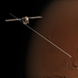
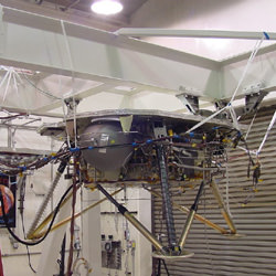
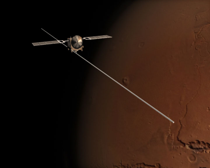
Artist illustration of Mars Express deploying its MARSIS boom. Image credit: ESA. Click to enlarge.
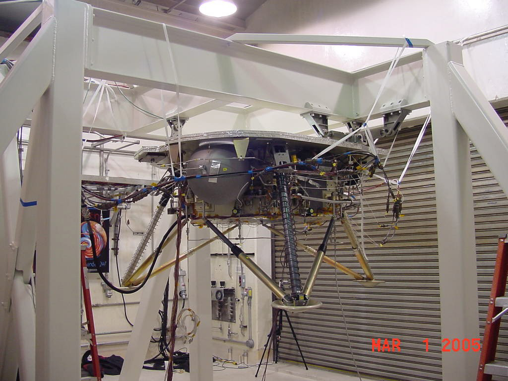
The second 20-metre antenna boom of the MARSIS instrument on board Mars Express was successfully ? and smoothly ? deployed, confirmed today by the ground team at ESA?s European Space Operations Centre.

The command to deploy the second MARSIS boom was given to the spacecraft at 13:30 CEST on 13 June 2005.

Shortly before the deployment started, Mars Express was set into a slow rotation to last 30 minutes during and after the boom extension. This rotation allowed all the boom?s hinges to be properly heated by the Sun.

Just after, an autonomous manoeuvre oriented the spacecraft towards the Sun, to have the spacecraft recharge its batteries and for a further heating of the hinges.

A first positive sign reached ground in the afternoon of 14 June, at 16:20 CEST, when Mars Express was able to properly re-orient itself and point towards Earth to transmit data.

The data received in the following hours confirmed that the initial spacecraft behaviour was consistent with two fully and correctly deployed booms and that the deployment had not induced disturbance frequencies that may have been dangerous for the spacecraft.

A series of tests during the following 48 hours was necessary to verify that the long boom was successfully locked and that the deployment did not affect the integrity of the spacecraft systems.

The complete success of the operation was announced today at 14:00 CEST, when the ground team had completed all tests on the spacecraft systems. This confirmed that the spacecraft is in optimal shape and under control, with the second MARSIS boom straight and locked into the correct position.

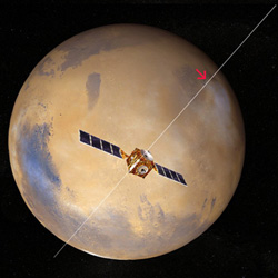
With the two MARSIS 20-metre radar booms fully deployed, Mars Express is already in principle capable of ?looking? beneath the Martian surface, and also studying its ionosphere (the upper atmosphere). The third 7-metre ?monopole? boom, to be deployed perpendicularly to the first two booms, will be used to correct some surface roughness effects on the radio waves emitted by MARSIS and reflected by the surface.

The third boom deployment, not considered critical because of its orientation and shorter length, will take place on 17 June 2005. It will be followed by further tests on the spacecraft and the MARSIS instrument for a few more days.

The radar, with its long booms, will allow Mars Express to continue its search for water on Mars. By night, it will be used to make soundings for water below the surface. By day, it will probe the structure of the ionosphere.

Jean-Jacques Dordain, ESA Director General, said: “This is a great success following some tense moments and careful judgements. The result shows the power of the teamwork between ESA, European industry and ESA’s partners in the scientific community in Europe and elsewhere.”

Original Source: ESA News Release

Mmmm, Food From Mars

Spirulina Gnocchis, a recipe that could be cooked up from food grown in space. Image credit: ESA. Click to enlarge.
‘Martian bread and green tomato jam’, ‘Spirulina gnocchis’ and ‘Potato and tomato mille-feuilles’ are three delicious recipes that two French companies have created for ESA and future space explorers to Mars and other planets.

The challenge for the chefs was to offer astronauts well-flavoured food, made with only a few ingredients that could be grown on Mars. The result was 11 tasty recipes that could be used on future ESA long-duration space missions. ADF ? Alain Ducasse Formation and GEM are the two French companies that produced the recipes, and their mutual experience in creating new products and ?haute cuisine? have led to excellent results.

The menus were all based on nine main ingredients that ESA envisions could be grown in greenhouses of future colonies on Mars or other planets. The nine must comprise at least 40% of the final diet, while the remaining (up to) 60% could be additional vegetables, herbs, oil, butter, salt, pepper, sugar and other seasoning brought from Earth.

“We are aiming initially at producing 40% locally for astronauts’ food on future long-duration space missions, for example to Mars,” says Christophe Lasseur, ESA’s biological life-support coordinator responsible for recycling and production of air, water and food for long-term space missions.

“Why 40%? By growing enough plants to cover around 40% of what we eat, we also get ‘for free’ the oxygen and water needed to live”, explains Lasseur.

The nine basic ingredients that Lasseur plans to grow on other planets are: rice, onions, tomatoes, soya, potatoes, lettuce, spinach, wheat and spirulina ? all common ingredients except the last. Spirulina is a blue-green algae, a very rich source of nutrition with lots of protein (65% by weight), calcium, carbohydrates, lipids and various vitamins that cover essential nutritional needs for energy in extreme environments.

Today all the food for astronauts in space is brought from Earth, but this will not be possible for longer missions. Although still on the drawing board, ESA has already started research to see what could be grown on other planets – and what a self-supporting eco-system might look like on Mars.

“In addition to being healthy and sufficiently nutritious for survival, good food could potentially provide psychological support for the crew, away from Earth for years,” emphasises Lasseur.

ADF chef Armand Arnal, adds: “The main challenge was to create a wide panel of recipes, distinct and full-flavoured, with only nine basic products.”

“Moreover, we had absolute restrictions on using salt, but were allowed to add a bit of sugar and fat, ingredients normally essential to the elaboration of a dish and to highlight its flavours.”

Original Source: ESA News Release

Coprates Chasma on Mars

Perspective view of Coprates Chasma and Catena. Image credit: ESA. Click to enlarge.
This image, taken by the High Resolution Stereo Camera (HRSC) on board ESA?s Mars Express spacecraft, shows Coprates Chasma, a major trough in the Valles Marineris canyon system.

The HRSC obtained this image during orbit 449 with a ground resolution of approximately 48 metres per pixel.

The scene shows the region containing the sections of Coprates Chasma and Coprates Catena, over an area centred at about 13.5? South and 300? East, roughly in the centre of the Valles Marineris canyon system.

The trough of Coprates Chasma appears in the north, and ranges from approximately 60 km to 100 km wide and extends 8-9 km below the surrounding plains.

Coprates Catena lies parallel to Coprates Chasma and can be seen in the south as three troughs, ranging from a few kilometres to 22 km wide and up to 5 km deep. These troughs have been modified by erosion, as indicated by the linear features extending from the upper edge of the trough walls.

In contrast to the relatively sharp appearance of the upper regions of the trough walls, the lower slopes and the floors of the troughs have a softer appearance, which is probably the result of atmospheric dust.

Linear features, prevalent throughout the image and running generally parallel to the major troughs, may be faults.

Scientists are unsure of the mechanism responsible for the creation of the Valles Marineris canyon system. Some suggest that the formation of the Tharsis uplift, located west of the canyon system, caused tension and fracturing of the Martian crust.

Other researchers believe that water may have removed rock material from the subsurface, which caused the surface to collapse. A related theory suggests that large quantities of subsurface ice melted, causing surface collapse. Possibly all of these processes together were active in forming the structure.

Valles Marineris provides scientists with a window into the depths of Mars and enables them to study the complex geological and climatic history of the Red Planet.

By supplying new data for Valles Marineris, including colour and stereo images, the Mars Express HRSC camera aids scientists in this endeavour, ultimately improving our understanding of this fascinating planet.

Original Source: ESA News Release

First Aurora Seen on Mars

Terra Cimmeria region of Mars where the aurora was detected. Image credit: ESA. Click to enlarge.
ESA?s Mars Express spacecraft has for the first time ever detected an aurora on Mars. This aurora is of a type never previously observed in the Solar System.

Observations by the SPICAM instrument (SPectroscopy for the Investigations and the Characteristics of the Atmosphere on Mars) taken on 11 August 2004, revealed light emissions now interpreted as an aurora.

Aurorae are spectacular displays often seen at the highest latitudes on Earth. On our planet, as well as on the giant planets Jupiter, Saturn, Uranus and Neptune, they lie at the foot of the planetary magnetic field lines near the Poles, and are produced by charged particles ? electrons, protons or ions ? precipitating along these lines.

Aurorae have also been observed on the night side of Venus, a planet with no intrinsic (planetary) magnetic field. Unlike Earth and the giant planets, venusian aurorae appear as bright and diffuse patches of varying shape and intensity, sometimes distributed across the full planetary disc. Venusian aurorae are produced by the impact of electrons originating from the solar wind and precipitating in the night-side atmosphere.

Like Venus, Mars is a planet with no intrinsic magnetic field. A few years ago it was suggested that auroral phenomena could exist on Mars too. This hypothesis was reinforced by the recent Mars Global Surveyor discovery of crustal magnetic anomalies, most likely the remnants of an old planetary magnetic field.

SPICAM detected light emissions in the Southern hemisphere on Mars, during night time observations. The total size of the emission region is about 30 kilometres across, possibly about 8 kilometres high. Whilst the detected emission is typical for day-time, it must indicate the excitation of the upper atmosphere by fluxes of charged particles ? probably electrons ? if observed during night-time.

By analysing the map of crustal magnetic anomalies compiled with Mars Global Surveyor?s data, scientists observed that the region of the emissions corresponds to the area where the strongest magnetic field is localised. This correlation indicates that the origin of the light emission actually is a flux of electrons moving along the crust magnetic lines and exciting the upper atmosphere of Mars.

SPICAM observations provide for the first time a key insight into the role of the martian crustal magnetic field in producing original cusp-like magnetic structures. Such structures concentrate fluxes of electrons into small regions of the martian atmosphere. Eventually, they induce the formation of highly concentrated aurorae whose formation mechanism ? a localised emission controlled by anomalies in the crust?s magnetic field ? is unique in the Solar System.

Original Source: ESA News Release

Second Boom Set to Deploy

Mars Express and its 20-metre radar booms. Image credit: ESA. Click to enlarge.
Following in-depth analyses performed after the deployment of the first MARSIS antenna boom on board Mars Express, ESA has decided to proceed with the deployment of the second 20-metre antenna boom.

The full operation will be performed during a time frame starting 13 June and nominally ending on 21 June.

A delay in the execution of the second boom deployment was necessary, due to problems encountered with the first deployment in early May this year. During the deployment, one of the antenna hinges (the tenth) got stuck in an unlocked position. Analysis of data obtained from earlier ground testing suggested a potential solution.

The Mars Express spacecraft control team at ESA?s Spacecraft Operations Centre (ESOC) succeeded in unblocking the hinge by exposing the cold side of the boom to the Sun. This warmed the hinges and the boom quickly became unstuck. In the end, the first boom deployment was completed on 10 May.

The lessons learnt during the first boom deployment were used to run new simulations and determine a new deployment scenario for the second boom. This scenario contains an additional sun-heating phase, to get the best possible thermal conditions for all hinges.

The deployment of the third (7-metre) third MARSIS boom is not considered critical. It will be commanded only once the ESA ground control team have re-acquired signal from the spacecraft, and made sure with a sequence of tests that the second boom is correctly locked into position and the spacecraft is well under control.

After this event MARSIS, the Mars Express Sub-Surface Radar Altimeter, will enter into a commissioning phase for the next few weeks, before starting to look at Mars?s ionosphere during martian daylight, and to probe down below the Martian surface during the martian night.

Original Source: ESA News Release

Opportunity Rolls Free from the Dune

A view back into the sand dune that had captured Opportunity. Image credit: NASA/JPL. Click to enlarge.
NASA’s Mars Exploration Rover mission engineers and managers cheered when images from the Martian surface confirmed Opportunity successfully escaped from a sand trap.

From about 108 million miles away, the rover team at NASA’s Jet Propulsion Laboratory (JPL), Pasadena, Calif., had worked diligently for nearly five weeks to extricate the rover. The long-distance roadside assistance was a painstaking operation to free the six wheeled rover, which was mired in the soft sand of a small Martian dune.

“After a nerve wracking month of hard work, the rover team is both elated and relieved to finally see our wheels sitting on top of the sand instead of half buried in it,” said Jeffrey Biesiadecki, a JPL rover mobility engineer.

Traction was difficult in the ripple-shaped dune of windblown dust and sand that Opportunity drove into on April 26. In the weeks following, the rover churned 629 feet worth of wheel rotations before gaining enough traction to actually move three feet. The rover team directed the drives in cautious increments from May 13 through last Saturday.

“We did careful testing for how to get Opportunity out of the sand. Then we patiently followed the strategy developed from the testing, monitoring every step of the way,” Biesiadecki said. “We hope to have Opportunity busy with a full schedule of scientific exploration again shortly,” he added.

Opportunity’s next task is to examine the site to provide a better understanding of what makes that ripple different from the dozens of similar ones the rover easily crossed. “After we analyze this area, we’ll be able to plan safer driving in the terrain ahead,” said JPL’s Jim Erickson, rover project manager.

Both Spirit and Opportunity have worked in harsh Martian conditions much longer than anticipated. They have been studying geology on opposite sides of Mars for more than a year of extended missions since successfully completing their three-month primary missions in April 2004.

“The first thing we’re going to do is simply take a hard look at the stuff we were stuck in,” said Dr. Steve Squyres of Cornell University, Ithaca, N.Y. He is the principal investigator for the Mars rovers’ science instruments. “After that, we will begin a cautious set of moves to get us on our way southward again. South is where we think the best science is, so that’s still where we want to go,” he added.

Shortly after landing in January 2004, Opportunity found layered bedrock that bore geological evidence for a shallow ancient sea. Spirit did not find extensive layered bedrock until more than a year later, after driving more than two miles and climbing into a range of hills known as “Columbia Hills.”

Original Source: NASA News Release

Mars Phoenix Mission Prepares for 2007 Launch

A mock up of the Phoenix lander. Image credit: NASA/Lockheed Martin. Click to enlarge.
NASA has given the green light to a project to put a long-armed lander on to the icy ground of the far-northern Martian plains. NASA’s Phoenix lander is designed to examine the site for potential habitats for water ice, and to look for possible indicators of life, past or present.

Today’s announcement allows the Phoenix mission to proceed with preparing the spacecraft for launch in August 2007. This major milestone followed a critical review of the project’s planning progress and preliminary design, since its selection in 2003.

Phoenix is the first project in NASA’s Mars Scout Program of competitively selected missions. Scouts are innovative and relatively low-cost complements to the core missions of the agency’s Mars exploration program.

“The Phoenix Mission explores new territory in the northern plains of Mars analogous to the permafrost regions on Earth,” said the project’s principal investigator, Peter Smith of the University of Arizona, Tucson. “NASA’s confirmation supports this project and may eventually lead to discoveries relating to life on our neighboring planet.”

Phoenix is a stationary lander. It has a robotic arm to dig down to the Martian ice layer and deliver samples to sophisticated analytical instruments on the lander’s deck. It is specifically designed to measure volatiles, such as water and organic molecules, in the northern polar region of Mars. In 2002, NASA’s Mars Odyssey orbiter found evidence of ice-rich soil very near the surface in the arctic regions.

Like its namesake, Phoenix rises from ashes, carrying the legacies of two earlier attempts to explore Mars. The 2001 Mars Surveyor lander, administratively mothballed in 2000, is being resurrected for Phoenix. Many of the scientific instruments for Phoenix were built or designed for that mission or flew on the unsuccessful Mars Polar Lander in 1999.

“The Phoenix team’s quick response to the Odyssey discoveries and the cost-saving adaptation of earlier missions’ technology are just the kind of flexibility the Mars Scout Program seeks to elicit,” said NASA’s Mars Exploration Program Director, Doug McCuistion.

“Phoenix revives pieces of past missions in order to take NASA’s Mars exploration into an exciting future,” said NASA’s Director, Solar System Division, Science Mission Directorate, Andrew Dantzler.

The cost of the Phoenix mission is $386 million, which includes the launch. The partnership developing the Phoenix mission includes the University of Arizona; NASA’s Jet Propulsion Laboratory (JPL), Pasadena, Calif.; Lockheed Martin Space Systems, Denver; and the Canadian Space Agency, which is providing weather-monitoring instruments.

“The confirmation review is an important step for all major NASA missions,” said JPL’s Barry Goldstein, project manager for Phoenix. “This approval essentially confirms NASA’s confidence that the spacecraft and science instruments will be successfully built and launched, and that once the lander is on Mars, the science objectives can be successfully achieved.”

Much work lies ahead. Team members will assemble and test every subsystem on the spacecraft and science payload to show they comply with design requirements. Other tasks include selecting a landing site, which should be aided by data provided by the Mars Reconnaissance Orbiter launching in August, and preparing to operate the spacecraft after launch.

JPL, a division of the California Institute of Technology, Pasadena, manages Phoenix for NASA’s Science Mission Directorate.

Original Source: NASA/JPL News Release

Ancient Floods on Mars

Perspective view of an ancient floodplain on Mars. Image credit: ESA. Click to enlarge.
This image, taken by the High Resolution Stereo Camera (HRSC) aboard ESA?s Mars Express spacecraft, shows a large depression called Iani Chaos and the upper reaches of a large outflow channel called Ares Vallis.

Image strips were taken in October 2004, during three orbits from a 350-kilometre altitude, with a resolution of 15 metres per pixel. The strips have then been matched to a mosaic that covers an area from 17.5? western longitude to 3? North. The Iani Chaos depression ? 180 kilometres long and 200 kilometres wide ? is connected to the beginning of Ares Vallis by a 100-kilometre wide transition zone.

From here, Ares Vallis continues its course for about 1400 kilometres through the ancient Xanthe Terra highlands, bordered by valley flanks up to 2000 metres high. Eventually Ares Vallis empties into Chryse Planitia.

This image helps illuminate the complex geological history of Mars. Ares Vallis is one of several big outflow channels on Mars in this region that formed billions of years ago. Many surface features suggest that erosion of large water flows had carved Ares Vallis in the Martian landscape.

Most likely gigantic floods ran downhill, carving a deep canyon into Xanthe Terra. Rocks eroded from the valley flanks were milled into smaller fractions and transported in the running water.

Finally this sedimentary load was deposited far north at the mouth of Ares Vallis in the Chryse plains, where NASA?s Mars Pathfinder landed in 1997 to search for traces of water with its small Sojourner rover.

The scene displayed in the image shows the transition zone between Iani Chaos and Ares Vallis. A chaotic distribution of individual blocks of rock and hills forms a disrupted pattern. These ?knobs? are several hundred metres high. Scientists suggest that they are remnants of a preexisting landscape that collapsed after cavities had formed beneath the surface.

The elongated curvature of features extending from south to north along with terraces, streamlined ‘islands’ and the smooth, flat surface in the valley centre are strong hints that it was running water that carved the valley.

Ice stored in possible cavities in the Martian highland might have been melted by volcanic heat. Pouring out, the melting water would have followed the pre-existing topography to the northern lowlands.

A hundred kilometres further, a ten-kilometre-wide valley arm merges into Ares Vallis from the west. Large amounts of water originating from Aram Chaos (outside the image) joined the stream of Ares Vallis. Fan-shaped deposits on the valley floor are the remnants of landslides at the northern flanks.

At the freshly eroded cliffs possible lava layers are visible: such layers are found almost everywhere in Xanthe Terra. Further downstream, another valley branch enters Ares Vallis from the east after passing through an eroded impact crater in Xanthe Terra. West of Ares Vallis, a subtler riverbed is running parallel to the main valley.

The High Resolution Stereo Camera (HRSC) experiment on the ESA Mars Express Mission is led by Principal Investigator (PI) Prof. Dr. Gerhard Neukum who is also responsible for the technical design of the camera. The science team of the experiment consists of 45 Co-Investigators from 32 institutions and ten nations.

The camera was developed at the German Aerospace Centre (DLR) under the leadership of the PI and constructed in cooperation with industrial partners (EADS-Astrium, Lewicki Microelectronic GmbH and Jena-Optronik GmbH).

Original Source: ESA News Release

Opportunity Still Working Itself Free from the Sand

Opportunity’s self-portrait, showing its wheel in the sand. Image credit: NASA/JPL. Click to enlarge.
NASA’s Mars rover Opportunity is trying to escape from a sand trap, while its twin, Spirit, has been busy finding new clues to a wet and violent early Martian history.

“Spirit has finally found the kind of geology you can really sink your teeth into,” said Dr. Steve Squyres of Cornell University, Ithaca, N.Y. He is principal investigator for the Mars rovers’ science instruments. According to Squyres, multiple layers of rock in the hills Spirit is exploring suggest successive deposits of water-altered explosive debris.

Spirit, inside Mars’ Gusev Crater, had to share the spotlight with the drama provided by Opportunity on the martian Meridiani plains. The rover has been hindered by soft sand for nearly three weeks. Traction is difficult in the ripple-shaped dune of windblown dust and sand that Opportunity drove into on April 26. Since it began trying to get out, the rover has advanced only 11 inches. Without the slippage caused by the rover’s wheels spinning in the soft sand, Opportunity could have driven 157 feet.

“If Opportunity gets free, its next task will be examining the site to give the rover team a better understanding of how this ripple differs from dozens Opportunity easily crossed,” said Jim Erickson. He is project manager for the Mars Exploration Rover project at NASA’s Jet Propulsion Laboratory, Pasadena, Calif.

The rovers have worked under harsh martian conditions longer than expected. They have been studying geology on opposite sides of Mars for more than a year since successfully completing their three-month primary missions. Shortly after landing in January 2004, Opportunity found layered bedrock bearing geological evidence of a shallow ancient sea. More than one year later, Spirit found extensive layered bedrock after driving more than two miles and climbing into the “Columbia Hills.”

Squyres said, “In the last few weeks, we have gone from a state of confusion about the geology of the “Columbia Hills” to having real stratigraphic sequence and a powerful working hypothesis for the history of these layers.”

For several months, Spirit climbed a flank of “Husband Hill,” the tallest in the range. The slope closely matched the angle of underlying rock layers, which made the layering difficult to detect. Spirit reached an intermediate destination, dubbed “Larry’s Lookout,” then continued uphill and looked back. “That was the critical moment, when it all began falling into place,” Squyres said. “Looking back downhill, you can see the layering, and it suddenly starts to makes sense.”

Spirit has been examining rocks in a series of outcrops called “Methuselah,” “Jibsheet” and “Larry’s Lookout.” Some of the rocks contain the mineral ilmenite, not found previously by Spirit. “Ilmenite is a titanium-iron oxide formed during crystallization of magma,” said Dr. Dick Morris, a rover science-team member at NASA’s Johnson Space Center, Houston. “Its occurrence is evidence for diversity in the volcanic rocks in the Gusev region.”

Rocks from different layers share compositional traits, high in titanium and low in chromium, which suggests a shared origin. However, the degree to which minerals in rocks have been chemically altered by exposure to water or other processes varies greatly from outcrop to outcrop. The textures also vary. At Methuselah, rocks have thin laminations revealed by Spirit’s microscopic imager. At Jibsheet, they are built of bulbous grains packed together. At Larry’s Lookout, the rocks are massive, with little fine-scale structure.

“Our best hypothesis is we’re looking at a stack of ash or debris that was explosively erupted from volcanoes and settled down in different ways,” Squyres said. “We can’t fully rule out the possibility the debris was generated in impact explosions instead of volcanic ones. But we can say, once upon a time, Gusev was a pretty violent place. Big, explosive events were happening, and there was a lot of water around.”

Rover-team scientists described the robot explorers’ activities today at the spring meeting of the American Geophysical Union in New Orleans. For images and information about the rovers and their discoveries, visit: http://www.nasa.gov/vision/universe/solarsystem/mer_main.html.

Original Source: NASA/JPL News Release

Actual Photo of Mars Odyssey in Orbit

Mars Global Surveyor took this image of Mars Odyssey while both spacecraft were in orbit around Mars. Image credit: NASA/JPL. Click to enlarge.
Photographs from NASA’s Mars Global Surveyor spacecraft released today are the first pictures ever taken of a spacecraft orbiting a foreign planet by another spacecraft orbiting that planet.

The new images of the European Space Agency’s Mars Express and NASA’s Mars Odyssey are available on the Internet from NASA at http://www.nasa.gov/vision/universe/solarsystem/mgs-images.html and from Malin Space Science Systems, the San Diego company that built and operates the camera, at http://www.msss.com/mars_images/moc/2005/05/19/index.html.

Mars Global Surveyor has been orbiting Mars since 1997, Mars Odyssey since 2001. Both are managed for NASA by the Jet Propulsion Laboratory, a division of the California Institute of Technology in Pasadena, Calif. Mars Express has been in orbit since late 2003.

Mars Express was passing about 155 miles away when the Mars Orbiter Camera on Mars Global Surveyor photographed it on April 20. The next day, the camera caught Mars Odyssey passing 56 to 84 miles away.

All three spacecraft are moving at almost 7,000 miles per hour, and at 62 miles distance the field-of-view of the Mars Orbiter Camera is only 830 yards across. If timing had been off by only a few seconds, the images would have been blank.

The images were obtained by the Mars Global Surveyor operations teams at Lockheed Martin Space Systems, Denver; JPL and Malin Space Science Systems.

Original Source: NASA/JPL News Release