Mysterious Mars Formation May be Caused by Bursts of Water

6936_web.thumbnail.jpg

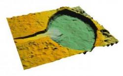
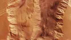
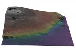
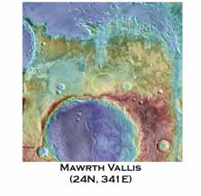
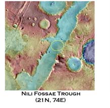
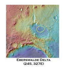
Many basin-like features observed on the Martian surface appear to have a fanned feature around possible inlets. Much like river deltas, scientists believe these Mars inlets have similar properties as their terrestrial counterparts, where the flow of water would slow into a basin reservoir, dropping suspended material and depositing it as silt, forming deltas. However, some Martian delta features have a stepped structure. This is not observed on the Earth, so how were they formed on Mars? Researchers suggest sudden flows of water may be to blame…

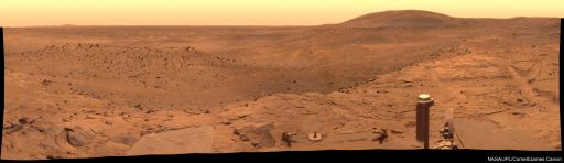
More and more evidence for ancient Mars water appears to be accumulating every day as images continue to be sent back from the numerous orbiting satellites and two rovers, Mars Explorer Rovers Opportunity and Spirit. Although recent findings suggest the water may have been poisonous to life on early Mars, reducing the likelihood of finding ancient microbial life, the nature and mechanics of water storage and release will be of tremendous value to understanding the evolution of the planets and perhaps helping future Mars colonies when tapping into a source of H2O.

Using a laboratory experiment intended for science students, researchers from Utrecht University, in the Netherlands, were able to reproduce stepped river deltas by pouring water through a flume, filled with a hollowed out sand basin. On pouring water in bursts, sand sediment was eroded from the inlet channel and deposited in the basin reservoir. As the bursty water input continued, steps in the sediment were created as the sand was deposited in layers.

The research to be published in Nature (Feb. 21, 2008), “Martian stepped-delta formation by rapid water release,” is able to draw some parallels with images being sent back from the Mars Orbiter Laser Altimeter (MOLA) on board the Mars Global Surveyor (MGS) and characterize this one source of Martian water. Based on MOLA observations of fans of 20 kilometers in basins of 100 kilometer-scale on Mars, they calculated the conditions for the creation of a stepped fan and found that by comparing with sediment transportation models, that these stepped features would only take a few tens of years to form. This is in striking contrast to other hydrologic features on Mars that take anywhere between hundreds to millions of years to form. Stepped delta features would therefore require large volumes of fast-flowing water to be created.

One possible reason for this sudden release of water could be from sub-surface pressures, as explained by Erin R. Kraal, now a geosciences research scientist at Virginia Tech, “We suggest the water was released internally, such as hydrothermal water suddenly pushed to the surface.”

Although the search for life may have taken a serious blow, future Mars settlement planners will be enthusiastic about finding sites for aquifers to sustain future human exploration of the Red Planet.

Source: Physorg.com

Valles Marineris, the Deepest Chasm in the Solar System

candorchasma.thumbnail.jpg

The photographs coming back from the Martian orbiters sure help you appreciate the very different terrain on the Red Planet. And here’s an example of one of the extreme places on Mars: the Valles Marineris the deepest, longest valley in the Solar System. The image was captured by ESA’s Mars Express spacecraft and reveals a region of the valley called Candor Chasma.

Take a look at a photograph of Mars, and it’s easy to spot Valles Marineris. It’s a 3,000 km-long (1,800 mile) gash carved in the side of the Red Planet. Planetary geologists think it formed around the same time as the nearby Tharsis Bulge – the volcanic region that houses Olympus Mons, the largest mountain in the Solar System.

It’s likely a rift valley, similar to the East African Rift Valley here on Earth. As the giant volcanoes formed, the Valles Marineris opened up as a crack in the ground. Flowing carbon dioxide could have weathered it further, eroding it and forcing the walls to cave in.

As I mentioned above, this is just a tiny portion of the whole rift. The canyon walls tower 8,500 metres (28,000 feet) above the floor below.

And if there was one place in the whole Solar System that I could travel to and see with my own eyes, it would be right here. So come on NASA, hurry up with that mission to Mars already.

Original Source: ESA News Release

Finding “Tightens the Noose on the Possibility of Life” on Mars

mro.thumbnail.jpg

So far, the Mars Exploration Rover (MER) Mission has turned up very little evidence that there is, or was, life on the Red Planet. Even more bad news is on the way from data sent back from NASA rovers Opportunity and Spirit – it would seem that the planet was “too salty” for even the toughest organisms on Earth to survive. It would appear, from new results presented at the American Association for the Advancement of Science (AAAS) in Boston, that although Mars had abundant supplies of water in the past, its oceans would have been too acidic, with poisonous concentrations of minerals. Even when conditions were best on the surface, the very toughest microbes will have found it difficult…

The NASA MER mission has been a resounding success. Both Opportunity and Sprit have operated on Mars longer than any mission scientist would have dreamed. So far, both rovers have been trundling around on the planet for nearly four years, and have carried out some exciting science, analysing the Martian regolith and rocks, observing atmospherics and geology, not forgetting the spectacular panoramic photography… but they have yet to find any compelling evidence for life. Even after the excitement of Spirits big discovery back in Decemeber, the hunt for Martian life remains inconclusive.

Now, it seems, there’s another blow for life on Mars – it’s too salty. It’s been known for a long time that Mars once had large quantities of water, giving hope that life once thrived on the planet. But these new findings suggest the water may have been too rich in minerals, making it very difficult for life (as we know it) to survive.

It was really salty – in fact, it was salty enough that only a handful of known terrestrial organisms would have a ghost of a chance of surviving there when conditions were at their best.” – Dr Andrew Knoll, a biologist at Harvard University, speaking at the AAAS meeting.

Where Opportunity is right now - in Duck Bay (credit: NASA/JPL)
This news comes from Opportunity, currently working in Duck Bay (an alcove attached to Victoria Crater, pictured left) and these new results come from rock analysis in the region. Although this may be discouraging for scientists trying to find life on Mars, this is by no means the final straw. The Phoenix Mission is currently en-route to Mars and one of its mission objectives is to carry out advanced analysis for Martian life. Phoenix lands on May 25 of this year to hunt for life in the frozen North Pole. Also, the Mars Science Laboratory (MSL) is expected for launch in 2009 and will continue the hunt for organic compounds in the Martian regolith.

Source: BBC

Mars in Thrilling 3-D!

hrsc25666.thumbnail.jpg

I know this is going to sound like an advertisement for a B-movie, but you can see Mars in 3-dimensions, thanks to a new set of data released by the European Space Agency. The images were captured by its Mars Express spacecraft using special techniques so they could later be stitched together into 3-dimensional images. Next up, Smell-O-Vision?

ESA announced the release to the Internet of their new Digital Terrain Model data set today. When you’re looking at bird’s eye images of terrain, it’s hard to get a sense of elevation, or features of the surrounding topography. These models recreate a 3-dimensional view of the terrain so that scientists can virtually “stand” on a planetary surface and look around.

The image associated with this story is of Olympus Mons, the tallest mountain in the Solar System. The different colours are associated with different elevations.

To build these kinds of images in the past, you needed a spacecraft to make multiple passes over terrain. This is just like how you can construct a 3-dimensional model in your brain. Because you use two eyes, the multiple images can be stitched together to give a stereo view.

But Mars Express is different. Its High Resolution Stereo Camera can build up 3-D images in just a single pass. It has 9 individual scan lines that point ahead, behind, and straight down. It can then gather everything it needs by passing over terrain. Scientists back on Earth can stitch the images together on computer to create the 3-dimensional view.

It’s also equipped with a laser altimeter instrument that allows it to measure the height to every point it sees. This helps build up a topographical map of the terrain.

One of the best ways to look at the images coming back from Mars is with the HRSC Image viewing tool. Check it out.

Original Source: ESA News Release

Are the Martian Winds Still Resurfacing the Planet?

marsdustdevils.thumbnail.jpg

The Martian atmosphere is tenuously thin; just 1% as thick as the Earth’s. And yet, it boasts a surprising array of weather systems, including clouds and global dust storms. The winds push dunes across the Martian surface and towering dust devils carve crisscrossed trails across the desolate landscape.

Here on Earth, wind, water and the slow movement of tectonic plates reshape the surface of our planet. On Mars, though, there’s not a drop of liquid water to be seen, and the planet’s plates seized up eons ago.

Only wind remains to rework the surface of the planet. But scientists wonder if the features we see on Mars today were formed recently by the blowing winds, or were created eons ago, when the winds and air pressure were much stronger.

Recent images from NASA’s Mars Reconnaissance Orbiter show various regions of Mars pushed around by winds.

“We’re seeing what look like smaller sand bedforms on the tops of larger dunes, and, when we zoom in more, a third set of bedforms topping those,” said HiRISE co-investigator Nathan Bridges of NASA’s Jet Propulsion Laboratory in Pasadena, Calif. “On Earth, small bedforms can form and change on time scales as short as a day.”

With the high-resolution HiRISE camera on MRO, scientists are able to see details for the first time. The images show sediments deposited on the downwind side of rocks. These windtails show where the most current winds have blown. When the winds change directions, the old windtails are obscured, and new ones are formed behind the rocks. This technique allows researchers to map wind directions across the entire planet.

Scientists have also discovered wind-scoured ridges called “yardangs”. The HiRISE images show their surface texture and fine-scale features to help explain how they form.

“HiRISE is showing us just how interesting layers in yardangs are,” Bridges said. “For example, we see one layer that appears to have rocks in it. You can actually see rocks in the layer, and if you look downslope, you can see rocks that we think have eroded out from that rocky layer above.”

And in the image attached with this story, you can see the paths taken by dust devils as they pass across the surface of Mars.

Original Source: NASA/HiRISE News Release

Amazing Panorama of Mars’ Victoria Crater from Opportunity

The images coming from Mars seem to get better and better. Mars rover Opportunity is currently sitting in an alcove of Victoria Crater (called Duck Bay), in the Meridiani Planum region, carrying out rock sample analysis. The soon-to-be four year old robotic wheeled explorer has taken it’s fair share of pictures of the Martian landscape, but this most recent panoramic effort oozes with detail and color (and without a Red Planet Yeti in sight)…

The Mars Expedition Rovers (MER), Opportunity and Spirit have been trundling around on the Mars surface for nearly four years (can you believe it?), carrying out experiments on the Mars rock and regolith. These tests are be essential for future missions to the Red Planet. But, by far the most striking results come from the high definition, ground level images they transmit to Earth, to our computers and TV screens. And this panorama looking over the famous Victoria Crater is up there with the best pictures ever to be captured by the Mars rover missions.

This panorama comes from Opportunity‘s Pancam (panoramic camera) instrument taken over the course of 47 sols (or Martian days) from the 1,332nd to the 1,379th sol of the MER mission (from October 23 to December 11, 2007). Pancam applies three different filters (at 753, 535 and 432 nanometers – optical wavelengths, from red to blue) and mixes the three images to form this view. The color combination method helps the viewer to pick out features in the landscape and amplifies subtle color differences in the scene.
Looking over Duck Bay and the current position of Opportunity - MRO image (credit: NASA/JPL)
Probably the most startling features in the panorama are the rocky outcrops leading to the basin of the Victoria Crater toward the upper right of the image. On studying the scene, you can see tracks in the regolith formed by Opportunity‘s wheels leading up the slope in Duck Bay. The fine detail also reveals the cracked structure of the parched land stretch into the distance. The rover’s solar panels also display a feast of color, brightening up the red of the landscape.

See Duck Bay and the entrance to Victoria Crater in all its glory as a high-resolution image (very big file: 24MB, so be sure to have a fast connection, or a free morning – the wait will be worth it!). However, don’t expect to see anything of the much hyped Mars “Big Foot”, there ain’t no humanoids there

Source: Physorg.com

No Humanoid on Mars, Just Rocks

Okay, once and for all, let’s make this clear. In the words of our esteemed Bad Astronomer, Phil Plait, “repeat after me:” A humanoid was not photographed on the surface of Mars. And NASA is not covering up this photo in the name of national security. Furthermore, human missions to Mars have not been cancelled because of this photo. These outrageous notions keep popping up in the media. The photograph, which was taken by Spirit, one of the Mars Exploration Rovers, is just another example of pareidolia, our ability to see patterns in random shapes.

As happens frequently, people tend to see faces or human forms in things like clouds, wood grain, and pancakes. This is only an optical illusion. If you need proof of this, for those of you in the US, look at one of the state-themed quarters from New Hampshire. There you can see the Man in the Mountain, a case of pareidolia that became an historic site (which has since crumbled.)

The photo shown here is the very large panoramic image from which a teeny, tiny rock formation was found that looks kind of human-like. Someone had to be looking really close to see it, as the rock formation is only about 6 centimeters high, and in the image you can also see a hill that’s over 8 kilometers (5 miles) away.

If you have any doubts in your mind that this is nothing more than just a very small, unusual rock formation, please, please, please see Emily Lakdawalla’s thorough explanation of the image at the Planetary Society’s website, which includes 3-D pictures that really make it clear this is not a humanoid. It’s a rock with a funny shape. And Phil the Bad Astronomer has more info on it as well here and here.

And, okay, here’s the really zoomed in image crop that has caused such a hubbub. Just remember how small this rock really is.
tiny detail from a panorama taken by the Mars Exploration Rover Spirit on sol 1,366-1,369 (November 6-9, 2007) of its position on the eastern edge of Home Plate. Credit: NASA / JPL / Cornell

Ice Clouds on Mars Create Shade

shadowcloud1_l.thumbnail.jpg

Until now, Mars has generally been regarded as a desert world, where a visiting astronaut would be surprised to see clouds drifting across the orange sky. But new data and images show that Mars does indeed have clouds, and some are actually thick enough to cast a shadow on the planet’s surface. These are clouds of dry ice, or carbon dioxide (CO2), and sometimes they are so large and so dense that they throw quite dark shadows on the dusty surface. This, in turn, can affect the weather patterns on Mars. Researchers also say this discovery could help to understand Mars’ climate history.

Data obtained from ESA’s Mars Express OMEGA Visible and Infrared Mineralogical Mapping Spectrometer instrument has been analyzed by a group of French scientists.

“This is the first time that carbon dioxide ice clouds on Mars have been imaged and identified from above,” said Franck Montmessin of the Service da Aeronomie, University of Versailles. “This is important because the images tell us not only about their shape, but also their size and density.”

Clouds of water ice particles have previously been seen, for example on the sides of the giant Martian volcanoes. There have also been hints of much higher, wispy clouds made up of carbon dioxide (CO2) ice crystals. This is not too surprising, since the thin Martian atmosphere is mostly made of carbon dioxide, and temperatures on the fourth planet from the Sun often plunge well below the ‘freezing point’ of carbon dioxide. But these clouds are not very thick.

But the CO2 clouds detected by OMEGA are very different. Not only are they surprisingly high — more than 80 km above the surface — but they can be several hundred kilometers across. They are also much thicker than expected. Instead of looking like the wispy ice clouds seen on Earth, they resemble tall convectional clouds that grow as the result of rising columns of warm air.

Even more surprising is the fact that the CO2 ice clouds are made of quite large particles – more than a micron (one thousandth of a millimeter) across — and they are sufficiently dense to noticeably dim the Sun. Normally, particles of this size would not be expected to form in the upper atmosphere or to stay aloft for very long before falling back towards the surface.

“The clouds imaged by OMEGA can reduce the Sun’s apparent brightness by up to 40 per cent,” said Montmessin. “This means that they cast quite a dense shadow and this has a noticeable effect on the local ground temperature. Temperatures in the shadow can be up to 10 degrees C cooler than their surroundings, and this in turn modifies the local weather, particularly the winds.”

Since the CO2 clouds are mostly seen in equatorial regions, the OMEGA team believes that the unexpected shape of the clouds and large size of their ice crystals can be explained by the extreme variations in daily temperature that occur near the equator.

“The cold temperatures at night and relatively high day-time temperatures cause large diurnal waves in the atmosphere,” explained Montmessin. “This means there is a potential for large-scale convection, particularly as the morning Sun warms the ground.”

“This discovery is important when we come to consider the past climate of Mars,” Montmessin continued. “The planet seems to have been much warmer billions of years ago, and one theory suggests that Mars was then blanketed with CO2 clouds. We can use our studies of present-day conditions to understand the role that such high level clouds could have played in the global warming of Mars.”

Original News Source: ESA Press Release

Landing Sites for Mars Science Lab Narrowed to Six

msl.thumbnail.jpg

Where should the next spacecraft land on Mars? The Mars Science Laboratory (MSL) rover is scheduled to launch in the fall of 2009. MSL is a long-range rover that will explore a region on Mars with the goal of determining if Mars has or ever had conditions capable of supporting microbial life. Over fifty landing sites have been proposed by various planetary scientists, and recently, the selection committee narrowed the field down to six possible sites. The final site and a backup will be selected in September of 2008. Here’s a look at the six final candidates:

Mawrth Vallis: Location:Northern Plains, east of Pathfinder rover site (24.65°N, 340.10°E)
Mars Global Surveyor MOLA Instrument
This is an ancient channel carved by catastrophic floods. Spectrometers on the Mars Reconnaissance Orbiter (MRO) have detected clay minerals which contain water, and may also preserve organic materials, so there is great interest in studying these deposits to understand past environments that could have supported life. Images from the MRO HiRise camera show hills with several layers and intriguing boulders.

Nili Fossae Trough: Location: Near Isidis Planitia, and near the Beagle 2 intended landing site. (21°N, 74.2°E)
Nilli Fossae Trough.  Image Credit:  Mars Global Surveyor MOLA Instrument
This region has one of the largest and most diverse exposures of clays minerals that have been detected from orbit. Again, clay minerals contain water, and possibly organic materials. The area is a linear depression about 25 km wide that was created from tectonic activity.

Holden Crater: Location: South of Vallis Marineris (26.4°S, 325.3°E)
Holden Crater.  Image Credit:  Mars Global Surveyor MOLA Instrument
This crater contains deep gullies carved by running water as well as examples of what are assumed to be lake beds and sediments deposited by streams. These deposits are more than three billion years old, which dates back to a wetter period on Mars. Scientists believe Holden Crater once was a lake, and when the water disappeared, wind eroded the surface and formed the ripples and dunes that have been imaged by the HiRise instrument.

Eberswalde Crater: Location: South of Vallis Marineris (23.20°S, 326.75°E)
Eberswalde Delta.  Image Credit:  Mars Global Surveyor MOLA Instrument
The Eberswalde delta is the most convincing evidence on Mars for the persistent flow of a river into a standing body of water. HiRise images show many channels within the delta that have become inverted, which occurs as sediments deposited by flowing water solidify over time and become resistant to erosion. High resolution HiRise images show individual boulders breaking off from the channel deposits.

Miyamoto Crater: Location: Merdiani Planum, near Opportunity Rover site. (1.7°S, 352.4°E)
Miyamato Crater.  Image Credit:  Mars Global Surveyor MOLA Instrument
Located along the western boundary of Meridiani Planum, this 150-km crater has hematite and sulfate-bearing minerals, possibly created from lakes or groundwater. The southwestern part of the crater floor has been stripped by erosion, revealing clay minerals.

Northern Meridiani: Location: Meridiani Planum,2.34°N, 6.69°E
Meridiani.  Image Credit:  Mars Global Surveyor MOLA Instrument
This is the same area that the Opportunity rover has studied. By landing here, the MSL rover could increase our knowledge of the Meridiani region, which Opportunity has revealed to have a complex geologic history that involves flowing water, groundwater, lakes and wind. If chosen as a landing site, the MSL rover would study the smooth plains before driving to the ridged plains to the north.

MSL will arrive on Mars in 2010. Once on the surface, the rover will be able to roll over obstacles up to 75 centimeters (29 inches) high and travel up to 90 meters (295 feet) per hour. On average, the rover is expected to travel about 30 meters (98 feet) per hour, based on power levels, slippage, steepness of the terrain, visibility, and other variables. The science instruments on board include cameras, spectrometers, radiation detectors and environmental sensors.

Original News Source: HiRise Blog

1-in-75 Chance Of Tunguska-Size Impact On Mars

mars_asteroid.thumbnail.jpg

A 164-foot (50 meter) wide asteroid will be crossing the orbit of Mars at the end of January 2008. Currently, there is a 1-in-75 chance of the “Mars Crosser” hitting the Red Planet, and if it does, the 30,000 mile per hour speeding mass would generate a three megaton explosion (approximately the size of the terrestrial Tunguska impact over Siberia in 1908) and create a crater half-a-mile wide somewhere north of Meridiani Planum. So, the Mars Rover Opportunity will get a ringside seat should this once-in-a-thousand-year event occur…

NASA’s Near-Earth Object Office at the Jet Propulsion Laboratory (JPL) in Pasadena, California reported this month that a known Near Earth Asteroid (NEO) will be crossing the path of Mars on January 30, 2008. This puts asteroid “2007 WD5” in a special group of asteroids: “Mars Crossers“. NASA’s Near Earth Object Observation Program (or “Spaceguard” program) is intended to track asteroids that come close to the orbit of Earth, but also provides data for any asteroids tracked near our planetary neighbors.

Scientists are both excited and concerned by the possibility of an impact on Mars. Whilst this is a once in a lifetime opportunity to observe an impact of this size on Mars (remember the excitement at Shoemaker-Levy hitting Jupiter in 1994?), this event would eject millions of tons of dust into the Mars atmosphere, interfering with the Mars Expedition Rovers, and hindering orbital imaging of the planet. The Phoenix mission (currently en-route) will undoubtedly be affected. Looking far into the future, this event could have serious consequences for manned exploration.

“Right now asteroid 2007 WD5 is about half-way between the Earth and Mars and closing the distance at a speed of about 27,900 miles per hour […] Over the next five weeks, we hope to gather more information from observatories so we can further refine the asteroid’s trajectory,” – Don Yeomans, manager of the NEO Office at JPL.

Although the odds are low, and the asteroid is expected to miss Mars by 30,000 km, asteroid hunters will be keeping a close eye on the progress of 2007 WD5 as it barrels closer and closer to the Red Planet and our robotic explorers.

Source: Near Earth Object Program