Phoenix in the Land of Mars’ Midnight Sun

Mars' Midnight Sun. Credit: NASA/JPL-Caltech/U of Arizona/Texas A&M University

[/caption]
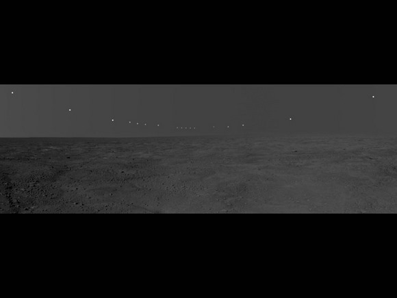
This panorama mosaic of images was taken by the Surface Stereo Imager on board NASA’s Phoenix Mars Lander. This mosaic documents the midnight sun during several days of the mission, from Sol 46, or the 46th day of the mission to Sol 56 (that would be to July 12 – 22, 2008 here on Earth.) The foreground and sky images were taken on Sol 54, when the lander pulled an all-nighter to coordinate work with the Mars Reconnaissance Orbiter. The solar images were taken between 10 p.m. and 2 a.m., local solar time, on the different nights of the 11 sol period. During this period, the sun’s path got slightly lower over the northern horizon, causing the lack of smoothness to the curve. This pan captures the polar nature of the Phoenix mission in its similarity to time lapse pictures taken above the Arctic Circle on Earth.

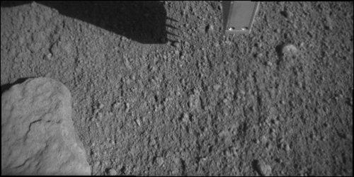
The latest activities of the lander has brought it closer to analyzing a sample of icy soil in the TEGA oven.

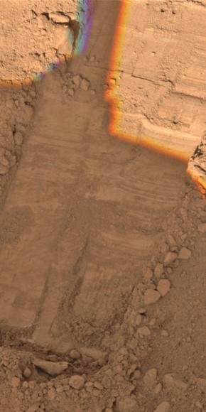
On Tuesday and Wednesday, Phoenix used its robotic arm to scrape the top of the hard layer in the trench called “Snow White.”

“We are monitoring changes between the scrapes,” said Doug Ming of NASA Johnson Space Center. “It appears that there is fairly rapid sublimation of some of the ice after scraping exposes fresh material, leaving a thin layer of soil particles that had been mixed with the ice. There’s a color change from darker to bluer to redder. We want to characterize that on Sol 58 to know what to expect when we scrape just before collecting the next sample.”

The science team is preparing to quickly collect a sample from the hard layer of Snow White and deliver it to one of the eight ovens of Phoenix’s Thermal and Evolved-Gas Analyzer (TEGA). Doors to the oven have been opened to receive the sample. TEGA will “bake and sniff” the samples to analyze the composition of the soil and ice.

On Wednesday the team also checked out the heater on TEGA is working properly, to verify that pressure sensors can be warmed enough to operate properly early in the Mars morning.

“For the next sample, we will be operating the instrument earlier in the morning than we have before,” said William Boynton of the University of Arizona, lead scientist for TEGA. “It will be almost the coldest part of the day, because we want to collect the sample cold and deliver it cold.”

On the day when Phoenix will deliver the next sample to TEGA, the team plans to have lander activities begin about three hours earlier than the usual start time of about 9 a.m. local solar time.

On Thursday, one set of imaging commands will check a northwestern portion of the horizon repeatedly during early afternoon to see whether any dust devils can be seen. This will be the first systematic check by Phoenix for dust devils. The Mars Rover Spirit was able to image sequences of dust devils in its location, south of Mars’ equator.

Original News Source: Phoenix News

Phoenix Lander Couldn’t Sleep At All Last Night

TEGA oven doors wide open. Credit: NASA/JPL-Caltech/University of Arizona/Texas A&M University

[/caption]
For the first time, the Phoenix lander stayed up all night. But there was no partying for the little lander, just hard work. Phoenix coordinated its schedule to work together with the Mars Reconnaissance Orbiter to make joint observations to study Mars’ atmosphere. More on that in a minute, but the other big news from the Phoenix lander is that the doors to the Thermal and Evolved Gas Analyzer (TEGA) oven successfully opened, and the device is now ready to accept a sample of icy soil. If you remember, way back in the beginning of the mission, on about Sol 8, the first time the science team relayed orders for the spring-loaded oven doors to open, the doors only opened partially and the team had to vibrate the oven to get the soil inside. But this time, the 10 cm (4 inch) doors stands wide open, and today Phoenix will perfect its techniques to quickly get the icy soil sample inside the oven before the ice sublimates.

Now, about those atmospheric observations: Phoenix used its weather station, stereo camera and conductivity probe to monitor changes in the lower atmosphere and ground surface at the same time MRO studied the atmosphere and ground from above. The orbiter flew repeatedly over Phoenix’s location last evening, so it was good timing for a coordinated effort.

“We are looking for patterns of movement and phase change,” said Michael Hecht, lead scientist for Phoenix’s Microscopy, Electrochemistry and Conductivity Analyzer, which includes the lander’s fork-like thermal and conductivity probe. “The probe is working great. We see some changes in soil electrical properties, which may be related to water, but we’re still chewing on the data.”

The probe was inserted into the soil Sunday for more than 24 hours of measurements coordinated with the atmosphere observations. One goal is to watch for time-of-day changes such as whether some water alters from ice phase to vapor phase and enters the atmosphere from the soil.

The Phoenix team’s plans also include commanding the lander to conduct additional testing of the techniques for collecting a sample of icy soil. When the team is confident about the collecting method, it plans to use Phoenix’s robotic arm to deliver an icy sample to an oven of TEGA.

The team wants to make sure their techniques will quickly bring the soil into the oven, as it’s possible the oven will only work for one more test. The vibrating done to get the soil into the oven for the previous test caused a short circuit that may happen again the next time the oven is activated. The short could be fatal to the oven, but of course, we’re all still holding out hope for a better case scenario.

Original News Source: Phoenix News site

Mars Arctic in 3D from Phoenix

OK, everyone: get out your funky 3-D glasses for a whole new look at Mars! We’ve seen the smooth plains of Meridiani from Opportunity in 3-D; we’ve gazed upon the rocky terrain of Gusev Crater from Spirit in more than two dimensions. But now it’s time to feast your eyes on Mars’ arctic tundra as its never been seen before: in super frozen 3-D from the Phoenix lander! The image above shows a color, stereoscopic 3D view of the Martian surface near the lander, and is one of Phoenix’s workplaces called “Wonderland.” But wait! There’s more…..


This 3-D view is from an image acquired by Phoenix’s Surface Stereo Imager on Sol 33, the 33rd Martian day of the mission (June 28, 2008). Phoenix’s solar panel is seen in the bottom right corner of the image.


Here’s a close up view of where all the action has been taking place recently: the trench called “Snow White.” The hole to the left of the trench, seen in the upper left of the image, is informally called “Burned Alive. This image was taken on Sol 22, but recently, Phoenix has scooped and rasped the area in an effort to get “shaved ice” samples.

Here’s a great touchy-feely 3-D image (don’t you just want to reach out and touch that rock?) The largest rock seen in this image is called “Midgard.” The edge of Phoenix’s deck is seen in the bottom right corner of the image.

There’s lots more 3-D loveliness at the Phoenix Image Gallery. Have fun!

How Future Missions Could Detect Organisms Inside Rocks on Mars

Jarosite in New Zealand. Credit: Michelle Kotler

[/caption][/caption]
For a geologist, looking inside a rock is essential to help determine the makeup and history of the rock sample. That’s why geologists have rock hammers, and also why the Mars Exploration Rovers, Spirit and Opportunity, have their Rock Abrasion Tool. For future missions to Mars, or even for a sample return mission, one of the main goals will be to look for signs of life, past or present, that might be hiding inside the rocks. Scientists are working on a new, simple technique for detecting biological and pre-biotic molecules that become trapped inside the minerals in rocks.

This new technique utilizes a laser-based optical and chemical imager or LOCI. A single laser shot vaporizes a small portion of the surface into individual ions. These pass through a mass spectrometer, which can identify each ion by how much mass and charge it has. The great thing about this technique is that the sample requires no preparation: just shoot and detect.

Previous techniques for required that the minerals be dissolved in a solution or mixed in with some other medium, which dilutes the sample and runs the risk of introducing contamination.

Jill Scott of Idaho National Laboratory with the laser-based optical and chemical imager (LOCI). Credit: Idaho National Lab
Jill Scott of Idaho National Laboratory with the laser-based optical and chemical imager (LOCI).  Credit: Idaho National Lab
This procedure was tested on Earth using samples of the mineral jarosite. Jarosite is a yellowish-brown sulfate mineral containing iron, potassium and hydroxide. It is found in places around the world such as southern California beaches and volcanic fields in New Zealand. It forms only in the presence of highly acidic water.

In 2004, jarosite was discovered on Mars by the rover Opportunity. Scientists immediately recognized the find as clear evidence for past water on the red planet.

But there is something else about jarosite that makes it interesting. On Earth, for jarosite to form, oxidation of the rock must occur – usually the rock is pyrite (ferrous sulfide). And on Earth, the oxidation reaction is usually performed by certain “rock-eating” microorganisms.

Scientists say the rate of the jarosite formation would be extremely slow without microbes, as well as without the presence of water.

Whether jarosite can form without the assistance of these microbes is very difficult to say, since every corner of Earth is occupied by little bugs of some sort or another.

And yet, there remains the tantalizing possibility that jarosite on Mars exists because of some little, rock-eating microbes. If so, remnants of these organisms may be locked in the mineral. And there’s only one way to find out: look inside Mars rocks.

Right now, this method couldn’t be used on the next bigger Mars rover, the Mars Science Laboratory, which will hopefully launch in 2009. The LOCI instrument is just too big and too complex to use remotely, said David Beaty, chief scientist of the Mars Exploration Directorate at the Jet Propulsion Laboratory.

But it could be used on a sample return mission. But hopefully, scientists will be able to develop a smaller, simpler version to be used on future missions to look for signs of life in rocks on Mars.

Original News Source: Astrobiology Magazine

The Mysterious Mars Mounds

The mystery mounds on Mars. Credit: HiRISE/NASA

[/caption]

The High Resolution Imaging Science Experiment (HiRISE) continues to churn up stunning images as NASA’s Mars Reconnaissance Orbiter passes over the Martian surface. However, today’s example probably creates more questions than answers. Close to the Mars equator, south of Elysium Planitia, exists a crater and inside are some strange mounds that have so far eluded formal explanation. There are a few possibilities how these mounds may have formed and there may also be some examples on Earth too…

These features resemble mesas being stripped by Martian winds, or a build-up of sand/sediment dropped after a sand storm. Actually, these “mystery” features are not formed by sand and may not have been carved out by the wind. This image was commissioned by the HiRISE team to investigate a previous Mars Orbital Camera (MOC, on the Mars Global Surveyor) image of the region showed an ancient filled-in crater with some strange undulations in the bottom. Using the full 25 cm/pixel resolving power of HiRISE, these features can be seen in great detail.

NASA/JPL/University of Arizona
The full HiRISE image of the region. Credit: NASA/JPL/University of Arizona

The largest mounds appear to be around 200 meters wide and vary in shape. Between the mounds appear to be wind-blown sand features, but scientists cannot explain the formation of the mounds at present. Attention is being paid to the rough surface texture of the mounds which suggests they may be outcrops of tough bedrock where loose sand or sedimentary rock has been eroded away, leaving the mounds behind. But how did this erosion occur and why is the bedrock so hardy?

The mounds could be ancient lava flows, fluvial sediment (indicating a plentiful supply of water in the past) or impact ejecta (i.e. hot material kicked into the old crater after another impact). Any one of these factors may have produced these hardened features. The strange thing is that there is a huge plain of these mounds, they aren’t isolated features. To be able to determine the origin of these mounds, further analysis needs to be carried out. The Compact Reconnaissance Imaging Spectrometer for Mars (CRISM) on board the Mars Reconnaissance Orbiter will now be used to derive the mineral content of the region so a better understanding can be attained. But until then, these mounds will remain a true Martian mystery…

Source: HiRISE

Geologists Predicted Mars Avalanche

A Mars Avalanche, taken by NASAs HiRISE instrument on the Mars Reconnaisance Orbiter (Credit: NASA/HiRISE)

Remember the amazing images of an avalanche on Mars back in March of this year from the HiRISE camera on the Mars Reconnaissance Orbiter? If not for two geologists studying landforms in Alaska, MRO scientists might not have been on the lookout for such an event, or may not have known what they were seeing. A serendipitous week-long trip to Alaska by Craig Kochel and Jeffrey Trop, geology professors at Bucknell University, helped them predict one of the most important, and breathtaking planetary observations ever made. Witnessing an avalanche, or landslide in action on Mars has helped us realize the Red Planet is still a dynamic, ever-changing planet.

The two geologists were in Alaska for an eight day trip in July 2006, studying geological features and the processes that create them. In preparing for the trip, they looked at photographs of the area they would be hiking through and noticed several features in the photographs that looked familiar. Kochel thought they reminded him of images he’d seen when working on the Viking missions to Mars in the 1970s. In both the photographs and while they were hiking they saw triangle-shaped landforms called “fans” that especially looked like features on Mars. But, at first they didn’t know what they were.

During their short time in Alaska they saw over 200 snow, ice and/or rock avalanches. They realized these events were creating the fan-like features in Alaska, and determined similar avalanches on Mars were creating those same features. Additionally, they believed avalanches could still occur on Mars due to changes in temperatures from sunlight hitting a cliff wall.

At a presentation at the Lunar and Planetary science conference, Kochel and Trop shared their findings and explained that with a bit of luck and good timing, it would be possible to snap photographs of Martian avalanches.

Amazingly, soon afterwards the orbiter sent back images of an ice flow avalanche in action on Mars. Pieces of ice, dust and possibly rocks crashed down from high, steep areas, sending clouds of fine material billowing upwards. The cloud itself was about 180 meters across. The exact cause of the avalanche isn’t known with certainty, but it could be because the sun warmed layers of ice. This was the first time an avalanche had been observed on another world, and was the perfect confirmation of Kochel and Trop’s ideas.

Studies like this show that although Earth and Mars are very different places, in many ways they can be astoundingly similar.

Here are more images of the Mars Avalanche.

Original News Source: Astrobiology Magazine

Olympus Mons: The Largest Volcano in the Solar System

Olympus Mons from Orbit
Olympus Mons from orbit. Credit: NASA

The largest volcano in the Solar System and the largest mountain in the Solar System are one in the same: Olympus Mons on Mars.

Olympus Mons is a shield volcano that towers to an amazing 26 km. That makes it 3 times the height of Mt. Everest. Unlike Everest, Olympus Mons has a very gentle slope. It is up to 550 km at its base. The edge of the volcano’s base is marked by a basal cliff that is 6 km high in some places, but has been eradicated by the overflow of lava in the Martian past.

Olympus Mons is the result of many thousands of basaltic lava flows. The extraordinary size of the volcano has been attributed to the lack of tectonic plate movement on the planet. The lack of movement allows the Martian crust to remain fixed in place over a magma hotspot allowing repeated, large lava flows. Many of these flows have levees along their edges. The cooler, outer margins of the flow solidify, forming the levees and leaving a central trough of molten, flowing lava. In images of the volcano you can see partially collapsed lava tubes seen as chains of pit craters. Broad lava fans formed by lava emerging from intact, subsurface tubes are easily visible as well. Some areas along the volcano’s base show lava flows spilling out into the surrounding plains, forming broad aprons, which are burying the basal escarpment. Crater counts taken by the high resolution images returned by the Mars Express spacecraft in 2004 seem to show that flows on the northwestern flank range in age from 2 million years old to 115 million years old. Since these flows are geologically young, it may indicate that the volcano is still active.

The Olympus Mons caldera complex is made up of at least six overlapping calderas and segments of caldera. Each caldera formed when the roof collapsed following depletion and retreat of the subsurface magma chamber, so each caldera represents a separate eruption. A ‘lake of lava’ seems to have formed the the largest and oldest caldera segment. Using geometric relationships based on caldera dimensions, scientists estimate that the magma chamber associated with this caldera lies about 32 km below the floor of the caldera. Crater size/frequency distributions indicate the calderas range in age from 350 million years ago to about 150 million years ago and may have all formed within 100 million years of each other.

As the largest volcano in the Solar System, Olympus Mons has been extensively studied. Those studies have been helped by the closeness of Mars. Those studies will continue into the future as will the exploration of the entire planet.

We’ve had many stories about Olympus Mons on Universe Today. Here’s an article about landslides on the side of Olympus Mons, and anther about how Olympus Mons might have been active recently.

Here’s a website all about Olympus Mons, and more information from Exploring Mars.

We have recorded a whole series of podcasts about the Solar System at Astronomy Cast. Check them out here.

References:
NASA StarChild
NASA: Olympus Mons from Orbit

Phoenix’s Rasp Works to Create Ice Shavings

The Phoenix Mars Lander successfully used a rasp on the end of its robotic arm to drill into the frozen soil on Mar’s arctic tundra. This effort loosened the icy material, which was then scraped up and collected in the lander’s scoop. Images and data sent from Phoenix early today indicated the shaved material in the scoop had changed slightly over time during the hours after it was collected, which is a sign that the material includes water ice. Water ice sublimates, or evaporates on Mars surface because of the low surface pressure on the Red Planet. It can exist just under the surface, however, protected by the soil.

The motorized rasp — located on the back of the lander’s robotic arm scoop — made two distinct holes in a trench informally named “Snow White.” The material loosened by the rasp was collected in the scoop and documented by the Robotic Arm Camera. The activity was a test of the rasping method of gathering an icy sample, in preparation for using that method in coming days to collect a sample for analysis in an oven of Phoenix’s Thermal and Evolved-Gas Analyzer (TEGA).

“This was a trial that went really well,” said Richard Morris, a Phoenix science team member from NASA’s Johnson Space Center, Houston. “While the putative ice sublimed out of the shavings over several hours, this shows us there will be a good chance ice will remain in a sample for delivery” to Phoenix’s laboratory ovens.

The motorized rasp bit extends from the back of the scoop on the end of Phoenix’s 2.35-meter-long (7.7-foot-long) robotic arm. The tool works just a rasp for woodworking, which coarsely files or shaves material.

‘While Phoenix was in development, we added the rasp to the robotic arm design specifically to grind into very hard surface ice,’ said Barry Goldstein, Phoenix project manager at NASA’s Jet Propulsion Laboratory, Pasadena, Calif. ‘This is the exactly the situation we find we are facing on Mars, so we believe we have the right tool for the job. Honeybee Robotics in New York City did a heroic job of designing and delivering the rasp on a very short schedule.'”

The past few days, Phoenix used its robotic arm to clear the top layer of dirt from a trench it dug called Snow White. On Tuesday, Phoenix used the rasp to dig into two spots at the bottom of the trench.

Mission scientists have been working on techniques to quickly obtain the sample and then deliver it to the TEGA before too much ice has sublimated away. The TEGA test will “bake” the soil, releaseing gases present to help sciencists learn more about the ice’s composition.

Today, (Wednesday) Phoenix will be commanded to continue scraping and enlarging the “Snow White” trench and to conduct another series of rasp tests. The lander’s cameras will again be used to monitor the sample in the scoop after its collection.

Original News Source: Phoenix Press Release

New Evidence for a Wetter, Warmer Ancient Mars

A 3-D image of a trough in the Nili Fossae region of Mars shows phyllosilcates (in magenta and blue hues) on slopes of mesas and canyon walls, showing water played a role in Mars’ past.

For all the Mars romanticists out there, we (yes, that means me, too) hope and maybe even dream that Mars once harbored water. And not just a little spurt of groundwater every once in awhile; we want the water to have been there in abundance and for enough time to make an impact on the planet and its environment. Now, proof of copious amounts of water in Mars’ past may have been found. Two new papers based on data from the Mars Reconnaissance Orbiter (MRO) found that vast regions of the ancient southern highlands of Mars hosted a water-rich environment, and that water played a sizable role in changing the minerals of a variety of terrains in the Noachian period – about 4.6 billion to 3.8 billion years ago.

John Mustard, a professor of planetary geology at Brown University and deputy principal investigator for the Compact Reconnaissance Imaging Spectrometer for Mars (CRISM) on MRO investigated the pervasive presence of phyllosilicates, clay-like minerals that preserve a record of water’s interaction with rocks.

Specifically, Mustard and his team from 13 other institutions focused on phyllosilicate deposits in areas like craters, valleys and dunes all over the planet. Among the highlights, he detected the clay-like minerals in fans and deltas within three regions, most notably the Jezero crater. That discovery marks the first time hydrated silicates have been found in sediments “clearly lain by water,” Mustard said.

The team also found phyllosilicate deposits in thousands of places in and around craters, including the pointed peaks located at the center of some of the depressions. This suggests that water was present 4-5 kilometers below the ancient Martian surface, the team wrote, due to the generally accepted principle that crater-causing collisions excavate underground minerals that are then exposed on the crater peaks.

“Water must have been creating minerals at depth to get the signatures we see,” Mustard said.

The clay minerals were formed at low temperatures (100-200°C) – an important clue to understanding the Red Planet’s potential for habitability during the Noachian period.

“What does this mean for habitability? It’s very strong,” Mustard said. “It wasn’t this hot, boiling cauldron. It was a benign, water-rich environment for a long period of time.”

In another paper, graduate student Bethany Ehlmann and colleagues from Brown and other institutions analyzed sediment deposits in two exquisitely preserved deltas in the Jezero crater, which held an ancient lake slightly larger than Lake Tahoe. The deltas suggest a flow from rivers carrying the clay-like minerals from an approximate 15,000-square kilometer watershed during the Noachian period.
Ehlmann said scientists cannot determine whether the river flow was sporadic or sustained, but they do know it was intense and involved a lot of water.

The deltas appear to be excellent candidates for finding stored organic matter, Ehlmann said, because the clays brought in from the watershed and deposited in the lake would have trapped any organisms, leaving in essence a cemetery of microbes.

“If any microorganisms existed on ancient Mars, the watershed would have been a great place to live,” Ehlmann said. “So not only was water active in this region to weather the rocks, but there was enough of it to run through the beds, transport the clays and run into the lake and form the delta,” she said.

Original News Source: Brown University Press Release

Phoenix Lander Tries Out Soil Probe and Atomic Microscope

It’s not that the Phoenix lander’s mission to Mars is over – not by a longshot. But Phoenix did stick a fork in it. The “fork” is a four-pronged thermal and electrical conductivity probe that Phoenix poked into the Martian soil for the first time. The probe tool can help the science team assess how easily heat and electricity move through the soil from one spike to another. These measurements can provide information about frozen or unfrozen water in the soil. The probe is mounted on the “knuckle” of Phoenix’s Robotic Arm. The probe has already been used for assessing water vapor in the atmosphere when it is held above the ground.

The image above is a series of six images, taken on July 8, 2008, during the Phoenix mission’s 43rd Martian day, or sol, since landing. The insertion visible from the shadows cast on the ground on that sol was a validation test of the procedure. The spikes on the probe are about 1.5 centimeters or half an inch long.

Phoenix also tried out another instrument: atomic force microscope. This Swiss-made microscope builds an image of the surface of a particle by sensing it with a sharp tip at the end of a spring, all micro- fabricated from a sliver of silicon. The sensor rides up and down following the contour of the surface, providing information about the target’s shape.

“The same day we first touched a target with the thermal and electrical conductivity probe, we first touched another target with a needle about threeorders of magnitude smaller — one of the tips of our atomic force microscope,”said Michael Hecht of NASA’s Jet Propulsion Laboratory, Pasadena, Calif., lead
scientist for the suite of instruments on Phoenix that includes both the conductivity probe and the microscopy station.

The atomic force microscope can provide details of soil-particle shapes as small as about 100 nanometers, less than one-hundredth the width of a human hair. This is about 20 times smaller than what can be resolved with Phoenix’s opticalmicroscope, which has provided much higher-magnification imaging than anythingseen on Mars previously.

The team for the robotic arm is still working out the best way to get samples of ice from the trench dug earlier called “Snow White,” and be able to transfer the samples quickly into the Thermal and Evolved-Gas Analyzer (TEGA) which heats samples and identifies vapors from them.

Scientists have yet to release any information about the second test from the Wet Chemistry Lab. They are still analyzing the results.

Original News Source: NASA’s Phoenix site