Analogue astronauts have tested a ground-penetrating radar named ScanMars at a Mar-like area in Oman. Image: OEWF – Austrian Space Forum
There’s solid evidence for the existence of water on Mars, at least in frozen form at the planet’s poles. And a more recent study confirms the existence of liquid water at the south pole. But visitors to Mars will need to know the exact location of usable water deposits at other Martian locations. A ground-penetrating radar called ScanMars may be up to the task.
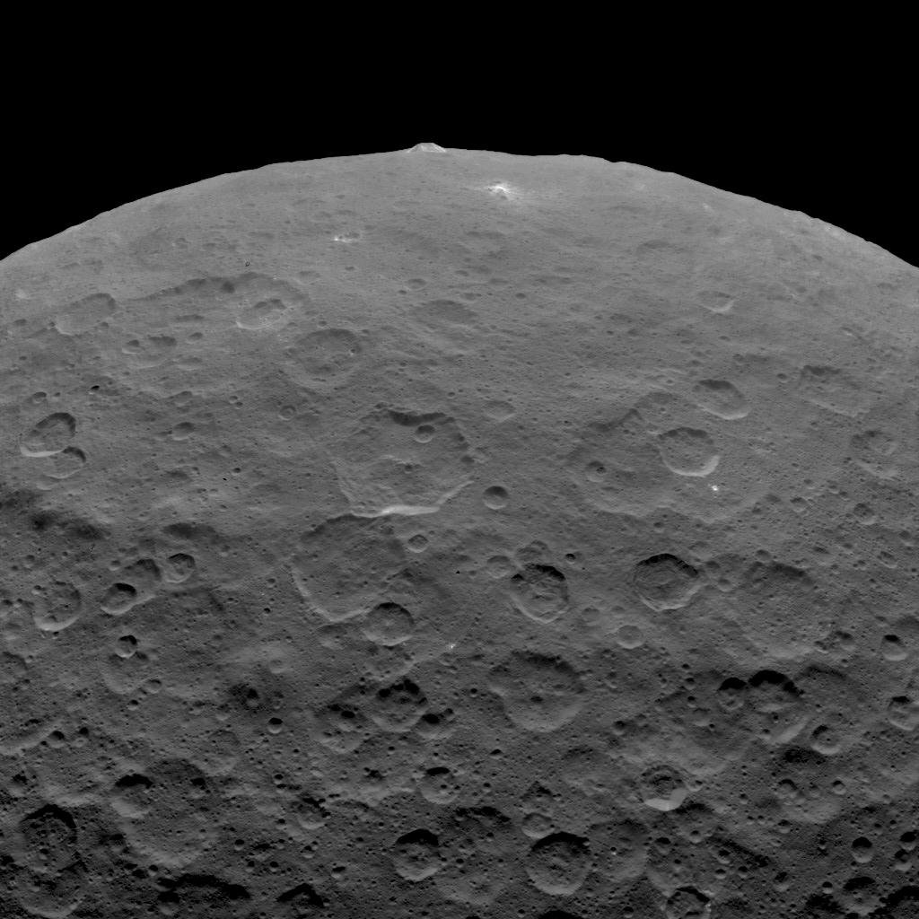
The 4 km high ice volcano Ahuna Mons (top) is visible projecting above the cratered surface of the dwarf planet Ceres. Image: By NASA/JPL-Caltech/UCLA/MPS/DLR/IDA
In science, one discovery often leads to more questions and mysteries. That’s certainly true of the ice volcanoes on the dwarf planet Ceres. When the Dawn spacecraft discovered the massive cryovolcano called Ahuna Mons on the surface of Ceres, it led to more questions: How cryovolcanically active is Ceres? And, why do we only see one?
Artist impression of the early Earth. Credit: NASA Goddard Space Flight Center Conceptual Image Lab
The question how life began on Earth has always been a matter of profound interest to scientists. But just as important as how life emerged is the question of when it emerged. In addition to discerning how non-living elements came together to form the first living organisms (a process known as abiogenesis), scientists have also sought to determine when the first living organisms appeared on Earth.
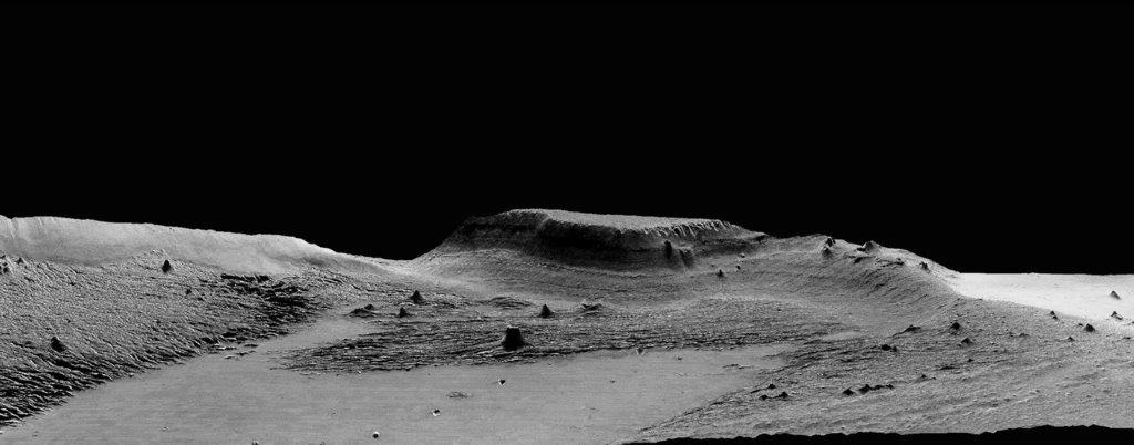
A 13-kilometer (8-mile) diameter crater being infilled by the Medusae Fossae Formation. Credit: High Resolution Stereo Camera/European Space Agency.
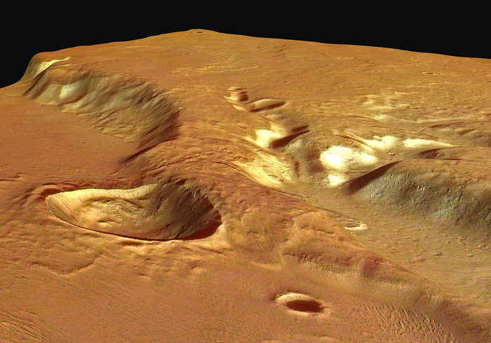
Scientists first observed the Medusae Fossae Formation (MFF) in the 1960s, thanks to the efforts of the Mariner spacecraft. This massive deposit of soft, sedimentary rock extends for roughly 1,000 km (621 mi) along the equator and consists of undulating hills, abrupt mesas, and curious ridges (aka. yardangs) that appear to be the result of wind erosion. What’s more, an unusual bump on top of this formation also gave rise to a UFO conspiracy theory.
Needless to say, the formation has been a source of scientific curiosity, with many geologists attempting to explain how it could have formed. According to a new study from Johns Hopkins University, the region was the result of volcanic activity that took place on the Red Planet more than 3 billion years ago. These findings could have drastic implications for scientists’ understanding of Mars’ interior and even its past potential for habitability.
Perspective view of Medusa Fossae looking south-east. Copyright: ESA/DLR/FU Berlin (G. Neukum)
Ojha’s past work includes finding evidence that water on Mars occurs in seasonal brine flows on the surface, which he discovered in 2010 as an undergraduate student. Lewis, meanwhile, has dedicated much of his academic carreer to the in-depth study of the nature of sedimentary rock on Mars for the sake of determining what this geological record can tell us about that planet’s past climate and habitability.
As Ojha explained, the study of the Medusa Fossae Formation is central to understanding Mars geological history. Much like the Tharsus Montes region, this formation was formed at a time when the planet was still geologically active. “This is a massive deposit, not only on a Martian scale, but also in terms of the solar system, because we do not know of any other deposit that is like this,” he said.
Basically, sedimentary rock is the result of rock dust and debris accumulating on a planet’s surface and becoming hardened and layered over time. These layers serve as a geological record, indicating what types of processes where taking place on the surface at the time that the layers were deposited. When it comes to the Medusae Fossae Formation, scientists were unsure whether wind, water, ice or volcanic eruptions were responsible for the deposits.
In the past, radar measurements were made of the formation that suggested that Medusae Fosssae had an unusual composition. However, scientists were unsure whether the formation was made of highly porous rock or a mixture of rock and ice. For the sake of their study, Ojha and Lewis used gravity data from various Mars orbiters to measure the formation’s density for the first time.
An isolated hill in the Medusae Fossae Formation. The effect of wind erosion on this hill is evident by its streamlined shape. Credit: High Resolution Stereo Camera/European Space Agency
What they found was that the rock is unusually porous and about two-thirds as dense as the rest of the Martian crust. They also used radar and gravity data to show that the Formation’s density was too great to be explained by the presence of ice. From this, they concluded that the heavily-porous rock had to have been deposited by volcanic eruptions when Mars was still geologically active – ca. 3 billion years ago.
As these volcanoes exploded, casting ash and rock into the atmosphere, the material would have then fallen back to the surface, building up layers and streaming down hills. After enough time, the ash would have cemented into rock, which was slowly eroded over time by Martian winds and dust storms, leaving the Formation scientists see there today. According to Ojha, these new findings suggest that Mars’ interior is more complex than previously thought.
While scientists have known for some time that Mars has some volatiles – i.e. water, carbon dioxide and other elements that become gas with slight increases in temperature – in its crust that allow for periodic explosive eruptions to occur on the surface, the kind of eruption needed to create the Medusa Fossae region would have been immense. This indicates that the planet may have massive amounts of volatiles in its interior. As Ojha explained:
“If you were to distribute the Medusae Fossae globally, it would make a 9.7-meter (32-foot) thick layer. Given the sheer magnitude of this deposit, it really is incredible because it implies that the magma was not only rich in volatiles and also that it had to be volatile-rich for long periods of time.”
According to Ojha and Lewis’ study, the eruption that created the Medusa Fossae Formation would have covered Mars in a global ocean. Image: ESO/M. Kornmesser, via N. Risinger
In addition, this activity would have had a drastic impact on Mars’ past habitability. Basically, the formation of the Medusae Fossae Formation would have occurred during a pivotal point in Mars’ history. After the eruption occurred, massive amounts of carbon dioxide and (most likely) methane would have been ejected into the atmosphere, causing a significant greenhouse effect.
In addition, the authors indicated that the eruption would have ejected enough water to cover Mars in a global ocean more than 9 cm (4 inches) in thickness. This resulting greenhouse effect would have been enough to keep Mars’ surface warm to the point that the water would remain in a liquid state. At the same time, the expulsion of volcanic gases like hydrogen sulfide and sulfur dioxide would have altered the chemistry of Mars’ surface and atmosphere.
All of this would have had a drastic impact on the planet’s potential habitability. What’s more, as Kevin Lewis indicated, the new study shows that gravity surveys have the potential to interpret Mars’ geological record. “Future gravity surveys could help distinguish between ice, sediments and igneous rocks in the upper crust of the planet,” he said.
Studying Mars surface features and geological history is a lot like peeling an onion. With every layer we peel back, we get another piece of the puzzle, which together adds up to a rich and varied history. In the coming years and decades, more robotic missions will be studying the Red Planet’s surface and atmosphere in preparation for an eventual crewed mission by the 2030s.
All of these missions will allow us to learn more about Mars warmer, wetter past and whether or not may have existed there at some time (or perhaps, still does!)
JunoCam took this image during its eleventh close flyby of Jupiter on February 7, 2018. Image credit: NASA / JPL / SwRI / MSSS / David Marriott.
It is a well-known fact among Earth scientists that our planet periodically undergoes major changes in its climate. Over the course of the past 200 million years, our planet has experienced four major geological periods (the Triassic, Jurassic and Cretaceous and Cenozoic) and one major ice age (the Pliocene-Quaternary glaciation), all of which had a drastic impact on plant and animal life, as well as effecting the course of species evolution.
For decades, geologists have also understood that these changes are due in part to gradual shifts in the Earth’s orbit, which are caused by Venus and Jupiter, and repeat regularly every 405,000 years. But it was not until recently that a team of geologists and Earth scientists unearthed the first evidence of these changes – sediments and rock core samples that provide a geological record of how and when these changes took place.
Professor Dennis Kent with part of a 1,700-foot-long rock core obtained from Petrified Forest National Park in Arizona. Credit: Nick Romanenko/Rutgers University
As noted, the idea that Earth experiences periodic changes in its climate (which are related to changes in its orbit) has been understood for almost a century. These changes consist of Milankovitch Cycles, which consist of a 100,000-year cycle in the eccentricity of Earth’s orbit, a 41,000-year cycle in the tilt of Earth’s axis relative to its orbital plane, and a 21,000-year cycle caused by changes in the planet’s axis.
Combined with the 405,000-year swing, which is the result of Venus and Jupiter’s gravitational influence, these shifts cause changes in how much solar energy reaches parts of our planet, which in turn influences Earth’s climate. Based on fossil records, these cycles are also known to have had a profound impact on life on Earth, which likely had an effect on the course of species of evolution. As Prof. Bent explained in a Rutgers Today press release:
“The climate cycles are directly related to how Earth orbits the sun and slight variations in sunlight reaching Earth lead to climate and ecological changes. The Earth’s orbit changes from close to perfectly circular to about 5 percent elongated especially every 405,000 years.”
For the sake of their study, Prof. Kent and his colleagues obtained sediment samples from the Newark basin, a prehistoric lake that spanned most of New Jersey, and a core rock sample from the Chinle Formation in Petrified Forest National Park in Arizona. This core rock measured about 518 meters (1700 feet) long, 6.35 cm (2.5 inches) in diameter, and was dated to the Triassic Period – ca. 202 to 253 million years ago.
Within ancient rocks in Arizona’s Petrified Forest National Park, scientists have identified signs of a regular variation in Earth’s orbit that influences climate. Credit: Kevin Krajick/Lamont-Doherty Earth Observatory
The team then linked reversals in Earth’s magnetic field – where the north and south pole shift – to sediments with and without zircons (minerals with uranium that allow for radioactive dating) as well as to climate cycles in the geological record. What these showed was that the 405,000-years cycle is the most regular astronomical pattern linked to Earth’s annual orbit around the Sun.
The results further indicated that the cycle been stable for hundreds of millions of years and is still active today. As Prof. Kent explained, this constitutes the first verifiable evidence that celestial mechanics have played a historic role in natural shifts in Earth’s climate. As Prof. Kent indicated:
“It’s an astonishing result because this long cycle, which had been predicted from planetary motions through about 50 million years ago, has been confirmed through at least 215 million years ago. Scientists can now link changes in the climate, environment, dinosaurs, mammals and fossils around the world to this 405,000-year cycle in a very precise way.”
Previously, astronomers were able to calculate this cycle reliably back to around 50 million years, but found that the problem became too complex prior to this because too many shifting motions came into play. “There are other, shorter, orbital cycles, but when you look into the past, it’s very difficult to know which one you’re dealing with at any one time, because they change over time,” said Prof. Kent. “The beauty of this one is that it stands alone. It doesn’t change. All the other ones move over it.”
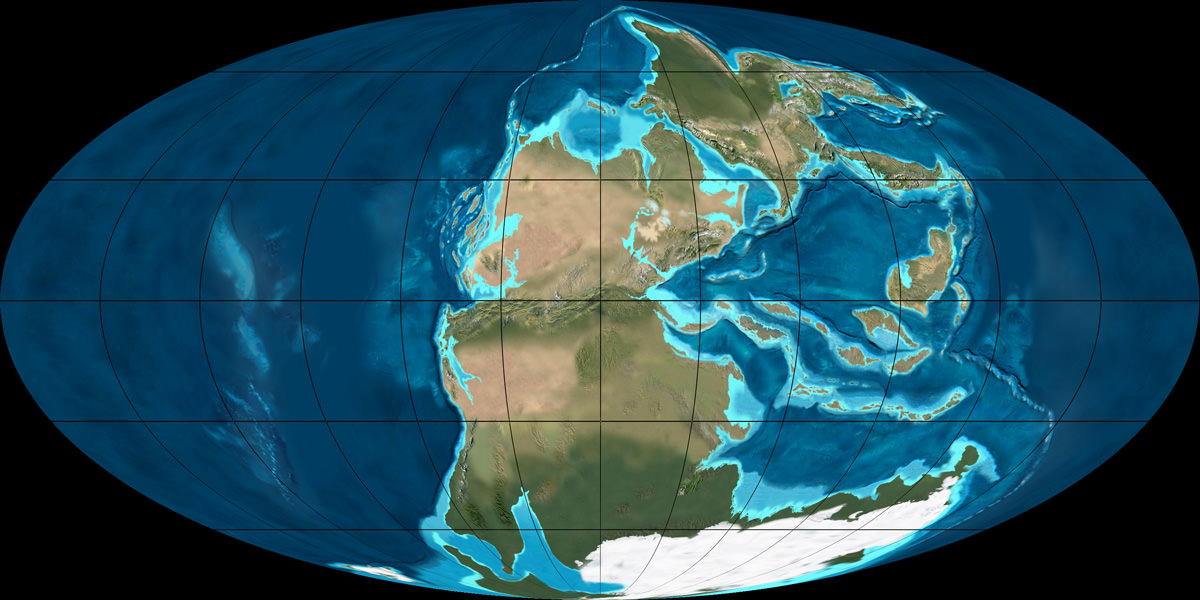
The super-continent Pangaea during the Permian period (300 – 250 million years ago). Credit: NAU Geology/Ron Blakey
In addition, scientists were unable to obtain accurate dates as to when Earth’s magnetic field reversed for 30 million years of the Late Triassic – between ca. 201.3 and 237 million years ago. This was a crucial period for the evolution of terrestrial life because it was when the Supercontinent of Pangaea broke up, and also when the dinosaurs and mammals first appeared.
This break-up led to the formation of the Atlantic Ocean as the continents drifted apart and coincided with a mass extinction event by the end of the period that effected the dinosaurs. With this new evidence, geologists, paleontologists and Earth scientists will be able to develop very precise timelines and accurately categorize fossil evidence dated to this period, which show differences and similarities over wide-ranging areas.
This research, and the ability to create accurate geological and climatological timelines that go back over 200 million years, is sure to have drastic implications. Not only will climate studies benefit from it, but also our understanding of how life, and even how our Solar System, evolved. What emerges from this could include a better understanding of how life could emerge in other star systems.
After all, if our search for extra-solar life life comes down to what we know about life on Earth, knowing more about how it evolved here will better the odds of finding it out there.
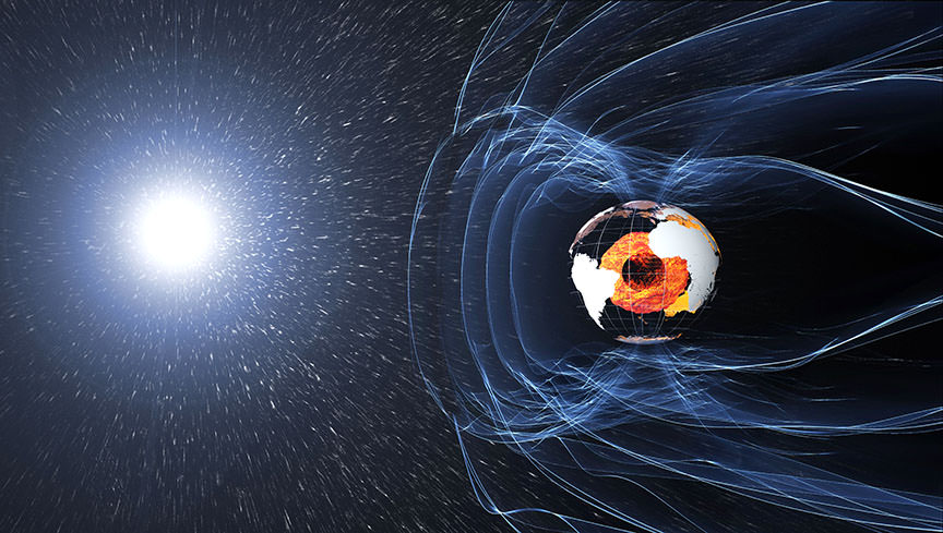
The magnetic field and electric currents in and around Earth generate complex forces that have immeasurable impact on every day life. Credit: ESA/ATG medialab
Earth’s magnetic field is one of the most mysterious features of our planet. It is also essential to life as we know it, ensuring that our atmosphere is not stripped away by solar wind and shielding life on Earth from harmful radiation. For some time, scientists have theorized that it is the result of a dynamo action in our core, where the liquid outer core revolves around the solid inner core and in the opposite direction of the Earth’s rotation.
In addition, Earth’s magnetic field is affected by other factors, such as magnetized rocks in the crust and the flow of the ocean. For this reason, the European Space Agency’s (ESA) Swarm satellites, which have been continually monitoring Earth’s magnetic field since its deployment, recently began monitoring Earth’s oceans – the first results of which were presented at this year’s European Geosciences Union meeting in Vienna, Austria.
The Swarm mission, which consists of three Earth-observation satellites, was launched in 2013 for the sake of providing high-precision and high-resolution measurements of Earth’s magnetic field. The purpose of this mission is not only to determine how Earth’s magnetic field is generated and changing, but also to allow us to learn more about Earth’s composition and interior processes.
Artist’s impression of the ESA’s Swarm satellites, which are designed to measure the magnetic signals from Earth’s core, mantle, crust, oceans, ionosphere and magnetosphere. Credit: ESA/AOES Medialab
Beyond this, another aim of the mission is to increase our knowledge of atmospheric processes and ocean circulation patterns that affect climate and weather. The ocean is also an important subject of study to the Swarm mission because of the small ways in which it contributes to Earth’s magnetic field. Basically, as the ocean’s salty water flows through Earth’s magnetic field, it generates an electric current that induces a magnetic signal.
Because this field is so small, it is extremely difficult to measure. However, the Swarm mission has managed to do just that in remarkable detail. These results, which were presented at the EGU 2018 meeting, were turned into an animation (shown below), which shows how the tidal magnetic signal changes over a 24 hour period.
As you can see, the animation shows temperature changes in the Earth’s oceans over the course of the day, shifting from north to south and ranging from deeper depths to shallower, coastal regions. These changes have a minute effect on Earth’s magnetic field, ranging from 2.5 to -2.5 microtesla. As Nils Olsen, from the Technical University of Denmark, explained in a ESA press release:
“We have used Swarm to measure the magnetic signals of tides from the ocean surface to the seabed, which gives us a truly global picture of how the ocean flows at all depths – and this is new. Since oceans absorb heat from the air, tracking how this heat is being distributed and stored, particularly at depth, is important for understanding our changing climate. In addition, because this tidal magnetic signal also induces a weak magnetic response deep under the seabed, these results will be used to learn more about the electrical properties of Earth’s lithosphere and upper mantle.”
By learning more about Earth’s magnetic field, scientists will able to learn more about Earth’s internal processes, which are essential to life as we know it. This, in turn, will allow us to learn more about the kinds of geological processes that have shaped other planets, as well as determining what other planets could be capable of supporting life.
Be sure to check out this comic that explains how the Swarm mission works, courtesy of the ESA.
Human activity is a major cause of air pollution, much of which results from industrial processes. Credit: cherwell.org
As a species, we humans tend to take it for granted that we are the only ones that live in sedentary communities, use tools, and alter our landscape to meet our needs. It is also a foregone conclusion that in the history of planet Earth, humans are the only species to develop machinery, automation, electricity, and mass communications – the hallmarks of industrial civilization.
But what if another industrial civilization existed on Earth millions of years ago? Would we be able to find evidence of it within the geological record today? By examining the impact human industrial civilization has had on Earth, a pair of researchers conducted a study that considers how such a civilization could be found and how this could have implications in the search for extra-terrestrial life.
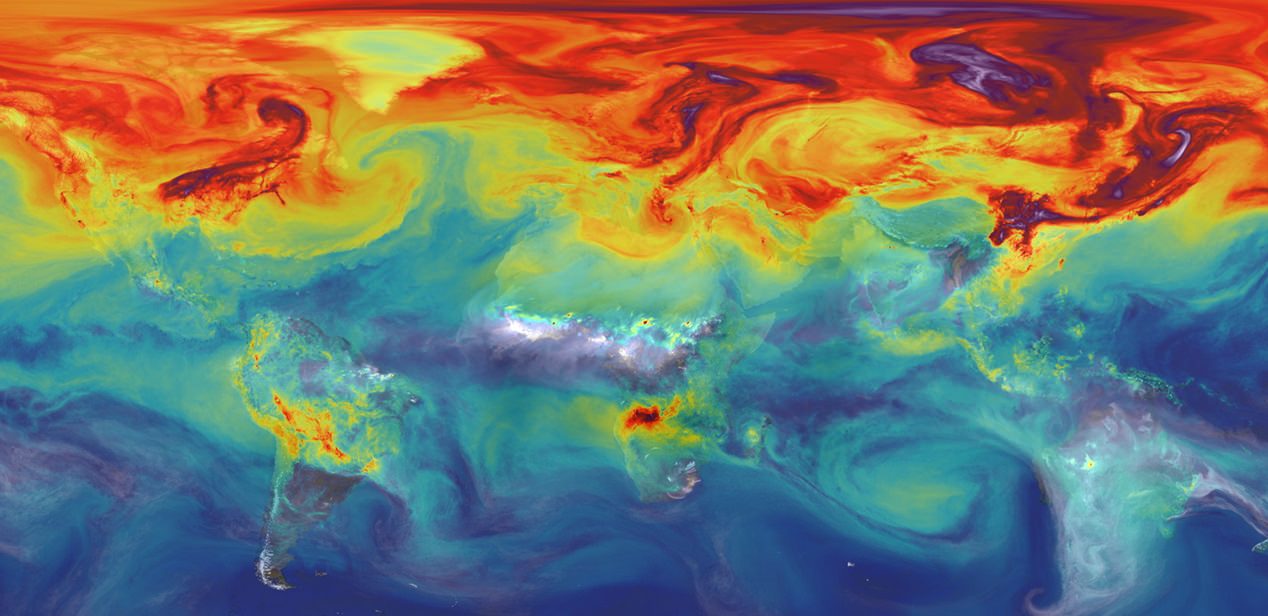
Carbon dioxide in Earth’s atmosphere if half of global-warming emissions are not absorbed. Credit: NASA/JPL/GSFC
As they indicate in their study, the search for life on other planets has often involved looking to Earth-analogues to see what kind conditions life could exist under. However, this pursuit also entails the search for extra-terrestrial intelligence (SETI) that would be capable of communicating with us. Naturally, it is assumed that any such civilization would need to develop and industrial base first.
This, in turn, raises the question of how often an industrial civilization might develop – what Schmidt and Frank refer to as the “Silurian Hypothesis”. Naturally, this raises some complications since humanity is the only example of an industrialized species that we know of. In addition, humanity has only been an industrial civilization for the past few centuries – a mere fraction of its existence as a species and a tiny fraction of the time that complex life has existed on Earth.
For the sake of their study, the team first noted the importance of this question to the Drake Equation. To recap, this theory states that the number of civilizations (N) in our galaxy that we might be able to communicate is equal to the average rate of star formation (R*), the fraction of those stars that have planets (fp), the number of planets that can support life (ne), the number of planets that will develop life ( fl), the number of planets that will develop intelligent life (fi), the number civilizations that would develop transmission technologies (fc), and the length of time these civilizations will have to transmit signals into space (L).
This can be expressed mathematically as: N = R* x fp x ne x fl x fi x fc x L
The Drake Equation, a mathematical formula for the probability of finding life or advanced civilizations in the universe. Credit: University of Rochester
As they indicate in their study, the parameters of this equation may change thanks to the addition of the Silurian Hypothesis, as well as recent exoplanets surveys:
“If over the course of a planet’s existence, multiple industrial civilizations can arise over the span of time that life exists at all, the value of fc may in fact be greater than one. This is a particularly cogent issue in light of recent developments in astrobiology in which the first three terms, which all involve purely astronomical observations, have now been fully determined. It is now apparent that most stars harbor families of planets. Indeed, many of those planets will be in the star’s habitable zones.”
In short, thanks to improvements in instrumentation and methodology, scientists have been able to determine the rate at which stars form in our galaxy. Furthermore, recent surveys for extra-solar planets have led some astronomers to estimate that our galaxy could contains as many as 100 billion potentially-habitable planets. If evidence could be found of another civilization in Earth’s history, it would further constrain the Drake Equation.
They then address the likely geologic consequences of human industrial civilization and then compare that fingerprint to potentially similar events in the geologic record. These include the release of isotope anomalies of carbon, oxygen, hydrogen and nitrogen, which are a result of greenhouse gas emissions and nitrogen fertilizers. As they indicate in their study:
“Since the mid-18th Century, humans have released over 0.5 trillion tons of fossil carbon via the burning of coal, oil and natural gas, at a rate orders of magnitude faster than natural long-term sources or sinks. In addition, there has been widespread deforestation and addition of carbon dioxide into the air via biomass burning.”
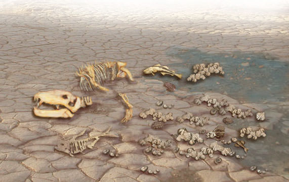
Based on fossil records, 250 million years ago over 90% of all species on Earth died out, effectively resetting evolution. Credit: Lunar and Planetary Institute
They also consider increased rates of sediment flow in rivers and its deposition in coastal environments, as a result of agricultural processes, deforestation, and the digging of canals. The spread of domesticated animals, rodents and other small animals are also considered – as are the extinction of certain species of animals – as a direct result of industrialization and the growth of cities.
The presence of synthetic materials, plastics, and radioactive elements (caused by nuclear power or nuclear testing) will also leave a mark on the geological record – in the case of radioactive isotopes, sometimes for millions of years. Finally, they compare past extinction level events to determine how they would compare to a hypothetical event where human civilization collapsed. As they state:
“The clearest class of event with such similarities are the hyperthermals, most notably the Paleocene-Eocene Thermal Maximum (56 Ma), but this also includes smaller hyperthermal events, ocean anoxic events in the Cretaceous and Jurassic, and significant (if less well characterized) events of the Paleozoic.”
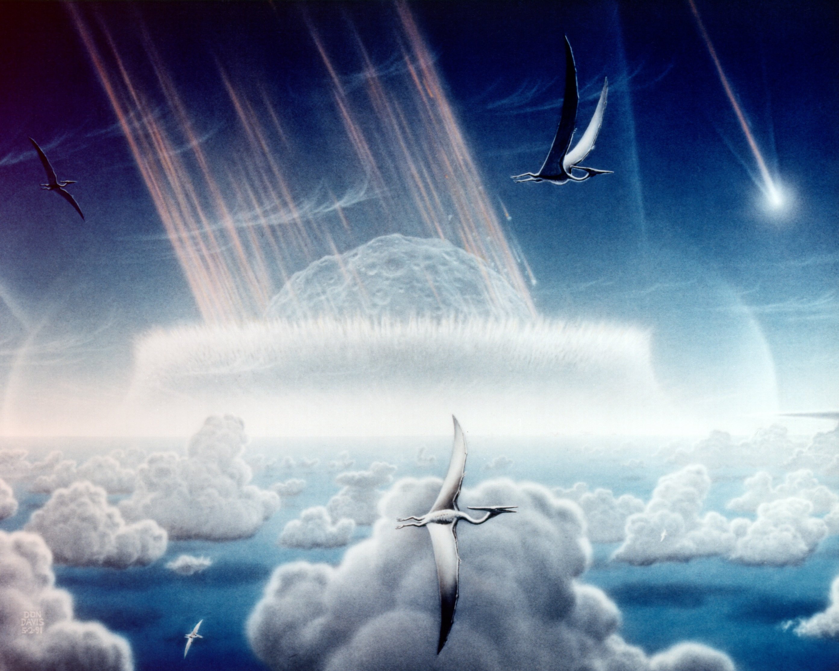
These events were specifically considered because they coincided with rises in temperatures, increases in carbon and oxygen isotopes, increased sediment, and depletions of oceanic oxygen. Events that had a very clear and distinct cause, such as the Cretaceous-Paleogene extinction event (caused by an asteroid impact and massive volcanism) or the Eocene-Oligocene boundary (the onset of Antarctic glaciation) were not considered.
Artistic rendition of the Chicxulub impactor striking ancient Earth, with Pterosaur observing. Credit: NASA
According to the team, the events they did consider (known as “hyperthermals”) show similarities to the Anthropocene fingerprint that they identified. In particular, according to research cited by the authors, the Paleocene-Eocene Thermal Maximum (PETM) shows signs that could be consistent with anthorpogenic climate change. These include:
“[A] fascinating sequence of events lasting 100–200 kyr and involving a rapid input (in perhaps less than 5 kyr) of exogenous carbon into the system, possibly related to the intrusion of the North American Igneous Province into organic sediments. Temperatures rose 5–7?C (derived from multiple proxies), and there was a negative spike in carbon isotopes (>3%), and decreased ocean carbonate preservation in the upper ocean.”
Finally, the team addressed some possible research directions that might improve the constraints on this question. This, they claim, could consist of a “deeper exploration of elemental and compositional anomalies in extant sediments spanning previous events be performed”. In other words, the geological record for these extinction events should be examined more closely for anomalies that could be associated with industrial civilization.
If any anomalies are found, they further recommend that the fossil record could be examined for candidate species, which would raise questions about their ultimate fate. Of course, they also acknowledge that more evidence is necessary before the Silurian Hypothesis can be considered viable. For instance, many past events where abrupt Climate Change took place have been linked to changes in volcanic/tectonic activity.
Scientists were able to gauge the rate of water loss on Mars by measuring the ratio of water and HDO from today and 4.3 billion years ago. Credit: Kevin Gill
Second, there is the fact that current changes in our climate are happening faster than in any other geological period. However, this is difficult to say for certain since there are limits when it comes to the chronology of the geological record. In the end, more research will be necessary to determine how long previous extinction events (those that were not due to impacts) took as well.
Beyond Earth, this study may also have implications for the study of past life on planets like Mars and Venus. Here too, the authors suggest how explorations of both could reveal the existence of past civilizations, and maybe even bolster the possibility of finding evidence of past civilizations on Earth.
“We note here that abundant evidence exists of surface water in ancient Martian climates (3.8 Ga), and speculation that early Venus (2 Ga to 0.7 Ga) was habitable (due to a dimmer sun and lower CO2 atmosphere) has been supported by recent modeling studies,” they state. “Conceivably, deep drilling operations could be carried out on either planet in future to assess their geological history. This would constrain consideration of what the fingerprint might be of life, and even organized civilization.”
Two key aspects of the Drake Equation, which addresses the probability of finding life elsewhere in the galaxy, are the sheer number of stars and planets out there and the amount of time life has had to evolve. Until now, it has been assumed that one planet would give rise to one intelligent species capable of advanced technology and communications.
But if this number should prove to be more, we may a find a galaxy filled with civilizations, both past and present. And who knows? The remains of a once advanced and great non-human civilization may very well be right beneath us!
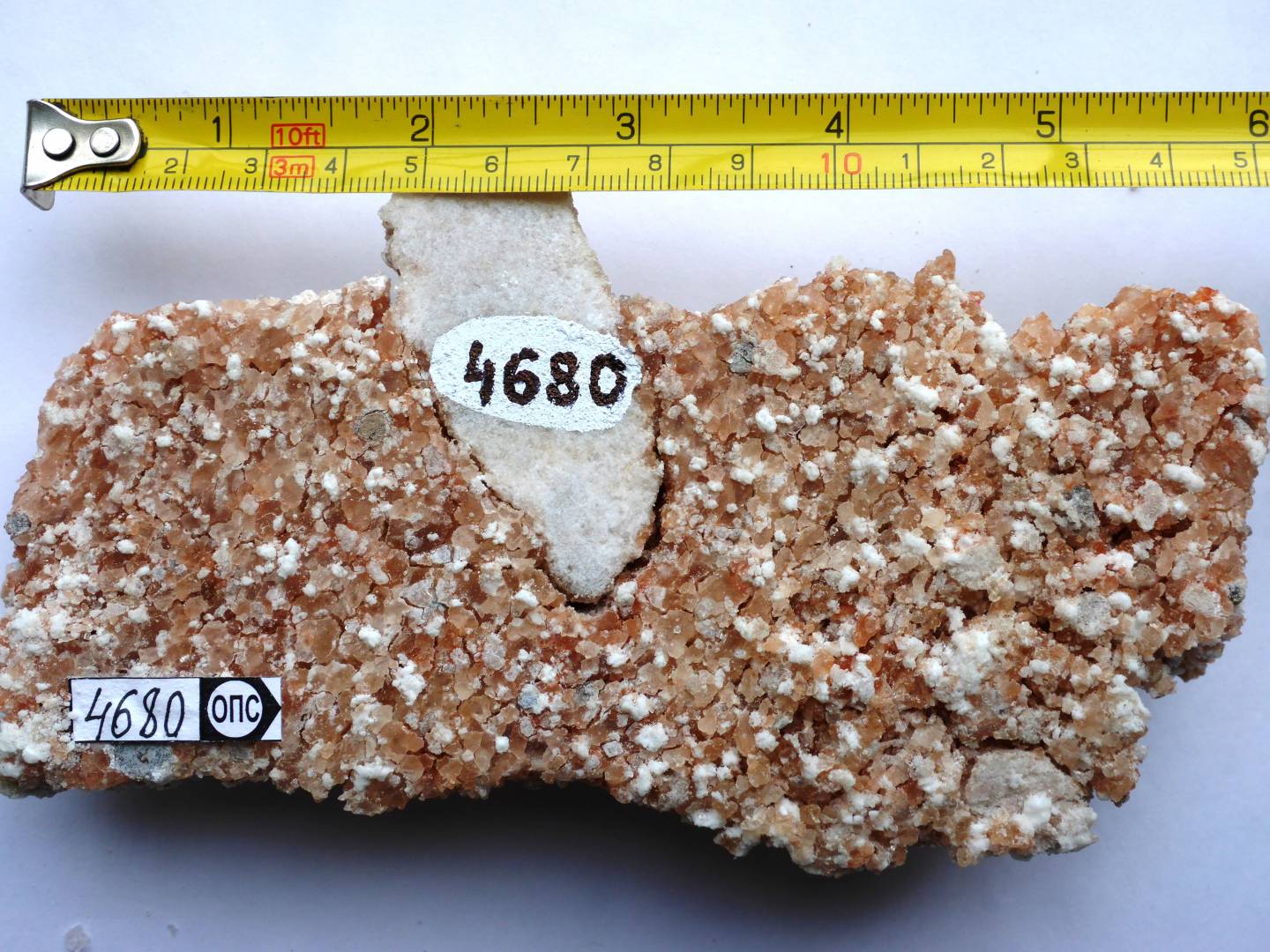
Salts left over from ancient seawater reveal new information about the oxygenation of the Earth’s atmosphere more than 2 billion years ago. Shown here is a sample of 2-billion-year-old salt (pink-white recrystallized halite) with embedded fragments of calcium sulfate from a geological drill core in Russian Karelia. Credit: Aivo Lepland, Geological Survey of Norway; courtesy of Science/AAAS
Billions of years ago, Earth’s environment was very different from the one we know today. Basically, our planet’s primordial atmosphere was toxic to life as we know it, consisting of carbon dioxide, nitrogen and other gases. However, by the Paleoproterozoic Era (2.5–1.6 billion years ago), a dramatic change occurred where oxygen began to be introduced to the atmosphere – known as the Great Oxidation Event (GOE).
Until recently, scientists were not sure if this event – which was the result of photosynthetic bacteria altering the atmosphere – occurred rapidly or not. However, according to a recent study by a team of international scientists, this event was much more rapid than previously thought. Based on newly-discovered geological evidence, the team concluded that the introduction of oxygen to our atmosphere was “more like a fire hose” than a trickle.
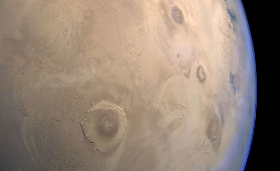
Image of the Tharsis region of Mars taken by Mars Express featuring several prominent shield volcanoes includes the massive Olympus Mons (at left). Credit: ESA
Thanks to the many missions that have been studying Mars in recent years, scientists are aware that roughly 4 billion years ago, the planet was a much different place. In addition to having a denser atmosphere, Mars was also a warmer and wetter place, with liquid water covering much of the planet’s surface. Unfortunately, as Mars lost its atmosphere over the course of hundreds of millions of years, these oceans gradually disappeared.
When and where these oceans formed has been the subject of much scientific inquiry and debate. According to a new study by a team of researchers from UC Berkeley, the existence of these oceans was linked to the rise of the Tharis volcanic system. They further theorize that these oceans formed several hundred millions years earlier than expected and were not as deep as previously thought.
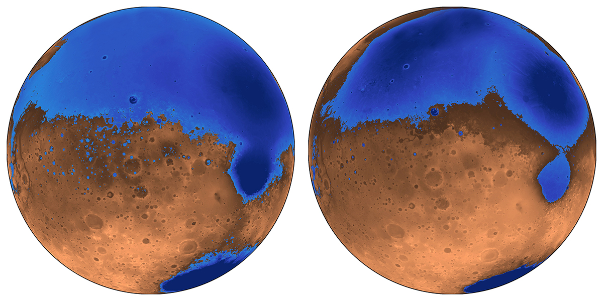
The early ocean known as Arabia (left, blue) would have looked like this when it formed 4 billion years ago on Mars, while the Deuteronilus ocean (right), about 3.6 billion years old, had a smaller shoreline. Credit: Robert Citron/UC Berkeley
As Michael Manga explained in a recent Berkeley News press release:
“The assumption was that Tharsis formed quickly and early, rather than gradually, and that the oceans came later. We’re saying that the oceans predate and accompany the lava outpourings that made Tharsis.”
The debate over the size and extent of Mars’ past oceans is due to some inconsistencies that have been observed. Essentially, when Mars lost its atmosphere, its surface water would have frozen to become underground permafrost or escaped into space. Those scientists who don’t believe Mars once had oceans point to the fact that the estimates of how much water could have been hidden away or lost is not consistent with estimates on the oceans’ sizes.
What’s more, the ice that is now concentrated in the polar caps is not enough to create an ocean. This means that either less water was present on Mars than previous estimates indicate, or that some other process was responsible for water loss. To resolve this, Citron and his colleagues created a new model of Mars where the oceans formed before or at the same time as Mars’ largest volcanic feature – Tharsis Montes, roughly 3.7 billion years ago.
A colorized image of the surface of Mars taken by the Mars Reconnaissance Orbiter. The line of three volcanoes is the Tharsis Montes, with Olympus Mons to the northwest. Valles Marineris is to the east. Image: NASA/JPL-Caltech/ Arizona State University
Since Tharsis was smaller at the time, it did not cause the same level of crustal deformation that it did later. This would have been especially true of the plains that cover most the northern hemisphere and are believed to have been an ancient seabed. Given that this region was not subject to the same geological change that would have come later, it would have been shallower and held about half the water.
“The assumption was that Tharsis formed quickly and early, rather than gradually, and that the oceans came later,” said Manga. “We’re saying that the oceans predate and accompany the lava outpourings that made Tharsis.”
In addition, the team also theorized that the volcanic activity that created Tharsis may have been responsible for the formation of Mars’ early oceans. Basically, the volcanoes would have spewed gases and volcanic ash into the atmosphere that would have led to a greenhouse effect. This would have warmed the surface to the point that liquid water could form, and also created underground channels that allowed water to reach the northern plains.
Their model also counters other previous assumptions about Mars, which are that its proposed shorelines are very irregular. Essentially, what is assumed to have been “water front” property on ancient Mars varies in height by as much as a kilometer; whereas on Earth, shorelines are level. This too can be explained by the growth of the Tharsis volcanic region, roughly 3.7 billion years ago.
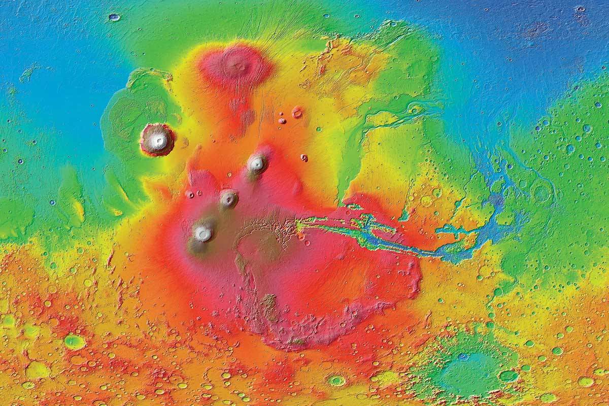
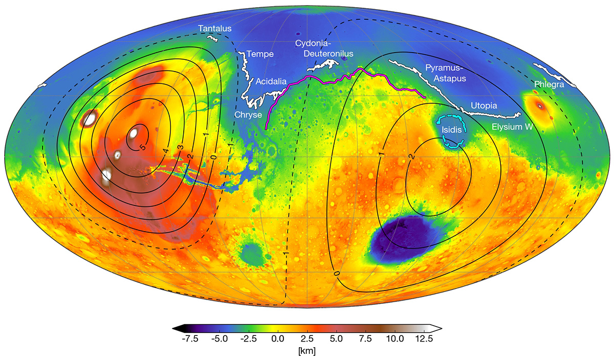
A map of Mars today shows where scientists have identified possible ancient shoreline that may have been etched by intermittent oceans billions of years ago. Credit: Robert Citron/UC Berkeley.
Using current geological data of Mars, the team was able to trace how the irregularities we see today could have formed over time. This would have began when Mars first ocean (Arabia) started forming 4 billion years ago and was around to witness the first 20% of Tharsis Montes growth. As the volcanoes grew, the land became depressed and the shoreline shifted over time.
Similarly, the irregular shorelines of a subsequent ocean (Deuteronilus) can be explained by this model by indicating that it formed during the last 17% of Tharsis’ growth – roughly 3.6 billion years ago. The Isidis feature, which appears to be an ancient lakebed slightly removed from the Utopia shoreline, could also be explained this way. As the ground deformed, Isidis ceased being part of the northern ocean and became a connected lakebed.
“These shorelines could have been emplaced by a large body of liquid water that existed before and during the emplacement of Tharsis, instead of afterwards,” said Citron. This is certainly consistent with the observable effect that Tharsis Mons has had on the topography of Mars. It’s bulk not only creates a bulge on the opposite side of the planet (the Elysium volcanic complex), but a massive canyon system in between (Valles Marineris).
This new theory not only explains why previous estimates about the volume of water in the northern plains were inaccurate, it can also account for the valley networks (cut by flowing water) that appeared around the same time. And in the coming years, this theory can be tested by the robotic missions NASA and other space agencies are sending to Mars.
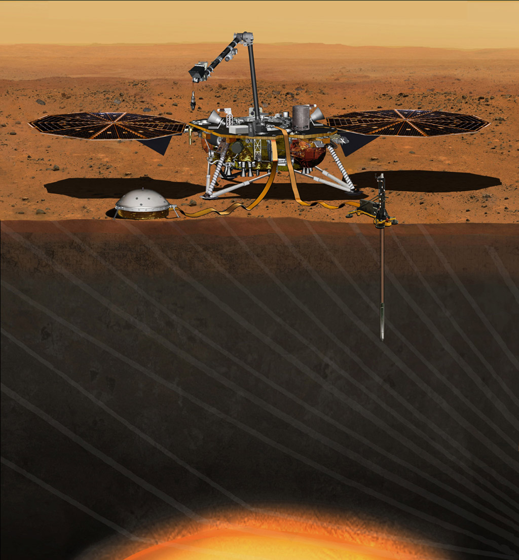
This artist’s concept from August 2015 depicts NASA’s InSight Mars lander fully deployed for studying the deep interior of Mars. Credit: NASA/JPL-Caltech
Consider NASA’s Interior Exploration using Seismic Investigations, Geodesy and Heat Transport (InSight) mission, which is scheduled for launch in May, 2018. Once it reaches Mars, this lander will use a suite of advanced instruments – which includes a seismometer, temperature probe and radio science instrument – to measure Mars interior and learn more about its geological activity and history.
Among other things, NASA anticipates that InSight might detect the remains of Mars’ ancient ocean frozen in the interior, and possibly even liquid water. Alongside the Mars 2020 rover, the ExoMars 2020, and eventual crewed missions, these efforts are expected to provide a more complete picture of Mars past, which will include when major geological events took place and how this could have affected the planet’s ocean and shorelines.
The more we learn about what happened on Mars over the past 4 billion years, the more we learn about the forces that shaped our Solar System. These studies also go a long way towards helping scientists determine how and where life-bearing conditions can form. This (we hope) will help us locate life it in another star system someday!
The intricate 3D map of the La Cueva de Los Verdes lava tube system in Lanzarote, Spain. Credit: Vigea – Tommaso Santagata
For some time, scientists have known that the Moon and Mars have some fascinating similarities to Earth. In addition to being similar in composition, there is ample evidence that both bodies had active geological pasts. This includes stable lava tubes which are very similar to those that exist here on Earth. And in the future, these tubes could be an ideal location for outposts and colonies.
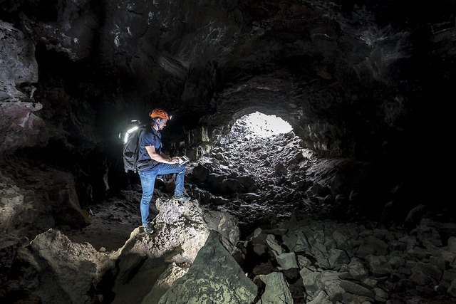
However, before we can begin choosing where to settle, these locations need to be mapped out to determining which would be suitable for human habitation. Luckily, a team of speleologists (cave specialists), geologists and ESA astronauts recently created the largest 3D image of a lava tube ever created. As part of the ESA’s PANGAEA program, this technology could one day help scientists map out cave systems on the Moon and Mars.
The lava tube in question was the La Cueva de Los Verdes, a famous tourist destination in Lanzarote, Spain. In addition to ESA astronaut Matthias Mauer, the team consisted of Tommaso Santagata (a speleologist from the University of Padova and the co-founder of the Virtual Geographic Agency), Umberto Del Vecchio and Marta Lazzaroni – a geologists and a masters student from the University of Padova, respectively.
Testing out the Leica BLK360 in La Cueva de los Verdes lava tube in Lanzarote, Spain. Credit and Copyright: ESA – Alessio Romeo
For five days in November 2017, this campaign mobilized 50 people, four space agencies and 18 organizations in five different locations. The La Cueva de los Verdes lava tube was of particular importance since it is one of the world’s largest volcanic cave complexes, measuring roughly 8 km in length. Some of these caves are even large enough to accommodate residential streets and houses.
During the campaign, Mauer, Santagata, Vecchio and Lazzaroni relied on two instruments to map the lava tube in detail. These included the Pegasus Backpack, a wearable mapping solution that collects geometric data without a satellite ad synchronizes images collected by five cameras and two 3D imaging laser profilers, and the Leica BLK360 – the smallest and lightest imaging scanner on the market.
In less than three hours, the team managed to map all the contours of the lava tube. And while the results of the campaign continue to be analyzed, the team chose to use the data they obtained to produce a 3D visual of all the twists and turns of the lava tube. The scan that resulted covers a 1.3 km section of the cave system with an unprecedented resolution of a few centimeters.
Santagata and the Virtual Geography Agency also turned their 3D visual into a lovely video titled “Lave tube fly-through”, which beautifully illustrates the winding and organic nature of the lava tube system. This video was posted to the ESA’s twitter feed on Tuesday, March 13th (shown above). This video, like the scans that preceded it, represent a breakthrough in geological mapping and astronaut training.
While lava tubes have been mapped since the 1970s, a clear view of this subterranean passage has remained elusive until now. Beyond being the first, the scans the team conducted could also help scientists to study the origins of the cave system, its peculiar formations, and assist local institutions in protecting the subterranean environment. As intended, the scans could also assist future space exploration and colonization efforts.
Pangaea-X arrives at the entrance to La Cueva de los Verdes lava tube. Credit and Copyright: ESA–Robbie Shone
For instance, the 8 km lava tube has both dry and water-filled sections. In the six-kilometer dry section, the lava tube has natural openings (jameos), that are aligned along the top of the cave pathway. These formations are very similar to “skylights” that have been observed on the Moon and Mars, which are holes in the surface that open into stable lava tubes.
Such structures are considered to be a good place for building outposts and colonies since they are naturally shielded from radiation and micrometeorites. Lava tubes also have a constant temperature, therefore offering protection against environmental extremes, and could provide access to underground sources of water ice. Some sections could also be sealed off and pressurized to create a colony.
As such, exploring such environments here on Earth is a good way to train astronauts to explore them on other bodies. As all astronauts know, mapping an environment is the first step in exploration, especially when you are looking for a place to establish a base camp. And in time, this information can be used to establish more permanent settlements, giving rise to eventual colonization.