What is the Highest Place on Earth?

Mt. Chimborazo, located in Equator, is technically the highest point on Earth. Sorry, Everest! Credit: gerdbreitenbach.de

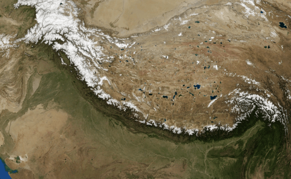
Whenever the question is asked, what is the highest point on planet Earth?, people naturally assume that the answer is Mt. Everest. In fact, so embedded is the notion that Mt. Everest is the highest point on the world that most people wouldn’t even think twice before answering. And even when we talk of other huge mountains in the Solar System (like Mars’ Olympus Mons), we invariably compare them to Mt. Everest.

But in truth, Everest does not hold the record for being the highest point on Earth. Due to the nature of our planet – which is not shaped like a perfect sphere but an oblate spheroid (i.e. a sphere that bulges at the center) – points that are located along the equator are farther away than those located at the poles. When you factor this in, Everest and the Himalayas find themselves falling a bit short!

Earth as a Sphere:

The understanding that Earth is spherical is believed to have emerged during the 6th century BCE in ancient Greece. While Pythagoras is generally credited with this theory, it is equally likely that it emerged on its own as a result of travel between Greek settlements – where sailors noticed changes in what stars were visible at night based on differences in latitudes.

Earth - Western Hemisphere
Planet Earth, as seen from space above the Western Hemisphere. Credit: Reuters

By the 3rd century BCE, the idea of a spherical Earth began to become articulated as a scientific matter. By measuring the angle cast by shadows in different geographical locations, Eratosthenes – a Greek astronomer from Hellenistic Libya (276–194 BCE) – was able to estimate Earth’s circumference within a 5% – 15% margin of error. With the rise of the Roman Empire and their adoption of Hellenistic astronomy, the view of a spherical Earth became widespread throughout the Mediterranean and Europe.

This knowledge was preserved thanks to the monastic tradition and Scholasticism during the Middle Ages. By the Renaissance and the Scientific Revolution (mid 16th – late 18th centuries), the geological and heliocentric views of Earth became accepted as well. With the advent of modern astronomy, precise methods of measurement, and the ability to view Earth from space, our models of its true shape and dimensions have come to be refined considerably.

Modern Models of the Earth:

To clarify matters a little, the Earth is neither a perfect sphere, nor is it flat. Sorry Galileo, and sorry Flat-Earthers (not sorry!), but it’s true. As already noted, it is an oblate spheroid, which is a result of the rotation of the Earth. Basically, its spin results in a flattening at the poles and a bulging at its equatorial. This is true for many bodies in the Solar System (such as Jupiter and Saturn) and even rapidly-spinning stars like Altair.

Data from the Earth2014 global relief model, with distances in distance from the geocentre denoted by color. Credit: Geodesy2000
Data from the Earth2014 global relief model, with distances from the geocenter represented in color. Credit: Geodesy2000

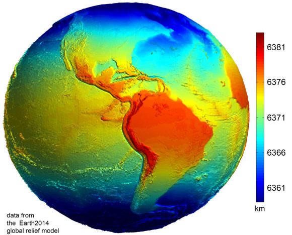
Based on some of the latest measurements, it is estimated that Earth has a polar radius (i.e. from the middle of Earth to the poles) of 6,356.8 km, whereas its equatorial radius (from the center to the equator) is 6,378.1 km. In short, objects located along the equator are 22 km further away from the center of the Earth (geocenter) than objects located at the poles.

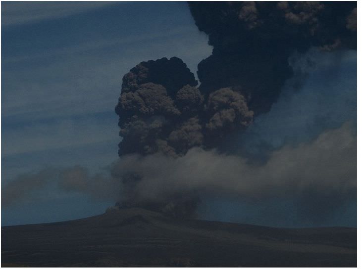
Naturally, there are some deviations in the local topography where objects located away from the equator are closer or father away from the center of the Earth than others in the same region. The most notable exceptions are the Mariana Trench – the deepest place on Earth, at 10,911 m (35,797 ft) below local sea level – and Mt. Everest, which is 8,848 meters (29,029 ft) above local sea level. However, these two geological features represent a very minor variation when compared to Earth’s overall shape – 0.17% and 0.14% respectively.

Highest Point on Earth:

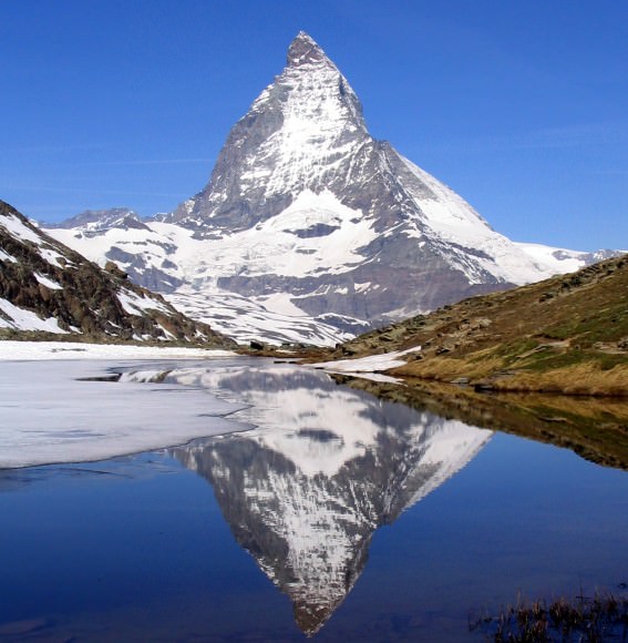
To be fair, Mt. Everest is one of the highest points on Earth, with its peak ascending to an altitude of 8,848 meters (29,029 ft) above sea level. However, due to its location within the Himalayan Mountain Chain in Nepal, some 27° and 59 minutes north of the equator, it is actually lower than mountains located in Ecuador.

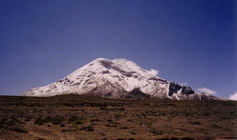
It is here, where the land is dominated by the Andes mountain chain, that the highest point on planet Earth is located. Known as Mt. Chiborazo, the peak of this mountain reaches an attitude of 6,263.47 meters (20,549.54 ft) above sea level. But because it is located just 1° and 28 minutes south of the equator (at the highest point of the planet’s bulge), it receives a natural boost of about 21 km.

Mount Everest from Kalapatthar. Photo: Pavel Novak
Mount Everest, imaged from Kalapatthar. Credit: Pavel Novak

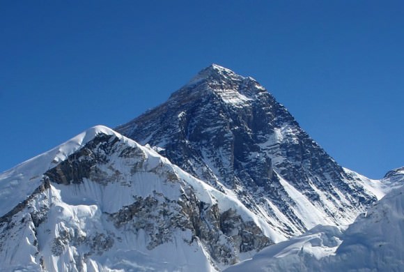
In terms of how far they are from the geocenter, Everest lies at a distance of 6,382.3 kilometers (3,965.8 miles) from the center of the Earth while Chimborazo reaches to a distance of 6,384.4 kilometers (3,967.1 miles). That’s a difference of about 2.1 km (1.3 miles), which may not seem like much. But if we’re talking about rankings and titles, it pays to be specific.

Naturally, there are those who would stress that Mt. Everest is still the tallest mountain, measured from base to peak. Unfortunately, here too, they would be incorrect. That prize goes to Mauna Kea, a dormant volcano located on the island of Hawaii. Measuring 10,206 meters (33,484 ft) from base to summit, it is the highest mountain in the world. However, since its base is several thousand meters below seat level, we only see the top 4,207 m (13,802 ft) of it.

But if one were to say that Everest was tallest mountain based on its altitude, they would be correct. In terms of its summit’s elevation above sea level, Everest is ranked as being as the tallest mountain in the world. And when it comes to the sheer difficulty of ascending it, Everest will always be ranked no. 1, both in the records books and in the hearts of climbers everywhere!

We have written many interesting articles about the Earth and mountains here at Universe Today. Here’s Planet Earth, What is the Earth’s Diameter?, The Rotation of the Earth, and Mountains: How Are They Formed?

For more information, be sure to check out NASA’s Visible Earth, and “Highest Mountain in the World” at Geology.com.

Astronomy Cast also has a great episode on the subject – Episode 51: Earth.

Massive 400 Ft. Tsunamis On Ancient Mars

An artist's impression of the ancient Martian ocean. When two meteors slammed into Mars 3.4 billion years ago, they triggered massive, 400 ft. tsunamis that reshaped the coastline. Image: ESO/M. Kornmesser, via N. Risinger

About 3.4 billion years ago, (according to a new study) when the Late Heavy Bombardment had ended, and the first cells resembling prokaryotes were appearing on Earth, two enormous meteoroids slammed into the ancient, frigid ocean on Mars. These impacts generated massive 400 ft. high tsunamis that reshaped the shoreline of the Martian ocean, leaving behind fields of sediments and boulders.

It was long thought that ancient Mars had oceans. Sedimentary deposits discovered in the Martian north by radar in 2012 helped make the case for Martian oceans. 3.4 billion years ago, this ocean covered most of the Northern Martian lowlands. It’s thought that the ocean itself was fed by catastrophic flooding, perhaps fuelled by geothermal activity on Mars at the time.

These catastrophic tsunamis would have dwarfed most Earthly disasters. Waves 120 meters high would have swamped landmarks like the Statue of Liberty (93 m. high), and caused enormous destruction along the Martian coastline. If the research behind this new study stands up to scrutiny, then it will help prove the existence of the ancient Martian ocean.

The blue area in the above image is thought to be the location of a primordial ocean Mars. Image: NASA/JPL-Caltech/GSFC - Public Domain
The blue area in the above image is thought to be the location of a primordial ocean Mars. Image: NASA/JPL-Caltech/GSFC – Public Domain

The Martian surface shows the remains of an ancient ocean. In some areas, radar data shows a layer of water-borne sediment on top of a layer of volcanic rock. There’s also evidence of a shoreline, described by some scientists as being like a bathtub ring. The problems is, the shoreline can’t be seen everywhere it should be.

The tsunami hypothesis helps explain this missing shoreline.

According to the new study, led by Alexis Rodriguez, a Mars researcher at the Planetary Science Institute in Tucson Arizona, the tsunamis would have wiped away portions of the coastline, and left behind fields of sediment and boulders, and large backwash channels cut into the Martian surface.

The study is focussed on a specific region on Mars where a highland feature called Arabia Terra abuts the Chryse Planitia lowlands. This area was part of the shoreline of the Martian ocean. In that area, the team behind the study identified two separate geological formations that they say were created by two separate tsunami events.

The top image shows the shoreline of the ancient Martian shoreline at two separate times. The bottom images show debris left behind by the two tsunamis.  Image: Alexis Rodriguez.
The top image shows the shoreline of the ancient Martian shoreline at two separate times. The bottom images show debris left behind by the two tsunamis. Image: Alexis Rodriguez.

The first formation, and older of the two, looks every bit like a disturbed shoreline. An enormous wave washed over the beach, and in its wake deposited boulders over 10 meters across. Then, as the water drained back down into the ocean, it cut large backwash channels through its debris and boulder field.

A sequence of zoomed in images of the Martian surface in the study. A shows distances and elevations of backwash channels. B shows some of the channel-scoured, north-sloping highland mesas in blue. C shows the channelled surface, and D shows them in closer detail. Finally, E is zoomed in to show boulders as much as 10 m. in diameter. (Yellow bars are 10m.) Image: A,B:MOLA Science Team, MSS, JPL, NASA. C,D,E:  NASA/JPL/University of Arizona
A sequence of zoomed in images of the Martian surface in the study. (A) shows distances and elevations of backwash channels. (B) shows some of the channel-scoured, north-sloping highland mesas in blue. (C) shows the channelled surface, and (D) shows them in closer detail. Finally, (E) is zoomed in to show boulders as much as 10 m. in diameter. (Yellow bars are 10m.) Image: A,B:MOLA Science Team, MSS, JPL, NASA. C,D,E: NASA/JPL/University of Arizona

Then, some time passed. Millions of years, probably, until the second meteor hit, triggering another enormous tsunami. But this one behaved a little differently.

Conditions on Mars had changed by then, with temperatures dropping, and glaciers marching across the landscape, gouging out deep valleys on the surface of Mars. When the second tsunami hit the shore, its effect was different.

This time, the tsunami was more like an icy slurry, according to the team. Because of the cold temperatures, the icy water froze in place in some areas, before it could wash back into the ocean. The result? Deposits of frozen debris formed in dense lobes on the surface.

This long lobe of dark material on the surface of Mars was left behind when a tsunami of icy slush washed over the Martian coastline, freezing in place before it could wash back into the sea. Image: Alexis Rodriquez
This long lobe of dark material on the surface of Mars was left behind when a tsunami of icy flush washed over the Martian coastline, freezing in place before it could wash back into the sea. Image: Alexis Rodriquez

But according to Rodriguez, this is just a snapshot of a process that likely occurred multiple times in the history of Mars. Successive meteors could have caused successive mega-tsunamis that would have repeatedly wiped away evidence of a shoreline. This could have happened as often as every 3 million years.

This study isn’t the knockout blow that proves the existence of a Martian ocean in ancient times. But it is certainly intriguing, and is a reasonable hypothesis that explains missing shorelines.

Rodriguez intends to keep looking for other evidence of tsunamis on the Martian surface. If he finds more, it will help make the case for the meteor-tsunami explanation.

Rodriguez will also be visiting places on Earth that are analogues for the Martian surface of ancient times. This summer he plans on visiting high-altitude, cold, alpine lakes in Tibet, where he hopes to learn something about the processes and geological formations involved.

Even better would be a mission to Mars, to sample the area where the tsunamis came ashore. A group of small craters near the shore that were drenched by the tsunamis is of particular interest to Rodriguez and his team. Martian ocean water could have been trapped there for millions of years. This site could provide evidence about the briny nature of the ancient ocean on Mars, and possibly tell us something about the evolution of life there.

What is the Difference Between Lava and Magma?

Lava fountain in Hawaii.

Few forces in nature are are impressive or frightening as a volcanic eruption. In an instant, from within the rumbling depths of the Earth, hot lava, steam, and even chunks of hot rock are spewed into the air, covering vast distances with fire and ash. And thanks to the efforts of geologists and Earth scientists over the course of many centuries, we have to come to understand a great deal about them.

However, when it comes to the nomenclature of volcanoes, a point of confusion often arises. Again and again, one of the most common questions about volcanoes is, what is the difference between lava and magma? They are both molten rock, and are both associated with volcanism. So why the separate names? As it turns out, it all comes down to location.

Earth’s Composition:

As anyone with a basic knowledge of geology will tell you, the insides of the Earth are very hot. As a terrestrial planet, its interior is differentiated between a molten, metal core, and a mantle and crust composed primarily of silicate rock. Life as we know it, consisting of all vegetation and land animals, live on the cool crust, whereas sea life inhabits the oceans that cover a large extent of this same crust.

The Earth's layers, showing the Inner and Outer Core, the Mantle, and Crust. Credit: discovermagazine.com
The Earth’s layers, showing the Inner and Outer Core, the Mantle, and Crust. Credit: discovermagazine.com

However, the deeper one goes into the planet, both pressures and temperatures increase considerably. All told, Earth’s mantle extends to a depth of about 2,890 km, and is composed of silicate rocks that are rich in iron and magnesium relative to the overlying crust. Although solid, the high temperatures within the mantle cause pockets of molten rock to form.

This silicate material is less dense than the surrounding rock, and is therefore sufficiently ductile that it can flow on very long timescales. Over time, it will also reach the surface as geological forces push it upwards. This happens as a result of tectonic activity.

Basically, the cool, rigid crust is broken into pieces called tectonic plates. These plates are rigid segments that move in relation to one another at one of three types of plate boundaries. These are known as convergent boundaries, at which two plates come together; divergent boundaries, at which two plates are pulled apart; and transform boundaries, in which two plates slide past one another laterally.

Interactions between these plates are what is what is volcanic activity (best exemplified by the “Pacific Ring of Fire“) as well as mountain-building. As the tectonic plates migrate across the planet, the ocean floor is subducted – the leading edge of one plate pushing under another. At the same time, mantle material will push up at divergent boundaries, forcing molten rock to the surface.

The Earth's Tectonic Plates. Credit: msnucleus.org
The Earth’s Tectonic Plates. Credit: msnucleus.org

Magma:

As already noted, both lava and magma are what results from rock superheated to the point where it becomes viscous and molten. But again, the location is the key. When this molten rock is still located within the Earth, it is known as magma. The name is derived from Greek, which translate to “thick unguent” (a word used to describe a viscous substance used for ointments or lubrication).

It is composed of molten or semi-molten rock, volatiles, solids (and sometimes crystals) that are found beneath the surface of the Earth. This vicious rock usually collects in a magma chamber beneath a volcano, or solidify underground to form an intrusion. Where it forms beneath a volcano, it can then be injected into cracks in rocks or issue out of volcanoes in eruptions. The temperature of magma ranges between 600 °C and 1600 °C.

Magma is also known to exist on other terrestrial planets in the Solar System (i.e. Mercury, Venus and Mars) as well as certain moons (Earth’s Moon and Jupiter’s moon Io). In addition to stable lava tubes being observed on Mercury, the Moon and Mars, powerful volcanoes have been observed on Io that are capable of sending lava jets 500 km (300 miles) into space.

Igneous rock (aka. "fire rock") is formed from cooled and solidified magma. Credit: geologyclass.org
Igneous rock (aka. “fire rock”) is formed from cooled and solidified lava. Credit: geologyclass.org

Lava:

When magma reaches the surface and erupts from a volcano, it officially becomes lava. There are actually different kinds of lava depending on its thickness or viscosity. Whereas the thinnest lava can flow downhill for many kilometers (thus creating a gentle slope), thicker lavas will pile up around a  volcanic vent and hardly flow at all. The thickest lava doesn’t even flow, and just plugs up the throat of a volcano, which in some cases cause violent explosions.

The term lava is usually used instead of lava flow. This describes a moving outpouring of lava, which occurs when a non-explosive effusive eruption takes place. Once a flow has stopped moving, the lava solidifies to form igneous rock. Although lava can be up to 100,000 times more viscous than water, lava can flow over great distances before cooling and solidifying.

The word “lava” comes from Italian, and is probably derived from the Latin word labes which means “a fall” or “slide”. The first use in connection with a volcanic event was apparently in a short written account by Franscesco Serao, who observed the eruption of Mount Vesuvius between May 14th and June 4th, 1737. Serao described “a flow of fiery lava” as an analogy to the flow of water and mud down the flanks of the volcano following heavy rain.

Such is the difference between magma and lava. It seems that in geology, as in real estate, its all about location!

We have written many articles about volcanoes here at Universe Today. Here’s What is Lava?, What is the Temperature of Lava?, Igneous Rocks: How Are They Formed?, What Are The Different Parts Of A Volcano? and Planet Earth.

Want more resources on the Earth? Here’s a link to NASA’s Human Spaceflight page, and here’s NASA’s Visible Earth.

We have also recorded an episode of Astronomy Cast about Earth, as part of our tour through the Solar System – Episode 51: Earth.

30 km Wide Asteroid Impacted Australia 3.4 Billion Years Ago

This is an artist’s depiction of a 10-kilometer (6-mile) diameter asteroid striking the Earth. New evidence in Australia suggests an asteroid 2 to 3 times larger than this struck Earth early in its life. Credit: Don Davis/Southwest Research Institute.

New evidence found in northwestern Australia suggests that a massive asteroid, 20 to 30 kilometres in diameter, struck Earth about 3.5 billion years ago. This impact would have dwarfed anything experienced by humans, and dinosaurs, releasing as much energy as millions of nuclear weapons. Impacts this large can trigger earthquakes and tsunamis, and change the geological history of Earth.

The evidence was uncovered by Andrew Glikson and Arthur Hickman from the Australian National University. While drilling for the Geological Survey of Western Australia, the two obtained drilling cores from some of the oldest known sediments on Earth. Sandwiched between two layers of sediment were tiny glass beads called spherules, which were formed from vaporized material from the asteroid impact.

Impact spherules formed from material vaporized by an asteroid impact. Image: A. Glikson/Australian National University

The enormity of this impact cannot be overstated. “The impact would have triggered earthquakes orders of magnitude greater than terrestrial earthquakes, it would have caused huge tsunamis and would have made cliffs crumble,” said Dr. Glikson, from the ANU Planetary Institute.

This asteroid impact is the second oldest one that we know of. It is also one of the largest found yet, and at 20 to 30 kilometers in diameter, it is 2 the 3 times the size of the famous Chicxulub asteroid that struck the Yucatan in Mexico. That impact is thought to be responsible for ending the age of dinosaurs on Earth.

This image shows a very faint circular outline of the Chicxulub crater. After 65 million years, it is barely visible. All evidence of craters billions of years old would now be gone. Image: NASA/JPL

The crater itself would have been hundreds of kilometers in diameter, though all traces of it are now gone. “Exactly where this asteroid struck the earth remains a mystery,” Dr. Glikson said. “Any craters from this time on Earth’s surface have been obliterated by volcanic activity and tectonic movements.”

“Material from the impact would have spread worldwide. These spherules were found in sea floor sediments that date from 3.46 billion years ago,” said Glikson.

At 3.46 billion years ago, this puts this impact event close to a period of time 4.1 to 3.8 billion years ago known as the Late Heavy Bombardment. This was a period of time when a disproportionate number of asteroids struck the Earth and the Moon, and probably Mercury, Venus, and Mars, too. The Late Heavy Bombardment was probably caused by the gas giants in our Solar System. As these planets migrated, their gravity caused enormous disruption, pulling objects in the asteroid belt and the Kuiper Belt into trajectories that sent them towards the inner Solar System.

The Late Heavy Bombardment is thought to be a period of time when the Earth, and the rest of the bodies in the inner Solar System, were repeatedly struck by asteroids. Image: NASA/ESA

The surfaces of Mercury and the Moon are covered in impact craters. Samples of rock from the lunar surface, brought back to Earth by the Apollo astronauts, have been subjected to isotopic dating. Their age is constrained to a fairly narrow band of time, corresponding to the Late Heavy Bombardment. Obviously, the Earth would have been subjected to the same thing. But on geologically active Earth, most traces of impact events have been erased. It’s the sediment that hints at these events.

Australia is geologically ancient, and contains some of the most ancient rocks on Earth. Glikson and Hickman found the glass spherules in cores while drilling at Marble Bar in north-western Australia. Because the sediment layer containing the spherules was preserved between two volcanic layers, its age was determined with great precision.

The sediments at Marble Bar, north-western Australia, where the spherules were found. Image: A Glikson/Australian National University

For over 20 years, Dr. Glikson has been searching for evidence of asteroid impacts. When these glass beads were found in the core samples, he suspected an asteroid impact. Testing confirmed that the levels of elements such as platinum, nickel and chromium, matched those in asteroids.

This is not the first evidence of impact events that Glikson has uncovered. In 2015, Glikson discovered evidence of another massive asteroid strike in the Warburton Basin in Central Australia. At that site, buried in the crust 30 kilometers deep, in rock that is 300 to 500 million years old, Glikson found evidence of a double impact crater covering an area 400 kilometers wide.

This crater was believed to be the result of an asteroid that broke into two before slamming into Earth. “The two asteroids must each have been over 10 kilometers (6.2 miles) across — it would have been curtains for many life species on the planet at the time,” said Glikson.

“There may have been many more similar impacts, for which the evidence has not been found, said Dr. Glikson. “This is just the tip of the iceberg. We’ve only found evidence for 17 impacts older than 2.5 billion years, but there could have been hundreds.”

Finding the sites of ancient impacts is not easy. Advances in satellite imaging helped locate and pinpoint the Chicxulub crater, and others. If there have been hundreds of enormous asteroid impacts, like Dr. Glikson suggests, then they would have had an equally enormous impact on Earth’s evolution. But pinpointing these sites remains elusive.

What Are The Benefits Of Volcanoes?

Tungurahua ("throat of fire"), an active stratovolcano in Ecuador. Credit: Patrick Taschler

Volcanoes are renowned for their destructive power. In fact, there are few forces of nature that rival their sheer, awesome might, or have left as big of impact on the human psyche. Who hasn’t heard of tales of Mt. Vesuvius erupting and burying Pompeii? There’s also the Minoan Eruption, the eruption that took place in the 2nd millennium BCE on the isle of Santorini and devastated the Minoan settlement there.

In Japan, Hawaii, South American and all across the Pacific, there are countless instances of eruptions taking a terrible toll. And who can forget modern-day eruptions like Mount St. Helens? But would it surprise you to know that despite their destructive power, volcanoes actually come with their share of benefits? From enriching the soil to creating new landmasses, volcanoes are actually a productive force as well.

Soil Enrichment:

Volcanic eruptions result in ash being dispersed over wide areas around the eruption site. And depending on the chemistry of the magma from which it erupted, this ash will be contain varying amounts of soil nutrients. While the most abundant elements in magma are silica and oxygen, eruptions also result in the release of water, carbon dioxide (CO²), sulfur dioxide (SO²), hydrogen sulfide (H²S), and hydrogen chloride (HCl), amongst others.

In addition, eruptions release bits of rock such as potolivine, pyroxene, amphibole, and feldspar, which are in turn rich in iron, magnesium, and potassium. As a result, regions that have large deposits of volcanic soil (i.e. mountain slopes and valleys near eruption sites) are quite fertile. For example, most of Italy has poor soils that consist of limestone rock.

The area around the volcano is now densely populated. Credit: Wikipedia Commons/Jeffmatt

But in the regions around Naples (the site of Mt. Vesuvius), there are fertile stretches of land that were created by volcanic eruptions that took place 35,000 and 12,000 years ago. The soil in this region is rich because volcanic eruption deposit the necessary minerals, which are then weathered and broken down by rain. Once absorbed into the soil, they become a steady supply of nutrients for plant life.

Hawaii is another location where volcanism led to rich soil, which in turn allowed for the emergence of thriving agricultural communities. Between the 15th and 18th centuries on the islands of Kauai, O’ahu and Molokai, the cultivation of crops like taros and sweet potatoes allowed for the rise of powerful chiefdoms and the flowering of the culture we associate with Hawaii today.

Volcanic Land Formations:

In addition to scattering ash over large areas of land, volcanoes also push material to the surface that can result in the formation of new islands. For example, the entire Hawaiian chain of islands was created by the constant eruptions of a single volcanic hot spot. Over hundreds of thousands of years, these volcanoes breached the surface of the ocean becoming habitable islands, and rest stops during long sea journeys.

This is the case all across the Pacific, were island chains such as Micronesia, the Ryukyu Islands (between Taiwan and Japan), the Aleutian Islands (off the coast of Alaska), the Mariana Islands, and Bismark Archipelago were all formed along arcs that are parallel and close to a boundary between two converging tectonic plates.

The island of Santorini, Greece. Credit: EOS/NASA/ Public Domain

Much the same is true of the Mediterranean. Along the Hellenic Arc (in the eastern Mediterranean), volcanic eruptions led to the creation of the Ionian Islands, Cyprus and Crete. The nearby South Aegean Arc meanwhile led to the formation of Aegina, Methana, Milos, Santorini and Kolumbo, and Kos, Nisyros and Yali. And in the Caribbean, volcanic activity led to the creation of the Antilles archipelago.

Where these islands formed, unique species of plants and animals evolved into new forms on these islands, creating balanced ecosystems and leading to new levels of biodiversity.

Volcanic Minerals and Stones:

Another benefits to volcanoes are the precious gems, minerals and building materials that eruptions make available. For instance, stones like pumice volcanic ash and perlite (volcanic glass) are all mined for various commercial uses. These include acting as abrasives in soaps and household cleaners. Volcanic ash and pumice are also used as a light-weight aggregate for making cement.

The finest grades of these volcanic rocks are used in metal polishes and for woodworking. Crushed and ground pumice are also used for loose-fill insulation, filter aids, poultry litter, soil conditioner, sweeping compound, insecticide carrier, and blacktop highway dressing.

The roof of the Pantheon, as seen from nearby rooftops in Roe. Credit: Public Domain/Anthony Majanlahti

Perlite is also used as an aggregate in plaster, since it expands rapidly when heated. In precast walls, it too is used as an aggregate in concrete. Crushed basalt and diasbase are also used for road metal, railroad ballast, roofing granules, or as protective arrangements for shorelines (riprap). High-density basalt and diabase aggregate are used in the concrete shields of nuclear reactors.

Hardened volcanic ash (called tuff) makes an especially strong, lightweight building material. The ancient Romans combined tuff and lime to make a strong, lightweight concrete for walls, and buildings. The roof of the Pantheon in Rome is made of this very type of concrete because it’s so lightweight.

Precious metals that are often found in volcanoes include sulfur, zinc, silver, copper, gold, and uranium. These metals have a wide range of uses in modern economies, ranging from fine metalwork, machinery and electronics to nuclear power, research and medicine. Precious stones and minerals that are found in volcanoes include opals, obsidian, fire agate, flourite, gypsum, onyx, hematite, and others.

Global Cooling:

Volcanoes also play a vital role in periodically cooling off the planet. When volcanic ash and compounds like sulfur dioxide are released into the atmosphere, it can reflect some of the Sun’s rays back into space, thereby reducing the amount of heat energy absorbed by the atmosphere. This process, known as “global dimming”, therefore has a cooling effect on the planet.

Sarychev volcano, (located in Russia's Kuril Islands, northeast of Japan) in an early stage of eruption on June 12, 2009. Credit: NASA
Sarychev volcano, (located in Russia’s Kuril Islands, northeast of Japan) in an early stage of eruption on June 12, 2009. Credit: NASA

The link between volcanic eruptions and global cooling has been the subject of scientific study for decades. In that time, several dips have been observed in global temperatures after large eruptions. And though most ash clouds dissipate quickly, the occasional prolonged period of cooler temperatures have been traced to particularly large eruptions.

Because of this well-established link, some scientists have recommended that sulfur dioxide and other  be released into the atmosphere in order to combat global warming, a process which is known as ecological engineering.

Hot Springs And Geothermal Energy:

Another benefit of volcanism comes in the form of geothermal fields, which is an area of the Earth characterized by a relatively high heat flow. These fields, which are the result of present, or fairly recent magmatic activity, come in two forms. Low temperature fields (20-100°C) are due to hot rock below active faults, while high temperature fields (above 100°C) are associated with active volcanism.

Geothermal fields often create hot springs, geysers and boiling mud pools, which are often a popular destination for tourists. But they can also be harnessed for geothermal energy, a form of carbon-neutral power where pipes are placed in the Earth and channel steam upwards to turn turbines and generate electricity.

Steam rising from the Nesjavellir Geothermal Power Station in Iceland. Credit: Gretar Ívarsson/Fir0002

In countries like Kenya, Iceland, New Zealand, the Phillipines, Costa Rica and El Salvador, geothermal power is responsible for providing a significant portion of the country’s power supply – ranging from 14% in Costa Rica to 51% in Kenya. In all cases, this is due to the countries being in and around active volcanic regions that allow for the presence of abundant geothermal fields.

Outgassing and Atmospheric Formation:

But by far, the most beneficial aspect of volcanoes is the role they play in the formation of a planet’s atmosphere. In short, Earth’s atmosphere began to form after its formation 4.6 billion eyars ago, when volcanic outgassing led to the creation of gases stored in the Earth’s interior to collect around the surface of the planet. Initially, this atmosphere consisted of hydrogen sulfide, methane, and 10 to 200 times as much carbon dioxide as today’s atmosphere.

After about half a billion years, Earth’s surface cooled and solidified enough for water to collect on it. At this point, the atmosphere shifted to one composed of water vapor, carbon dioxide and ammonia (NH³). Much of the carbon dioxide dissolved into the oceans, where cyanobacteria developed to consume it and release oxygen as a byproduct. Meanwhile, the ammonia began to be broken down by photolysis, releasing the hydrogen into space and leaving the nitrogen behind.

Another key role played by volcanism occurred 2.5 billion years ago, during the boundary between the Archaean and Proterozoic Eras. It was at this point that oxygen began to appear in our oxygen due to photosynthesis – which is referred to asthe “Great Oxidation Event”. However, according to recent geological studies, biomarkers indicate that oxygen-producing cyanobacteria were releasing oxygen at the same levels there are today. In short, the oxygen being produced had to be going somewhere for it not to appear in the atmosphere.

Roughly 2.5 billion years ago, towards the end of the Archaean Era, oxidation of our atmosphere began. Credit: ocean.si.edu

The lack of terrestrial volcanoes is believed to be responsible. During the Archaean Era, there were only submarine volcanoes, which had the effect of scrubbing oxygen from the atmosphere, binding it into oxygen containing minerals. By the Archaean/Proterozoic boundary, stabilized continental land masses arose, leading to terrestrial volcanoes. From this point onward, markers show that oxygen began appearing in the atmosphere.

Volcanism also plays a vital role in the atmospheres of other planets. Mercury’s thin exosphere of hydrogen, helium, oxygen, sodium, calcium, potassium and water vapor is due in part of volcanism, which periodically replenishes it. Venus’ incredibly dense atmosphere is also believed to be periodically replenished by volcanoes on its surface.

And Io, Jupiter’s volcanically active moon, has an extremely tenuous atmosphere of sulfur dioxide (SO²), sulfur monoxide (SO), sodium chloride (NaCl), sulfur monoxide (SO), atomic sulfur (S) and oxygen (O). All of these gases are provided and replenished by the many hundreds of volcanoes situated across the moon’s surface.

As you can see, volcanoes are actually a pretty creative force when all is said and done. In fact, us terrestrial organisms depend on them for everything from the air we breathe, to the rich soil that produces our food, to the geological activity that gives rise to terrestrial renewal and biological diversity.

We have written many articles about volcanoes for Universe Today. Here’s an article about extinct volcanoes, and here’s an article about active volcanoes. Here’s an article about volcanoes.

Want more resources on the Earth? Here’s a link to NASA’s Human Spaceflight page, and here’s NASA’s Visible Earth.

Astronomy Cast also has relevant episodes on the subject Earth, as part of our tour through the Solar System – Episode 51: Earth.


Dinosaur Killer Chicxulub Crater To Be Drilled For First Time

An artist's image of an asteroid Impact. Image Credit: University of California Observatories/Don Davis.

All over the Earth, there is a buried layer of sediment rich in iridium called the Cretaceous Paleogene-Boundary (K-Pg.) This sediment is the global signature of the 10-km-diameter asteroid that killed off the dinosaurs—and about 50% of all other species—66 million years ago. Now, in an effort to understand how life recovered after that event, scientists are going to drill down into the site where the asteroid struck—the Chicxulub Crater off the coast of Mexico’s Yucatan Peninsula.

The end-Cretaceous extinction was a global catastrophe, and a lot is already known about it. We’ve learned a lot about the physical effects of the strike on the impact area from oil and gas drilling in the Gulf of Mexico. According to data from that drilling, released on February 5th in the Journal of Geophysical Research: Solid Earth, the asteroid that struck Earth displaced approximately 200,000 cubic km (48,000 cubic miles) of sediment. That’s enough to fill the largest of the Great Lakes—Lake Superior—17 times.

The Chicxulub impact caused earthquakes and tsunamis that first loosened debris, then swept it from nearby areas like present-day Florida and Texas into the Gulf basin itself. This layer is hundreds of meters thick, and is hundreds of kilometers wide. It covers not only the Gulf of Mexico, but also the Caribbean and the Yucatan Peninsula.

In April, a team of scientists from the University of Texas and the National University of Mexico will spend two months drilling in the area, to gain insight into how life recovered after the impact event. Research Professor Sean Gulick of the University of Texas Institute for Geophysics told CNN in an interview that the team already has a hypothesis for what they will find. “We expect to see a period of no life initially, and then life returning and getting more diverse through time.”

Scientists have been wanting to drill in the impact region for some time, but couldn’t because of commercial drilling activity. Allowing this team to study the region directly will build on what is already known: that this enormous deposit of sediment happened over a very short period of time, possibly only a matter of days. The drilling will also help paint a picture of how life recovered by looking at the types of fossils that appear. Some scientists think that the asteroid impact would have lowered the pH of the oceans, so the fossilized remains of animals that can endure greater acidity would be of particular interest.

The Chicxulub impact was a monumental event in the history of the Earth, and it was extremely powerful. It may have been a billion times more powerful than the atomic bomb dropped on Hiroshima. Other than the layer of sediment laid down near the site of the impact itself, its global effects probably included widespread forest fires, global cooling from debris in the atmosphere, and then a period of high temperatures caused by an increase in atmospheric CO2.

We already know what will happen if an asteroid this size strikes Earth again—global devastation. But drilling in the area of the impact will tell us a lot about how geological and ecological processes respond to this type of devastation.


An Ancient Volcanic Cataclysm Spun Mars Off Its Poles

A colorized image of the surface of Mars taken by the Mars Reconnaissance Orbiter. The line of three volcanoes is the Tharsis Montes, with Olympus Mons to the northwest. Valles Marineris is to the east. Image: NASA/JPL-Caltech/ Arizona State University

“What happened to Mars?” is one of the most compelling questions in space science. It probably wasn’t always the dead, dry, cold place it is now. Did its core cool and stop rotating, allowing the full glare of the sun to blast away its atmosphere and water, and kill anything that may have lived there? Was it struck by a large body, which incinerated its atmosphere, and led to its demise? Were there other causes?

According to a new research paper from Sylvain Bouley at the University of Paris-South, and his colleagues, it may have been a massive, ancient outpouring of molten rock that threw Mars off kilter and helped change Mars into what it is today.

The Tharsis region is an ancient lava complex on Mars that dates back to between 4.1 billion and 3.7 billion years ago. It’s located in Mars’ Western Hemisphere, right near the equator. It’s made up of three huge shield volcanoes—Arsia Mons, Pavonis Mons, and Ascraeus Mons. Collectively, they’re known as Tharsis Montes. (Olympus Mons, the largest volcano in the Solar System, is not a part of the Tharsis complex, though it is near it.)

Tharsis is over 5,000 km across and over 10 miles thick, making it the largest volcanic complex in the Solar System. That much mass positioned after Mars was already formed and had an established rotation would have been cataclysmic. Think what would happen to Earth if Australia rose up 10 miles.

An image of the Syria-Thaumasia region of the Tharsis complex, showing the volcano Arsia Mons on the left, and Valles Marineris on the northern edge. Brown areas are the highest altitude. Open Source Image: Arizona State University, JMars.

The new paper, published on March 2nd, 2016, in the journal Nature, says that the position of the Tharsis complex would have initiated a True Polar Wander (TPW.) Basically, what this means is that Tharsis’ huge mass would have forced Mars to shift its rotation, so that the location of Tharsis became the new equator.

It was thought that the emergence of Tharsis made Martian rivers—which formed later—flow the direction they do. But the study from Bouley and his colleagues shows that Martian rivers and valleys formed first—or maybe concurrently—and that the Tharsis TPW deformed the planet later.

The authors of the study calculated where the Martian poles would have been prior to Tharsis, and looked for evidence of polar conditions at those locations. The location of this ancient north pole contains a lot of ice today, and the location of the ancient south polar region also shows evidence of water.

What it all adds up to is that the disappearance of water on Mars probably happened at the same time as the TPW. Whether the appearance of the Tharsis lava complex, and the resulting cataclysmic shifting of Mars’ rotational orientation, were the cause of Mars losing its climate is not yet known for sure. But this study shows that the ancient volcanic cataclysm did at least help shape Mars into what it is today.


Mountains: How Are They Formed?

Mount Everest from Kalapatthar. Photo: Pavel Novak

When beholding the sheer size and majesty of mountains, ancient humans could not help but feel that they were standing in the presence of something… godlike. And within the belief systems of many ancient cultures, it was generally felt that mountains were something spiritual – either serving as the home of the Gods, a result of their activity, or a place to get closer to God.

Thanks to modern geology, we now know the true story of how mountains are formed. Simply put, they are the result of tectonic forces or volcanism. But knowing this has not diminished their impressive and awe-inspiring nature. When a geological formation is created through forces that can only be described as titanic, this is to be expected. But just how are mountains formed?

In truth, there are three ways in which mountains are formed, which correspond to the types of mountains in question. These are known as volcanic, fold and block mountains. All of these are the result of plate tectonics, where compressional forces, isostatic uplift and intrusion of igneous matter forces surface rock upward, creating a landform higher than the surrounding features.

Over the course of many million years, these uplifted sections are eroded by the elements – wind, rain, ice and gravity. These gradually wear the surface of the mountains down, cause the surface to be younger than the rocks that form them, and lead to the types of formations and distributions we are familiar with today.

 Matterhorn (4,478 m, Walliser Alps, East side) mirrored in Riffelsee, photograph taken from shore of lake Riffelsee.
The East side of the Matterhorn, a fold mountain that measures 4,478 meters in height, mirrored in lake Riffelsee. Credit: Wikipedia Commons/Dirk Beyer

Volcanic Mountains:

Volcanic mountains are formed when a tectonic plate is pushed beneath another (or above a mid-ocean ridge or hotspot) where magma is forced to the surface. When the magma reaches the surface, it often builds a volcanic mountain, such as s shield volcano or a stratovolcano. Examples of this sort of mountains include Mount Fuji in Japan, Mauna Kea in Hawaii, Nyamuragira in the Democratic Republic of Congo, Skjaldbreiður in Iceland  and Mount Etna in Sicily.

At other times, the rising magma solidifies below the surface and forms dome mountains, where material is pushed up from the force of the build-up beneath it. Examples of this formation include Navajo Mountain in San Juan County, Utah; the Chaitén lava dome of Chile, Torfajökull in Iceland, and Mount St. Helens in Washington State.

Fold Mountains:

As the name suggests, fold mountains occur when two tectonic plates collide at a convergent plate boundary, causing the crust to overthicken. This process forces the less dense crust to float on top of the denser mantle rocks – with material being forced upwards to form hills, plateaus or mountains – while a greater volume of material is forced downward into the mantle.

Satellite image of the Himalayan mountain chain, as imaged by NASA'sLandsat-7 imagery of Himalayas. Credit: NASA
Satellite image of the Himalayan mountain chain, as imaged by NASA’s Landsat-7 satellite. Credit: NASA

The Jura Mountains, a series of sub-parallel mountain ridges located in the Alps, are an example of fold mountains. Other examples include the “Simply Folded Belt” of the Zagros mountains, which extends from northern Syria and southern Turkey to eastern Iran and the Persian Gulf. There is also the Akwapim-Togo ranges in Ghana and the Ridge-and-Valley Appalachians in the Eastern United States.

But perhaps most famous is the Himalayan mountain chain, located between northern India and Nepal. This chain formed as a result of the collision between the Indian subcontinent and Asia some 25 million years ago, and has given rise to the tallest mountain in the world – Mt. Everest.

Block Mountains:

Block mountains are caused by faults in the crust, a seam where rocks can move past each other. Also known as rifting, this process occurs when rocks on one side of a fault rise relative to the other. The uplifted blocks become block mountains (also known as horsts) while  the intervening dropped blocks are known as graben (i.e. depressed regions).

Examples of this type of terrain can be found in the Upper Rhine valley, the Vosges mountains in France, the Black Forest in Germany, and the Vindhya and Satpura horsts in India. There is also the East African Rift, an active continental rift zone with several active volcanoes that extends from Eritrea to Mozambique.

Satellite image of the East African Rift, December 18, 2002. Credit: NASA/GSFC/METI/Japan Space Systems, and U.S./Japan ASTER Science Team
Satellite image of the East African Rift, taken on December 18th, 2002. Credit: NASA/GSFC/METI/Japan Space Systems/U.S.-Japan ASTER Science Team

Mountain Erosion:

As noted, the final way in which mountains are formed is through erosion. This occurs during and after an uplift, where a newly formed mountainous region is subjected to the effects of wind, water, ice, and gravity. These forces actively shape the surface of mountain ranges, wearing down the exposed surfaces, depositing sediment in alluvial flows, and leading to the formation of characteristic landforms.

These include pyramidal peaks, knife-edge arêtes, and bowl-shaped cirques that can contain lakes. Plateau mountains, such as the Catskills, are formed from the erosion of an uplifted plateau. And after millions of years of erosion, mountains may cease to exist entirely.

Given the size and scale of a mountain, the immense forces involved in their creation, and the immense amount of time it takes to shape and form them, it is little wonder why they are considered such a big deal. Between their religious significance (i.e. Mount Zion, Mount Olympus, Mount Ararat, and Mauna Kea, to name a few), their scenic value, the challenge they present, and their importance to the Earth sciences, these geological formations continue to enjoy a special place in our hearts, minds and culture.

As we explore other planets, we have also found new and impressive mountain formations that have taught us much about the geological activity and composition of other worlds. For example, there the volcanic mountain on Mars known as Olympus Mons, which just happens to be the largest mountain in the Solar System. And this is merely a drop in the bucket. Wherever there’s a geologically active planet, there’s mountains to be found!

We have written many articles about mountains here at Universe Today. Here’s one on Fault-Block Mountains, one on Volcanic Mountains, one on Fold Mountains, and one on Dome Mountains. And here’s an article about The Clearest Skies On Earth.

For more information, check out NASA’s Human Spaceflight page, and here’s NASA’s Visible Earth.

Astronomy Cast also has a great episode on the subject – Episode 51: Earth.

Igneous Rocks: How Are They Formed?

Igneous rock (aka. "fire rock") is formed from cooled and solidified magma. Credit: geologyclass.org

When it comes to the composition of the Earth, three main types of rock come into play. These are known as metamorphic rock, sedimentary rock, and igneous rock, respectively. Also known as “fire rock” (derived from the Latin “ignus”), these type of rock are the most common type of rock in the Earth’s surface. In fact, combined with metaphoric rock, igneous rock makes up 90 to 95% of all rock to a depth of 16 km from the surface.

Igneous rocks are also very important because their mineral and chemical makeup can be used to learn about the composition, temperature and pressure that exists within the Earth’s mantle. They can also tell us much about the tectonic environment, given that they are closely linked to the convection of tectonic plates. But just how are these rocks formed?

Continue reading “Igneous Rocks: How Are They Formed?”

What Are The Different Parts Of A Volcano?

Tungurahua ("throat of fire"), an active stratovolcano in Ecuador. Credit: Patrick Taschler

Without a doubt, volcanoes are one of the most powerful forces of nature a person can bear witness to. Put simply, they are what results when a massive rupture takes place in the Earth’s crust (or any planetary-mass object), spewing hot lava, volcanic ash, and toxic fumes onto the surface and air. Originating from deep within the Earth’s crust, volcanoes leave a lasting mark on the landscape.

But what are the specific parts of a volcano? Aside from the “volcanic cone” (i.e. the cone-shaped mountain), a volcano has many different parts and layers, most of which are located within the mountainous region or deep within the Earth. As such, any true understanding of their makeup requires that we do a little digging (so to speak!)

While volcanoes come in a number of shapes and sizes, certain common elements can be discerned. The following gives you a general breakdown of a volcanoes specific parts, and what goes into making them such a titanic and awesome natural force.

Magma Chamber:

A magma chamber is a large underground pool of molten rock sitting underneath the Earth’s crust. The molten rock in such a chamber is under extreme pressure, which in time can lead to the surrounding rock fracturing, creating outlets for the magma. This, combined with the fact that the magma is less dense than the surrounding mantle, allows it to seep up to the surface through the mantle’s cracks.

Lava cooling after an eruption, Credit: kalapanaculturaltours.com
Lava cooling after an eruption from Kilauea, a shield volcano near Kalapana, Hawaii Credit: kalapanaculturaltours.com

When it reaches the surface, it results in a volcanic eruption. Hence why many volcanoes are located above a magma chamber. Most known magma chambers are located close to the Earth’s surface, usually between 1 km and 10 km deep. In geological terms, this makes them part of the Earth’s crust – which ranges from 5–70 km (~3–44 miles) deep.

Lava:

Lava is the silicate rock that is hot enough to be in liquid form, and which is expelled from a volcano during an eruption. The source of the heat that melts the rock is known as geothermal energy – i.e. heat generated within the Earth that is leftover from its formation and the decay of radioactive elements. When lava first erupted from a volcanic vent (see below), it comes out with a temperature of anywhere between 700 to 1,200 °C (1,292 to 2,192 °F). As it makes contact with air and flows downhill, it eventually cools and hardens.

Main Vent:

A volcano’s main vent is the weak point in the Earth’s crust where hot magma has been able to rise from the magma chamber and reach the surface. The familiar cone-shape of many volcanoes are an indication of this, the point at which ash, rock and lava ejected during an eruption fall back to Earth around the vent to form a protrusion.

Throat:

The uppermost section of the main vent is known as the volcano’s throat. As the entrance to the volcano, it is from here that lava and volcanic ash are ejected.

 Thurston lava tube is located on Kilauea in Hawaii. Credit: P. Mouginis-Mark, LPI
Thurston lava tube is located on Kilauea in Hawaii. Credit: P. Mouginis-Mark, LPI

Crater:

In addition to cone structures, volcanic activity can also lead to circular depressions (aka. craters) forming in the Earth. A volcanic crater is typically a basin, circular in form, which can be large in radius and sometimes great in depth. In these cases, the lava vent is located at the bottom of the crater. They are formed during certain types of climactic eruptions, where the volcano’s magma chamber empties enough for the area above it to collapse, forming what is known as a caldera.

Pyroclastic Flow:

Otherwise known as a pyroclastic density current, a pyroclastic flow refers to a fast-moving current of hot gas and rock that is moving away from a volcano. Such flows can reach speeds of up to 700 km/h (450 mph), with the gas reaching temperatures of about 1,000 °C (1,830 °F). Pyroclastic flows normally hug the ground and travel downhill from their eruption site.

Their speeds depend upon the density of the current, the volcanic output rate, and the gradient of the slope. Given their speed, temperature, and the way they flow downhill, they are one of the greatest dangers associated with volcanic eruptions and are one of the primary causes of damage to structures and the local environment around an eruption site.

Ash Cloud:

Volcanic ash consists of small pieces of pulverized rock, minerals and volcanic glass created during a volcanic eruption. These fragments are generally very small, measuring less than 2 mm (0.079 inches) in diameter. This sort of ash forms as a result of volcanic explosions, where dissolved gases in magma expand to the point where the magma shatters and is propelled into the atmosphere. The bits of magma then cool, solidifying into fragments of volcanic rock and glass.

Volcanoes
View of volcanic ash spewing from the Eyjafjallajokull volcano in Iceland. Credit: ©Snaevarr Gudmundsson.

Because of their size and the explosive force with which they are generated, volcanic ash is picked up by winds and dispersed up to several kilometers away from the eruption site. Due to this dispersal, ash an also have a damaging effect on the local environment, which includes negatively affecting human and animal health, disrupting aviation, disrupting infrastructure, and damaging agriculture and water systems. Ash is also produced when magma comes into contact with water, which causes the water to explosively evaporate into steam and for the magma to shatter.

Volcanic Bombs:

In addition to ash, volcanic eruptions have also been known to send larger projectiles flying through the air. Known as volcanic bombs, these ejecta are defined as those that measure more than 64mm (2.5 inches) in diameter, and which are formed when a volcano ejects viscous fragments of lava during an eruption. These cool before they hit the ground, are thrown many kilometers from the eruption site, and often acquire aerodynamic shapes (i.e. streamlined in form).

While the term applies to any ejecta larger than a few centimeters, volcanic bombs can sometimes be very large. There have been recorded instances where objects measuring several meters were retrieved hundreds of meters from an eruptions. Small or large, volcanic bombs are a significant volcanic hazard and can often cause serious damage and multiple fatalities, depending on where they land. Luckily, such explosions are rare.

Secondary Vent:

On large volcanoes, magma can reach the surface through several different vents. Where they reach the surface of the volcano, they form what is referred to as a secondary vent. Where they are interrupted by accumulated ash and solidified lava, they become what is known as a Dike. And where these intrude between cracks, pool and then crystallize, they form what is called a Sill.

Cross-section through a stratovolcano (vertical scale is exaggerated): 1. Large magma chamber 2. Bedrock 3. Conduit (pipe) 4. Base 5. Sill 6. Dike 7. Layers of ash emitted by the volcano 8. Flank 9. Layers of lava emitted by the volcano 10. Throat 11. Parasitic cone 12. Lava flow 13. Vent 14. Crater 15. Ash cloud MesserWoland
Cross-section of a stratovolcano: 1. Magma chamber 2. Bedrock 3. Vent 4. Base 5. Sill 6. Dike 7. Layers of ash 8. Flank 9. Layers of lava 10. Throat 11. Parasitic cone 12. Lava flow 13. Vent 14. Crater 15. Ash cloud. Credit: MesserWoland

Secondary Cone:

Also known as a Parasitic Cone, secondary cones build up around secondary vents that reach the surface on larger volcanoes. As they deposit lava and ash on the exterior, they form a smaller cone, one that resembles a horn on the main cone.

Yes indeed, volcanoes are as powerful as they are dangerous. And yet, without these geological phenomena occasionally breaking through the surface and reigning down fire, smoke, and clouds of ash, the world as we know it would be a very different place. More than likely, it would be a geologically dead one, with no change or evolution in its crust. I think we can all agree that while such a world would be much safer, it would also be painfully boring!

We have written many interesting articles about volcanoes here at Universe Today. Here’s is one about the different types of volcanoes, one about composite volcanoes, and here’s one on the famous volcanic belt, the Pacific “Ring of Fire”.

Astronomy Cast also has a lovely episodes about volcanoes and geology, titled Episode 307: Pacific Ring of Fire and Episode 51: Earth

Want more resources on the Earth? Here’s a link to NASA’s Human Spaceflight page, and here’s NASA’s Visible Earth.