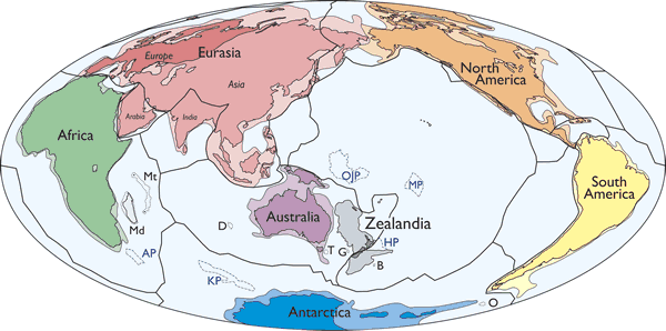
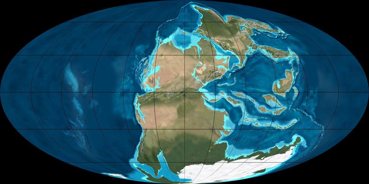
This simplified map of the continents shows the new continent Zealandia in grey. Image: Mortimer et. al. 2017, GSA Today.
We tend to lump New Zealand and Australia together. They’re similar culturally and share the same geographical position, relative to North America and Europe, anyway. But according to a new paper published in the Geological Society of America Today, it looks like New Zealand and their neighbor New Caledonia are actually their own continent: ‘Zealandia.’
Continent means something different to geographers and geologists. To be considered a geological continent, like Zealandia, the area in question has to satisfy a few conditions:
the land in question has to be higher than the ocean floor
it has to include a broad range of siliceous igneous, metamorphic, and sedimentary rocks
it has to have thicker crust than the ocean floor that surrounds it
it has to have well-defined limits, and be large enough to be considered a continent
In Geology, the first three points are well-understood. But as the authors say in the introduction to their paper, “…the last point—how “major” a piece of continental crust has to be to be called a continent—is almost never discussed… .” Since the Earth has so many micro-continents and continental fragments, defining how large something has to be to be called a continent is challenging. But the researchers did their homework.
They noted that the term “Zealandia” has been used before to describe New Zealand and surrounding regions. But the boundaries were never fully explored. 94% of this new continent is submerged, which helps explain why it’s taken this long to be identified.
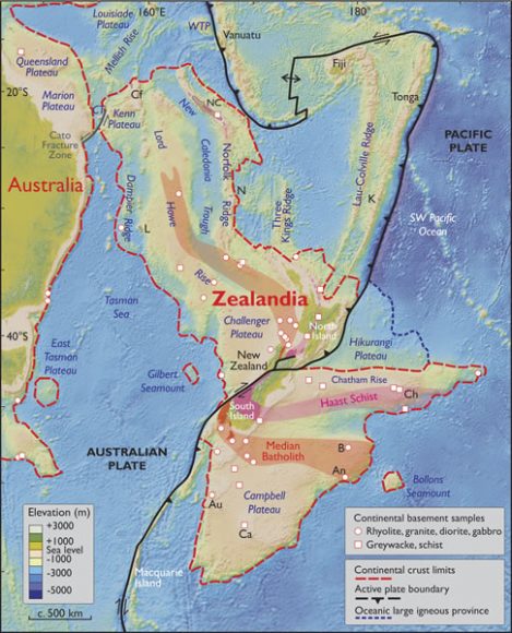
This map shows the spatial limits of Zealandia. Note the dotted red line that delineates continental crust from ocean crust. Zealandia is also bisected by a plate boundary between the Pacific Plate and the Australian Plate. Image: Mortimer et. al. 2017, GSA Today
Zealandia seemed to be a collection of broken pieces, but new data collected over the years has challenged that interpretation. Recent satellite data has given us new gravity and elevation maps of the seafloor. This data has shown that Zealandia is a unified region large as large as India.
“This is not a sudden discovery but a gradual realization; as recently as 10 years ago we would not have had the accumulated data or confidence in interpretation to write this paper.”
As the authors point out in their paper, it took a while to determine that Zealandia is a continent. There was no Eureka moment. “This is not a sudden discovery but a gradual realization; as recently as 10 years ago we would not have had the accumulated data or confidence in interpretation to write this paper.”
Besides satisfying our intellectual curiosity about our planet, the discovery is important for other reasons. A proper understanding of the plate structures and continental boundaries is important to other sciences, and may trigger further understandings that we can’t predict yet. It may also point to other areas of research.
Also, many treaties rely on the agreed upon delineation of maritime and continental boundaries, including rights to fish stocks and underground resources. While the recognition of Zealandia seems clear from a scientific standpoint, it remains to be seen if it will be accepted politically.
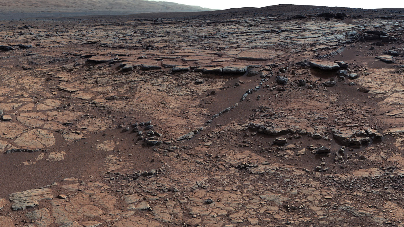
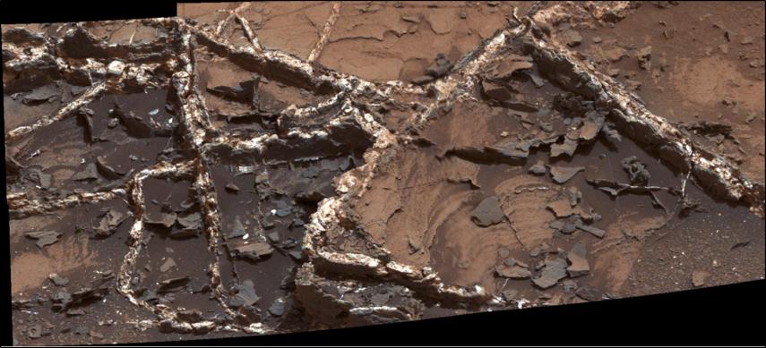
Bedrock at this site added to a puzzle about ancient Mars by indicating that a lake was present, but that little carbon dioxide was in the air to help keep a lake unfrozen. Credit: NASA/JPL-Caltech/MSSS
The study of Mars’ surface and atmosphere has unlocked some ancient secrets. Thanks to the efforts of the Curiosity rover and other missions, scientists are now aware of the fact that water once flowed on Mars and that the planet had a denser atmosphere. They have also been able to deduce what mechanics led to this atmosphere being depleted, which turned it into the cold, desiccated environment we see there today.
At the same time though, it has led to a rather intriguing paradox. Essentially, Mars is believed to have had warm, flowing water on its surface at a time when the Sun was one-third as warm as it is today. This would require that the Martian atmosphere had ample carbon dioxide in order to keep its surface warm enough. But based on the Curiosity rover’s latest findings, this doesn’t appear to be the case.
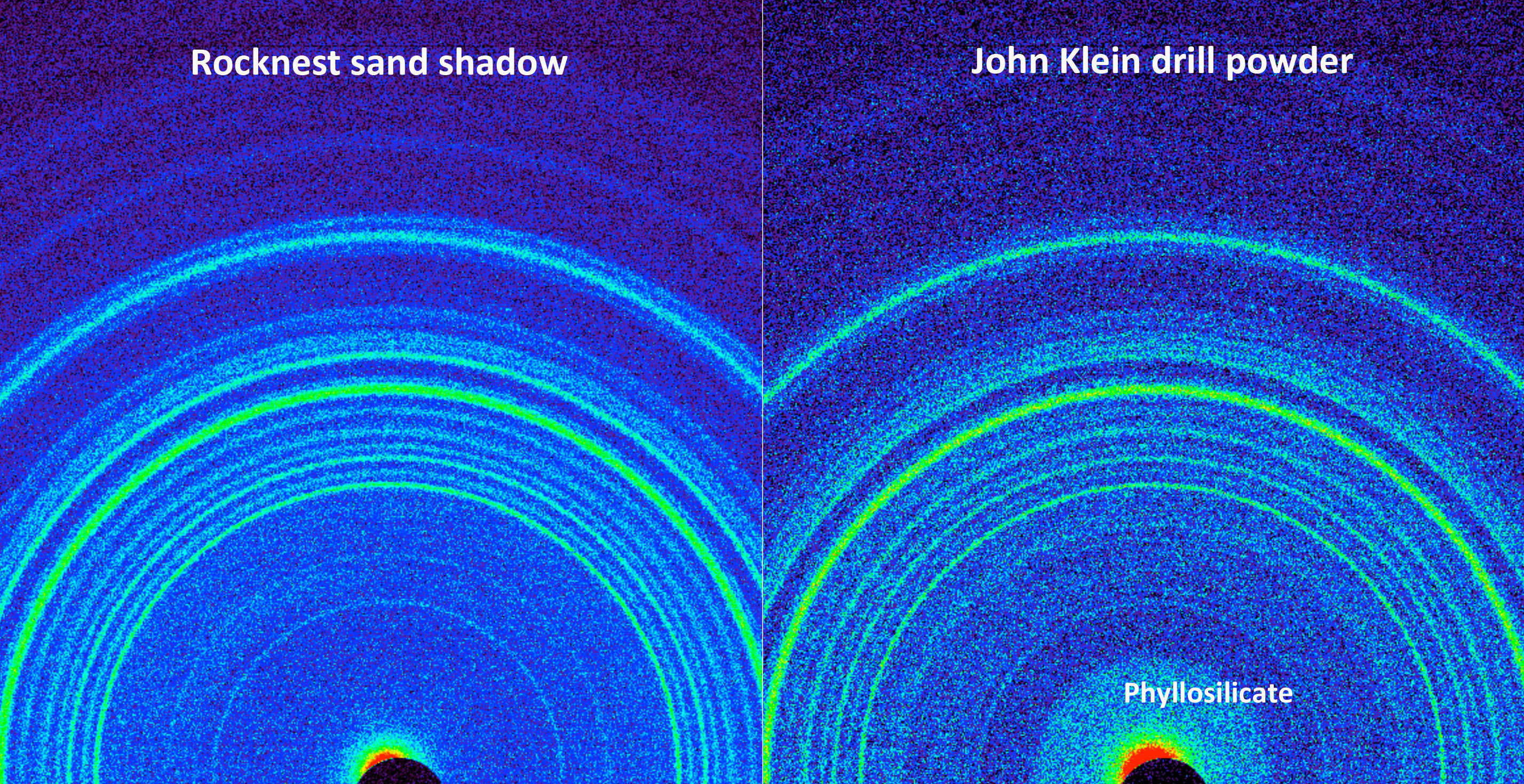
These findings were part of an analysis of data taken by the Curiosity’s Chemistry and Mineralogy X-ray Diffraction (CheMin) instrument, which has been used to study the mineral content of drill samples in the Gale Crater. The results of this analysis were recently published in Proceedings of the National Academy of Science, where the research team indicated that no traces of carbonates were found in any samples taken from the ancient lake bed.
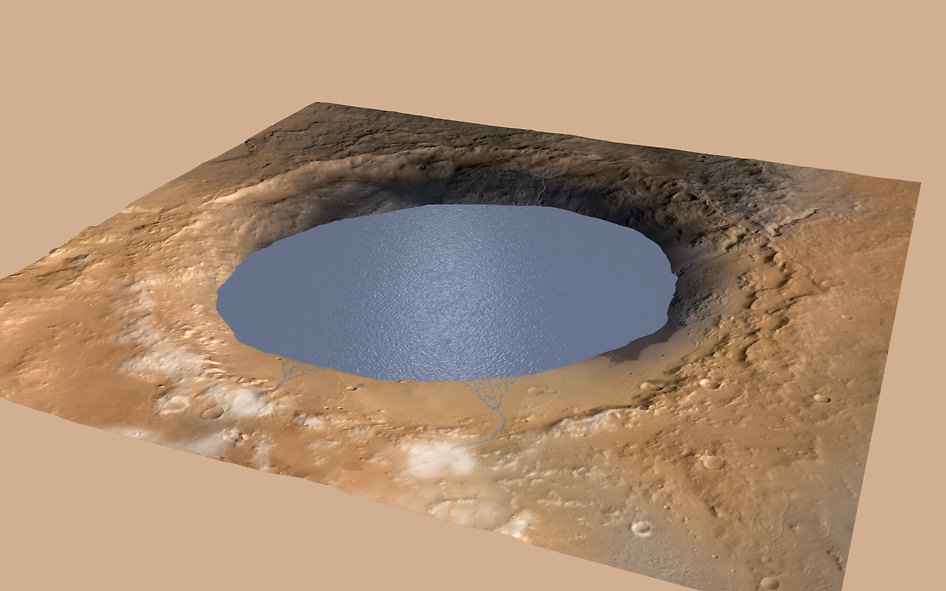
Simulated view of Gale Crater Lake on Mars, depicting a lake of water partially filling Mars’ Gale Crater. Credit: NASA/JPL-Caltech/ESA/DLR/FU Berlin/MSSS
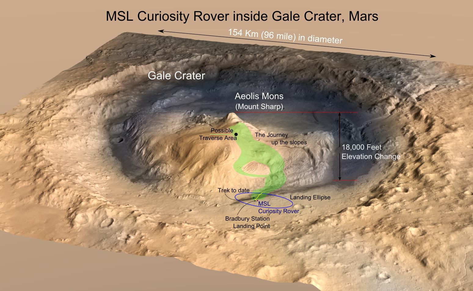
To break it down, evidence collected by Curiosity (and a slew of other rovers, landers and orbiters) has led scientists to conclude that roughly 3.5 billion years ago, Mars surface had lakes and flowing rivers. They have also determined, thanks to the many samples taken by Curiosity since it landed in the Gale Crater in 2011, that this geological feature was once a lake bed that gradually became filled with sedimentary deposits.
However, for Mars to have been warm enough for liquid water to exist, its atmosphere would have had to contain a certain amount of carbon dioxide – providing a sufficient Greenhouse Effect to compensate for the Sun’s diminished warmth. Since rock samples in the Gale Crater act as a geological record for what conditions were like billions of years ago, they would surely contain plenty of carbonate minerals if this were the case.
Carbonates are minerals that result from carbon dioxide combining with positively charged ions (like magnesium and iron) in water. Since these ions have been found to be in good supply in samples of Martian rock, and subsequent analysis has shown that conditions never became acidic to the point that the carbonates would have dissolved, there is no apparent reason why they wouldn’t be showing up.
Along with his team, Thomas Bristow – the principal investigator for the CheMin instrument on Curiosity – calculated what the minimum amount of atmospheric carbon dioxide would need to be, and how this would have been indicated by the levels of carbonate found in Martian rocks today. They then sorted through the years worth of the CheMin instrument’s data to see if there were any indications of these minerals.
Comparison of X-ray diffraction patterns of two different samples analyzed by Curiosity’s Chemistry and Mineralogy (CheMin) instrument. Credit: NASA/JPL-Caltech/Ames
But as he explained in a recent NASA press release, the findings simply didn’t measure up:
“We’ve been particularly struck with the absence of carbonate minerals in sedimentary rock the rover has examined. It would be really hard to get liquid water even if there were a hundred times more carbon dioxide in the atmosphere than what the mineral evidence in the rock tells us.”
In the end, Bristow and his team could not find even trace amounts of carbonates in the rock samples they analyzed. Even if just a few tens of millibars of carbon dioxide had been present in the atmosphere when a lake existed in the Gale Crater, it would have produced enough carbonates for Curiosity’s CheMin to detect. This latest find adds to a paradox that has been plaguing Mars researchers for years.
Basically, researchers have noted that there is a serious discrepancy between what surface features indicate about Mars’ past, and what chemical and geological evidence has to say. Not only is there plenty of evidence that the planet had a denser atmosphere in the past, more than four decades of orbital imaging (and years worth of surface data) have yielded ample geomorphological evidence that Mars once had surface water and an active hydrological cycle.
The Gale Crater – the landing location and trek of the Rover Curiosity – as it is today, imaged by the MRO. Credits: NASA/JPL, illustration, T.Reyes
However, scientists are still struggling to produce models that show how the Martian climate could have maintained the types of conditions necessary for this to have been the case. The only successful model so far has been one in which the atmosphere contained a significant amount of CO2 and hydrogen. Unfortunately, an explanation for how this atmosphere could be created and sustained remains elusive.
In addition, the geological and chemical evidence for such a atmosphere existing billions of years ago has also been in short supply. In the past, surveys by orbiters were unable to find evidence of carbonate minerals on the surface of Mars. It was hoped that surface missions, like Curiosity, would be able to resolve this by taking soil and drill samples where water had been known to exist.
But as Bristow explained, his team’s study has effectively closed the door on this:
“It’s been a mystery why there hasn’t been much carbonate seen from orbit. You could get out of the quandary by saying the carbonates may still be there, but we just can’t see them from orbit because they’re covered by dust, or buried, or we’re not looking in the right place. The Curiosity results bring the paradox to a focus. This is the first time we’ve checked for carbonates on the ground in a rock we know formed from sediments deposited under water.”
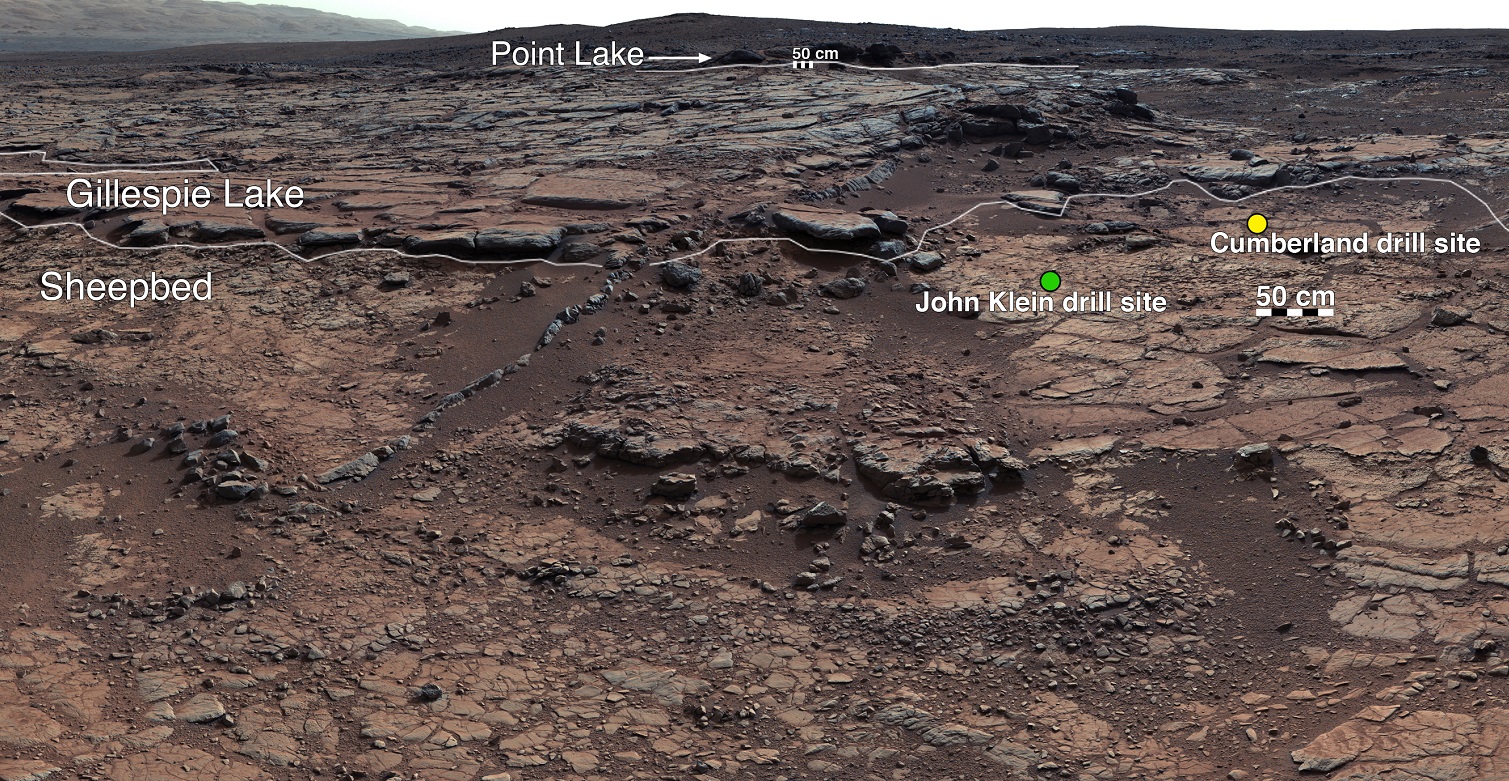
Annontated version of the bedrock site in the Gale Crater where the Curiosity rover has taken drill samples. Credit: NASA/JPL-Caltech/MSSS
There are several possible explanations for this paradox. On the one hand, some scientists have argued that the Gale Crater Lake may not have been an open body of water and was perhaps covered in ice, which was just thin enough to still allow for sediments to get in. The problem with this explanation is that if this were true, there would be discernible indications left behind – which would include deep cracks in the soft sedimentary lakebed rock.
But since these indications have not been found, scientists are left with two lines of evidence that do not match up. As Ashwin Vasavada, Curiosity’s Project Scientist, put it:
“Curiosity’s traverse through streambeds, deltas, and hundreds of vertical feet of mud deposited in ancient lakes calls out for a vigorous hydrological system supplying the water and sediment to create the rocks we’re finding. Carbon dioxide, mixed with other gases like hydrogen, has been the leading candidate for the warming influence needed for such a system. This surprising result would seem to take it out of the running.”
Luckily, incongruities in science are what allow for new and better theories to be developed. And as the exploration of the Martian surface continues – which will benefit from the arrival of the ExoMars and the Mars 2020missions in the coming years – we can expect additional evidence to emerge. Hopefully, it will help point the way towards a resolution for this paradox, and not complicate our theories even more!
Olympus Mons on Mars is the largest volano in our Solar System. Analysis of a Martian meteorite that fell to Earth in 2012 confirms that Mars also has the longest-lived volcanoes in our Solar System. Image: NASA/JPL
Mars is renowned for having the largest volcano in our Solar System, Olympus Mons. New research shows that Mars also has the most long-lived volcanoes. The study of a Martian meteorite confirms that volcanoes on Mars were active for 2 billion years or longer.
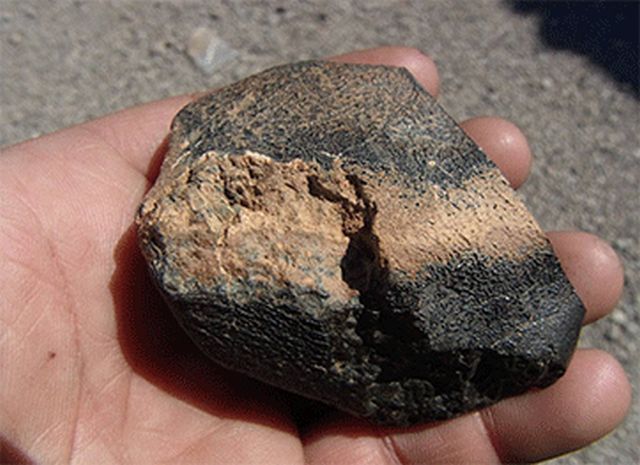
A lot of what we know about the volcanoes on Mars we’ve learned from Martian meteorites that have made it to Earth. The meteorite in this study was found in Algeria in 2012. Dubbed Northwest Africa 7635 (NWA 7635), this meteorite was actually seen travelling through Earth’s atmosphere in July 2011.
A sample from the meteorite Northwest Africa 7635. Image: Mohammed Hmani
The lead author of this study is Tom Lapen, a Geology Professor at the University of Houston. He says that his findings provide new insights into the evolution of the Red Planet and the history of volcanic activity there. NWA 7635 was compared with 11 other Martian meteorites, of a type called shergottites. Analysis of their chemical composition reveals the length of time they spent in space, how long they’ve been on Earth, their age, and their volcanic source. All 12 of them are from the same volcanic source.
Mars has much weaker gravity than Earth, so when something large enough slams into the Martian surface, pieces of rock are ejected into space. Some of these rocks eventually cross Earth’s path and are captured by gravity. Most burn up, but some make it to the surface of our planet. In the case of NWA 7635 and the other meteorites, they were ejected from Mars about 1 million years ago.
“We see that they came from a similar volcanic source,” Lapen said. “Given that they also have the same ejection time, we can conclude that these come from the same location on Mars.”
Taken together, the meteorites give us a snapshot of one location of the Martian surface. The other meteorites range from 327 million to 600 million years old. But NWA 7635 was formed 2.4 billion years ago. This means that its source was one of the longest lived volcanoes in our entire Solar System.
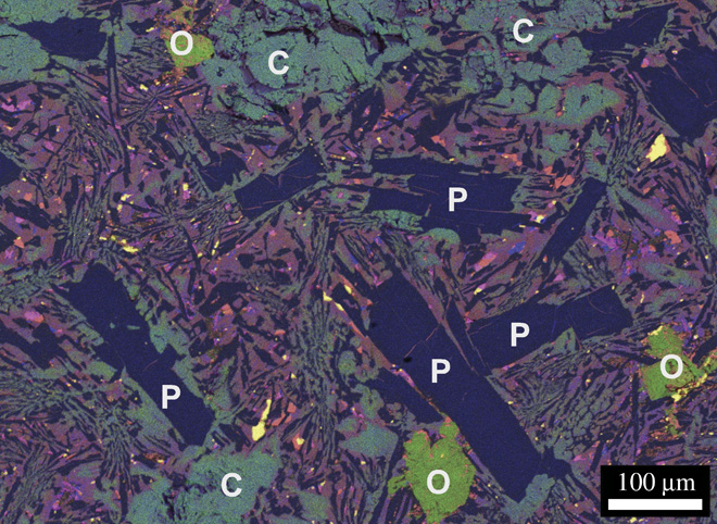
This false color X-ray of NWA 7635 shows the meteorite’s mineralogy mineral textures. O, olivine; P, plagioclase (maskelynite); C, clinopyroxene (augite). Chemical compositions: Fe (purple), Mg (green), Ca (blue), Ti (magenta), and S (yellow). Purple colors in the mesostasis represent Fe-rich augite. You’re welcome, mineral nerds. Image: Lapen et. al.
Volcanic activity on Mars is an important part of understanding the planet, and whether it ever harbored life. It’s possible that so-called super-volcanoes contributed to extinctions here on Earth. The same thing may have happened on Mars. Given the massive size of Olympus Mons, it could very well have been the Martian equivalent of a super-volcano.
The ESA’s Mars Express Orbiter sent back images of Olympus Mons that showed possible lava flows as recently as 2 million years ago. There are also lava flows on Mars that have a very small number of impact craters on them, indicating that they were formed recently. If that is the case, then it’s possible that Martian volcanoes will be visibly active again.
A colorized image of the surface of Mars taken by the Mars Reconnaissance Orbiter. The line of three volcanoes is the Tharsis Montes, with Olympus Mons to the northwest. Valles Marineris is to the east. Image: NASA/JPL-Caltech/ Arizona State University
Continuing volcanic activity on Mars is highly speculative, with different researchers arguing for and against it. The relatively crater-free, smooth surfaces of some lava features on Mars could be explained by erosion, or even glaciation. In any case, if there is another eruption on Mars, we would have to be extremely lucky for one of our orbiters to see it.
Using its HiRISE camera, the MRO has noted existence of tall networks of ridges on Mars that have diverse origins. Credit: NASA/JPL-Caltech/Univ. of Arizona
Mars has some impressive geological features across its cold, desiccated surface, many of which are similar to featured found here on Earth. By studying them, scientists are able to learn more about the natural history of the Red Planet, what kinds of meteorological phenomena are responsible for shaping it, and how similar our two planets are. A perfect of example of this are the polygon-ridge networks that have been observed on its surface.
One such network was recently discovered by the Mars Reconnaissance Orbiter (MRO) in the Medusae Fossae region, which straddles the planet’s equator. Measuring some 16 story’s high, this ridge network is similar to others that have been spotted on Mars. But according to a survey produced by researchers from NASA’s Jet Propulsion Laboratory, these ridges likely have different origins.
This survey, which was recently published in the journal Icarus, examined both the network found in the Medusae Fossae region and similar-looking networks in other regions of the Red Planet. These ridges (sometimes called boxwork rides), are essentially blade-like walls that look like multiple adjoining polygons (i.e. rectangles, pentagons, triangles, and similar shapes).
Shiprock, a ridge-feature in northwestern New Mexico that is 10 meters (30 feet) tall, which formed from lava filling an underground fracture that resisted erosion better than the material around it did. Credit: NASA
While similar-looking ridges can be found in many places on Mars, they do not appear to be formed by any single process. As Laura Kerber, of NASA’s Jet Propulsion Laboratory and the lead author of the survey report, explained in a NASA press release:
“Finding these ridges in the Medusae Fossae region set me on a quest to find all the types of polygonal ridges on Mars… Polygonal ridges can be formed in several different ways, and some of them are really key to understanding the history of early Mars. Many of these ridges are mineral veins, and mineral veins tell us that water was circulating underground.”
Such ridges have also been found on Earth, and appear to be the result of various processes as well. One of the most common involves lava flowing into preexisting fractures in the ground, which then survived when erosion stripped the surrounding material away. A good example of this is the Shiprock (shown above), a monadrock located in San Juan County, New Mexico.
Examples of polygon ridges on Mars include the feature known as “Garden City“, which was discovered by the Curiosity rover mission. Measuring just a few centimeters in height, these ridges appeared to be the result of mineral-laden groundwater moving through underground fissures, which led to standing mineral veins once the surrounding soil eroded away.
Mineral veins at the “Garden City” site, examined by NASA’s Curiosity Mars rover. Credit: NASA/JPL
At the other end of the scale, ridges that measure around 2 kilometers (over a mile) high have also been found. A good example of this is “Inca City“, a feature observed by the Mars Global Surveyor near Mars’ south pole. In this case, the feature is believed to be the result of underground faults (which were formed from impacts) filling with lava over time. Here too, erosion gradually stripped away the surrounding rock, exposing the standing lava rock.
In short, these features are evidence of underground water and volcanic activity on Mars. And by finding more examples of these polygon-ridges, scientists will be able to study the geological record of Mars more closely. Hence why Kerber is seeking help from the public through a citizen-science project called Planet Four: Ridges.
Established earlier this month on Zooniverse – a volunteer-powered research platform – this project has made images obtained by the MRO’s Context Camera (CTX) available to the public. Currently, this and other projects using data from CTX and HiRISE have drawn the participation of more than 150,000 volunteers from around the world.
By getting volunteers to sort through the CTX images for ridge formations, Kerber and her team hopes that previously-unidentified ones will be identified and that their relationship with other Martian features will be better understood.
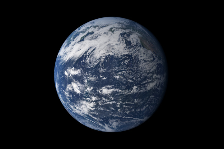
Earth, seen from space, above the Pacific Ocean. Credit: NASA
One look at planet Earth on a map, or based on an image taken from space, ought to convey just how immense and important our oceans are. After all, they cover 72% of the planet’s surface, occupy a total volume of around 1.35 billion cubic kilometers (320 million cu mi), and are essential to life as we know it. And in their great depths, many mysteries still wait to be discovered.
Thanks to modern science and improvement exploration vehicles, one of the most obvious has been tackled – which is the mystery of where the deepest ocean in the world lies. This is none other than the Pacific Ocean, which averages approximately 4,280 meters (14,042 ft) in depth and contains the deepest known part of any ocean – the Mariana Trench.
Methodology:
Of course, determining the depth of an ocean is tricky business, and for obvious reasons. Ocean floors are extremely extensive, and vary widely in terms of elevation. Much like continental land masses, they have mountain ranges and trenches that throw off the curve. And in some cases, the trenches are much deeper than the average depth.
The view of the Pacific Ocean from the ISS. Credit: NASA
However, in terms of average depth, the Pacific Ocean is the deepest. Though calculations vary, it is estimated that the entire ocean floor averages about 4,280 meters (14,042 ft), which is over 500 m (1640 ft) deeper than the global average of 3,700 meters (12,100 ft). Part of the reason for this is due to the Marian Trench, which is significantly deeper!
Characteristics:
The Marian Trench is located in the western Pacific Ocean near the Mariana Islands, almost equally distant from both the Philippines and Japan. The trench is crescent shaped, and measures roughly 2,550 kilometers (1,580 mi) long with an average width of 69 kilometers (43 mi).
It reaches a maximum-known depth of 10,994 meters (36,070 ft) – with a margin of error of 40 metes (130 ft) – at a small slot-shaped valley in its floor known as the Challenger Deep, located at its southern end. Countries near the trench include Japan, Papua New Guinea, Indonesia and the Philippines.
The geological feature is the result of subduction that occurs at the boundary between two tectonic plates – the Filipino and the Pacific Plate. This results in what is known as the Izu-Bonin-Mariana subduction system, where the western edge of the Pacific Plate is subducted (pushed under) the smaller Mariana plate (part of the Filipino Plate).
Location of the Mariana Trench. Credit: Wikipedia Commons/Kmusser
The movement of the Pacific and Mariana Plates also led to the formation of the Mariana Islands, which are volcanic in nature. They formed as a result of flux melting – i.e. where water cools hot lava – due to the release of water that was trapped in the subducted portion of the Pacific Plate.
To put just how deep the Mariana Trench is into perspective, let’s consider comparing it to Mount Everest. If you placed Mt. Everest inside the Mariana Trench, there would still be over 2,000 meters (6562 ft) of water covering the mountain.
The water pressure in the Mariana Trench is also 15,750 psi, which is more than 1000 times greater than the standard atmospheric pressure at sea level. This means that if you could stand at the bottom of the Mariana Trench, the pressure could literally crush you!
Measurement:
Numerous measurements of the trench have been taken over the years using different methods. The first mission was the Challenger expedition, which took place between 1872 and 1876. Using the sounding technique, they measured the deepest point of Mariana Trench to 9,636 meters (31,614 ft).
The HMS Challenger, which conducted the Challenger II measurements of the Mariana Trench. Credit: Imperial War Museums.
This was followed by the HMS Challenger, which conducted the Challenger II survey in 1931. Here, surveyors relied on the more accurate technique of echo-sounding, and retrieved a deepest measurement of 10,900 meters (35,760 ft). This area came to be known as the Challenger Deep.
During the latter half of the 20th century, multiple missions would be conducted. In 1957, the Soviet vessel Vityaz obtained depth readings of 11,034 meters (36,201 ft) at a location named “the Mariana Hollow”. This was followed in 1962 by the US merchant vessel Spencer F. Baird, which recorded a maximum depth of 10,915 meters (35,810 ft) using precision depth gauges.
In 1984, the Japanese survey vessel Takuyo used a narrow, multi-beam echo sounder and reported a maximum depth of 10,924 meters (35,840 ft). In 1995, another Japanese vessel – the remotely operated vehicle KAIKO – reached the deepest area of the Mariana trench, thus establishing the deepest diving record of 10,911 meters (35,797 ft).
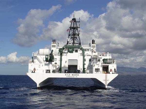
In 2009, the US research vessel Kilo Moana conducted the most accurate measurements of the Mariana Trench to date. This involved using sonar to map the Challenger Deep, which located a spot with a maximum depth of 10,971 meters (35,994 ft).
Rear view of the research vessel Kilo Moana. NOAA
Exploration:
Four missions have been made into the Mariana Trench. The first was the Trieste, a Swiss-designed, Italian-built, and US Navy-owned self-propelled submersible craft. On January 23rd, 1960, the craft and its two-man crew reached the bottom of the Trench, having reached a depth of 10,916 m (35,814 ft). This was followed by the unmanned Kaiko craft in 1996 and the autonomous craft Nereus in 2009.
The first three expeditions directly measured very similar depths of 10,902 to 10,916 m (35,768 to 35,814 ft). The fourth mission took place in 2012, where Canadian film director James Cameron mounted a mission using the submersible Deepsea Challenger. On March 26th, he reached the bottom of the Mariana Trench.
Several more missions have been planned as of February of 2012. These include Triton Submarines, a Florida-based company that designs and manufactures private submarines; and DOER Marine, a marine technology company based near San Francisco that plans to send a two or three-person sub to the seabed.
Beyond the coastlines, the world’s oceans are deep and unfathomable. Much of it remains unexplored and the life that scientists have found there is quite exotic (and may even provide insight into life on other worlds). Somehow, it seems appropriate that life in “inner space” would help us to understand life in “outer space”.
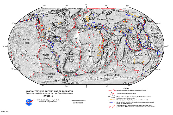
The "Global Tectonic and Volcanic Activity of the Last One Million Years" map. Credit: NASA/DTAM
For people who live on or near an active fault line – such as the San Andreas Fault in California, the Median Tectonic Line in Japan, or the Sunda Megathrust of southeast Asia – earthquakes are a regular part of life. Oftentimes, they can take the form of minor tremors that come and go without causing much damage.
But at other times, they are cataclysmic, causing widespread destruction and death tolls in the thousands or more. But what exactly is an earthquake? What geological forces lead to this destructive force? Where do they typically happen, and how many different types are there? And most importantly, how can we be better prepared for them?
Definition:
An earthquake is defined as a perceptible tremor in the surface of the Earth, which is caused by seismic waves resulting from the sudden release of energy in the Earth’s crust. Sometimes, they are detected because of the transfer of this energy to structures, causing noticeable shaking and noise. At other times, they can be violent enough to throw people and level entire cities.
Global earthquake epicenters, 1963–1998. Credit: NASA/DTAM
Generally, the term is used to describe any seismic event that generates seismic waves. An earthquake’s point of initial rupture is called its focus or hypocenter, while the point on the Earth directly above it (i.e. the most immediately-effected area) is called the epicenter.
Causes:
The structure of the Earth’s crust, which is divided into several “tectonic plates”, is responsible for most earthquakes. These plates are constantly in motion due to convection in the Earth’s semi-viscous upper mantle. Over time, these plates will separate and crash into each other, creating visible boundaries called faults.
When plates collide, they remain locked until enough pressure builds that one of them is forced under the other (a process known as subduction). This process occurs over the course of millions of years, and occasionally results in a serious release of energy, frictional heating and cracking along the fault lines (aka. an earthquake).
The energy waves that result are divided into two categories – surface waves and body waves. Surface waves are so-named because they are the energy that reaches the surface of the Earth, while body waves refer to the energy that remains within the planet’s interior.
Map of the Earth’s Tectonic Plates. Credit: msnucleus.org
It is estimated that only 10% or less of an earthquake’s total energy is radiated as seismic energy, while the rest is used to power the fracture growth or is converted into friction heat. However, what reaches the surface triggers all of the effects that we humans associate with earthquakes – i.e. tremors that vary in duration and intensity.
Occasionally, earthquakes can happen away from fault lines. These are due to some plate boundaries being located in regions of continental lithosphere, where deformation is spread out over a much larger area than the plate boundary. Under these conditions, earthquakes are related to strains developed within the broader zone of deformation.
Earthquakes within a plate (called “intraplate earthquakes”) can also happen as a result of internal stress fields, which are caused by interaction with neighboring plates, as well as sedimentary loading or unloading.
Aside from naturally occurring earthquakes (aka. tectonic earthquakes) that occur along tectonic plate lines (fault lines), there are also those that fall under the heading of “human-made earthquakes”. These are all the result of human activity, which is most often the result of nuclear testing.
Earthquakes can also be caused by human-made factors, such as nuclear testing. Credit: NNSA
This type of earthquake can been felt all from considerable distance after the detonation of a nuclear weapon. There is very little actual data that is readily available on this type of earthquake, but, compared to tectonic activity, it can be easily predicted and controlled.
Measurements:
Scientists measure earthquakes using seismometers, which measures sound waves through the Earth’s crust. There is also a method of measuring the intensity of an earthquake. It is known as the Richter Scale, which grades earthquakes from 1 to 10 based on their intensity.
Although there is no upper limit to the scale, most people set ten as the upper limit because no earthquakes equal to or greater than ten have been recorded. Scientist hypothesize that level 10 earthquakes were probably more common in prehistoric times, especially as the result of meteor impacts.
Effects of Earthquakes:
Earthquakes can happen on land or at sea, and can therefore trigger other natural disasters. In the case of those that take place on land, displacement of the ground is often the result, which can cause landslides or even volcanoes. When they take place at sea, the displacement of the seabed often results, causing a tsunami.
Map of earthquakes around the world in a seven day period. Credit: USGS / Google Maps / AJAX / SODA
Even though major earthquakes do not happen that often, they can cause substantial damage. In addition to the aforementioned natural disasters they can cause, earthquakes can also trigger fires when gas or electrical lines are damaged and floods when dams are destroyed.
Some of the most devastating earthquakes in history include the 1556 Shaanxi earthquake, which occurred on January 1556 in China. This quake resulted in widespread destruction of housing in the region – most of the housing being dwellings carved directly out of the silt stone mountain – and led to over 830,000 deaths.
The 1976 Tangshan earthquake, which took place in north-eastern China, was the deadliest of the 20th century, leading to he deaths of between 240,000 and 655,000 people. The 1960 Chilean earthquake is the largest earthquake that has been measured on a seismograph, reaching 9.5 magnitude on May 22nd, 1960.
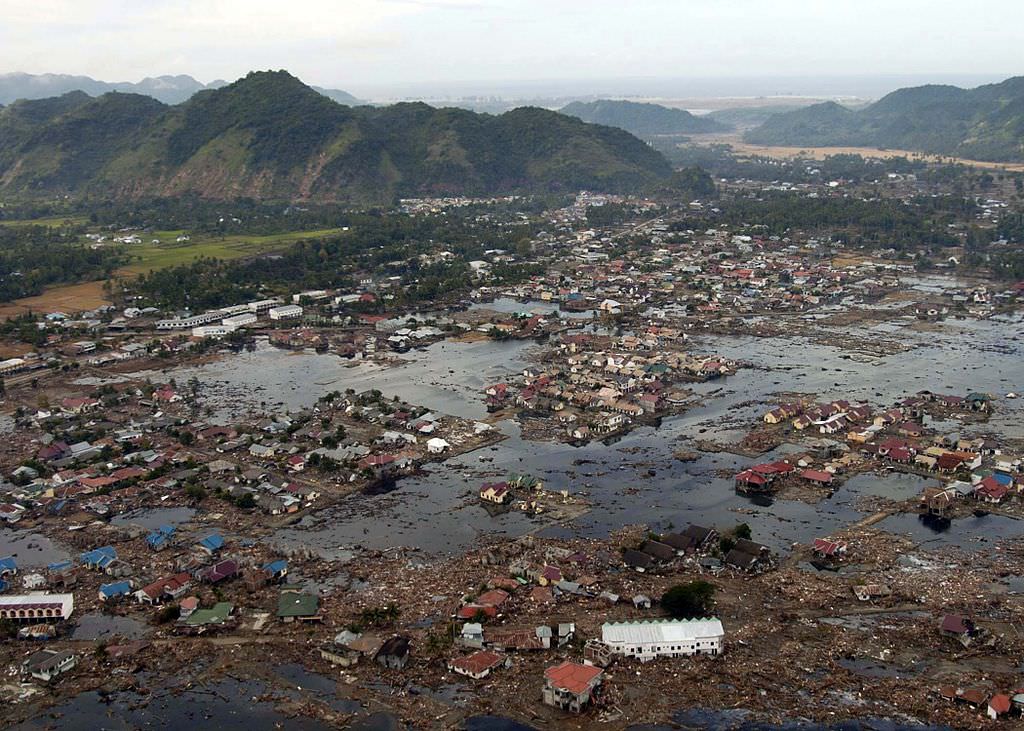
And then there was the 2004 Indian Ocean earthquake, a seismic event that also triggered a massive tsunami that caused devastation throughout southeast Asia. This quake reached 9.1 – 9.3 on the Richter Scale, struck coastal communities with waves measuring up to 30 meters (100 ft) high, and caused the deaths of 230,000 people in 14 countries.
A village near the coast of Sumatra that was devastated by the 2004 Tsunami. Credit: Wikipedia Commons/US Navy
Warning Systems:
More than 3 million earthquakes occur each year, which works out to about 8,000 earthquakes each day. Most of these occur in specific regions, mainly because they usually happen along the borders of tectonic plates. Despite being difficult to predict (except where human agency is the cause) some early warning methods have been devised.
For instance, using seismological data obtained in well-understood fault regions, earthquakes can be reasonably predicted weeks or months in advance. Regional notifications are also used whenever earthquakes are in progress, but before the shocks have struck, allowing people time to seek shelter in time.
Much like volcanoes, tornadoes, and debris flows, earthquakes are a force of nature that is not to be taken lightly. While they are a regular feature of our planet’s geological activity, they have had a considerable impact on human societies. And just like the eruption that buried Pompeii or the Great Flood, they are remembered long after they strike!
Landslides constitute one of the most destructive geological hazards in the world today. One of the main reasons for this is because of the high speeds that slides can reach, up to 160 km/hour (100 mph). Another is the fact that these slides can carry quite a bit of debris with them that serve to amplify their destructive force.
Taken together, this is what is known as a Debris Flow, a natural hazard that can take place in many parts of the world. A single flow is capable of burying entire towns and communities, covering roads, causing death and injury, destroying property and bringing all transportation to a halt. So how do we deal with them?
Definition:
A Debris Flow is basically a fast-moving landslide made up of liquefied, unconsolidated, and saturated mass that resembles flowing concrete. In this respect, they are not dissimilar from avalanches, where unconsolidated ice and snow cascades down the surface of a mountain, carrying trees and rocks with it.
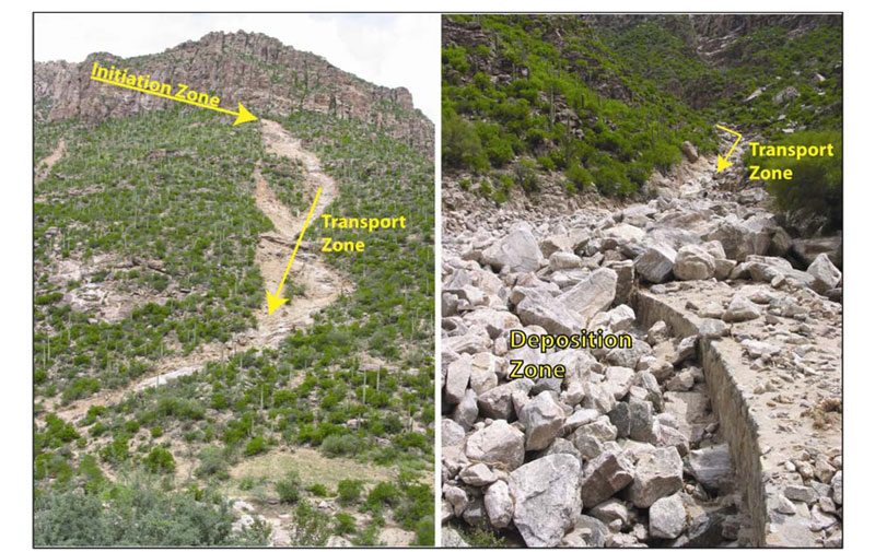
Images of a Debris Flow Chute and Deposit, taken by the Arizona Geological Survey (AZGS). Credit: azgs.com
A common misconception is to confuse debris flows with landslides or mudflows. In truth, they differ in that landslides are made up of a coherent block of material that slides over surfaces. Debris flows, by contrast, are made up of “loose” particles that move independently within the flow.
Similarly, mud flows are composed of mud and water, whereas debris flows are made up larger particles. All told, it has been estimated that at least 50% of the particles contained within a debris flow are made-up of sand-sized or larger particles (i.e. rocks, trees, etc).
Types of Flows:
There are two types of debris flows, known as Lahar and Jökulhlaup. The word Lahar is Indonesian in origin and has to do with flows that are related to volcanic activity. A variety of factors may trigger a lahar, including melting of glacial ice due to volcanic activity, intense rainfall on loose pyroclastic material, or the outbursting of a lake that was previously dammed by pyroclastic or glacial material.
Jökulhlaup is an Icelandic word which describes flows that originated from a glacial outburst flood. In Iceland, many such floods are triggered by sub-glacial volcanic eruptions, since Iceland sits atop the Mid-Atlantic Ridge. Elsewhere, a more common cause of jökulhlaups is the breaching of ice-dammed or moraine-dammed lakes.
Debris flow channel in Ladakh, near the northwestern Indian Himalaya, produced in the storms of August 2010. Credit: Wikipedia Commons/DanHobley
Such breaching events are often caused by the sudden calving of glacier ice into a lake, which then causes a displacement wave to breach a moraine or ice dam. Downvalley of the breach point, a jökulhlaup may increase greatly in size by picking up sediment and water from the valley through which it travels.
Causes of Flows:
Debris flows can be triggered in a number of ways. Typically, they result from sudden rainfall, where water begins to wash material from a slope, or when water removed material from a freshly burned stretch of land. A rapid snowmelt can also be a cause, where newly-melted snow water is channeled over a steep valley filled with debris that is loose enough to be mobilized.
In either case, the rapidly moving water cascades down the slopes and into the canyons and valleys below, picking up speed and debris as it descends the valley walls. In the valley itself, months’ worth of built-up soil and rocks can be picked up and then begin to move with the water.
As the system gradually picks up speed, a feedback loop ensues, where the faster the water flows, the more it can pick up. In time, this wall begins to resemble concrete in appearance but can move so rapidly that it can pluck boulders from the floors of the canyons and hurl them along the path of the flow. It’s the speed and enormity of these carried particulates that makes a debris flow so dangerous.
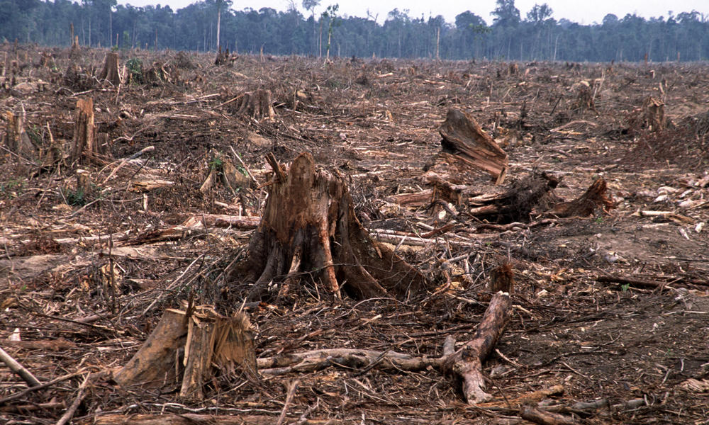
Deforestation (like this clearcut in Sumatra, Indonesia) can result in debris flows. Credit: worldwildlife.org
Another major cause of debris flows is the erosion of steams and riverbanks. As flowing water gradually causes the banks to collapse, the erosion can cut into thick deposits of saturated materials stacked up against the valley walls. This erosion removes support from the base of the slope and can trigger a sudden flow of debris.
In some cases, debris flows originate from older landslides. These can take the form of unstable masses perched atop a steep slope. After being lubricated by a flow of water over the top of the old landslide, the slide material or erosion at the base can remove support and trigger a flow.
Some debris flows occur as a result of wildfires or deforestation, where vegetation is burned or stripped from a steep slope. Prior to this, the vegetation’s roots anchored the soil and removed absorbed water. The loss of this support leads to the accumulation of moisture which can result in structural failure, followed by a flow.
Sarychev volcano, (located in Russia’s Kuril Islands, northeast of Japan) in an early stage of eruption on June 12, 2009. Credit: NASA
A volcanic eruption can flash melt large amounts of snow and ice on the flanks of a volcano. This sudden rush of water can pick up ash and pyroclastic debris as it flows down the steep volcano and carry them rapidly downstream for great distances.
In the 1877 eruption of Cotopaxi Volcano in Ecuador, debris flows traveled over 300 kilometers down a valley at an average speed of about 27 kilometers per hour. Debris flows are one of the deadly “surprise attacks” of volcanoes.
Prevention Methods:
Many methods have been employed for stopping or diverting debris flows in the past. A popular method is to construct debris basins, which are designed to “catch” a flow in a depressed and walled area. These are specifically intended to protect soil and water sources from contamination and prevent downstream damage.
Some basins are constructed with special overflow ducts and screens, which allow the water to trickle out from the flow while keeping the debris in place, while also allowing for more room for larger objects. However, such basins are expensive, and require considerable labor to build and maintain; hence why they are considered an option of last resort.
Aerial view of the destruction caused by a debris-flow in the Venezuelan town of Caraballeda. Credit: US Geological Survey
Currently, there is no way to monitor for the possibility of debris flow, since they can occur very rapidly and are often dependent on cycles in the weather that can be unpredictable. However, early warning systems are being developed for use in areas where debris flow risk is especially high.
One method involves early detection, where sensitive seismographs detect debris flows that have already started moving and alert local communities. Another way is to study weather patterns using radar imaging to make precipitation estimates – using rainfall intensity and duration values to establish a threshold of when and where a flows might occur.
In addition, replanting forests on hillsides to anchor the soil, as well as monitoring hilly areas that have recently suffered from wildfires is a good preventative measure. Identifying areas where debris flows have happened in the past, or where the proper conditions are present, is also a viable means of developing a debris flow mitigation plan.
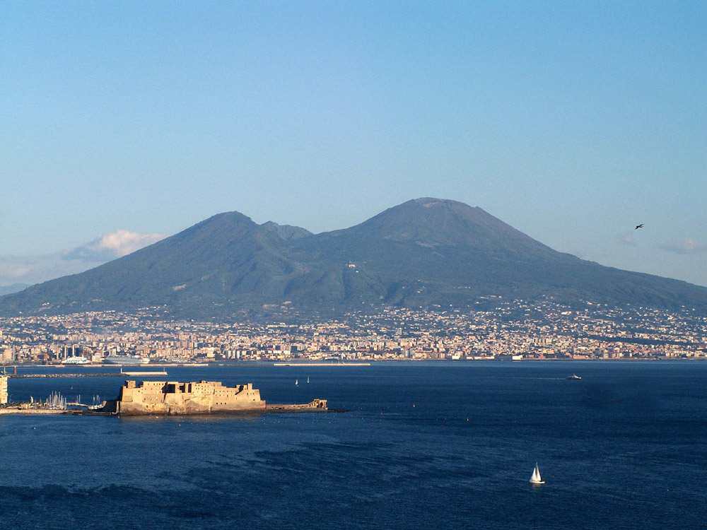
Volcanoes are an impressive force of nature. Physically, they dominate the landscape, and have an active role in shaping our planet’s geography. When they are actively erupting, they are an extremely dangerous and destructive force. But when they are passive, the soil they enrich can become very fertile, leading to settlements and cities being built nearby.
Such is the nature of volcanoes, and is the reason why we distinguish between those that are “active” and those that are “dormant”. But what exactly is the differences between the two, and how do geologists tell? This is actually a complicated question, because there’s no way to know for sure if a volcano is all done erupting, or if it’s going to become active again.
Put simply, the most popular way for classifying volcanoes comes down to the frequency of their eruption. Those that erupt regularly are called active, while those that have erupted in historical times but are now quiet are called dormant (or inactive). But in the end, knowing the difference all comes down to timing!
Sarychev volcano, (located in Russia’s Kuril Islands, northeast of Japan) in an early stage of eruption on June 12, 2009. Credit: NASA
Active Volcano:
Currently, there is no consensus among volcanologists about what constitutes “active”. Volcanoes – like all geological features – can have very long lifespans, varying between months to even millions of years. In the past few thousand years, many of Earth’s volcanoes have erupted many times over, but currently show no signs of impending eruption.
As such, the term “active” can mean only active in terms of human lifespans, which are entirely different from the lifespans of volcanoes. Hence why scientists often consider a volcano to be active only if it is showing signs of unrest (i.e. unusual earthquake activity or significant new gas emissions) that mean it is about to erupt.
Aleutian island #volcano letting off a little steam after the new year on Jan 2, 2016. #YearInSpace. Credit: NASA/Scott Kelly/@StationCDRKelly
By this definition, those volcanoes that have erupted in the course of human history (which includes more than 500 volcanoes) are defined as active. However, this too is problematic, since this varies from region to region – with some areas cataloging volcanoes for thousands of years, while others only have records for the past few centuries.
As such, an “active volcano” can be best described as one that’s currently in a state of regular eruptions. Maybe it’s going off right now, or had an event in the last few decades, or geologists expect it to erupt again very soon. In short, if its spewing fire or likely to again in the near future, then it’s active!
Dormant Volcano:
Meanwhile, a dormant volcano is used to refer to those that are capable of erupting, and will probably erupt again in the future, but hasn’t had an eruption for a very long time. Here too, definitions become complicated since it is difficult to distinguish between a volcano that is simply not active at present, and one that will remain inactive.
Volcanoes are often considered to be extinct if there are no written records of its activity. Nevertheless, volcanoes may remain dormant for a long period of time. For instance, the volcanoes of Yellowstone, Toba, and Vesuvius were all thought to be extinct before their historic and devastating eruptions.
The area around Mount Vesuvius, which erupted in 79 CE, is now densely populated. Credit: Wikipedia Commons/Jeffmatt
The same is true of the Fourpeaked Mountain eruption in Alaska in 2006. Prior to this, the volcano was thought to be extinct since it had not erupted for over 10,000 years. Compare that to Mount Grímsvötn in south-east Iceland, which erupted three times in the past 12 years (in 2011, 2008 and 2004, respectively).
And so a dormant volcano is actually part of the active volcano classification, it’s just that it’s not currently erupting.
Extinct Volcano:
Geologists also employ the category of extinct volcano to refer to volcanoes that have become cut off from their magma supply. There are many examples of extinct volcanoes around the world, many of which are found in the Hawaiian-Emperor Seamount Chain in the Pacific Ocean, or stand individually in some areas.
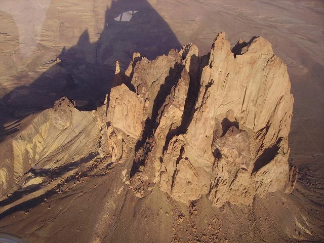
For example, the Shiprock volcano, which stands in Navajo Nation territory in New Mexico, is an example of a solitary extinct volcano. Edinburgh Castle, located just outside the capitol of Edinburgh, Scotland, is famously located atop an extinct volcano.
Aerial photograph of the Shiprock extinct volcano. Credit: Wikipedia Commons
But of course, determining if a volcano is truly extinct is often difficult, since some volcanoes can have eruptive lifespans that measure into the millions of years. As such, some volcanologists refer to extinct volcanoes as inactive, and some volcanoes once thought to be extinct are now referred to as dormant.
In short, knowing if a volcano is active, dormant, or extinct is complicated and all comes down to timing. And when it comes to geological features, timing is quite difficult for us mere mortals. Individuals and generations have limited life spans, nations rise and fall, and even entire civilization sometimes bite the dust.
But volcanic formations? They can endure for millions of years! Knowing if there still life in them requires hard work, good record-keeping, and (above all) immense patience.
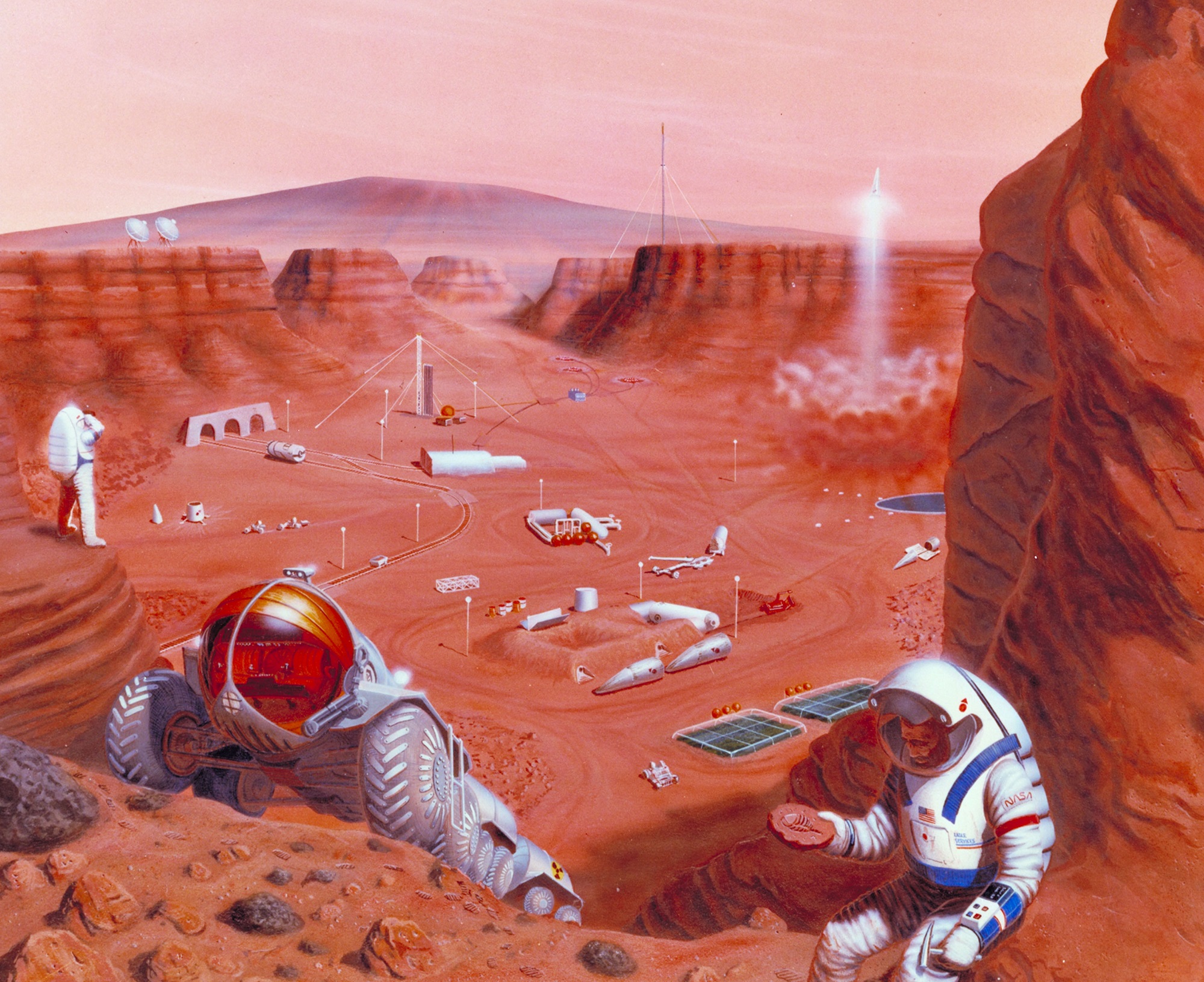
Future missions to Mars and other locations in the Solar System may depend heavily on the skills of planetary geologists. Credit: NASA Ames Research Center
In the coming decades, the world’s largest space agencies all have some rather big plans. Between NASA, the European Space Agency (ESA), Roscosmos, the Indian Space Research Organisation (ISRO), or the China National Space Administration (CNSA), there are plans to return to the Moon, crewed missions to Mars, and crewed missions to Near-Earth Objects (NEOs).
In all cases, geological studies are going to be a major aspect of the mission. For this reason, the ESA recently unveiled a new training program known as the Pangaea course, a study program which focuses on identifying planetary geological features. This program showcases just how important planetary geologists will be to future missions.
Pangaea takes its name from the super-continent that that existed during the late Paleozoic and early Mesozoic eras (300 to 175 million years ago). Due to convection in Earth’s mantle, this continent eventually broke up, giving rise to the seven continents that we are familiar with today.
The super-continent Pangea during the Permian period (300 – 250 million years ago). Credit: NAU Geology/Ron Blakey
Francesco Sauro – a field geologist, explorer and the designer of the course – explained the purpose of Pangaea in an ESA press release:
“This Pangaea course – named after the ancient supercontinent – will help astronauts to find interesting rock samples as well as to assess the most likely places to find traces of life on other planets. We created a course that enables astronauts on future missions to other planetary bodies to spot the best areas for exploration and the most scientifically interesting rocks to take samples for further analysis by the scientists back on Earth.”
This first part of the course will take place this week, where astronaut trainer Matthias Maurer and astronauts Luca Parmitano and Pedro Duque will be learning from a panel of planetary geology experts. These lessons will include how to recognize certain types of rock, how to draw landscapes, and the exploration of a canyon that has sedimentary features similar to the ones observed in the Murray Buttes region, which was recently imaged by the Curiosity rover.
The geology panel will include such luminaries as Matteo Messironi (a geologist working on the Rosetta and ExoMars missions), Harald Hiesinger (an expert in lunar geology), Anna Maria Fioretti (a meteorite expert), and Nicolas Mangold (a Mars expert currently working with NASA’s Curiosity team).
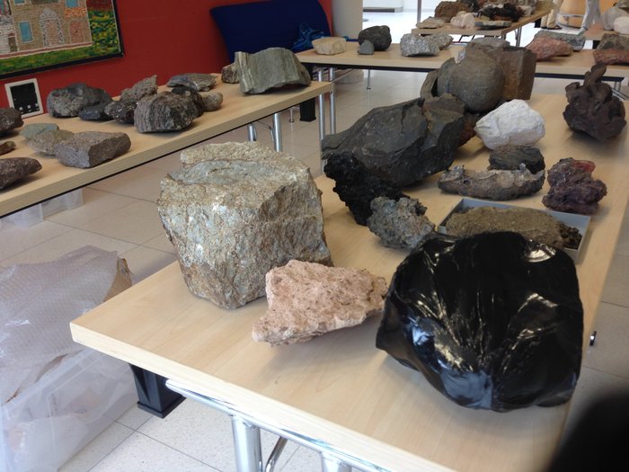
Rock samples on display at ESA’s Pangaea training course, which is intended to help astronauts in identify planetary geological features for future missions to the Moon, Mars and asteroids. Credit: ESA/L. Bessone
Once this phase of the course is complete, a series of field trips will follow to locations that were chosen because their geological features resemble those of other planets. This will include the town of Bressanone in northeastern Italy, which lies a few kilometers outside of the Brenner Pass (the part of the Alps that lies between Italy and Austria).
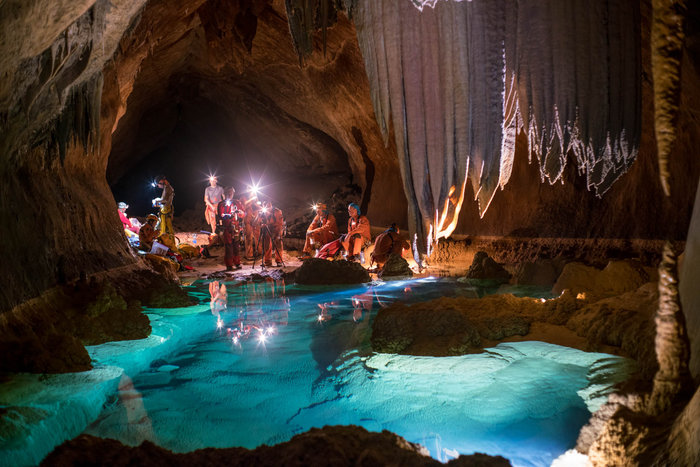
This past summer, the latest program involved a team of six international astronauts spending two weeks in a cave network in Sardinia, Italy. In this environment, 800-meters (2625 ft) beneath the surface, the team carried out a series of research and exploration activities designed to recreate aspects of a space expedition.
As the teams explore the caves of Sardinia, they encountered caverns, underground lakes and examples of strange microscopic life – all things they could encounter in extra-terrestrial environments. While doing this, they also get the change to test out new technologies and methods for research and experiments.
Sedimentary outcroppings in the Bressanoe region (left), compared to sedimentary deposits in the Murray Buttes region on Mars (right). Credit: ESA/I. Drozdovsky (left); NASA (right)
In a way that is similar to expeditions aboard the ISS, the program was designed to teach an international team of astronauts how to address the challenges of living and working in confined spaces. These include limited privacy, less equipment for hygiene and comfort, difficult conditions, variable temperatures and humidity, and extremely difficult emergency evacuation procedures.
Above all, the program attempts to foster teamwork, communication skills, decision-making, problem-solving, and leadership. This program is now an integral part of the ESA’s astronaut training and is conducted once a year. And as project leader Loredana Bessone explained, the Pangaea course fits with the aims of the CAVES program quite well.
“Pangaea complements our CAVES underground training,” she said. “CAVES focuses on team behaviour and operational aspects of a space mission, whereas Pangaea focuses on developing knowledge and skills for planetary geology and astrobiology.”
From all of these efforts, it is clear that the ESA, NASA and other space agencies want to make sure that future generations of astronauts are trained to conduct field geology and will be able to identify targets for scientific research. But of course, understanding the importance planetary geology in space exploration is not exactly a new phenomenon.
The six-member CAVES team in Sardinia, Italy, observing an underground pool. Credit: ESA/V. Crobu
In fact, the study of planetary geology is rooted in the Apollo era, when it became a field separate from other fields of geological research. And geology experts played a very pivotal role when it came to selecting the landing sites of the Apollo missions. As Emily Lakdawalla, the Senior Editor of The Planetary Society (and a geologist herself), told Universe Today in a phone interview:
“The Apollo astronauts received training in field geology before they went to the Moon. Jim Head at Brown University, who was my advisor, was one person who provided that training. Before there were missions, the Lunar Orbiter program returned photos that geologists used to map the surface of the Moon and find good landing sites.”
This tradition is being carried on today with instruments like the Mars Global Surveyor. Before the Spirit and Opportunity rovers were deployed to the Martian surface, NASA scientists studied images taken by this orbiter to determine which potential landing sites would prove to be the valuable for conducting research.
And thanks to the experience gained by the Apollo missions and improvements made in both technology and instrumentation, the process has become much more sophisticated. Compared to the Apollo-era, today’s NASA mission planners have much more detailed information to go on.
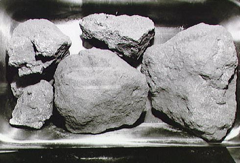
Moon rocks from the Apollo 11 mission. Credit: NASA
“These days, the orbiter photos have such high resolutions that its just like having aerial photographs, which is something Earth geologists have always used as a tool to scope out an area before going to study it,” Lakdawalla said. “With these photos, we can map out an area in detail before we send a rover, and determine where the most high-value samples will be.”
Looking ahead, everything that’s learned from sending astronauts to the Moon – and from the study of the lunar rocks they brought back – is going to play a vital role when it comes time to explore Mars, go back to the Moon, and investigate NEOs. As Lakdawalla explained, in each case, the purpose of the geological studies will be a bit different.
“The goal in obtaining samples from the Moon was about understanding the chronology of the Moon. The timescale we have developed for the Moon are anchored in the Apollo samples. But we think that the samples have been sampling one major impact – the Imbrium impact. The next Moon samples will attempt to sample other time periods so we can determine if our time scales are correct.”
“On Mars, the questions is, ‘what are the history of water on Mars’. You try to find rocks from orbit that will answer that questions – rocks that have either been altered by water or formed in water. And that is how you select your landing zone.”
And with future missions to NEOs, astronauts will be tasked with examining geological samples which date back to the formation of the Solar System. From this, we are likely to get a better understanding of how our Solar System formed and evolved over the many billion years it has existed.
Clearly, it is a good time to be a geologist, as their expertise will be called upon for future missions to space. Hope they like tang!
The 2006 Cleveland Volcano Eruption viewed from space. Credit: NASA
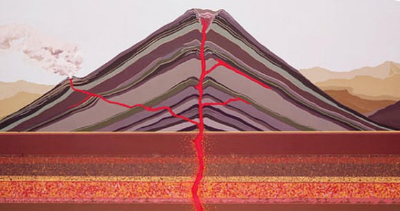
Volcanoes come in many shapes and sizes, ranging from common cinder cone volcanoes that build up from repeated eruptions and lava domes that pile up over volcanic vents to broad shield volcanoes and composite volcanoes. Though they differ in terms of structure and appearance, they all share two things. On the one hand, they are all awesome forces of nature that both terrify and inspire.
On the other, all volcanic activity comes down to the same basic principle. In essence, all eruptions are the result of magma from beneath the Earth being pushed up to the surface where it erupts as lava, ash and rock. But what mechanisms drive this process? What is it exactly that makes molten rock rise from the Earth’s interior and explode onto the landscape?
To understand how volcanoes erupt, one first needs to consider the structure of the Earth. At the very top is the lithosphere, the outermost layers of the Earth that consists of the upper mantle and crust. The crust makes up a tiny volume of the Earth, ranging from 10 km in thickness on the ocean floor to a maximum of 100 km in mountainous regions. It is cold and rigid, and composed primarily of silicate rock.
The Earth’s layers, showing the Inner and Outer Core, the Mantle, and Crust. Credit: discovermagazine.com
Beneath the crust, the Earth’s mantle is divided into sections of varying thickness based on their seismology. These consist of the upper mantle, which extends from a depth of 7 – 35 km (4.3 to 21.7 mi)) to 410 km (250 mi); the transition zone, which ranges from 410–660 km (250–410 mi); the lower mantle, which ranges from 660–2,891 km (410–1,796 mi); and the core–mantle boundary, which is ~200 km (120 mi) thick on average.
In the mantle region, conditions change drastically from the crust. Pressures increase considerably and temperatures can reach up to 1000 °C, which makes the rock viscous enough that it behaves like a liquid. In short, it experiences elastically on time scales of thousands of years or greater. This viscous, molten rock collects into vast chambers beneath the Earth’s crust.
Since this magma is less dense than the surrounding rock, it ” floats” up to the surface, seeking out cracks and weaknesses in the mantle. When it finally reaches the surface, it explodes from the summit of a volcano. When it’s beneath the surface, the molten rock is called magma. When it reaches the surface, it erupts as lava, ash and volcanic rocks.
The Earth’s Tectonic Plates. Credit: msnucleus.org
With each eruption, rocks, lava and ash build up around the volcanic vent. The nature of the eruption depends on the viscosity of the magma. When the lava flows easily, it can travel far and create wide shield volcanoes. When the lava is very thick, it creates a more familiar cone volcano shape (aka. a cinder cone volcano). When the lava is extremely thick, it can build up in the volcano and explode (lava domes).
Another mechanism that drives volcanism is the motion the crust undergoes. To break it down, the lithosphere is divided into several plates, which are constantly in motion atop the mantle. Sometimes the plates collide, pull apart, or slide alongside each other; resulting in convergent boundaries, divergent boundaries, and transform boundaries. This activity is what drives geological activity, which includes earthquakes and volcanoes.
In the case of the former, subduction zones are often the result, where the heavier plate slips under the lighter plate – forming a deep trench. This subduction changes the dense mantle into buoyant magma, which rises through the crust to the Earth’s surface. Over millions of years, this rising magma creates a series of active volcanoes known as a volcanic arc.
Cross-section of a volcano. Credit: 3dgeography.co.uk
In short, volcanoes are driven by pressure and heat in the mantle, as well as tectonic activity that leads to volcanic eruptions and geological renewal. The prevalence of volcanic eruptions in certain regions of the world – such as the Pacific Ring of Fire – also has a profound impact on the local climate and geography. For example, such regions are generally mountainous, have rich soil, and periodically experience the formation of new landmasses.