On October 19th, 2016, the European Space Agency’s Exobiology on Mars (ExoMars) mission established orbit around Mars. Consisting of the ExoMars Trace Gas Orbiter (TGO) and the Schiaparelli lander, the purpose of this mission is to investigate Mars for past signs of life. And whereas the Schiaparelli unfortunately crashed during deployment, the TGO has managed to begin its mission ahead of schedule.
A few weeks ago, the satellite achieved a near circular orbit around Mars after performing a series of braking maneuvers. Since that time, the orbiter’s Color and Stereo Surface Imaging System (CaSSIS) took a stunning image of the surface. This picture was not only the TGO’s first image of Mars, it was also a test to see if the orbiter is ready to being its main mission on April 28th.
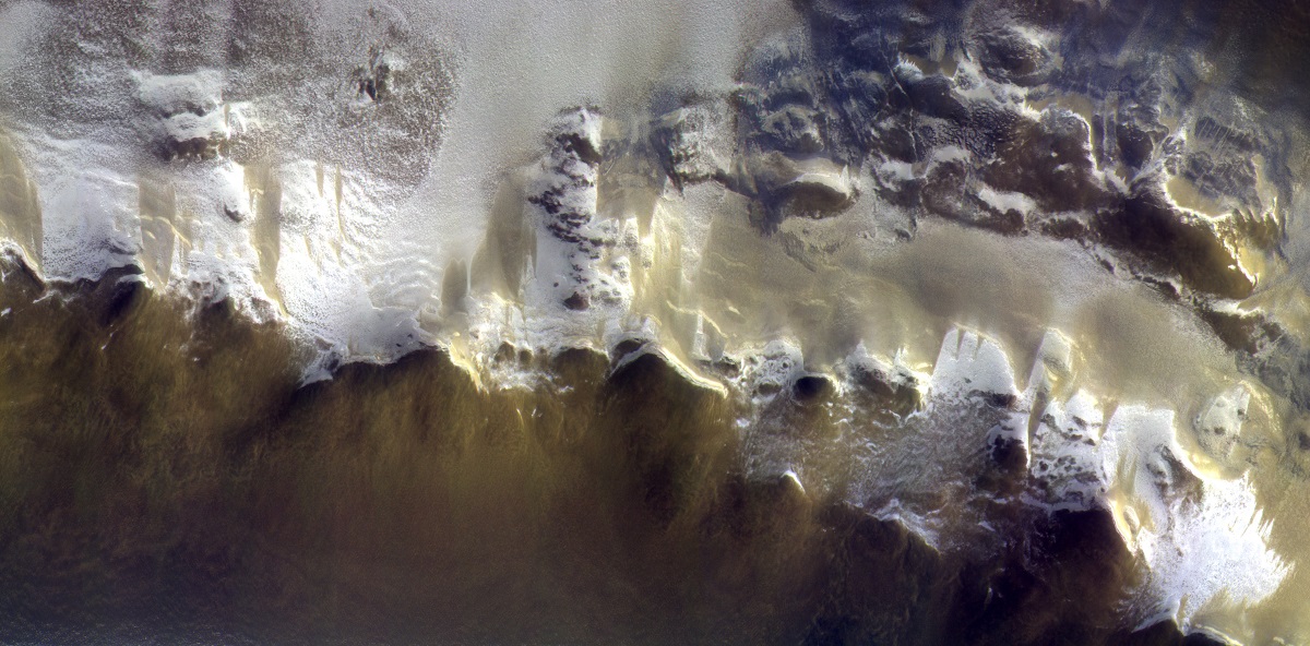
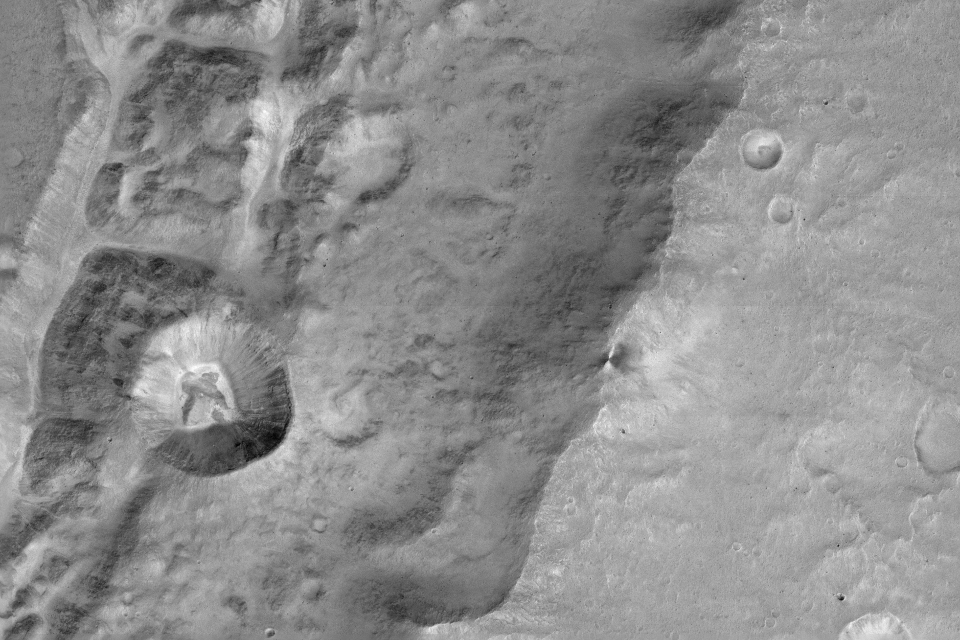
The image captured a 40 km- (25 mi) long segment of the Korolev Crater, which is located high in Mars’ northern hemisphere. The image was a composite of three images in different colors that were taken simultaneously on April 15th, 2018, which were then assembled to produce this color image. The bright material that appears at the edge of the crater is water ice.
The ExoMars Colour and Stereo Surface Imaging System, CaSSIS, captured this view of the rim of Korolev crater (73.3ºN/165.9ºE). Copyright ESA/Roscosmos/CaSSIS
As Antoine Pommerol, a member of the CaSSIS science team working on the calibration of the data, explained in a recent ESA press release:
“We were really pleased to see how good this picture was given the lighting conditions. It shows that CaSSIS can make a major contribution to studies of the carbon dioxide and water cycles on Mars.”
Prior to the test phase, the camera team transmitted new software to the TGO, and after a few minor issues, they determined that the instrument was ready to work. The camera is one of four instruments on the TGO, which also carries two spectrometer suites and a neutron detector. The spectrometers began their science mission on April 21st by taking the first sample of the atmosphere to see how its molecules absorb sunlight.
By doing this, the TGO hopes to determine the chemical composition of Mars atmosphere and find evidence of methane and other trace atmospheric gases that could be signatures of active biological or geological processes. Eventually, the camera will help characterize features on the surface that could be related to trace gas sources. Hence the importance of this recent test.
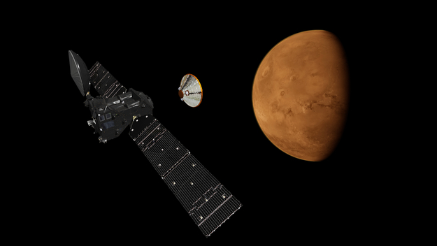
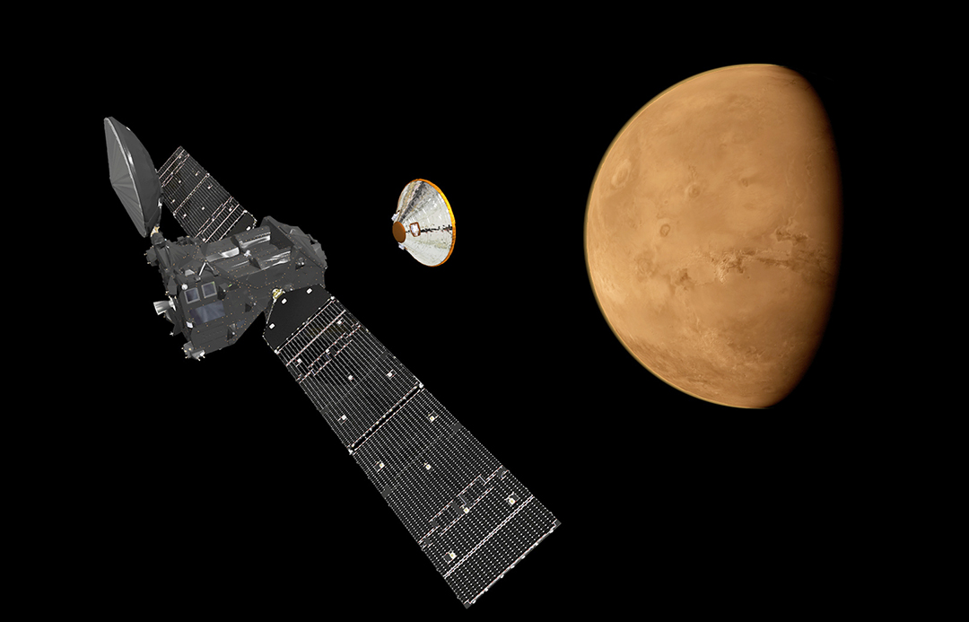
ExoMars’ Trace Gas Orbiter (TGO) and Schiaparelli lander seperating in orbit of Mars. Credit: ESA/ATG medialab
“We aim to fully automate the image production process,” said Nicolas Thomas, the camera’s principal investigator from the University of Bern. “Once we achieve this, we can distribute the data quickly to the science community for analysis.”
A lot of challenges lie ahead, which includes a long period of data collection to bring out the details of rare (or yet to be discovered) trace gases in Mars’ atmosphere. This is necessary since trace gases (as the name would suggest) are present in only very small amounts – i.e. less than 1% of the volume of the planet’s atmosphere. But as Håkan Svedhem – the ESA’s TGO project scientist – indicated, the test image was a good start.
“We are excited to finally be starting collecting data at Mars with this phenomenal spacecraft,” he said. “The test images we have seen so far certainly set the bar high.”
By 2020, the second part of the ExoMars mission is scheduled to launch. This will consist of a Russian surface platform and a European rover landing on the surface in support of a science mission that is expected to last into 2022 or longer. Alongside NASA’s proposed Mars 2020 rover, the Red Planet is due to have several more visitors in the coming years!
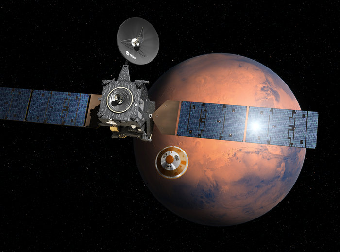
Artist’s impression depicting the separation of the ExoMars 2016 entry, descent and landing demonstrator module, named Schiaparelli, from the Trace Gas Orbiter, and heading for Mars. Credit: ESA/D. Ducros
In March of 2016, the European Space Agency (ESA) launched the ExoMars (Exobiology on Mars) mission into space. A joint project between the ESA and Roscosmos, this two-part mission consisted of the Trace Gas Orbiter (TGO) and the Schiaparelli lander, both of which arrived in orbit around Mars in October of 2016. While Schiaparelli crashed while attempting to land, the TGO has gone on to accomplish some impressive feats.
For example, in March of 2017, the orbiter commenced a series of aerobraking maneuvers, where it started to lower its orbit to enter Mars’ thin atmosphere and slow itself down. According to Armelle Hubault, the Spacecraft Operations Engineer on the TGO flight control team, the ExoMars mission has made tremendous progress and is well on its way to establishing its final orbit around the Red Planet.
TGO’s mission has been to study the surface of Mars, characterize the distribution of water and chemicals beneath the surface, study the planet’s geological evolution, identify future landing sites, and to search for possible biosignatures of past Martian life. Once it has established its final orbit around Mars – 400 km (248.5 mi) from the surface – the TGO will be ideally positioned to conduct these studies.
Visualization of the ExoMars mission’s Trace Gas Orbiter conducting aerobraking maneuvers to March of 2018. Credit: ESA
The ESA also released a graphic (shown above) demonstrating the successive orbits the TGO has made since it began aerobraking – and will continue to make until March of 2018. Whereas the red dot indicates the orbiter (and the blue line its current orbit), the grey lines show successive reductions in the TGO’s orbital period. The bold lines denote a reduction of 1 hour while the thin lines denote a reduction of 30 minutes.
Essentially, a single aerobraking maneuver consist of the orbiter passing into Mars’ upper atmosphere and relying on its solar arrays to generate tiny amounts of drag. Over time, this process slows the craft down and gradually lowers its orbit around Mars. As Armelle Hubault recently posted on the ESA’s rocket science blog:
“We started on the biggest orbit with an apocentre (the furthest distance from Mars during each orbit) of 33 200 km and an orbit of 24 hr in March 2017, but had to pause last summer due to Mars being in conjunction. We recommenced aerobraking in August 2017, and are on track to finish up in the final science orbit in mid-March 2018. As of today, 30 Jan 2018, we have slowed ExoMars TGO by 781.5 m/s. For comparison, this speed is more than twice as fast as the speed of a typical long-haul jet aircraft.”
Earlier this week, the orbiter passed through the point where it made its closest approach to the surface in its orbit (the pericenter passage, represented by the red line). During this approach, the craft dipped well into Mars’ uppermost atmosphere, which dragged the aircraft and slowed it down further. In its current elliptical orbit, it reaches a maximum distance of 2700 km (1677 mi) from Mars (it’s apocenter).
Visualization of the ExoMars Trace Gas Orbiter aerobraking at Mars. Credit: ESA/ATG medialab
Despite being a decades-old practice, aerobraking remains a significant technical challenge for mission teams. Every time a spacecraft passes through a planet’s atmosphere, its flight controllers need to make sure that its orientation is just right in order to slow down and ensure that the craft remains stable. If their calculations are off by even a little, the spacecraft could begin to spin out of control and veer off course. As Hubault explained:
“We have to adjust our pericentre height regularly, because on the one hand, the martian atmosphere varies in density (so sometimes we brake more and sometimes we brake less) and on the other hand, martian gravity is not the same everywhere (so sometimes the planet pulls us down and sometimes we drift out a bit). We try to stay at about 110 km altitude for optimum braking effect. To keep the spacecraft on track, we upload a new set of commands every day – so for us, for flight dynamics and for the ground station teams, it’s a very demanding time!”
The next step for the flight control team is to use the spacecraft’s thrusters to maneuver the spacecraft into its final orbit (represented by the green line on the diagram). At this point, the spacecraft will be in its final science and operation data relay orbit, where it will be in a roughly circular orbit about 400 km (248.5 mi) from the surface of Mars. As Hubault wrote, the process of bringing the TGO into its final orbit remains a challenging one.
“The main challenge at the moment is that, since we never know in advance how much the spacecraft is going to be slowed during each pericentre passage, we also never know exactly when it is going to reestablish contact with our ground stations after pointing back to Earth,” she said. “We are working with a 20-min ‘window’ for acquisition of signal (AOS), when the ground station first catches TGO’s signal during any given station visibility, whereas normally for interplanetary missions we have a firm AOS time programmed in advance.”
Artist’s impression of the ESA’s Exomars 2020 rover, which is expected to land on the surface of Mars by the Spring of 2o21. Credit:ESA
With the spacecraft’s orbital period now shortened to less than 3 hours, the flight control team has to go through this exercise 8 times a day now. Once the TGO has reached its final orbit (by March of 2018), the orbiter will remain there until 2022, serving as a telecommunications relay satellite for future missions. One of its tasks will be to relay data from the ESA’s ExoMars 2020 mission, which will consist of a European rover and a Russian surface platform being deployed the surface of Mars in the Spring of 2021.
Along with NASA’s Mars 2020 rover, this rover/lander pair will be the latest in a long line of robotic missions looking to unlock the secrets of Mars past. In addition, these missions will conduct crucial investigations that will pave the way for eventual sample return missions to Earth, not to mention crewed to the surface!
Scientists from the OU have discovered a new phenomenon that could explain the long-debated mystery of how recent land features on Mars are formed in the absence of significant amounts of water. Credit: OUNews
Mars modern landscape is something of a paradox. It’s many surface features are very similar to those on Earth that are caused by water-borne erosion. But for the life of them, scientists cannot imagine how water could have flown on Mars’ cold and desiccated surface for most of Mars’ history. Whereas Mars was once a warmer, wetter place, it has had a very thin atmosphere for billions of years now, which makes water flow and erosion highly unlikely.
In fact, while the surface of Mars periodically becomes warm enough to allow for ice to thaw, liquid water would boil once exposed to the thin atmosphere. However, in a new study led by an international team of researchers from the UK, France and Switzerland, it has been determined that a different kind of transport process involving the sublimation of water ice could have led to the Martian landscape becoming what it is today.
The study, which was led Dr. Jan Raack – a Marie Sklodowska-Curie Research Fellow at The Open University – was recently published in the scientific journal Nature Communications. Titled “Water Induced Sediment Levitation Enhances Downslope Transport on Mars”, this research study consisted of experiments that tested how processes on Mars’ surface could allow water transport without it being in liquid form.
Reull Vallis, the river-like structure captured by the ESA’s Mars Express probe, is believed to have formed when running water flowed in the distant martian past. Credit and copyright: ESA/DLR/FU Berlin (G. Neukum)
To conduct their experiments, the team used the Mars Simulation Chamber, an instrument at The Open University that is capable of simulating the atmospheric conditions on Mars. This involved lowering the atmospheric pressure inside the chamber to what is normal for Mars – about 7 mbar, compared to 1000 mbar (1 bar or 100 kilopascals) here on Earth – while also adjusting temperatures.
On Mars, temperatures range from a low of -143 °C (-255 °F) during winter at the poles to a high of 35 °C (95 °F) at the equator during midday in the summer. Having recreated these conditions, the team found that when water ice exposed to the simulated Martian atmosphere, it would not simply melt. Instead, it would become unstable and begin violently boiling off.
However, the team also found that this process would be capable of moving large amounts of sand and sediment, which would effectively “levitate” on the boiling water. This means that, compared to Earth, relatively small amounts of liquid water are capable of moving sediment across the surface of Mars. These levitating pockets of sand and debris would be capable of forming tje large dunes, gullies, recurring slope lineae, and other features observed on Mars.
In the past, scientists have indicated how these features were the result of sediment transportation down slopes, but were unclear as to the mechanisms behind them. As Dr. Jan Raack explained in a OUNews press release:
“Our research has discovered that this levitation effect caused by boiling water under low pressure enables the rapid transport of sand and sediment across the surface. This is a new geological phenomenon, which doesn’t happen on Earth, and could be vital to understanding similar processes on other planetary surfaces.”
Illustration of the ESA Exomars 2020 Rover, which will explore the Red Planet in search for signs of ancient life. Credit:ESA
Through these experiments, Dr. Raack and his colleagues were able to shed light on how conditions on Mars could allow for features that we tend to associate with flowing water here on Earth. In addition to helping to resolve a somewhat contentious debate concerning Mars’ geological history and evolution, this study is also significant when it comes to future exploration missions.
Dr. Raack acknowledges the need for more research to confirm their study’s conclusions, and indicated that the ESA’s ExoMars 2020 Rover will be well-situated to conduct it once it is deployed :
“This is a controlled laboratory experiment, however, the research shows that the effects of relatively small amounts of water on Mars in forming features on the surface may have been widely underestimated. We need to carry out more research into how water levitates on Mars, and missions such as the ESA ExoMars 2020 Rover will provide vital insight to help us better understand our closest neighbour.”
One of the first images from the Mars Camera, CaSSIS, on the ExoMars Trace Gas Orbiter. The image shows a 1.4 km sized crater (left center) on the rim of a much larger crater near the Mars equator. Credit: ESA/Roscosmos/ExoMars/CaSSIS/UniBE.
The first images taken by the newest mission to Mars have been released, and the teams behind the instruments on ESA’s ExoMars Trace Gas Orbiter are ecstatic.
“The first images we received are absolutely spectacular – and it was only meant to be a test,” said Nicolas Thomas, who leads the Colour and Stereo Surface Imaging System at the University of Bern.
“A lot of public attention has been on the failed landing of Schiaparelli,” said Thomas, “but TGO has been working really well so we have been extremely busy in the past month.”
Scientists and engineers have been turning on and checking out the various instruments on TGO as it orbits in an initial elliptical orbit that takes it from just 250 km above the surface of Mars to nearly 100,000 km every 4.2 days.
During November 20-28 it spent two orbits testing its four science instruments for the first time and making important calibration measurements. A total of 11 images were returned during the first close fly-by during that period, which you can see in the video below.
The views show Hebes Chasma, an 8 km-deep trough in the northern most part of Valles Marineris, during the spacecraft’s closest approach.
“We saw Hebes Chasma at 2.8 metres per pixel” Thomas said. “That’s a bit like flying over Bern at 15,000 km per hour and simultaneously getting sharp pictures of cars in Zurich.”
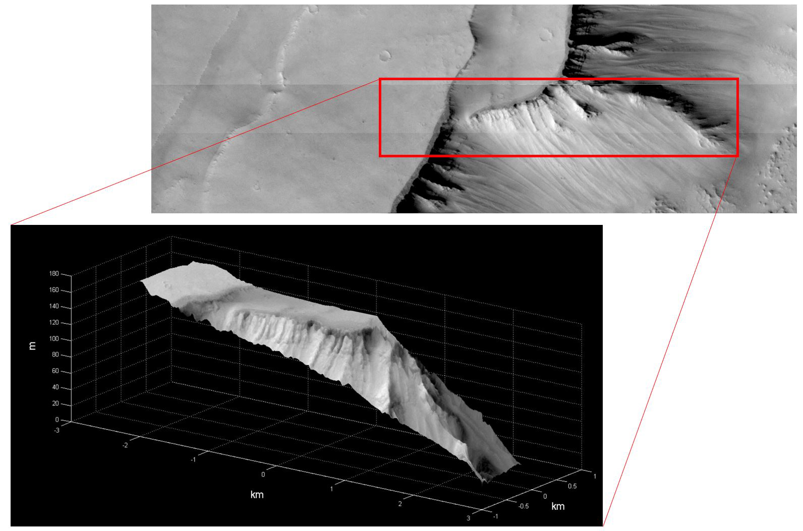
The first stereo reconstruction of a small area in Noctis Labyrinthus. The image gives an altitude map of the region with a resolution of less than 20 meters. Credit: ESA/Roscosmos/ExoMars/CaSSIS/UniBE
The team tested the color and stereo capabilities of CaSSIS were also successfully tested. Below is a 3D reconstruction of a region called Noctis Labyrinthus that was produced from a stereo pair of images. This region is also part of Valles Marineris and has a system of deep, steep-walled valleys.
Thomas said these first images don’t show much color because the surfaces in this area are covered with dust so there are few color changes evident. “We will have to wait a little until something colourful passes under the spacecraft,” he said. Until then, the pictures will be black and white.
The ExoMars 2016 mission is a collaboration between the European Space Agency (ESA) and Roscosmos. ExoMars will continue the search for biological and geologic activity on Mars, which may have had a much warmer, wetter climate in the past. The TGO orbiter is equipped with a payload of four science instruments supplied by European and Russian scientists that will investigate the source and precisely measure the quantity of the methane and other trace gases.
Methane provides the most interest because it has been detected periodically on Mars. On Earth, methane is produced primarily by biological activity, and to a smaller extent by geological processes such as some hydrothermal reactions.
First detection of atmospheric carbon dioxide by the ExoMars Trace Gas Orbiter’s Atmospheric Chemistry Suite. Credit: ESA/Roscosmos/ExoMars/ACS/IKI.
The two instruments that will be used to look for methane and other gases were also tested. During the test observations last week, the Atmospheric Chemistry Suite focused on carbon dioxide, which makes up a large volume of the planet’s atmosphere, while the Nadir and Occultation for Mars Discovery instrument looked for water.
The teams also coordinated observations with ESA’s Mars Express and NASA’s Mars Reconnaissance Orbiter, as they will do future corresponding observations during the mission.
Starting in March, 2017, TGO will use Mars atmosphere to perform aerobraking to gradually slow the spacecraft down to reach a roughly circular orbit 400 km above Mars. The aerobraking process will take between 9-12 months, with the primary science phase will beginning near the end of 2017.
The CaSSIS camera team said nominal operations will have the instrument acquiring 12-20 high resolution stereo and color images of selected targets per day.
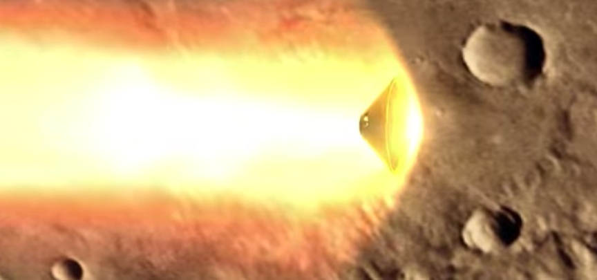
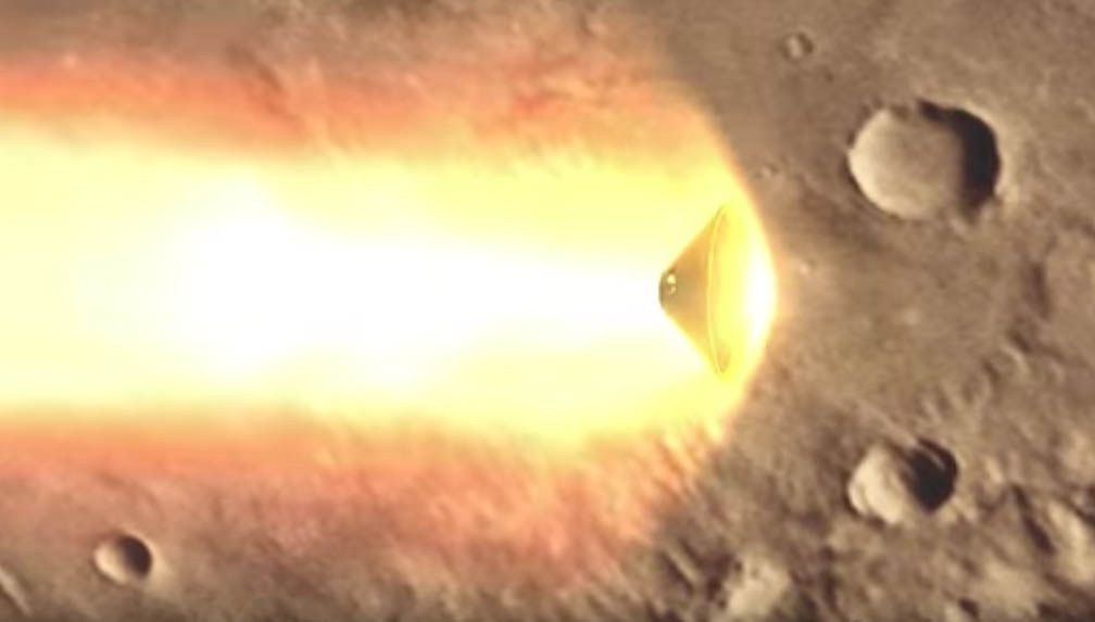
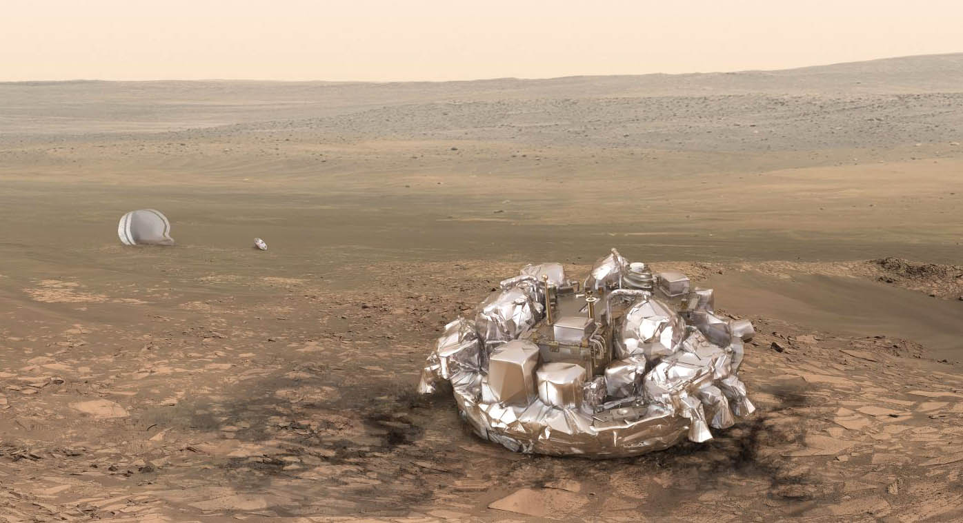
Credit: Schiaparelli lander protected by its heat shield as it enters the Martian atmosphere. Credit: ESA
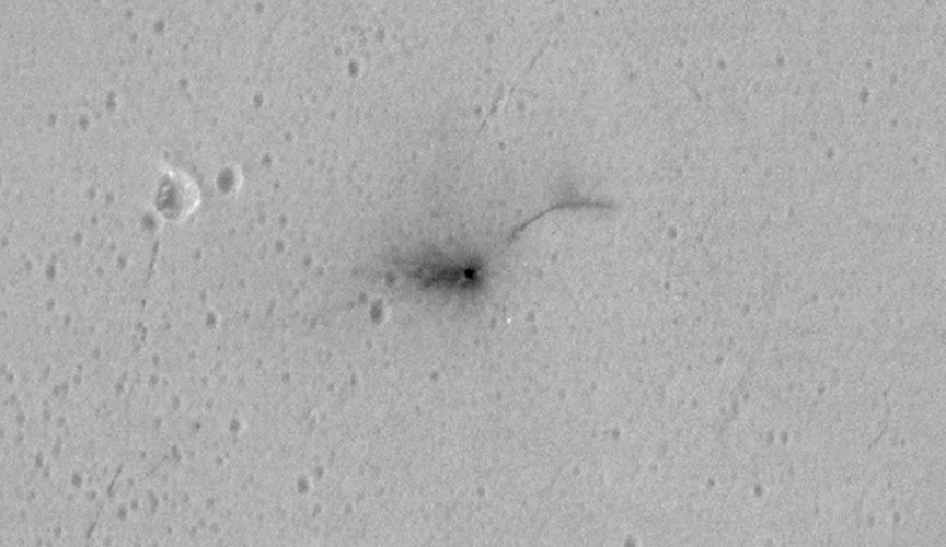
A closeup of the dark, approximately circular crater about 7.9 feet (2.4 meters) in diameter that marks the crash of the Schiaparelli test lander on Mars. The new, higher-resolution photo was taken on October 25 by NASA’s Mars Reconnaissance Lander (MRO). A hint of an upraised rim is visible along the crater’s lower left side. The tiny white specks may be pieces of the lander that broke away on impact. The odd dark curving line has yet to be explained. Credit: NASA/JPL-Caltech
What’s the most powerful telescope for observing Mars? A telephoto lens on the HiRise camera on the Mars Reconnaissance Orbiter that can resolve features as small as 3 feet (1-meter) across. NASA used that camera to provide new details of the scene near the Martian equator where Europe’s Schiaparelli test lander crashed to the surface last week.
The Schiaparelli test lander was protected by its heat shield as it descended through the Martian atmosphere at high speed. Credit: ESA
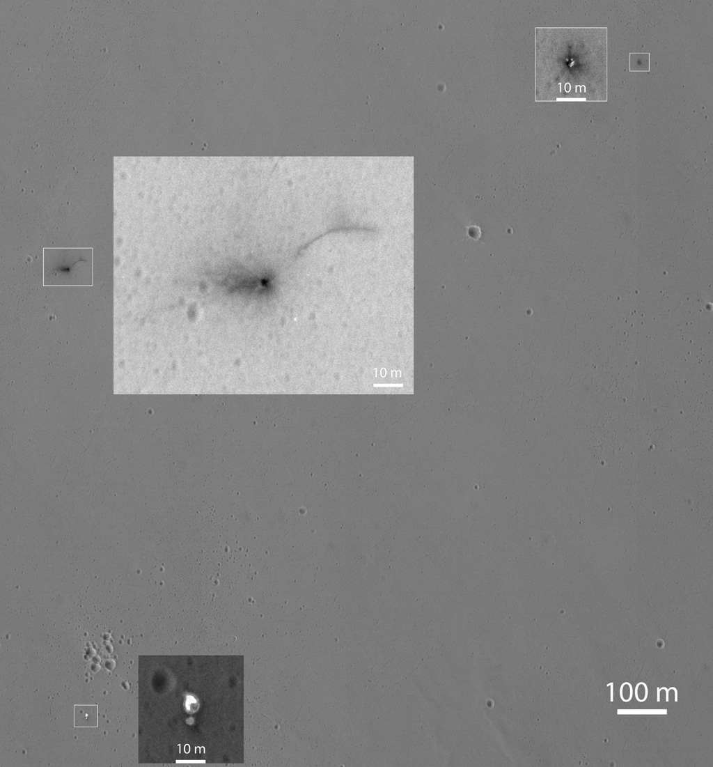
During an October 25 imaging run HiRise photographed three locations where hardware from the lander hit the ground all within about 0.9 mile (1.5 kilometers) of each other. The dark crater in the photo above is what you’d expect if a 660-pound object (lander) slammed into dry soil at more than 180 miles an hour (300 km/h). The crater’s about a foot and a half (half a meter) deep and haloed by dark rays of fresh Martian soil excavated by the impact.
But what about that long dark arc northeast of the crater? Could it have been created by a piece of hardware jettisoned when Schiaparelli’s propellant tank exploded? The rays are curious too. The European Space Agency says that the lander fell almost vertically when the thrusters cut out, yet the asymmetrical nature of the streaks — much longer to the west than east — would seem to indicate an oblique impact. It’s possible, according to the agency, that the hydrazine propellant tanks in the module exploded preferentially in one direction upon impact, throwing debris from the planet’s surface in the direction of the blast, but more analysis is needed. Additional white pixels in the image could be lander pieces or just noise.
This Oct. 25, 2016, image shows the area where the European Space Agency’s Schiaparelli test lander reached the surface of Mars, with magnified insets of three sites where components of the spacecraft hit the ground. It is the first view of the site from the High Resolution Imaging Science Experiment (HiRISE) camera on NASA’s Mars Reconnaissance Orbiter taken after the Oct. 19, 2016, landing event and our highest resolution of the scene to date. Click for a full-resolution image. Credit: NASA/JPL-Caltech
In the wider shot, several other pieces of lander-related flotsam are visible. About 0.8 mile (1.4 km) eastward, you can see the tiny crater dug out when the heat shield smacked the ground. Several bright spots might be pieces of its shiny insulation. About 0.6 mile (0.9 kilometer) south of the lander impact site, two features side-by-side are thought to be the spacecraft’s parachute and the back shell. NASA plans additional images to be taken from different angle to help better interpret what we see.
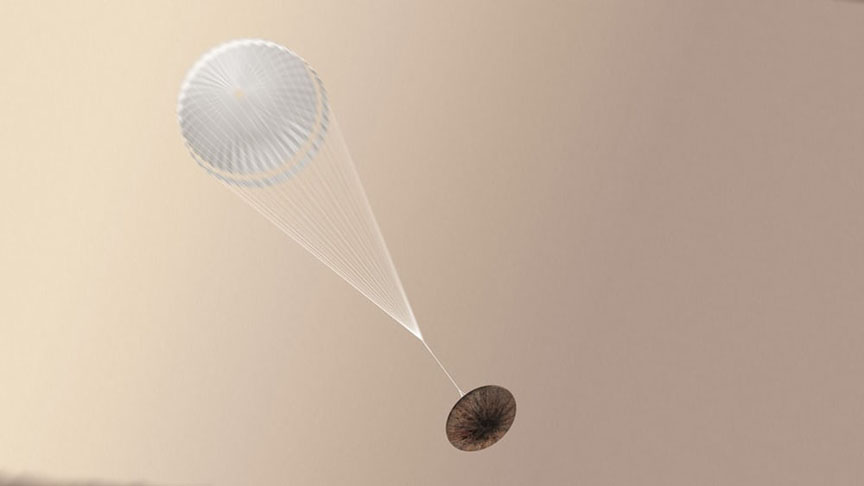
Schiaparelli dangles from its parachute in this artist’s view. A software error caused the chute to deploy too soon. Credit: ESA
The test lander is part of the European Space Agency’s ExoMars 2016 mission, which placed the Trace Gas Orbiter into orbit around Mars on Oct. 19. The orbiter will investigate the atmosphere and surface of Mars in search of organic molecules and provide relay communications capability for landers and rovers on Mars. Science studies won’t begin until the spacecraft trims its orbit to a 248-mile-high circle through aerobraking, which is expected to take about 13 months.
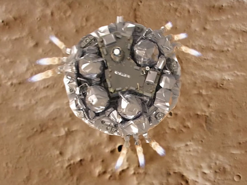
Everything started out well with Schiaparelli, which successfully transmitted data back to Earth during its descent through the atmosphere, the reason we know that the heat shield separated and the parachute deployed as planned. Unfortunately, the chute and its protective back shell ejected ahead of time followed by a premature firing of the thrusters. And instead of burning for the planned 30 seconds, the rockets shut off after only 3. Why? Scientists believe a software error told the lander it was much closer to the ground than it really was, tripping the final landing sequence too early.
Landing on Mars has never been easy. We’ve done flybys, attempted to orbit the planet or land on its surface 44 times. 15 of those have been landing attempts, with 7 successes: Vikings 1 and 2, Mars Pathfinder, the Spirit and Opportunity rovers, the Phoenix Lander and Curiosity rover. We’ll be generous and call it 8 if you count the 1971 landing of Mars 3 by the then-Soviet Union. It reached the surface safely but shut down after just 20 seconds.
Mars can be harsh, but it forces us to get smart.
**** Want to learn more about Mars and how to track it across the sky? My new book, Night Sky with the Naked Eye, which will be published on Nov. 8, covers planets, satellites, the aurora and much more. You can pre-order it right now at these online stores. Just click an icon to go to the site of your choice – Amazon, Barnes & Noble or Indiebound. It’s currently available at the first two outlets for a very nice discount.
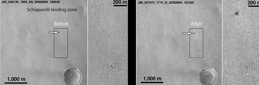
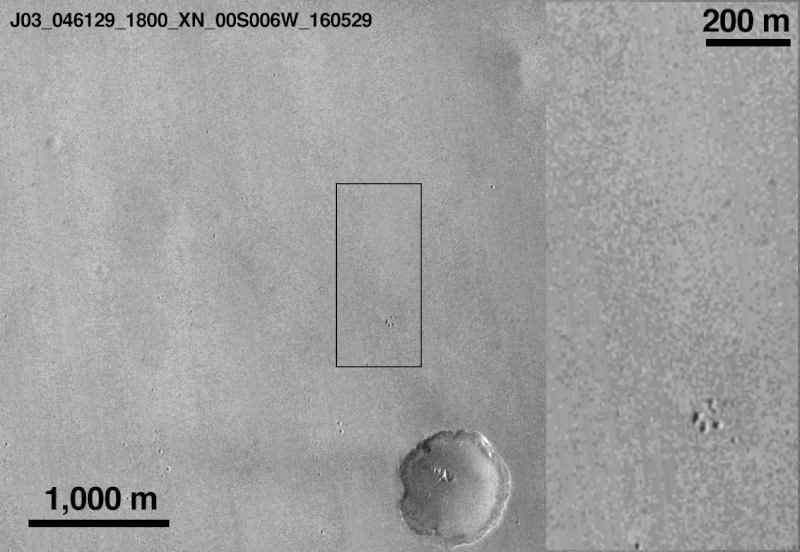
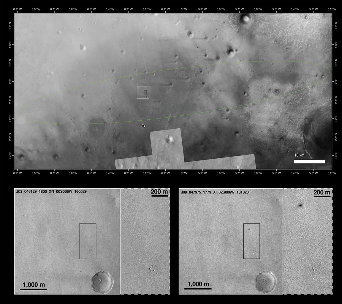
Mars Reconnaissance Orbiter view of Schiaparelli landing site before and after the lander arrived. The images have a resolution of 6 meters per pixel and shows two new features on the surface when compared to an image from the same camera taken in May this year. The black dot appears to be the lander impact site and the smaller white dot below the paw-shaped cluster of craters, the parachute. Credit: NASA
Mars Reconnaissance Orbiter view of Schiaparelli landing site before and after the lander arrived. The images have a resolution of 6 meters per pixel and shows two new features on the surface when compared to an image from the same camera taken in May this year. The black dot appears to be the lander impact site and the smaller white dot below the paw-shaped cluster of craters, the parachute. Credit: NASA
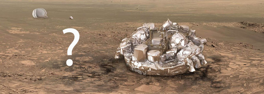
Instead of a controlled descent to the surface using its thrusters, ESA’s Schiaparelli lander hit the ground hard and may very well have exploded on impact. NASA’s Mars Reconnaissance Orbiter then-and-now photos of the landing site have identified new markings on the surface of the Red Planet that are believed connected to the ill-fated lander.
Schiaparelli entered the martian atmosphere at 10:42 a.m. EDT (14:42 GMT) on October 19 and began a 6-minute descent to the surface, but contact was lost shortly before expected touchdown seconds after the parachute and back cover were discarded. One day later, the Mars Reconnaissance Orbiter took photos of the expected touchdown site as part of a planned imaging run.
The landing site is shown within the Schiaparelli landing ellipse (top) along with before and after images below. Copyright Main image: NASA/JPL-Caltech/MSSS, Arizona State University; inserts: NASA/JPL-Caltech/MSSS
One of the features is bright and can be associated with the 39-foot-wide (12-meter) diameter parachute used in the second stage of Schiaparelli’s descent. The parachute and the associated back shield were released from Schiaparelli prior to the final phase, during which its nine thrusters should have slowed it to a standstill just above the surface.
The other new feature is a fuzzy dark patch or crater roughly 50 x 130 feet (15 x 40 meters) across and about 0.6 miles (1 km) north of the parachute. It’s believed to be the impact crater created by the Schiaparelli module following a much longer free fall than planned after the thrusters were switched off prematurely.
Artist’s concept of Schiaparelli deploying its parachute. The parachute may also have played a role in the crash. It may have deployed too soon, causing the thrusters to fire too soon. The thrusters may also have simply cut out too soon after firing. Credit: ESA
Mission control estimates that Schiaparelli dropped from between 1.2 and 2.5 miles (2 and 4 km) altitude, striking the Martian surface at more than 186 miles an hour (300 km/h). The dark spot is either disturbed surface material or it could also be due to the lander exploding on impact, since its thruster propellant tanks were likely still full. ESA cautions that these findings are still preliminary.
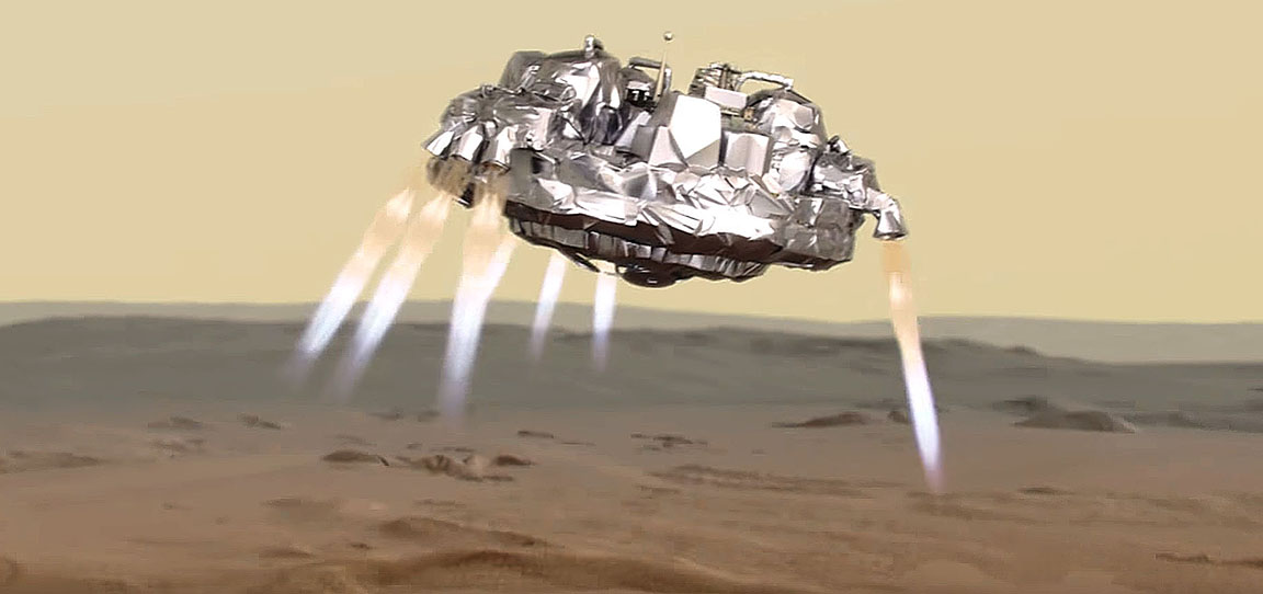
Something went wrong with Schiaparelli’s one or more sets of thrusters during the descent, causing the lander to crash on the surface at high speed. Credit: ESA
Since the module’s descent trajectory was observed from three different locations, the teams are confident that they will be able to reconstruct the chain of events with great accuracy. Exactly what happened to cause the thrusters to shut down prematurely isn’t yet known.
This artist's view shows the European Space Agency's Schiaparelli lander on Mars. It's unclear whether the landing was successful. Signals were received during its descent but then suddenly cut off. Mission control is working on the data now and will have an update on the status of the probe tomorrow morning Oct. 20. Credit: ESA/ATG medialab
This artist’s view shows the European Space Agency’s Schiaparelli lander on Mars. It’s unclear whether the landing was successful. Signals were received during its descent but then suddenly cut off. Mission control is working on the data now and will have an update on the status of the probe tomorrow morning Oct. 20. Credit: ESA/ATG medialab
Good news and bad news. First the good. After a seven-month and 300 million mile (483 million km) journey, the Trace Gas Orbiter (TGO) successfully achieved orbit around Mars today. A signal spike appeared out of the noise about 12:35 p.m. EDT to great applause and high-fives at ESA’s European Space Operations Center in Darmstadt, Germany.
Joy in the control room when the signal from the Trace Gas Orbiter was received this morning, signaling that the spacecraft had achieved orbit around Mars. Credit: ESA Livestream
Two hours later, news of the lander arrived. Not so good but to be fair, it’s still too early to tell. Schiaparelli broadcast a signal during its descent to the Red Planet that was received here on Earth and by the orbiting Mars Express. All well and good. But then mid-transmission, the signal cut out.
Paolo Ferri, head of ESA’s mission operations department, called the news “not good signs” but promised that his team would be analyzing the data through the night to determine the status of the lander. Their findings will be shared around mid-morning Friday Central European Time (around 5 a.m. EDT).
Three days ago, Schiaparelli separated from the orbiter and began a three-day coast to Mars. It entered the atmosphere today at an altitude of 76 miles (122 km) and speed of 13,049 mph (21,000 km/hr), protected from the hellish heat of re-entry by an aerodynamic heat shield.
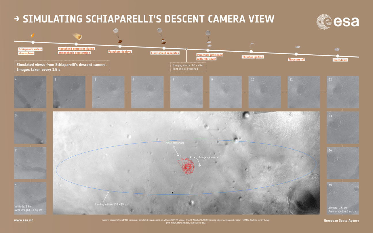
Simulated sequence of the 15 images that the descent camera Schiaparelli module should have taken during its descent to Mars this morning. In the simulated images shown here, the first was made from 3 km up. The camera had planned to take images every 1.5 seconds with the final image in this at ~1.5 km. Depending on Schiaparelli’s actual descent speed, the final image may have been snapped closer to the surface. The views were generated from images taken by NASA’s Mars Reconnaissance Orbiter of the center of Schiaparelli’s landing ellipse, and represent the views expected at each altitude. Copyright spacecraft: ESA/ATG medialab; simulated views from NASA images (credit: NASA/JPL/MRO); landing ellipse background image: Mars Odyssey; simulation: ESA
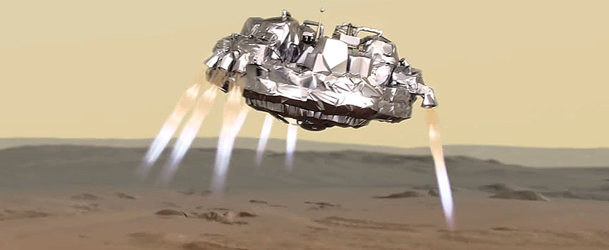
If all went well, at 6.8 miles (11 km) altitude, it would have deployed its parachute and moments later, dropped the heat shield. At 0.7 miles (1.2 km) above the surface, the lander would have jettisoned the chute and rear protective cover and fired its nine retrorockets while plummeting to the surface at 155 mph (255 mph). 29 seconds later, the thrusters would have shut off with Schiaparelli dropping the remaining 6.5 feet (2 meters) to the ground. Total elapsed time: just under 6 minutes.
For now, have hope. Given that Schiaparelli was primarily a test of landing technologies for future Mars missions, whatever happened, everything we learn from this unexpected turn of events will be invaluable. You can continue to follow updates on ESA’s Livestream.
** Update Oct. 20: It appears that the thrusters on Schiaparelli may have cut out too soon, causing the lander to drop from a higher altitude. In addition, the ejection of the parachute and back heat shield may have happened earlier than expected.
This from ESA:
“The data have been partially analyzed and confirm that the entry and descent stages occurred as expected, with events diverging from what was expected after the ejection of the back heat shield and parachute. This ejection itself appears to have occurred earlier than expected, but analysis is not yet complete.
The thrusters were confirmed to have been briefly activated although it seems likely that they switched off sooner than expected, at an altitude that is still to be determined.”
Artist's view of the Schiaparelli lander descending to Mars on October 19. Credit: ESA
Watch how Schiaparelli will land on Mars. Touchdown will occur at 10:48 a.m. EDT (14:48 GMT) Wednesday Oct. 19.
Cross your fingers for good weather on the Red Planet on October 19. That’s the day the European Space Agency’s Schiaparelli lander pops open its parachute, fires nine, liquid-fueled thrusters and descends to the surface of Mars. Assuming fair weather, the lander should settle down safely on the wide-open plains of Meridiani Planum near the Martian equator northwest of NASA’s Opportunity rover. The region is rich in hematite, an iron-rich mineral associated with hot springs here on Earth.
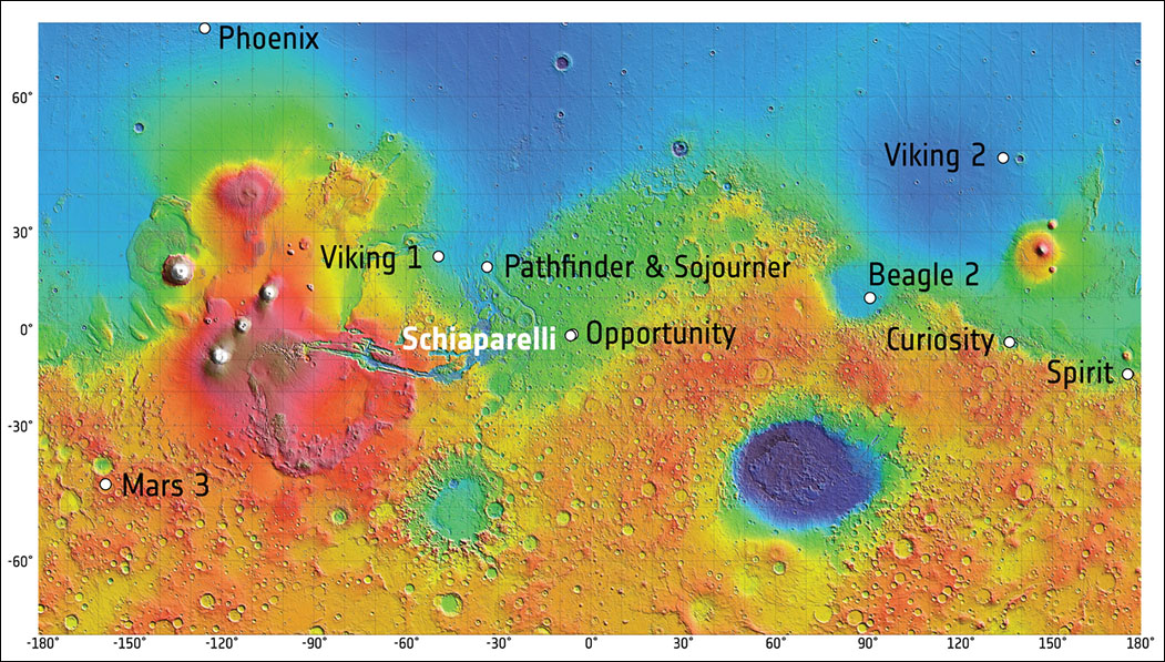
On Wednesday, October 19, the ExoMars 2016 entry, descent and landing demonstrator module, named Schiaparelli, will land on Mars in Meridiani Planum not far from the Opportunity rover. The map shows the seven rovers and landers that have reached the surface of Mars and successfully operated there. The background image is a shaded relief map of Mars created using data from NASA’s Mars Global Surveyor spacecraft.
The 8-foot-wide probe will be released three days earlier from the Trace Gas Orbiter (TGO) and coast toward Mars before entering its atmosphere at 13,000 mph (21,000 km/hr). During the 6-minute-long descent, Schiaparelli will decelerate gradually using the atmosphere to brake its speed, a technique called aerobraking. Not only is Meridiani Planum flat, it’s low, which means the atmosphere is thick enough to allow Schiaparelli’s heat shield to reduce its speed sufficiently so the chute can be safely deployed. The final firing of its thrusters will ensure a soft and controlled landing.
Artist’s impression showing Schiaparelli separating from the Trace Gas Orbiter and heading for Mars. The lander is named for late 19th century Italian astronomer Giovanni Schiaparelli, who created a detailed telescopic map of Mars. The orbiter will sniff out potentially biological gases such as methane in Mars’ atmosphere and track its sources and seasonal variations. Credit: ESA/ATG medialab
The lander is one-half of the ExoMars 2016 mission, a joint venture between the European Space Agency and Russia’s Roscosmos. The Trace Gas Orbiter (TGO) will fire its thrusters to place itself in orbit about the Red Planet the same day Schiparelli lands. Its job is to inventory the atmosphere in search of organic molecules, methane in particular. Plumes of methane, which may be biological or geological (or both) in origin, have recently been detected at several locations on Mars including Syrtis Major, the planet’s most prominent dark marking. The orbiter will hopefully pinpoint the source(s) as well as study seasonal changes in locations and concentrations.
This image, taken by ESA’s Express spacecraft, shows what appears to be a dust-covered frozen sea near the Martian equator. Located in Elysium Planitia, the flat plain is covered with irregular blocky shapes. They look just like the rafts of fragmented sea ice that lie off the coast of Antarctica on Earth. Raised levels of methane were detected here by ESA’s Mars Express orbiter. Copyright: ESA/DLR/FU Berlin (G. Neukum)
Methane (CH4) has long been associated with life here on Earth. More than 90% of the colorless, odorless gas is produced by living organisms, primarily bacteria. Sunlight breaks methane down into other gases over a span of about 300 years. Because the gas relatively short-lived, seeing it on Mars implies an active, current source. There may be several:
Long-extinct bacteria that released methane that became trapped in ice or minerals in the upper crust. Changing temperature and pressure could stress the ice and release that ancient gas into today’s atmosphere.
Bacteria that are actively producing methane to this day.
Abiological sources. Iron can combine with oxygen in terrestrial hot springs and volcanoes to create methane. This gas can also become trapped in solid forms of water or ‘cages’ called clathrate hydrates that can preserve it for a long time. Olivine, a common mineral on Earth and Mars, can react with water under the right conditions to form another mineral called serpentine. When altered by heat, water and pressure, such in environments such as hydrothermal springs, serpentine can produce methane.
Will it turn out to be burping bacteria or mineral processes? Let’s hope TGO can point the way.
This image illustrates possible ways methane might get into Mars’ atmosphere and also be removed from it: microbes (left) under the surface that release the gas into the atmosphere, weathering of rock (right) and stored methane ice called a clathrate. Ultraviolet light can work on surface materials to produce methane as well as break it apart into other molecules (formaldehyde and methanol) to produce carbon dioxide. Credit: NASA/JPL-Caltech/SAM-GSFC/Univ. of Michigan
The Trace Gas Orbiter will also use the Martian atmosphere to slow its speed and trim its orbital loop into a 248-mile-high (400 km) circle suitable for science observations. But don’t expect much in the way of scientific results right away; aerobraking maneuvers will take about a year, so TGO’s job of teasing out atmospheric ingredients won’t begin until December 2017. The study runs for 5 years.
The orbiter will also examine Martian water vapor, nitrogen oxides and other organics with far greater accuracy than any previous probe as well as monitor seasonal changes in the atmosphere’s composition and temperature. And get this — its instruments can map subsurface hydrogen, a key ingredient in both water and methane, down to a depth of a meter (39.4 inches) with greater resolution compared to previous studies. Who knows? We may discover hidden ice deposits or methane sinks that could influence where future rovers will land. Additional missions to Mars are already on the docket, including ExoMars 2020. More about that in a minute.
This artist’s view shows Schiaparelli, the entry, descent and landing demonstrator module, using its thrusters to make a soft landing on Mars on October 19 at 10:48 a.m. EDT (14:48 GMT). Credit: ESA/ATG medialab
While TGO’s mission will require years, the lander is expected to survive for only four Martian days (called ‘sols’) by using the excess energy capacity of its batteries. A set of scientific sensors will measure wind speed and direction, humidity, pressure and electric fields on the surface. A descent camera will take pictures of the landing site on the way down; we’ll should see those photos the very next day. Data and imagery from the lander will be transmitted to ESA’s Mars Express and a NASA Relay Orbiter, then relayed to Earth.
This animation shows the paths of the Trace Gas Orbiter and Schiaparelli lander on Oct. 19 when they arrive at Mars.
If you’re wondering why the lander’s mission is so brief, it’s because Schiaparelli is essentially a test vehicle. Its primary purpose is to test technologies for landing on Mars including the special materials used for protection against the heat of entry, a parachute system, a Doppler radar device for measuring altitude and liquid-fueled braking thrusters.
Martian dust storms can be cause for concern during any landing attempt. Since it’s now autumn in the planet’s northern hemisphere, a time when storms are common, there’s been some finger-nail biting of late. The good news is that storms of recent weeks have calmed and Mars has entered a welcome quiet spell.
To watch events unfold in real time, check out ESA’s live stream channel,Facebook pageand Twitter updates. The announcement of the separation of the lander from the orbiter will be made around 11 a.m. Eastern Time (15:00 GMT) Sunday October 16. Live coverage of the Trace Gas Orbiter arrival and Schiaparelli landing on Mars runs from 9-11:15 a.m. Eastern (13:00-15:15 GMT) on Wednesday October 19.Photos taken by Schiaparelli’s descent camera will be available starting at 4 a.m. Eastern (8:00 GMT) on October 20. More details here.We’ll also keep you updated on Universe Today.
The ExoMars 2016 mission will pave the way for a rover mission to the Red Planet in 2020. Credit: ESA
Everything we learn during the current mission will be applied to planning and executing the next — ExoMars 2020, slated to launch in 2020. That venture will send a rover to the surface to search and chemically test for signs of life, present or past. It will collect samples with a drill at various depths and analyze the fines for bio-molecules. Getting down deep is important because the planet’s thin atmosphere lets through harsh UV light from the sun, sterilizing the surface.
Are you ready for adventure? See you on Mars (vicariously)!
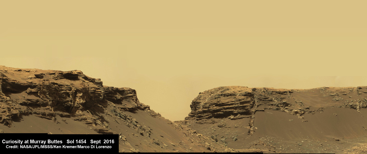
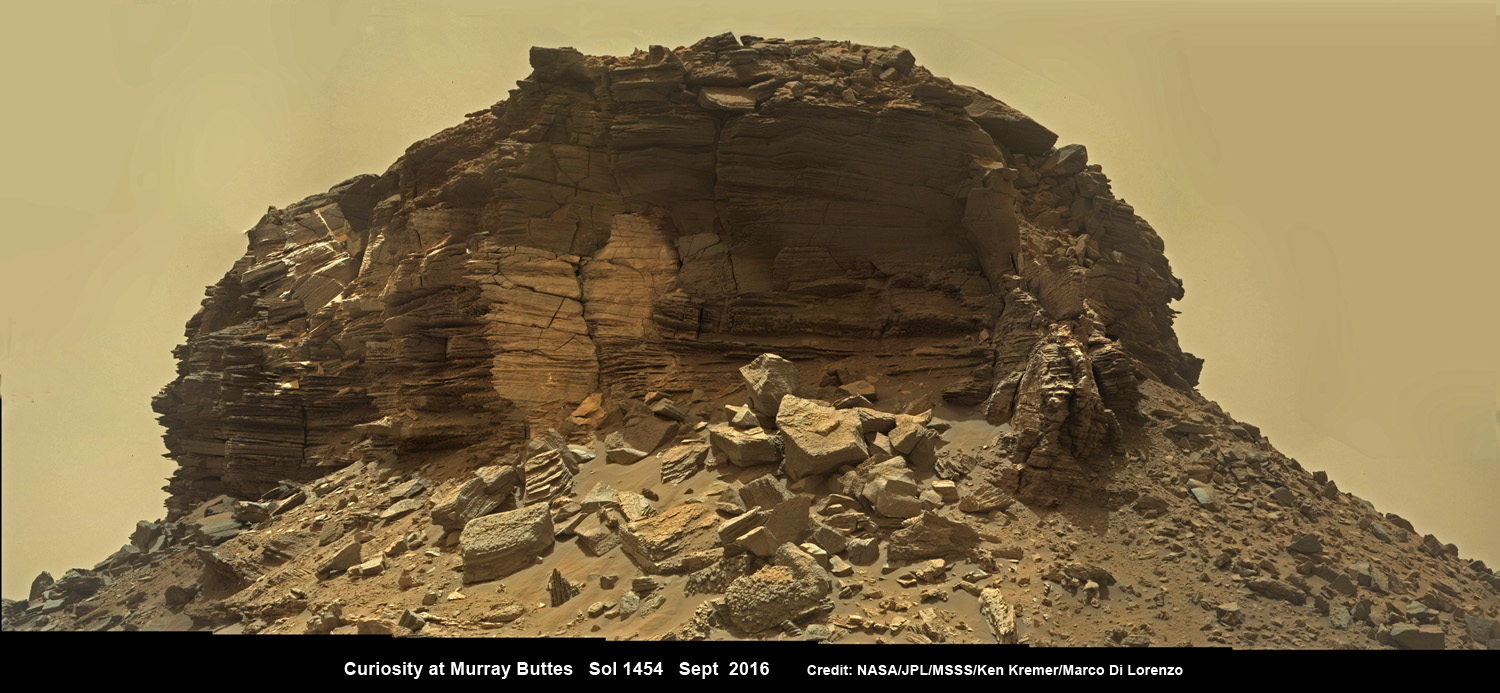
Dramatic hillside view showing sloping buttes and layered outcrops within of the Murray Buttes region on lower Mount Sharp from the Mast Camera (Mastcam) on NASA's Curiosity Mars rover. This photo mosaic is stitched and cropped from Mastcam camera raw images taken on Sol 1454, Sept. 8, 2016, with added artificial sky. Credit: NASA/JPL/MSSS/Ken Kremer/kenkremer.com/Marco Di Lorenzo
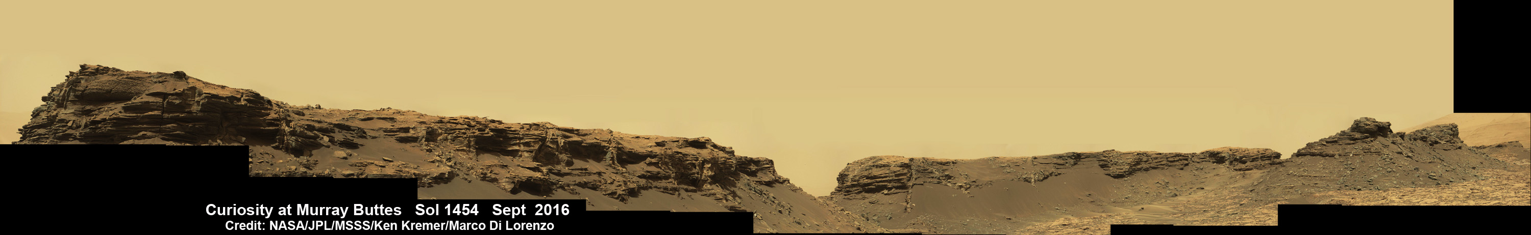
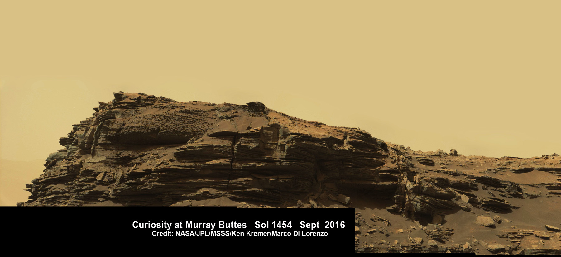
Spectacular wide angle mosaic view showing sloping buttes and layered outcrops within the Murray Buttes region on lower Mount Sharp from the Mast Camera (Mastcam) on NASA’s Curiosity Mars rover. This photo mosaic is stitched from Mastcam camera raw images taken on Sol 1454, Sept. 8, 2016 with added artificial sky. Credit: NASA/JPL/MSSS/Ken Kremer/kenkremer.com/Marco Di Lorenzo
The most stunning panoramic vistas likely ever snapped by NASA’s Curiosity rover reveal spectacularly layered Martian rock formations in such exquisite detail that they look and feel just like America’s desert Southwest landscapes. They were just captured a week ago and look like a scene straight out of the hugely popular science fiction movie ‘The Martian’ – only they are real !!
Indeed several magnificent panoramas were taken by Curiosity in just the past week and you can see our newly stitched mosaic versions of several – above and below.
The rock formations lie in the “Murray Buttes” region of lower Mount Sharp where Curiosity has been exploring for roughly the past month. She just finished a campaign of detailed science observations and is set to bore a new sampling hole into the Red Planet, as you read this.
While scouting around the “Murray Buttes,” the SUV sized rover captured thousands of color and black and white raw images to document the geology of this thus far most unrivaled spot on the Red Planet ever visited by an emissary from Earth.
So the image processing team of Ken Kremer and Marco Di Lorenzo has begun stitching together wide angle mosaic views starting with images gathered by the high resolution mast mounted Mastcam right color camera, or M-100, on Sept, 8, 2016, or Sol 1454 of the robots operations on Mars.
Dramatic closeup mosaic view of Martian butte with sandstone layers showing cross-bedding in the Murray Buttes region on lower Mount Sharp from the Mast Camera (Mastcam) on NASA’s Curiosity Mars rover. This photo mosaic is stitched from Mastcam camera raw images taken on Sol 1454, Sept. 8, 2016, with added artificial sky. Credit: NASA/JPL/MSSS/Ken Kremer/kenkremer.com/Marco Di Lorenzo
The mosaics give context and show us exactly what the incredible alien surroundings look like where the six wheeled rover is exploring today.
The imagery of the Murray Buttes and mesas show them to be eroded remnants of ancient sandstone that originated when winds deposited sand after lower Mount Sharp had formed.
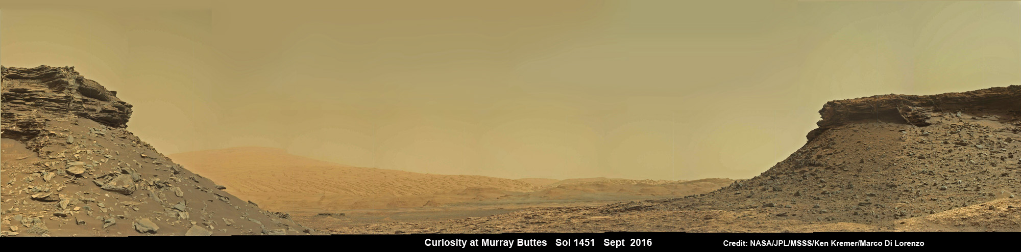
Wide angle mosaic shows lower region of Mount Sharp at center in between spectacular sloping hillsides and layered rock outcrops of the Murray Buttes region in Gale Crater as imaged by the Mast Camera (Mastcam) on NASA’s Curiosity Mars rover. This photo mosaic is stitched from Mastcam camera raw images taken on Sol 1451, Sept. 5, 2016 with added artificial sky. Credit: NASA/JPL/MSSS/Ken Kremer/kenkremer.com/Marco Di Lorenzo
Scanning around the Murray Buttes mosaics one sees finely layered rocks, sloping hillsides, the distant rim of Gale Crater barely visible through the dusty haze, dramatic hillside outcrops with sandstone layers exhibiting cross-bedding. The presence of “cross-bedding” indicates that the sandstone was deposited by wind as migrating sand dunes, says the team.
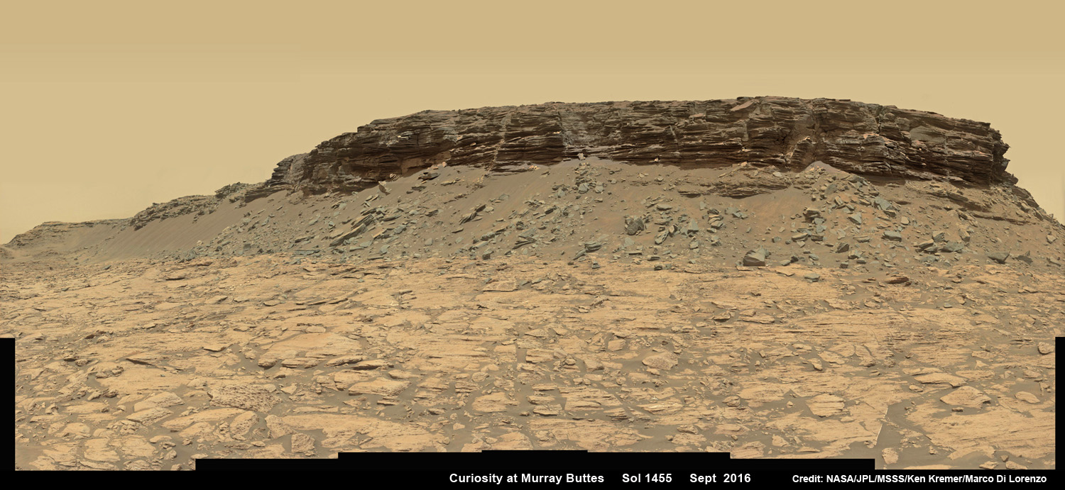
Wide angle mosaic view shows spectacular buttes and layered sandstone in the Murray Buttes region on lower Mount Sharp from the Mastcam cameras on NASA’s Curiosity Mars rover. This photo mosaic was assembled from Mastcam color camera raw images taken on Sol 1455, Sept. 9, 2016 and stitched by Marco Di Lorenzo and Ken Kremer, with added artificial sky. Credit: NASA/JPL/MSSS/Ken Kremer/kenkremer.com/Marco Di Lorenzo
But there is no time to rest as she was commanded to head further south to the last of these Murray Buttes. And right now the team is implementing a plan for Curiosity to drill a new hole in Mars today – at a target named “Quela” at the base of the last of the buttes. The rover approached the butte from the south side a few days ago to get in place and plan for the drilling, take imagery to document stratigraphy and make compositional observations with the ChemCam laser instrument.
“It’s always an exciting day on Mars when you prepare to drill another sample – an engineering feat that we’ve become so accustomed to that I sometimes forget how impressive this really is!” wrote Lauren Edgar, in a mission update today. Edgar is a Research Geologist at the USGS Astrogeology Science Center and a member of the MSL science team.
Curiosity will then continue further south to begin exploring higher and higher sedimentary layers up Mount Sharp. The “Murray Buttes” are the entry way along Curiosity’s planned route up lower Mount Sharp.
Dramatic closeup view of hillside outcrop with sandstone layers showing cross-bedding in the Murray Buttes region on lower Mount Sharp from the Mast Camera (Mastcam) on NASA’s Curiosity Mars rover. This photo mosaic is stitched and cropped from Mastcam camera raw images taken on Sol 1454, Sept. 8, 2016, with added artificial sky. Credit: NASA/JPL/MSSS/Ken Kremer/kenkremer.com/Marco Di Lorenzo
Meanwhile Curiosity is still conducting science observations of the last drill sample gathered from the “Marimba” target in August focusing on MAHLI and APXS examination of the dump pile leftovers from the sieved sample. She just completed chemical analysis of the sieved sample using the miniaturized SAM and CheMin internal chemistry laboratories.
It’s interesting to note that although the buttes are striking, their height also presents communications issues by blocking radio signals with NASA’s orbiting relay satellites. NASA’s Opportunity rover faced the same issues earlier this year while exploring inside the high walled Marathon Valley along Ecdeavour Crater.
“While the buttes are beautiful, they pose a challenge to communications, because they are partially occluding communications between the rover and the satellites we use to relay data (MRO and ODY), so sometimes the data volume that we can relay is pretty low” wrote Edgar.
“But it’s a small price to pay for the great stratigraphic exposures and gorgeous view!”
Dramatic hillside view showing sloping buttes and layered outcrops within of the Murray Buttes region on lower Mount Sharp from the Mast Camera (Mastcam) on NASA’s Curiosity Mars rover. This photo mosaic is stitched and cropped from Mastcam camera raw images taken on Sol 1454, Sept. 8, 2016, with added artificial sky. Credit: NASA/JPL/MSSS/Ken Kremer/kenkremer.com/Marco Di Lorenzo
Ascending and diligently exploring the sedimentary lower layers of Mount Sharp, which towers 3.4 miles (5.5 kilometers) into the Martian sky, is the primary destination and goal of the rovers long term scientific expedition on the Red Planet.
Three years ago, the team informally named the Murray Buttes site to honor Caltech planetary scientist Bruce Murray (1931-2013), a former director of NASA’s Jet Propulsion Laboratory, Pasadena, California. JPL manages the Curiosity mission for NASA.
As of today, Sol 1461, September 15, 2016, Curiosity has driven over 7.9 miles (12.7 kilometers) since its August 2012 landing inside Gale Crater, and taken over 353,000 amazing images.
Stay tuned here for Ken’s continuing Earth and planetary science and human spaceflight news.
Curiosity rover panorama of Mount Sharp captured on June 6, 2014 (Sol 651) during traverse inside Gale Crater. Note rover wheel tracks at left. She will eventually ascend the mountain at the ‘Murray Buttes’ at right later this year. Assembled from Mastcam color camera raw images and stitched by Marco Di Lorenzo and Ken Kremer. Credit: NASA/JPL/MSSS/Marco Di Lorenzo/Ken Kremer-kenkremer.com
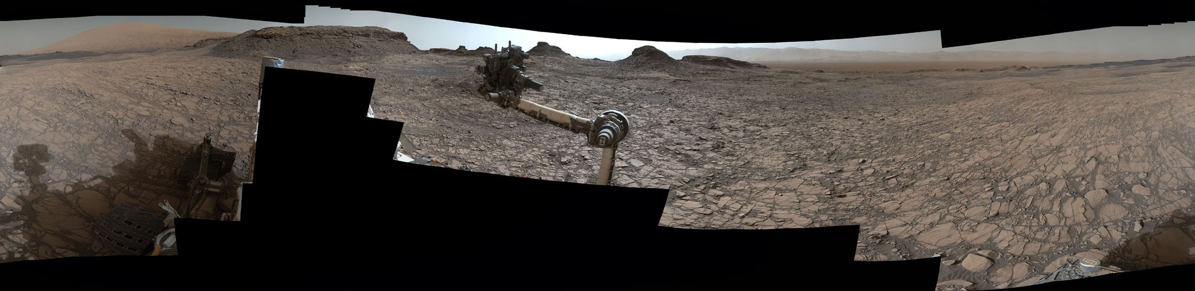
This 360-degree panorama was acquired by the Mast Camera (Mastcam) on NASA's Curiosity Mars rover as the rover neared features called "Murray Buttes" on lower Mount Sharp. Credit: NASA/JPL-Caltech/MSSS
This 360-degree panorama was acquired by the Mast Camera (Mastcam) on NASA’s Curiosity Mars rover as the rover neared features called “Murray Buttes” on lower Mount Sharp. Credit: NASA/JPL-Caltech/MSSS
This is a key milestone for the Curiosity mission because the “Murray Buttes” are the entry way along Curiosity’s planned route up lower Mount Sharp.
Ascending and diligently exploring the sedimentary lower layers of Mount Sharp, which towers 3.4 miles (5.5 kilometers) into the Martian sky, is the primary destination and goal of the rovers long term scientific expedition on the Red Planet.
The area features eroded mesas and buttes that are reminiscent of the U.S. Southwest.
So the team directed the rover to capture a 360-degree color panorama using the robots mast mounted Mastcam camera earlier this month on Aug. 5.
The full panorama shown above combines more than 130 images taken by Curiosity on Aug. 5, 2016, during the afternoon of Sol 1421 by the Mastcam’s left-eye camera.
In particular note the dark, flat-topped mesa seen to the left of the rover’s arm. It stands about 50 feet (about 15 meters) high and, near the top, about 200 feet (about 60 meters) wide.
Coincidentally, Aug. 5 also marks the fourth anniversary of the six wheeled rovers landing on the Red Planet via the unprecedented Sky Crane maneuver.
You can explore this spectacular Mars panorama in great detail via this specially produced 360-degree panorama from JPL. Simply move the magnificent view back and forth and up and down and all around with your mouse or mobile device.
Video Caption: This 360-degree panorama was acquired on Aug. 5, 2016, by the Mastcam on NASA’s Curiosity Mars rover as the rover neared features called “Murray Buttes” on lower Mount Sharp. The dark, flat-topped mesa seen to the left of the rover’s arm is about 50 feet (about 15 meters) high and, near the top, about 200 feet (about 60 meters) wide.
“The buttes and mesas are capped with rock that is relatively resistant to wind erosion. This helps preserve these monumental remnants of a layer that formerly more fully covered the underlying layer that the rover is now driving on,” say rover scientists.
“The relatively flat foreground is part of a geological layer called the Murray formation, which formed from lakebed mud deposits. The buttes and mesas rising above this surface are eroded remnants of ancient sandstone that originated when winds deposited sand after lower Mount Sharp had formed. Curiosity closely examined that layer — the Stimson formation — during the first half of 2016 while crossing a feature called “Naukluft Plateau” between two exposures of the Murray formation.”
Three years ago, the team informally named the site to honor Caltech planetary scientist Bruce Murray (1931-2013), a former director of NASA’s Jet Propulsion Laboratory, Pasadena, California. JPL manages the Curiosity mission for NASA.
As of today, Sol 1447, August 31, 2016, Curiosity has driven over 7.9 miles (12.7 kilometers) since its August 2012 landing, and taken over 348,500 amazing images.
Curiosity explores Red Planet paradise at Namib Dune during Christmas 2015 – backdropped by Mount Sharp. Curiosity took first ever self-portrait with Mastcam color camera after arriving at the lee face of Namib Dune. This photo mosaic shows a portion of the full self portrait and is stitched from Mastcam color camera raw images taken on Sol 1197, Dec. 19, 2015. Credit: NASA/JPL/MSSS/Ken Kremer/kenkremer.com/Marco Di Lorenzo
Stay tuned here for Ken’s continuing Earth and planetary science and human spaceflight news.