Former Astronaut To Take Social Media to New Heights

Scott Parazynski during his attempt to climb Mt. Everest. Credit: OnOrbit.com

[/caption]
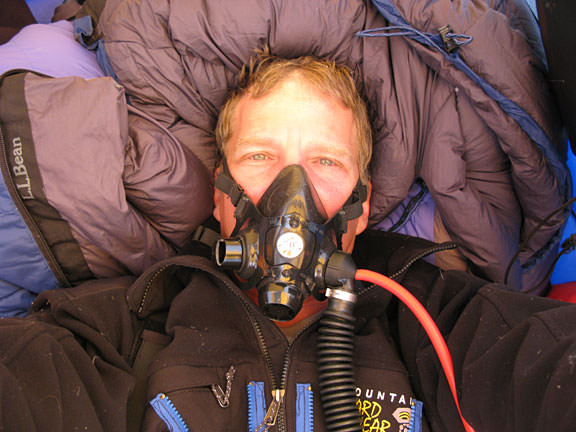
In 2008, astronaut Scott Parazynski came within 24 hours of reaching the summit of Mt. Everest when a painful back injury forced him to abandon his climb. Now, Parazynski is on his way back for another attempt at summitting the world’s highest mountain peak. But this time, he wants to take the rest of the world with him. If everything works as planned, Parazynski will blog, podcast, vodcast and more during the climb, and he even wants to Twitter from the summit. “I want to tell the story of exploration here on Earth and the corollaries it has with space exploration,” Parazynski told Universe Today before he left for Kathmandu, Nepal. “They are both very hostile, unforgiving environments that require a lot of training, a lot of gear, and a lot of thought. The intent is to share the story with as many people as we can, particularly young people.” Parazynski and his team have even agreed to take questions from readers of Universe Today and answer them during their climb.

Mt. Everest mosaic.  Credit: OnOrbit.com
Mt. Everest mosaic. Credit: OnOrbit.com

Parazynski has teamed up with the Challenger Centers for Space Science Education and the Boy Scouts of America to offer educational activities in association with his trek, and is working with various scientists to do field science along the way.

“We’ll be collecting data for astrobiologists, looking for extremophile life,” Parazynski said. “If you understand how extremophiles live, you might be able to understand how life may have once evolved on Mars, or may still exist on Mars.”

As an astronaut, Parazynski was part of 5 space shuttle missions; his last mission to the International Space Station included a daring repair of the ISS’s solar panels.

Parazynski during an EVA. Credit: NASA

Parazynski will also be testing some NASA-derived hardware, taking along a prototype lunar geology camera and other hardware for extreme environments. “Up high on the mountain there are limestone formations, which are wonderful places to look for fossilized life,” he said,” and we’ll also look for melt water and primitive forms of life there; algae lichens, etc. If liquid water exists even for brief periods on Mars it may be in similar conditions to what we’ll find on Mt. Everest. We hope to bring samples back for scientists to look at.”

To help Parazynski, he has enlisted the help of a couple of “media sherpas;” Keith Cowing from NASAWatch and Miles O’Brien, former CNN correspondent. Cowing will definitely be at the base camp, coordinating the media blitz, while O’Brien is still working out his schedule, but hopes to be there as well.

“Scott has the chance to something interesting and wants to share it with as many people as possible,” said Cowing. “This is participatory exploration, where we’ll bring as many people as possible to where we’re going. This is enabled by high end internet connection capable of streaming video. The idea is to open up a vista of participation to a very large audience.”

Cowing said they will have access to email to answer as many questions as possible, and Universe Today will be one of the venues supplying questions from readers. “We’ll be Twittering, videocasting, podcasting, Skyping, emailing, SMSing, blogging , you name it. We’re using every gizmo we’ve got and every avenue of interaction with people, giving them the opportunity to see what it’s like to live in a tent at 17,600 feet.”

The entire expedition will take between 6 -10 weeks, depending on the weather and health of the climbers. Parazyski said it will take several weeks just for the climbers’ bodies to acclimate to the decreased amount of oxygen at those heights. The peak of Mount Everest is 8,848 meters (29,028 feet) above sea level. “We’ll be going up and down to get body used to the conditions,” he said. “Essentially what happens, you need to increase your body’s oxygen carrying capacity, and grow more red blood cells. Your blood chemistry changes to enable you to exchange oxygen more efficiently and that just takes time.” Parazynski, an MD, will be the official physician for the group.

Map of Nepal.  Credit: OnOrbit.com
Map of Nepal. Credit: OnOrbit.com

The Discovery Channel will also be part of the climb, with hopes of creating a documentary of the expedition for their “Everest: Beyond the Limits” series. Cameras will be mounted on the climbers to take video of the experience.

Parazynski is part of a team of 23 climbers. Another team will also be part of the climb, and there will be an additional 20 or 30 climbers to help create the documentary.

The climb officially starts in early May. You can follow the climb via OnOrbit.com/Everest. Parazynski’s whereabouts can also be followed on Google Earth, via his SPOT, a GPS location and message device, which is a commercial sponsor of the climb. The expedition is completely privately funded.

Parazynski is now a “former” NASA astronaut. He announced two weeks ago that he left NASA to work in private industry, at Wyle Labs in Houston. “I had a wonderful experience in the role of astronaut, but now it’s time to pursue other opportunities.”

One other hope for this expedition is to have people participating both on this Earth and off. “If the stars align and everything works just right, we hope to have a satellite phone call between our group and the Hubble repair space shuttle mission,” Parazynski said. Of course, that would depend on if the Hubble mission launches during Parazynski’s climb.

Despite Parazynski’s wish to share his experience with the world, he admits there’s also a strong personal element to this climb. “I went almost the entire way last year and came within 24 hours of summitting,” he said. “It is something I’ve thought of and dreamt about every day since I left the mountain last May, wondering what that last 24 hours will be like, and what it will be like to complete one of the great aspirationa of my entire life.”

Follow OnOrbit.com/Everest for complete coverage. You can follow Parazynski’s Twitter feed, too, SPOTScott, and the OnOrbit Everest Twitter feed. We’ll post regular updates here on Universe Today, along with reminders to submit questions for Parazynski, Cowing and O’Brien by posting your questions in the comments section.

Ozone Success Story: NASA Video of Enviro Action That Worked

Ozone layer hole. Image credit: NASA

[/caption]

Imagine the year 2065. Two-thirds of Earth’s ozone is gone. The infamous ozone hole over Antarctica is a year-round fixture with a twin over the North Pole. People living in mid-latitude cities like Washington, D.C., get sunburned after five minutes. DNA-mutating UV radiation is up 650 percent, with likely harmful effects on plants, animals and human skin cancer rates.

Such is the world we would have inherited if 193 nations had not agreed to ban ozone-depleting substances, according to atmospheric chemists at NASA, Johns Hopkins University in Baltimore and the Netherlands Environmental Assessment Agency in Bilthoven. The researchers have unveiled new computer simulations this week of a worldwide disaster that humans managed to avoid.

In retrospect, the researchers say, the Montreal Protocol was a “remarkable international agreement that should be studied by those involved with global warming and the attempts to reach international agreement on that topic.”

ozone-simulation
This time series from the ozone "World Avoided" model shows the concentration of ozone over the South Pole at four key times. Reds represent normal to high concentrations; blues show depleted areas. Credit: NASA Goddard's Scientific Visualization Studio

Ozone is Earth’s natural sunscreen, absorbing and blocking most of the incoming UV radiation from the sun and protecting life from DNA-damaging radiation. The gas is naturally created and replenished by a photochemical reaction in the upper atmosphere where UV rays break oxygen molecules into individual atoms that then recombine into three-part molecules (O3). As it is moved around the globe by upper level winds, ozone is slowly depleted by naturally occurring atmospheric gases. It is a system in natural balance.

But chlorofluorocarbons — invented in 1928 as refrigerants and as inert carriers for chemical sprays — upset that balance. Researchers discovered in the 1970s and 1980s that while CFCs are inert at Earth’s surface, they are quite reactive in the stratosphere (10 to 50 kilometers altitude, or 6 to 31 miles), where roughly 90 percent of the planet’s ozone accumulates. UV radiation causes CFCs and similar bromine compounds in the stratosphere to break up into elemental chlorine and bromine that readily destroy ozone molecules. 

In the 1980s, ozone-depleting substances opened a wintertime “hole” over Antarctica and opened the eyes of the world to the effects of human activity on the atmosphere.  In January 1989, the Montreal Protocol went into force, the first-ever international agreement on regulation of chemical pollutants.

In the new study, published online in the journal Atmospheric Chemistry and Physics, Goddard scientist Paul Newman and his team simulated “what might have been” if chlorofluorocarbons (CFCs) and similar chemicals were not banned. The simulation used a comprehensive model that included atmospheric chemical effects, wind changes, and radiation changes. The “World avoided” video can be viewed here in Quicktime (for more formats, go here).

By the simulated year 2020, 17 percent of all ozone is depleted globally. An ozone hole starts to form each year over the Arctic, which was once a place of prodigious ozone levels.

By 2040, global ozone concentrations fall below the same levels that currently comprise the “hole” over Antarctica. The UV index in mid-latitude cities reaches 15 around noon on a clear summer day, giving a perceptible sunburn in about 10 minutes. Over Antarctica, the ozone hole becomes a year-round fixture.

By the end of the model run in 2065, global ozone drops 67 percent compared to 1970s levels. The intensity of UV radiation at Earth’s surface doubles; at certain shorter wavelengths, intensity rises by as much as 10,000 times. Skin cancer-causing radiation soars.

“Our world avoided calculation goes a little beyond what I thought would happen,” said Goddard scientist and study co-author Richard Stolarski, who was among the pioneers of atmospheric ozone chemistry in the 1970s. “The quantities may not be absolutely correct, but the basic results clearly indicate what could have happened to the atmosphere.”

“We simulated a world avoided,” added Newman, “and it’s a world we should be glad we avoided.”

As it is, production of ozone-depleting substances was mostly halted about 15 years ago, though their abundance is only beginning to decline because the chemicals can reside in the atmosphere for 50 to 100 years. The peak abundance of CFCs in the atmosphere occurred around 2000, and has decreased by roughly 4 percent to date. Stratospheric ozone was depleted by 5 to 6 percent at middle latitudes, but has somewhat rebounded in recent years.

Vernal Equinox – Busting the Myth of Balancing Eggs

Season Diagram courtesy of NOAA

[/caption]

Spring officially arrives for everyone, including astronomers on March 20. The word “Equinox” literally means “equal night”. It’s all about the balance of light – not the myth of balancing eggs. On the universal date (UTC) of Friday, March 20, 2009 at 11:44 (am) both the day and night are the same length. But what’s so special about it? It’s a date that most of us recognize as symbolic of changing seasons. North of Earth’s equator we welcome Spring, while people south of the equator are gearing up for the cooler temperatures of Autumn. But what’s all this about balancing eggs?

These all too brief, but monumental moments in Earth-time, owe their significance to the slightly more than 23 degree tilt of the Earth’s axis. Because of our planetary angle, we in the northern hemisphere receive the Sun’s rays most directly during the Summer. In the Winter, when we are tilted away from the Sun, the rays pass through the atmosphere at a greater slant, bringing lower temperatures. If the Earth rotated on an axis perpendicular to the plane of the Earth’s orbit around the Sun, there would be no variation in day lengths or temperatures throughout the year, and we would not have seasons. At Equinox, the midway between these two times in Spring and Autumn, the spin axis of the Earth points 90 degrees away from the Sun.

analemma_vr_bigIf your head is spinning from all of this, sit and ponder for a moment. Now is a great time to choose a marker and observe what’s happening for yourself. Trying a real science experiment for equinox is much better than the myth of balancing eggs. Just place a stake of some type into the ground (or use a fencepost or signpost) and periodically over the next few weeks measure the length of the shadow when the Sun is at its highest and write down your measurements. I use my south facing deck railing and mark its shadow on the deck boards in chalk. It won’t take long before your marker’s shadow length changes and you notice how the Sun’s position changes in the sky, and with it the ecliptic plane.

In the language of astronomy, an equinox is either of two points on the celestial sphere where the ecliptic and the celestial equator intersect. The Vernal Equinox is also known as “the first point of Aries” – a the point at which the Sun appears to cross the celestial equator from south to north. This is also the the zero point of longitude – the reference plane at which right ascension is defined as 0. Believe it or not, this was defined in 1950 as the northern vernal equinox, but it has moved to the constellation of Pisces now! Why? The equinoxes are not fixed points on the celestial sphere but move westward along the ecliptic, passing through all the constellations of the zodiac in 26,000 years. This is what’s known as the precession of the equinoxes – a motion first noted by Hipparchus roughly in 120 B.C. But what causes it?

full-526px-earth_precessionsvgThe precession is caused the gravitational attraction of both the Moon and Sun on the equatorial bulge of the Earth. Imagine the Earth’s axis patterning itself in a cone as it moves, like a spinning top. As a result, the celestial equator, which lies in the plane of the Earth’s equator, moves on the celestial sphere, while the ecliptic, which lies in the plane of the Earth’s orbit around the Sun, is not affected by this motion. The equinoxes, which lie at the intersections of the celestial equator and the ecliptic, now move on the celestial sphere. Much the same, the celestial poles move in circles on the celestial sphere, so that there is a continual change in the star at or near one of these poles.

After a period of about 26,000 years the equinoxes and poles lie once again at nearly the same points on the celestial sphere. Because the gravitational effects of the Sun and Moon aren’t always the same, there is some wobble in the motion of the Earth’s axis called nutation. This wobble causes the celestial poles to move, not in perfect circles, but in a series of S-shaped curves with a period of 18.6 years that was first explained by Isaac Newton in 1687.

So where did the urban myth of balance eggs on vernal equinox come from? Probably because at one time Easter was celebrated at this time and eggs play a very big role in the whole Esotere, rebirth, and cultural symbolism of this holiday. It may very well have been the good folks in China who orginally began the myth by patiently practicing standing eggs on end during vernal equinox to symbolize the restoration of balance to the world after a season of darkness. If this symbol of fertility could be balanced on such a day of significance, then surely nature was in harmony!

Go ahead and balance eggs for fun… But believe in science.

P.S. The Bad Astronomer Phil Plait has a tutorial video on his website, teaching you how to stand an egg on end, any time of the year. Click here to watch it.

Many thanks to Vasilij Rumyantsev (Crimean Astrophysical Obsevatory) for the excellent solar analemma as it appeared in the July 9, 2002 APOD.

Indian Balloon Experiment Nets Three New Bacteria

[/caption]

Indian scientists flying a giant balloon experiment have announced the discovery of three new species of bacteria from the stratosphere.

In all, 12 bacterial and six fungal colonies were detected, nine of which, based on gene sequencing, showed greater than 98 percent similarity with reported known species on earth. Three bacterial colonies, however, represented totally new species. All three boast significantly higher UV resistance compared to their nearest phylogenetic neighbors on Earth.

The experiment was conducted using a balloon that measures 26.7 million cubic feet  (756,059 cubic meters) carrying 1,000 pounds (459 kg) of scientific payload soaked in liquid Neon. It was flown from the National Balloon Facility in Hyderabad, operated by the Tata Institute of Fundamental Research (TIFR). 

An onboard cryosampler contained sixteen evacuated and sterilized stainless steel probes. Throughout the flight, the probes remained immersed in liquid Neon to create a cryopump effect. The cylinders, after collecting air samples from different heights ranging from 20 km to 41 km (12 to 25 miles) above the Earth’s surface, were parachuted down and retrieved. The samples were analyzed by scientists at the Center for Cellular and Molecular Biology in Hyderabad as well as the National Center for Cell Science in Pune for independent confirmation.

One of the new species has been named as Janibacter hoylei, after the astrophysicist Fred Hoyle, the second as Bacillus isronensis recognizing the contribution of ISRO in the balloon experiments which led to its discovery, and the third as Bacillus aryabhata after India’s celebrated ancient astronomer Aryabhata (also the name of ISRO’s first satellite).

The researchers have pointed out in a press release that precautionary measures and controls operating in the experiment inspire confidence that the new species were picked up in the stratosphere.

“While the present study does not conclusively establish the extra-terrestrial origin of microorganisms, it does provide positive encouragement to continue the work in our quest to explore the origin of life,” they added.

This was the second such experiment conducted by ISRO, with the first one in 2001. Even though the first experiment had yielded positive results, the researchers decided to repeat the experiment while exercising extra care to ensure that it was totally free from any terrestrial contamination.

Source: Indian Space Research Organisation

Additional links: Center for Cellular and Molecular BiologyNational Center for Cell Science, Tata Institute of Fundamental Research

Arizona Scientist: We Could All Be Martians

Artist's conception of an fragment as it blasts off from Mars. Boulder-sized planetary fragments could be a mechanism that carried life between Mars and Earth, UA planetary scientist Jay Melosh says. (Credit: The Planetary Society)

[/caption]

As long as we’re still pondering human origins, we may as well entertain the idea that our ancestor microbes came from Mars.

And Jay Melosh, a planetary scientist from the University of Arizona in Tucson, is ready with a geologically plausible explanation.

Meteorites.

“Biological exchange between the planets of our solar system seem not only possible, but inevitable,” because of meteorite exchanges between the planets, Melosh said. “Life could have originated on the planet Mars and then traveled to Earth.”

jay_melosh
Jay Melosh. Credit: Maria Schuchardt, University of Arizona Lunar and Planetary Lab

Melosh is a long-time researcher who says he’s studied “geological violence in all its forms.” He helped forge the giant impact theory of the moon’s formation, and helped advance the theory that an impact led to the extinction of the dinosaurs 65 million years ago.

He points out that Martian meteorites have been routinely pummeling Earth for billions of years, which would have opened the door for past Mars microbes to hitch a ride. Less regularly, Earth has undergone impacts that sent terrestrial materials flying, and some of those could have carried microbes toward the Red Planet.

“The mechanism by which large impacts on Mars can launch boulder-sized surface rocks into space is now clear,” he said. He explained that a shock wave spreads away from an impact site faster than the speed of sound, interacting with the planetary surface in a way that allows material to be cast off – at relatively low pressure, but high speed.

“Lightly damaged material at very high speeds,” he said, “is the kind of environment where microorganisms can survive.”

Scientists have recent evidence of Earth microbes surviving a few years in space. When the Apollo 12 astronauts landed on the moon, they retrieved a camera from Surveyor 3, an unmanned lander that had touched down nearly three years prior. Earthly microbes – including those associated with the common cold — were still living inside the camera box.

“The records were good enough to show one of the technicians had a cold when he was working on it,” he said.

Scientists also have evidence that microbes can survive for thousands or even hundreds of thousands of years when frozen on Earth, but surviving that long in space would be an entirely different matter, with the bombardment of UV light and cosmic rays. Then again, the microbe Dienococcus radiodurans is known to survive in the cores of nuclear reactors.

Melosh acknowledges that scientists lack proof that such an exchange has actually occurred between Mars and Earth — but science is getting ever closer to being able to track it down. 

LEAD PHOTO CAPTION: Artist’s conception of an fragment as it blasts off from Mars. Boulder-sized planetary fragments could be a mechanism that carried life between Mars and Earth, UA planetary scientist Jay Melosh says. (Painting by Don Davis. Copyright SETI Institute, 1994)

Source: University of Arizona and an interview with Jay Melosh

Earth Hour 2009 – Where Will You Be When The Lights Go Out?

With less than six weeks to go, more than 500 cities around the world have officially agreed to go dark in support of global action on climate change. On March 28, 2009 at 8:30 p.m., local time, World Wildlife Fund is asking individuals, businesses, governments and organizations around the world to turn off their lights for one hour — Earth Hour — to make a global statement of concern about climate change and to demonstrate their commitment to finding solutions. Step inside and find out how you can become a part of this historic event…

Wherever you happen to be in the world on March 28th at 8:30 p.m., you’re likely to find a city or community somewhere nearby that is making plans to turn out the lights for Earth Hour – a global goal of 1,000 cities! WWF’s initiative aims to increase awareness about climate change and demonstrate that people from all over the world care about the issue. “Climate change and what we do about it is going to transform the world much more rapidly than people realize.” say Richard Moss, Vice President and Managing Director for Climate Change. “It’s my goal to get us moving to a world we will want, not one we’ll regret leaving for our children and grandchildren.”

Before you start knocking “Earth Hour” as something that just won’t make a difference, take just a moment of your time and watch this, please…

And now, here are some highlights of what’s going on around Earth Hour 2009 as we count down the days…

NASHVILLE: Earth Hour launched in Music City with a musical press conference that included live performances by Nashville superstars pledging to turn out against climate change.

THE STARS AND STRIPES ARE ALIGNING: Houston, TX; Santa Rosa, CA; St Louis, MO; Sarasota, FL; Minneapolis, MN; and Valdosta, GA signed up to be part of Earth Hour 2009. They join Atlanta, Chicago, Dallas, Las Vegas, Los Angeles, Miami, Nashville, New York City and San Francisco.

NOBEL PEACE PRIZE WINNER ARCHBISHOP DESMOND TUTU ANNOUNCES HIS SUPPORT: “Climate change is the greatest human induced crisis facing the world today. It is totally indiscriminate of race, culture and religion. It affects every human being on the planet. Earth Hour is an opportunity for every man, woman and child from all corners of the globe to come together with a united voice and make a loud and powerful statement on the issue of climate change.”

BACK TO MY OLD SCHOOL: The University of Miami became the first American campus to officially sign up to turn off, but was quickly joined by Michigan State, University of Nevada, Las Vegas, University of Virginia, Belmont, Columbia, Ohio University, Howard University, Georgia Tech, Northwestern, Spellman, University of Missouri, St. Louis and Vanderbilt.

I GOT THE POWER: 10,000 college students from across the nation will converge on Washington DC on February 27–March 2 for Power Shift ’09, asking for “bold, comprehensive and immediate federal climate action.” Earth Hour Project Director Meg Pearce and Campus Organizer Sophie Latham will be there holding a special session on how to be part of Earth Hour 2009, the largest global climate event in history.

CITY OF LIGHTS TO TURN LIGHTS OFF IN SUPPORT OF WWF’S EARTH HOUR 2009: Paris—known as the City of Lights—will lead a list of 28 cities and towns across France that have committed to join the world in making a visual vote for decisive action on climate change by turning off their lights for one hour during Earth Hour 2009 on March 28th.

LAS VEGAS FLICKS THE SWITCH FOR EARTH HOUR 2009: Officials from World Wildlife Fund joined Clark County, Nevada Commissioner Lawrence Weekly, City of Las Vegas Mayor Oscar B. Goodman and City of Henderson Mayor James B. Gibson at the iconic “Welcome to Fabulous Las Vegas” sign to officially kick off the Las Vegas Valley’s participation in Earth Hour–a global event calling for action on climate change.

For now? Be sure to visit the Earth Hour website, where you can sign up to show your support and find all kinds of wonderful tools and ideas on how to motivate your community, school, family and friends to pledge just one hour of their time to darkness and become part of this global event.

Don’t forget to mark your calendar…Earth Hour is March 28, 2009, at 8:30 pm. Be there with us when the lights go out…

New Company Looks to Produce Space Based Solar Power Within a Decade

Solar Collecting Satellite. Image courtesy of Mafic Studios.

[/caption]
Is space-based solar power (SBSP) a technology whose time has come? The concept and even some of the hardware for harnessing energy from the sun with orbiting solar arrays has been around for some time. But the biggest challenge for making the concept a reality, says entrepreneur Peter Sage of Space Energy, Inc., is that SBSP has never been commercially viable. But that could be changing. Space Energy, Inc. has assembled an impressive team of scientists, engineers and business people, putting together what Sage calls “a rock-solid commercial platform” for their company. And given the current looming issues of growing energy needs and climate change, Space Energy, Inc. could be in the right place at the right time.

“Although it’s a very grandiose vision, it makes total sense,” Sage told Universe Today. “This is an inevitable technology; it’s going to happen. If we can put solar panels in space where the sun shines 24 hours a day, if we have a safe way of transmitting the energy to Earth and broadcasting it anywhere, that is a serious game changer.” If everything falls into place for this company, they could be producing commercially available SBSP within a decade.

The basic concept of SBSP is having solar cells in space collecting energy from sun, then converting the energy into a low intensity microwave beam, sending it down to Earth where it is collected on a rectenna, and then fed into the power grid to provide electricity. Almost 200 million gigawatts of solar energy is beamed towards the Earth every second, which is more energy than our civilization has used since the dawn of the electrical age. We only need a way to harness that energy and make it usable.

Space Energy, Inc.’s vision is to help create an energy-independent world, and improve the lives of millions of people by bringing a source of safe, clean energy to the planet from space. They are looking to become the world’s leading, and perhaps the first, SBSP enterprise.

Solar collector beaming energy to Earth.  Image courtesy Mafic Studios.
Solar collector beaming energy to Earth. Image courtesy Mafic Studios.

“The biggest challenge for SBSP is making it work on a commercial level in terms of bottom line,” said Sage, “i.e., putting together a business case that would allow the enormous infrastructure costs to be raised, the plan implemented, and then electricity sold at a price that is reasonable. I say ‘reasonable’ and not just ‘competitive’ because we’re getting into a time where selling energy only on a price basis isn’t going to be the criteria for purchase.”

Currently, there are times in the US when electricity is sold wholesale for close to a dollar a kilowatt during peak usage or times of emergency when power needs to be shipped around the national grid. Sage said SBSP will never be cost comparable with the current going rate of 6 or 7 cents a kilowatt due to the enormous set-up costs.

“We believe we can get it to a reasonable price, a fair market price as the demand for energy increases,” Sage said.

A huge energy gap is looming for our world, and that too, will change the energy game.

According to a white paper written by aerospace engineer James Michael Snead, “The End of Easy Energy and What Are We Going To Do About It,” in order to meet the world’s projected increase in energy needs by 2100 which likely will be at least three times what is being produced today, today’s sustainable energy production must expand by a factor of over 25. Under that scenario, even if the US were to build 70 new nuclear plants, add the equivalent of 15 more Hoover Dams, expand the geothermal capacity by 50 times what it is today, install over a million large land or sea wind turbines covering 150,000 square miles, build 60,000 square miles of commercial solar voltaic farms, and on top of that convert 1.3 billion dry tons of food mass to bio fuels, still only 30% of the power needs would be filled by 2100, or perhaps even earlier.

“Looking at every single technology we can as a civilization to try and fill the energy gap in a clean and resourceful, sustainable way, technologies like SBSP have to be made to work,” said Sage.

Peter Sage.  Image courtesy Space Energy, Inc.
Peter Sage. Image courtesy Space Energy, Inc.

He says this is an important point. “We’re not setting ourselves up to compete with coal, or nuclear, or ground based solar or wind. I don’t want to pick a fight with any of those industries saying that we’re trying to take a piece of their pie. What we’re saying is that right now, from a responsible perspective in terms of being a good steward for the environment, we need to look at every single source of energy that we can get our hands on, primarily green, and develop it regardless, because we’re going to need it. SBSP is one of the few forms of energy that has the ability to be base-load, i.e., 24-7, and it’s the only form of energy that can be broadcast on demand.”

The first phase of Space Energy, Inc.’s plan is to launch a small prototype satellite into low Earth orbit. “This will help validate the numbers we are speculating on at this point, but also validate several different aspects of what SBSP can do,” said Sage. “From a successful demonstration, we are hoping to close power purchase agreements with one of several entities we are in discussions with at present. And on the strength of that we should be able to put the first commercial satellite in orbit.”

With regards to the timetable, Sage was hesitant to commit to a schedule. “As timetables go, everything needs to be flexible, but we are looking to close the financing for the demonstrator during the first quarter of this year (2009). The demonstrator is a 24 to 36 month project and, from there, we will start the commercial build-out of the main satellite, which could take up to four years to be operational.”

Satellites in orbit collecting solar power.  Image: National Space Society.
Satellites in orbit collecting solar power. Image: National Space Society.

That’s an aggressive schedule. But Sage said since their plan is being driven from a commercial basis, they can run their operation differently than government agencies who don’t necessarily operate with the bottom line in mind. “Our board members and entrepreneurial group certainly have a lot of experience running commercial entities. We know what we’re doing. We’re in a market that we hope to pioneer, and everyone feels confident that we have what it takes. We certainly have the passion, vision and enthusiasm to make this happen.”

What are the biggest hurdles to overcome in this project? “If you would have asked me that question a few months ago,” Sage replied, “I would have said a combination of meeting the right people who could understand the vision and scope of what it is what we’re doing, and raising the initial financing for the demonstrator. Those hurdles, at this point, really seem to be taken care of. The more we have our technical teams talk with investors, the more people understand that we’re real and this isn’t some sort of Star Trek giggle factor. Right now, with the level of due diligence that’s been done not only on SBSP itself, but with ourselves as a commercially viable entity, we’re on the forefront of many people’s agenda in terms of how to move this forward. We see a straight path to making this a reality.”

Sage said no new technology is needed for the demonstrator, which will be a working, small prototype, but challenges do remain to move forward beyond that. “Obviously, there are technical challenges because something of this scale has never been done before. We know we can do wireless power transmission, as NASA did some pretty significant tests on this in the 1970s. We know the physics of wireless power transmission, and how everything should work from geostationary orbit.”

While the demonstrator won’t be of any scale where energy could be sold commercially, it would be a proof of concept.

“Once we’ve demonstrated that we can wirelessly beam power accurately to the ground in a safe, controlled, effective manner, and in a way that can be metered and measured,” said Sage, “we will have taken a massive step forward to prove that SBSP is a technology of the future that has the potential to really fill a gap in the world’s energy needs.”

Some have equated developing SBSP to what was accomplished with the Apollo program.

“There are so many positive spinoffs to SBSP as a game changing foundation of space commerce, that just by addressing a lot of the challenges that lay ahead, we will be blazing a trail for many other opportunities for a low earth orbit economy,” Sage added.

A rectenna on Earth collects microwaved energy from space solar collectors.  Image courtesy Mafic Studios.
A rectenna on Earth collects microwaved energy from space solar collectors. Image courtesy Mafic Studios.

Space Energy, Inc. recently attended the World Future Energy Summit and has been overwhelmed with the response.

“We’ve had discussions with many different entities, both governmental and private, in the Middle East; Abu Dhabi, United Arab Emirates, Jordan, Dubai, many areas around Europe, and many of the world’s top investment firms. I don’t think we’re going to be short of people that will want to support us.” Sage added that in general, SBSP has strong support in Washington DC, and that SBSP recently was added to a list of technologies being studied by the Obama administration.

SBSP has ability to literally change the course of history, and impact the quality of life for people everywhere. Sage said this project is an entrepreneurs’ dream.

“I speak for our entire team here, we’re not just focused on how much money are we going to make,” Sage said. “We’re focused on the fact that this is an inevitable technology and someone is going to do it. Right now we’re the best shot. We’re also focused on the fact that, according to every scenario we’ve analyzed, the world needs space based solar power, and it needs it soon, as well as the up-scaling of just about every other source of renewable energy that we can get our hands on.”

“Space based solar power will happen whether we crack cold fusion, or whether we suddenly go to 80% efficiency on ground based solar power (currently its only at 50%),” Sage continued. “It has to happen based on the nature on what it is. With that in mind, I’ve been willing to put everything I have on the line to be able to make this work, and that was three years, ago. To see how far we’ve come in the past six to eight months has been amazing.”

“This is going to happen.”

For more information:
Space Energy, Inc.
Space Energy, Inc.’s interactive flash presentation
Video presentation on Space Based Solar Power by Mafic Studios

NASA Study Predicted Outbreak of Deadly Virus

Scientists have long suspected that climatic variables like sea surface temperature and precipitation could foreshadow outbreaks of disease. Now, they have confirmation.

Responding to a deadly 1997 outbreak of the mosquito-borne disease Rift Valley fever, researchers had developed a “risk map,” pictured above, using NASA and National Oceanic and Atmospheric Administration measurements of sea surface temperatures, precipitation, and vegetation cover. As reported in a recent NASA-led study, the map gave public health officials in East Africa up to six weeks of warning for the 2006-2007 outbreak of the deadly Rift Valley fever in northeast Africa — enough time to lessen human impact.

On the map above, pink areas depict increased disease risk, while pale green areas reflect normal risk. Yellow dots represent reported Rift Valley fever cases in high-risk areas, while blue dots represent occurrences in non-risk areas. The researchers have detailed the map’s effectiveness in the Proceedings of the National Academy of Sciences.

313585main_riftvalley_scientists_hi
Scientists study a typical dambo habitat at Sukari Farm, a long-term Rift Valley Fever study site just outside Nairobi, Kenya. Dambos are natural breeding grounds for disease-carrying mosquitoes and can be observed from space with the aid of satellites. Credit: Assaf Anyamba

During an intense El Niño event in 1997, the largest known outbreak of Rift Valley fever spread across the Horn of Africa. About 90,000 people were infected with the virus, which is carried by mosquitoes and transmitted to humans by mosquito bites or through contact with infected livestock. That outbreak prompted the formation of a working group — funded by the U.S. Department of Defense Global Emerging Infections Surveillance and Response System — to try to predict future outbreaks.

The working group didn’t start from scratch. The link between the mosquito life cycle and vegetation growth was first described in a 1987 Science paper by co-authors Kenneth Linthicum of the U.S. Department of Agriculture and Compton Tucker of NASA’s Goddard Space Flight Center. Later, a 1999 Science paper described a link between Rift Valley fever and the El Niño-Southern Oscillation, a cyclical, global phenomenon of sea surface temperature changes that can contribute to extreme climate events around the world.

Building on that research, Assaf Anyamba of NASA Goddard and the University of Maryland, and his colleagues, set out to predict when conditions were ripe for excessive rainfall — and thus an outbreak. They started by examining satellite measurements of sea surface temperatures. One of the first indicators that El Niño will boost rainfall is a rise in the surface temperature of the eastern equatorial Pacific Ocean and the western equatorial Indian Ocean. Perhaps the most telling clue is a measure of the mosquito habitat itself. The researchers used a satellite-derived vegetation data set that measures the landscape’s “greenness.” Greener regions have more than the average amount of vegetation, which means more water and more potential habitat for infected mosquitoes. The resulting risk map for Rift Valley fever, showing areas of anomalous rainfall and vegetation growth over a three-month period, is updated and issued monthly as a means to guide ground-based mosquito and virus surveillance.

As early as September 2006, the monthly advisory from Anyamba and colleagues indicated an elevated risk of Rift Valley fever activity in East Africa. By November, Kenya’s government had begun collaborating with non-governmental organizations to implement disease mitigation measures—restricting animal movement, distributing mosquito bed nets, informing the public, and enacting programs to control mosquitoes and vaccinate animals. Between two and six weeks later—depending on the location—the disease was detected in humans.

After the 2006-2007 outbreak, Anyamba and colleagues assessed the effectiveness of the warning maps. They compared locations that had been identified as “at risk” with the locations where Rift Valley fever was reported. Of the 1,088 cases reported in Kenya, Somalia, and Tanzania, 64 percent fell within areas delineated on the risk map. The other 36 percent of cases did not occur within “at risk” areas, but none were more than 30 miles away, leading the researchers believe that they had identified most of the initial infection sites.

The potential for mapping the risk of disease outbreaks is not limited to Africa. Previous research has shown that risk maps are possible whenever the abundance of a virus can be linked to extremes in climate conditions. Chikungunya in east Africa and Hantavirus and West Nile virus in the United States, for example, have been linked to conditions of rainfall extremes.

“We are coming up on almost 30 years of vegetation data from satellites, which provides us with a good basis for predicting,” said Linthicum, co-author on the 1987 paper, upon his return from a Rift Valley fever workshop in Cairo, Egypt last month. “At this meeting, it was clear that using this tool as a basis for predictions has become accepted as the norm.”

Sources: NASA and the Proceedings of the National Academy of Sciences

Climate Change Satellite gets Green Light for Launch

The European Space Agency’s Soil Moisture and Ocean Salinity (SMOS) satellite has been cleared for takeoff, following nearly a year in limbo while the mission team awaited the go-ahead from a private launch company.

Originally expected to launch in 2008, SMOS has been in storage at Thales Alenia Space’s facilities in Cannes, France since last May, awaiting a  launch appointment at the Russian Plesetsk Cosmodrome, north of Moscow. If all goes according to plan, the craft will now launch between July and October, the second ESA mission in a series of six designed to observe Earth from space and bolster an understanding of climate change. The first of the satellites in its new Living Planet Program, The Gravity field and steady-state Ocean Circulation Explorer (GOCE), is scheduled to go up March 16. 


Over its lifetime of about 20 months, GOCE will map global variations in the gravity field – crucial for deriving accurate measurements of ocean circulation and sea-level change, both of which are affected by climate change.

SMOS, circulating at a low orbit of around 750 km (466 miles) above the Earth,  will be the first mission dedicated to mapping soil moisture and ocean salinity. Salinity in the oceans has a significant impact on ocean circulation, which in turn helps drive the global climate. Among other applications, understanding the salinity and temperature of the seas will lead to easier predictions of the zones where hurricanes intensify. A specialized radiometer has been developed for the mission that is capable of observing both soil moisture and ocean salinity by capturing images of emitted microwave radiation around the frequency of 1.4 GHz (L-band). SMOS will carry the first-ever, polar-orbiting, space-borne, 2-D interferometric radiometer. The mission is designed to last three years.

Here’s a rundown of the final four planned crafts in the series:

  • ADM-Aeolus (Atmospheric Dynamics Mission), with a 2010 launch date, will collect data about the global wind profile to improve weather forecasting.
  • CryoSat-2, set to launch in late 2009, will determine variations in the thickness of the Earth’s continental ice sheets and marine ice cover to further our understanding of the relationship between ice and global warming. CryoSat-2 replaces CryoSat, which was lost at launch in 2005.
  • Swarm, due for launch in 2010, is a constellation of three satellites to study the dynamics of the magnetic field to gain new insights into the Earth system by studying Earth’s interior and its environment.  
  • EarthCARE (Earth Clouds Aerosols and Radiation Explorer), lanching in 2013, is a joint European-Japanese mission that aims to improve the representation and understanding of the Earth’s radiative balance in climate and numerical weather forecast models.
Source: ESA

Google Oceans, Google Mars

The Mars feature of Google Earth 5.0 lets users see the Red Planet from the perspective of Rovers like the NASA Mars Pathfinder Rover. (Credit: NASA/Google/JPL/University of Arizona)

[/caption]
Google Earth now allows you to probe the depths of Earth’s oceans as well as fly through the giant canyons or volcanoes on Mars. Google Earth 5.0 was unveiled today, with substantial upgrades for both the Earth and the Red Planet. Google worked in conjunction with NOAA and NASA to incorporate data from our undersea explorations and the spacecraft orbiting Mars. For the first time, you’ll be able to look at the two-thirds of our planet covered by the oceans, take a tour below sea level, and even look at historical imagery to see things like coastal erosion. On Mars there’s a rich conglomeration of images, including the most recent from the Mars Reconnaissance Orbiter to provide an immersive 3D view of Mars. Marine scientists say the electronic images will boost awareness and increase public support for marine conservation, while NASA says the new features in Google Mars will aid public understanding of Mars science, while also providing researchers a platform for sharing data similar to what Google Earth provides for Earth scientists.

In Google Oceans, you can click a function called Touring and you can create narrated, illustrated tours, on land or above and below the sea surface, describing and showing things like a hike or scuba excursion, or even a research cruise on a deep-diving submarine.

A view of the coast of Maui, outside Lanai City, Hawaii, from the new version of Google Earth.

By choosing among 20 buttons holding archives of information, called “layers” by Google, a visitor can read logs of oceanographic expeditions, see old film clips from the heyday of Jacques-Yves Cousteau and check daily Navy maps of sea temperatures.

While only 5% of the ocean floor is mapped in detail, the replicated seas have detailed topography reflecting what is known about the abyss and continental shelves with rougher areas where little is known.

On Mars, you can enjoy a high-resolution, three-dimensional view of the Red Planet.

There is a mode that enables users to fly virtually through enormous canyons and scale huge mountains on Mars that are much larger than any found on Earth. Users also can explore the Red Planet through the eyes of the Mars rovers and other Mars missions, providing a unique perspective of the entire planet.

Clickable links allow you to learn about new discoveries and explore indexes of available Mars imagery. If you’re into working with the raw images from the Mars rovers or orbiting spacecraft, the new Mars mode also allows users to add their own 3D content to the Mars map to share with the world.

Since 2005, Google Earth has been downloaded on half a billion computers, and visitors spend one million hours a day perusing Google Earth and the related Google Maps.

Guess what I’ll be doing the next few hours!

Download Google Earth 5.0.

Sources: NASA, New York Times